

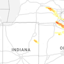
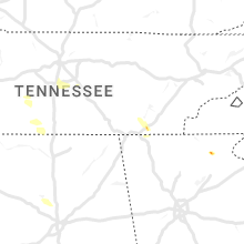
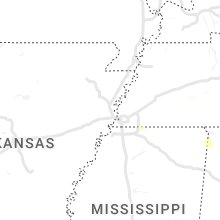
Hail Map for Thursday, June 15, 2023

Number of Impacted Households on 6/15/2023
0
Impacted by 1" or Larger Hail
0
Impacted by 1.75" or Larger Hail
0
Impacted by 2.5" or Larger Hail
Square Miles of Populated Area Impacted on 6/15/2023
0
Impacted by 1" or Larger Hail
0
Impacted by 1.75" or Larger Hail
0
Impacted by 2.5" or Larger Hail


Cities Most Affected by Hail Storms of 6/15/2023
| Hail Size | Demographics of Zip Codes Affected | ||||||
|---|---|---|---|---|---|---|---|
| City | Count | Average | Largest | Pop Density | House Value | Income | Age |
| Sanger, TX | 4 | 3.13 | 5.00 | 111 | $91k | $48.0k | 36.4 |
| Lawton, OK | 3 | 2.83 | 4.00 | 126 | $66k | $30.3k | 34.5 |
| Fort Sill, OK | 3 | 2.42 | 3.00 | 59 | $65k | $37.5k | 21.9 |
| Toledo, OH | 3 | 2.17 | 2.50 | 2861 | $83k | $37.4k | 38.5 |
| Ashland, OH | 3 | 1.92 | 2.25 | 208 | $96k | $37.9k | 38.4 |
| Jacksonville, TX | 3 | 1.83 | 2.00 | 87 | $52k | $28.3k | 34.8 |
| Hooker, OK | 2 | 2.25 | 2.50 | 3 | $62k | $36.1k | 32.9 |
| Canadian, TX | 2 | 2.13 | 2.50 | 3 | $57k | $35.4k | 35.6 |
| Atmore, AL | 2 | 2.13 | 2.50 | 49 | $69k | $27.2k | 38.0 |
| Sayre, OK | 2 | 2.00 | 2.00 | 11 | $33k | $25.8k | 35.6 |
| Tuttle, OK | 2 | 1.88 | 2.00 | 104 | $91k | $45.0k | 38.3 |
| Lone Grove, OK | 2 | 1.75 | 1.75 | 39 | $58k | $31.3k | 35.7 |
| Van Alstyne, TX | 2 | 1.75 | 1.75 | 64 | $110k | $46.8k | 41.0 |
| Bellevue, OH | 2 | 1.75 | 1.75 | 110 | $93k | $42.9k | 38.8 |
| Ulysses, KS | 2 | 1.75 | 1.75 | 11 | $79k | $39.7k | 32.8 |
| Roosevelt, OK | 1 | 2.75 | 2.75 | 2 | $27k | $26.9k | 50.7 |
| Las Animas, CO | 1 | 2.50 | 2.50 | 3 | $56k | $27.1k | 39.3 |
| Reydon, OK | 1 | 2.25 | 2.25 | 3 | $31k | $29.8k | 40.0 |
| Blue Ridge, TX | 1 | 2.00 | 2.00 | 47 | $65k | $47.4k | 39.9 |
| Higgins, TX | 1 | 2.00 | 2.00 | 0 | $28k | $28.9k | 48.4 |
| Mckinney, TX | 1 | 2.00 | 2.00 | 510 | $0k | $0.0k | 32.6 |
| Lone Wolf, OK | 1 | 1.90 | 1.90 | 5 | $37k | $29.1k | 50.3 |
| Brewton, AL | 1 | 1.75 | 1.75 | 33 | $68k | $30.1k | 40.4 |
| Bullard, TX | 1 | 1.75 | 1.75 | 121 | $99k | $42.9k | 42.0 |
| Quinlan, TX | 1 | 1.75 | 1.75 | 128 | $56k | $34.4k | 42.6 |
| Bogue Chitto, MS | 1 | 1.75 | 1.75 | 42 | $58k | $29.0k | 37.5 |
| Pilot Point, TX | 1 | 1.75 | 1.75 | 64 | $89k | $47.8k | 37.2 |
| Chandler, TX | 1 | 1.75 | 1.75 | 183 | $88k | $34.1k | 44.2 |
| Balko, OK | 1 | 1.75 | 1.75 | 2 | $64k | $36.8k | 38.5 |
| Six Mile, SC | 1 | 1.75 | 1.75 | 136 | $115k | $39.0k | 41.4 |
| Ann Arbor, MI | 1 | 1.75 | 1.75 | 671 | $232k | $51.5k | 30.9 |
| Cache, OK | 1 | 1.75 | 1.75 | 49 | $68k | $36.7k | 36.3 |
| Beaver, OK | 1 | 1.75 | 1.75 | 2 | $58k | $38.0k | 41.8 |
| Gordonville, TX | 1 | 1.75 | 1.75 | 84 | $49k | $28.5k | 53.1 |
| Newcastle, OK | 1 | 1.75 | 1.75 | 131 | $92k | $48.7k | 39.0 |
| Princeton, TX | 1 | 1.75 | 1.75 | 309 | $75k | $45.5k | 33.5 |
| Gainesville, TX | 1 | 1.75 | 1.75 | 74 | $70k | $35.5k | 38.3 |
| Nova, OH | 1 | 1.75 | 1.75 | 56 | $105k | $47.7k | 41.7 |
| Van, TX | 1 | 1.75 | 1.75 | 88 | $67k | $37.0k | 36.3 |
| Syracuse, KS | 1 | 1.75 | 1.75 | 0 | $62k | $31.6k | 32.3 |
| Oregon, OH | 1 | 1.75 | 1.75 | 526 | $118k | $45.8k | 42.4 |
| Blanchard, OK | 1 | 1.75 | 1.75 | 89 | $83k | $41.2k | 37.7 |
| Erie, MI | 1 | 1.75 | 1.75 | 224 | $119k | $52.1k | 42.2 |
Hail and Wind Damage Spotted on 6/15/2023
Filter by Report Type:Hail ReportsWind Reports
States Impacted
Mississippi, Georgia, Alabama, Louisiana, Florida, Colorado, Tennessee, Kansas, Utah, Oklahoma, Vermont, South Carolina, Michigan, Texas, Indiana, Ohio, Nebraska, South DakotaMississippi
| Local Time | Report Details |
|---|---|
| 7:10 AM CDT | Ping Pong Ball sized hail reported near Lena, MS, 39.9 miles ENE of Jackson, MS, reports of ping pong ball size hail in lena. |
| 7:55 AM CDT | Quarter sized hail reported near Decatur, MS, 62.5 miles E of Jackson, MS, penny to quarter sized hail. |
| 10:27 AM CDT | Quarter sized hail reported near Port Gibson, MS, 53.2 miles WSW of Jackson, MS |
| 11:29 AM CDT | Quarter sized hail reported near Union Church, MS, 52.6 miles SW of Jackson, MS |
| 12:15 PM CDT | Golf Ball sized hail reported near Bogue Chitto, MS, 63.5 miles SSW of Jackson, MS, corrects previous hail report from 4 wnw norfield. multiple reports of hail ranging between nickel and golf ball size in the southwestern and southern part of the count |
| 4:45 AM CDT | Numerous trees down across warren county... with multiple trees on houses. highest concentration of downed trees across the southern half of the count in warren county MS, 41.1 miles W of Jackson, MS |
| 4:55 AM CDT | Tree downed on a house on smith station rd near newman r in hinds county MS, 28.1 miles W of Jackson, MS |
| 4:57 AM CDT | Tree on a house on carter ln with entrapmen in hinds county MS, 25.2 miles W of Jackson, MS |
| 5:01 AM CDT | Quarter sized hail reported near Raymond, MS, 19.1 miles WSW of Jackson, MS, reported on neil collins rd. |
| 5:05 AM CDT | Power lines downed on ms hwy 18 near seven springs r in hinds county MS, 14.4 miles WSW of Jackson, MS |
| 5:10 AM CDT | Tree downed on parsons r in hinds county MS, 14.3 miles SW of Jackson, MS |
| 5:11 AM CDT | Tree down across most of clinton-raymond road near countrywood entranc in hinds county MS, 9.6 miles WNW of Jackson, MS |
| 5:15 AM CDT | A tree fell on jackson fire station 11 along terry r in hinds county MS, 5.9 miles SW of Jackson, MS |
| 5:17 AM CDT | Tree on a house on e main s in hinds county MS, 9.2 miles WNW of Jackson, MS |
| 5:17 AM CDT | Tree downed on a house on daniel ci in hinds county MS, 4.4 miles SW of Jackson, MS |
| 5:18 AM CDT | Tree downed on cleary church r in rankin county MS, 8.9 miles S of Jackson, MS |
| 5:24 AM CDT | Tree downed on ms hwy 469 at williams r in rankin county MS, 10.4 miles SSE of Jackson, MS |
| 5:27 AM CDT | Roof damage to several homes in the harrisville are in simpson county MS, 23.4 miles SSE of Jackson, MS |
| 5:29 AM CDT | Measured at the kjan aso in rankin county MS, 6.1 miles ENE of Jackson, MS |
| 5:30 AM CDT | Numerous trees down along catlett rd... which brought down several power poles and power line in madison county MS, 15.5 miles N of Jackson, MS |
| 5:30 AM CDT | Measured by a private weather station in the millcreek subdivision. large limbs downed as wel in rankin county MS, 10.8 miles ENE of Jackson, MS |
| 5:31 AM CDT | Tree down across hwy 5 in madison county MS, 16.3 miles NNE of Jackson, MS |
| 6:09 AM CDT | Trees downed on us 84 at the jones/covington co lin in jones county MS, 65.5 miles SE of Jackson, MS |
| 6:15 AM CDT | Trees downed on hickory grove rd near ms hwy 4 in lamar county MS, 67.8 miles SSE of Jackson, MS |
| 6:15 AM CDT | Tree downed on a power line on williamson camp rd. tree downed on higgins cutoff r in lamar county MS, 68.7 miles SSE of Jackson, MS |
| 6:25 AM CDT | Tree downed on i-59 south of laure in jones county MS, 74.7 miles SE of Jackson, MS |
| 6:28 AM CDT | Tree downed on a power line on us hwy 1 in forrest county MS, 81.9 miles SE of Jackson, MS |
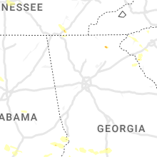
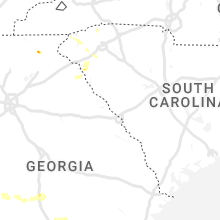
Georgia
| Local Time | Report Details |
|---|---|
| 8:55 AM EDT | Tree down on the 300th block of barwick r in schley county GA, 80.5 miles ESE of Auburn, AL |
| 9:00 AM EDT | Tree reported down near the intersection of andrews ln and mt zion r in schley county GA, 75.7 miles ESE of Auburn, AL |
| 9:05 AM EDT | Tree down near the intersection of heath rd and hw 27 in schley county GA, 77.5 miles ESE of Auburn, AL |
| 11:06 AM EDT | Tree down on powerlines along chambers r in henry county GA, 23.8 miles SSE of Atlanta, GA |
| 11:20 AM EDT | Two downed trees and power lines near the cross section of nichols st. and pine s in clinch county GA, 35.5 miles S of Douglas, GA |
| 11:31 AM EDT | Tree down and power and cable line on ira corbitt rd in lanier count in lanier county GA, 35.6 miles SSW of Douglas, GA |
| 11:48 AM EDT | Power line down near the intersection of flippen rd chip p in henry county GA, 18.9 miles SSE of Atlanta, GA |
| 3:50 PM EDT | Quarter sized hail reported near Helen, GA, 63.7 miles W of Greenville, SC, one inch hail reported near the intersection of hinterstraten weg and rosen strasse. |
Alabama
| Local Time | Report Details |
|---|---|
| 10:00 AM CDT | A tree fell onto power lines and a home... briefly trapping resident in sumter county AL, 68.5 miles WNW of Camden, AL |
| 10:09 AM CDT | Trees and powerlines dow in dale county AL, 76.8 miles S of Auburn, AL |
| 10:09 AM CDT | Trees and powerlines dow in dale county AL, 73.3 miles SSW of Auburn, AL |
| 10:35 AM CDT | Trees and power lines down across road in whitfield. time estimated by rada in sumter county AL, 53.6 miles WNW of Camden, AL |
| 10:55 AM CDT | Several trees down across the count in marengo county AL, 37 miles NW of Camden, AL |
| 1:14 PM CDT | Quarter sized hail reported near Evergreen, AL, 35 miles SSE of Camden, AL, social media video of hail up to quarter size falling. time using radar. |
| 1:29 PM CDT | 911 dispatch reports power lines down on park rd in monroeville. time using rada in monroe county AL, 32.7 miles S of Camden, AL |
| 1:32 PM CDT | Quarter sized hail reported near Evergreen, AL, 36.2 miles SSE of Camden, AL |
| 2:32 PM CDT | Ping Pong Ball sized hail reported near Andalusia, AL, 60.4 miles N of Miramar Beach, FL, report from mping: ping pong ball (1.50 in.). |
| 2:34 PM CDT | Golf Ball sized hail reported near Atmore, AL, 49.8 miles NE of Mobile, AL |
| 2:34 PM CDT | Social media report of lots of trees and debris down along appleton rd. time using rada in conecuh county AL, 50 miles S of Camden, AL |
| 2:40 PM CDT | Tennis Ball sized hail reported near Atmore, AL, 52.2 miles S of Camden, AL |
| 2:58 PM CDT | Ping Pong Ball sized hail reported near Brewton, AL, 53.3 miles S of Camden, AL, social media picture of ping pong hail in barnett crossroads... al. |
| 3:30 PM CDT | Trees down across geneva county... with one reported on a hom in geneva county AL, 54.3 miles NNE of Miramar Beach, FL |
| 3:30 PM CDT | Quarter sized hail reported near Brewton, AL, 60.2 miles SSE of Camden, AL, bm reports quarter hail near t.r douglas high school. time using radar. |
| 3:52 PM CDT | Tree reported down in ashfor in houston county AL, 76.5 miles NW of Tallahassee, FL |
| 4:02 PM CDT | Golf Ball sized hail reported near Brewton, AL, 59.1 miles NW of Miramar Beach, FL, spotter report of golf ball hail in dixonville. time using radar. |
| 4:04 PM CDT | Report from mping: 3-inch tree limbs broken; power poles broke in escambia county AL, 61.7 miles ENE of Mobile, AL |
| 4:05 PM CDT | Quarter sized hail reported near Brewton, AL, 60.2 miles SSE of Camden, AL, report from mping: quarter (1.00 in.). |
Louisiana
| Local Time | Report Details |
|---|---|
| 10:03 AM CDT | Quarter sized hail reported near , , 58.8 miles WSW of Jackson, MS |
| 1:25 AM CDT | Several large limbs and a couple of trees down in blue ridge mobile home park on buncombe road in shreveport. one street blocke in caddo county LA, 11 miles SW of Shreveport, LA |
| 1:25 AM CDT | Widespread trees and power lines down in the blanchard are in caddo county LA, 9.5 miles WNW of Shreveport, LA |
| 1:26 AM CDT | A 70 mph wind gust was recorded at shreveport regional airport aso in caddo county LA, 6.6 miles SW of Shreveport, LA |
| 1:29 AM CDT | Shreveport downtown airport asos recorded a 66 mph wind gus in bossier county LA, 1.8 miles NNE of Shreveport, LA |
| 1:30 AM CDT | Widespread trees down across the city of shreveport and caddo paris in caddo county LA, 4.3 miles SW of Shreveport, LA |
| 1:32 AM CDT | At least several large pines trees were snapped on ferry creek drive in the ellerbe woods subdivison of southeast shreveport. power is out to the area as well. winds we in caddo county LA, 9.4 miles S of Shreveport, LA |
| 1:35 AM CDT | Lots of trees and power lines down in the southern loop and ellerbe areas. tree down blocking ellerbe road at the flournoy lucas intersection. tree down on norris ferry in caddo county LA, 10.2 miles SSE of Shreveport, LA |
| 1:45 AM CDT | Numerous trees down in the long lake subdvision... including a couple trees on a home on chardonnay circl in caddo county LA, 11 miles SSE of Shreveport, LA |
| 1:45 AM CDT | A wind gust of 80 mph was measured at a union pacific railroad weather mesonet station along highway 1 near the port of caddo-bossie in caddo county LA, 11.2 miles SSE of Shreveport, LA |
| 1:45 AM CDT | Barksdale afb asos in bossier city recorded a gust of 67 mp in bossier county LA, 5.2 miles E of Shreveport, LA |
| 1:54 AM CDT | Public sent photo to our social media page of a downed gas station canopy near the intersection of mcarthur drive and polk street in mansfield... l in de soto county LA, 32.9 miles S of Shreveport, LA |
| 2:05 AM CDT | Correction: widespread downed trees in doyline community. also... a report of entrapment at a residence with a tree on the hom in webster county LA, 19.7 miles E of Shreveport, LA |
| 2:05 AM CDT | Numerous trees and power lines down in the dixie inn communit in webster county LA, 24.5 miles ENE of Shreveport, LA |
| 2:10 AM CDT | Widespread trees down in the sibley communit in webster county LA, 26.2 miles E of Shreveport, LA |
| 2:30 AM CDT | Several trees down across the southern portions of webster parish... with multiple roads blocke in webster county LA, 28.8 miles E of Shreveport, LA |
| 3:10 AM CDT | Tree on a vehicle on hwy 167 south of bernice. no injuries... but the driver was trappe in union county LA, 43.4 miles W of Bastrop, LA |
| 3:25 AM CDT | Numerous trees and power lines down in the downsville community area in union parish. many trees across several roadway in union county LA, 30.6 miles WSW of Bastrop, LA |
| 3:25 AM CDT | Tree down on highway 151 near fawn drive close to the union and ouachita lin in union county LA, 30.8 miles WSW of Bastrop, LA |
| 3:28 AM CDT | A large tree snapped and fell on power lines on pine ridge road in west monro in ouachita county LA, 25.5 miles SW of Bastrop, LA |
| 3:30 AM CDT | A large tree down across highway 15 near arthur mcdaniel road near downsvill in union county LA, 27.6 miles WSW of Bastrop, LA |
| 3:30 AM CDT | Tree down on scotts hideaway road near lake darbonne state par in union county LA, 31.1 miles W of Bastrop, LA |
| 3:32 AM CDT | Trees down on power lines on north 3rd street in monro in ouachita county LA, 22 miles SSW of Bastrop, LA |
| 3:35 AM CDT | Numerous trees and power lines down in the point community area in union parish. many trees across several roadway in union county LA, 22.8 miles WSW of Bastrop, LA |
| 4:33 AM CDT | Private weather station at tallulah airpor in madison county LA, 51 miles ESE of Bastrop, LA |
| 4:40 AM CDT | Measured at the tvr airport aso in madison county LA, 49.2 miles W of Jackson, MS |
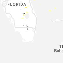
Florida
| Local Time | Report Details |
|---|---|
| 11:30 AM EDT | Powerlines down across hwy 145 in madison tree down in madiso in madison county FL, 52 miles E of Tallahassee, FL |
| 11:35 AM EDT | There are multiple downed trees and power lines across madison count in madison county FL, 54.8 miles E of Tallahassee, FL |
| 11:45 AM EDT | Ping Pong Ball sized hail reported near Jennings, FL, 67 miles SSW of Douglas, GA, ping pong ball size hail reported and relayed to nws employee on northwest county road 152. |
| 2:42 PM EDT | Corrects previous tstm wnd gst report from 1 nne saint augustine beach. mesonet station sauf1 1 nne saint augustine beac in st. johns county FL, 39.9 miles SE of Jacksonville, FL |
| 3:25 PM EDT | 10 to 12 inch tree fell onto i-295 blocking right lane just before exit 25. time estimated by rada in duval county FL, 7.1 miles WNW of Jacksonville, FL |
| 4:13 PM EDT | 2271 thompson valley rd in jefferson county tree blocking roa in jefferson county FL, 25.8 miles E of Tallahassee, FL |
| 5:00 PM EDT | Tree reported down in econfin in taylor county FL, 33 miles SE of Tallahassee, FL |
| 5:15 PM CDT | Tree down along i-10 in north walton count in walton county FL, 24.5 miles N of Miramar Beach, FL |
| 6:45 PM EDT | Emergency manager reports roof torn off of windixie with water coming into the building. also... reports power lines dow in okeechobee county FL, 29.1 miles W of Port Saint Lucie, FL |
| 7:53 PM EDT | Tree damage near oslo rd and 27th ave in indian river county FL, 21.9 miles N of Port Saint Lucie, FL |
| 7:55 PM EDT | The asos at vero beach regional airport (kvrb) measured a wind gust of 58kt/67mph from the southwes in indian river county FL, 26.7 miles N of Port Saint Lucie, FL |
| 7:55 PM EDT | Delayed report. received pictures via social media of one or two large tree branches down in the front yard of a home near the intersection of 14th st sw and 23rd ave s in indian river county FL, 21.3 miles N of Port Saint Lucie, FL |
| 8:00 PM EDT | Road closure on sr-a1a in the pelican island national wildlife preserve due to powerlines down blocking the roadwa in indian river county FL, 37.1 miles N of Port Saint Lucie, FL |
| 7:30 PM CDT | Fswn choctaw beach weatherstem station recorded a max wind gust of 50 kt in gmz636 county FL, 6.8 miles NNE of Miramar Beach, FL |
| 7:40 PM CDT | Ambient weather station measured a 67 mph gus in walton county FL, 4.3 miles NE of Miramar Beach, FL |
| 8:55 PM CDT | Fair point light recorded a max wind gust of 56 knot in gmz634 county FL, 50.7 miles W of Miramar Beach, FL |
| 10:38 PM EDT | A tree was blown down near the intersection of ivan church road and bridle gate d in wakulla county FL, 17.4 miles SSW of Tallahassee, FL |
Colorado
| Local Time | Report Details |
|---|---|
| 12:07 PM MDT | Tennis Ball sized hail reported near Las Animas, CO, 80.4 miles E of Pueblo, CO |
| 4:22 PM MDT | Mesonet station co098 139s034 douglas pas in garfield county CO, 39.1 miles NNW of Grand Junction, CO |
| 6:49 PM MDT | Mesonet station fw3775 montros in montrose county CO, 49.3 miles SE of Grand Junction, CO |
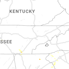
Tennessee
| Local Time | Report Details |
|---|---|
| 1:27 PM CDT | Wires down on i-65. time approximated from rada in williamson county TN, 22.8 miles S of Nashville, TN |
| 1:30 PM CDT | Tree down near stillcreek drive and benmore drive in franklin via #tspotter on twitte in williamson county TN, 19.7 miles SSW of Nashville, TN |
| 1:30 PM CDT | Trees down in the sullivan farms area in franklin via #tspotter on twitte in williamson county TN, 19.8 miles SSW of Nashville, TN |
| 2:00 PM CDT | Oak tree snapped near arno allisona road and giles hill road via #tspotter on twitter. time approximated from rada in williamson county TN, 28.3 miles S of Nashville, TN |
| 2:05 PM CDT | Tree down along flat creek road via #tspotter on twitter. time approximated from rada in williamson county TN, 30.4 miles S of Nashville, TN |
| 3:12 PM EDT | A couple trees reported down on powerline in hamilton county TN, 12 miles NNE of Chattanooga, TN |
| 3:50 PM EDT | A few trees down in and around ooltewa in hamilton county TN, 12.5 miles E of Chattanooga, TN |
| 3:55 PM EDT | Quarter sized hail reported near Ooltewah, TN, 12.5 miles E of Chattanooga, TN, hail video on twitter. |
| 4:25 PM CDT | Em reports power line fallen onto vehicle at ada and palmer road just off buffalo road in lawrencebur in lawrence county TN, 36.4 miles NNE of Florence, AL |
| 4:30 PM CDT | Em reports tree fallen onto a home in the 600 block of old florence pulaski roa in lawrence county TN, 34.3 miles NE of Florence, AL |
Kansas
| Local Time | Report Details |
|---|---|
| 1:16 PM MDT | Golf Ball sized hail reported near Syracuse, KS, 60.3 miles WSW of Garden City, KS |
| 2:35 PM CDT | Golf Ball sized hail reported near Ulysses, KS, 43.6 miles SW of Garden City, KS |
| 2:40 PM CDT | Ping Pong Ball sized hail reported near Ulysses, KS, 37.3 miles SW of Garden City, KS |
| 3:15 PM CDT | Golf Ball sized hail reported near Ulysses, KS, 32.7 miles SW of Garden City, KS |
| 4:15 PM CDT | Reported at hugoton airpor in stevens county KS, 62.1 miles SSW of Garden City, KS |
| 4:30 PM CDT | Sauk1 mesone in seward county KS, 46.2 miles S of Garden City, KS |
| 4:35 PM CDT | Awos station k19s 1 ne sublett in haskell county KS, 32.4 miles S of Garden City, KS |
| 4:45 PM CDT | Storm damage reported in seward county KS, 53.9 miles S of Garden City, KS |
| 4:50 PM CDT | Storm damage reported in seward county KS, 61.4 miles S of Garden City, KS |
| 4:58 PM CDT | Storm damage reported in meade county KS, 50.8 miles SSE of Garden City, KS |
| 5:19 PM CDT | Storm damage reported in meade county KS, 55.8 miles SSE of Garden City, KS |
| 5:32 PM CDT | Storm damage reported in meade county KS, 54.9 miles SE of Garden City, KS |
| 5:39 PM CDT | Asos station kddc dodge city regional airpor in ford county KS, 51.2 miles ESE of Garden City, KS |
| 7:16 PM CDT | Reported at medicine lodge airpor in barber county KS, 72.7 miles WSW of Wichita, KS |
Utah
| Local Time | Report Details |
|---|---|
| 1:42 PM MDT | Quarter sized hail reported near Beryl, UT, 41.6 miles N of Saint George, UT, photos from fire chief show an accumulation of hail with multiple hail sizes. |
| 4:30 PM MDT | Asos station kcny 16 nw moa in grand county UT, 67.6 miles WSW of Grand Junction, CO |
Oklahoma
| Local Time | Report Details |
|---|---|
| 2:48 PM CDT | Half Dollar sized hail reported near Granite, OK, 54.6 miles NE of Childress, TX, report from mping: half dollar (1.25 in.). |
| 3:05 PM CDT | Quarter sized hail reported near Granite, OK, 58.9 miles NE of Childress, TX, report from mping: quarter (1.00 in.). |
| 3:10 PM CDT | Half Dollar sized hail reported near Lone Wolf, OK, 63.3 miles NE of Childress, TX |
| 3:12 PM CDT | Half Dollar sized hail reported near Granite, OK, 60.3 miles NE of Childress, TX |
| 3:33 PM CDT | Golf Ball sized hail reported near Lone Wolf, OK, 67.4 miles NE of Childress, TX |
| 3:37 PM CDT | Baseball sized hail reported near Roosevelt, OK, 71.4 miles ENE of Childress, TX, report from mping: baseball (2.75 in.). |
| 3:57 PM CDT | Hen Egg sized hail reported near Hooker, OK, 85.4 miles SSW of Garden City, KS, public sent in an image. |
| 3:57 PM CDT | Tennis Ball sized hail reported near Hooker, OK, 79.4 miles SSW of Garden City, KS, estimated between 2 to 2.5 in hail. |
| 4:03 PM CDT | Half Dollar sized hail reported near Lawton, OK, 61.8 miles N of Wichita Falls, TX, spotter network report. |
| 4:12 PM CDT | Half Dollar sized hail reported near Lawton, OK, 60.1 miles N of Wichita Falls, TX, report from mping: half dollar (1.25 in.). |
| 4:26 PM CDT | Golf Ball sized hail reported near Fort Sill, OK, 56 miles N of Wichita Falls, TX, ongoing at time of report. |
| 4:33 PM CDT | Tennis Ball sized hail reported near Fort Sill, OK, 52.1 miles N of Wichita Falls, TX |
| 4:34 PM CDT | Baseball sized hail reported near Lawton, OK, 55.6 miles N of Wichita Falls, TX |
| 4:40 PM CDT | Tree damage reported in lawto in comanche county OK, 47.2 miles N of Wichita Falls, TX |
| 4:45 PM CDT | Tea Cup sized hail reported near Fort Sill, OK, 52.3 miles N of Wichita Falls, TX, report from mping: tea cup (3.00 in.). |
| 4:46 PM CDT | Golf Ball sized hail reported near Lawton, OK, 50.9 miles NNE of Wichita Falls, TX |
| 4:57 PM CDT | Golf Ball sized hail reported near Cache, OK, 48.2 miles N of Wichita Falls, TX |
| 5:00 PM CDT | Grapefruit sized hail reported near Lawton, OK, 48.8 miles N of Wichita Falls, TX, twitter image. |
| 5:01 PM CDT | Quarter sized hail reported near Duncan, OK, 52.3 miles NE of Wichita Falls, TX |
| 5:01 PM CDT | Golf Ball sized hail reported near Balko, OK, 86.6 miles W of Woodward, OK, via spotternetwork.org-measured 1.85 hail stone at this location. |
| 5:19 PM CDT | Roof off of house per storm chase in cotton county OK, 31.3 miles N of Wichita Falls, TX |
| 5:20 PM CDT | Storm damage reported in cotton county OK, 33.7 miles NNE of Wichita Falls, TX |
| 5:20 PM CDT | Storm damage reported in beaver county OK, 49.3 miles WNW of Woodward, OK |
| 5:26 PM CDT | Power poles snappe in cotton county OK, 32.3 miles NNE of Wichita Falls, TX |
| 5:36 PM CDT | Golf Ball sized hail reported near Beaver, OK, 63 miles W of Woodward, OK, ping pong to golf ball hail. person was blown off the road 3 time. |
| 6:05 PM CDT | Storm damage reported in jefferson county OK, 34.4 miles ENE of Wichita Falls, TX |
| 7:04 PM CDT | Report from mping: 3-inch tree limbs broken; power poles broke in jefferson county OK, 41.7 miles ENE of Wichita Falls, TX |
| 7:12 PM CDT | Storm damage reported in woodward county OK, 1.1 miles ENE of Woodward, OK |
| 7:13 PM CDT | Several trees down in the town of burneyville. time estimated by rada in love county OK, 70.2 miles E of Wichita Falls, TX |
| 7:17 PM CDT | Hen Egg sized hail reported near Reydon, OK, 57.8 miles SSW of Woodward, OK |
| 7:20 PM CDT | Report from mping: trees uprooted or snapped; roof blown of in love county OK, 63.1 miles E of Wichita Falls, TX |
| 7:26 PM CDT | Powerlines down in mariett in love county OK, 64.6 miles WSW of Atoka, OK |
| 7:30 PM CDT | Ping Pong Ball sized hail reported near Hinton, OK, 46.9 miles W of Oklahoma City, OK |
| 7:30 PM CDT | Storm damage reported in woodward county OK, 27.4 miles SE of Woodward, OK |
| 7:46 PM CDT | Hen Egg sized hail reported near Sayre, OK, 72.7 miles NNE of Childress, TX, report from mping: hen egg (2.00 in.). |
| 7:50 PM CDT | Some trees damaged in the town of fairvie in major county OK, 52.5 miles ESE of Woodward, OK |
| 7:55 PM CDT | Storm damage reported in custer county OK, 58.4 miles S of Woodward, OK |
| 8:05 PM CDT | Storm damage reported in dewey county OK, 43.9 miles SSE of Woodward, OK |
| 8:05 PM CDT | Hen Egg sized hail reported near Sayre, OK, 67.6 miles NNE of Childress, TX |
| 8:10 PM CDT | Semi-trailer flippe in beckham county OK, 65.8 miles NNE of Childress, TX |
| 8:11 PM CDT | Storm damage reported in major county OK, 64.7 miles E of Woodward, OK |
| 8:25 PM CDT | Storm damage reported in major county OK, 71.4 miles NNW of Oklahoma City, OK |
| 8:28 PM CDT | Golf Ball sized hail reported near Tuttle, OK, 20.6 miles SW of Oklahoma City, OK |
| 8:30 PM CDT | Quarter sized hail reported near Tuttle, OK, 20.6 miles SW of Oklahoma City, OK |
| 8:49 PM CDT | Golf Ball sized hail reported near Blanchard, OK, 19 miles SW of Oklahoma City, OK, hwy 4 and fox ln. |
| 8:50 PM CDT | Hen Egg sized hail reported near Tuttle, OK, 20.6 miles SW of Oklahoma City, OK, time estimated by radar. |
| 8:53 PM CDT | Golf Ball sized hail reported near Newcastle, OK, 17 miles SSW of Oklahoma City, OK |
| 8:55 PM CDT | Storm damage reported in kiowa county OK, 76.1 miles ENE of Childress, TX |
| 9:00 PM CDT | Storm damage reported in logan county OK, 44.2 miles N of Oklahoma City, OK |
| 9:03 PM CDT | Quarter sized hail reported near Norman, OK, 14.7 miles S of Oklahoma City, OK, report from mping: quarter (1.00 in.). |
| 9:12 PM CDT | Hwy 9 and pen in mcclain county OK, 20.2 miles S of Oklahoma City, OK |
| 9:20 PM CDT | Storm damage reported in cleveland county OK, 15.7 miles SSE of Oklahoma City, OK |
| 9:20 PM CDT | Ping Pong Ball sized hail reported near Hobart, OK, 75.6 miles ENE of Childress, TX |
| 10:30 PM CDT | Tree downed into the main feeder line for hominy knocking power out to the community for 45 minute in osage county OK, 28.9 miles NW of Tulsa, OK |
| 10:40 PM CDT | Storm damage reported in pontotoc county OK, 35.3 miles WNW of Atoka, OK |
| 10:45 PM CDT | Tree on a house in shady dale area along with multiple power poles down. radar estimated tim in love county OK, 68.2 miles WSW of Atoka, OK |
| 10:47 PM CDT | Two semis rolled over on i-35 at mile marker 11. radar estimated tim in love county OK, 67.2 miles WSW of Atoka, OK |
| 10:48 PM CDT | Multiple trees down. radar estimated tim in love county OK, 70.7 miles SW of Atoka, OK |
| 10:48 PM CDT | Two trees down partially in the fast lane of i-35 at mile marker in love county OK, 69.8 miles SW of Atoka, OK |
| 11:04 PM CDT | Quarter sized hail reported near Duncan, OK, 54.2 miles NE of Wichita Falls, TX, report from mping: quarter (1.00 in.). |
| 12:08 AM CDT | Half Dollar sized hail reported near Lone Grove, OK, 66.5 miles WSW of Atoka, OK, report from mping: half dollar (1.25 in.). |
| 12:12 AM CDT | Quarter sized hail reported near Lone Grove, OK, 67 miles WSW of Atoka, OK, report from mping: quarter (1.00 in.). |
| 12:14 AM CDT | Golf Ball sized hail reported near Lone Grove, OK, 66.5 miles WSW of Atoka, OK, report from mping: golf ball (1.75 in.). |
| 12:18 AM CDT | Golf Ball sized hail reported near Lone Grove, OK, 67.2 miles WSW of Atoka, OK |
| 12:23 AM CDT | Half Dollar sized hail reported near Ardmore, OK, 61.1 miles WSW of Atoka, OK, report from mping: half dollar (1.25 in.). |
| 12:34 AM CDT | Quarter sized hail reported near Ardmore, OK, 59.7 miles WSW of Atoka, OK, report from mping: quarter (1.00 in.). |
Vermont
| Local Time | Report Details |
|---|---|
| 4:16 PM EDT | Several trees blown down along route 207. quarter sized hai in franklin county VT, 33.2 miles NNE of Burlington, VT |
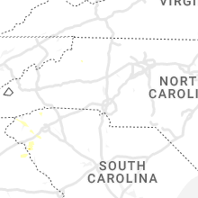
South Carolina
| Local Time | Report Details |
|---|---|
| 4:18 PM EDT | Trees down on power line in oconee county SC, 20.2 miles WNW of Greenville, SC |
| 4:33 PM EDT | A tree and several large branches downed on gap hill roa in pickens county SC, 15.3 miles W of Greenville, SC |
| 4:40 PM EDT | Golf Ball sized hail reported near Six Mile, SC, 13.6 miles W of Greenville, SC |
| 4:40 PM EDT | Numerous trees uprooted or snapped along coveside lane in cove harbor subdivisio in pickens county SC, 15.3 miles W of Greenville, SC |
| 4:44 PM EDT | Social media report of trees down across cedar hill r in pickens county SC, 12.5 miles W of Greenville, SC |
| 4:44 PM EDT | Quarter sized hail reported near Six Mile, SC, 11.9 miles W of Greenville, SC, social media picture of quarter size hail in six mile. |
| 4:49 PM EDT | Social media picture of a large tree down in six mil in pickens county SC, 13.2 miles W of Greenville, SC |
| 5:21 PM EDT | Ping Pong Ball sized hail reported near Liberty, SC, 9.5 miles SSW of Greenville, SC, social media picture of ping pong ball size hail on hwy 88 between pendleton and piedmont. |
| 5:50 PM EDT | Several large trees down. fences and trampolines blow over. kelly farms subdivisio in spartanburg county SC, 33.2 miles E of Greenville, SC |
| 6:02 PM EDT | Several trees dow in anderson county SC, 16.9 miles SSE of Greenville, SC |
| 6:05 PM EDT | Quarter sized hail reported near Williamston, SC, 17.2 miles SSE of Greenville, SC, social media picture of quarter size hail in the williamston area. |
| 6:22 PM EDT | Several trees dow in anderson county SC, 22.2 miles SSE of Greenville, SC |
| 6:42 PM EDT | Quarter sized hail reported near Anderson, SC, 25.3 miles SSW of Greenville, SC, social media report of quarter size hail near the anderson airport. |
| 6:50 PM EDT | Approximately six trees blown down along ashley oaks drive in moor in spartanburg county SC, 32.6 miles E of Greenville, SC |
| 6:50 PM EDT | Corrects time of previous tstm wnd dmg report from 3 w roebuck. several large trees down. fences and trampolines blow over. kelly farms subdivisio in spartanburg county SC, 33.2 miles E of Greenville, SC |
| 6:55 PM EDT | A swath of damaging wind downed numerous trees onto power lines and utility equipment across roebuck and southern spartanbur in spartanburg county SC, 37.7 miles E of Greenville, SC |
| 7:01 PM EDT | Social media report of trees down on the east side of spartanburg near hwy 17 in spartanburg county SC, 40.9 miles E of Greenville, SC |
| 7:37 PM EDT | Several trees dow in anderson county SC, 36.1 miles S of Greenville, SC |
Michigan
| Local Time | Report Details |
|---|---|
| 4:29 PM EDT | Quarter sized hail reported near Webberville, MI, 39.1 miles SW of Flint, MI, public report relayed via wlns tv. |
| 4:50 PM EDT | Quarter sized hail reported near Dexter, MI, 47.2 miles SSW of Flint, MI |
| 4:53 PM EDT | Quarter sized hail reported near Fowlerville, MI, 31.1 miles SW of Flint, MI, hail lasted for 20 minutes. |
| 4:56 PM EDT | Quarter sized hail reported near Howell, MI, 34.3 miles SSW of Flint, MI, hail fell near the intersection of county farm road and blossom farm drive. |
| 4:58 PM EDT | Half Dollar sized hail reported near Dexter, MI, 45.6 miles SSW of Flint, MI |
| 5:02 PM EDT | Quarter sized hail reported near Brighton, MI, 34.3 miles SSW of Flint, MI, nickel to quarter size hail fell near intersection of chilson and brighton rd. |
| 5:10 PM EDT | Ping Pong Ball sized hail reported near Pinckney, MI, 41 miles SSW of Flint, MI, hail fell in downtown pinckney |
| 5:17 PM EDT | Quarter sized hail reported near Ypsilanti, MI, 55.3 miles S of Flint, MI, hail fell near the intersection of us-23 and michigan avenue. |
| 5:20 PM EDT | Quarter sized hail reported near Milan, MI, 59.4 miles S of Flint, MI, hail near the intersection of willis and stoney creek roads. |
| 5:24 PM EDT | Golf Ball sized hail reported near Ann Arbor, MI, 46.4 miles S of Flint, MI, near the intersection of joy and dixboro roads |
| 5:25 PM EDT | Quarter sized hail reported near Ypsilanti, MI, 60.3 miles S of Flint, MI, hail fell near the intersection of willis road and jedd road in augusta charter township. |
| 5:30 PM EDT | Quarter sized hail reported near Ann Arbor, MI, 49.8 miles S of Flint, MI |
| 5:36 PM EDT | Quarter sized hail reported near Canton, MI, 47.2 miles S of Flint, MI, reported at the intersection of beck and warren roads |
| 5:45 PM EDT | Ping Pong Ball sized hail reported near Northville, MI, 42.9 miles S of Flint, MI, picture of ping pong ball hail on social media. |
| 6:02 PM EDT | Quarter sized hail reported near Erie, MI, 86.9 miles S of Flint, MI, penny to quarsize hail. |
| 6:10 PM EDT | Golf Ball sized hail reported near Erie, MI, 86.9 miles S of Flint, MI |
| 6:10 PM EDT | Trees and powerlines dow in monroe county MI, 85.7 miles S of Flint, MI |
| 6:17 PM EDT | Quarter sized hail reported near Ypsilanti, MI, 54.8 miles S of Flint, MI, hail fell at the intersection of s grove st and s harris rd. |
| 6:30 PM EDT | Half Dollar sized hail reported near Belleville, MI, 56.9 miles S of Flint, MI, picture of half dollar size hail on social media. |
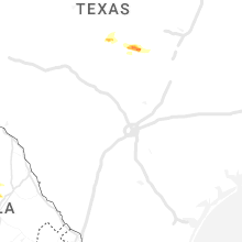
Texas
| Local Time | Report Details |
|---|---|
| 4:20 PM CDT | Half Dollar sized hail reported near Fredonia, TX, 72.8 miles W of Killeen, TX |
| 4:51 PM CDT | Quarter sized hail reported near Perryton, TX, 78.7 miles W of Woodward, OK, via spotternetwork.org. |
| 5:20 PM CDT | Half Dollar sized hail reported near San Saba, TX, 59.3 miles W of Killeen, TX |
| 6:21 PM CDT | Golf Ball sized hail reported near Canadian, TX, 64.3 miles SW of Woodward, OK, via spotternetwork.org. |
| 6:32 PM CDT | Hen Egg sized hail reported near Higgins, TX, 41.3 miles WSW of Woodward, OK |
| 6:33 PM CDT | Quarter sized hail reported near Electra, TX, 19.8 miles W of Wichita Falls, TX |
| 6:36 PM CDT | Tennis Ball sized hail reported near Canadian, TX, 44.1 miles SW of Woodward, OK |
| 6:58 PM CDT | Quarter sized hail reported near Tow, TX, 46.8 miles WSW of Killeen, TX, quarter size hail in tow. |
| 7:05 PM CDT | Golf Ball sized hail reported near Gainesville, TX, 73 miles NNW of Dallas, TX, em reported golfball size hail at west moss lake. time estimated by radar. |
| 7:17 PM CDT | Quarter sized hail reported near Burnet, TX, 43.6 miles WSW of Killeen, TX, quarter size hail near lake buchanan. |
| 7:24 PM CDT | Quarter sized hail reported near Burnet, TX, 42.5 miles SW of Killeen, TX, twitter pic of quarter size hail four miles west of burnet. |
| 7:29 PM CDT | Quarter sized hail reported near Burnet, TX, 38.7 miles SW of Killeen, TX, quarter size hail in burnet. |
| 7:30 PM CDT | Quarter sized hail reported near Burnet, TX, 38.7 miles SW of Killeen, TX, trained spotter reports quarter size hail in downtown burnet. time estimated from radar. |
| 7:31 PM CDT | Half Dollar sized hail reported near Burnet, TX, 38.2 miles SW of Killeen, TX, report from mping half dollar. |
| 7:50 PM CDT | Roof off building and power lines down just east of grand avenue on us-82 in gainesville. time estimated by rada in cooke county TX, 62.5 miles NNW of Dallas, TX |
| 8:27 PM CDT | Quarter sized hail reported near Ringgold, TX, 32.9 miles ESE of Wichita Falls, TX, quarter size hail reported in ringgold by vfd. |
| 8:39 PM CDT | Quarter sized hail reported near Whitesboro, TX, 64.3 miles SW of Atoka, OK, quarter size hail reported 8 miles north of callisburg. |
| 8:49 PM CDT | Ping Pong Ball sized hail reported near Whitesboro, TX, 58 miles N of Dallas, TX, fire chief reports ping pong size hail on old southmayd road south of highway 56. time estimated by radar. |
| 8:53 PM CDT | Power lines down on highway 56 in southmayd. time estimated by rada in grayson county TX, 58.7 miles N of Dallas, TX |
| 9:04 PM CDT | Quarter sized hail reported near Sadler, TX, 62.3 miles N of Dallas, TX, ham reports quarter size hail 1 mile west of sadler... 1 mile north of 82. |
| 9:15 PM CDT | Gainesville asos reports 66kt/76mph wind gus in cooke county TX, 64.5 miles NNW of Dallas, TX |
| 9:31 PM CDT | Em reports 2ft tree down on house west of fm1417 in sherman. time estimated by rada in grayson county TX, 56.1 miles N of Dallas, TX |
| 9:31 PM CDT | Corrects previous tstm wnd dmg report from sherman. emergency manager reports 12in tree branches down in the city of sherman. time estimated by rada in grayson county TX, 59 miles N of Dallas, TX |
| 9:36 PM CDT | Golf Ball sized hail reported near Van Alstyne, TX, 48.2 miles NNE of Dallas, TX, emergency manager reports golfball size hail between howe and van alstyne... tx. |
| 9:40 PM CDT | Emergency manager reports tree fell through the roof of an rv at the savoy rv park. time estimated by rada in fannin county TX, 54.8 miles SSW of Atoka, OK |
| 9:44 PM CDT | Em reports downed tree... structure fire... and pump station power lost in anna. time estimated by rada in collin county TX, 41.9 miles NNE of Dallas, TX |
| 9:45 PM CDT | Golf Ball sized hail reported near Van Alstyne, TX, 46.1 miles NNE of Dallas, TX, golf ball size hail reported in van alstyne. time estimated by radar. |
| 9:48 PM CDT | Fire department reports 30in diameter trees down in the 200 block of virginia avenue in whitesboro. time estimated by rada in grayson county TX, 61.1 miles N of Dallas, TX |
| 9:48 PM CDT | Quarter sized hail reported near Muenster, TX, 64.7 miles ESE of Wichita Falls, TX, quarter size hail reported 3 miles nw of muenster. |
| 9:53 PM CDT | Tea Cup sized hail reported near Sanger, TX, 47.7 miles NNW of Dallas, TX, social media and ham report of 3 inch hail nw of sanger. time estimated by radar. |
| 9:54 PM CDT | Quarter sized hail reported near Sanger, TX, 49.4 miles NNW of Dallas, TX, quarter size hail reported 2 miles north of bolivar. |
| 9:55 PM CDT | Ping Pong Ball sized hail reported near Sanger, TX, 49 miles NW of Dallas, TX, ping pong size hail reported 6 miles w of sanger. |
| 9:56 PM CDT | Softball sized hail reported near Sanger, TX, 45.6 miles NNW of Dallas, TX, photo of 5-5.5 inch hail in sanger. time estimated by radar. |
| 9:57 PM CDT | Hen Egg sized hail reported near Sanger, TX, 46.8 miles NNW of Dallas, TX, egg size hail reported on nw side of sanger. time estimated by radar. |
| 9:59 PM CDT | Ping Pong Ball sized hail reported near Sanger, TX, 49.4 miles NNW of Dallas, TX, ping pong size hail reported 2 miles north of bolivar. |
| 10:07 PM CDT | Tennis Ball sized hail reported near Sanger, TX, 46.5 miles NNW of Dallas, TX, tennis ball size hail reported on nw side of sanger near 35 via social media. |
| 10:15 PM CDT | Hen Egg sized hail reported near Blue Ridge, TX, 42.7 miles NNE of Dallas, TX, em reports 2 in hail in blue ridge. |
| 10:47 PM CDT | Quarter sized hail reported near Tioga, TX, 48.2 miles N of Dallas, TX, quarter size hail reported in tioga. time estimated by radar. |
| 10:50 PM CDT | Several trees down and structural damage reported in lavo in collin county TX, 27 miles NE of Dallas, TX |
| 10:52 PM CDT | Em reports 78mph gust measured in lavo in collin county TX, 27 miles NE of Dallas, TX |
| 10:55 PM CDT | Half Dollar sized hail reported near Collinsville, TX, 51.1 miles N of Dallas, TX, report from mping: half dollar (1.25 in.). |
| 11:05 PM CDT | Estimated 80mph wind gust in caddo mill in hunt county TX, 38.5 miles ENE of Dallas, TX |
| 11:30 PM CDT | Golf Ball sized hail reported near Quinlan, TX, 43.5 miles E of Dallas, TX, delayed report: public report of golf ball size near cr-3613 just east of hawk cove. |
| 11:33 PM CDT | Quarter sized hail reported near Quinlan, TX, 39.8 miles ENE of Dallas, TX, em reports quarter size hail in quinlan. |
| 11:43 PM CDT | Half Dollar sized hail reported near Saint Jo, TX, 58.1 miles ESE of Wichita Falls, TX, half dollar size hail. |
| 11:47 PM CDT | Numerous trees and power lines down in the winnsboro area... including some trees on home in wood county TX, 88.4 miles E of Dallas, TX |
| 12:09 AM CDT | Golf Ball sized hail reported near Pilot Point, TX, 43.9 miles NNW of Dallas, TX, golf ball size hail reported in pilot point. |
| 12:10 AM CDT | A 10 x 15 porbable bulding blown over near the intersection of hwy 154 and kelsey road west of gilme in upshur county TX, 75.8 miles WNW of Shreveport, LA |
| 12:15 AM CDT | A 69 mph wind gust was recorded at mount pleasant regional airport (kosa in titus county TX, 81.3 miles WNW of Shreveport, LA |
| 12:20 AM CDT | Reports of multiple trees down and blocking roads in camp county... along with widespread power outage in camp county TX, 78.7 miles WNW of Shreveport, LA |
| 12:21 AM CDT | Quarter sized hail reported near Celina, TX, 38.1 miles N of Dallas, TX, report from mping: quarter (1.00 in.). |
| 12:26 AM CDT | Trees down at intersection of hwy 271 and county road 311 in smith county TX, 73.7 miles W of Shreveport, LA |
| 12:30 AM CDT | Numerous reports of large trees down across upshur count in upshur county TX, 71.7 miles WNW of Shreveport, LA |
| 12:30 AM CDT | Reports of trees on a couple of homes in the town of lone sta in morris county TX, 63.3 miles WNW of Shreveport, LA |
| 12:30 AM CDT | Trees down near the intersection of fm road 16 and county road 3 in smith county TX, 88.7 miles NNW of Lufkin, TX |
| 12:34 AM CDT | Quarter sized hail reported near Mckinney, TX, 32.9 miles NNE of Dallas, TX, report from mping: quarter (1.00 in.). |
| 12:35 AM CDT | Quarter sized hail reported near Mckinney, TX, 26.3 miles NNE of Dallas, TX, report from mping: quarter (1.00 in.). |
| 12:35 AM CDT | Trees down near intersection of hwy 271 and landry lane near the starrville communit in smith county TX, 79.1 miles W of Shreveport, LA |
| 12:41 AM CDT | Hen Egg sized hail reported near Mckinney, TX, 30.3 miles NNE of Dallas, TX, social media report of 2 inch hail in mckinney. |
| 12:45 AM CDT | Longview pd reports widespread snapped trees and utility poles across the cit in gregg county TX, 59.1 miles W of Shreveport, LA |
| 12:45 AM CDT | Trees down near the intersection of fm road 3053 and county road 111 in rusk county TX, 71 miles NNW of Lufkin, TX |
| 12:49 AM CDT | Golf Ball sized hail reported near Princeton, TX, 32 miles NNE of Dallas, TX, public report of golf ball size hail in princeton. |
| 12:50 AM CDT | Trees down near the intersection of state highway 42 and county road 111 in rusk county TX, 68.9 miles W of Shreveport, LA |
| 12:50 AM CDT | Numerous trees and utility poles down in the elderville are in rusk county TX, 57.7 miles W of Shreveport, LA |
| 1:00 AM CDT | Reports of widespread trees down along with widespread power outages in the city of marshal in harrison county TX, 35.2 miles W of Shreveport, LA |
| 1:00 AM CDT | A 63 mph wind gust was recorded at the east texas regional airport in longvie in gregg county TX, 57 miles W of Shreveport, LA |
| 1:03 AM CDT | Quarter sized hail reported near Sherman, TX, 59.5 miles SSW of Atoka, OK, public report of quarter size hail in sherman. |
| 1:15 AM CDT | Reports of two structures with damage in the community of de berr in panola county TX, 28.4 miles WSW of Shreveport, LA |
| 1:16 AM CDT | Several large trees down in the panola area across us highway 7 in panola county TX, 22.7 miles WSW of Shreveport, LA |
| 1:21 AM CDT | Golf Ball sized hail reported near Gordonville, TX, 57.8 miles SW of Atoka, OK, emergency mngr reported golf ball size hail in gordonville. |
| 1:32 AM CDT | Half Dollar sized hail reported near Sadler, TX, 61.3 miles SW of Atoka, OK, public report of half dollar size hail north of sadler. |
| 1:35 AM CDT | A texas water development board mesonet site south of deberry... tx... called nansco farms... recorded a 58 mph wind gus in panola county TX, 30.7 miles SW of Shreveport, LA |
| 1:45 AM CDT | Reports of multiple trees down across panola county... with many trees blocking road in the northern portion of the count in panola county TX, 42.8 miles SW of Shreveport, LA |
| 2:04 AM CDT | Ping Pong Ball sized hail reported near Alba, TX, 67.3 miles E of Dallas, TX, public report of hail near alba via kltv-tv social media page. |
| 2:15 AM CDT | Ping Pong Ball sized hail reported near Mineola, TX, 74.4 miles E of Dallas, TX, hail up to ping pong size reported in the sand springs community between the town of mineola and community of golden. |
| 2:15 AM CDT | Quarter sized hail reported near Ladonia, TX, 65.6 miles NE of Dallas, TX, public report of quarter size hail in ladonia. |
| 2:20 AM CDT | Quarter sized hail reported near Mineola, TX, 76.3 miles E of Dallas, TX |
| 2:22 AM CDT | Ping Pong Ball sized hail reported near Ladonia, TX, 65.6 miles NE of Dallas, TX, upgrade a previous report of quarter to ping pong ball size hail in ladonia. |
| 2:45 AM CDT | Quarter sized hail reported near Caddo Mills, TX, 38.5 miles ENE of Dallas, TX, nickel to quarter size hail in caddo mills. |
| 3:00 AM CDT | Numerous trees and power lines were downed in and around winon in smith county TX, 83.1 miles W of Shreveport, LA |
| 3:09 AM CDT | Ktrl gusted to 55 kts at 0309a in kaufman county TX, 31 miles E of Dallas, TX |
| 3:50 AM CDT | Golf Ball sized hail reported near Van, TX, 66.3 miles ESE of Dallas, TX, media report of golf ball size hail near the van/colfax area. |
| 4:14 AM CDT | Quarter sized hail reported near Brownsboro, TX, 74.7 miles ESE of Dallas, TX, public report of quarter size hail just north of brownsboro. |
| 4:19 AM CDT | Golf Ball sized hail reported near Chandler, TX, 80.3 miles NNW of Lufkin, TX, report of golf ball size hail in chandler. |
| 4:30 AM CDT | Golf Ball sized hail reported near Bullard, TX, 65.7 miles NNW of Lufkin, TX, a picture of golfball size hail that fell near bullard was posted to social media. |
| 4:38 AM CDT | Quarter sized hail reported near Bullard, TX, 60.4 miles NNW of Lufkin, TX, quarter size hail fell in the mt. selman community. |
| 4:48 AM CDT | Golf Ball sized hail reported near Jacksonville, TX, 56.7 miles NW of Lufkin, TX, golfball size hail fell just north of jacksonville. |
| 4:48 AM CDT | Hen Egg sized hail reported near Jacksonville, TX, 57 miles NW of Lufkin, TX, hen egg size hail fell on cr 4120 just northwest of jacksonville. |
| 4:51 AM CDT | Golf Ball sized hail reported near Jacksonville, TX, 54.3 miles NW of Lufkin, TX, a picture was posted to social media of golfball size hail that fell in jacksonville. |
| 5:50 AM CDT | Quarter sized hail reported near Pollok, TX, 11.2 miles NW of Lufkin, TX, quarter size hail fell near pollok. |
| 6:00 AM CDT | A tree was blown down across fm 84 in angelina county TX, 8.3 miles NW of Lufkin, TX |
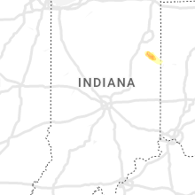
Indiana
| Local Time | Report Details |
|---|---|
| 5:30 PM EDT | Report from mping: 3-inch tree limbs broken; power poles broke in wells county IN, 22.8 miles S of Fort Wayne, IN |
| 5:36 PM EDT | Report relayed from near bluffton along 124... reports of trees down from thunderstorm wind. no information on size/tree healt in wells county IN, 23.2 miles S of Fort Wayne, IN |
| 5:36 PM EDT | Reports of a large tree down on a mobile home in the park off us 124. no injuries or fatalities were reporte in wells county IN, 23.4 miles S of Fort Wayne, IN |
| 5:38 PM EDT | Various 1-3 inch limbs down. reported via mpin in wells county IN, 26.7 miles S of Fort Wayne, IN |
| 5:41 PM EDT | Mping 1 to 3 inch limbs reported down by spotter... also had a phone call about various 1-3 inch diameter limbs and tree debris around tow in wells county IN, 25.3 miles S of Fort Wayne, IN |
| 5:45 PM EDT | Corrects previous tstm wnd dmg report from 1 ssw vera cruz. metal roofing partially removed/peeled off an outhouse building. an empty 35k gallon fertilizer tank was tip in wells county IN, 26.6 miles S of Fort Wayne, IN |
| 5:45 PM EDT | Half Dollar sized hail reported near Bluffton, IN, 27.3 miles S of Fort Wayne, IN, crop damage at 700e and 400s from the large hail that moved through the area. |
| 5:47 PM EDT | Half Dollar sized hail reported near Bluffton, IN, 28.8 miles S of Fort Wayne, IN, hail covering the road like snow... about two inches thick. average size was quarter sized... and then the largest spotter saw was half dollar. there is patchy dense fo |
| 5:47 PM EDT | 24 inch diameter healthy maple uprooted... a grove of trees was heavily damaged... with trees of varying health and size were either uprooted or snappe in adams county IN, 28.8 miles S of Fort Wayne, IN |
| 7:45 PM EDT | Metal roofing partially removed/peeled off an outhouse building. an empty 35k gallon fertilizer tank was tipped over on its sid in wells county IN, 26.6 miles S of Fort Wayne, IN |
Ohio
| Local Time | Report Details |
|---|---|
| 6:07 PM EDT | Multiple utility poles down and report of a roof blown off of a house in washington township. time estimated via rada in lucas county OH, 89.5 miles S of Flint, MI |
| 6:09 PM EDT | Numerous reports of trees snapped and structural damage... including roofs ripped off buildings... in point place. possible tornad in lucas county OH, 90.3 miles S of Flint, MI |
| 6:10 PM EDT | Numerous trees snapped. minor damage to a vehicle reported as well as minor damage to a roof. time estimated via rada in lucas county OH, 90.4 miles S of Flint, MI |
| 6:10 PM EDT | Golf Ball sized hail reported near Oregon, OH, 88.4 miles W of Cleveland, OH, large hail reported in maumee bay state park. time estimated via radar. |
| 6:15 PM EDT | Hen Egg sized hail reported near Toledo, OH, 89.7 miles S of Flint, MI |
| 6:15 PM EDT | Tennis Ball sized hail reported near Toledo, OH, 90.4 miles S of Flint, MI, report from mping: tennis ball (2.50 in.). |
| 6:16 PM EDT | Hen Egg sized hail reported near Toledo, OH, 89.8 miles S of Flint, MI, time estimated via radar. |
| 6:16 PM EDT | Numerous large trees snapped and damage to a building. possible tornado damag in lucas county OH, 89.7 miles S of Flint, MI |
| 6:18 PM EDT | Buoy station thro1 toledo... o in lucas county OH, 91.8 miles S of Flint, MI |
| 6:42 PM EDT | Half Dollar sized hail reported near Oak Harbor, OH, 77 miles W of Cleveland, OH |
| 6:48 PM EDT | Quarter sized hail reported near Oak Harbor, OH, 75.7 miles W of Cleveland, OH, time estimated via radar. |
| 6:50 PM EDT | Damage to multiple houses near hetrick and bloom roads. possible tornado damag in ottawa county OH, 74.7 miles W of Cleveland, OH |
| 6:52 PM EDT | Corrects time on previous report from 6 se oak harbor. emergency manager reported storm damage in rice twp. possible tornad in sandusky county OH, 72.3 miles W of Cleveland, OH |
| 6:57 PM EDT | Several reports of structural damage along and around state route 19 south of oak harbor in ottawa county. damage includes siding damage... outbuilding wall failure. in ottawa county OH, 75.7 miles W of Cleveland, OH |
| 7:18 PM EDT | Multiple trees snapped and powerlines down along the turnpike/i-80. time estimated via rada in sandusky county OH, 70.6 miles W of Cleveland, OH |
| 7:20 PM EDT | Outbuilding destroyed with debris scattered into field near us-6 and county road 298. time estimated via rada in sandusky county OH, 62.7 miles W of Cleveland, OH |
| 7:22 PM EDT | Corrects previous non-tstm wnd dmg report from 2 wsw sandusky. poles snapped along us- in erie county OH, 55.2 miles W of Cleveland, OH |
| 7:27 PM EDT | Barn collapse. time estimated via rada in sandusky county OH, 71.9 miles W of Cleveland, OH |
| 7:27 PM EDT | Numerous trees and powerlines dow in erie county OH, 58.6 miles W of Cleveland, OH |
| 7:29 PM EDT | Ping Pong Ball sized hail reported near Bellevue, OH, 62.7 miles WSW of Cleveland, OH |
| 7:29 PM EDT | Golf Ball sized hail reported near Bellevue, OH, 61.7 miles WSW of Cleveland, OH |
| 7:31 PM EDT | Corrects previous non-tstm wnd dmg report from bellevue. trees snapped along northwest stree in huron county OH, 61.7 miles WSW of Cleveland, OH |
| 7:32 PM EDT | Golf Ball sized hail reported near Bellevue, OH, 61.7 miles WSW of Cleveland, OH, a trained spotter reported golf ball sized hail near sr 269 and lincoln street in bellevue. |
| 7:40 PM EDT | Large trees downed just north of bellevue. time estimated via rada in huron county OH, 61.2 miles WSW of Cleveland, OH |
| 7:49 PM EDT | Quarter sized hail reported near Fostoria, OH, 82 miles N of Columbus, OH, trained spotter reported quarter sized hail in bascom. |
| 7:51 PM EDT | Multiple trees down north of bellevue. report obtained on social media and time estimated via rada in sandusky county OH, 61.7 miles WSW of Cleveland, OH |
| 7:51 PM EDT | Large tree uprooted. time estimated via rada in huron county OH, 54.5 miles WSW of Cleveland, OH |
| 7:52 PM EDT | Half Dollar sized hail reported near Tiffin, OH, 81.2 miles N of Columbus, OH, report from mping: half dollar (1.25 in.). |
| 7:53 PM EDT | Quarter sized hail reported near Tiffin, OH, 80.4 miles N of Columbus, OH |
| 7:53 PM EDT | Damage to houses and outbuildings. numerous trees and powerlines down. possible tornado damage. time estimated via rada in huron county OH, 56.1 miles WSW of Cleveland, OH |
| 7:55 PM EDT | Metal barn partially destroyed on ridge roa in huron county OH, 51.9 miles WSW of Cleveland, OH |
| 8:04 PM EDT | Corrects previous non-tstm wnd dmg report from 3 se north fairfield. house damaged on edward roa in huron county OH, 54.3 miles WSW of Cleveland, OH |
| 8:06 PM EDT | Quarter sized hail reported near Tiffin, OH, 79.8 miles N of Columbus, OH, report from mping: quarter (1.00 in.). |
| 8:32 PM EDT | Several trees dow in miami county OH, 67.4 miles WNW of Columbus, OH |
| 8:32 PM EDT | Golf Ball sized hail reported near Nova, OH, 50.8 miles SW of Cleveland, OH |
| 8:35 PM EDT | Half Dollar sized hail reported near Ashland, OH, 49.5 miles SW of Cleveland, OH, report from mping: half dollar (1.25 in.). |
| 8:37 PM EDT | Hen Egg sized hail reported near Ashland, OH, 51.8 miles SW of Cleveland, OH, picture submitted via social media. |
| 8:46 PM EDT | Ping Pong Ball sized hail reported near West Salem, OH, 43.7 miles SW of Cleveland, OH, time estimated via radar. |
| 8:49 PM EDT | Golf Ball sized hail reported near Ashland, OH, 49.9 miles SW of Cleveland, OH, report from mping: golf ball (1.75 in.). |
| 8:50 PM EDT | Golf Ball sized hail reported near Ashland, OH, 50.3 miles SW of Cleveland, OH |
| 8:50 PM EDT | Numerous trees down along sr 58 between county rd 801 and 85 in ashland county OH, 49.8 miles SW of Cleveland, OH |
| 9:15 PM EDT | Tree dow in madison county OH, 17.5 miles NW of Columbus, OH |
| 9:16 PM EDT | Tree down on south firestone roa in wayne county OH, 52.5 miles SSW of Cleveland, OH |
| 9:20 PM EDT | Tree down on mechanicsburg roa in wayne county OH, 47 miles SSW of Cleveland, OH |
| 9:30 PM EDT | Corrects previous non-tstm wnd dmg report from 2 ese crestline. tree reported down on north horning roa in richland county OH, 58.7 miles NNE of Columbus, OH |
| 9:36 PM EDT | Large tree down on route 3 in richland county OH, 59.8 miles NNE of Columbus, OH |
| 9:49 PM EDT | Emergency management reported storm damage in rice twp. possible tornado. time estimated via rada in sandusky county OH, 72.3 miles W of Cleveland, OH |
| 10:25 PM EDT | Quarter sized hail reported near Dover, OH, 65.5 miles S of Cleveland, OH |
| 10:25 PM EDT | Tree dow in holmes county OH, 65.6 miles NE of Columbus, OH |
| 10:35 PM EDT | Quarter sized hail reported near Port Washington, OH, 78.6 miles S of Cleveland, OH |
| 10:39 PM EDT | Quarter sized hail reported near New Philadelphia, OH, 71.2 miles S of Cleveland, OH |
| 10:40 PM EDT | Quarter sized hail reported near New Philadelphia, OH, 71.2 miles S of Cleveland, OH |
| 10:47 PM EDT | Half Dollar sized hail reported near Gnadenhutten, OH, 74 miles W of Pittsburgh, PA |
| 10:49 PM EDT | Quarter sized hail reported near Gnadenhutten, OH, 75.8 miles W of Pittsburgh, PA |
| 10:55 PM EDT | Quarter sized hail reported near Uhrichsville, OH, 71.4 miles W of Pittsburgh, PA |
| 11:06 PM EDT | Quarter sized hail reported near Thornville, OH, 28 miles E of Columbus, OH, time estimated from radar |
| 11:32 PM EDT | Quarter sized hail reported near Cadiz, OH, 53.7 miles WSW of Pittsburgh, PA |
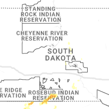
Nebraska
| Local Time | Report Details |
|---|---|
| 6:03 PM CDT | Quarter sized hail reported near Kilgore, NE, 18.9 miles NW of Valentine, NE, mostly smaller hail. |
| 6:04 PM CDT | Old barn roof was blown off by win in todd county SD, 17.4 miles NW of Valentine, NE |
| 6:10 PM CDT | 50-60 mph wind gusts for several minute in todd county SD, 18.6 miles NNW of Valentine, NE |
South Dakota
| Local Time | Report Details |
|---|---|
| 6:25 PM CDT | Storm damage reported in todd county SD, 24.1 miles NNW of Valentine, NE |
Connect with Interactive Hail Maps