

Hail Map for Saturday, June 20, 2015

Number of Impacted Households on 6/20/2015
0
Impacted by 1" or Larger Hail
0
Impacted by 1.75" or Larger Hail
0
Impacted by 2.5" or Larger Hail
Square Miles of Populated Area Impacted on 6/20/2015
0
Impacted by 1" or Larger Hail
0
Impacted by 1.75" or Larger Hail
0
Impacted by 2.5" or Larger Hail


Cities Most Affected by Hail Storms of 6/20/2015
| Hail Size | Demographics of Zip Codes Affected | ||||||
|---|---|---|---|---|---|---|---|
| City | Count | Average | Largest | Pop Density | House Value | Income | Age |
| Harvey, IA | 3 | 3.25 | 4.00 | 24 | $52k | $37.7k | 40.6 |
| Gordon, NE | 4 | 1.75 | 1.75 | 2 | $46k | $28.0k | 45.1 |
| Rushville, NE | 3 | 1.75 | 1.75 | 1 | $43k | $28.7k | 42.9 |
| Newcastle, WY | 2 | 2.13 | 2.50 | 2 | $67k | $32.8k | 42.4 |
| Pella, IA | 2 | 2.13 | 2.50 | 112 | $124k | $47.2k | 34.5 |
| Hot Springs, SD | 2 | 2.13 | 2.50 | 11 | $63k | $30.3k | 50.7 |
| Harvey, ND | 2 | 1.88 | 2.00 | 6 | $49k | $33.4k | 50.7 |
| Oskaloosa, IA | 2 | 1.88 | 2.00 | 92 | $69k | $36.7k | 38.4 |
| Towner, ND | 2 | 1.75 | 1.75 | 1 | $31k | $28.0k | 48.1 |
| Faith, SD | 1 | 1.75 | 1.75 | 0 | $41k | $23.9k | 39.4 |
| Hill City, SD | 1 | 1.75 | 1.75 | 3 | $97k | $36.2k | 47.3 |
| Hannaford, ND | 1 | 1.75 | 1.75 | 2 | $33k | $31.9k | 50.1 |
| Porcupine, SD | 1 | 1.75 | 1.75 | 1 | $36k | $23.0k | 23.6 |
| Ottumwa, IA | 1 | 1.75 | 1.75 | 133 | $51k | $31.9k | 39.1 |
| Dazey, ND | 1 | 1.75 | 1.75 | 2 | $27k | $24.2k | 43.8 |
Hail and Wind Damage Spotted on 6/20/2015
Filter by Report Type:Hail ReportsWind Reports
States Impacted
Iowa, West Virginia, Ohio, Georgia, Wisconsin, North Carolina, Texas, Maryland, Virginia, Pennsylvania, North Dakota, South Carolina, Illinois, Florida, South Dakota, Wyoming, Missouri, Nebraska, Delaware, IndianaIowa
| Local Time | Report Details |
|---|---|
| 10:30 AM CDT | Time estimated. tree branches 6 and 10 inches in diameter blew down. relayed by fire dept via faceboo in buchanan county IA, 34.2 miles N of Cedar Rapids, IA |
| 10:30 AM CDT | Time estimated. tree branches 6 and 10 inches in diameter blew dow in buchanan county IA, 34.2 miles N of Cedar Rapids, IA |
| 11:15 AM CDT | Quarter sized hail reported near Palo, IA, 8 miles NW of Cedar Rapids, IA, hailing so hard it looked like snow. mostly nickle but a few quarters mixed in. hail lasted 3 minutes. |
| 11:18 AM CDT | Quarter sized hail reported near Cedar Rapids, IA, 5.8 miles N of Cedar Rapids, IA, hail up to quarter sized. also heavy rain. |
| 11:20 AM CDT | Half Dollar sized hail reported near Marion, IA, 8.4 miles NNE of Cedar Rapids, IA, hail began as penny sized and at 1120 cdt peaked at half dollar size. |
| 11:23 AM CDT | Quarter sized hail reported near Cedar Rapids, IA, 5.4 miles NNE of Cedar Rapids, IA, brief quarter sized hail. |
| 11:30 AM CDT | Quarter sized hail reported near Springville, IA, 12.9 miles ENE of Cedar Rapids, IA, hail of quarter sized around 1130. hailed for about 10 minutes from about 1125 to 1135. |
| 11:30 AM CDT | Quarter sized hail reported near Marion, IA, 5.7 miles NE of Cedar Rapids, IA, caller will post picture and video on nws quad cities facebook page. |
| 1:35 PM CDT | Quarter sized hail reported near Clarence, IA, 32.2 miles E of Cedar Rapids, IA, dime to quarter sized hail. |
| 1:38 PM CDT | Quarter sized hail reported near Lowden, IA, 39.7 miles ESE of Cedar Rapids, IA, hail lasted 5 to 10 minutes. |
| 1:53 PM CDT | Quarter sized hail reported near Calamus, IA, 48.2 miles ESE of Cedar Rapids, IA, time estimated from radar |
| 2:18 PM CDT | Quarter sized hail reported near Eldridge, IA, 61.5 miles ESE of Cedar Rapids, IA, scott county park |
| 2:35 PM CDT | Quarter sized hail reported near Holy Cross, IA, 55.2 miles NE of Cedar Rapids, IA |
| 4:48 PM CDT | Golf Ball sized hail reported near Pella, IA, 36.9 miles ESE of Des Moines, IA |
| 5:12 PM CDT | Quarter sized hail reported near Hopkinton, IA, 33.2 miles NE of Cedar Rapids, IA, along with 1/2 inch of rain in 5 minutes. |
| 5:20 PM CDT | Tea Cup sized hail reported near Harvey, IA, 40.6 miles ESE of Des Moines, IA, measured 3 to 3.5 inch hail as storm passed over his home around 5:20pm |
| 5:20 PM CDT | Baseball sized hail reported near Harvey, IA, 40.6 miles ESE of Des Moines, IA, time estimated...based on radar. report forwarded from kcci tv. |
| 5:26 PM CDT | Grapefruit sized hail reported near Harvey, IA, 40.6 miles ESE of Des Moines, IA, delayed report from june 20. photos on twitter and on the kcci ulocal page show measured hailstones around 4 inches in diameter. time estimated from radar. |
| 5:35 PM CDT | Tennis Ball sized hail reported near Pella, IA, 38.2 miles ESE of Des Moines, IA, hail size estimated from picture received via social media. |
| 5:50 PM CDT | Hen Egg sized hail reported near Oskaloosa, IA, 54.7 miles ESE of Des Moines, IA, delayed report from june 20. photo from kcci ulocal page shows hail around 2 inches in oskaloosa. |
| 5:55 PM CDT | Golf Ball sized hail reported near Oskaloosa, IA, 55.4 miles ESE of Des Moines, IA, delayed report from june 20. photo from kcci ulocal page |
| 6:15 PM CDT | Report of a roof off a house and numerous trees down in tow in wapello county IA, 62.8 miles NW of Kahoka, MO |
| 6:28 PM CDT | Tree branch fallen on power line via social media...radar estimated time in wapello county IA, 51.8 miles NW of Kahoka, MO |
| 6:30 PM CDT | Spotter reported approximately 60mph wind gusts entering ottumwa in wapello county IA, 55.2 miles NW of Kahoka, MO |
| 6:33 PM CDT | Rwis measured 60mph wind gust in ottumwa within railroad park in wapello county IA, 55.3 miles NW of Kahoka, MO |
| 6:40 PM CDT | Trees down in town in wapello county IA, 43.3 miles NW of Kahoka, MO |
| 6:40 PM CDT | Thunderstorm wind gust estimated at 70 mph. large tree fell on a garag in davis county IA, 45.1 miles NW of Kahoka, MO |
| 6:42 PM CDT | Estimated 60mph wind gusts approximately 4 miles east of agency...relayed by public in wapello county IA, 48.1 miles NNW of Kahoka, MO |
| 6:51 PM CDT | Chaser reports of trees down and debris 2 miles e of ottumwa in wapello county IA, 54 miles NW of Kahoka, MO |
| 6:53 PM CDT | Chaser reported large trees down across roads just north of ottumwa. in wapello county IA, 56.9 miles NW of Kahoka, MO |
| 6:53 PM CDT | Golf Ball sized hail reported near Ottumwa, IA, 56.9 miles NW of Kahoka, MO |
| 6:54 PM CDT | Half Dollar sized hail reported near Ottumwa, IA, 55.3 miles NW of Kahoka, MO, public reported half dollar/1.25" hail in ottumwa...along with numerous large tree branches down. |
| 6:55 PM CDT | Storm damage reported in jefferson county IA, 42.7 miles NNW of Kahoka, MO |
| 7:09 PM CDT | 60+ mph winds with cornfield laid ove in jefferson county IA, 51 miles N of Kahoka, MO |
| 7:13 PM CDT | Significant tree and sign damage near mile marker 229 on hwy 34. time estimated from radar and report via twitte in henry county IA, 38.2 miles NNE of Kahoka, MO |
| 7:14 PM CDT | Several trees snapped at the base. tree limbs on ia 1 in lee county IA, 25 miles N of Kahoka, MO |
| 7:17 PM CDT | Several trees a foot in diameter snapped...time estimated from rada in henry county IA, 38.2 miles NNE of Kahoka, MO |
| 7:25 PM CDT | 60 mph wind knocked down a tre in van buren county IA, 15.2 miles N of Kahoka, MO |
| 7:26 PM CDT | Large tree limb snapped at mile marker 252 on hwy 34. tree limb was about 24 inches in diameter. time estimated from rada in des moines county IA, 37.2 miles NE of Kahoka, MO |
| 7:32 PM CDT | Numerous tree damage...camper on its side...and a telephone pole down. time estimated from rada in lee county IA, 30.6 miles NE of Kahoka, MO |
| 7:35 PM CDT | Camping trailer blown off jacks. corn blown over. heavy rai in lee county IA, 30.6 miles NE of Kahoka, MO |
| 7:37 PM CDT | Time estimated from rada in des moines county IA, 46.9 miles NE of Kahoka, MO |
| 7:38 PM CDT | Very large trees down near 2200 block of isabella and a dumpster was in the road near sunnyside and rosevelt street in des moines county IA, 42.7 miles NE of Kahoka, MO |
| 7:39 PM CDT | Storm damage reported in des moines county IA, 39.5 miles NE of Kahoka, MO |
| 7:41 PM CDT | Significant tree and sign damage near mile marker 229 on u.s. highway 34 west of mt. pleasan in henry county IA, 38.2 miles NNE of Kahoka, MO |
| 7:45 PM CDT | Several 3 to 6 inch tree limbs dow in lee county IA, 25.5 miles NE of Kahoka, MO |
| 7:45 PM CDT | Multiple 3 inch tree limbs down. winds estimated 70 mph. water in street is curb dee in des moines county IA, 39.5 miles NE of Kahoka, MO |
| 7:51 PM CDT | Large trees down in road in des moines county IA, 39.5 miles NE of Kahoka, MO |
| 8:02 PM CDT | 12 inch diameter trees blown down on north side of town. power ou in des moines county IA, 50.2 miles NE of Kahoka, MO |
West Virginia
| Local Time | Report Details |
|---|---|
| 1:50 PM EDT | Trees and power lines down. power ou in gilmer county WV, 48.8 miles W of Elkins, WV |
| 1:52 PM EDT | Tree down on trailer in gilmer county WV, 47.3 miles W of Elkins, WV |
| 2:00 PM EDT | Power lines and trees down. power out in lewis county WV, 36.9 miles W of Elkins, WV |
| 2:25 PM EDT | Numerous trees and branches down... estimated gust of 60mph in lewis county WV, 30 miles WNW of Elkins, WV |
| 2:29 PM EDT | Tree down in harrison county WV, 35.8 miles WNW of Elkins, WV |
| 2:35 PM EDT | Numerous tree branches and limbs down in harrison county WV, 36.5 miles NW of Elkins, WV |
| 2:44 PM EDT | Power lines down. power out in harrison county WV, 35.8 miles NW of Elkins, WV |
| 2:55 PM EDT | Trees and power lines down in quiet dell... time estimated from radar in harrison county WV, 31.5 miles NW of Elkins, WV |
| 3:00 PM EDT | Numerous trees down in the town of monongah...on boothes creek r in marion county WV, 40.9 miles NNW of Elkins, WV |
| 3:00 PM EDT | Trees down on power lines 200 yards west of intersection of 119 and 57 in barbour county WV, 19.4 miles NW of Elkins, WV |
| 3:05 PM EDT | Large tree fell on a vehicle on coutry club rd in fairmont in marion county WV, 41.7 miles NNW of Elkins, WV |
| 3:10 PM EDT | A few trees blown down in grafton in taylor county WV, 30.2 miles NNW of Elkins, WV |
| 3:15 PM EDT | Trees down along wilsonburg and davisson run roads near wilsonburg. relayed via media. time estimate in harrison county WV, 38.8 miles NW of Elkins, WV |
| 3:25 PM EDT | Trees down in monongalia county WV, 47.2 miles N of Elkins, WV |
| 3:40 PM EDT | Trees down on north preston highway in preston county WV, 40.6 miles NNE of Elkins, WV |
| 4:30 PM EDT | Two trees down along u.s. 50 near dolan dr in hampshire county WV, 69.2 miles ENE of Elkins, WV |
| 5:04 PM EDT | Metal road sign blown into middle of north main street in hardy county WV, 48.1 miles ENE of Elkins, WV |
| 5:04 PM EDT | Top half of an apple tree snapped off near residence in hardy county WV, 48.1 miles ENE of Elkins, WV |
| 5:27 PM EDT | Tree down on upper skaggs run rd in hardy county WV, 56.5 miles ENE of Elkins, WV |
Ohio
| Local Time | Report Details |
|---|---|
| 1:50 PM EDT | Trees down...roof damage...and chimney damag in perry county OH, 48.7 miles ESE of Columbus, OH |
| 2:25 PM EDT | Reported damage to a home on tullis rd near wayne national forest. per wesley ohio fire chief. time est from radar in washington county OH, 73.2 miles ESE of Columbus, OH |
| 3:04 PM EDT | Three trees down in noble county OH, 85.9 miles SW of Pittsburgh, PA |
| 3:10 PM EDT | Reported damage to a home on tullis road near wayne national forest per the wesley oh fire chie in washington county OH, 73.2 miles ESE of Columbus, OH |
Georgia
| Local Time | Report Details |
|---|---|
| 2:57 PM EDT | A tree was blown down on habersham drive near john ward r in cobb county GA, 17.7 miles NW of Atlanta, GA |
| 2:58 PM EDT | A tree was blown down at the intersection of the east-west connector and hicks r in cobb county GA, 13.3 miles NW of Atlanta, GA |
Wisconsin
| Local Time | Report Details |
|---|---|
| 2:19 PM CDT | Quarter sized hail reported near Cross Plains, WI, 16 miles W of Madison, WI, time estimated from radar. |
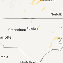
North Carolina
| Local Time | Report Details |
|---|---|
| 3:52 PM EDT | Tree down on car on 4800 block of cherry road in beaufort county NC, 92.8 miles E of Raleigh, NC |
| 4:05 PM EDT | A tree down along hwy-17 just south of aurora rd in craven county NC, 83.3 miles NE of Wilmington, NC |
| 4:05 PM EDT | Quarter sized hail reported near Williamston, NC, 88.5 miles E of Raleigh, NC, mix of dime to quarter size hail along hwy-17 |
| 4:20 PM EDT | Quarter sized hail reported near Jamesville, NC, 86 miles SW of Virginia Beach, VA, quarter size hail along hwy-117 south of jamesville |
| 4:20 PM EDT | Powerlines down on dallas high shoals road in gaston county NC, 22.6 miles WNW of Charlotte, NC |
| 4:24 PM EDT | Trees down at the intersection of hope ct and jenny dr in the patterson springs community in cleveland county NC, 37.5 miles W of Charlotte, NC |
| 4:45 PM EDT | *** 1 fatal *** a 43 year old female postal employee died when a large tree fell on her postal service vehicle on norman court off lakeshore roa in lincoln county NC, 21.4 miles NNW of Charlotte, NC |
| 4:55 PM EDT | Tree down on broadbill dr near mooresville in iredell county NC, 23.4 miles N of Charlotte, NC |
| 5:05 PM EDT | Spotter reports multiple trees down near concord in cabarrus county NC, 15.4 miles NNE of Charlotte, NC |
| 5:05 PM EDT | Trees reported down on shearers rd south of mooresville in iredell county NC, 22.7 miles N of Charlotte, NC |
| 5:07 PM EDT | Tree reported down in kannapolis. time estimated from radar in cabarrus county NC, 22.4 miles NNE of Charlotte, NC |
| 5:10 PM EDT | Spotter reports multiple trees downon mt. vernon ave in kannapolis. time estimated from rada in rowan county NC, 24.3 miles NE of Charlotte, NC |
| 5:10 PM EDT | Strips of roofing peeled off at the kannapolis ymca in cabarrus county NC, 22.2 miles NNE of Charlotte, NC |
| 5:14 PM EDT | Spotter reported large trees down near newport dr and south main st south of kannapolis in cabarrus county NC, 20.1 miles NE of Charlotte, NC |
| 5:20 PM EDT | Spotter reported trees down in mobile home complex north of kannapolis in rowan county NC, 24.2 miles NNE of Charlotte, NC |
| 5:20 PM EDT | Trees and limbs down off of hwy 152-e in rowan county NC, 29.4 miles NE of Charlotte, NC |
| 5:31 PM EDT | Six 100 year old oak trees uproote in caswell county NC, 54.2 miles NW of Raleigh, NC |
| 5:50 PM EDT | Tree dow in davidson county NC, 46.1 miles NE of Charlotte, NC |
| 5:50 PM EDT | Trees dow in davidson county NC, 49.3 miles NE of Charlotte, NC |
| 5:50 PM EDT | Tree dow in davidson county NC, 53.5 miles NE of Charlotte, NC |
| 5:55 PM EDT | Trees down in randolph county NC, 68.7 miles NE of Charlotte, NC |
| 6:00 PM EDT | Trees dow in davidson county NC, 49.3 miles NE of Charlotte, NC |
| 6:40 PM EDT | Tree down in alamance county NC, 51.6 miles WNW of Raleigh, NC |
| 6:51 PM EDT | Tree down in alamance county NC, 42.8 miles WNW of Raleigh, NC |
| 7:00 PM EDT | Tree down in johnston county NC, 24.6 miles E of Raleigh, NC |
| 7:09 PM EDT | Tree down in alamance county NC, 40.8 miles WNW of Raleigh, NC |
| 7:24 PM EDT | Several trees down in count in person county NC, 46.4 miles NNW of Raleigh, NC |
| 7:25 PM EDT | Tree down in person county NC, 46.6 miles NNW of Raleigh, NC |
| 7:45 PM EDT | Trees down in granville county NC, 52.9 miles N of Raleigh, NC |
| 8:29 PM EDT | Tree down on hous in warren county NC, 52.6 miles NNE of Raleigh, NC |
| 8:50 PM EDT | Large tree down on house in wake county NC, 8.2 miles ENE of Raleigh, NC |
| 8:50 PM EDT | Tree down on a house and truck in wake county NC, 7.4 miles ENE of Raleigh, NC |
| 9:10 PM EDT | A couple of trees were reported down on timberlake road near hwy 5 in franklin county NC, 26.5 miles NE of Raleigh, NC |
| 9:15 PM EDT | Couple of trees were reported down along person road near harris jones road in franklin county NC, 37 miles NE of Raleigh, NC |
| 9:45 PM EDT | One tree was reported down along edwards road near richardson roa in nash county NC, 35 miles ENE of Raleigh, NC |
| 9:50 PM EDT | A couple of trees were reported down along white oak road near the halifax/nash county lin in halifax county NC, 51.3 miles ENE of Raleigh, NC |
| 9:56 PM EDT | One tree was reported down across cooper road near west hillardsto in nash county NC, 45 miles ENE of Raleigh, NC |
| 10:25 PM EDT | A couple of trees were reported down across ward road near shearin roa in nash county NC, 48.3 miles ENE of Raleigh, NC |
Texas
| Local Time | Report Details |
|---|---|
| 3:00 PM CDT | Numerous trees down... at least one building damage and possible damage to home in harris county TX, 26.4 miles NNW of Houston, TX |
Maryland
| Local Time | Report Details |
|---|---|
| 4:13 PM EDT | Home off of foundation... siding off of neighboring house... 5 utility poles snapped... damage path possibly 500 yards x .5 mile in garrett county MD, 34.4 miles NE of Elkins, WV |
| 4:47 PM EDT | Numerous trees down in redhouse in garrett county MD, 34 miles NE of Elkins, WV |
| 5:02 PM EDT | Trees and power lines down in garrett county MD, 52.9 miles NE of Elkins, WV |
| 7:44 PM EDT | A tree was reported down in the 1700 block of ballenger creek pik in frederick county MD, 49.9 miles W of Baltimore, MD |
| 7:44 PM EDT | A tree was reported down on route 62 near old forge roa in washington county MD, 60.2 miles WNW of Baltimore, MD |
| 7:46 PM EDT | A tree was reported down near the intersection of new design road and manor woods roa in frederick county MD, 45.1 miles W of Baltimore, MD |
| 7:54 PM EDT | A tree was reported down near the intersection of ballenger creek pike and south renn roa in frederick county MD, 49.9 miles W of Baltimore, MD |
| 8:38 PM EDT | A tree was reported down on ten oaks road near smallwood cour in howard county MD, 19.9 miles WSW of Baltimore, MD |
| 8:38 PM EDT | A tree was reported down on rivendell lane near harpers farm roa in howard county MD, 15.6 miles WSW of Baltimore, MD |
| 8:45 PM EDT | A tree was reported down on meadow ridge road near huntshire driv in howard county MD, 11.1 miles SW of Baltimore, MD |
| 8:45 PM EDT | A tree was reported down on old montgomery road near brightfield roa in howard county MD, 11.2 miles WSW of Baltimore, MD |
| 8:48 PM EDT | A tree was reported down in the 5500 block of race roa in howard county MD, 7.7 miles SW of Baltimore, MD |
| 8:54 PM EDT | A tree was reported down on valley road between wilkens avenue and hilltop avenu in baltimore county MD, 6.3 miles WSW of Baltimore, MD |
| 8:59 PM EDT | Storm damage reported in baltimore county MD, 6.1 miles WSW of Baltimore, MD |
| 8:59 PM EDT | Tree limbs and tree tops were snapped near the interchange of interstate 695 and security boulevar in baltimore county MD, 7.1 miles W of Baltimore, MD |
| 9:03 PM EDT | A tree was reported down in the 900 block of cathedral stree in baltimore city county MD, 0.9 miles NW of Baltimore, MD |
| 9:05 PM EDT | A tree was reported down along harford roa in baltimore city county MD, 2.3 miles NNE of Baltimore, MD |
| 9:09 PM EDT | Downed trees reported in country lake in st. marys county MD, 61.5 miles S of Baltimore, MD |
| 9:15 PM EDT | A tree was reported down on thompson corner roa in st. marys county MD, 58 miles S of Baltimore, MD |
| 9:17 PM EDT | Small trees down and damaged in charles county MD, 51.6 miles S of Baltimore, MD |
| 9:25 PM EDT | A tree was reported down on interstate 95 south of route 15 in harford county MD, 16 miles NE of Baltimore, MD |
| 9:32 PM EDT | A tree was reported down near the intersection of plum point road and solomons island roa in calvert county MD, 49 miles S of Baltimore, MD |
| 9:33 PM EDT | A tree was reported down near the intersection of north cassell boulevard and wilson roa in calvert county MD, 50.5 miles S of Baltimore, MD |
| 9:40 PM EDT | Storm damage reported in anz533 county MD, 51.5 miles SSE of Baltimore, MD |
| 9:41 PM EDT | A tree was reported down on prospect mill road near route 54 in harford county MD, 24.4 miles NE of Baltimore, MD |
| 9:42 PM EDT | A tree was reported down near the intersection of thomas run road and route 54 in harford county MD, 23.9 miles NE of Baltimore, MD |
| 9:46 PM EDT | A 4 to 5 foot in diameter tree was down on powerlines on thomas run road near kalmia roa in harford county MD, 26.8 miles NE of Baltimore, MD |
| 9:50 PM EDT | A tree was reported down near the intersection of franklin gibson road and leitch roa in anne arundel county MD, 36.6 miles S of Baltimore, MD |
| 9:55 PM EDT | Electrical wires blown down in talbot county MD, 42.6 miles SSE of Baltimore, MD |
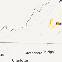
Virginia
| Local Time | Report Details |
|---|---|
| 4:15 PM EDT | Tree down on rt 220 near muddy run rd in bath county VA, 57 miles S of Elkins, WV |
| 4:20 PM EDT | Tree down on rt 220 near the highland county lin in bath county VA, 49 miles S of Elkins, WV |
| 4:40 PM EDT | 2 trees down on long island rd in campbell county VA, 48.2 miles E of Roanoke, VA |
| 4:40 PM EDT | Tree down on gladys road in campbell county VA, 47.8 miles E of Roanoke, VA |
| 5:30 PM EDT | Multiple trees down in the pattie rd and howardsville turnpike are in buckingham county VA, 52.5 miles W of Richmond, VA |
| 5:51 PM EDT | Half Dollar sized hail reported near Scottsville, VA, 49.1 miles WNW of Richmond, VA |
| 5:54 PM EDT | Trees and powerlines down near kidds dairy r in fluvanna county VA, 47.1 miles WNW of Richmond, VA |
| 5:55 PM EDT | Tree down off rt 40 in pittsylvania county VA, 39.4 miles SE of Roanoke, VA |
| 5:58 PM EDT | Several trees down along surgar fork road just north of cumberland. the road was patially close in cumberland county VA, 33 miles W of Richmond, VA |
| 6:00 PM EDT | Multiple trees down around gretna including business rt 2 in pittsylvania county VA, 39 miles SE of Roanoke, VA |
| 6:10 PM EDT | Tree down on rt 57 in pittsylvania county VA, 43.9 miles SE of Roanoke, VA |
| 6:10 PM EDT | Tree down on rt 57 in pittsylvania county VA, 45.1 miles SE of Roanoke, VA |
| 6:10 PM EDT | Trees down along catersville road cleared by fire departmen in cumberland county VA, 29.2 miles WNW of Richmond, VA |
| 6:23 PM EDT | Large tree down at clayton hall rd and route in loudoun county VA, 66.7 miles W of Baltimore, MD |
| 6:25 PM EDT | Numerous trees and power lines down south of gordonsvill in louisa county VA, 51.8 miles NW of Richmond, VA |
| 6:26 PM EDT | Trees and powerlines down in louisa county VA, 50 miles NW of Richmond, VA |
| 6:27 PM EDT | Multiple trees down in nathali in halifax county VA, 59.6 miles ESE of Roanoke, VA |
| 6:27 PM EDT | Trees down near moseley ferry roa in halifax county VA, 72.2 miles N of Raleigh, NC |
| 6:27 PM EDT | Trees down on black walnut roa in halifax county VA, 72.9 miles ESE of Roanoke, VA |
| 6:31 PM EDT | Numerous trees down. tree on a car in powhatan county VA, 24.8 miles WNW of Richmond, VA |
| 6:40 PM EDT | Trees down along rock castle roa in goochland county VA, 21.3 miles NW of Richmond, VA |
| 6:47 PM EDT | Nunerous trees down along sandy hook roa in goochland county VA, 20.4 miles NW of Richmond, VA |
| 6:47 PM EDT | Quarter sized hail reported near Goochland, VA, 20.4 miles NW of Richmond, VA, quarter size and larger hail reported. |
| 6:54 PM EDT | Trees and powerlines down 2400 block of sandy hook rd in goochland county VA, 22.1 miles NW of Richmond, VA |
| 6:54 PM EDT | Trees and powerlines down near lock castle rd in goochland county VA, 21.1 miles NW of Richmond, VA |
| 6:55 PM EDT | Multiple trees down throughout the tow in charlotte county VA, 62.3 miles WSW of Richmond, VA |
| 7:03 PM EDT | Trees down around chase city in mecklenburg county VA, 65.9 miles SW of Richmond, VA |
| 7:04 PM EDT | Numerous trees down around hampden sydney in prince edward county VA, 48.1 miles WSW of Richmond, VA |
| 7:05 PM EDT | Numerous trees down near prospect in prince edward county VA, 51.9 miles WSW of Richmond, VA |
| 7:14 PM EDT | Tree down at routes 56 and 602 in buckingham county VA, 52.4 miles W of Richmond, VA |
| 7:17 PM EDT | Multiple trees down in the glenmore are in buckingham county VA, 53.8 miles WNW of Richmond, VA |
| 7:18 PM EDT | Trees down alomg poorhouse road near victori in lunenburg county VA, 46.9 miles SW of Richmond, VA |
| 7:18 PM EDT | Tree down on hwy 15 near chestnut hill ln in loudoun county VA, 49.4 miles W of Baltimore, MD |
| 7:20 PM EDT | Tree down in sprouses corner in buckingham county VA, 46.6 miles W of Richmond, VA |
| 7:25 PM EDT | Numerous trees down north of kenbridge in lunenburg county VA, 44.2 miles SW of Richmond, VA |
| 7:26 PM EDT | Numerous trees and power lines down across much of count in cumberland county VA, 32.3 miles W of Richmond, VA |
| 7:28 PM EDT | A tree was reported down on sudley road at catharpin roa in prince william county VA, 60.5 miles WSW of Baltimore, MD |
| 7:28 PM EDT | A tree was reported down on sudley road and misty acres lan in prince william county VA, 61 miles WSW of Baltimore, MD |
| 7:30 PM EDT | A tree was reported down on sudley road near pageland lan in prince william county VA, 59.9 miles WSW of Baltimore, MD |
| 7:30 PM EDT | Trees and powerlines down across central and eastern nottoway count in nottoway county VA, 34.9 miles SW of Richmond, VA |
| 7:33 PM EDT | Tree down on lenah rd near aldie in loudoun county VA, 57.7 miles WSW of Baltimore, MD |
| 7:33 PM EDT | Tree down at hwy 15 and braddock rd in loudoun county VA, 52.7 miles WSW of Baltimore, MD |
| 7:35 PM EDT | A tree was reported down in the 8500 block of spruce stree in prince william county VA, 57.7 miles SW of Baltimore, MD |
| 7:40 PM EDT | Trees and power lines dow in caroline county VA, 34.8 miles N of Richmond, VA |
| 7:49 PM EDT | Trees down on route 1 near ladysmit in caroline county VA, 36.3 miles NNE of Richmond, VA |
| 7:49 PM EDT | Numerous trees dow in goochland county VA, 25.7 miles NW of Richmond, VA |
| 7:50 PM EDT | Numerous trees down along the powhatan and goochland county line. more trees and power lines were down across portions of the count in powhatan county VA, 11.9 miles NW of Richmond, VA |
| 7:53 PM EDT | Numerous trees down near clarksvill in mecklenburg county VA, 57.7 miles N of Raleigh, NC |
| 7:53 PM EDT | Numerous trees and power lines down countywide. locations from goochland west and north had the most number of trees dow in goochland county VA, 17.9 miles NW of Richmond, VA |
| 8:00 PM EDT | Trees and power lines down in the fine creeks mills are in powhatan county VA, 11.4 miles NW of Richmond, VA |
| 8:12 PM EDT | A large tree was reported down on route 1 near jason lan in stafford county VA, 66 miles NNE of Richmond, VA |
| 8:19 PM EDT | Trees down around stoney poin in city of richmond county VA, 5.5 miles NE of Richmond, VA |
| 8:22 PM EDT | Trees down across 301n in hanover county VA, 26.7 miles NNE of Richmond, VA |
| 8:22 PM EDT | Trees and power lines reported down in richmond by fire dep in city of richmond county VA, 11 miles ENE of Richmond, VA |
| 8:24 PM EDT | Numerous trees down around port royal in caroline county VA, 52.4 miles NNE of Richmond, VA |
| 8:26 PM EDT | Storm damage reported in prince william county VA, 65.5 miles SW of Baltimore, MD |
| 8:30 PM EDT | Trees down across 301n in caroline county VA, 41.1 miles NNE of Richmond, VA |
| 8:30 PM EDT | Numerous trees down around south hil in mecklenburg county VA, 59.5 miles SSW of Richmond, VA |
| 8:31 PM EDT | Numerous trees and power lines down around victoria reported with the second thunderstorm in lunenburg county VA, 47.3 miles SW of Richmond, VA |
| 8:31 PM EDT | A tree was reported down on caledon road near indiantown roa in king george county VA, 62.1 miles NNE of Richmond, VA |
| 8:31 PM EDT | Trees down along plank roa in lunenburg county VA, 50 miles SW of Richmond, VA |
| 8:45 PM EDT | Large tree down on reunion driv in hanover county VA, 20.7 miles ENE of Richmond, VA |
| 8:51 PM EDT | Trees and powe lines down around oak grove in westmoreland county VA, 58.7 miles NE of Richmond, VA |
| 8:51 PM EDT | Trees downed along highway 36 in nottoway county VA, 35 miles SW of Richmond, VA |
| 8:55 PM EDT | Numerous trees down in westmoreland county VA, 54.9 miles NE of Richmond, VA |
| 9:05 PM EDT | Trees and power lines dow in westmoreland county VA, 69 miles ENE of Richmond, VA |
| 9:09 PM EDT | Tree downed along namozine roa in amelia county VA, 20.3 miles SSW of Richmond, VA |
| 9:10 PM EDT | Numerous trees down across the area. highway 17 blocked along with several other road in essex county VA, 51.5 miles NE of Richmond, VA |
| 9:30 PM EDT | Trees down along the boulevard. the road was closed. trees on several ca in city of richmond county VA, 11 miles ENE of Richmond, VA |
| 9:50 PM EDT | Numerosu trees and power lines down across much of new kent county in new kent county VA, 29.2 miles E of Richmond, VA |
| 9:55 PM EDT | Numerous trees and power lines down across the northern end of the count in king william county VA, 29.7 miles NE of Richmond, VA |
| 9:55 PM EDT | Trees down along highway 36 in king william county VA, 31 miles ENE of Richmond, VA |
| 10:05 PM EDT | Tree and power line down on brink road in greensville county VA, 57.7 miles S of Richmond, VA |
| 10:07 PM EDT | Numerous trees and power lines in the lee street at ergra park area in city of emporia county VA, 56.4 miles S of Richmond, VA |
| 10:25 PM EDT | Trees and power lines down near newland in richmond county VA, 57 miles NE of Richmond, VA |
| 10:25 PM EDT | Trees down from naylor beach to warsaw in richmond county VA, 58.1 miles ENE of Richmond, VA |
| 10:48 PM EDT | Large limb down in parking lot of nws offic in surry county VA, 43.8 miles ESE of Richmond, VA |
| 11:10 PM EDT | Trees and power lines down in the rushmere and burwell bay area. a trampoline was blocking a portion of route 10 after being blown into the roa in isle of wight county VA, 40.6 miles NW of Virginia Beach, VA |
| 11:25 PM EDT | Tree down taking down power lines and damaging a fence in city of newport ne county VA, 38.9 miles NW of Virginia Beach, VA |
| 11:28 PM EDT | Some trees down near gloucester in gloucester county VA, 52.1 miles NNW of Virginia Beach, VA |
| 11:29 PM EDT | Trees and power lines down on robinson drive and beechmont drive in city of newport ne county VA, 33.5 miles NW of Virginia Beach, VA |
| 11:37 PM EDT | Trees down around poquoson in city of poquoson county VA, 31.4 miles NW of Virginia Beach, VA |
| 12:24 AM EDT | Numerous trees down blocking road in accomack county VA, 59.3 miles SW of Ocean City, MD |
| 12:24 AM EDT | Tree down in painter in accomack county VA, 59.6 miles NNE of Virginia Beach, VA |
| 12:25 AM EDT | Tree down in city of norfolk county VA, 15.5 miles WNW of Virginia Beach, VA |
| 12:35 AM EDT | Tree downed on helmick av in city of norfolk county VA, 18.5 miles NW of Virginia Beach, VA |
Pennsylvania
| Local Time | Report Details |
|---|---|
| 4:16 PM EDT | Trees down along gettamy rd in dunbar... pa in fayette county PA, 43 miles SSE of Pittsburgh, PA |
| 4:32 PM EDT | Wires down at the intersection of chaintown road and west pittsburgh s in westmoreland county PA, 30.2 miles SE of Pittsburgh, PA |
| 4:40 PM EDT | Numerous trees down in south union township in fayette county PA, 41.2 miles SSE of Pittsburgh, PA |
| 4:42 PM EDT | Tree down on county line road in somerset county PA, 46.8 miles SE of Pittsburgh, PA |
| 4:47 PM EDT | Wires down along murray ave in unity twp in westmoreland county PA, 33.9 miles ESE of Pittsburgh, PA |
| 4:57 PM EDT | Trees down along mt thor road in westmoreland county PA, 25.7 miles ESE of Pittsburgh, PA |
| 5:27 PM EDT | Trees down near westmont in cambria county PA, 55.9 miles E of Pittsburgh, PA |
| 5:32 PM EDT | Numerous trees down across southern cambria county in cambria county PA, 57.3 miles E of Pittsburgh, PA |
| 5:38 PM EDT | Trees down in indiana county PA, 54.8 miles ENE of Pittsburgh, PA |
| 5:38 PM EDT | Trees down in indiana county PA, 41.1 miles ENE of Pittsburgh, PA |
| 5:40 PM EDT | Trees down along fulmer road in conemaugh twp in cambria county PA, 60.6 miles E of Pittsburgh, PA |
| 5:45 PM EDT | Trees down in indiana county PA, 40.3 miles ENE of Pittsburgh, PA |
| 5:48 PM EDT | Trees down in indiana county PA, 55.3 miles ENE of Pittsburgh, PA |
| 8:11 PM EDT | Trees down in menallen twp in adams county PA, 58.6 miles NW of Baltimore, MD |
| 8:45 PM EDT | Trees down near mount holly spring in cumberland county PA, 59.3 miles SE of State College, PA |
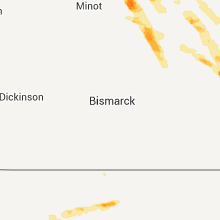
North Dakota
| Local Time | Report Details |
|---|---|
| 3:21 PM CDT | Half Dollar sized hail reported near Harvey, ND, 52.2 miles WSW of Devils Lake, ND, still hailing as of 325 pm cdt with heavy rain |
| 4:35 PM CDT | Quarter sized hail reported near New Rockford, ND, 32.6 miles SSW of Devils Lake, ND, twitter post |
| 5:01 PM CDT | Quarter sized hail reported near Grace City, ND, 39.6 miles S of Devils Lake, ND, quarter size hail lasted for 4 minutes. strong winds knocked out power and 0.27 inches of rain. |
| 5:20 PM CDT | Ping Pong Ball sized hail reported near Devils Lake, ND, 6.6 miles W of Devils Lake, ND, from twitter |
| 5:59 PM CDT | Golf Ball sized hail reported near Hannaford, ND, 66.6 miles SSE of Devils Lake, ND |
| 6:03 PM CDT | Half Dollar sized hail reported near Oriska, ND, 47.8 miles W of Fargo, ND |
| 6:04 PM CDT | Quarter sized hail reported near Hannaford, ND, 64.2 miles SSE of Devils Lake, ND |
| 6:13 PM CDT | Golf Ball sized hail reported near Dazey, ND, 69.5 miles WNW of Fargo, ND |
| 6:43 PM CDT | Quarter sized hail reported near Sharon, ND, 54.8 miles SE of Devils Lake, ND |
| 7:22 PM CDT | 50 foot tall tree blown down in richland county ND, 33.7 miles SSW of Fargo, ND |
| 7:22 PM CDT | Quarter sized hail reported near Wyndmere, ND, 33.7 miles SSW of Fargo, ND |
| 7:55 PM CDT | Ping Pong Ball sized hail reported near Wahpeton, ND, 47.4 miles S of Fargo, ND |
| 8:08 PM CDT | Quarter sized hail reported near Fairmount, ND, 59.1 miles S of Fargo, ND |
| 8:34 PM CDT | Storm damage reported in mchenry county ND, 41.6 miles ENE of Minot, ND |
| 8:34 PM CDT | Golf Ball sized hail reported near Towner, ND, 41.6 miles ENE of Minot, ND, mainly half dollar sized hail with some golf ball sized. |
| 8:40 PM CDT | Golf Ball sized hail reported near Towner, ND, 41.6 miles ENE of Minot, ND, hail lasted 10 minutes. |
| 9:44 PM CDT | Quarter sized hail reported near Harvey, ND, 53.7 miles WSW of Devils Lake, ND, quarter size hail started at 936 pm and lasted to 0940 pm cdt. |
| 10:00 PM CDT | Golf Ball sized hail reported near Harvey, ND, 55.5 miles WSW of Devils Lake, ND, 50 to 60 mph winds also reported |
| 10:00 PM CDT | Hen Egg sized hail reported near Harvey, ND, 55.5 miles WSW of Devils Lake, ND, at khnd radio |
| 10:40 PM CDT | Quarter sized hail reported near Bowdon, ND, 59.5 miles SW of Devils Lake, ND |
South Carolina
| Local Time | Report Details |
|---|---|
| 5:30 PM EDT | Spotter reported multiple limbs down on emerson st in greenwood county SC, 42.3 miles SSE of Greenville, SC |
| 5:41 PM EDT | Tree down on roadway in laurens county SC, 44.6 miles SE of Greenville, SC |
| 6:12 PM EDT | Sc highway patrol reports trees down on us hwy 178 near sardis roa in saluda county SC, 38.7 miles NNE of Augusta, GA |
| 6:17 PM EDT | Saluda co. dispatch reported trees down on spann roa in saluda county SC, 41.9 miles NNE of Augusta, GA |
| 6:22 PM EDT | Saluda co. dispatch reported trees down on west creek roa in saluda county SC, 41.4 miles NE of Augusta, GA |
| 6:31 PM EDT | Highway patrol reported trees down at dog leg rd. and tom addy rd. in leesvill in lexington county SC, 43.2 miles NE of Augusta, GA |
Illinois
| Local Time | Report Details |
|---|---|
| 4:35 PM CDT | A tree blown down in the city of freepor in stephenson county IL, 55.4 miles SSW of Madison, WI |
| 7:45 PM CDT | Trees down across roads. power out. time estimate in hancock county IL, 32.8 miles ENE of Kahoka, MO |
| 8:01 PM CDT | Power lines down...time estimated from rada in henderson county IL, 51.1 miles ENE of Kahoka, MO |
| 8:12 PM CDT | Trees down across northern part of county...including good hope and macomb. time estimated from rada in mcdonough county IL, 56.1 miles E of Kahoka, MO |
| 8:36 PM CDT | Several trees and power lines down in town in knox county IL, 45.2 miles WNW of Peoria, IL |
| 8:36 PM CDT | Trees down in knox county IL, 51.4 miles NW of Peoria, IL |
| 8:45 PM CDT | Trees down in knox county IL, 42.6 miles NW of Peoria, IL |
| 8:45 PM CDT | Trees down in town in schuyler county IL, 51.8 miles ESE of Kahoka, MO |
| 8:50 PM CDT | Tree and power pole down in knox county IL, 42.1 miles NW of Peoria, IL |
| 8:50 PM CDT | Tree down in knox county IL, 40.6 miles NW of Peoria, IL |
| 9:00 PM CDT | 11 inch diameter tree snapped off at 8th and jefferson street in adams county IL, 38.1 miles SSE of Kahoka, MO |
| 9:05 PM CDT | Power line down in stark county IL, 29.3 miles NNW of Peoria, IL |
| 9:15 PM CDT | Tree down in mason county IL, 36.8 miles SW of Peoria, IL |
| 9:25 PM CDT | 3 to 4 inch diameter tree limbs down in peoria county IL, 3.5 miles NNW of Peoria, IL |
| 9:25 PM CDT | Tree limbs down on power lines at rt. 40 and 150...and at rt. 40 and glenn av in peoria county IL, 3.5 miles NNW of Peoria, IL |
| 9:39 PM CDT | One foot diameter tree down on rt. 26. also power lines dow in marshall county IL, 31.2 miles NNE of Peoria, IL |
| 9:49 PM CDT | Tree down on rt. 89 in marshall county IL, 31.3 miles NE of Peoria, IL |
| 9:50 PM CDT | Trees down in morgan county IL, 74 miles SSW of Peoria, IL |
| 9:55 PM CDT | Trees down at hearts prairie rd and rt. 104 in morgan county IL, 68.9 miles N of Saint Louis, MO |
| 9:58 PM CDT | Near route 18. one tree and power lines dow in la salle county IL, 41.5 miles NE of Peoria, IL |
| 10:05 PM CDT | At fourth street and pond. one tree snapped onto power lines. via social medi in la salle county IL, 41.5 miles NE of Peoria, IL |
| 10:05 PM CDT | Tree limb down on old 36 in sangamon county IL, 58.2 miles S of Peoria, IL |
| 10:09 PM CDT | Tree down blocking rt. 54. from logan co. e in sangamon county IL, 54.8 miles S of Peoria, IL |
| 10:14 PM CDT | Tree down on mobile home in sangamon county IL, 59.1 miles WNW of Mattoon, IL |
| 10:35 PM CDT | Small tree limbs down in christian county IL, 58.1 miles W of Mattoon, IL |
| 10:45 PM CDT | Tree down on grand ave. from wand-t in macon county IL, 39 miles NW of Mattoon, IL |
| 11:03 PM CDT | Tree limbs down northwest of buckley near i-57. facebook report. time estimate in iroquois county IL, 79.2 miles NNE of Mattoon, IL |
| 11:30 PM CDT | Trees down in vermilion county IL, 77.8 miles NNE of Mattoon, IL |
| 11:30 PM CDT | Storm damage reported in vermilion county IL, 77.8 miles NNE of Mattoon, IL |
| 11:47 PM CDT | 4 to 8 inch diameter tree limbs down in vermilion county IL, 78.4 miles NNE of Mattoon, IL |
| 11:47 PM CDT | Storm damage reported in vermilion county IL, 78.4 miles NNE of Mattoon, IL |
| 12:15 AM CDT | Storm damage reported in clay county IL, 59.8 miles SSW of Mattoon, IL |
Florida
| Local Time | Report Details |
|---|---|
| 5:55 PM EDT | Quarter sized hail reported near Saint Cloud, FL, 26.5 miles SSE of Orlando, FL, harmony sunoco gas station attendant relayed report from public of quarter sized hail while driving along us 192. location estimated. |
| 6:15 PM EDT | Quarter sized hail reported near Eustis, FL, 26.6 miles NW of Orlando, FL, several reports of dime to quarter sized hail relayed via social media across eustis and mount dora. |
South Dakota
| Local Time | Report Details |
|---|---|
| 4:26 PM MDT | Lots of pea size hail that covered the ground in ziebach county SD, 65.2 miles WNW of Pierre, SD |
| 4:53 PM MDT | Ping Pong Ball sized hail reported near Eagle Butte, SD, 49.1 miles WNW of Pierre, SD |
| 5:13 PM MDT | Quarter sized hail reported near Hayes, SD, 37.4 miles WNW of Pierre, SD |
| 5:55 PM MDT | Golf Ball sized hail reported near Faith, SD, 79.3 miles NE of Rapid City, SD |
| 5:55 PM MDT | Storm damage reported in meade county SD, 79.3 miles NE of Rapid City, SD |
| 6:06 PM MDT | Quarter sized hail reported near Wall, SD, 49.1 miles E of Rapid City, SD |
| 6:11 PM MDT | Half Dollar sized hail reported near Rapid City, SD, 15 miles W of Rapid City, SD |
| 6:20 PM MDT | Quarter sized hail reported near Quinn, SD, 62.2 miles E of Rapid City, SD |
| 6:29 PM MDT | Golf Ball sized hail reported near Hot Springs, SD, 47.9 miles SSW of Rapid City, SD |
| 6:34 PM MDT | Storm damage reported in ziebach county SD, 73.1 miles NW of Pierre, SD |
| 6:44 PM MDT | Quarter sized hail reported near Faith, SD, 87.9 miles NE of Rapid City, SD |
| 6:45 PM MDT | Tree blown over us hwy 85...time estimated from radar in lawrence county SD, 35.2 miles WNW of Rapid City, SD |
| 6:58 PM MDT | Tennis Ball sized hail reported near Hot Springs, SD, 53.5 miles S of Rapid City, SD |
| 7:23 PM MDT | Quarter sized hail reported near Sturgis, SD, 22.4 miles NNW of Rapid City, SD, quarter size hail covered the ground...lasted 5 min |
| 7:45 PM MDT | Half Dollar sized hail reported near Pine Ridge, SD, 80.6 miles SSE of Rapid City, SD, 50mph wind gust |
| 7:56 PM MDT | Quarter sized hail reported near Dupree, SD, 90.6 miles NW of Pierre, SD |
| 11:45 PM MDT | Golf Ball sized hail reported near Hill City, SD, 28.1 miles WSW of Rapid City, SD, hail lasted for 10 minutes with a few golf ball sized hail stones. |
| 12:15 AM MDT | Golf Ball sized hail reported near Porcupine, SD, 74.1 miles SE of Rapid City, SD |
| 12:25 AM MDT | Quarter sized hail reported near Keystone, SD, 16.3 miles SW of Rapid City, SD |
| 12:47 AM MDT | Quarter sized hail reported near Hermosa, SD, 22.9 miles S of Rapid City, SD |
| 1:08 AM MDT | Quarter sized hail reported near Kyle, SD, 69.1 miles SE of Rapid City, SD |
Wyoming
| Local Time | Report Details |
|---|---|
| 5:42 PM MDT | Golf Ball sized hail reported near Newcastle, WY, 59.1 miles WSW of Rapid City, SD |
| 5:45 PM MDT | Tennis Ball sized hail reported near Newcastle, WY, 57.9 miles WSW of Rapid City, SD |
| 5:55 PM MDT | Quarter sized hail reported near Newcastle, WY, 52 miles WSW of Rapid City, SD |
Missouri
| Local Time | Report Details |
|---|---|
| 7:52 PM CDT | 10 inch tree limb down over highway 136...power out in town in putnam county MO, 67.6 miles W of Kahoka, MO |
| 7:55 PM CDT | Widespread tree damage across northern portions of county...trees over roads and a chicken coop. time estimated from rada in scotland county MO, 24.4 miles WNW of Kahoka, MO |
| 7:56 PM CDT | Storm damage reported in putnam county MO, 62.9 miles W of Kahoka, MO |
| 8:05 PM CDT | Many trees uprooted largest of which was 3 foot in diamete in putnam county MO, 67.6 miles W of Kahoka, MO |
| 8:05 PM CDT | Half Dollar sized hail reported near Unionville, MO, 67.6 miles W of Kahoka, MO |
| 8:10 PM CDT | Storm damage reported in putnam county MO, 71.2 miles W of Kahoka, MO |
| 8:28 PM CDT | 2 inch branches down in putnam county MO, 54.9 miles W of Kahoka, MO |
| 8:30 PM CDT | Storm damage reported in sullivan county MO, 65.8 miles W of Kahoka, MO |
| 9:12 PM CDT | Quarter sized hail reported near Green Castle, MO, 58 miles W of Kahoka, MO |
| 9:12 PM CDT | Branches down in adair county MO, 58 miles W of Kahoka, MO |
| 1:00 AM CDT | Several large tree limbs blown dow in marion county MO, 44.1 miles SSE of Kahoka, MO |
Nebraska
| Local Time | Report Details |
|---|---|
| 7:31 PM MDT | Public estimated wind gust of 70 mph for a couple of minute in sheridan county NE, 84.1 miles SSE of Rapid City, SD |
| 7:31 PM MDT | Golf Ball sized hail reported near Rushville, NE, 84.1 miles SSE of Rapid City, SD |
| 7:52 PM MDT | Public estimated wind gust of 70 mph for a couple of minute in sheridan county NE, 84.1 miles SSE of Rapid City, SD |
| 7:52 PM MDT | Golf Ball sized hail reported near Rushville, NE, 84.1 miles SSE of Rapid City, SD |
| 7:55 PM MDT | Golf Ball sized hail reported near Rushville, NE, 87.2 miles NE of Scottsbluff, NE |
| 8:00 PM MDT | Golf Ball sized hail reported near Gordon, NE, 86.9 miles NE of Scottsbluff, NE, delayed report...damage to siding and roof of house. |
| 8:01 PM MDT | Quarter sized hail reported near Rushville, NE, 89.6 miles NE of Scottsbluff, NE |
| 8:03 PM MDT | Quarter sized hail reported near Gordon, NE, 83.7 miles W of Valentine, NE, very little wind with the hail. |
| 8:08 PM MDT | Quarter sized hail reported near Gordon, NE, 88.1 miles W of Valentine, NE |
| 8:12 PM MDT | Trained spotter reported 40-50 mph winds. several trees were blown ove in sheridan county NE, 87.1 miles NE of Scottsbluff, NE |
| 8:12 PM MDT | Quarter sized hail reported near Gordon, NE, 89.9 miles NE of Scottsbluff, NE |
| 8:12 PM MDT | Ping Pong Ball sized hail reported near Rushville, NE, 87.1 miles NE of Scottsbluff, NE |
| 8:26 PM MDT | Storm damage reported in sheridan county NE, 89 miles NE of Scottsbluff, NE |
| 8:26 PM MDT | Quarter sized hail reported near Gordon, NE, 89.9 miles NE of Scottsbluff, NE |
| 8:26 PM MDT | Golf Ball sized hail reported near Gordon, NE, 89 miles NE of Scottsbluff, NE, winds on the north side of the residents were all broken out. |
| 8:35 PM MDT | Golf Ball sized hail reported near Gordon, NE, 84.1 miles W of Valentine, NE, relayed via storm chaser |
| 8:35 PM MDT | Golf Ball sized hail reported near Gordon, NE, 87.9 miles NE of Scottsbluff, NE |
| 8:54 PM MDT | Quarter sized hail reported near Gordon, NE, 86.2 miles WSW of Valentine, NE |
| 9:15 PM MDT | Quarter sized hail reported near Whitman, NE, 68.2 miles SW of Valentine, NE |
| 9:45 PM MDT | Quarter sized hail reported near Mullen, NE, 62.7 miles SSW of Valentine, NE, a brief period of quarter size hail...then the hail stones were mostly pea size. |
| 5:35 AM MDT | Quarter sized hail reported near Mullen, NE, 44.7 miles NNW of North Platte, NE, also e40 mph winds |
Delaware
| Local Time | Report Details |
|---|---|
| 12:51 AM EDT | Storm damage reported in sussex county DE, 15 miles NNW of Ocean City, MD |
Indiana
| Local Time | Report Details |
|---|---|
| 1:10 AM EDT | Tree down on house. time estimate in tippecanoe county IN, 58.5 miles NW of Indianapolis, IN |
| 1:15 AM EDT | Measured on the south side of lafayette in tippecanoe county IN, 58.5 miles NW of Indianapolis, IN |
| 1:27 AM EDT | Tree down on power line. time estimate in tippecanoe county IN, 46.7 miles NW of Indianapolis, IN |
| 2:15 AM EDT | Measured by asos in boone county IN, 14.2 miles NNW of Indianapolis, IN |
Connect with Interactive Hail Maps