

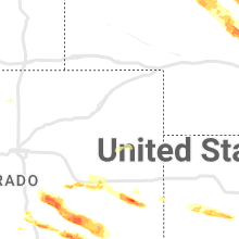
Hail Map for Monday, June 6, 2022

Number of Impacted Households on 6/6/2022
0
Impacted by 1" or Larger Hail
0
Impacted by 1.75" or Larger Hail
0
Impacted by 2.5" or Larger Hail
Square Miles of Populated Area Impacted on 6/6/2022
0
Impacted by 1" or Larger Hail
0
Impacted by 1.75" or Larger Hail
0
Impacted by 2.5" or Larger Hail


Cities Most Affected by Hail Storms of 6/6/2022
| Hail Size | Demographics of Zip Codes Affected | ||||||
|---|---|---|---|---|---|---|---|
| City | Count | Average | Largest | Pop Density | House Value | Income | Age |
| Burdett, KS | 2 | 4.00 | 4.00 | 2 | $40k | $38.2k | 47.6 |
| Spearville, KS | 2 | 2.25 | 2.75 | 3 | $66k | $40.3k | 41.7 |
| Albion, NE | 2 | 2.13 | 2.50 | 9 | $65k | $32.9k | 45.5 |
| Lamar, CO | 2 | 1.75 | 1.75 | 13 | $72k | $30.3k | 35.8 |
| Sugar City, CO | 2 | 1.75 | 1.75 | 0 | $52k | $30.1k | 52.0 |
| Mullen, NE | 2 | 1.75 | 1.75 | 0 | $41k | $28.7k | 49.6 |
| Petersburg, NE | 2 | 1.75 | 1.75 | 4 | $38k | $29.9k | 47.9 |
| Miller, NE | 2 | 1.75 | 1.75 | 3 | $71k | $34.7k | 43.0 |
| Oelrichs, SD | 1 | 2.00 | 2.00 | 0 | $25k | $29.5k | 50.6 |
| Saint Edward, NE | 1 | 2.00 | 2.00 | 5 | $39k | $29.9k | 45.2 |
| Merriman, NE | 1 | 1.75 | 1.75 | 0 | $30k | $26.6k | 47.3 |
| Gordon, NE | 1 | 1.75 | 1.75 | 2 | $46k | $28.0k | 45.1 |
| Colorado Springs, CO | 1 | 1.75 | 1.75 | 802 | $0k | $0.0k | 21.8 |
| Oglala, SD | 1 | 1.75 | 1.75 | 0 | $13k | $17.4k | 22.1 |
Hail and Wind Damage Spotted on 6/6/2022
Filter by Report Type:Hail ReportsWind Reports
States Impacted
Iowa, Ohio, Kentucky, Florida, Alabama, Georgia, Indiana, Nebraska, Tennessee, South Dakota, Illinois, Colorado, Kansas, Texas, OklahomaIowa
| Local Time | Report Details |
|---|---|
| 12:05 PM CDT | Three outbuildings damaged... one destroyed. time estimated by rada in guthrie county IA, 43.2 miles W of Des Moines, IA |
| 12:19 PM CDT | Large tree down. time estimated by rada in guthrie county IA, 37.5 miles W of Des Moines, IA |
Ohio
| Local Time | Report Details |
|---|---|
| 1:26 PM EDT | Large live tree down near i-73 between i-71 and dutch cree in clinton county OH, 41 miles NE of Cincinnati, OH |
| 1:27 PM EDT | Large tree reported down on 73 and williams road. time estimated from rada in clinton county OH, 41 miles NE of Cincinnati, OH |
| 1:27 PM EDT | Storm damage reported in clinton county OH, 42.6 miles ENE of Cincinnati, OH |
| 1:49 PM EDT | Tree down on power lines on mcdowell street. time estimated from rada in greene county OH, 49.6 miles NE of Cincinnati, OH |
| 2:15 PM EDT | Large tree down blocking residential road in washington court house... oh. time estimated from rada in fayette county OH, 36.9 miles SW of Columbus, OH |
| 3:10 PM EDT | Large tree down near intersection of lincoln highway and thayer road. time estimated from rada in allen county OH, 59.4 miles ESE of Fort Wayne, IN |
| 3:45 PM EDT | Tree down on wires on trumbull court. time estimated from rada in hamilton county OH, 10.2 miles WNW of Cincinnati, OH |
| 3:52 PM EDT | Several thick branches down at residential address. time estimated from radar in hamilton county OH, 5.8 miles WSW of Cincinnati, OH |
| 4:10 PM EDT | Witnessed sign blown off its pol in butler county OH, 20.4 miles NNW of Cincinnati, OH |
| 4:31 PM EDT | Trees down on butterworth road. time estimated from rada in warren county OH, 19.1 miles NE of Cincinnati, OH |
| 5:21 PM EDT | Trees down near markley rd and s shiloh rd. time estimated from rada in miami county OH, 60.6 miles N of Cincinnati, OH |
Kentucky
| Local Time | Report Details |
|---|---|
| 2:13 PM EDT | Scattered reports of trees down between goshen and crestwood...power lines down between crestwood and la grange...possible damage to a barn and trees on a goat farm on in oldham county KY, 28 miles NNE of Louisville, KY |
| 2:57 PM EDT | Power poles down 1200 block of highland. time estimated from rada in carroll county KY, 46.4 miles SW of Cincinnati, OH |
| 3:36 PM EDT | Trees down on old new liberty road. time estimated from rada in owen county KY, 41.3 miles SSW of Cincinnati, OH |
| 3:56 PM EDT | Trees down on o banion lan in owen county KY, 42.5 miles SSW of Cincinnati, OH |
| 7:47 PM EDT | Report of power lines down just nw of lawrencebur in anderson county KY, 45.2 miles E of Louisville, KY |
Florida
| Local Time | Report Details |
|---|---|
| 2:30 PM EDT | Quarter sized hail reported near Deltona, FL, 30.1 miles NNE of Orlando, FL, public report via twitter of dime to quarter size hail near lake helen osteen rd and haulover blvd in deltona. |
| 3:00 PM EDT | Caller reported a tree down in madison county along highway 53... a mile south of midway church rd. caller recorded a peak surface wind of 29 mp in madison county FL, 56.6 miles E of Tallahassee, FL |
| 3:03 PM EDT | Palm coast tree down into transformer wires reported by fcs in flagler county FL, 58.9 miles SSE of Jacksonville, FL |
| 3:04 PM EDT | Quarter sized hail reported near Palm Coast, FL, 58.9 miles SSE of Jacksonville, FL |
| 3:10 PM EDT | One hour delayed report. em reports of multiple screens blown out of lanias in nw palm coas in flagler county FL, 56.6 miles SSE of Jacksonville, FL |
| 3:20 PM EDT | Half Dollar sized hail reported near Palm Coast, FL, 60.5 miles SSE of Jacksonville, FL, spotter reports quarter to half dollar sized hail in palm coast... location approximated. |
| 3:35 PM EDT | Delayed report. medium size tree branch down and blown into neighbors yard... photo on twitter. time estimated from rada in flagler county FL, 59.8 miles SSE of Jacksonville, FL |
| 3:49 PM EDT | Quarter sized hail reported near Oviedo, FL, 13.7 miles NE of Orlando, FL, trained sportter report via twitter of dime to quarter size hail near kelly green st and n pine ave in ovideo. time estimated via radar. |
| 3:50 PM EDT | Half Dollar sized hail reported near Winter Springs, FL, 10.1 miles NE of Orlando, FL, second public report via twitter with picture of half dollar size hail near red bug lake rd and tuskawilla rd in winter springs |
| 3:55 PM EDT | Half Dollar sized hail reported near Winter Springs, FL, 10.1 miles NE of Orlando, FL, public report via twitter of half dollar size hail with picture near red bug lake rd and tuskawilla rd in winter springs. |
| 4:05 PM EDT | Ham radio relayed report from seminole county em of downed powerlines on cr-419 in chuluota. time estimated from rada in seminole county FL, 16.6 miles ENE of Orlando, FL |
| 4:24 PM EDT | Weatherflow xpar at parrish park in titusville measured a peak wind gust of 51kt/59mph from the nn in amz552 county FL, 35.1 miles E of Orlando, FL |
| 5:00 PM EDT | Ussf wind tower 415 measured a peak wind gust of 51kt/59mph from the nn in brevard county FL, 42 miles ENE of Orlando, FL |
| 5:10 PM EDT | Ussf wind tower 412 measured a peak wind gust of 51kt/59mph from the n in brevard county FL, 43.3 miles E of Orlando, FL |
| 5:21 PM EDT | A mesonet at sebastian inlet pier measured a peak wind gust of 53mph/61kt from the n in amz552 county FL, 40.6 miles N of Port Saint Lucie, FL |
| 8:20 PM EDT | Weatheflow tempest mesonet in stuart on e 7th street measured a peak wind gust of 54kt/62mp in martin county FL, 10 miles SE of Port Saint Lucie, FL |
| 8:25 PM EDT | Xjen update: gust to 51kt/59mph from the sout in amz555 county FL, 10.7 miles ESE of Port Saint Lucie, FL |
Alabama
| Local Time | Report Details |
|---|---|
| 1:30 PM CDT | Numerous trees knocked over in the goldridge community. time estimated from rada in cullman county AL, 51.1 miles N of Birmingham, AL |
| 3:15 PM CDT | A large tree was knocked down blocking both lanes of highway 79 at gizzard point road in skyline. time estimated by rada in jackson county AL, 49.3 miles WSW of Chattanooga, TN |
Georgia
| Local Time | Report Details |
|---|---|
| 2:35 PM EDT | A large tree was downed across thomaston stree in lamar county GA, 49.9 miles SSE of Atlanta, GA |
| 2:38 PM EDT | Several trees were downed in barnesville... including at the intersection of hwy 341 and zebulon rd. siding was also removed from a building on grove r in lamar county GA, 49.8 miles SSE of Atlanta, GA |
Indiana
| Local Time | Report Details |
|---|---|
| 2:58 PM EDT | Tree removed from road near 56 and lamb drive. time estimated from rada in switzerland county IN, 46.8 miles SW of Cincinnati, OH |
| 3:27 PM EDT | Large tree downed across sr 229 and huntsville rd. time estimated by rada in ripley county IN, 40.9 miles WNW of Cincinnati, OH |
| 3:32 PM EDT | Tree downed across a portion of interstate 74. time estimated by rada in ripley county IN, 40.9 miles WNW of Cincinnati, OH |
| 3:43 PM EDT | Tree down power pole on 229. time estimated from rada in franklin county IN, 41.6 miles WNW of Cincinnati, OH |
| 3:55 PM EDT | Tree down on wires on west klein. time estimated from rada in franklin county IN, 35.1 miles NW of Cincinnati, OH |
| 4:25 PM EDT | Storm damage reported in wayne county IN, 48.5 miles NNW of Cincinnati, OH |
Nebraska
| Local Time | Report Details |
|---|---|
| 2:28 PM CDT | Quarter sized hail reported near Petersburg, NE, 51.1 miles SE of Oneill, NE, hail just began. quarter size hail so far. |
| 2:29 PM CDT | Golf Ball sized hail reported near Petersburg, NE, 50.5 miles SE of Oneill, NE, significant tree and crop damage from golf ball size hail. hail covering the ground. |
| 2:33 PM CDT | Golf Ball sized hail reported near Petersburg, NE, 51.1 miles SE of Oneill, NE, hail to at least golf ball size shattered a police vehicle windshield and one side window. |
| 2:35 PM CDT | Half Dollar sized hail reported near Petersburg, NE, 51.1 miles SSE of Oneill, NE |
| 2:49 PM CDT | Golf Ball sized hail reported near Albion, NE, 55.7 miles NNE of Grand Island, NE, late report. |
| 2:52 PM CDT | 1.5 inch hail and winds 50 to 60 mp in boone county NE, 55.7 miles NNE of Grand Island, NE |
| 2:52 PM CDT | Ping Pong Ball sized hail reported near Albion, NE, 55.7 miles NNE of Grand Island, NE, hail to 1.5 inches in diameter and 50 to 60 mph wind. |
| 2:52 PM CDT | Tennis Ball sized hail reported near Albion, NE, 55.7 miles NNE of Grand Island, NE, delayed report. |
| 2:54 PM CDT | Ping Pong Ball sized hail reported near Albion, NE, 55.7 miles NNE of Grand Island, NE |
| 3:09 PM CDT | Hen Egg sized hail reported near Saint Edward, NE, 51.4 miles NNE of Grand Island, NE, accompanied by strong wind. |
| 3:13 PM CDT | Overturned center pivo in boone county NE, 50.8 miles NNE of Grand Island, NE |
| 3:18 PM CDT | Ping Pong Ball sized hail reported near Genoa, NE, 51.2 miles NNE of Grand Island, NE, hail not quite golf ball size reported. |
| 2:24 PM MDT | Half Dollar sized hail reported near Merriman, NE, 58.4 miles W of Valentine, NE, report via twitter. |
| 2:24 PM MDT | Half Dollar sized hail reported near Mullen, NE, 59.3 miles NNW of North Platte, NE, report via twitter. |
| 3:30 PM MDT | Golf Ball sized hail reported near Mullen, NE, 45.9 miles SSW of Valentine, NE, golf ball sized hail. shredded trees. |
| 3:34 PM MDT | Quarter sized hail reported near Mullen, NE, 45.6 miles SSW of Valentine, NE, via spotternetwork.org |
| 3:59 PM MDT | Quarter sized hail reported near Gordon, NE, 67.5 miles W of Valentine, NE, via spotternetwork.org |
| 4:00 PM MDT | Golf Ball sized hail reported near Merriman, NE, 65 miles W of Valentine, NE |
| 5:34 PM CDT | Half Dollar sized hail reported near Dunning, NE, 59 miles NE of North Platte, NE, report via twitter |
| 5:20 PM MDT | Quarter sized hail reported near Gordon, NE, 90 miles W of Valentine, NE, via twitter. |
| 6:37 PM CDT | Quarter sized hail reported near Broken Bow, NE, 55.4 miles E of North Platte, NE, via spotternetwork.org |
| 5:40 PM MDT | Quarter sized hail reported near Gordon, NE, 84.5 miles W of Valentine, NE, via spotternetwork.org |
| 5:55 PM MDT | Golf Ball sized hail reported near Gordon, NE, 76.7 miles WSW of Valentine, NE |
| 7:12 PM CDT | Quarter sized hail reported near Eddyville, NE, 60.2 miles E of North Platte, NE |
| 7:43 PM CDT | Pivot turned over... time estimated from rada in buffalo county NE, 54 miles WSW of Grand Island, NE |
| 7:43 PM CDT | 3 pivots turned over... time estimated from rada in buffalo county NE, 39.6 miles WSW of Grand Island, NE |
| 7:45 PM CDT | Quarter sized hail reported near Odessa, NE, 50.2 miles WSW of Grand Island, NE |
| 7:50 PM CDT | Storm damage reported in buffalo county NE, 38.1 miles WSW of Grand Island, NE |
| 7:59 PM CDT | Storm damage reported in buffalo county NE, 40.4 miles WSW of Grand Island, NE |
| 8:03 PM CDT | Storm damage reported in kearney county NE, 49.3 miles WSW of Grand Island, NE |
| 8:10 PM CDT | Storm damage reported in phelps county NE, 50.9 miles WSW of Grand Island, NE |
| 8:10 PM CDT | Quarter sized hail reported near Axtell, NE, 51.6 miles SW of Grand Island, NE |
| 7:10 PM MDT | Quarter sized hail reported near Mullen, NE, 64.4 miles NNW of North Platte, NE, accompanied by strong winds. went to basement for shelter. |
| 7:10 PM MDT | Ping Pong Ball sized hail reported near Mullen, NE, 67.1 miles NNW of North Platte, NE |
| 7:10 PM MDT | Report via twitte in hooker county NE, 67.1 miles NNW of North Platte, NE |
| 8:30 PM CDT | 4 telephone poles dow in kearney county NE, 39.6 miles SW of Grand Island, NE |
| 7:35 PM MDT | Golf Ball sized hail reported near Mullen, NE, 67.5 miles NNW of North Platte, NE, via twitter. |
| 8:54 PM CDT | Garage blown down... large tree limbs down... trampoline flipped...facebook photo in kearney county NE, 51.6 miles SW of Grand Island, NE |
| 8:56 PM CDT | Pivot flipped and 8 inch tree limb dow in kearney county NE, 42.6 miles SW of Grand Island, NE |
| 8:57 PM CDT | Power pole snapped... trees down... large limbs dow in franklin county NE, 49.7 miles SSW of Grand Island, NE |
| 9:41 PM CDT | Pea sized hail as wel in furnas county NE, 78.5 miles SE of North Platte, NE |
| 9:51 PM CDT | Ping Pong Ball sized hail reported near Callaway, NE, 37.5 miles ENE of North Platte, NE |
| 10:08 PM CDT | Ping Pong Ball sized hail reported near Callaway, NE, 41.4 miles E of North Platte, NE, report via twitter. |
| 10:35 PM CDT | Quarter sized hail reported near Eddyville, NE, 60.3 miles E of North Platte, NE |
| 10:52 PM CDT | Golf Ball sized hail reported near Miller, NE, 55 miles W of Grand Island, NE, corrects time of previous hail report from 2 s miller. time estimated from radar. report via facebook. |
| 11:12 PM CDT | Golf Ball sized hail reported near Miller, NE, 55 miles W of Grand Island, NE, facebook. |
| 11:17 PM CDT | Storm damage reported in buffalo county NE, 49.1 miles W of Grand Island, NE |
Tennessee
| Local Time | Report Details |
|---|---|
| 3:32 PM CDT | Corrects previous tstm wnd dmg report from 6 w college grove. picture of a tree down from twitter on peytonsville rd near 84 in williamson county TN, 24 miles S of Nashville, TN |
| 3:34 PM CDT | Report of a tree down on highway 50. time estimated via rada in grundy county TN, 36.5 miles NW of Chattanooga, TN |
| 3:55 PM CDT | Picture of a tree down from twitter on peytonsville rd near 84 in williamson county TN, 24 miles S of Nashville, TN |
| 4:22 PM CDT | Quarter sized hail reported near Ashland City, TN, 21.1 miles WNW of Nashville, TN, trained spotter reported quarter size hail. |
| 4:45 PM CDT | 1 tree dow in marion county TN, 15.5 miles NW of Chattanooga, TN |
| 6:49 PM CDT | Large tree down... roof damage to a church on hickory grove roa in haywood county TN, 53.3 miles SW of Mc Kenzie, TN |
| 7:40 PM CDT | A couple of large trees down... minor roof damag in crockett county TN, 35.5 miles SW of Mc Kenzie, TN |
| 8:18 PM CDT | Quarter sized hail reported near Camden, TN, 24 miles ESE of Mc Kenzie, TN, spotter reports of quarter sized hail in benton county. |
South Dakota
| Local Time | Report Details |
|---|---|
| 3:05 PM MDT | Quarter sized hail reported near Edgemont, SD, 47 miles SW of Rapid City, SD |
| 3:15 PM MDT | Quarter sized hail reported near Batesland, SD, 84.2 miles W of Valentine, NE |
| 3:32 PM MDT | Storm damage reported in fall river county SD, 50.5 miles SSW of Rapid City, SD |
| 3:35 PM MDT | Quarter sized hail reported near Hot Springs, SD, 47.1 miles SSW of Rapid City, SD |
| 3:35 PM MDT | Quarter sized hail reported near Rapid City, SD, 1.6 miles WSW of Rapid City, SD, dime to quarter hail. |
| 3:50 PM MDT | Quarter sized hail reported near Rapid City, SD, 2.2 miles SSE of Rapid City, SD |
| 3:52 PM MDT | Half Dollar sized hail reported near Hot Springs, SD, 53.3 miles S of Rapid City, SD, broken vents and skylights on campers. |
| 3:54 PM MDT | Quarter sized hail reported near Hot Springs, SD, 53.5 miles S of Rapid City, SD, a few larger pieces |
| 3:55 PM MDT | Quarter sized hail reported near Hot Springs, SD, 51.7 miles S of Rapid City, SD |
| 3:56 PM MDT | Storm damage reported in butte county SD, 80.4 miles NNW of Rapid City, SD |
| 4:16 PM MDT | Hen Egg sized hail reported near Oelrichs, SD, 62.5 miles S of Rapid City, SD |
| 4:22 PM MDT | Ping Pong Ball sized hail reported near Oglala, SD, 62.7 miles S of Rapid City, SD |
| 4:25 PM MDT | Golf Ball sized hail reported near Oglala, SD, 62.6 miles S of Rapid City, SD |
| 4:45 PM MDT | Quarter sized hail reported near Scenic, SD, 35.7 miles SE of Rapid City, SD, corrected time |
| 5:04 PM MDT | Quarter sized hail reported near Scenic, SD, 35.7 miles SE of Rapid City, SD |
| 5:05 PM MDT | Quarter sized hail reported near Wounded Knee, SD, 80.1 miles SSE of Rapid City, SD |
Illinois
| Local Time | Report Details |
|---|---|
| 4:40 PM CDT | Quarter sized hail reported near Coal Valley, IL, 68.3 miles NW of Peoria, IL, corrects time and size of previous hail report from 2 ssw coal valley. dime to quarter size hail. |
| 4:41 PM CDT | Quarter sized hail reported near Coal Valley, IL, 67.5 miles NW of Peoria, IL |
| 4:41 PM CDT | Quarter sized hail reported near Coal Valley, IL, 67.3 miles NW of Peoria, IL, occurring right now. |
| 4:50 PM CDT | Quarter sized hail reported near Colona, IL, 65.1 miles NW of Peoria, IL, just north of the 74/80 interchange. |
| 5:20 PM CDT | Ping Pong Ball sized hail reported near Ohio, IL, 60 miles N of Peoria, IL, social media damage report showing destroyed crops from hail... and significant damage to house siding near intersection of 2400 and highway 92. time estimated from rad |
| 5:54 PM CDT | Kil-compt in lee county IL, 70.4 miles NNE of Peoria, IL |
Colorado
| Local Time | Report Details |
|---|---|
| 4:30 PM MDT | Golf Ball sized hail reported near Sugar City, CO, 54.5 miles E of Pueblo, CO, corrects previous hail report from 3 ene sugar city. |
| 4:31 PM MDT | 82 mph peak wind at 2231z at klaa aso in prowers county CO, 99.4 miles W of Garden City, KS |
| 4:38 PM MDT | Golf Ball sized hail reported near Lamar, CO, 95.7 miles W of Garden City, KS |
| 4:39 PM MDT | Golf Ball sized hail reported near Lamar, CO, 95.7 miles W of Garden City, KS |
| 4:40 PM MDT | Quarter sized hail reported near Lamar, CO, 95.7 miles W of Garden City, KS, report from mping: quarter (1.00 in.). |
| 4:42 PM MDT | Ping Pong Ball sized hail reported near Sugar City, CO, 60.2 miles E of Pueblo, CO |
| 5:03 PM MDT | Golf Ball sized hail reported near Sugar City, CO, 54.5 miles E of Pueblo, CO |
| 5:43 PM MDT | Quarter sized hail reported near Limon, CO, 77.6 miles SW of Yuma, CO |
| 6:30 PM MDT | Half Dollar sized hail reported near Peyton, CO, 53.3 miles N of Pueblo, CO, corrects previous hail report from peyton. picture comparing a hailstone to a quarter. it is slightly larger. |
| 6:34 PM MDT | Quarter sized hail reported near Calhan, CO, 50.1 miles NNE of Pueblo, CO |
| 6:55 PM MDT | Half Dollar sized hail reported near Peyton, CO, 53.3 miles N of Pueblo, CO, picture comparing a hailstone to a quarter. it is slightly larger. |
| 7:30 PM MDT | Quarter sized hail reported near Rush, CO, 55.8 miles NE of Pueblo, CO, delayed report. time estimated by radar. |
| 7:57 PM MDT | Golf Ball sized hail reported near Colorado Springs, CO, 30.2 miles NNW of Pueblo, CO |
| 8:00 PM MDT | Quarter sized hail reported near Colorado Springs, CO, 36.4 miles NNW of Pueblo, CO, picture on social media... hailstones are at least as large as quarters. |
Kansas
| Local Time | Report Details |
|---|---|
| 7:42 PM CDT | Delayed report. tree limbs down at dubs dread golf course. report received via twitte in wyandotte county KS, 16.6 miles WNW of Kansas City, MO |
| 7:56 PM CDT | Quarter sized hail reported near Kansas City, KS, 13.4 miles W of Kansas City, MO, legends shopping center. |
| 8:14 PM CDT | Storm damage reported in gray county KS, 30.6 miles ESE of Garden City, KS |
| 8:15 PM CDT | Quarter sized hail reported near Spearville, KS, 61.4 miles E of Garden City, KS |
| 8:34 PM CDT | Ping Pong Ball sized hail reported near Spearville, KS, 62.5 miles E of Garden City, KS |
| 8:40 PM CDT | Baseball sized hail reported near Spearville, KS, 61.4 miles E of Garden City, KS, social media post of baseball hail. |
| 8:46 PM CDT | Golf Ball sized hail reported near Spearville, KS, 66.9 miles E of Garden City, KS |
| 8:55 PM CDT | Grapefruit sized hail reported near Burdett, KS, 53.4 miles SSW of Hays, KS |
| 9:00 PM CDT | Storm damage reported in hodgeman county KS, 50.6 miles SSW of Hays, KS |
| 9:15 PM CDT | Grapefruit sized hail reported near Burdett, KS, 48.2 miles SSW of Hays, KS, social media post with 3.5 to 3.75 in hail measured. |
| 9:20 PM CDT | Quarter sized hail reported near Hugoton, KS, 56.9 miles SW of Garden City, KS, 0.88 to 1.0 in hail. |
| 11:40 PM CDT | Mesonet station rfuk1 richfield - 10 m wind gus in morton county KS, 70.2 miles SW of Garden City, KS |
| 11:55 PM CDT | Mesonet station k5eht k-27 @ cimarron r. elkhar in morton county KS, 80.9 miles SW of Garden City, KS |
| 12:15 AM CDT | Awos station khqg hugoto in stevens county KS, 61.5 miles SSW of Garden City, KS |
Texas
| Local Time | Report Details |
|---|---|
| 8:30 PM CDT | Large irrigation tank blew across the road barely missing the person that sent in this report. time estimated from rada in dallam county TX, 77.7 miles NNW of Amarillo, TX |
| 9:30 PM CDT | Ping Pong Ball sized hail reported near Dumas, TX, 49.2 miles NNW of Amarillo, TX, half dollar to ping pong size hail was coating the hwy 87 between hartley and dumas about 10 mins after storm had passed. time estimated by radar. |
Oklahoma
| Local Time | Report Details |
|---|---|
| 12:23 AM CDT | Storm damage reported in texas county OK, 95.6 miles SSW of Garden City, KS |
| 12:30 AM CDT | Also gusted to 67 mph for the 0035 cdt o in texas county OK, 79 miles SSW of Garden City, KS |
Connect with Interactive Hail Maps