

Hail Map for Wednesday, May 26, 2021

Number of Impacted Households on 5/26/2021
0
Impacted by 1" or Larger Hail
0
Impacted by 1.75" or Larger Hail
0
Impacted by 2.5" or Larger Hail
Square Miles of Populated Area Impacted on 5/26/2021
0
Impacted by 1" or Larger Hail
0
Impacted by 1.75" or Larger Hail
0
Impacted by 2.5" or Larger Hail


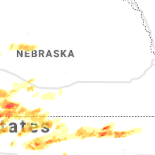

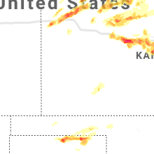


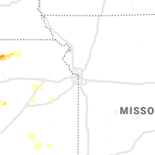


Cities Most Affected by Hail Storms of 5/26/2021
| Hail Size | Demographics of Zip Codes Affected | ||||||
|---|---|---|---|---|---|---|---|
| City | Count | Average | Largest | Pop Density | House Value | Income | Age |
| Hays, KS | 6 | 2.33 | 4.00 | 62 | $91k | $32.5k | 30.5 |
| Herndon, KS | 6 | 1.83 | 2.00 | 1 | $22k | $25.2k | 53.3 |
| Panhandle, TX | 4 | 2.38 | 2.50 | 1 | $58k | $41.5k | 39.8 |
| Gruver, TX | 3 | 2.58 | 3.00 | 0 | $61k | $33.2k | 36.0 |
| Geneseo, KS | 4 | 1.88 | 2.00 | 3 | $26k | $26.5k | 51.4 |
| Mcpherson, KS | 3 | 2.08 | 2.75 | 67 | $86k | $42.0k | 39.9 |
| Palisade, NE | 2 | 2.75 | 2.75 | 2 | $33k | $24.9k | 48.5 |
| Gurley, NE | 2 | 2.63 | 2.75 | 1 | $45k | $28.4k | 46.2 |
| Perryton, TX | 2 | 2.50 | 2.50 | 13 | $49k | $38.0k | 31.5 |
| Russell, KS | 2 | 2.13 | 2.50 | 15 | $46k | $30.2k | 45.3 |
| Wauneta, NE | 2 | 2.13 | 2.50 | 1 | $40k | $30.1k | 50.2 |
| Ellis, KS | 2 | 2.00 | 2.25 | 8 | $55k | $30.4k | 40.4 |
| Oberlin, KS | 2 | 1.75 | 1.75 | 5 | $49k | $31.7k | 50.5 |
| Goodland, KS | 1 | 2.50 | 2.50 | 9 | $65k | $33.1k | 41.5 |
| Brewster, KS | 1 | 2.50 | 2.50 | 1 | $42k | $36.6k | 43.3 |
| Victoria, KS | 1 | 2.00 | 2.00 | 8 | $70k | $33.5k | 42.6 |
| Upton, WY | 1 | 1.75 | 1.75 | 0 | $68k | $34.9k | 41.3 |
| Hale Center, TX | 1 | 1.75 | 1.75 | 4 | $42k | $29.2k | 36.0 |
| Hoxie, KS | 1 | 1.75 | 1.75 | 2 | $59k | $33.9k | 48.2 |
| Lyons, KS | 1 | 1.75 | 1.75 | 23 | $46k | $35.8k | 40.0 |
| Damar, KS | 1 | 1.75 | 1.75 | 2 | $25k | $27.5k | 43.8 |
| Norton, KS | 1 | 1.75 | 1.75 | 10 | $55k | $31.1k | 42.6 |
Hail and Wind Damage Spotted on 5/26/2021
Filter by Report Type:Hail ReportsWind Reports
States Impacted
Kansas, New York, Pennsylvania, Ohio, Virginia, West Virginia, Nebraska, Vermont, Maryland, Maine, Massachusetts, New Hampshire, Wyoming, New Jersey, Colorado, Texas, Connecticut, New Mexico, Oklahoma, District of ColumbiaKansas
| Local Time | Report Details |
|---|---|
| 9:06 AM MDT | Half Dollar sized hail reported near Brewster, KS, 21.5 miles WNW of Colby, KS |
| 9:12 AM MDT | Half Dollar sized hail reported near Goodland, KS, 38.1 miles WSW of Colby, KS, delayed report. |
| 9:18 AM MDT | Tennis Ball sized hail reported near Goodland, KS, 36.5 miles WSW of Colby, KS, delayed report. |
| 9:26 AM MDT | Quarter sized hail reported near Goodland, KS, 34 miles WSW of Colby, KS |
| 9:29 AM MDT | Quarter sized hail reported near Goodland, KS, 34.8 miles W of Colby, KS, report from mping: quarter (1.00 in.). |
| 9:30 AM MDT | Quarter sized hail reported near Goodland, KS, 37.1 miles W of Colby, KS |
| 11:08 AM CDT | Quarter sized hail reported near Brewster, KS, 17.8 miles WSW of Colby, KS |
| 11:08 AM CDT | Ping Pong Ball sized hail reported near Brewster, KS, 18 miles W of Colby, KS |
| 11:08 AM CDT | Ping Pong Ball sized hail reported near Brewster, KS, 17.8 miles WSW of Colby, KS, corrects previous hail report from 2 s brewster. |
| 11:37 AM CDT | Quarter sized hail reported near Colby, KS, 10.8 miles NW of Colby, KS, penny to quarter size hail covering the ground. |
| 11:52 AM CDT | Tennis Ball sized hail reported near Brewster, KS, 19.5 miles WNW of Colby, KS, storm chaser reported golf ball to tennis ball size hail. hail broke their windshield. |
| 1:13 PM CDT | Quarter sized hail reported near Wakeeney, KS, 30.5 miles WNW of Hays, KS |
| 1:25 PM CDT | Quarter sized hail reported near Ellis, KS, 13.2 miles WNW of Hays, KS |
| 1:28 PM CDT | Ping Pong Ball sized hail reported near Ellis, KS, 13.2 miles WNW of Hays, KS |
| 1:36 PM CDT | Half Dollar sized hail reported near Ellis, KS, 13.4 miles WNW of Hays, KS |
| 1:37 PM CDT | Golf Ball sized hail reported near Ellis, KS, 13.7 miles WNW of Hays, KS |
| 1:40 PM CDT | Hen Egg sized hail reported near Ellis, KS, 13.2 miles WNW of Hays, KS |
| 1:49 PM CDT | Ping Pong Ball sized hail reported near Ellis, KS, 13.2 miles WNW of Hays, KS |
| 2:00 PM CDT | Half Dollar sized hail reported near Hays, KS, 0.9 miles SSW of Hays, KS, report from mping: half dollar (1.25 in.). |
| 2:04 PM CDT | Quarter sized hail reported near Hays, KS, 4.6 miles NW of Hays, KS |
| 2:06 PM CDT | Quarter sized hail reported near Hays, KS, 0.1 miles ESE of Hays, KS, report from mping: quarter (1.00 in.). |
| 2:08 PM CDT | Baseball sized hail reported near Hays, KS, 0.9 miles NE of Hays, KS |
| 2:11 PM CDT | Quarter sized hail reported near Hays, KS, 2 miles N of Hays, KS, report from mping: quarter (1.00 in.). |
| 2:13 PM CDT | Hen Egg sized hail reported near Hays, KS, 2 miles N of Hays, KS, report from mping: hen egg (2.00 in.). |
| 2:13 PM CDT | Golf Ball sized hail reported near Hays, KS, 0.7 miles E of Hays, KS |
| 2:30 PM CDT | Grapefruit sized hail reported near Hays, KS, 1.6 miles SSE of Hays, KS, social media post. |
| 2:39 PM CDT | Quarter sized hail reported near Hays, KS, 2.3 miles SE of Hays, KS, report from mping: quarter (1.00 in.). |
| 2:41 PM CDT | Quarter sized hail reported near Hays, KS, 5.4 miles SE of Hays, KS |
| 2:41 PM CDT | Golf Ball sized hail reported near Hays, KS, 5.2 miles ESE of Hays, KS |
| 2:49 PM CDT | Quarter sized hail reported near Hays, KS, 2.3 miles SE of Hays, KS, report from mping: quarter (1.00 in.). |
| 2:56 PM CDT | Golf Ball sized hail reported near Hays, KS, 1.9 miles ESE of Hays, KS |
| 3:23 PM CDT | Hen Egg sized hail reported near Victoria, KS, 9.9 miles E of Hays, KS, report from mping: hen egg (2.00 in.). |
| 3:30 PM CDT | Quarter sized hail reported near Hays, KS, 11.1 miles S of Hays, KS |
| 3:30 PM CDT | Half Dollar sized hail reported near Hays, KS, 6.3 miles S of Hays, KS, report from mping: half dollar (1.25 in.). |
| 3:50 PM CDT | Quarter sized hail reported near Gorham, KS, 17 miles E of Hays, KS |
| 4:04 PM CDT | 60 to 70 mph winds in russell county KS, 28.2 miles E of Hays, KS |
| 4:06 PM CDT | Storm damage reported in russell county KS, 17.9 miles E of Hays, KS |
| 4:24 PM CDT | Half Dollar sized hail reported near Russell, KS, 22.3 miles E of Hays, KS, 60 mph winds were also reported along with an uprooted tree. |
| 4:25 PM CDT | 40 foot tall... 3ft wide elm tree blown over. delayed report. time estimated based on rada in russell county KS, 25.6 miles E of Hays, KS |
| 4:28 PM CDT | Dime sized hail also reported along with very heavy rai in russell county KS, 26.1 miles E of Hays, KS |
| 4:35 PM CDT | Tennis Ball sized hail reported near Russell, KS, 26 miles E of Hays, KS, delayed report. |
| 4:39 PM CDT | Ping Pong Ball sized hail reported near Russell, KS, 26 miles E of Hays, KS |
| 4:45 PM CDT | Golf Ball sized hail reported near Russell, KS, 26 miles E of Hays, KS, via social media pic. |
| 4:49 PM CDT | Half Dollar sized hail reported near Leoti, KS, 50.4 miles NNW of Garden City, KS, report from mping: half dollar (1.25 in.). |
| 4:52 PM CDT | Quarter sized hail reported near Leoti, KS, 50.9 miles NNW of Garden City, KS, report received of quarter sized hail north of leoti. |
| 5:31 PM CDT | Quarter sized hail reported near Monument, KS, 25 miles SSW of Colby, KS |
| 5:33 PM CDT | Quarter sized hail reported near Winona, KS, 25.5 miles SSW of Colby, KS |
| 5:49 PM CDT | Golf Ball sized hail reported near Herndon, KS, 43.8 miles NNE of Colby, KS |
| 5:59 PM CDT | Pws station kksglene3. in stratiform precip on north side of thunderstorm in mitchell county KS, 62.7 miles ENE of Hays, KS |
| 6:00 PM CDT | Quarter sized hail reported near Geneseo, KS, 72 miles ESE of Hays, KS |
| 6:05 PM CDT | Kansas mesonet wind gust in stratiform rain on north side of thunderstorm in mitchell county KS, 71.9 miles ENE of Hays, KS |
| 6:05 PM CDT | Quarter sized hail reported near Ellsworth, KS, 66.8 miles E of Hays, KS, 1.3 inches of rain and 40 mph winds with the storm as it passed. |
| 6:08 PM CDT | Quarter sized hail reported near Colby, KS, 11.6 miles S of Colby, KS, report from mping: quarter sized hail reported. |
| 6:12 PM CDT | Golf Ball sized hail reported near Oberlin, KS, 46.4 miles NNE of Colby, KS, hail ranged from penny to quarter with occasional golf ball. |
| 6:20 PM CDT | Delayed reports of power pole and tree damage in and around beloi in mitchell county KS, 77.2 miles ENE of Hays, KS |
| 6:24 PM CDT | Ping Pong Ball sized hail reported near Holyrood, KS, 53.5 miles ESE of Hays, KS |
| 6:35 PM CDT | Semi truck blown over on hwy 15 in ellsworth county KS, 53.5 miles ESE of Hays, KS |
| 6:43 PM CDT | Quarter sized hail reported near Geneseo, KS, 62.6 miles ESE of Hays, KS |
| 6:54 PM CDT | Half Dollar sized hail reported near Geneseo, KS, 67.8 miles ESE of Hays, KS |
| 6:54 PM CDT | Golf Ball sized hail reported near Lyons, KS, 68.1 miles NW of Wichita, KS, very heavy rain with the hail. |
| 6:56 PM CDT | Golf Ball sized hail reported near Geneseo, KS, 62.6 miles ESE of Hays, KS |
| 6:56 PM CDT | Storm damage reported in saline county KS, 64.4 miles WSW of Manhattan, KS |
| 6:57 PM CDT | Golf Ball sized hail reported near Geneseo, KS, 66.9 miles ESE of Hays, KS |
| 7:02 PM CDT | Power lines down in the city of salin in saline county KS, 61.4 miles WSW of Manhattan, KS |
| 7:05 PM CDT | Hen Egg sized hail reported near Geneseo, KS, 67.8 miles ESE of Hays, KS |
| 7:06 PM CDT | Ping Pong Ball sized hail reported near Geneseo, KS, 67.3 miles ESE of Hays, KS |
| 7:11 PM CDT | Quarter sized hail reported near Hoxie, KS, 32.5 miles E of Colby, KS, public report of quarter size hail. |
| 7:15 PM CDT | Half Dollar sized hail reported near Geneseo, KS, 68.1 miles ESE of Hays, KS |
| 7:21 PM CDT | Quarter sized hail reported near Colby, KS, 14.7 miles N of Colby, KS, report received via social media. |
| 7:22 PM CDT | Quarter sized hail reported near Montezuma, KS, 39.1 miles SSE of Garden City, KS |
| 7:23 PM CDT | Hen Egg sized hail reported near Geneseo, KS, 68.3 miles ESE of Hays, KS, relayed via kwch. |
| 7:25 PM CDT | Quarter sized hail reported near Geneseo, KS, 67.8 miles ESE of Hays, KS |
| 7:25 PM CDT | Quarter sized hail reported near Ensign, KS, 40.8 miles ESE of Garden City, KS |
| 7:30 PM CDT | Golf Ball sized hail reported near Hoxie, KS, 32.5 miles E of Colby, KS, delayed report via social media of hail up to golf ball size and a storm rain total of 0.16 inch. |
| 7:31 PM CDT | Half Dollar sized hail reported near Atwood, KS, 21.2 miles N of Colby, KS, report via twitter. |
| 7:33 PM CDT | A tree that was blown down took out power in the north part of tow in saline county KS, 62.1 miles WSW of Manhattan, KS |
| 7:52 PM CDT | Quarter sized hail reported near Jennings, KS, 47.1 miles ENE of Colby, KS |
| 7:53 PM CDT | Ping Pong Ball sized hail reported near Jennings, KS, 45.9 miles ENE of Colby, KS |
| 7:57 PM CDT | Hen Egg sized hail reported near Herndon, KS, 30.7 miles NNE of Colby, KS |
| 7:57 PM CDT | Hen Egg sized hail reported near Herndon, KS, 33.3 miles NNE of Colby, KS, delayed report. relayed via social media. hail measure 2.25 inches. |
| 7:58 PM CDT | Golf Ball sized hail reported near Herndon, KS, 32 miles NNE of Colby, KS |
| 8:00 PM CDT | Golf Ball sized hail reported near Herndon, KS, 32 miles NNE of Colby, KS |
| 8:04 PM CDT | Golf Ball sized hail reported near Herndon, KS, 30.8 miles NNE of Colby, KS |
| 8:05 PM CDT | Golf Ball sized hail reported near Oberlin, KS, 36.1 miles NNE of Colby, KS |
| 8:06 PM CDT | Ping Pong Ball sized hail reported near Herndon, KS, 33 miles NNE of Colby, KS |
| 8:07 PM CDT | 5 inch tree branches reported blown dow in saline county KS, 58.8 miles WSW of Manhattan, KS |
| 8:20 PM CDT | Quarter sized hail reported near Oberlin, KS, 40.4 miles NNE of Colby, KS, biggest hail stone just over 1 inch in diameter. |
| 8:36 PM CDT | Ping Pong Ball sized hail reported near Norton, KS, 65.1 miles ENE of Colby, KS |
| 8:36 PM CDT | Golf Ball sized hail reported near Norton, KS, 68.8 miles ENE of Colby, KS, delayed report via facebook. |
| 8:40 PM CDT | Quarter sized hail reported near Norton, KS, 68.8 miles ENE of Colby, KS |
| 8:43 PM CDT | Ping Pong Ball sized hail reported near Norton, KS, 66.1 miles ENE of Colby, KS, mainly nickel to quarter hail... a few ping pong ball hail stones mixed. |
| 8:43 PM CDT | Golf Ball sized hail reported near Mcpherson, KS, 50.3 miles NNW of Wichita, KS |
| 8:47 PM CDT | Golf Ball sized hail reported near Mcpherson, KS, 51 miles NNW of Wichita, KS, quarter to golf ball sized hail at mcpherson high school. |
| 8:50 PM CDT | Baseball sized hail reported near Mcpherson, KS, 50.5 miles NNW of Wichita, KS, delayed report via social media. |
| 9:07 PM CDT | Quarter sized hail reported near Inman, KS, 44.3 miles NNW of Wichita, KS |
| 9:20 PM CDT | Half Dollar sized hail reported near Mcpherson, KS, 49.3 miles NNW of Wichita, KS |
| 9:30 PM CDT | Also reported dime size hai in mcpherson county KS, 41.7 miles NNW of Wichita, KS |
| 9:44 PM CDT | Quarter sized hail reported near Hill City, KS, 43.9 miles NW of Hays, KS |
| 10:00 PM CDT | Quarter sized hail reported near Bogue, KS, 38.8 miles NNW of Hays, KS |
| 10:15 PM CDT | Golf Ball sized hail reported near Damar, KS, 33.7 miles NNW of Hays, KS, time estimated from radar. |
| 10:24 PM CDT | Quarter sized hail reported near Stockton, KS, 37 miles N of Hays, KS |
| 10:46 PM CDT | Ping Pong Ball sized hail reported near Stockton, KS, 37.3 miles N of Hays, KS, via twitter. |
| 3:56 AM UTC | Asos station kp28 medicine lodg in barber county KS, 72.4 miles WSW of Wichita, KS |
| 11:40 PM CDT | Storm damage reported in sedgwick county KS, 14.7 miles SW of Wichita, KS |
| 12:00 AM CDT | Storm damage reported in sedgwick county KS, 2.9 miles WNW of Wichita, KS |
| 5:01 AM UTC | Delayed report: numerous large tree limbs dow in sumner county KS, 16.6 miles S of Wichita, KS |
| 12:03 AM CDT | Storm damage reported in sedgwick county KS, 5.9 miles SE of Wichita, KS |
| 12:04 AM CDT | Storm damage reported in sedgwick county KS, 6 miles WSW of Wichita, KS |
| 5:08 AM UTC | Delayed report: large tree down over the roa in marion county KS, 54.7 miles SSW of Manhattan, KS |
| 12:14 AM CDT | Quarter sized hail reported near Beloit, KS, 74.6 miles NE of Hays, KS, ground is white with hail and many leaves stripped. |
| 12:15 AM CDT | Storm damage reported in sedgwick county KS, 4.2 miles ENE of Wichita, KS |
| 12:20 AM CDT | Delayed report: trees across roads and wind damage to home in marion county KS, 48.1 miles SW of Manhattan, KS |
| 12:24 AM CDT | Storm damage reported in sedgwick county KS, 7.7 miles NE of Wichita, KS |
| 12:25 AM CDT | Delayed report: 12-14 live tree snapped near the bas in cowley county KS, 29.1 miles SE of Wichita, KS |
| 5:31 AM UTC | 1-inch tree limbs broken; shingles blown of in butler county KS, 32.5 miles ENE of Wichita, KS |
| 12:40 AM CDT | Storm damage reported in sedgwick county KS, 5.9 miles SE of Wichita, KS |
| 5:50 AM UTC | Delayed report: very large tree (5-6 ft in diameter) down over the road. several other limbs and branches of 14+ inches in diameter broken in the are in butler county KS, 27.6 miles ENE of Wichita, KS |
| 12:55 AM CDT | 6-inch tree limbs down... e6 in butler county KS, 28.1 miles ENE of Wichita, KS |
| 6:13 AM UTC | Reported at manhattan regional airport aso in riley county KS, 6.4 miles WSW of Manhattan, KS |
| 6:25 AM UTC | Mesonet station fw6911 manhatta in pottawatomie county KS, 4.4 miles ENE of Manhattan, KS |
| 6:33 AM UTC | 1-inch tree limbs broken; shingles blown of in riley county KS, 0.1 miles NE of Manhattan, KS |
| 1:38 AM CDT | Asos station kcnk concordi in cloud county KS, 63.7 miles WNW of Manhattan, KS |
| 7:00 AM UTC | Downed tree limbs... time approximate in pottawatomie county KS, 10.1 miles NE of Manhattan, KS |
| 2:15 AM CDT | Downed power line... time approximate in pottawatomie county KS, 30 miles NE of Manhattan, KS |
| 2:22 AM CDT | Quarter sized hail reported near Clay Center, KS, 38.5 miles NW of Manhattan, KS |
| 8:00 AM UTC | Trees down... time estimate in marshall county KS, 35 miles N of Manhattan, KS |
New York
| Local Time | Report Details |
|---|---|
| 12:00 PM EDT | Trees and wires dow in wayne county NY, 44.1 miles WNW of Syracuse, NY |
| 12:06 PM EDT | Trees down in tow in wayne county NY, 35.7 miles WNW of Syracuse, NY |
| 12:22 PM EDT | *** 3 inj *** twitter video of a collapsed lumber building under construction. 3 injuries reported. estimated 50 knot wind gus in yates county NY, 53.6 miles WSW of Syracuse, NY |
| 12:35 PM EDT | Trees and wires down on merritt rd in granby. time estimated by rada in oswego county NY, 20.5 miles NW of Syracuse, NY |
| 12:46 PM EDT | Trees and wires down on route 45 in palermo. time estimated by rada in oswego county NY, 22.4 miles NNW of Syracuse, NY |
| 12:50 PM EDT | Trees blocking the road in cayuga county NY, 27.2 miles SSW of Syracuse, NY |
| 12:50 PM EDT | Trees down... trampoline thrown in cayuga county NY, 23 miles WSW of Syracuse, NY |
| 12:53 PM EDT | Trees and wires down in paris in oswego county NY, 24.2 miles N of Syracuse, NY |
| 1:00 PM EDT | Trees and wires down on s. albion rd... in the town of albio in oswego county NY, 31.3 miles NNE of Syracuse, NY |
| 1:05 PM EDT | Trees and wires down on whig hill rd... west monroe. time estimated by rada in oswego county NY, 17.7 miles NNE of Syracuse, NY |
| 1:05 PM EDT | Multiple reports of trees and wires down along slate hill road and route 2 in onondaga county NY, 11.3 miles SW of Syracuse, NY |
| 1:15 PM EDT | Large tree down on a vehicl in onondaga county NY, 2.2 miles SSW of Syracuse, NY |
| 1:16 PM EDT | Trees and wires down in osceola. time estimated by rada in lewis county NY, 37.8 miles NE of Syracuse, NY |
| 1:20 PM EDT | Twitter photo of trees dow in onondaga county NY, 6.2 miles SE of Syracuse, NY |
| 1:21 PM EDT | Trees and wires down in swancott mil in lewis county NY, 39.5 miles NE of Syracuse, NY |
| 1:28 PM EDT | Trees and wires down on james street in constableville. time estimated by rada in lewis county NY, 51 miles NE of Syracuse, NY |
| 1:30 PM EDT | Numerous trees and powerlines dow in onondaga county NY, 9.2 miles ESE of Syracuse, NY |
| 1:32 PM EDT | Trees and wires down in turin. time estimated by rada in lewis county NY, 54.6 miles NE of Syracuse, NY |
| 1:32 PM EDT | Trees and wires down in south turin. time estimated by rada in lewis county NY, 54.5 miles NE of Syracuse, NY |
| 1:32 PM EDT | Trees and wires down in west turin. time estimated by rada in lewis county NY, 53.9 miles NE of Syracuse, NY |
| 1:32 PM EDT | Tree and wires down on a hous in madison county NY, 12.8 miles ENE of Syracuse, NY |
| 1:35 PM EDT | Trees and wires down in lyons falls. time estimated by rada in lewis county NY, 55.9 miles NE of Syracuse, NY |
| 1:36 PM EDT | Trees and wires down. time estimated by rada in lewis county NY, 57.7 miles NE of Syracuse, NY |
| 1:40 PM EDT | Multiple reports of trees and wires dow in madison county NY, 19.2 miles ENE of Syracuse, NY |
| 1:45 PM EDT | Trees down on east grove stree in madison county NY, 25.3 miles E of Syracuse, NY |
| 1:48 PM EDT | Multiple reports of trees and wires down on several roads in the are in oneida county NY, 59.9 miles ENE of Syracuse, NY |
| 2:05 PM EDT | Tree on wires on beachview r in herkimer county NY, 72.7 miles SSE of Ogdensburg, NY |
| 2:10 PM EDT | Trees down on big moose r in herkimer county NY, 66.2 miles SSE of Ogdensburg, NY |
| 2:25 PM EDT | Trees down across beaver creek roa in madison county NY, 44.9 miles ESE of Syracuse, NY |
| 2:30 PM EDT | Tree and wires downed on route 30 at lewey lake campsite road in hamilton county NY, 62.1 miles NNW of Schenectady, NY |
| 2:30 PM EDT | Tree and wires down on piper rd in villag in herkimer county NY, 54.3 miles WNW of Schenectady, NY |
| 2:35 PM EDT | Trees and wires down in east frankfor in herkimer county NY, 55.1 miles E of Syracuse, NY |
| 2:40 PM EDT | Tree and wires dow in herkimer county NY, 46.5 miles WNW of Schenectady, NY |
| 3:06 PM EDT | Tree down on powerline on fredericks roa in broome county NY, 56.5 miles NNW of Scranton, PA |
| 3:18 PM EDT | Trees down on wires near old schroon roa in essex county NY, 55.4 miles SSW of Burlington, VT |
| 3:20 PM EDT | Tree down across davis r in broome county NY, 54.7 miles N of Scranton, PA |
| 3:22 PM EDT | Wires down on river roa in broome county NY, 53.3 miles N of Scranton, PA |
| 3:30 PM EDT | Large tree limbs down (> 2" in diameter) on the cross street of susan and edson from gust front ahead of thunderstorm in montgomery county NY, 12.6 miles NW of Schenectady, NY |
| 3:41 PM EDT | Limbs downed on campbell road in rotterdam due to gust front well ahead of thunderstorms in schenectady county NY, 2.5 miles W of Schenectady, NY |
| 3:42 PM EDT | Tree downed on wires. occurred with gust front well ahead of thunderstorm in schenectady county NY, 1.6 miles NW of Schenectady, NY |
| 3:44 PM EDT | Tree downed on wires. occurred with gust front well ahead of thunderstorm in schenectady county NY, 1 miles SSE of Schenectady, NY |
| 4:00 PM EDT | Large tree down on route 40 just south of mcdougall rd in washington county NY, 41.8 miles NE of Schenectady, NY |
| 4:06 PM EDT | Trees down on tilford rd in washington county NY, 42.8 miles NE of Schenectady, NY |
| 4:08 PM EDT | Tree down on route 30 near pope hill rd in washington county NY, 43.9 miles NE of Schenectady, NY |
| 4:24 PM EDT | Numerous trees and wires downed in buskirk in washington county NY, 28.3 miles ENE of Schenectady, NY |
| 6:00 PM EDT | Tree down in saugerties. time estimate in ulster county NY, 51.2 miles S of Schenectady, NY |
| 6:05 PM EDT | Trees down in kerhonkson. time estimate in ulster county NY, 73.6 miles SSW of Schenectady, NY |
| 6:15 PM EDT | Trees down in hurley. time estimate in ulster county NY, 62.6 miles S of Schenectady, NY |
| 6:20 PM EDT | Trees down in new paltz. time estimate in ulster county NY, 73.1 miles N of Brooklyn, NY |
| 6:30 PM EDT | Tree dow in broome county NY, 57.6 miles N of Scranton, PA |
| 6:30 PM EDT | Tree and wires down on ny 209 north of us 4 in ulster county NY, 72.8 miles ENE of Scranton, PA |
| 6:35 PM EDT | Taconics state parkway north to us 44 closed due to downed tre in dutchess county NY, 73.7 miles N of Brooklyn, NY |
| 7:42 PM EDT | Tree down on brefni street in north amityville. time estimated by rada in suffolk county NY, 30 miles E of Brooklyn, NY |
Pennsylvania
| Local Time | Report Details |
|---|---|
| 1:19 PM EDT | Quarter sized hail reported near Brockway, PA, 55.5 miles WNW of State College, PA |
| 2:10 PM EDT | Trees down on old main lawn on penn state campus at university par in centre county PA, 0.4 miles N of State College, PA |
| 2:12 PM EDT | Trees/wires down in state college borough and ferguson/college twp in centre county PA, 1.1 miles ESE of State College, PA |
| 2:30 PM EDT | Trees/wires down near liverpoo in perry county PA, 48.1 miles ESE of State College, PA |
| 2:33 PM EDT | Numerous trees reported to have been snapped near unityvill in lycoming county PA, 45.9 miles WSW of Scranton, PA |
| 2:35 PM EDT | Trees reported down in the reedsville are in mifflin county PA, 16.1 miles ESE of State College, PA |
| 2:35 PM EDT | Trees/wires down on light street in susquehanna tw in juniata county PA, 46.8 miles ESE of State College, PA |
| 2:36 PM EDT | Tree and wires dow in mercer county PA, 59.4 miles NNW of Pittsburgh, PA |
| 2:45 PM EDT | Quarter sized hail reported near Benton, PA, 40.1 miles WSW of Scranton, PA |
| 2:47 PM EDT | Trees/wires down near millerstow in perry county PA, 41 miles ESE of State College, PA |
| 2:49 PM EDT | Multiple trees and a barn blown down just north of berrysburg off of route 22 in dauphin county PA, 56.6 miles ESE of State College, PA |
| 2:58 PM EDT | Quarter sized hail reported near Benton, PA, 35.5 miles WSW of Scranton, PA |
| 3:16 PM EDT | Trees/wires down near new buffal in perry county PA, 52.7 miles ESE of State College, PA |
| 3:20 PM EDT | Trees down near route 147 and seiders road in halifax townshi in dauphin county PA, 53.5 miles ESE of State College, PA |
| 3:35 PM EDT | Trees down on rock road near natures road east of pine grov in schuylkill county PA, 69 miles SSW of Scranton, PA |
| 3:40 PM EDT | Large tree on a home in the 600 block of south 29th stree in dauphin county PA, 65.1 miles SE of State College, PA |
| 3:47 PM EDT | Trees down and pea-sized hail near millerstown road and black horse tavern roa in adams county PA, 49.8 miles NW of Baltimore, MD |
| 3:50 PM EDT | Trees and wires down on swift run road west of new oxfor in adams county PA, 48.1 miles NNW of Baltimore, MD |
| 3:55 PM EDT | Trees and wires down along route 72 north of jonestow in lebanon county PA, 74.9 miles ESE of State College, PA |
| 4:07 PM EDT | Corrects previous tstm wnd dmg report from center moreland. multiple reports of trees dow in wyoming county PA, 14 miles W of Scranton, PA |
| 4:11 PM EDT | Power pole snapped on holly road. time estimated from rada in berks county PA, 61.4 miles SSW of Scranton, PA |
| 8:13 PM UTC | Corrects previous tstm wnd dmg report from center moreland. corrects previous tstm wnd dmg report from center moreland. multiple reports of trees dow in wyoming county PA, 14 miles W of Scranton, PA |
| 4:19 PM EDT | Tree down in fayette county PA, 40.1 miles SSE of Pittsburgh, PA |
| 4:25 PM EDT | Downed tree on u.s. highway 222 near bernville road. time estimated from rada in berks county PA, 73.1 miles SSW of Scranton, PA |
| 4:27 PM EDT | Downed trees and wires near chapel hill road. time estimated from rada in berks county PA, 75.3 miles NNE of Baltimore, MD |
| 4:29 PM EDT | Tree limbs and wires down near westwood road. time estimated from rada in berks county PA, 75 miles SSW of Scranton, PA |
| 4:29 PM EDT | Mping reports of trees uprooted and power poles snapped near adam road. time estimated from rada in berks county PA, 62.1 miles S of Scranton, PA |
| 4:30 PM EDT | Social media video of a tree blowing down from strong wind in berks county PA, 64.2 miles S of Scranton, PA |
| 4:30 PM EDT | Tree dow in susquehanna county PA, 21.5 miles NNW of Scranton, PA |
| 4:30 PM EDT | Tree dow in susquehanna county PA, 21.5 miles N of Scranton, PA |
| 4:33 PM EDT | Downed tree on basket road. time estimated from rada in berks county PA, 70.2 miles S of Scranton, PA |
| 4:33 PM EDT | Mping report of tree limbs and wires dow in berks county PA, 66.2 miles S of Scranton, PA |
| 4:35 PM EDT | Downed trees and wires on kutztown road. time estimated from rada in berks county PA, 62.5 miles S of Scranton, PA |
| 4:35 PM EDT | Multiple trees down on crystal ridge road. time estimated from radar and dispatch repor in berks county PA, 62.1 miles S of Scranton, PA |
| 8:36 PM UTC | Corrects previous tstm wnd dmg report from west lenox. tree dow in susquehanna county PA, 21.5 miles N of Scranton, PA |
| 4:39 PM EDT | Several reports of downed trees and wires in the bowers area. time estimated from rada in berks county PA, 64.3 miles S of Scranton, PA |
| 4:40 PM EDT | Tree down reported with high winds and pea sized hai in berks county PA, 64.9 miles S of Scranton, PA |
| 4:48 PM EDT | Several reports of trees and wires down in the klines corner and maxatawny areas. time estimated from rada in berks county PA, 60.7 miles S of Scranton, PA |
| 4:48 PM EDT | Downed tree on powder mill hollow road. time estimated from rada in berks county PA, 75.3 miles S of Scranton, PA |
| 4:48 PM EDT | Mping report of downed tree limbs and power lines near old topton road. time estimated from rada in berks county PA, 62.1 miles S of Scranton, PA |
| 4:52 PM EDT | Mping report of downed tree limbs and power lines near valley road. time estimated from rada in berks county PA, 62.1 miles S of Scranton, PA |
| 4:54 PM EDT | Downed tree limbs and wires near hickory circle. time estimated from rada in lehigh county PA, 57.7 miles S of Scranton, PA |
| 4:55 PM EDT | Downed wires near haines mill road. time estimated from rada in lehigh county PA, 57.8 miles S of Scranton, PA |
| 4:55 PM EDT | Downed tree on ziegler road near gravel pike. time estimated from rada in montgomery county PA, 68.7 miles S of Scranton, PA |
| 4:55 PM EDT | Social media photo of a snapped tree in a neighborhood near allentown. time corrected based on rada in lehigh county PA, 56.8 miles S of Scranton, PA |
| 4:55 PM EDT | 6 homes along oakwood trail and dogwood trail damaged by strong wind gusts and fallen tree in lehigh county PA, 58.4 miles S of Scranton, PA |
| 4:58 PM EDT | Downed tree on reifsnyder road near swamp picnic road. time estimated from rada in montgomery county PA, 76.7 miles S of Scranton, PA |
| 4:58 PM EDT | Several reports of trees and wires down southwest of allentown. time estimated from rada in lehigh county PA, 58.4 miles S of Scranton, PA |
| 4:58 PM EDT | Downed trees and wires near kressler road. time estimated from rada in lehigh county PA, 58.3 miles S of Scranton, PA |
| 4:58 PM EDT | Downed tree in wires on kutztown road near township woods road. time estimated from rada in montgomery county PA, 69.9 miles S of Scranton, PA |
| 5:05 PM EDT | Downed tree on salford station road near cepp road. time estimated from rada in montgomery county PA, 77.9 miles S of Scranton, PA |
| 5:05 PM EDT | Several downed trees and a power pole down. time estimated from rada in montgomery county PA, 74.3 miles S of Scranton, PA |
| 5:05 PM EDT | Downed tree on ward road. time estimated from rada in montgomery county PA, 72.8 miles S of Scranton, PA |
| 5:05 PM EDT | Downed tree near the intersection of limeport pike and chestnut hill church road. time estimated from rada in lehigh county PA, 64.4 miles S of Scranton, PA |
| 5:07 PM EDT | Several reports of downed trees and wires near and west of sellersville. time estimated from rada in bucks county PA, 73.5 miles WSW of Brooklyn, NY |
| 5:08 PM EDT | Picture confirms tree damage with large branches down in mcmurra in washington county PA, 12 miles SSW of Pittsburgh, PA |
| 5:08 PM EDT | Multiple reports of trees and wires down in mt. lebanon. time estimated based on rada in allegheny county PA, 5.5 miles SSW of Pittsburgh, PA |
| 5:09 PM EDT | Downed trees and wires near mountain view road. time estimated from rada in bucks county PA, 73.2 miles SSE of Scranton, PA |
| 5:10 PM EDT | Downed tree limbs and wires near walnut lane. time estimated from rada in bucks county PA, 70.2 miles S of Scranton, PA |
| 5:12 PM EDT | Multiple small to medium sized branches down. estimated wind speed of 45 mp in washington county PA, 12.4 miles S of Pittsburgh, PA |
| 5:14 PM EDT | Downed trees and wires near front street. time estimated from rada in northampton county PA, 59.7 miles SSE of Scranton, PA |
| 5:15 PM EDT | Reports of trees down. time estimated based on rada in allegheny county PA, 6.1 miles ESE of Pittsburgh, PA |
| 5:15 PM EDT | Reports of trees down across city of pittsburgh. time estimated based on radar in allegheny county PA, 0.9 miles E of Pittsburgh, PA |
| 5:16 PM EDT | Report of tree branches down and blown over patio furniture in west mifflin. time estimated based on rada in allegheny county PA, 7.1 miles SE of Pittsburgh, PA |
| 5:16 PM EDT | Downed trees and wires near kellers road and mine road. time estimated from rada in bucks county PA, 65.4 miles SSE of Scranton, PA |
| 5:20 PM EDT | Broadcast meteorologist estimates 60-65 mph wind gusts near allentown road and county line roa in bucks county PA, 74 miles SSE of Scranton, PA |
| 5:20 PM EDT | Trees down in cooke tw in cumberland county PA, 60.4 miles SSE of State College, PA |
| 5:21 PM EDT | Downed trees and wires near county line road and business route 202. time estimated from rada in montgomery county PA, 71.5 miles WSW of Brooklyn, NY |
| 5:21 PM EDT | Downed trees and wires near river road and manor road. time estimated from rada in warren county NJ, 57.7 miles SSE of Scranton, PA |
| 5:22 PM EDT | Downed tree limbs and wires north of raubsville road. time estimated from rada in northampton county PA, 58.3 miles SSE of Scranton, PA |
| 5:23 PM EDT | Downed tree blocking overbrook drive near gwynedd valley drive. time estimated from rada in montgomery county PA, 75.7 miles WSW of Brooklyn, NY |
| 5:23 PM EDT | Downed trees and wires near harmony station road and river road. time estimated from rada in warren county NJ, 52.4 miles SSE of Scranton, PA |
| 5:27 PM EDT | Downed wires on wistar road near chetwynd road. time estimated from rada in chester county PA, 79 miles NE of Baltimore, MD |
| 5:27 PM EDT | Downed tree on buck drive near rabbit run lane. time estimated from rada in chester county PA, 72.9 miles NE of Baltimore, MD |
| 5:30 PM EDT | Downed tree limbs on fourth avenue and lincoln avenue. time estimated from rada in chester county PA, 82 miles NE of Baltimore, MD |
| 5:32 PM EDT | Downed tree on styer road near meadow creek lane. time estimated from rada in chester county PA, 72.7 miles NE of Baltimore, MD |
| 5:32 PM EDT | Report of tree down blocking the road. time estiamted based on rada in westmoreland county PA, 16.6 miles ESE of Pittsburgh, PA |
| 5:34 PM EDT | Report of tree down blocking roadway. time estimated based on rada in westmoreland county PA, 18.5 miles E of Pittsburgh, PA |
| 5:37 PM EDT | Multiple reports of trees and wires down blocking roadways. time estimated based on rada in westmoreland county PA, 17.8 miles E of Pittsburgh, PA |
| 5:39 PM EDT | Downed tree limbs on davisville road and danielle drive. time estimated from rada in montgomery county PA, 68.6 miles WSW of Brooklyn, NY |
| 5:44 PM EDT | Downed trees and wires near sixth street and market street. time estimated from rada in chester county PA, 48.5 miles NE of Baltimore, MD |
| 5:46 PM EDT | Report of trees and powerlines down along with a blown off roof in greensbur in westmoreland county PA, 25.7 miles ESE of Pittsburgh, PA |
| 5:48 PM EDT | Multiple reports of trees and wires down blocking roadways in hempfield township. time estimated based on rada in westmoreland county PA, 27.2 miles ESE of Pittsburgh, PA |
| 5:49 PM EDT | Downed wires near loop road. time estimated from rada in chester county PA, 50.5 miles NE of Baltimore, MD |
| 5:52 PM EDT | Downed tree limbs and wires near mindy drive. time estimated from rada in chester county PA, 55.3 miles NE of Baltimore, MD |
| 5:54 PM EDT | Downed tree limbs and wires near daleville road. time estimated from rada in chester county PA, 55.3 miles NE of Baltimore, MD |
| 5:56 PM EDT | Mping report of wind damage near glenloch street. time estimated from rada in philadelphia county PA, 72.2 miles SW of Brooklyn, NY |
| 6:03 PM EDT | Report of trees and wires down blocking sunview circle in derry township. time estimated based on rada in westmoreland county PA, 37.6 miles ESE of Pittsburgh, PA |
| 6:20 PM EDT | Report of several snapped trees and downed branche in westmoreland county PA, 48.6 miles E of Pittsburgh, PA |
| 6:31 PM EDT | Trees down along bracken street in mundys corne in cambria county PA, 57.5 miles WSW of State College, PA |
| 6:50 PM EDT | Trees down on old rt 22 near healy r in blair county PA, 42.9 miles WSW of State College, PA |
| 6:55 PM EDT | Trees down in the hollidaysburg are in blair county PA, 37.9 miles SW of State College, PA |
| 7:05 PM EDT | Tree down blocking state route 92. oakland townshi in susquehanna county PA, 36 miles N of Scranton, PA |
| 7:26 PM EDT | Delayed mping report of 3-inch tree limbs; power poles broken. time estimated based on rada in berks county PA, 62.1 miles S of Scranton, PA |
| 7:40 PM EDT | Numerous large trees down in longs park. trailer blown across harrisburg pik in lancaster county PA, 55 miles NNE of Baltimore, MD |
| 8:00 PM EDT | Trees and wires down between mifflintown and mcallistervill in juniata county PA, 30.6 miles ESE of State College, PA |
| 8:11 PM EDT | Trees and wires dow in juniata county PA, 36.4 miles ESE of State College, PA |
| 8:40 PM EDT | Trees down in middlesex and silver spring twp in cumberland county PA, 55.4 miles SE of State College, PA |
| 9:00 PM EDT | Numerous trees down in hegins tw in schuylkill county PA, 68.4 miles SW of Scranton, PA |
Ohio
| Local Time | Report Details |
|---|---|
| 1:24 PM EDT | Corrects previous tstm wnd dmg report from akron. corrects previous tstm wnd dmg report. 1 tree uprooted along southeast av in summit county OH, 30.6 miles SSE of Cleveland, OH |
| 1:25 PM EDT | Corrects previous tstm wnd dmg report from akron. tree down on lansing drive by baker avenue. large tree down on a ca in summit county OH, 30.6 miles SSE of Cleveland, OH |
| 1:34 PM EDT | Numerous trees down between i-76 and rt 22 in portage county OH, 33.6 miles SSE of Cleveland, OH |
| 1:34 PM EDT | Picture of tree down on route 43 near saxe road with other trees down in the are in portage county OH, 34.8 miles SSE of Cleveland, OH |
| 1:41 PM EDT | 1 tree uproote in summit county OH, 30.6 miles SSE of Cleveland, OH |
| 1:41 PM EDT | 1 tree uproote in summit county OH, 30.6 miles SSE of Cleveland, OH |
| 1:42 PM EDT | Tree down on lansing drive by baker avenue. large tree down on a ca in summit county OH, 30.6 miles SSE of Cleveland, OH |
Virginia
| Local Time | Report Details |
|---|---|
| 2:38 PM EDT | Tree and wires blew down on swimley road near the west virginia state lin in clarke county VA, 75.7 miles W of Baltimore, MD |
| 3:17 PM EDT | Numerous trees down in the vicinity of the apple blossom mall in city of winchester county VA, 84.2 miles W of Baltimore, MD |
| 3:17 PM EDT | Powerlines down and traffic lights down near the intersection of hillcrest avenue and massanutten terrace in city of winchester county VA, 85.3 miles W of Baltimore, MD |
| 3:19 PM EDT | Numerous trees down near the intersection of adam drive and south pleasant valley road in city of winchester county VA, 84.2 miles W of Baltimore, MD |
| 3:33 PM EDT | Several reports of trees down in the lovettsville and taylorstown are in loudoun county VA, 52.1 miles W of Baltimore, MD |
| 4:16 PM EDT | Wset lynchburg relayed a report from a viewer of several large trees down along pauls road approximately 3 miles southeast of rustburg. time of report estimated by rada in campbell county VA, 48.6 miles E of Roanoke, VA |
| 4:19 PM EDT | Two trees blew down... siding blew off building... and fence blew over near intersection of golders green place and scottish hunt lan in prince william county VA, 64.2 miles SW of Baltimore, MD |
| 4:23 PM EDT | Quarter sized hail reported near Gainesville, VA, 64.7 miles WSW of Baltimore, MD |
| 4:30 PM EDT | Large tree down on the 40000 block of featherbed lane in loudoun county VA, 53.8 miles W of Baltimore, MD |
| 4:32 PM EDT | Tree blew down on fairview avenue next to the manassas police statio in prince william county VA, 59 miles SW of Baltimore, MD |
| 4:35 PM EDT | Multiple tree limbs broken off trees at the intersection of sudley road and centerville roa in prince william county VA, 59 miles SW of Baltimore, MD |
| 4:35 PM EDT | Tree fell on mobile home and destroyed i in prince william county VA, 58.6 miles SW of Baltimore, MD |
| 4:37 PM EDT | Large tree down on the 12000 block of loft court in prince william county VA, 63.3 miles SW of Baltimore, MD |
| 4:38 PM EDT | Numerous trees down on the 9000 block of centreville roa in prince william county VA, 58.6 miles SW of Baltimore, MD |
| 4:40 PM EDT | Quarter sized hail reported near Manassas, VA, 59.9 miles SW of Baltimore, MD |
| 4:42 PM EDT | Quarter sized hail reported near Manassas, VA, 57.7 miles SW of Baltimore, MD |
| 5:06 PM EDT | Large tree down across the 1700 block of west braddock road in city of alexandria county VA, 41 miles SW of Baltimore, MD |
| 5:08 PM EDT | Tree blew down on south arlington ridge road between 20th street and i-39 in arlington county VA, 38.7 miles SW of Baltimore, MD |
| 5:12 PM EDT | Tree and power lines blew down on mt vernon ave in city of alexandria county VA, 40 miles SW of Baltimore, MD |
| 5:26 PM EDT | Large tree down near the intersection of mt. vernon hwy and old mt. vernon hw in fairfax county VA, 46.5 miles SW of Baltimore, MD |
| 6:05 PM EDT | Large tree down on the 2000 block of n. glebe road in arlington county VA, 38.5 miles SW of Baltimore, MD |
| 6:56 PM EDT | Tree blew down in the 1040 block of milldale roa in warren county VA, 83.2 miles WSW of Baltimore, MD |
| 7:01 PM EDT | Tree blew down in the 3100 block of port republic roa in rockingham county VA, 65.2 miles SE of Elkins, WV |
| 7:01 PM EDT | Multiple trees down on va 671 near neersvill in loudoun county VA, 60.1 miles W of Baltimore, MD |
| 7:04 PM EDT | Tree blew down on branchriver road near buzzard rock roa in loudoun county VA, 59 miles W of Baltimore, MD |
| 7:06 PM EDT | Tree blew down on irish corner road near mountain roa in loudoun county VA, 56.9 miles W of Baltimore, MD |
| 7:11 PM EDT | Tree blew down on route 663 near berlin turnpike (va 287 in loudoun county VA, 54.7 miles W of Baltimore, MD |
| 7:20 PM EDT | Tree blew down in the 4500 block of berrytown roa in rockingham county VA, 75 miles ESE of Elkins, WV |
| 7:30 PM EDT | Numerous trees and powerlines down near the intersection of windfields service lane and state rout 734/snickersville turnpike in loudoun county VA, 60.9 miles WSW of Baltimore, MD |
| 7:31 PM EDT | Tree and wires blew down in the 18000 block of red brush roa in rockingham county VA, 76.1 miles ESE of Elkins, WV |
| 7:31 PM EDT | Tree blew down on va 734 east (snickersville turnpike)near sam fred roa in loudoun county VA, 61.7 miles WSW of Baltimore, MD |
| 7:37 PM EDT | A tree blew down in the 13000 block of va-635 hume roa in fauquier county VA, 83.2 miles WSW of Baltimore, MD |
| 7:54 PM EDT | Tree blew down on parapet way near oxon roa in fairfax county VA, 50.2 miles WSW of Baltimore, MD |
| 8:01 PM EDT | A tree blew down on va-674 georgetown roa in fauquier county VA, 68.4 miles WSW of Baltimore, MD |
| 8:12 PM EDT | Tree blew down on canal road near arizona ave northwes in district of columb county DC, 37.1 miles SW of Baltimore, MD |
| 8:16 PM EDT | Tree blew down on the right lane of i-66 westbound just after the rosslyn tunne in arlington county VA, 36.6 miles SW of Baltimore, MD |
| 8:20 PM EDT | A tree blew down near the intersection of us-17 james madison highway and va-628 keith road. a tree blew down on va-647 crest hill roa in fauquier county VA, 75.1 miles WSW of Baltimore, MD |
| 8:51 PM EDT | Tree down on canal road nw east of arizona ave nw in district of columb county DC, 37.2 miles SW of Baltimore, MD |
| 8:55 PM EDT | There were about half a dozen trees blown down in the springfield... burke and annandale are in fairfax county VA, 46.2 miles SW of Baltimore, MD |
| 9:09 PM EDT | Storm damage reported in fairfax county VA, 50.5 miles SW of Baltimore, MD |
| 9:13 PM EDT | Storm damage reported in anz536 county VA, 55.6 miles SW of Baltimore, MD |
West Virginia
| Local Time | Report Details |
|---|---|
| 3:00 PM EDT | 12 telephone poles blew down on middleway pike just west of charles tow in jefferson county WV, 67.6 miles W of Baltimore, MD |
| 3:02 PM EDT | Tree and wires blew down on 4th street in charles tow in jefferson county WV, 66.5 miles W of Baltimore, MD |
| 3:03 PM EDT | Two trees blew down on east washington street in charles tow in jefferson county WV, 67 miles W of Baltimore, MD |
| 3:22 PM EDT | A few trees dow in monongalia county WV, 43.9 miles N of Elkins, WV |
| 3:27 PM EDT | Tree and power lines down in monongalia county WV, 44.2 miles N of Elkins, WV |
| 6:43 PM EDT | Tree blew down on fegan roa in berkeley county WV, 78.3 miles W of Baltimore, MD |
Nebraska
| Local Time | Report Details |
|---|---|
| 2:15 PM CDT | Quarter sized hail reported near Hershey, NE, 24.1 miles NW of North Platte, NE, delayed report. |
| 3:16 PM MDT | Half Dollar sized hail reported near Harrison, NE, 40.6 miles N of Scottsbluff, NE |
| 3:46 PM MDT | Half Dollar sized hail reported near Benkelman, NE, 56.2 miles NNW of Colby, KS, delayed report by trained spotter. |
| 3:48 PM MDT | Power outages at red cloud campground and tree limb broke in sioux county NE, 55.9 miles N of Scottsbluff, NE |
| 3:48 PM MDT | Quarter sized hail reported near Chadron, NE, 76.1 miles NNE of Scottsbluff, NE |
| 4:19 PM MDT | Golf Ball sized hail reported near Wauneta, NE, 64.1 miles NNW of Colby, KS |
| 4:25 PM MDT | Tennis Ball sized hail reported near Wauneta, NE, 64.1 miles NNW of Colby, KS |
| 5:26 PM CDT | Quarter sized hail reported near Moorefield, NE, 40.2 miles SSE of North Platte, NE, time estimated from radar. |
| 5:27 PM CDT | Quarter sized hail reported near Cozad, NE, 50.1 miles ESE of North Platte, NE, report from mping: quarter (1.00 in.). |
| 5:58 PM CDT | Baseball sized hail reported near Palisade, NE, 57.7 miles SSW of North Platte, NE, report via spotter network |
| 4:58 PM MDT | Quarter sized hail reported near Chadron, NE, 64.7 miles NNE of Scottsbluff, NE |
| 11:02 PM UTC | Quarter sized hail reported near Harrison, NE, 39.8 miles N of Scottsbluff, NE, hail reported falling from 502 to 506 pm. |
| 5:15 PM MDT | Quarter sized hail reported near Gurley, NE, 51.5 miles SE of Scottsbluff, NE |
| 5:15 PM MDT | Baseball sized hail reported near Gurley, NE, 51.8 miles SE of Scottsbluff, NE |
| 5:30 PM MDT | Quarter sized hail reported near Gurley, NE, 51.8 miles SE of Scottsbluff, NE |
| 5:30 PM MDT | Tennis Ball sized hail reported near Gurley, NE, 51.8 miles SE of Scottsbluff, NE |
| 5:40 PM MDT | Quarter sized hail reported near Dalton, NE, 50 miles ESE of Scottsbluff, NE |
| 5:46 PM MDT | From 543 to 546 pm md in dawes county NE, 73.4 miles NNE of Scottsbluff, NE |
| 5:52 PM MDT | Storm damage reported in cheyenne county NE, 64.3 miles N of Yuma, CO |
| 6:05 PM MDT | Quarter sized hail reported near Lodgepole, NE, 71.3 miles N of Yuma, CO |
| 6:25 PM MDT | Quarter sized hail reported near Alliance, NE, 57 miles NE of Scottsbluff, NE |
| 7:04 PM MDT | Quarter sized hail reported near Gordon, NE, 76.7 miles WSW of Valentine, NE |
| 8:05 PM CDT | Quarter sized hail reported near Palisade, NE, 54.9 miles SSW of North Platte, NE, report from mping: quarter (1.00 in.). |
| 8:18 PM CDT | Quarter sized hail reported near Palisade, NE, 53.5 miles SSW of North Platte, NE, 1 inch hail reported by trained spotter |
| 8:23 PM CDT | Baseball sized hail reported near Palisade, NE, 59.4 miles SSW of North Platte, NE, golf ball to baseball size hail reported. |
| 7:31 PM MDT | Quarter sized hail reported near Grant, NE, 54.3 miles WSW of North Platte, NE |
| 7:52 PM MDT | Storm damage reported in arthur county NE, 46.2 miles WNW of North Platte, NE |
| 7:52 PM MDT | Storm damage reported in arthur county NE, 60.3 miles WNW of North Platte, NE |
| 8:57 PM CDT | Nedor rwis statio in kearney county NE, 48.3 miles SW of Grand Island, NE |
| 9:30 PM CDT | Report from mping: 1-inch tree limbs broken; shingles blown of in red willow county NE, 60.1 miles NNE of Colby, KS |
| 10:48 PM CDT | Davis weatherlink statio in phelps county NE, 59.7 miles WSW of Grand Island, NE |
Vermont
| Local Time | Report Details |
|---|---|
| 3:50 PM EDT | Several reports of scattered trees and powerlines down in most sections of middlebury... including court street and route 116 in addison county VT, 32.3 miles S of Burlington, VT |
| 4:12 PM EDT | Several 12 inch diameter branches downed by thunderstorm wind in washington county VT, 28.2 miles SE of Burlington, VT |
| 4:20 PM EDT | Numerous reports of power outages from barre through marshfield beginning at 420 pm to 445 p in washington county VT, 39.7 miles ESE of Burlington, VT |
| 4:27 PM EDT | Numerous trees downed on route 14 in barr in washington county VT, 39.8 miles ESE of Burlington, VT |
| 4:28 PM EDT | Trees downed on route 313 on the new york-vermont border in bennington county VT, 40.2 miles ENE of Schenectady, NY |
| 4:33 PM EDT | Trees and wires down... with trees snapped 15 to 20 feet above the groun in washington county VT, 38.5 miles ESE of Burlington, VT |
| 4:35 PM EDT | Trees and powerlines down on school st/route 2 in plainfiel in washington county VT, 41.5 miles ESE of Burlington, VT |
| 4:36 PM EDT | Numerous trees and wires downed on route 7a in arlington in bennington county VT, 43.1 miles ENE of Schenectady, NY |
| 4:38 PM EDT | Tree downed on car near arlington fire station in bennington county VT, 44.1 miles ENE of Schenectady, NY |
| 4:47 PM EDT | Tree limbs down on danville hill rd in east cabo in washington county VT, 47 miles E of Burlington, VT |
| 4:50 PM EDT | Trees and wires down in caledonia county VT, 53.2 miles ESE of Burlington, VT |
| 4:51 PM EDT | Corrected time of report. peacham road in caledonia county VT, 54 miles E of Burlington, VT |
| 5:00 PM EDT | Trees and wires down in caledonia county VT, 58.9 miles ESE of Burlington, VT |
| 5:15 PM EDT | Large tree down in windham county VT, 71.6 miles ENE of Schenectady, NY |
| 5:20 PM EDT | Tree down on herring hill rd in windham county VT, 70.7 miles ENE of Schenectady, NY |
| 5:30 PM EDT | Tree down near exit 2 northbound on i-91 in windham county VT, 69.7 miles E of Schenectady, NY |
| 5:51 PM EDT | Peacham road in caledonia county VT, 53.4 miles E of Burlington, VT |
Maryland
| Local Time | Report Details |
|---|---|
| 3:59 PM EDT | Tree and wires down near intersection of haughs church road and detour roa in frederick county MD, 41.4 miles WNW of Baltimore, MD |
| 5:17 PM EDT | Two trees fell onto two different apartment buildings in the 3000 block of oak green circl in howard county MD, 10.2 miles W of Baltimore, MD |
| 5:26 PM EDT | Tree blew down onto one lane of us 40 near nuwood driv in baltimore county MD, 7.6 miles W of Baltimore, MD |
| 5:30 PM EDT | Large tree branches down across road in howard county MD, 15.3 miles SW of Baltimore, MD |
| 5:35 PM EDT | Tree branches and trees down on murray hill road near the middle patuxent river to the intersection of vollmerhausen roa in howard county MD, 15.7 miles SW of Baltimore, MD |
| 5:35 PM EDT | Tree blew down on md 210 south at old fort roa in prince georges county MD, 41.9 miles SSW of Baltimore, MD |
| 5:40 PM EDT | *** 1 inj *** tree down on home in 13300 block of pendleton street in fort washingto in prince georges county MD, 31 miles SSW of Baltimore, MD |
| 5:40 PM EDT | Multiple trees blew down in the southern portion of prince george's county near fort washingto in prince georges county MD, 45.6 miles SSW of Baltimore, MD |
| 5:40 PM EDT | Tree blew down on md 223 north past gallahan roa in prince georges county MD, 44.9 miles SSW of Baltimore, MD |
| 5:40 PM EDT | *** 1 inj *** tree down on home in 13300 block of pendleton street in fort washingto in prince georges county MD, 45 miles SSW of Baltimore, MD |
| 5:42 PM EDT | Numerous trees and wires down in the ft. washington park area in prince georges county MD, 45.7 miles SSW of Baltimore, MD |
| 5:42 PM EDT | Tree down on house on the 13000 block of pendleton street in prince georges county MD, 45 miles SSW of Baltimore, MD |
| 5:42 PM EDT | Quarter sized hail reported near Elkridge, MD, 11.9 miles SW of Baltimore, MD |
| 5:44 PM EDT | Tree blew down onto an occupied car in the 10900 block of sweetgum way. occupant safely out of ca in prince georges county MD, 31 miles SSW of Baltimore, MD |
| 5:44 PM EDT | Quarter sized hail reported near Columbia, MD, 12 miles WSW of Baltimore, MD |
| 5:46 PM EDT | Partial structure collapse of the frame of a new building under construction in the 3700 block of crain highwa in prince georges county MD, 31.8 miles SSW of Baltimore, MD |
| 5:54 PM EDT | Tree blew down on md 295 south at ridge roa in anne arundel county MD, 6.4 miles SSW of Baltimore, MD |
| 6:03 PM EDT | Tree fell across roadway on furnace r in anne arundel county MD, 7.6 miles S of Baltimore, MD |
| 6:25 PM EDT | Numerous trees down between the 1800 and 2000 block of nobles mill road in harford county MD, 30 miles NE of Baltimore, MD |
| 6:48 PM EDT | Tree down near the intersection of indian head highway and old fort road south in charles county MD, 56.1 miles SSW of Baltimore, MD |
| 6:52 PM EDT | Tree blew down on md 273 near lewisville roa in cecil county MD, 48.6 miles NE of Baltimore, MD |
| 7:00 PM EDT | Tree down on the 9000 block of md-223/piscataway road in prince georges county MD, 39.2 miles SSW of Baltimore, MD |
| 7:12 PM EDT | Tree blew down on md 478 near moore stree in frederick county MD, 55.8 miles W of Baltimore, MD |
| 7:13 PM EDT | Powerlines down on the 3000 block of petersville road in frederick county MD, 53.7 miles W of Baltimore, MD |
| 7:35 PM EDT | Roof partially blown off barn in the 14000 block of weller road. a couple of trees also blew dow in washington county MD, 75.7 miles S of State College, PA |
| 7:45 PM EDT | About a dozen calls for trees and wires down in the mount airy are in carroll county MD, 30 miles W of Baltimore, MD |
| 7:50 PM EDT | Tree down on livingston road south of medinah ridge road in prince georges county MD, 45.4 miles SSW of Baltimore, MD |
| 7:54 PM EDT | Tree blew down on md 97 south near md 3 in carroll county MD, 25.8 miles NW of Baltimore, MD |
| 7:55 PM EDT | About a dozen calls for trees and wires down in the sykesville are in carroll county MD, 20.6 miles WNW of Baltimore, MD |
| 8:03 PM EDT | 5 trees blew down in the reiserstown/owings mills are in baltimore county MD, 17.1 miles NW of Baltimore, MD |
| 8:03 PM EDT | Tree blew down on md 30 south near kemp roa in baltimore county MD, 18.1 miles NW of Baltimore, MD |
| 8:12 PM EDT | Multiple trees and wires down in the cabin john are in montgomery county MD, 36.9 miles SW of Baltimore, MD |
| 8:14 PM EDT | Tree down on transformer on 8000 block of block river road in montgomery county MD, 36.6 miles WSW of Baltimore, MD |
| 8:18 PM EDT | Tree and wires down blocking road near the intersection of persimmon tree road and holly leaf lane in montgomery county MD, 37 miles SW of Baltimore, MD |
| 8:20 PM EDT | Wires down on the 8000 block of maple avenue in montgomery county MD, 33.5 miles SW of Baltimore, MD |
| 8:22 PM EDT | Wires down on the 7000 block of wisconsin avenue in montgomery county MD, 33.5 miles SW of Baltimore, MD |
| 8:30 PM EDT | Tree down at the 4600 block of windsor av in baltimore city county MD, 4 miles WNW of Baltimore, MD |
| 8:33 PM EDT | Wires down near the intersection of walhonding road and tuscarawas road in montgomery county MD, 35.7 miles SW of Baltimore, MD |
| 8:40 PM EDT | Tree blew down on md 4 north near water stree in prince georges county MD, 34 miles SSW of Baltimore, MD |
| 9:16 PM EDT | Tree blew down on marshall hall roa in charles county MD, 51.9 miles SSW of Baltimore, MD |
Maine
| Local Time | Report Details |
|---|---|
| 4:28 PM EDT | Large tree down from estimated 50mph wind gust. time estimated by rada in aroostook county ME, 51.7 miles S of Caribou, ME |
| 6:52 PM EDT | Trees and wires down on ossipee hill rd. time estimated by rada in york county ME, 24.4 miles WSW of Portland, ME |
| 7:09 PM EDT | Multiple reports of trees down around lake arrowhead and trees on boat in york county ME, 24.7 miles W of Portland, ME |
| 7:10 PM EDT | West road closed due to trees on roadwa in york county ME, 26.1 miles WSW of Portland, ME |
| 7:12 PM EDT | Pictures on social media of large tree fell into home on glenwood ave. time estimated from rada in cumberland county ME, 9.3 miles W of Portland, ME |
| 7:20 PM EDT | Corrects previous non-tstm wnd dmg report from 1 ne westbrook to tstm wind damage. tree across park road in westbroo in cumberland county ME, 5.1 miles WNW of Portland, ME |
Massachusetts
| Local Time | Report Details |
|---|---|
| 5:15 PM EDT | Large tree dow in berkshire county MA, 49.8 miles ESE of Schenectady, NY |
| 5:52 PM EDT | Large tree down on eden trail road in franklin county MA, 67.6 miles E of Schenectady, NY |
| 6:00 PM EDT | Tree down on cross street in franklin county MA, 71.5 miles E of Schenectady, NY |
| 6:02 PM EDT | Tree and wires down on emerson gorham road in hampshire county MA, 67.5 miles SE of Schenectady, NY |
| 6:35 PM EDT | Tree down on jones road in hampshire county MA, 64.5 miles NW of Providence, RI |
| 6:39 PM EDT | Tree down on amherst road in hampshire county MA, 64.5 miles NW of Providence, RI |
| 7:20 PM EDT | Multiple trees down on north branch parkway in hampden county MA, 61.6 miles WNW of Providence, RI |
New Hampshire
| Local Time | Report Details |
|---|---|
| 5:20 PM EDT | Trees down off of hwy 30 in grafton county NH, 71 miles E of Burlington, VT |
| 5:24 PM EDT | Several trees dow in sullivan county NH, 81.8 miles SSE of Burlington, VT |
| 5:25 PM EDT | Large branches down across route 3 with penny size hai in grafton county NH, 79.4 miles WNW of Portland, ME |
| 5:40 PM EDT | Delayed report. maple tree snapped 40 feet above groun in cheshire county NH, 77.5 miles E of Schenectady, NY |
| 5:42 PM EDT | Trees and wires down on ball park r in sullivan county NH, 96.7 miles ENE of Schenectady, NY |
| 5:48 PM EDT | Trees... large branches and other debris scattered across hwy 32 near south r in cheshire county NH, 83.6 miles NNW of Providence, RI |
| 5:48 PM EDT | Several trees and power lines dow in sullivan county NH, 88.2 miles SSE of Burlington, VT |
| 5:51 PM EDT | Several trees dow in sullivan county NH, 92.4 miles SE of Burlington, VT |
| 5:53 PM EDT | Several trees dow in cheshire county NH, 94.4 miles NNW of Providence, RI |
| 5:54 PM EDT | Trees and wires dow in merrimack county NH, 74.2 miles W of Portland, ME |
| 6:06 PM EDT | Several trees and wires dow in merrimack county NH, 82.8 miles WSW of Portland, ME |
| 6:06 PM EDT | Trees and branches down east of sandwich and moultonboroug in carroll county NH, 56.2 miles W of Portland, ME |
| 6:10 PM EDT | Trees and wires down at diane drive and peter c in belknap county NH, 62.7 miles W of Portland, ME |
| 6:10 PM EDT | Trees and wires dow in merrimack county NH, 79.9 miles W of Portland, ME |
| 6:11 PM EDT | Large tree down blocking tannery hill rd and middle hancock rd. time estimated based on rada in hillsborough county NH, 82.2 miles NNW of Providence, RI |
| 6:11 PM EDT | Trees and wires down on bryant and proctor rd in jaffrey. time estimated based on rada in cheshire county NH, 76.7 miles NNW of Providence, RI |
| 6:15 PM EDT | Tree and wires down. time estimated based on rada in belknap county NH, 56.1 miles W of Portland, ME |
| 6:15 PM EDT | Several trees and wires dow in belknap county NH, 64.3 miles W of Portland, ME |
| 6:18 PM EDT | Trees and wires dow in belknap county NH, 61.6 miles W of Portland, ME |
| 6:23 PM EDT | Measured by a personal weather statio in belknap county NH, 55.3 miles W of Portland, ME |
| 6:24 PM EDT | Trees and wires dow in hillsborough county NH, 92.8 miles NNW of Providence, RI |
| 6:50 PM EDT | Trees down on nutes r in strafford county NH, 39.8 miles WSW of Portland, ME |
Wyoming
| Local Time | Report Details |
|---|---|
| 3:31 PM MDT | Storm damage reported in campbell county WY, 25 miles SSE of Gillette, WY |
| 4:15 PM MDT | Storm damage reported in campbell county WY, 55.3 miles SSE of Gillette, WY |
| 4:16 PM MDT | Golf Ball sized hail reported near Upton, WY, 40.1 miles ESE of Gillette, WY |
| 4:57 PM MDT | Quarter sized hail reported near Newcastle, WY, 47.8 miles W of Rapid City, SD |
New Jersey
| Local Time | Report Details |
|---|---|
| 5:52 PM EDT | Downed wires near bunnvale road and hill drive east. time estimated from rada in hunterdon county NJ, 47.3 miles W of Brooklyn, NY |
| 5:54 PM EDT | Downed trees and wires near allerton and clinton. time estimated from rada in hunterdon county NJ, 47.1 miles W of Brooklyn, NY |
| 6:00 PM EDT | Widespread power outages in the area. time estimated from rada in mercer county NJ, 52.1 miles SW of Brooklyn, NY |
| 6:05 PM EDT | Downed tree limbs and wires reported in a few locations in the manville area. time estimated from rada in somerset county NJ, 34.2 miles WSW of Brooklyn, NY |
| 6:07 PM EDT | Downed tree limbs and wires near south lane. time estimated from rada in mercer county NJ, 43.5 miles SW of Brooklyn, NY |
| 6:08 PM EDT | Tree split in hal in somerset county NJ, 32.6 miles WSW of Brooklyn, NY |
| 6:12 PM EDT | Downed tree on u.s. highway 130 southbound ramp to ridge road. all lanes closed. time estimated from rada in middlesex county NJ, 34.9 miles SW of Brooklyn, NY |
| 6:14 PM EDT | Several reports of downed trees and wires in mendham. time estimated from rada in morris county NJ, 32.6 miles W of Brooklyn, NY |
| 6:17 PM EDT | Downed tree limbs and wires near seymour terrace. time estimated from rada in middlesex county NJ, 27.8 miles WSW of Brooklyn, NY |
| 6:19 PM EDT | Downed tree on u.s. highway 202 southbound north of county road 613. lane restrictions required. time estimated from rada in somerset county NJ, 29.4 miles W of Brooklyn, NY |
| 6:22 PM EDT | Downed tree limbs and wires reported in several locations between lyons and millington. time estimated from rada in somerset county NJ, 28.4 miles W of Brooklyn, NY |
| 6:27 PM EDT | Downed trees and wires reported in long hill and millington. time estimated from rada in morris county NJ, 23.1 miles W of Brooklyn, NY |
| 6:30 PM EDT | Downed tree limbs and wires near tabor road. time estimated from rada in morris county NJ, 27.4 miles WNW of Brooklyn, NY |
| 6:35 PM EDT | Large tree was uprooted on charles street and is leaning on power line in union county NJ, 18.4 miles W of Brooklyn, NY |
| 6:49 PM EDT | Downed tree on state highway 35 near mulberry lane. all lanes closed. time estimated from rada in monmouth county NJ, 21.4 miles SSW of Brooklyn, NY |
| 6:51 PM EDT | Large tree limb down. time estimated by rada in bergen county NJ, 18.4 miles NNW of Brooklyn, NY |
| 7:06 PM EDT | Tree down on roa in bergen county NJ, 27.2 miles NNW of Brooklyn, NY |
| 7:38 PM EDT | Njwxnet measured gus in ocean county NJ, 52.1 miles S of Brooklyn, NY |
Colorado
| Local Time | Report Details |
|---|---|
| 4:10 PM MDT | Quarter sized hail reported near Stoneham, CO, 60.8 miles NW of Yuma, CO, corrects previous hail report from stoneham. report from mping: quarter (1.00 in.). |
Texas
| Local Time | Report Details |
|---|---|
| 5:16 PM CDT | Half Dollar sized hail reported near Amarillo, TX, 11.5 miles E of Amarillo, TX, mostly half inch to quarter... a few half dollar size hail. |
| 6:14 PM CDT | Quarter sized hail reported near Panhandle, TX, 24.1 miles ENE of Amarillo, TX |
| 6:28 PM CDT | Tea Cup sized hail reported near Gruver, TX, 82.7 miles NNE of Amarillo, TX, late report of 3 inch hail received with picture. |
| 6:29 PM CDT | Ping Pong Ball sized hail reported near Panhandle, TX, 26.7 miles ENE of Amarillo, TX |
| 6:33 PM CDT | Hen Egg sized hail reported near Gruver, TX, 83.8 miles NNE of Amarillo, TX, report received via spotter network. |
| 6:38 PM CDT | Baseball sized hail reported near Gruver, TX, 84 miles NNE of Amarillo, TX, late storm chaser report of baseball size hail. |
| 6:40 PM CDT | Hen Egg sized hail reported near Panhandle, TX, 27.7 miles ENE of Amarillo, TX, twitter report with picture of measured 2 inch hail. |
| 6:49 PM CDT | Tennis Ball sized hail reported near Panhandle, TX, 23.9 miles ENE of Amarillo, TX, picture received via twitter. |
| 6:53 PM CDT | Tennis Ball sized hail reported near Panhandle, TX, 27.5 miles ENE of Amarillo, TX, picture received via twitter. |
| 6:56 PM CDT | Rick husband intl airport asos measured 60 mph wind gus in potter county TX, 7.1 miles E of Amarillo, TX |
| 7:05 PM CDT | Palo duro reservoir 1 n in hansford county TX, 87.6 miles NNE of Amarillo, TX |
| 7:30 PM CDT | Measured by the west texas mesonet in lamb county TX, 43 miles NW of Lubbock, TX |
| 7:36 PM CDT | Measured by the texas tech mesonet. peak gusts of 59 mph were also observed at 735 pm and 730 p in lamb county TX, 43 miles NW of Lubbock, TX |
| 7:39 PM CDT | Tennis Ball sized hail reported near Panhandle, TX, 29.5 miles ENE of Amarillo, TX |
| 8:11 PM CDT | Quarter sized hail reported near White Deer, TX, 43.9 miles ENE of Amarillo, TX |
| 8:14 PM CDT | Quarter sized hail reported near Skellytown, TX, 44.3 miles ENE of Amarillo, TX |
| 8:20 PM CDT | Tennis Ball sized hail reported near Perryton, TX, 78.1 miles W of Woodward, OK, golf ball to tennis ball size hail reported. |
| 8:23 PM CDT | Tennis Ball sized hail reported near Perryton, TX, 70.9 miles W of Woodward, OK |
| 8:40 PM CDT | Golf Ball sized hail reported near Hale Center, TX, 34.7 miles NNW of Lubbock, TX, time estimated by radar |
| 8:47 PM CDT | Quarter sized hail reported near Pampa, TX, 54.8 miles ENE of Amarillo, TX |
| 9:38 PM CDT | Measured by the texas tech west texas mesonet. an 85 mph gust was recorded at both 937 pm and 938 p in lamb county TX, 43 miles NW of Lubbock, TX |
| 9:55 PM CDT | Measured by the west texas mesonet in lamb county TX, 37.5 miles NNW of Lubbock, TX |
| 10:00 PM CDT | Measured by the west texas mesonet in lamb county TX, 37.5 miles NNW of Lubbock, TX |
| 10:05 PM CDT | Measured by the west texas mesonet in lamb county TX, 37.5 miles NNW of Lubbock, TX |
| 10:15 PM CDT | Measured by the west texas mesonet in hockley county TX, 21.5 miles WNW of Lubbock, TX |
| 10:20 PM CDT | Measured by the west texas mesonet. another gust to 71 mph was measured at 10:15 p in hockley county TX, 21.5 miles WNW of Lubbock, TX |
| 10:55 PM CDT | Storm damage reported in hale county TX, 39.9 miles N of Lubbock, TX |
Connecticut
| Local Time | Report Details |
|---|---|
| 6:45 PM EDT | Trees and limbs reported down in litchfield county CT, 62.4 miles SSE of Schenectady, NY |
| 7:09 PM EDT | Trees and wires down near intersection of route 7 north and under mountain road in litchfield county CT, 66 miles SSE of Schenectady, NY |
| 7:34 PM EDT | Trees on wires on south street in litchfield in litchfield county CT, 82.9 miles NNE of Brooklyn, NY |
| 7:34 PM EDT | Tree branch on wire resulting in a fire in litchfield county CT, 83.7 miles NNE of Brooklyn, NY |
| 7:35 PM EDT | Tree down on power lines at intersection of gelston road and ct route 3 in fairfield county CT, 67 miles NNE of Brooklyn, NY |
| 7:35 PM EDT | Numerous trees reported down in litchfield county CT, 80.5 miles W of Providence, RI |
| 7:38 PM EDT | Downed trees and wires on marsh road and buell road in litchfield county CT, 84.4 miles SSE of Schenectady, NY |
| 7:50 PM EDT | Multiple trees reported down in litchfield county CT, 83.4 miles SSE of Schenectady, NY |
| 7:51 PM EDT | Tree down in harwinton in litchfield county CT, 84.9 miles SSE of Schenectady, NY |
| 7:59 PM EDT | Multiple trees down in new milford... ct in litchfield county CT, 68.9 miles NNE of Brooklyn, NY |
New Mexico
| Local Time | Report Details |
|---|---|
| 5:38 PM MDT | Krow aso in chaves county NM, 5.3 miles SSE of Roswell, NM |
| 5:45 PM MDT | 2nd and union sustained winds of 65 mph measured with hand held anemometer in chaves county NM, 0.5 miles SW of Roswell, NM |
| 5:45 PM MDT | 2nd and union sustained winds of 65 mph measured with hand held anemometer in chaves county NM, 0.5 miles SW of Roswell, NM |
| 6:10 PM MDT | Storm damage reported in roosevelt county NM, 76.2 miles ENE of Roswell, NM |
Oklahoma
| Local Time | Report Details |
|---|---|
| 7:14 PM CDT | Half Dollar sized hail reported near Beaver, OK, 64.3 miles WNW of Woodward, OK |
| 8:11 PM CDT | Storm damage reported in beaver county OK, 56.6 miles WNW of Woodward, OK |
| 9:05 PM CDT | Storm damage reported in woodward county OK, 25.3 miles NE of Woodward, OK |
| 9:30 PM CDT | Storm damage reported in woodward county OK, 25.3 miles NE of Woodward, OK |
| 9:55 PM CDT | Storm damage reported in woods county OK, 42.3 miles ENE of Woodward, OK |
| 10:00 PM CDT | Storm damage reported in woods county OK, 42.3 miles ENE of Woodward, OK |
| 10:15 PM CDT | Storm damage reported in woods county OK, 42.3 miles ENE of Woodward, OK |
District of Columbia
| Local Time | Report Details |
|---|---|
| 8:23 PM EDT | About two dozen calls for downed trees and wires in nw d in district of columb county DC, 34.2 miles SW of Baltimore, MD |
| 9:13 PM EDT | Tree down on beach drive near the intersection with porter street nw in district of columb county DC, 34.3 miles SW of Baltimore, MD |
Connect with Interactive Hail Maps