

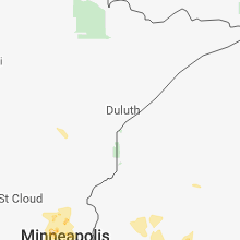
Hail Map for Monday, May 28, 2018

Number of Impacted Households on 5/28/2018
0
Impacted by 1" or Larger Hail
0
Impacted by 1.75" or Larger Hail
0
Impacted by 2.5" or Larger Hail
Square Miles of Populated Area Impacted on 5/28/2018
0
Impacted by 1" or Larger Hail
0
Impacted by 1.75" or Larger Hail
0
Impacted by 2.5" or Larger Hail


Cities Most Affected by Hail Storms of 5/28/2018
| Hail Size | Demographics of Zip Codes Affected | ||||||
|---|---|---|---|---|---|---|---|
| City | Count | Average | Largest | Pop Density | House Value | Income | Age |
| Gruver, TX | 2 | 2.75 | 2.75 | 0 | $61k | $33.2k | 36.0 |
| Mc Donald, KS | 2 | 1.75 | 1.75 | 1 | $23k | $30.6k | 52.6 |
| Atwood, KS | 2 | 1.75 | 1.75 | 4 | $49k | $32.6k | 50.7 |
| Hill City, KS | 1 | 2.50 | 2.50 | 7 | $46k | $31.3k | 48.4 |
| Fountain, CO | 1 | 2.00 | 2.00 | 421 | $118k | $42.2k | 29.0 |
| Avon, MN | 1 | 2.00 | 2.00 | 67 | $114k | $48.8k | 41.3 |
| Quinter, KS | 1 | 1.75 | 1.75 | 3 | $60k | $32.6k | 46.3 |
| Stratford, TX | 1 | 1.75 | 1.75 | 0 | $47k | $32.3k | 36.3 |
| Leoti, KS | 1 | 1.75 | 1.75 | 2 | $56k | $33.3k | 39.7 |
| Wakeeney, KS | 1 | 1.75 | 1.75 | 7 | $49k | $30.4k | 49.0 |
| Spearman, TX | 1 | 1.75 | 1.75 | 5 | $48k | $36.0k | 34.9 |
| Halliday, ND | 1 | 1.75 | 1.75 | 1 | $21k | $21.7k | 40.8 |
| Anton, CO | 1 | 1.75 | 1.75 | 1 | $65k | $35.0k | 43.8 |
| Rolla, KS | 1 | 1.75 | 1.75 | 1 | $63k | $36.5k | 37.8 |
| Flagler, CO | 1 | 1.75 | 1.75 | 1 | $74k | $30.4k | 46.7 |
| Cedar, MN | 1 | 1.75 | 1.75 | 229 | $141k | $62.3k | 39.2 |
| Goodwell, OK | 1 | 1.75 | 1.75 | 1 | $73k | $34.1k | 22.8 |
Hail and Wind Damage Spotted on 5/28/2018
Filter by Report Type:Hail ReportsWind Reports
States Impacted
Nebraska, Kansas, Indiana, Georgia, South Carolina, New York, Iowa, Illinois, Missouri, Ohio, Minnesota, Colorado, Pennsylvania, Florida, North Dakota, Kentucky, Texas, Tennessee, Oklahoma, Alabama, WisconsinNebraska
| Local Time | Report Details |
|---|---|
| 12:47 PM CDT | Penny size hail also reporte in buffalo county NE, 36.9 miles W of Grand Island, NE |
| 5:40 PM CDT | Quarter sized hail reported near Dawson, NE, 75.8 miles NNE of Manhattan, KS |
| 5:52 PM CDT | Tree branches blown down. also pea size hai in richardson county NE, 70.6 miles S of Omaha, NE |
| 6:20 PM CDT | Two end sections of a pivot blown over on the north edge of town. law enforcement estimates time was between 630-700 pm... and time was adjusted by trying to match rada in gosper county NE, 60.1 miles SE of North Platte, NE |
| 6:15 PM MDT | Ping Pong Ball sized hail reported near Benkelman, NE, 48.1 miles NNW of Colby, KS |
| 7:15 PM MDT | Ping Pong Ball sized hail reported near Benkelman, NE, 48.1 miles NNW of Colby, KS |
| 7:50 PM MDT | Pea size hail and 60 mph wind gusts reported in chase county NE, 56.8 miles ENE of Yuma, CO |
Kansas
| Local Time | Report Details |
|---|---|
| 1:00 PM CDT | Tennis Ball sized hail reported near Hill City, KS, 39.6 miles NW of Hays, KS, public reported hail 2.25 inches measured on facebook 6 miles south of hill city. |
| 1:24 PM CDT | Quarter sized hail reported near Collyer, KS, 43.3 miles WNW of Hays, KS |
| 1:31 PM CDT | Quarter sized hail reported near Bogue, KS, 38.8 miles NNW of Hays, KS |
| 1:39 PM CDT | Spotter in bogue reported measured multiple wind gusts ranging 60-70 mph. with 70 mph being the highes in graham county KS, 38.6 miles NNW of Hays, KS |
| 1:49 PM CDT | Quarter sized hail reported near Kensington, KS, 71.6 miles N of Hays, KS |
| 2:40 PM CDT | Golf Ball sized hail reported near Quinter, KS, 49.4 miles ESE of Colby, KS, em gove county reported measured golf ball hail mm 107 i-70. |
| 3:12 PM CDT | Ping Pong Ball sized hail reported near Morland, KS, 46.3 miles WNW of Hays, KS, ping pong sized hail measured by spotter. |
| 3:49 PM CDT | Ping Pong Ball sized hail reported near Quinter, KS, 49.5 miles ESE of Colby, KS, public reported via twitter hail ping pong sized in quinter. |
| 3:52 PM CDT | Quarter sized hail reported near Quinter, KS, 49.1 miles ESE of Colby, KS, spotter called in report of quarter sized hail east i-70 at quinter. |
| 3:52 PM CDT | Half Dollar sized hail reported near Collyer, KS, 44 miles WNW of Hays, KS |
| 4:01 PM CDT | Quarter sized hail reported near Quinter, KS, 49.2 miles ESE of Colby, KS, quarter sized hail reported in quinter by splinter. |
| 4:06 PM CDT | Quarter sized hail reported near Quinter, KS, 48.7 miles ESE of Colby, KS, public reported on twitter quarter sized hail in quinter. |
| 4:09 PM CDT | Quarter sized hail reported near Quinter, KS, 49.2 miles ESE of Colby, KS, spotter reported quarter sized hail falling in quinter. |
| 4:28 PM CDT | Golf Ball sized hail reported near Leoti, KS, 58.9 miles SSW of Colby, KS |
| 4:45 PM CDT | Quarter sized hail reported near Utica, KS, 53.3 miles WSW of Hays, KS |
| 4:55 PM CDT | Quarter sized hail reported near Winona, KS, 25.7 miles SSW of Colby, KS |
| 5:15 PM CDT | Quarter sized hail reported near Johnson, KS, 57 miles SW of Garden City, KS, winds also gusted to 50 mph with this storm. |
| 5:30 PM CDT | Quarter sized hail reported near Healy, KS, 36.3 miles NNE of Garden City, KS |
| 5:34 PM CDT | Quarter sized hail reported near Colby, KS, 2.6 miles S of Colby, KS |
| 5:55 PM CDT | Half Dollar sized hail reported near Scott City, KS, 35.3 miles N of Garden City, KS |
| 5:55 PM CDT | Quarter sized hail reported near Ulysses, KS, 44 miles SW of Garden City, KS |
| 5:58 PM CDT | Quarter sized hail reported near Winona, KS, 34.4 miles SSW of Colby, KS |
| 6:08 PM CDT | Quarter sized hail reported near Ulysses, KS, 37.2 miles SW of Garden City, KS |
| 6:12 PM CDT | Storm damage reported in kearny county KS, 20.3 miles WSW of Garden City, KS |
| 6:18 PM CDT | Mesonet station kuls... 1 nw ulysse in grant county KS, 37.3 miles SW of Garden City, KS |
| 6:20 PM CDT | Golf Ball sized hail reported near Rolla, KS, 62.8 miles SW of Garden City, KS |
| 6:21 PM CDT | Mesonet station c8810... 4 wnw elkhar in morton county KS, 88 miles SW of Garden City, KS |
| 6:23 PM CDT | Quarter sized hail reported near Ulysses, KS, 35.4 miles SW of Garden City, KS |
| 6:25 PM CDT | Golf Ball sized hail reported near Mc Donald, KS, 30.6 miles NNW of Colby, KS, golf ball sized hail measured by storm chaser. |
| 6:25 PM CDT | Golf Ball sized hail reported near Atwood, KS, 29.9 miles NNW of Colby, KS, golf ball hail measured by storm chaser. |
| 6:25 PM CDT | Golf Ball sized hail reported near Mc Donald, KS, 31.1 miles NNW of Colby, KS, chaser measured golf ball sized hail. |
| 6:25 PM CDT | Mesonet station k5eht... 7 wnw wilburto in morton county KS, 80.9 miles SW of Garden City, KS |
| 6:27 PM CDT | Quarter sized hail reported near Winona, KS, 25.7 miles SSW of Colby, KS |
| 6:30 PM CDT | Golf Ball sized hail reported near Atwood, KS, 29.9 miles NNW of Colby, KS |
| 6:32 PM CDT | Quarter sized hail reported near Hugoton, KS, 58.8 miles SW of Garden City, KS |
| 6:50 PM CDT | Golf Ball sized hail reported near Wakeeney, KS, 32.4 miles W of Hays, KS |
| 6:52 PM CDT | 70 mph measured with a handheld devic in phillips county KS, 55.1 miles N of Hays, KS |
| 6:58 PM CDT | Quarter sized hail reported near Scott City, KS, 34.9 miles N of Garden City, KS |
| 7:00 PM CDT | Severeal semis blown over just west of wakeene in trego county KS, 31.8 miles WNW of Hays, KS |
| 7:00 PM CDT | Public reported several semis were overturned 3 miles west of wakeeney on i-7 in trego county KS, 34.3 miles WNW of Hays, KS |
| 7:03 PM CDT | Quarter sized hail reported near Wathena, KS, 49.4 miles NNW of Kansas City, MO |
| 7:10 PM CDT | Grain bins blown off foundations and into a pil in lane county KS, 39.3 miles NNE of Garden City, KS |
| 7:22 PM CDT | Half Dollar sized hail reported near Highland, KS, 63.2 miles NW of Kansas City, MO |
| 7:22 PM CDT | Delayed report from social media. large tree down in highland. time matched to rada in doniphan county KS, 63.5 miles NW of Kansas City, MO |
| 7:25 PM CDT | Storm damage reported in thomas county KS, 17.8 miles WNW of Colby, KS |
| 7:35 PM CDT | Storm damage reported in ness county KS, 47.5 miles WSW of Hays, KS |
| 7:40 PM CDT | Public reported several semis were overturned 3 miles west of wakeeney on i-7 in trego county KS, 34.3 miles WNW of Hays, KS |
| 7:45 PM CDT | Storm damage reported in thomas county KS, 1.9 miles E of Colby, KS |
| 7:46 PM CDT | Storm damage reported in finney county KS, 35.3 miles NE of Garden City, KS |
| 7:00 PM MDT | 4" diameter tree limbs down 13 miles nnw of edso in sherman county KS, 33.6 miles WNW of Colby, KS |
| 8:01 PM CDT | Asos station gck... garden city regional airpor in finney county KS, 8.8 miles ESE of Garden City, KS |
| 8:03 PM CDT | Storm damage reported in thomas county KS, 2.3 miles N of Colby, KS |
| 8:06 PM CDT | Reported at garden city regional airpor in finney county KS, 8.8 miles ESE of Garden City, KS |
| 8:10 PM CDT | Storm damage reported in thomas county KS, 17.8 miles WNW of Colby, KS |
| 8:13 PM CDT | Semi blow over on highway 283 near the ness and hodgeman county lin in ness county KS, 52.2 miles SW of Hays, KS |
| 8:25 PM CDT | Storm damage reported in thomas county KS, 11.2 miles SSW of Colby, KS |
| 8:34 PM CDT | Law enforcement reported a semi was blown over at piercevill in finney county KS, 12.2 miles ESE of Garden City, KS |
| 8:43 PM CDT | Truck pulling camper blown off road 4 miles west of ingalls on highway 5 in gray county KS, 20.7 miles ESE of Garden City, KS |
Indiana
| Local Time | Report Details |
|---|---|
| 2:50 PM EDT | Limbs of 1 to 2 inches being snapped with some roof shingles being stripped from house in putnam county IN, 36.3 miles W of Indianapolis, IN |
| 2:51 PM EDT | Wind gust of 52 mph at brick chapel north of greencastl in putnam county IN, 38.5 miles W of Indianapolis, IN |
| 2:52 PM EDT | Road was partially blocked by downed trees. has since been cleared. time estimated based on rada in putnam county IN, 38.5 miles W of Indianapolis, IN |
| 2:52 PM EDT | Road blocked by downed trees. time estimated from rada in putnam county IN, 39 miles W of Indianapolis, IN |
| 2:55 PM EDT | Power lines knocked down by downed trees and blocking the roa in putnam county IN, 40.6 miles W of Indianapolis, IN |
| 3:00 PM EDT | Measured 59 mph gust with instrument on vehicle. on cr 350 in putnam county IN, 41.2 miles W of Indianapolis, IN |
| 5:57 PM CDT | Damage to a large bradford pear tree on the east side of evansville. winds occurred as a dry outflow boundary passed the location. at the same time... a trained spotter in vanderburgh county IN, 1.3 miles E of Evansville, IN |
| 5:57 PM CDT | Damage to a large bradford pear tree on the east side of evansville. winds occurred as a dry outflow boundary passed the location. at the same time... a trained spotter in vanderburgh county IN, 1.3 miles E of Evansville, IN |
Georgia
| Local Time | Report Details |
|---|---|
| 3:00 PM EDT | Three trees were blown on highway 135 one of which was blocking the roa in atkinson county GA, 15.6 miles SW of Douglas, GA |
| 4:06 PM EDT | 2 trees reported down by emergency manager along turner lake road. additional trees down reported along lawrence roa in upson county GA, 53.8 miles S of Atlanta, GA |
| 4:20 PM EDT | A tree was reported down on a powerline on east willow creek lan in telfair county GA, 38.3 miles N of Douglas, GA |
| 9:12 PM EDT | Power lines were reported down in the roadway on mullberry stree in jackson county GA, 60.6 miles ENE of Atlanta, GA |
| 9:18 PM EDT | Two trees reported down by emergency manager across roadway in area of tuggle rd between w. rock quarry rd and kay morgan r in gwinnett county GA, 37.2 miles NE of Atlanta, GA |
| 9:30 PM EDT | A tree was reported down along woods bridge roa in jackson county GA, 59.4 miles ENE of Atlanta, GA |
| 9:34 PM EDT | A tree and power lines were reported down in the road along pleasant acres driv in jackson county GA, 55.8 miles NE of Atlanta, GA |
| 9:34 PM EDT | A tree and power lines were reported down in the road along pleasant acres driv in jackson county GA, 55.8 miles NE of Atlanta, GA |
| 9:36 PM EDT | A tree was reported down on sims bridge roa in banks county GA, 59.4 miles SW of Greenville, SC |
| 10:15 PM EDT | Emergency manager reports one tree down across the roadway on buckhorn r in hall county GA, 54.8 miles NNE of Atlanta, GA |
South Carolina
| Local Time | Report Details |
|---|---|
| 3:10 PM EDT | Public report to the sheriff of shingles ripped off a roof. possible tornado. storm survey team will follow up tomorro in calhoun county SC, 47.8 miles WNW of Charleston, SC |
New York
| Local Time | Report Details |
|---|---|
| 3:40 PM EDT | Multiple trees dow in tompkins county NY, 41.5 miles S of Syracuse, NY |
Iowa
| Local Time | Report Details |
|---|---|
| 2:43 PM CDT | Quarter sized hail reported near Maxwell, IA, 23.8 miles NNE of Des Moines, IA, trained spotter reports quarter sized hail falling now on the south side of maxwell... along with strong winds. no damage observed. |
| 3:02 PM CDT | Quarter sized hail reported near Collins, IA, 26.1 miles NE of Des Moines, IA, report of quarter sized hail falling. |
| 3:52 PM CDT | Quarter sized hail reported near Saint Anthony, IA, 42.4 miles NNE of Des Moines, IA, trained spotter reported quarter sized hail and small branches down between saint anthony and clemons. |
| 4:48 PM CDT | Large tree branch down. via social medi in warren county IA, 9 miles SE of Des Moines, IA |
| 4:49 PM CDT | Quarter sized hail reported near Des Moines, IA, 6.1 miles SE of Des Moines, IA, mping report of quarter sized hail. |
| 4:50 PM CDT | Awos station cav... clarion airpor in wright county IA, 39.9 miles SW of Mason City, IA |
| 5:05 PM CDT | Roof removed from farm building near meservey. 4 inch tree branches down. time estimated from rada in cerro gordo county IA, 20.7 miles SW of Mason City, IA |
| 5:06 PM CDT | Large tree snapped at trunk. near davis and south union. via social media. time estimated by rada in polk county IA, 1.4 miles S of Des Moines, IA |
| 5:07 PM CDT | 10 inch diameter tree (about 12 feet tall) down along with several smaller branches. quarter hail also reported at 510 pm (sent via new lsr in hancock county IA, 25.1 miles SW of Mason City, IA |
| 5:08 PM CDT | Damage to farm building... part of roof removed. time estimated from radar. via social medi in franklin county IA, 20.1 miles SSW of Mason City, IA |
| 5:10 PM CDT | Quarter sized hail reported near Goodell, IA, 25.1 miles SW of Mason City, IA, wind damage also reported with this storm sent via lsr at 507 pm. |
| 5:22 PM CDT | Large healthy tree (about 2 feet in diameter) snapped at the base just east of garner. report via social medi in hancock county IA, 18.9 miles W of Mason City, IA |
| 5:25 PM CDT | Multiple trees down... some 1 ft plus diameter... and telephone pole damage. along highway b35 se of ventur in cerro gordo county IA, 12.8 miles WSW of Mason City, IA |
| 5:30 PM CDT | Idot rwis station along i-3 in cerro gordo county IA, 10.2 miles SW of Mason City, IA |
| 5:30 PM CDT | Several tree branches and power lines... as well as a few tree trunks... down throughout the town of clear lak in cerro gordo county IA, 8.6 miles W of Mason City, IA |
| 5:31 PM CDT | 2 inch tree limbs down. debris blowing across the road. up to nickel sized hai in hancock county IA, 17.6 miles WSW of Mason City, IA |
| 5:36 PM CDT | 60+ mph wind gusts with large trees and power lines down. report via social medi in cerro gordo county IA, 9.6 miles W of Mason City, IA |
| 5:36 PM CDT | Asos station mcw... mason city municipal airpor in cerro gordo county IA, 6.6 miles W of Mason City, IA |
| 5:38 PM CDT | Storm damage reported in cerro gordo county IA, 6.6 miles W of Mason City, IA |
| 5:43 PM CDT | Widespread tree damage. branches up to 2 to 3 inches in diamete in cerro gordo county IA, 1.6 miles N of Mason City, IA |
| 5:47 PM CDT | Numerous 3-4 inch diameter tree branches down throughout mason city. a few larger trees down as well. hail of unknown size. time estimated by rada in cerro gordo county IA, 0.2 miles NNE of Mason City, IA |
| 5:49 PM CDT | 6 inch diameter tree limbs and multiple power lines down throughout the town of clear lake. several boats on clear lake have either capsized or lost power. time estimat in cerro gordo county IA, 11.1 miles W of Mason City, IA |
| 5:56 PM CDT | Quarter sized hail reported near Mason City, IA, 1.6 miles N of Mason City, IA, hailing for 5 minutes. up to quarter sized hail driven by the wind. heavy rain. |
Illinois
| Local Time | Report Details |
|---|---|
| 3:00 PM CDT | A few healthy tree limbs blown down. a couple caused power line damag in tazewell county IL, 19.7 miles S of Peoria, IL |
| 3:55 PM CDT | Numerous tree limbs blown down on southwest side of hoopesto in vermilion county IL, 77.8 miles NNE of Mattoon, IL |
Missouri
| Local Time | Report Details |
|---|---|
| 3:20 PM CDT | Trees and power lines blown dow in lawrence county MO, 28.8 miles SW of Springfield, MO |
| 3:48 PM CDT | Quarter sized hail reported near Monett, MO, 40.5 miles WSW of Springfield, MO |
| 4:25 PM CDT | Corrects previous tstm wnd dmg report from chillicothe. multiple structures damaged within chillicothe along with multiple downed trees. time estimated from rada in livingston county MO, 73.2 miles NE of Kansas City, MO |
| 4:30 PM CDT | Quarter sized hail reported near Chillicothe, MO, 72.8 miles NE of Kansas City, MO, mostly pea sized... with some larger quarter sized stones. |
| 6:13 PM CDT | Quarter sized hail reported near Rock Port, MO, 63.1 miles SSE of Omaha, NE, time matched to radar. |
| 6:13 PM CDT | Delayed report. a few trees and power lines down. time matched to rada in atchison county MO, 62.4 miles SSE of Omaha, NE |
Ohio
| Local Time | Report Details |
|---|---|
| 4:30 PM EDT | Trees down on route 21 between routes 212 and 250 in tuscarawas county OH, 61.5 miles S of Cleveland, OH |
Minnesota
| Local Time | Report Details |
|---|---|
| 3:35 PM CDT | Quarter sized hail reported near Belle Plaine, MN, 33.2 miles SW of Minneapolis, MN, reported at church ave... and 250th... jordan... mn. |
| 3:54 PM CDT | Reported at 115 stcounty road 6... hanska... mn 30 power poles sheared off on east side or road. also small boat blown off car trailer and into the roa in brown county MN, 80.8 miles SE of Montevideo, MN |
| 4:00 PM CDT | Quarter sized hail reported near Shakopee, MN, 21.9 miles SW of Minneapolis, MN, reported at 150th and marystown rd... and shakopee... mn mostly nickel sized hail and small branches down. |
| 4:10 PM CDT | Storm damage reported in scott county MN, 19.1 miles SW of Minneapolis, MN |
| 5:00 PM CDT | Roof blown off and out buildin in mcleod county MN, 60.8 miles WSW of Minneapolis, MN |
| 5:40 PM CDT | Asos station msp... minneapolis-st. paul ap-ms in hennepin county MN, 7 miles SSE of Minneapolis, MN |
| 5:45 PM CDT | Golf Ball sized hail reported near Cedar, MN, 26.4 miles N of Minneapolis, MN |
| 5:47 PM CDT | Numerous large trees...up to 70 inch diameter down at this intersection in a unidirectional fashion. spotty power outages. reported at 125th ave ne... harper st... lino in anoka county MN, 16.6 miles NNE of Minneapolis, MN |
| 5:57 PM CDT | Numerous large trees down and intertwined in live power lines. reported at 128th and harper st... blaine... m in anoka county MN, 15.7 miles NNE of Minneapolis, MN |
| 6:39 PM CDT | Quarter sized hail reported near Milaca, MN, 52.6 miles NNW of Minneapolis, MN |
| 6:45 PM CDT | Quarter sized hail reported near Milaca, MN, 51.9 miles NNW of Minneapolis, MN |
| 7:00 PM CDT | Photo of a large tree limb down relayed via twitte in steele county MN, 49.8 miles N of Mason City, IA |
| 7:04 PM CDT | Hen Egg sized hail reported near Avon, MN, 73.9 miles NW of Minneapolis, MN |
| 9:02 PM CDT | Trees and power-lines dow in chippewa county MN, 0.2 miles SW of Montevideo, MN |
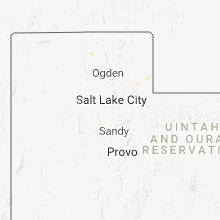
Colorado
| Local Time | Report Details |
|---|---|
| 2:46 PM MDT | Quarter sized hail reported near Evergreen, CO, 24.4 miles WSW of Denver, CO |
| 2:53 PM MDT | Quarter sized hail reported near Evergreen, CO, 20.3 miles WSW of Denver, CO |
| 2:58 PM MDT | Half Dollar sized hail reported near Evergreen, CO, 20 miles WSW of Denver, CO |
| 2:58 PM MDT | Quarter sized hail reported near Woodland Park, CO, 50.5 miles S of Denver, CO |
| 3:27 PM MDT | Quarter sized hail reported near Fountain, CO, 29.2 miles N of Pueblo, CO |
| 3:33 PM MDT | Half Dollar sized hail reported near Fountain, CO, 28.2 miles N of Pueblo, CO |
| 4:20 PM MDT | Quarter sized hail reported near Denver, CO, 8.8 miles SW of Denver, CO |
| 4:25 PM MDT | Golf Ball sized hail reported near Anton, CO, 34.4 miles SW of Yuma, CO |
| 4:29 PM MDT | Quarter sized hail reported near Denver, CO, 7.5 miles SW of Denver, CO |
| 4:36 PM MDT | Hen Egg sized hail reported near Fountain, CO, 22.2 miles N of Pueblo, CO, began at 411 and last 25 minutes. windshields and tail lights broken. roof and gutter damage. |
| 4:36 PM MDT | Quarter sized hail reported near Calhan, CO, 39.6 miles NNE of Pueblo, CO |
| 4:37 PM MDT | Quarter sized hail reported near Littleton, CO, 13.2 miles S of Denver, CO |
| 4:47 PM MDT | Golf Ball sized hail reported near Flagler, CO, 37.5 miles SSW of Yuma, CO |
| 4:56 PM MDT | Quarter sized hail reported near Englewood, CO, 12.2 miles SSE of Denver, CO |
| 5:07 PM MDT | Moved several pallets approximately 100 fee in el paso county CO, 46.3 miles NNE of Pueblo, CO |
| 5:17 PM MDT | Small tree damage and branches snapped. winds estimated at 50 mp in weld county CO, 54.4 miles NNE of Denver, CO |
| 7:15 PM MDT | Ping Pong Ball sized hail reported near Bethune, CO, 58.7 miles SSE of Yuma, CO |
| 7:16 PM MDT | Half Dollar sized hail reported near Bethune, CO, 58.6 miles SSE of Yuma, CO |
Pennsylvania
| Local Time | Report Details |
|---|---|
| 4:56 PM EDT | Trees down on worthington slatelick road in armstrong county PA, 33.8 miles NE of Pittsburgh, PA |
| 5:10 PM EDT | Trees down on ray road in armstrong county PA, 31.5 miles NNE of Pittsburgh, PA |
| 5:19 PM EDT | Trees down at johns rd and kittanning bridge in armstrong county PA, 35 miles NE of Pittsburgh, PA |
| 5:27 PM EDT | Trees down at intersection of wilson rd and hog rd in armstrong county PA, 31.2 miles NE of Pittsburgh, PA |
Florida
| Local Time | Report Details |
|---|---|
| 5:28 PM EDT | Former nws employee estimated winds near 70 mph at lake brooklyn just north of keystone heights as a severe thunderstorm passed throug in clay county FL, 42.9 miles SSW of Jacksonville, FL |
North Dakota
| Local Time | Report Details |
|---|---|
| 3:33 PM MDT | Quarter sized hail reported near New England, ND, 101.1 miles W of Bismarck, ND, most hail was pea to dime. largest stone was the size of a quarter. heavy rain measured at one inch in 20 minutes. |
| 6:10 PM MDT | Quarter sized hail reported near Taylor, ND, 85 miles WNW of Bismarck, ND, mostly nickel sized hail... with a few as large as quarters. |
| 6:24 PM MDT | Quarter sized hail reported near Halliday, ND, 83.8 miles SE of Williston, ND, also 50-60 mph winds. |
| 7:03 PM MDT | Golf Ball sized hail reported near Halliday, ND, 76.2 miles SW of Minot, ND, quarter to golf ball size hail reported. |
| 7:05 PM MDT | Half Dollar sized hail reported near Halliday, ND, 75.7 miles SW of Minot, ND, mping report from 2 miles north of halliday along highway 8. |
Kentucky
| Local Time | Report Details |
|---|---|
| 5:20 PM CDT | Large tree snapped at the bas in caldwell county KY, 59.5 miles SSW of Evansville, IN |
Texas
| Local Time | Report Details |
|---|---|
| 5:39 PM CDT | Quarter sized hail reported near Stratford, TX, 78.2 miles N of Amarillo, TX, trained spotter reported quarter sized hail. |
| 5:52 PM CDT | Half Dollar sized hail reported near Stratford, TX, 82.3 miles N of Amarillo, TX, reported via spotter network. |
| 5:53 PM CDT | Golf Ball sized hail reported near Stratford, TX, 81.9 miles N of Amarillo, TX |
| 6:08 PM CDT | Quarter sized hail reported near Spearman, TX, 75.4 miles NNE of Amarillo, TX |
| 7:16 PM CDT | Half Dollar sized hail reported near Perryton, TX, 89.2 miles W of Woodward, OK |
| 8:34 PM CDT | Baseball sized hail reported near Gruver, TX, 74.3 miles NNE of Amarillo, TX |
| 8:40 PM CDT | Baseball sized hail reported near Gruver, TX, 80.2 miles NNE of Amarillo, TX, report received via twitter. |
| 9:05 PM CDT | Golf Ball sized hail reported near Spearman, TX, 86 miles NNE of Amarillo, TX, reported on county road 1261 northeast of gruver. |
| 9:56 PM CDT | Quarter sized hail reported near Spearman, TX, 76.2 miles NNE of Amarillo, TX |
| 9:56 PM CDT | Ping Pong Ball sized hail reported near Spearman, TX, 76.6 miles NNE of Amarillo, TX, report received via spotter network. |
| 9:57 PM CDT | Quarter sized hail reported near Spearman, TX, 68.6 miles NNE of Amarillo, TX |
| 11:00 PM CDT | Ping Pong Ball sized hail reported near Perryton, TX, 81.1 miles WSW of Woodward, OK |
Tennessee
| Local Time | Report Details |
|---|---|
| 6:20 PM CDT | A few trees down on property situated on the madison/chester county line in chester county TN, 40.6 miles S of Mc Kenzie, TN |
Oklahoma
| Local Time | Report Details |
|---|---|
| 6:26 PM CDT | Quarter sized hail reported near Goodwell, OK, 95.4 miles N of Amarillo, TX, quarter size hail reported. |
| 6:44 PM CDT | Half Dollar sized hail reported near Texhoma, OK, 89.8 miles N of Amarillo, TX, quarter to half dollar size hail reported. |
| 7:05 PM CDT | Half Dollar sized hail reported near Goodwell, OK, 96 miles N of Amarillo, TX, emergency manager is reporting quarter to half dollar size hail. |
| 7:06 PM CDT | Golf Ball sized hail reported near Goodwell, OK, 96 miles N of Amarillo, TX |
| 7:32 PM CDT | Half Dollar sized hail reported near Guymon, OK, 94.3 miles SSW of Garden City, KS |
| 7:37 PM CDT | Quarter sized hail reported near Balko, OK, 86.7 miles W of Woodward, OK |
| 7:45 PM CDT | Roof blown off barn and another barn collapsed near goodwell... o in texas county OK, 96 miles N of Amarillo, TX |
| 7:57 PM CDT | Ping Pong Ball sized hail reported near Hardesty, OK, 88.8 miles W of Woodward, OK |
| 8:01 PM CDT | Ping Pong Ball sized hail reported near Hardesty, OK, 90.6 miles W of Woodward, OK |
| 8:15 PM CDT | Half Dollar sized hail reported near Guymon, OK, 94.3 miles SSW of Garden City, KS |
| 8:38 PM CDT | Roof blown off barn in texas county OK, 94.6 miles S of Garden City, KS |
| 10:04 PM CDT | Quarter sized hail reported near Balko, OK, 79.5 miles W of Woodward, OK |
| 10:12 PM CDT | Quarter sized hail reported near Balko, OK, 80.6 miles W of Woodward, OK |
| 10:47 PM CDT | Half Dollar sized hail reported near Beaver, OK, 79.3 miles WNW of Woodward, OK |
Alabama
| Local Time | Report Details |
|---|---|
| 8:10 PM CDT | Tree across road on valley street at cr 70. time estimated by rada in cherokee county AL, 63.8 miles SSW of Chattanooga, TN |
Wisconsin
| Local Time | Report Details |
|---|---|
| 10:10 PM CDT | Quarter sized hail reported near Chippewa Falls, WI, 78.1 miles N of La Crosse, WI |
Connect with Interactive Hail Maps