

Hail Map for Sunday, May 3, 2020

Number of Impacted Households on 5/3/2020
0
Impacted by 1" or Larger Hail
0
Impacted by 1.75" or Larger Hail
0
Impacted by 2.5" or Larger Hail
Square Miles of Populated Area Impacted on 5/3/2020
0
Impacted by 1" or Larger Hail
0
Impacted by 1.75" or Larger Hail
0
Impacted by 2.5" or Larger Hail


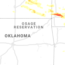


Cities Most Affected by Hail Storms of 5/3/2020
| Hail Size | Demographics of Zip Codes Affected | ||||||
|---|---|---|---|---|---|---|---|
| City | Count | Average | Largest | Pop Density | House Value | Income | Age |
| Protem, MO | 2 | 2.38 | 2.75 | 10 | $65k | $28.1k | 56.3 |
| Hollister, MO | 2 | 1.88 | 2.00 | 151 | $89k | $27.7k | 36.8 |
| Interior, SD | 1 | 2.75 | 2.75 | 1 | $81k | $29.5k | 37.8 |
| Reeds, MO | 1 | 2.75 | 2.75 | 24 | $61k | $31.4k | 39.1 |
| Branson, MO | 1 | 2.75 | 2.75 | 367 | $114k | $33.6k | 39.8 |
| Jasper, MO | 1 | 2.50 | 2.50 | 14 | $54k | $31.2k | 39.1 |
| Mountain Home, AR | 1 | 2.50 | 2.50 | 133 | $87k | $29.7k | 50.4 |
| Peel, AR | 1 | 2.00 | 2.00 | 13 | $70k | $28.8k | 53.3 |
| Norfork, AR | 1 | 2.00 | 2.00 | 21 | $83k | $29.9k | 49.8 |
| Lakeview, AR | 1 | 2.00 | 2.00 | 222 | $90k | $29.7k | 62.9 |
| Lampe, MO | 1 | 2.00 | 2.00 | 63 | $110k | $35.3k | 52.8 |
| Crane, MO | 1 | 1.75 | 1.75 | 42 | $59k | $30.0k | 40.0 |
| Yellville, AR | 1 | 1.75 | 1.75 | 16 | $70k | $26.0k | 48.3 |
| Sterling, CO | 1 | 1.75 | 1.75 | 31 | $91k | $32.2k | 37.3 |
| Midway, AR | 1 | 1.75 | 1.75 | 160 | $76k | $26.8k | 50.4 |
| Sturgis, SD | 1 | 1.75 | 1.75 | 15 | $79k | $34.9k | 44.7 |
| Oronogo, MO | 1 | 1.75 | 1.75 | 62 | $69k | $33.8k | 33.0 |
| Kimberling City, MO | 1 | 1.75 | 1.75 | 537 | $118k | $37.3k | 58.8 |
| Friendship, TN | 1 | 1.75 | 1.75 | 26 | $57k | $26.9k | 40.8 |
| Caulfield, MO | 1 | 1.75 | 1.75 | 14 | $44k | $23.1k | 46.7 |
| Webb City, MO | 1 | 1.75 | 1.75 | 441 | $72k | $30.4k | 32.4 |
| Omaha, AR | 1 | 1.75 | 1.75 | 24 | $79k | $27.2k | 44.2 |
| New Underwood, SD | 1 | 1.75 | 1.75 | 1 | $55k | $34.9k | 41.3 |
| Hammond, MT | 1 | 1.75 | 1.75 | 0 | $71k | $14.6k | 45.5 |
| Alzada, MT | 1 | 1.75 | 1.75 | 0 | $138k | $33.8k | 52.5 |
Hail and Wind Damage Spotted on 5/3/2020
Filter by Report Type:Hail ReportsWind Reports
States Impacted
Kansas, Missouri, Arkansas, Montana, Tennessee, Kentucky, South Dakota, Nebraska, Alabama, Wyoming, Georgia, North Dakota, Colorado, Virginia, DelawareKansas
| Local Time | Report Details |
|---|---|
| 7:15 AM CDT | Delayed report...power poles and several trees down along 230th street south of hamilto in greenwood county KS, 43.6 miles WNW of Chanute, KS |
| 7:15 AM CDT | Delayed report...emergency manager reports multiple trees down and wind damage to outbuildings 5 to 6 miles south of hamilton. deputy estimated the winds to have been 7 in greenwood county KS, 41.8 miles WNW of Chanute, KS |
| 7:37 AM CDT | Delayed report...many trees down west of yates center just inside the woodson county line. em also reports damage to several outbuildings and metal structures between 7 in woodson county KS, 27.3 miles WNW of Chanute, KS |
| 7:39 AM CDT | Quarter sized hail reported near Severy, KS, 48.3 miles W of Chanute, KS, delayed report received via facebook. hail ranging from dime to quarter size. time estimated based on radar. |
| 7:40 AM CDT | Corrects previous tstm wind gust (time) report from 2 wsw yates center. delayed report...measured 64mph at woodson county mesonet statio in woodson county KS, 21.8 miles NW of Chanute, KS |
| 8:05 AM CDT | Delayed report...on the west side of town there was a fairly narrow but distinct band of numerous utility poles snapped in half. time estimated based on rada in allen county KS, 17.2 miles N of Chanute, KS |
| 8:05 AM CDT | Numerous trees down in iola... including at least one tree down on a house. time estimated based on rada in allen county KS, 17.3 miles N of Chanute, KS |
| 8:10 AM CDT | First gust measured at chanute airport 810a in neosho county KS, 1 miles SSW of Chanute, KS |
| 8:15 AM CDT | Storm damage reported in montgomery county KS, 37 miles SW of Chanute, KS |
| 8:15 AM CDT | Storm damage reported in allen county KS, 17.3 miles N of Chanute, KS |
| 8:18 AM CDT | A second gust of 59mph measured at 818a in neosho county KS, 1 miles SSW of Chanute, KS |
| 8:22 AM CDT | Report of wind gusts over 60 mph at the intersection of county roads 2900 and 380 in montgomery county KS, 39.1 miles SSW of Chanute, KS |
| 8:38 AM CDT | Corrects previous tstm wnd gst (magnitude) report from coffeyville airpor in montgomery county KS, 40.7 miles S of Chanute, KS |
| 8:38 AM CDT | Corrects previous tstm wnd gst (magnitude) report from coffeyville airpor in montgomery county KS, 40.7 miles S of Chanute, KS |
| 8:40 AM CDT | Ping Pong Ball sized hail reported near Pittsburg, KS, 39 miles ESE of Chanute, KS, social media post of 1.5 inch hail damaging cars. |
| 8:43 AM CDT | A few trees down and a power pole down in coffeyvill in montgomery county KS, 45.4 miles SSW of Chanute, KS |
| 8:50 AM CDT | Thunderstorm winds resulted in over 2000 outages between elsmore... hiatville and devon... k in bourbon county KS, 29 miles ENE of Chanute, KS |
| 9:00 AM CDT | Power lines reported down due to an estimated 60 mph win in bourbon county KS, 42 miles ENE of Chanute, KS |
| 9:05 AM CDT | Quarter sized hail reported near Oswego, KS, 36.2 miles SE of Chanute, KS, dime to quarter size hail. |
| 9:15 AM CDT | Quarter sized hail reported near Pittsburg, KS, 45.1 miles ESE of Chanute, KS, report from mping: quarter (1.00 in.). |
| 9:16 AM CDT | Quarter sized hail reported near Pittsburg, KS, 46.8 miles ESE of Chanute, KS, nickel- to quarter-size hail. |
| 11:30 PM MDT | Quarter sized hail reported near Kanorado, KS, 53.4 miles W of Colby, KS, quarter size hail reported via facebook. |
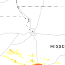
Missouri
| Local Time | Report Details |
|---|---|
| 9:03 AM CDT | Half Dollar sized hail reported near Asbury, MO, 55 miles ESE of Chanute, KS |
| 9:15 AM CDT | Tree damage reported in butler. some of the tree damage caused damage to powerlines and nearby structures. delayed report. time estimated from rada in bates county MO, 59.7 miles SSE of Kansas City, MO |
| 9:16 AM CDT | Tree down over the road near the interchange of 1400 and rebel r in vernon county MO, 58.6 miles E of Chanute, KS |
| 9:19 AM CDT | Tennis Ball sized hail reported near Jasper, MO, 62.8 miles W of Springfield, MO, 30 minutes of hail between golf ball and tennis ball size. time estimated from radar. |
| 9:20 AM CDT | Social media post of a tree snappe in vernon county MO, 54.4 miles E of Chanute, KS |
| 9:21 AM CDT | Golf Ball sized hail reported near Webb City, MO, 63.3 miles W of Springfield, MO, report from mping: golf ball (1.75 in.). |
| 9:27 AM CDT | Golf Ball sized hail reported near Oronogo, MO, 63.8 miles ESE of Chanute, KS |
| 9:28 AM CDT | Quarter sized hail reported near Carthage, MO, 62.3 miles W of Springfield, MO |
| 9:39 AM CDT | Report of power pole down due to thunderstorm winds. unable to measure wind speed in jasper county MO, 57.3 miles W of Springfield, MO |
| 9:40 AM CDT | Numerous reports of trees and powerlines down across carthag in jasper county MO, 56.2 miles W of Springfield, MO |
| 9:42 AM CDT | Tree limbs down mainly north of highway 52 in appleton city. time estimated from rada in st. clair county MO, 69.7 miles SSE of Kansas City, MO |
| 9:45 AM CDT | Half Dollar sized hail reported near Reeds, MO, 50.2 miles W of Springfield, MO, social media post of 1.5 inch hail. |
| 9:50 AM CDT | Baseball sized hail reported near Reeds, MO, 46.3 miles W of Springfield, MO, social media report of windows broken out of car. |
| 10:00 AM CDT | Mesonet station mvvm7 mt vernon raw in lawrence county MO, 35.2 miles W of Springfield, MO |
| 10:10 AM CDT | Quarter sized hail reported near Mount Vernon, MO, 30 miles WSW of Springfield, MO, quarter size hail reported via social media. |
| 10:14 AM CDT | Tree and roof damag in polk county MO, 43.5 miles NNW of Springfield, MO |
| 10:14 AM CDT | Thunderstorm winds uprooted tree in lawrence county MO, 24.5 miles SW of Springfield, MO |
| 10:14 AM CDT | Quarter sized hail reported near Mount Vernon, MO, 29.6 miles WSW of Springfield, MO |
| 10:19 AM CDT | Quarter sized hail reported near Kimberling City, MO, 40.6 miles S of Springfield, MO |
| 10:20 AM CDT | Quarter sized hail reported near Morrisville, MO, 22.7 miles NNW of Springfield, MO |
| 10:23 AM CDT | Golf Ball sized hail reported near Kimberling City, MO, 41.9 miles S of Springfield, MO, relayed via social media. |
| 10:23 AM CDT | Hen Egg sized hail reported near Lampe, MO, 44 miles S of Springfield, MO, at least hen egg sized hail in lampe. confirmed by pictures and video via social media. |
| 10:27 AM CDT | Quarter sized hail reported near Crane, MO, 26.3 miles SW of Springfield, MO |
| 10:31 AM CDT | Golf Ball sized hail reported near Crane, MO, 22.4 miles SSW of Springfield, MO |
| 10:31 AM CDT | Quarter sized hail reported near Branson, MO, 39.3 miles S of Springfield, MO, relayed from broadcast meteorologist; social media. |
| 10:35 AM CDT | Half Dollar sized hail reported near Branson, MO, 40.7 miles S of Springfield, MO, at fall creek rd and country bluff dr. photo confirmed. |
| 10:36 AM CDT | Baseball sized hail reported near Branson, MO, 42 miles S of Springfield, MO, fall creek area of branson; confirmed via social media photo. |
| 10:37 AM CDT | Relayed from amateur radi in greene county MO, 10.4 miles ENE of Springfield, MO |
| 10:38 AM CDT | Golf Ball sized hail reported near Hollister, MO, 40.7 miles S of Springfield, MO, college of the ozarks; pictures. |
| 10:39 AM CDT | Quarter sized hail reported near Hollister, MO, 40.8 miles S of Springfield, MO, relayed from law enforcement. |
| 10:39 AM CDT | Hen Egg sized hail reported near Hollister, MO, 40.1 miles S of Springfield, MO, social media post of 2 inch hail. |
| 10:41 AM CDT | Report from mping: 1-inch tree limbs broken; shingles blown of in christian county MO, 16.5 miles S of Springfield, MO |
| 10:47 AM CDT | 12 inch tree dow in webster county MO, 14.2 miles ESE of Springfield, MO |
| 10:57 AM CDT | Report from mping: 1-inch tree limbs broken; shingles blown of in vernon county MO, 59.6 miles E of Chanute, KS |
| 11:05 AM CDT | Power poles broke in lake ozark at bagnell dam blvd and flynn r in miller county MO, 55 miles SSW of Columbia, MO |
| 11:07 AM CDT | Large tree down blocking both sides of the road near highway 5 and lake freddie r in wright county MO, 41.4 miles E of Springfield, MO |
| 11:09 AM CDT | Hen Egg sized hail reported near Protem, MO, 54 miles SSE of Springfield, MO, relayed from broadcast meteorologist via social media. |
| 11:09 AM CDT | Baseball sized hail reported near Protem, MO, 54 miles SSE of Springfield, MO, corrects previous hail report from 1 ese protem. relayed from broadcast meteorologist via social media. |
| 11:45 AM CDT | Half Dollar sized hail reported near Caulfield, MO, 78.5 miles ESE of Springfield, MO |
| 11:53 AM CDT | Golf Ball sized hail reported near Caulfield, MO, 77 miles SSW of Salem, MO |
| 12:00 PM CDT | Thunderstorm winds resulted in 600 power outages in the mountain view... birch tree and winona area in shannon county MO, 44 miles S of Salem, MO |
| 12:40 PM CDT | Numerous trees down across carter county. people trapped by falling trees in a campground near van bure in carter county MO, 52.6 miles SSE of Salem, MO |
| 12:44 PM CDT | Tree limbs down. 1/4 inch hai in carter county MO, 52.6 miles SSE of Salem, MO |
| 12:45 PM CDT | 3 large trees uprooted. gust to 52mph measured with ambient weather w in ripley county MO, 65.1 miles SSE of Salem, MO |
| 12:55 PM CDT | Numerous trees down on the north side of donipha in ripley county MO, 80.5 miles SSE of Salem, MO |
| 1:07 PM CDT | Storm damage reported in ripley county MO, 78.2 miles SW of Cape Girardeau, MO |
| 1:12 PM CDT | 2 trees down in a backyard... 1 was a healthy 1 foot thick tree that snappe in butler county MO, 62.2 miles SW of Cape Girardeau, MO |
| 1:15 PM CDT | Report from mping: trees uprooted or snapped; roof blown of in wayne county MO, 55.9 miles WSW of Cape Girardeau, MO |
| 1:18 PM CDT | Live power lines down on home in neelyvill in butler county MO, 74 miles SW of Cape Girardeau, MO |
| 1:18 PM CDT | Roof completely blown off of closed business 1mi s of us67/rte14 in butler county MO, 74.9 miles SW of Cape Girardeau, MO |
| 1:18 PM CDT | Tree down on a house with residents trapped insid in butler county MO, 59.4 miles SW of Cape Girardeau, MO |
| 1:18 PM CDT | Tree down on a camper on highway 172 east of us 67. time estimate in wayne county MO, 54.9 miles WSW of Cape Girardeau, MO |
| 1:19 PM CDT | Storm damage reported in butler county MO, 56.5 miles SW of Cape Girardeau, MO |
| 1:30 PM CDT | Trees down and roof damage. radar estimated tim in butler county MO, 62.2 miles SW of Cape Girardeau, MO |
| 1:35 PM CDT | One foot diameter tree split by high wind in stoddard county MO, 46 miles SW of Cape Girardeau, MO |
| 1:39 PM CDT | Snapped trees in dexte in stoddard county MO, 42.5 miles SSW of Cape Girardeau, MO |
| 1:40 PM CDT | Branches down and shingles blown off roo in stoddard county MO, 49.6 miles SSW of Cape Girardeau, MO |
| 1:45 PM CDT | Car flipped several times by high winds. possibly tornado. time estimated by rada in stoddard county MO, 28.8 miles SW of Cape Girardeau, MO |
| 1:46 PM CDT | Trees down... pea size hai in wayne county MO, 39.1 miles WSW of Cape Girardeau, MO |
| 1:58 PM CDT | Roof damage the city hall building. homes with roof damage. several trees and power lines down. possible tornado. time estimate in new madrid county MO, 54.1 miles S of Cape Girardeau, MO |
| 2:00 PM CDT | 18 inch diameter trees snapped and blown across the road on the north side of sikeson. relayed by medi in scott county MO, 28.6 miles S of Cape Girardeau, MO |
| 2:10 PM CDT | Storm damage reported in pemiscot county MO, 64.4 miles W of Mc Kenzie, TN |
| 2:10 PM CDT | 3 miles se of holcomb roof damage and trees dow in dunklin county MO, 67.6 miles SSW of Cape Girardeau, MO |
| 2:15 PM CDT | Tree down covering cr 216 east of hwy bb. radar estimated tim in stoddard county MO, 27.9 miles SW of Cape Girardeau, MO |
| 2:20 PM CDT | Several trees down in/around east prairie. (radar time estimate in mississippi county MO, 37.2 miles SSE of Cape Girardeau, MO |
Arkansas
| Local Time | Report Details |
|---|---|
| 10:41 AM CDT | Golf Ball sized hail reported near Omaha, AR, 52.6 miles S of Springfield, MO |
| 11:24 AM CDT | Hen Egg sized hail reported near Peel, AR, 59.8 miles SSE of Springfield, MO, 2.00 inch hail in peel... ar. |
| 11:50 AM CDT | Hen Egg sized hail reported near Lakeview, AR, 70.7 miles SE of Springfield, MO, social media report of 2 inch hail. |
| 11:53 AM CDT | Ping Pong Ball sized hail reported near Mountain Home, AR, 75.4 miles SE of Springfield, MO |
| 11:54 AM CDT | Golf Ball sized hail reported near Midway, AR, 72.9 miles SE of Springfield, MO, public report of golf ball sized hail in midway. |
| 12:00 PM CDT | Quarter sized hail reported near Mountain Home, AR, 78.4 miles SE of Springfield, MO, one inch hail was reported at the baxter regional hospital. |
| 12:00 PM CDT | Ping Pong Ball sized hail reported near Mountain Home, AR, 78.4 miles SE of Springfield, MO |
| 12:08 PM CDT | Golf Ball sized hail reported near Yellville, AR, 75.3 miles SSE of Springfield, MO |
| 12:08 PM CDT | Numerous trees blown down across the western portions of the county... some blocking roads. a school building sustained minor damag in marion county AR, 75 miles SSE of Springfield, MO |
| 12:26 PM CDT | Tennis Ball sized hail reported near Mountain Home, AR, 77.9 miles SE of Springfield, MO, public report of tennis ball sized hail. |
| 12:30 PM CDT | Hen Egg sized hail reported near Norfork, AR, 90.5 miles SE of Springfield, MO |
| 12:45 PM CDT | Half Dollar sized hail reported near Calico Rock, AR, 94.8 miles N of Little Rock, AR |
| 1:02 PM CDT | Quarter sized hail reported near Melbourne, AR, 92.8 miles NNE of Little Rock, AR, social media video of quarter size hail in melbourne. |
| 1:17 PM CDT | Utility pole snapped along county road 14 in clay county AR, 84.3 miles SW of Cape Girardeau, MO |
| 1:20 PM CDT | Tree down on powerlines on sw 3rd in clay county AR, 84.5 miles SW of Cape Girardeau, MO |
| 1:20 PM CDT | Quarter sized hail reported near Sidney, AR, 93 miles NNE of Little Rock, AR, quarter size hail in sidney... ar. |
| 1:25 PM CDT | Personal weather station measured a 61 mph wind gus in lawrence county AR, 80.7 miles NW of Memphis, TN |
| 1:45 PM CDT | A few trees down in rector... clay c in clay county AR, 77.7 miles N of Memphis, TN |
| 1:50 PM CDT | 4 miles northest of jonesboro carport damage in craighead county AR, 58.7 miles NW of Memphis, TN |
| 2:00 PM CDT | Wind gust of 60mph reported by law enforcemen in craighead county AR, 67.4 miles NW of Memphis, TN |
| 2:02 PM CDT | Tree down on sage meadows golf cours in craighead county AR, 59.8 miles NNW of Memphis, TN |
| 2:10 PM CDT | Quarter sized hail reported near Lake City, AR, 51.4 miles NNW of Memphis, TN, hail to 1 inch reported by trained spotter. |
| 2:44 PM CDT | Trees damaged and powerlines down near mockingbird lane in mississippi county AR, 38.1 miles N of Memphis, TN |
| 2:49 PM CDT | Powerlines down at the intersection of hwy 18 and hwy 312 between dell and gosnell in mississippi county AR, 49 miles N of Memphis, TN |
Montana
| Local Time | Report Details |
|---|---|
| 12:00 PM MDT | Roof torn off of building. highest wind gust was 47 mph at 12pm on mt dot sensor. possible microburs in park county MT, 22.9 miles E of Bozeman, MT |
| 4:14 PM MDT | Storm damage reported in rosebud county MT, 35.4 miles NW of Miles City, MT |
| 4:23 PM MDT | Storm damage reported in rosebud county MT, 35.4 miles NW of Miles City, MT |
| 4:44 PM MDT | Storm damage reported in rosebud county MT, 35.4 miles NW of Miles City, MT |
| 5:09 PM MDT | Golf Ball sized hail reported near Hammond, MT, 87.2 miles SE of Miles City, MT, started as golf ball size and it now quarters. ground is white. |
| 5:40 PM MDT | Quarter sized hail reported near Hammond, MT, 91.6 miles SE of Miles City, MT |
| 5:50 PM MDT | Golf Ball sized hail reported near Alzada, MT, 89.3 miles NNE of Gillette, WY |
| 6:05 PM MDT | Ping Pong Ball sized hail reported near Alzada, MT, 90.4 miles NNE of Gillette, WY |
| 6:12 PM MDT | Quarter sized hail reported near Wibaux, MT, 87.1 miles SSW of Williston, ND, mostly nickel sized hail with a few pieces to the size of quarters. nearly coated the ground. |
| 6:21 PM MDT | Quarter sized hail reported near Wibaux, MT, 86.4 miles SSW of Williston, ND, nickel size with a few quarter size hail stones near the state line. |
| 7:25 PM MDT | Quarter sized hail reported near Alzada, MT, 84.3 miles NE of Gillette, WY |
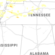
Tennessee
| Local Time | Report Details |
|---|---|
| 2:30 PM CDT | Real estate building roof blew off and onto the post office building with debris around and between buildings. the location washington ave and south 2nd. trees down and in obion county TN, 35.6 miles NW of Mc Kenzie, TN |
| 2:35 PM CDT | Several trees dow in obion county TN, 33.3 miles NW of Mc Kenzie, TN |
| 2:39 PM CDT | 2 wsw martin numerous trees down and a shed with damag in weakley county TN, 23.8 miles NW of Mc Kenzie, TN |
| 2:45 PM CDT | Multiple trees and powerlines dow in weakley county TN, 23.8 miles NW of Mc Kenzie, TN |
| 2:50 PM CDT | 5 miles n of martin tree limbs down and shingles blown off roo in weakley county TN, 23.8 miles NW of Mc Kenzie, TN |
| 2:50 PM CDT | Large tree fell very close to home on n durham ave and another large tree fell in the yard of a home on maple street. several large limbs blown off around are in weakley county TN, 18.1 miles WNW of Mc Kenzie, TN |
| 2:50 PM CDT | Tree across the road in ripley near hwy 51 in lauderdale county TN, 50.7 miles NE of Memphis, TN |
| 2:50 PM CDT | Numerous trees down across tow in weakley county TN, 15.8 miles W of Mc Kenzie, TN |
| 3:00 PM CDT | Power lines blown down and blocking roads near the nissan car dealer in tow in dyer county TN, 48.6 miles W of Mc Kenzie, TN |
| 3:05 PM CDT | Multiple trees and powerlines down in the sharon and dresden area in weakley county TN, 18.1 miles WNW of Mc Kenzie, TN |
| 3:05 PM CDT | Multiple trees and powerlines dow in weakley county TN, 23.8 miles NW of Mc Kenzie, TN |
| 3:09 PM CDT | Tree fallen on house on mt. zion in weakley county TN, 7.9 miles NW of Mc Kenzie, TN |
| 3:09 PM CDT | Trees down in mckenzie in carroll county TN, 0.7 miles NE of Mc Kenzie, TN |
| 3:10 PM CDT | Trees down at 54 and 190 near com in weakley county TN, 11.7 miles N of Mc Kenzie, TN |
| 3:14 PM CDT | 51 kt wind gust in henry county TN, 16.3 miles NNE of Mc Kenzie, TN |
| 3:15 PM CDT | Tree across the road hwy 152 and christmasville rd in gibson county TN, 26.9 miles SSW of Mc Kenzie, TN |
| 3:15 PM CDT | Four trees down at residence in three wa in madison county TN, 31.1 miles SW of Mc Kenzie, TN |
| 3:18 PM CDT | Tree onto a house on ballywood in henry county TN, 16.4 miles NE of Mc Kenzie, TN |
| 3:19 PM CDT | Several trees and powerlines down in carroll county TN, 10.5 miles SE of Mc Kenzie, TN |
| 3:20 PM CDT | 60 mph wind gust in madison county TN, 38.8 miles SSW of Mc Kenzie, TN |
| 3:20 PM CDT | Numerous trees and power poles snapped between paris and mckenzie in henry county TN, 16.4 miles NE of Mc Kenzie, TN |
| 3:25 PM CDT | Multiple trees down and power lines snapped in half along with power outages in camden area and big sandy areas. all the county has trees dow in benton county TN, 24 miles ESE of Mc Kenzie, TN |
| 3:25 PM CDT | Davis weather unit reported 62 mph wind gust at 323 p in benton county TN, 24.9 miles ENE of Mc Kenzie, TN |
| 3:25 PM CDT | Power lines down and pole onto house on lankford lan in carroll county TN, 16.7 miles ESE of Mc Kenzie, TN |
| 3:26 PM CDT | Large tree down by brownsville pd in haywood county TN, 54.4 miles NE of Memphis, TN |
| 3:27 PM CDT | Multiple trees dow in carroll county TN, 0.7 miles NE of Mc Kenzie, TN |
| 3:37 PM CDT | Numerous trees and power poles snapped between paris and mckenzie in henry county TN, 16.4 miles NE of Mc Kenzie, TN |
| 3:38 PM CDT | Trees down on highway 232 in stewart county TN, 37.6 miles NE of Mc Kenzie, TN |
| 3:39 PM CDT | Large tree on power lines in carroll county TN, 15.4 miles ESE of Mc Kenzie, TN |
| 3:41 PM CDT | Multiple trees dow in carroll county TN, 22 miles SSW of Mc Kenzie, TN |
| 3:43 PM CDT | Power lines down and pole onto house on lankford lan in carroll county TN, 16.7 miles ESE of Mc Kenzie, TN |
| 3:43 PM CDT | Storm damage reported in stewart county TN, 44.9 miles ENE of Mc Kenzie, TN |
| 3:45 PM CDT | Tree down over the road on hwy 22 near edge road... eastside of chester c in chester county TN, 45 miles S of Mc Kenzie, TN |
| 3:45 PM CDT | Numerous trees down and power outages across houston county in houston county TN, 47.6 miles ENE of Mc Kenzie, TN |
| 3:49 PM CDT | Several trees down and outbuildings damaged around mcewen in humphreys county TN, 48.4 miles W of Nashville, TN |
| 3:51 PM CDT | Tree on a house on twin oaks road. numerous trees down across western stewart county with appx 1000 people without power in stewart county TN, 41.6 miles NE of Mc Kenzie, TN |
| 4:00 PM CDT | Numerous trees down and power outages throughout dickson county including on hummingbird lane. tree on house at walnut grove road at yellow creek road in dickson county TN, 34.2 miles W of Nashville, TN |
| 4:05 PM CDT | Numerous reports of trees and power lines down with power outages across perry county in perry county TN, 52.5 miles SE of Mc Kenzie, TN |
| 4:08 PM CDT | Several trees down on pinewood road...oak springs road...and highway 100 in hickman county TN, 36.3 miles WSW of Nashville, TN |
| 4:10 PM CDT | Trees down on barker driv in hardin county TN, 43.2 miles NW of Florence, AL |
| 4:10 PM CDT | Roofs blown off several buildings and numerous trees down in hohenwald in lewis county TN, 52.1 miles N of Florence, AL |
| 4:15 PM CDT | Trees down across waynesboro including at the golf course in wayne county TN, 36.1 miles N of Florence, AL |
| 4:15 PM CDT | Trees uprooted and power lines down on walnut grove road in dickson county TN, 38.8 miles W of Nashville, TN |
| 4:18 PM CDT | Several trees down around clarksville in montgomery county TN, 41.8 miles NW of Nashville, TN |
| 4:19 PM CDT | Tree limbs down and power outages in cheatham county TN, 17.5 miles WNW of Nashville, TN |
| 4:27 PM CDT | Numerous trees down on the natchez trace parkway blocking the road in wayne county TN, 26.4 miles N of Florence, AL |
| 4:30 PM CDT | Trees down in columbia...power out across much of the count in maury county TN, 40.7 miles SSW of Nashville, TN |
| 4:30 PM CDT | Trees down in backyard of nws employee house in williamson county TN, 16.8 miles SSW of Nashville, TN |
| 4:30 PM CDT | Numerous trees down and roof damage to homes in spring hill in maury county TN, 30.5 miles SSW of Nashville, TN |
| 4:35 PM CDT | Numerous trees and power lines down across nashville. over 130000 customers without powe in davidson county TN, 0.2 miles NNW of Nashville, TN |
| 4:35 PM CDT | Multiple large trees down 1 mile north of concord rd and wilson pike intersection. 1 tree fell on a dog kennel...no dogs in the kennel at the tim in williamson county TN, 11.6 miles S of Nashville, TN |
| 4:35 PM CDT | Historic 200 year old oak tree blown down at jt moore middle school in davidson county TN, 5.5 miles SSW of Nashville, TN |
| 4:35 PM CDT | *** 1 fatal *** tree reportedly fell onto and killed a man near bethesda road at highway 431 in williamson county TN, 26.3 miles S of Nashville, TN |
| 4:40 PM CDT | Tree down in yard of home of nws employee in davidson county TN, 2.7 miles NE of Nashville, TN |
| 4:40 PM CDT | Numerous trees and power lines down across the northern half of henderson count in henderson county TN, 34.1 miles SSE of Mc Kenzie, TN |
| 4:41 PM CDT | Large tree fell on a house on mockingbird lan in maury county TN, 40.7 miles SSW of Nashville, TN |
| 4:42 PM CDT | Brick garage wall collapsed in gum springs... tn in lawrence county TN, 34.6 miles NE of Florence, AL |
| 4:44 PM CDT | Nashville airport asos measured a wind gust of 62 knots / 71 mph in davidson county TN, 6.4 miles ESE of Nashville, TN |
| 4:44 PM CDT | Four corners marina was damaged as well as several boats in davidson county TN, 9.7 miles ESE of Nashville, TN |
| 4:45 PM CDT | On highway 412 a carport was blown into power line in henderson county TN, 34.1 miles SSE of Mc Kenzie, TN |
| 4:46 PM CDT | *** 1 inj *** falling tree injured hiker near percy priest lake in davidson county TN, 13.8 miles SE of Nashville, TN |
| 4:47 PM CDT | Storm damage reported in davidson county TN, 0.2 miles NNW of Nashville, TN |
| 4:48 PM CDT | Tree on house in the bonnas neighborhood in hermitage in davidson county TN, 8.8 miles ENE of Nashville, TN |
| 4:49 PM CDT | Trees and power lines down throughout lincoln county power is out in about 1/2 of the county. the gust front entered northwest lincoln county around 449 pm and exiting in lincoln county TN, 57.1 miles ENE of Florence, AL |
| 4:50 PM CDT | Tree down on home of nws employee. numerous trees down in neighborhood in wilson county TN, 14.5 miles E of Nashville, TN |
| 4:50 PM CDT | Tree fell onto home on brookstone blvd in mount juliet causing major damage in wilson county TN, 14.1 miles E of Nashville, TN |
| 4:51 PM CDT | Tree fell onto a car on shute lane near brandywine in davidson county TN, 10.3 miles ENE of Nashville, TN |
| 4:51 PM CDT | Smyrna airport asos measured a wind gust of 53 knots / 61 mph in rutherford county TN, 19 miles SE of Nashville, TN |
| 4:54 PM CDT | Numerous trees down across mount juliet. barn collapsed at 8485 lebanon roa in wilson county TN, 17.8 miles ENE of Nashville, TN |
| 4:55 PM CDT | Large trees down...wind gust estimation of 70 mph in rutherford county TN, 16.4 miles SE of Nashville, TN |
| 4:58 PM CDT | Numerous trees down in gallatin in sumner county TN, 23.5 miles NE of Nashville, TN |
| 5:00 PM CDT | Widespread wind damage....trees down and a barn damage in lawrence county TN, 36.4 miles NNE of Florence, AL |
| 5:00 PM CDT | Widespread wind damage....trees down and a barn damage in lawrence county TN, 36.4 miles NNE of Florence, AL |
| 5:02 PM CDT | Roof blown off title max store on madison street in bedford county TN, 50.2 miles SSE of Nashville, TN |
| 5:04 PM CDT | Trees dow in wilson county TN, 25.9 miles E of Nashville, TN |
| 5:05 PM CDT | Trees and power lines down across the county. one tree is down on a house. the gust front entered northwest moore county at 505 pm cdt and exited around 523 pm cdt in t in lincoln county TN, 58.8 miles SSE of Nashville, TN |
| 5:10 PM CDT | A large tree was uprooted and knocked down. report via social medi in lincoln county TN, 68.3 miles W of Chattanooga, TN |
| 5:13 PM CDT | Numerous trees down and barn roofs blown off in the flat rock road at highway 70 area in smith county TN, 38.3 miles E of Nashville, TN |
| 5:17 PM CDT | Numerous trees down on lock 7 lane in smith county TN, 43 miles E of Nashville, TN |
| 5:17 PM CDT | *** 2 inj *** numerous trees down with power outages across cannon county. tree fell onto an atv injuring 2 peopl in cannon county TN, 46.4 miles ESE of Nashville, TN |
| 5:17 PM CDT | Multiple trees down in tullahoma in coffee county TN, 56.1 miles WNW of Chattanooga, TN |
| 5:18 PM CDT | Widespread trees and power outages reported in the county. the most widespread damage was in northern franklin county. roof damage reported at a residence on highway 12 in franklin county TN, 56.5 miles WNW of Chattanooga, TN |
| 5:18 PM CDT | Several trees down and buildings damaged in dixon springs in smith county TN, 42.8 miles ENE of Nashville, TN |
| 5:20 PM CDT | Barn destroyed in the hackett subdivision in tanglewood in smith county TN, 44.7 miles E of Nashville, TN |
| 5:25 PM CDT | Destroyed shed on dog branch road in smith county TN, 51.4 miles ENE of Nashville, TN |
| 5:32 PM CDT | Estimated gusts of 60 mph... lawn furniture displaced and damaged... and small tree limbs broke in lincoln county TN, 56.1 miles ENE of Florence, AL |
| 5:35 PM CDT | Mcminnville awos measured a wind gust of 52 knots / 60 mph in warren county TN, 54.1 miles NNW of Chattanooga, TN |
| 5:40 PM CDT | Trees blown down in front of the courthouse in grundy county TN, 35.6 miles NW of Chattanooga, TN |
| 5:45 PM CDT | Multiple trees down near monteagle in grundy county TN, 32.9 miles WNW of Chattanooga, TN |
| 5:50 PM CDT | Multiple reports of trees down across putnam county with power outages in putnam county TN, 70.9 miles E of Nashville, TN |
| 5:50 PM CDT | Quarter sized hail reported near Jackson, TN, 40.7 miles SSW of Mc Kenzie, TN, quarter sized hail on perry switch road. started as pea sized hail. |
| 5:50 PM CDT | Half Dollar sized hail reported near Trenton, TN, 28.6 miles WSW of Mc Kenzie, TN, half dollar sized hail along the gibson and crockett county border. |
| 5:55 PM CDT | Trees down blocking greenbriar road and hilham highway at standing stone highway. power lines down on carmack stree in overton county TN, 82.3 miles E of Nashville, TN |
| 5:55 PM CDT | Half Dollar sized hail reported near Dyersburg, TN, 46.7 miles W of Mc Kenzie, TN, half dollar and quarter sized hail in bonicord. |
| 6:00 PM CDT | Golf Ball sized hail reported near Friendship, TN, 43.2 miles WSW of Mc Kenzie, TN, tigrett grocery reported large hail some up to golf ball size. |
| 6:04 PM CDT | Multiple trees down in the count in sequatchie county TN, 23.7 miles NNW of Chattanooga, TN |
| 6:11 PM CDT | Multiple trees down across northern marion count in marion county TN, 22.5 miles NW of Chattanooga, TN |
| 6:15 PM CDT | Tree on a house on vandever road near highway 127 s and tree on a house on old peavine road in cumberland county TN, 62.7 miles W of Knoxville, TN |
| 6:20 PM CDT | Tree on house on vandever road close to hwy 127 south in cumberland county TN, 55.4 miles NNE of Chattanooga, TN |
| 6:24 PM CDT | Tree on house on old peavine road in crossville in cumberland county TN, 58.8 miles W of Knoxville, TN |
| 7:25 PM EDT | Powerlines down on crabtree r in hamilton county TN, 12.9 miles NE of Chattanooga, TN |
| 7:25 PM EDT | Trees and powerlines down on dayton mountain hw in rhea county TN, 36.8 miles NNE of Chattanooga, TN |
| 7:28 PM EDT | Tree down on boston lan in hamilton county TN, 11.7 miles NNE of Chattanooga, TN |
| 6:30 PM CDT | Ping Pong Ball sized hail reported near Jackson, TN, 37 miles SSW of Mc Kenzie, TN, large hail up to ping pong size in oakfield. |
| 7:34 PM EDT | Large tree uproote in rhea county TN, 51.1 miles NNE of Chattanooga, TN |
| 7:40 PM EDT | 1 tree down on nashville highway in the lancing are in morgan county TN, 48.2 miles WNW of Knoxville, TN |
| 7:40 PM EDT | Large tree down on hwy 1 in bradley county TN, 32.9 miles ENE of Chattanooga, TN |
| 7:40 PM EDT | Multiple trees down across the count in rhea county TN, 45.9 miles NNE of Chattanooga, TN |
| 6:48 PM CDT | Tree down on home of nws employee. numerous trees down in neighborhood in wilson county TN, 14.5 miles E of Nashville, TN |
Kentucky
| Local Time | Report Details |
|---|---|
| 2:33 PM CDT | Larger limbs and small trees down west of clinton. radar estimated tim in hickman county KY, 46 miles NW of Mc Kenzie, TN |
| 2:34 PM CDT | Several large tree limb dow in fulton county KY, 36.2 miles NW of Mc Kenzie, TN |
| 2:39 PM CDT | Trees down in fulton. radar estimated tim in fulton county KY, 33.4 miles NW of Mc Kenzie, TN |
| 2:40 PM CDT | Tree down over i-69 south. radar estimated tim in hickman county KY, 33 miles NNW of Mc Kenzie, TN |
| 2:45 PM CDT | Trees and power lines down just south of graves. time estimate in graves county KY, 37.1 miles NNW of Mc Kenzie, TN |
| 2:48 PM CDT | Report from mping: trees uprooted or snapped; roof blown off (radar estimated time in graves county KY, 36.9 miles NNW of Mc Kenzie, TN |
| 2:50 PM CDT | Ky mesonet observatio in graves county KY, 39.3 miles NNW of Mc Kenzie, TN |
| 2:51 PM CDT | Numerous trees down including a tree on a home and on a suv. several power lines down in the area. occurred near dukedom 1 mile north of the tennessee borde in graves county KY, 28.3 miles NNW of Mc Kenzie, TN |
| 2:51 PM CDT | Report from mping: 3-inch tree limbs broken; power poles broken (radar estimated time in graves county KY, 40 miles NNW of Mc Kenzie, TN |
| 2:52 PM CDT | Report from mping: trees uprooted or snapped; roof blown off. (radar estimated time in graves county KY, 39.9 miles NNW of Mc Kenzie, TN |
| 3:10 PM CDT | A couple trees uproote in calloway county KY, 34.7 miles NNE of Mc Kenzie, TN |
| 3:10 PM CDT | Roof peeled back from a horse bar in calloway county KY, 32.6 miles NNE of Mc Kenzie, TN |
| 3:12 PM CDT | Tree on residence. radar estimated tim in calloway county KY, 30.2 miles N of Mc Kenzie, TN |
| 3:18 PM CDT | Trees down at ky 94 and robertson road. trees also down at ky 464 and ky 183 in calloway county KY, 34.2 miles NNE of Mc Kenzie, TN |
| 3:20 PM CDT | Dispatch reports tree on power line causing a fire. brooks chapel rd 1/2 mile n of ky464. radar estimated tim in calloway county KY, 40.9 miles NNE of Mc Kenzie, TN |
| 6:13 PM EDT | Large tree limbs down reported via social media with pictur in montgomery county KY, 24.9 miles N of Irvine, KY |
| 6:15 PM EDT | Reports of multiple tree and limbs down and utility lines down in and near mount sterlin in montgomery county KY, 24.9 miles N of Irvine, KY |
| 6:19 PM EDT | The top of a 10 inch diameter cherry tree was snappe in montgomery county KY, 23 miles NNE of Irvine, KY |
| 6:42 PM EDT | Car struck tree over irvine rd. near intersection with snow creek rd. no fatalitie in powell county KY, 11.1 miles N of Irvine, KY |
| 6:52 PM EDT | Corrects previous tstm wnd dmg report from powell valley. car struck tree that had been downed over irvine rd. near intersection with snow creek rd. no fatalitie in powell county KY, 11.1 miles N of Irvine, KY |
| 7:14 PM EDT | Powerlines were reported to have been blown down at a residenc in wolfe county KY, 20.6 miles ENE of Irvine, KY |
| 7:17 PM EDT | 3 trees were reported down onto us 46 in morgan county KY, 44.2 miles ENE of Irvine, KY |
| 7:55 PM EDT | A tree was blown down onto powerlines knocking all traffic lights out in the cit in johnson county KY, 64.2 miles E of Irvine, KY |
| 8:05 PM EDT | Tree blown onto a powerline knocking the powerline into the road on ky 58 in jackson county KY, 19.4 miles S of Irvine, KY |
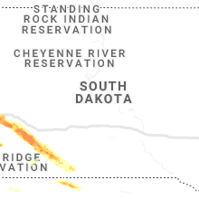
South Dakota
| Local Time | Report Details |
|---|---|
| 2:50 PM MDT | Half Dollar sized hail reported near Sturgis, SD, 30.5 miles NW of Rapid City, SD |
| 3:10 PM MDT | Quarter sized hail reported near Black Hawk, SD, 8.7 miles NW of Rapid City, SD, mostly peas... but lots of it |
| 3:18 PM MDT | Quarter sized hail reported near Black Hawk, SD, 8.7 miles NW of Rapid City, SD, mostly pea to marble size hail. a few up to quarter size |
| 3:20 PM MDT | Quarter sized hail reported near Sturgis, SD, 26.6 miles NNW of Rapid City, SD |
| 3:31 PM MDT | Quarter sized hail reported near Sturgis, SD, 26.6 miles NNW of Rapid City, SD |
| 3:36 PM MDT | Golf Ball sized hail reported near Sturgis, SD, 26.6 miles NNW of Rapid City, SD |
| 3:38 PM MDT | Quarter sized hail reported near Black Hawk, SD, 6.5 miles NW of Rapid City, SD |
| 3:54 PM MDT | Quarter sized hail reported near Rapid City, SD, 4.8 miles N of Rapid City, SD |
| 4:00 PM MDT | Quarter sized hail reported near Rapid City, SD, 3.4 miles N of Rapid City, SD |
| 4:00 PM MDT | Half Dollar sized hail reported near Rapid City, SD, 4.8 miles N of Rapid City, SD |
| 4:02 PM MDT | Ping Pong Ball sized hail reported near Rapid City, SD, 4.8 miles N of Rapid City, SD |
| 4:06 PM MDT | Ping Pong Ball sized hail reported near Rapid City, SD, 3.4 miles N of Rapid City, SD, up to ping pong ball size hail |
| 4:07 PM MDT | Ping Pong Ball sized hail reported near Rapid City, SD, 2.7 miles N of Rapid City, SD, north haines fire department |
| 4:25 PM MDT | Ping Pong Ball sized hail reported near Rapid City, SD, 5.1 miles E of Rapid City, SD |
| 5:00 PM MDT | Quarter sized hail reported near Rapid City, SD, 2.4 miles SSE of Rapid City, SD |
| 5:02 PM MDT | Golf Ball sized hail reported near New Underwood, SD, 20.7 miles ESE of Rapid City, SD |
| 6:00 PM MDT | Quarter sized hail reported near Scenic, SD, 41.3 miles ESE of Rapid City, SD |
| 6:32 PM MDT | Quarter sized hail reported near Hill City, SD, 22.7 miles SW of Rapid City, SD |
| 6:40 PM MDT | Quarter sized hail reported near Scenic, SD, 60.6 miles ESE of Rapid City, SD, ground covered with dime to quarter size hail |
| 7:05 PM MDT | Baseball sized hail reported near Interior, SD, 72.1 miles ESE of Rapid City, SD |
| 7:34 PM MDT | Half Dollar sized hail reported near Wanblee, SD, 77.3 miles NW of Valentine, NE |
| 7:53 PM MDT | Half Dollar sized hail reported near Long Valley, SD, 66.3 miles NW of Valentine, NE, over an inch of rain |
| 8:13 PM MDT | Quarter sized hail reported near Martin, SD, 59.4 miles NW of Valentine, NE, ground is white |
Nebraska
| Local Time | Report Details |
|---|---|
| 3:58 PM MDT | Half Dollar sized hail reported near Grant, NE, 57.9 miles WSW of North Platte, NE |
| 4:10 PM MDT | Quarter sized hail reported near Lewellen, NE, 72.2 miles WNW of North Platte, NE, hail up to quarter size. ground covered |
| 5:00 PM MDT | Ping Pong Ball sized hail reported near Elsie, NE, 41.4 miles SW of North Platte, NE |
| 6:50 PM CDT | Estimated 60 mph wind gust. observer said it knocked over a wind break which is supposed to sustain 50 to 60 mph winds. small hail as wel in hayes county NE, 44.8 miles SSW of North Platte, NE |
| 6:46 PM MDT | Quarter sized hail reported near Big Springs, NE, 65.7 miles W of North Platte, NE, a lot of small hail with one or two quarter-size stones. time estimated from radar. |
| 7:26 PM MDT | Quarter sized hail reported near Ogallala, NE, 47.6 miles W of North Platte, NE |
Alabama
| Local Time | Report Details |
|---|---|
| 5:00 PM CDT | Thunderstorm winds knocked down trees at cr 136 at highway 6 in lauderdale county AL, 20.9 miles NE of Florence, AL |
| 5:00 PM CDT | Thunderstorm winds knocked down trees on cr 6 near the double bridge in lauderdale county AL, 8.4 miles NW of Florence, AL |
| 5:00 PM CDT | Thunderstorms winds knocked trees down at cr 34 and cr 7 in lauderdale county AL, 12.2 miles NNE of Florence, AL |
| 5:00 PM CDT | A small shed was destroyed on cr 36 at travis drive in kille in lauderdale county AL, 12.9 miles NE of Florence, AL |
| 5:01 PM CDT | Report from mping: 1-inch tree limbs broken; shingles blown of in lauderdale county AL, 3.4 miles N of Florence, AL |
| 5:10 PM CDT | Trees down on compton street in elkmon in limestone county AL, 40.7 miles ENE of Florence, AL |
| 5:15 PM CDT | Trees and powerlines were knocked down throughout limestone county. power outages reported in elk river... tanner... athens and elkmon in limestone county AL, 40.1 miles E of Florence, AL |
| 5:15 PM CDT | A large tree was uprooted and knocked over onto power lines. video relayed via social medi in madison county AL, 55.9 miles ENE of Florence, AL |
| 5:16 PM CDT | Trees down on cook roa in madison county AL, 52.2 miles E of Florence, AL |
| 5:16 PM CDT | Trees down on cook roa in madison county AL, 52.2 miles E of Florence, AL |
| 5:16 PM CDT | Report from mping: 1-inch tree limbs broken; shingles blown of in limestone county AL, 50.1 miles ENE of Florence, AL |
| 5:20 PM CDT | Multiple large tall trees uprooted and knocked down on roy davis road and joe quick roa in madison county AL, 66.9 miles E of Florence, AL |
| 5:21 PM CDT | Report from mping: trees uprooted or snapped; roof blown of in limestone county AL, 50.2 miles E of Florence, AL |
| 5:25 PM CDT | Mckee rd between hwy 53 & jeff rd is closed until further notice due to trees... utility pole and lines across the roadwa in madison county AL, 54 miles E of Florence, AL |
| 5:25 PM CDT | A bradford pear tree snapped on pettus at hillgate roa in madison county AL, 53.8 miles E of Florence, AL |
| 5:25 PM CDT | Large tree branch down at indian creek and plummer roa in madison county AL, 56.1 miles E of Florence, AL |
| 5:26 PM CDT | Damage to a barn. time estimated by rada in madison county AL, 62.6 miles E of Florence, AL |
| 5:29 PM CDT | Trees downed. time estimated from rada in madison county AL, 66.3 miles E of Florence, AL |
| 5:30 PM CDT | Tree down on a fence in bellglade subdivision. relayed on social medi in madison county AL, 67.9 miles WSW of Chattanooga, TN |
| 5:30 PM CDT | Trees downed. time estimated from rada in madison county AL, 68 miles E of Florence, AL |
| 5:30 PM CDT | Aprs station ew640 in madison county AL, 67.7 miles W of Chattanooga, TN |
| 5:31 PM CDT | Tree down on old madison pike at sherwood baptist church. relayed via social medi in madison county AL, 57.5 miles E of Florence, AL |
| 5:31 PM CDT | Report from mping: trees uprooted or snapped; roof blown of in madison county AL, 67.5 miles W of Chattanooga, TN |
| 5:32 PM CDT | Trees down and power transformer on bob wallace roa in madison county AL, 60.4 miles E of Florence, AL |
| 5:33 PM CDT | Social media report of a window blown out of their home in the five points neigbhorhoo in madison county AL, 62.4 miles E of Florence, AL |
| 5:33 PM CDT | A tree down on sullivan at front street in madiso in madison county AL, 53.2 miles E of Florence, AL |
| 5:35 PM CDT | Thunderstorm wind damage at the bob jones high school softball field and dugou in madison county AL, 52.9 miles E of Florence, AL |
| 5:35 PM CDT | Report from mping: 1-inch tree limbs broken; shingles blown of in madison county AL, 61 miles E of Florence, AL |
| 5:36 PM CDT | A tree down on lime quarry road. relayed via social medi in madison county AL, 53.9 miles E of Florence, AL |
| 5:44 PM CDT | Report from mping: 1-inch tree limbs broken; shingles blown of in madison county AL, 66.1 miles E of Florence, AL |
| 5:51 PM CDT | Report from mping: trees uprooted or snapped; roof blown of in madison county AL, 67.3 miles E of Florence, AL |
| 5:58 PM CDT | Report from mping: 1-inch tree limbs broken; shingles blown of in madison county AL, 61.9 miles E of Florence, AL |
| 6:04 PM CDT | Report from mping: 3-inch tree limbs broken; power poles broke in madison county AL, 71.3 miles ESE of Florence, AL |
| 6:06 PM CDT | Report from mping: trees uprooted or snapped; roof blown of in madison county AL, 68 miles E of Florence, AL |
| 6:30 PM CDT | A large tree was down and large tree limbs dow in jackson county AL, 50.7 miles SW of Chattanooga, TN |
| 6:30 PM CDT | A tin porch roof was blown off of a house and lofted about 20 feet into a tree at the intersection of davistown road and mountaindale circl in jackson county AL, 51.2 miles SW of Chattanooga, TN |
Wyoming
| Local Time | Report Details |
|---|---|
| 4:04 PM MDT | Quarter sized hail reported near Upton, WY, 45.7 miles ESE of Gillette, WY |
Georgia
| Local Time | Report Details |
|---|---|
| 7:16 PM EDT | Tree reported down near the intersection of hwy 11 north and wawona d in dade county GA, 8.2 miles SW of Chattanooga, TN |
| 7:16 PM EDT | Tree reported down near the intersection of hwy 301 north and wells r in dade county GA, 17 miles SW of Chattanooga, TN |
| 7:19 PM EDT | Tree reported down on burkhalter gap rd near scenic view l in dade county GA, 13.8 miles SW of Chattanooga, TN |
| 7:20 PM EDT | Tree reported down near the intersection of scenic hwy and fox trail r in dade county GA, 13.4 miles SW of Chattanooga, TN |
North Dakota
| Local Time | Report Details |
|---|---|
| 6:26 PM MDT | Quarter sized hail reported near Beach, ND, 86.7 miles SSW of Williston, ND, multiple reports by trained spotters of one inch hail in the town of beach between 726 and 732 pm cdt. |
Colorado
| Local Time | Report Details |
|---|---|
| 7:34 PM MDT | Quarter sized hail reported near Matheson, CO, 72.4 miles ESE of Denver, CO |
| 8:30 PM MDT | Quarter sized hail reported near Otis, CO, 13.4 miles NW of Yuma, CO |
| 9:46 PM MDT | Quarter sized hail reported near Limon, CO, 69.1 miles ESE of Denver, CO |
| 10:38 PM MDT | Quarter sized hail reported near Merino, CO, 54.4 miles NW of Yuma, CO |
| 10:55 PM MDT | Golf Ball sized hail reported near Sterling, CO, 43.7 miles NW of Yuma, CO |
Virginia
| Local Time | Report Details |
|---|---|
| 11:20 PM EDT | Large tree branches down near the intersection of caledon road and dahlgren roa in king george county VA, 63.7 miles NNE of Richmond, VA |
| 11:23 PM EDT | Large tree branches down near the intersection of james madison parkway and poplar neck roa in king george county VA, 61.5 miles NNE of Richmond, VA |
| 11:25 PM EDT | Large tree branches down near the intersection of ridge road and shiloh driv in king george county VA, 61.1 miles NNE of Richmond, VA |
Delaware
| Local Time | Report Details |
|---|---|
| 12:04 AM EDT | Wxflow senso in sussex county DE, 23.8 miles N of Ocean City, MD |
| 12:05 AM EDT | Power lines down near conquest road. time estimated from rada in sussex county DE, 21.7 miles N of Ocean City, MD |
Connect with Interactive Hail Maps