

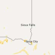
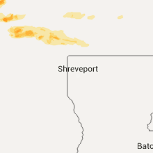
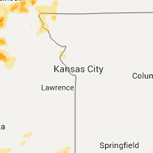
Hail Map for Monday, May 9, 2016

Number of Impacted Households on 5/9/2016
0
Impacted by 1" or Larger Hail
0
Impacted by 1.75" or Larger Hail
0
Impacted by 2.5" or Larger Hail
Square Miles of Populated Area Impacted on 5/9/2016
0
Impacted by 1" or Larger Hail
0
Impacted by 1.75" or Larger Hail
0
Impacted by 2.5" or Larger Hail


Cities Most Affected by Hail Storms of 5/9/2016
| Hail Size | Demographics of Zip Codes Affected | ||||||
|---|---|---|---|---|---|---|---|
| City | Count | Average | Largest | Pop Density | House Value | Income | Age |
| Lincoln, NE | 3 | 2.92 | 4.25 | 5051 | $74k | $26.8k | 26.7 |
| Coalgate, OK | 3 | 2.92 | 4.00 | 10 | $36k | $23.6k | 41.6 |
| Sharon, KS | 4 | 2.00 | 2.50 | 3 | $29k | $31.7k | 43.8 |
| Tryon, NE | 3 | 1.83 | 2.00 | 0 | $42k | $25.2k | 42.8 |
| Durant, OK | 2 | 2.13 | 2.50 | 126 | $66k | $28.2k | 33.5 |
| Blackwell, OK | 2 | 1.88 | 2.00 | 83 | $37k | $26.3k | 39.4 |
| Lyons, KS | 2 | 1.75 | 1.75 | 23 | $46k | $35.8k | 40.0 |
| Clarksville, TX | 2 | 1.75 | 1.75 | 17 | $33k | $25.5k | 46.2 |
| Bokchito, OK | 1 | 3.00 | 3.00 | 10 | $37k | $25.9k | 40.8 |
| Minneapolis, KS | 1 | 2.75 | 2.75 | 11 | $64k | $35.5k | 41.7 |
| Washington, KS | 1 | 2.75 | 2.75 | 13 | $40k | $30.9k | 47.3 |
| Sumner, TX | 1 | 2.75 | 2.75 | 25 | $61k | $37.6k | 39.4 |
| Stapleton, NE | 1 | 2.75 | 2.75 | 1 | $53k | $33.9k | 45.0 |
| Linn, KS | 1 | 2.75 | 2.75 | 6 | $38k | $28.9k | 45.5 |
| Greenleaf, KS | 1 | 2.50 | 2.50 | 3 | $19k | $26.3k | 47.8 |
| Medicine Lodge, KS | 1 | 2.50 | 2.50 | 8 | $40k | $34.5k | 42.6 |
| Belleville, KS | 1 | 2.00 | 2.00 | 16 | $46k | $30.2k | 51.0 |
| Randolph, KS | 1 | 2.00 | 2.00 | 4 | $67k | $38.0k | 45.6 |
| Newalla, OK | 1 | 1.75 | 1.75 | 152 | $88k | $42.8k | 41.1 |
| Strang, NE | 1 | 1.75 | 1.75 | 3 | $37k | $38.8k | 44.3 |
| Wynnewood, OK | 1 | 1.75 | 1.75 | 28 | $46k | $29.1k | 41.6 |
| Caldwell, KS | 1 | 1.75 | 1.75 | 8 | $36k | $29.3k | 47.8 |
| Mankato, KS | 1 | 1.75 | 1.75 | 5 | $32k | $30.9k | 53.1 |
| Maud, TX | 1 | 1.75 | 1.75 | 47 | $58k | $35.7k | 38.2 |
| Pawhuska, OK | 1 | 1.75 | 1.75 | 8 | $34k | $25.6k | 41.2 |
| De Kalb, TX | 1 | 1.75 | 1.75 | 23 | $51k | $28.3k | 44.1 |
| Sylvia, KS | 1 | 1.75 | 1.75 | 2 | $28k | $31.5k | 47.1 |
| Elmore City, OK | 1 | 1.75 | 1.75 | 12 | $40k | $26.4k | 42.3 |
| Wilber, NE | 1 | 1.75 | 1.75 | 15 | $64k | $36.4k | 39.7 |
| Paris, TX | 1 | 1.75 | 1.75 | 266 | $47k | $26.2k | 36.7 |
| Wayne, NE | 1 | 1.75 | 1.75 | 38 | $82k | $30.2k | 24.0 |
| Bluff City, KS | 1 | 1.75 | 1.75 | 2 | $15k | $26.9k | 47.3 |
| Sioux City, IA | 1 | 1.75 | 1.75 | 1663 | $61k | $32.7k | 31.8 |
| Medford, OK | 1 | 1.75 | 1.75 | 4 | $50k | $28.4k | 46.9 |
Hail and Wind Damage Spotted on 5/9/2016
Filter by Report Type:Hail ReportsWind Reports
Kansas
| Local Time | Report Details |
|---|---|
| 2:18 PM CDT | Ping Pong Ball sized hail reported near Medicine Lodge, KS, 74.1 miles NE of Woodward, OK |
| 2:30 PM CDT | Ping Pong Ball sized hail reported near Medicine Lodge, KS, 74.1 miles NE of Woodward, OK |
| 2:55 PM CDT | Quarter sized hail reported near Hazelton, KS, 70.4 miles WSW of Wichita, KS, wasn't home at the time of event but quarters still remained when arriving home. most likely larger hail. |
| 3:10 PM CDT | Quarter sized hail reported near Cunningham, KS, 60.1 miles W of Wichita, KS |
| 3:18 PM CDT | Tennis Ball sized hail reported near Medicine Lodge, KS, 74.1 miles NE of Woodward, OK |
| 3:20 PM CDT | Golf Ball sized hail reported near Sharon, KS, 67.3 miles WSW of Wichita, KS |
| 3:20 PM CDT | Hen Egg sized hail reported near Sharon, KS, 67.6 miles WSW of Wichita, KS, 2 inch hail estimated by public |
| 3:30 PM CDT | Tennis Ball sized hail reported near Sharon, KS, 65.3 miles WSW of Wichita, KS |
| 3:37 PM CDT | Quarter sized hail reported near Sylvia, KS, 60.2 miles WNW of Wichita, KS, quarter size hail with 40 to 50 mph |
| 3:45 PM CDT | Golf Ball sized hail reported near Sylvia, KS, 61.7 miles WNW of Wichita, KS |
| 3:45 PM CDT | Quarter sized hail reported near Sharon, KS, 63.6 miles WSW of Wichita, KS |
| 3:49 PM CDT | Quarter sized hail reported near Attica, KS, 59.2 miles WSW of Wichita, KS |
| 3:51 PM CDT | Quarter sized hail reported near Sylvia, KS, 61.7 miles WNW of Wichita, KS, dime to quarter size hail. |
| 3:58 PM CDT | Golf Ball sized hail reported near Sharon, KS, 63.9 miles WSW of Wichita, KS |
| 3:59 PM CDT | Quarter sized hail reported near Kiowa, KS, 65.1 miles NE of Woodward, OK |
| 4:25 PM CDT | Golf Ball sized hail reported near Lyons, KS, 62.9 miles NW of Wichita, KS |
| 4:26 PM CDT | Also dime size hail and some tree damag in harper county KS, 58 miles WSW of Wichita, KS |
| 4:33 PM CDT | Golf Ball sized hail reported near Lyons, KS, 65.7 miles NW of Wichita, KS |
| 4:55 PM CDT | Storm damage reported in rice county KS, 69.9 miles ESE of Hays, KS |
| 4:55 PM CDT | One inch hail also reported at this locatio in kingman county KS, 31.3 miles WSW of Wichita, KS |
| 5:00 PM CDT | Quarter sized hail reported near Geneseo, KS, 70.3 miles NW of Wichita, KS, mixed with some dime and nickel hail on highway 4. |
| 5:22 PM CDT | Quarter sized hail reported near Mankato, KS, 78.6 miles S of Grand Island, NE, report via twitter |
| 5:30 PM CDT | Baseball sized hail reported near Minneapolis, KS, 68.8 miles W of Manhattan, KS, baseball size hail decreased to dollar coin size by 533 pm. |
| 5:40 PM CDT | Hen Egg sized hail reported near Randolph, KS, 22.2 miles NW of Manhattan, KS |
| 5:44 PM CDT | 6-7 inch tree knocked down at lewis and laura. delayed report. via twitte in sedgwick county KS, 0.3 miles NW of Wichita, KS |
| 5:47 PM CDT | Pea sized hail also reporte in sedgwick county KS, 10.3 miles SSE of Wichita, KS |
| 5:47 PM CDT | Quarter sized hail reported near Wichita, KS, 1.4 miles W of Wichita, KS, at macarthur and west. via kfdi radio. |
| 5:48 PM CDT | Quarter sized hail reported near Wichita, KS, 6.8 miles W of Wichita, KS, central and ridge |
| 5:48 PM CDT | Golf Ball sized hail reported near Mankato, KS, 79.4 miles S of Grand Island, NE, report and picture via twitter |
| 5:50 PM CDT | Half Dollar sized hail reported near Leonardville, KS, 21.3 miles NW of Manhattan, KS |
| 5:50 PM CDT | Quarter sized hail reported near Delphos, KS, 64.7 miles W of Manhattan, KS |
| 5:53 PM CDT | Quarter sized hail reported near Delphos, KS, 62.5 miles W of Manhattan, KS |
| 5:58 PM CDT | Quarter sized hail reported near Wichita, KS, 0.6 miles SSE of Wichita, KS, some pea to dime hail also. at harry and rock road. via twitter. |
| 6:07 PM CDT | Also penny size hai in butler county KS, 13.9 miles SE of Wichita, KS |
| 6:11 PM CDT | Golf Ball sized hail reported near Bluff City, KS, 51.5 miles SW of Wichita, KS, via twitter. |
| 6:12 PM CDT | Storm damage reported in butler county KS, 19.6 miles E of Wichita, KS |
| 6:15 PM CDT | Quarter sized hail reported near Glasco, KS, 70.5 miles WNW of Manhattan, KS, nickel to quarter |
| 6:20 PM CDT | Storm damage reported in butler county KS, 22 miles ENE of Wichita, KS |
| 6:20 PM CDT | Storm damage reported in butler county KS, 26.6 miles ENE of Wichita, KS |
| 6:27 PM CDT | Half Dollar sized hail reported near Formoso, KS, 81.1 miles SSE of Grand Island, NE, report via ham radio. |
| 6:33 PM CDT | Tree damage has been reported across the city. an 18 inch diameter tree snappe in butler county KS, 30.5 miles E of Wichita, KS |
| 6:33 PM CDT | Tennis Ball sized hail reported near Greenleaf, KS, 36.7 miles NW of Manhattan, KS, range from golfball to tennis ball size hail |
| 6:34 PM CDT | Quarter sized hail reported near Palmer, KS, 34.5 miles NW of Manhattan, KS |
| 6:41 PM CDT | Baseball sized hail reported near Linn, KS, 46.7 miles NW of Manhattan, KS |
| 6:45 PM CDT | Ping Pong Ball sized hail reported near Belleville, KS, 72.2 miles NW of Manhattan, KS, via social media |
| 6:47 PM CDT | Ping Pong Ball sized hail reported near Belleville, KS, 70.5 miles NW of Manhattan, KS |
| 6:49 PM CDT | Golf Ball sized hail reported near Caldwell, KS, 47.1 miles SSW of Wichita, KS |
| 6:52 PM CDT | Between 50-60 mph in washington county KS, 51.7 miles NW of Manhattan, KS |
| 6:54 PM CDT | Hen Egg sized hail reported near Belleville, KS, 72.2 miles NW of Manhattan, KS, relayed by social media. radar estimated time. |
| 7:00 PM CDT | Baseball sized hail reported near Washington, KS, 51.4 miles NNW of Manhattan, KS, via photo on social media. radar estimated time. |
| 7:06 PM CDT | Quarter sized hail reported near Winfield, KS, 35.6 miles SSE of Wichita, KS |
| 7:20 PM CDT | Quarter sized hail reported near Burden, KS, 34.6 miles SE of Wichita, KS, at winfield city lake. |
| 8:04 PM CDT | Quarter sized hail reported near Arkansas City, KS, 48.1 miles SSE of Wichita, KS, 1 mile north of the kansas/oklahoma line along highway 77. |
| 8:26 PM CDT | Quarter sized hail reported near Toronto, KS, 28.5 miles WNW of Chanute, KS, report relayed via nwschat |
| 9:10 PM CDT | Quarter sized hail reported near Udall, KS, 25.8 miles SSE of Wichita, KS, ground 70 percent covered |
| 10:33 PM CDT | Quarter sized hail reported near Columbus, KS, 44.2 miles SE of Chanute, KS, quarter size hail 7 miles west of columbus |
Nebraska
| Local Time | Report Details |
|---|---|
| 3:47 PM CDT | Quarter sized hail reported near Lincoln, NE, 49.6 miles SW of Omaha, NE, social media image |
| 4:08 PM CDT | Quarter sized hail reported near Lincoln, NE, 49.6 miles SW of Omaha, NE, 46th and o |
| 4:15 PM CDT | Quarter sized hail reported near , , 30 miles SSE of Grand Island, NE, near the usda research center. report from twitter. time estimated from post time and radar. |
| 4:16 PM CDT | Quarter sized hail reported near Lincoln, NE, 49.6 miles SW of Omaha, NE, 48th and valley |
| 4:42 PM CDT | Ping Pong Ball sized hail reported near Fairfield, NE, 37.1 miles SSE of Grand Island, NE, pea sized hail mostly with a few ping pongs mixed in |
| 4:45 PM CDT | Quarter sized hail reported near Lincoln, NE, 49.6 miles SW of Omaha, NE, 86th and highway 2 |
| 4:51 PM CDT | Golf Ball sized hail reported near Lincoln, NE, 49.6 miles SW of Omaha, NE, 84st and hwy 2 |
| 4:56 PM CDT | Baseball sized hail reported near Lincoln, NE, 49.6 miles SW of Omaha, NE, social media image. 158th and pioneers. |
| 5:00 PM CDT | Grapefruit sized hail reported near Lincoln, NE, 49.6 miles SW of Omaha, NE, social media image. on the southeast side of town. |
| 5:15 PM CDT | Half Dollar sized hail reported near Funk, NE, 57.6 miles WSW of Grand Island, NE, report from facebook. time estimated from radar. |
| 5:18 PM CDT | Quarter sized hail reported near Auburn, NE, 64.2 miles S of Omaha, NE, 0.50 - 1.0 inch |
| 5:22 PM CDT | Quarter sized hail reported near Henderson, NE, 28.4 miles ESE of Grand Island, NE, pea to quarter sized hail |
| 5:29 PM CDT | Ping Pong Ball sized hail reported near Fairfield, NE, 36.8 miles SSE of Grand Island, NE, report and picture via twitter |
| 5:37 PM CDT | Golf Ball sized hail reported near Strang, NE, 52.6 miles SE of Grand Island, NE, media report |
| 6:28 PM CDT | Golf Ball sized hail reported near Wilber, NE, 75.9 miles SW of Omaha, NE |
| 6:29 PM CDT | Cottonwood trees down...silo rolled into field in cass county NE, 29.9 miles S of Omaha, NE |
| 6:39 PM CDT | Quarter sized hail reported near Eagle, NE, 38.4 miles SW of Omaha, NE |
| 6:40 PM CDT | Quarter sized hail reported near Elmwood, NE, 34 miles SSW of Omaha, NE |
| 6:56 PM CDT | Quarter sized hail reported near Syracuse, NE, 43.3 miles SSW of Omaha, NE |
| 6:57 PM CDT | Quarter sized hail reported near Fairbury, NE, 75.3 miles NNW of Manhattan, KS |
| 7:00 PM CDT | Golf Ball sized hail reported near Tryon, NE, 30.6 miles NNW of North Platte, NE, hail ranged from quarter up to golf ball size. ground covered. |
| 7:02 PM CDT | Hen Egg sized hail reported near Tryon, NE, 26 miles N of North Platte, NE, via social media |
| 7:33 PM CDT | Golf Ball sized hail reported near Wayne, NE, 83.1 miles ESE of Oneill, NE |
| 7:36 PM CDT | Baseball sized hail reported near Stapleton, NE, 25.9 miles N of North Platte, NE, hail from golf ball to baseball size on hwy 92 |
| 7:46 PM CDT | Quarter sized hail reported near Palmyra, NE, 44.7 miles SSW of Omaha, NE |
| 8:20 PM CDT | Half Dollar sized hail reported near Stapleton, NE, 25 miles NNE of North Platte, NE, wall cloud also observed. |
| 8:31 PM CDT | Half Dollar sized hail reported near Wayne, NE, 85 miles NW of Omaha, NE |
| 8:45 PM CDT | Ping Pong Ball sized hail reported near North Platte, NE, 24.8 miles NNW of North Platte, NE, ground covered with up to ping pong ball size hail |
| 8:50 PM CDT | Half Dollar sized hail reported near Auburn, NE, 62.9 miles S of Omaha, NE, 0.5 to 1.25 inch hail |
| 9:05 PM CDT | Golf Ball sized hail reported near Tryon, NE, 23.2 miles N of North Platte, NE, ping pong to golf ball size hail covering the ground |
| 10:25 PM CDT | Ping Pong Ball sized hail reported near Stuart, NE, 26.9 miles WNW of Oneill, NE |
| 10:32 PM CDT | Ping Pong Ball sized hail reported near Stuart, NE, 26.9 miles WNW of Oneill, NE |
| 11:06 PM CDT | Quarter sized hail reported near Atkinson, NE, 17.6 miles WNW of Oneill, NE |
| 11:09 PM CDT | Quarter sized hail reported near Atkinson, NE, 17.6 miles WNW of Oneill, NE |
Oklahoma
| Local Time | Report Details |
|---|---|
| 3:57 PM CDT | Golf Ball sized hail reported near Elmore City, OK, 55.7 miles S of Oklahoma City, OK |
| 4:01 PM CDT | Half Dollar sized hail reported near Thackerville, OK, 71.1 miles SW of Atoka, OK, relayed via twitter. |
| 4:10 PM CDT | Half Dollar sized hail reported near Enid, OK, 69.9 miles NNW of Oklahoma City, OK |
| 4:10 PM CDT | Half Dollar sized hail reported near Cherokee, OK, 61.5 miles ENE of Woodward, OK |
| 4:20 PM CDT | Quarter sized hail reported near Oklahoma City, OK, 9.9 miles S of Oklahoma City, OK |
| 4:20 PM CDT | Quarter sized hail reported near Norman, OK, 20.6 miles SSE of Oklahoma City, OK |
| 4:25 PM CDT | Quarter sized hail reported near Edmond, OK, 11.8 miles N of Oklahoma City, OK |
| 4:30 PM CDT | Quarter sized hail reported near Edmond, OK, 12.5 miles N of Oklahoma City, OK |
| 4:35 PM CDT | Golf Ball sized hail reported near Wynnewood, OK, 60.9 miles WNW of Atoka, OK |
| 5:05 PM CDT | Storm damage reported in murray county OK, 48.5 miles WNW of Atoka, OK |
| 5:15 PM CDT | Golf Ball sized hail reported near Newalla, OK, 19.9 miles ESE of Oklahoma City, OK |
| 5:16 PM CDT | Quarter sized hail reported near Orlando, OK, 49.2 miles N of Oklahoma City, OK |
| 5:27 PM CDT | Golf Ball sized hail reported near Durant, OK, 30.5 miles SSW of Atoka, OK |
| 5:40 PM CDT | Grapefruit sized hail reported near Coalgate, OK, 17 miles W of Atoka, OK |
| 5:50 PM CDT | Ping Pong Ball sized hail reported near Durant, OK, 28 miles SSW of Atoka, OK |
| 5:52 PM CDT | Tennis Ball sized hail reported near Durant, OK, 27.2 miles SSW of Atoka, OK |
| 6:04 PM CDT | Hen Egg sized hail reported near Coalgate, OK, 6.5 miles NW of Atoka, OK |
| 6:05 PM CDT | Tea Cup sized hail reported near Bokchito, OK, 26 miles S of Atoka, OK |
| 6:09 PM CDT | Baseball sized hail reported near Coalgate, OK, 8.7 miles WNW of Atoka, OK |
| 6:42 PM CDT | Golf Ball sized hail reported near Medford, OK, 60.3 miles SSW of Wichita, KS |
| 7:25 PM CDT | Quarter sized hail reported near Braman, OK, 56.3 miles S of Wichita, KS |
| 7:34 PM CDT | Hen Egg sized hail reported near Blackwell, OK, 61.2 miles S of Wichita, KS, falling on north side of blackwell. |
| 7:43 PM CDT | Golf Ball sized hail reported near Blackwell, OK, 59.2 miles S of Wichita, KS |
| 8:04 PM CDT | Ping Pong Ball sized hail reported near Newkirk, OK, 57.7 miles SSE of Wichita, KS, relayed via mping. |
| 8:05 PM CDT | Large tree limb down between spiro and pocola. time estimated by rada in le flore county OK, 13.4 miles SW of Fort Smith, AR |
| 8:46 PM CDT | Ping Pong Ball sized hail reported near Shidler, OK, 57.2 miles NW of Tulsa, OK, time estimated by radar. |
| 9:27 PM CDT | Half Dollar sized hail reported near Pawhuska, OK, 44.4 miles NNW of Tulsa, OK |
| 9:43 PM CDT | Golf Ball sized hail reported near Pawhuska, OK, 37.5 miles NNW of Tulsa, OK |
| 10:02 PM CDT | Quarter sized hail reported near Bartlesville, OK, 41.4 miles N of Tulsa, OK |
| 10:26 PM CDT | Quarter sized hail reported near Nowata, OK, 40.7 miles NNE of Tulsa, OK |
Iowa
| Local Time | Report Details |
|---|---|
| 4:20 PM CDT | Quarter sized hail reported near Sioux City, IA, 61.5 miles W of Storm Lake, IA |
| 4:26 PM CDT | Golf Ball sized hail reported near Sioux City, IA, 63.3 miles W of Storm Lake, IA |
| 5:18 PM CDT | Quarter sized hail reported near Carroll, IA, 36.8 miles SSE of Storm Lake, IA, 0.50 - 1.0 inch |
Missouri
| Local Time | Report Details |
|---|---|
| 6:05 PM CDT | Quarter sized hail reported near Tarkio, MO, 61.9 miles SSE of Omaha, NE |
| 6:14 PM CDT | Quarter sized hail reported near Westboro, MO, 58.9 miles SSE of Omaha, NE |
| 6:17 PM CDT | Half Dollar sized hail reported near Westboro, MO, 60 miles SSE of Omaha, NE |
| 6:38 PM CDT | Quarter sized hail reported near West Plains, MO, 73.3 miles SSW of Salem, MO, emd reported quarter sized hail in south fork. |
| 8:30 PM CDT | A few large limbs down with much of van buren without power in carter county MO, 52 miles SE of Salem, MO |
| 8:54 PM CDT | Storm damage reported in carter county MO, 65.2 miles SE of Salem, MO |
| 9:10 PM CDT | A tree was blown onto a garage on county road 469 in butler county MO, 62.9 miles SW of Cape Girardeau, MO |
| 9:10 PM CDT | Several trees down blocking parts of pp highway in butler county MO, 64.7 miles SW of Cape Girardeau, MO |
| 9:10 PM CDT | Few trees down on highway 143 just east of highway 49. trees have already been cleare in iron county MO, 55.7 miles ESE of Salem, MO |
| 9:15 PM CDT | Tree and power lines down on highway 14 in butler county MO, 61.2 miles SW of Cape Girardeau, MO |
| 9:40 PM CDT | Power lines down at catalapa street in dexte in stoddard county MO, 42.2 miles SSW of Cape Girardeau, MO |
| 10:05 PM CDT | A building on the west side of sikeston is missing part of its roof in scott county MO, 29.2 miles S of Cape Girardeau, MO |
Arkansas
| Local Time | Report Details |
|---|---|
| 6:40 PM CDT | Quarter sized hail reported near Mountain Home, AR, 81.7 miles SE of Springfield, MO |
| 7:10 PM CDT | Several trees down near hecto in pope county AR, 63.8 miles NW of Little Rock, AR |
| 7:40 PM CDT | Trees were downed on houses...with some building damage reported. straight-line winds estimated at 60 to 80 mp in fulton county AR, 88.8 miles S of Salem, MO |
| 7:41 PM CDT | Planes severely damaged along with structural damage to some airport building in fulton county AR, 88.8 miles S of Salem, MO |
| 7:43 PM CDT | Trees snapped and uprooted in salem. large trees down with multiple power and telephone lines down. spotter estimated windspeed at 75 mp in fulton county AR, 88.8 miles S of Salem, MO |
| 8:20 PM CDT | A few trees dow in randolph county AR, 86.6 miles SSE of Salem, MO |
| 9:00 PM CDT | Several trees down along highway 7 in polk county AR, 34.2 miles NW of Nashville, AR |
| 9:00 PM CDT | Quarter sized hail reported near Grannis, AR, 34.2 miles NW of Nashville, AR, relayed by polk county em. |
| 9:52 PM CDT | Trees down in new hop in pike county AR, 19.5 miles N of Nashville, AR |
| 10:40 PM CDT | A few trees down and signs blown over near burlingame rd south of kani in pulaski county AR, 14 miles W of Little Rock, AR |
| 10:42 PM CDT | Home damaged along sacred path road...possible tornad in pulaski county AR, 14.9 miles WSW of Little Rock, AR |
| 10:45 PM CDT | A few trees reported dow in hot spring county AR, 46.5 miles NE of Nashville, AR |
| 10:50 PM CDT | Trees down on pinnacle valley roa in pulaski county AR, 10.6 miles WNW of Little Rock, AR |
| 10:55 PM CDT | A few trees blown ove in clark county AR, 47.4 miles ENE of Nashville, AR |
| 11:12 PM CDT | Txk asos recorded 50 knot gus in miller county AR, 34.6 miles SSW of Nashville, AR |
Texas
| Local Time | Report Details |
|---|---|
| 6:50 PM CDT | Quarter sized hail reported near Honey Grove, TX, 54.1 miles SSE of Atoka, OK |
| 7:20 PM CDT | Baseball sized hail reported near Sumner, TX, 52.3 miles SSE of Atoka, OK, near sumner west of lake cook |
| 7:55 PM CDT | 60 mph wind gust reported at the paris... tx awos in lamar county TX, 61.2 miles SE of Atoka, OK |
| 8:17 PM CDT | Trees snapped and down on 37 in red river county TX, 71.7 miles WSW of Nashville, AR |
| 8:18 PM CDT | Tree down on southbound hwy 37 in red river county TX, 72.5 miles SE of Atoka, OK |
| 8:25 PM CDT | Report of trees down on 37... debris in the road trees covering both lanes in red river county TX, 72.5 miles SE of Atoka, OK |
| 8:25 PM CDT | Mutliple trees reported down in the northeast part of the county in red river county TX, 65.2 miles WSW of Nashville, AR |
| 8:25 PM CDT | Quarter sized hail reported near Clarksville, TX, 73.6 miles WSW of Nashville, AR |
| 8:25 PM CDT | Multiple trees and power lines down 4 n of clarksville in red river county TX, 72.4 miles WSW of Nashville, AR |
| 8:28 PM CDT | Large trees down hwy 37 north of clarksville... power lines down same area in red river county TX, 73.6 miles WSW of Nashville, AR |
| 8:52 PM CDT | Golf Ball sized hail reported near Paris, TX, 61.2 miles SE of Atoka, OK, south paris at loop 286 |
| 9:00 PM CDT | Golf Ball sized hail reported near Clarksville, TX, 76.5 miles SE of Atoka, OK, 10 minutes of constant golf ball size hail and larger |
| 9:10 PM CDT | Golf Ball sized hail reported near Clarksville, TX, 73.6 miles WSW of Nashville, AR |
| 9:15 PM CDT | Prx awos gusted to 55 kts... 63 mph in lamar county TX, 65.6 miles SE of Atoka, OK |
| 9:48 PM CDT | Tree down and power out in city in red river county TX, 70.2 miles SE of Atoka, OK |
| 10:00 PM CDT | Golf Ball sized hail reported near De Kalb, TX, 53.9 miles WSW of Nashville, AR, golf ball size hail reported at us hwy 259 and us hwy 82 |
| 10:07 PM CDT | Half Dollar sized hail reported near Annona, TX, 66.2 miles WSW of Nashville, AR |
| 10:21 PM CDT | Storm damage reported in bowie county TX, 53.8 miles SW of Nashville, AR |
| 10:50 PM CDT | Roof torn off home - fire dept reporting in bowie county TX, 41.3 miles SW of Nashville, AR |
| 10:52 PM CDT | Storm damage reported in bowie county TX, 40.5 miles SSW of Nashville, AR |
| 10:53 PM CDT | Power out in pleasant grove area in bowie county TX, 36.8 miles SSW of Nashville, AR |
| 11:00 PM CDT | 18 wheeler on its side between mile marker 217 and 218 on i-30 just south of leary... broken limbs on i30 in bowie county TX, 39.6 miles SSW of Nashville, AR |
| 11:04 PM CDT | Highway 59 and kings highway southwest of texarkana in bowie county TX, 38.1 miles SSW of Nashville, AR |
| 11:08 PM CDT | Tree across hwy 82 and fm 2253 one quarter mile from leary exit in bowie county TX, 37.3 miles SSW of Nashville, AR |
| 11:10 PM CDT | Trees down near i30 between nash and leary in bowie county TX, 38.8 miles SSW of Nashville, AR |
| 11:21 PM CDT | Trees down on fm 991 in bowie county TX, 51.2 miles SSW of Nashville, AR |
| 11:21 PM CDT | Golf Ball sized hail reported near Maud, TX, 51.2 miles SSW of Nashville, AR, golf ball reported at fm 3098 and 1109 and quarter size reported fm 991 |
| 11:27 PM CDT | 60 mph est at cr 1214 and hwy 67 in bowie county TX, 44 miles SSW of Nashville, AR |
| 11:59 PM CDT | Trees down blocking road... trees on 2 homes... power lines down on kings hwy and north of i30 in bowie county TX, 37.3 miles SSW of Nashville, AR |
Connect with Interactive Hail Maps