

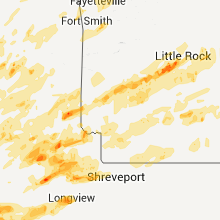
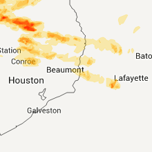
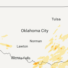
Hail Map for Monday, April 25, 2011

Number of Impacted Households on 4/25/2011
0
Impacted by 1" or Larger Hail
0
Impacted by 1.75" or Larger Hail
0
Impacted by 2.5" or Larger Hail
Square Miles of Populated Area Impacted on 4/25/2011
0
Impacted by 1" or Larger Hail
0
Impacted by 1.75" or Larger Hail
0
Impacted by 2.5" or Larger Hail


Cities Most Affected by Hail Storms of 4/25/2011
| Hail Size | Demographics of Zip Codes Affected | ||||||
|---|---|---|---|---|---|---|---|
| City | Count | Average | Largest | Pop Density | House Value | Income | Age |
| Teague, TX | 3 | 1.83 | 2.00 | 32 | $49k | $30.6k | 39.8 |
| Mexia, TX | 3 | 1.75 | 1.75 | 76 | $42k | $28.0k | 37.5 |
| Elkhart, TX | 3 | 1.75 | 1.75 | 31 | $55k | $31.0k | 40.1 |
| Fairfield, TX | 2 | 2.13 | 2.50 | 24 | $61k | $33.2k | 38.7 |
| Little Rock, AR | 2 | 1.75 | 1.75 | 2149 | $114k | $51.7k | 38.6 |
| Waco, TX | 2 | 1.75 | 1.75 | 411 | $45k | $27.5k | 30.2 |
| Driftwood, PA | 2 | 1.75 | 1.75 | 3 | $43k | $26.1k | 53.7 |
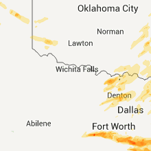
| Ponder, TX | 1 | 2.50 | 2.50 | 71 | $109k | $53.4k | 36.1 |
| Corsicana, TX | 1 | 1.75 | 1.75 | 203 | $61k | $30.4k | 34.3 |
| Gainesville, TX | 1 | 1.75 | 1.75 | 74 | $70k | $35.5k | 38.3 |
| New Milford, PA | 1 | 1.75 | 1.75 | 46 | $86k | $32.5k | 45.0 |
| Campbell, TX | 1 | 1.75 | 1.75 | 35 | $70k | $39.3k | 42.7 |
| Grapeland, TX | 1 | 1.75 | 1.75 | 12 | $50k | $28.6k | 47.4 |
| Oakwood, TX | 1 | 1.75 | 1.75 | 8 | $57k | $27.8k | 48.7 |
| Zavalla, TX | 1 | 1.75 | 1.75 | 12 | $48k | $26.3k | 49.1 |
| Hot Springs National Park, AR | 1 | 1.75 | 1.75 | 295 | $73k | $26.0k | 41.1 |
| Frankston, TX | 1 | 1.75 | 1.75 | 48 | $79k | $33.2k | 43.9 |
| Royal, AR | 1 | 1.75 | 1.75 | 44 | $69k | $36.5k | 42.3 |
| Larue, TX | 1 | 1.75 | 1.75 | 23 | $54k | $35.6k | 43.7 |
| Wortham, TX | 1 | 1.75 | 1.75 | 16 | $43k | $28.2k | 39.0 |
| Troup, TX | 1 | 1.75 | 1.75 | 39 | $59k | $39.1k | 40.1 |
| Blair, OK | 1 | 1.75 | 1.75 | 13 | $52k | $31.5k | 40.4 |
| Mount Calm, TX | 1 | 1.75 | 1.75 | 12 | $43k | $32.4k | 40.8 |
| Martha, OK | 1 | 1.75 | 1.75 | 0 | $39k | $27.2k | 36.0 |
| Granbury, TX | 1 | 1.75 | 1.75 | 224 | $89k | $38.0k | 44.5 |
| Krum, TX | 1 | 1.75 | 1.75 | 112 | $97k | $53.6k | 34.5 |
Hail and Wind Damage Spotted on 4/25/2011
Filter by Report Type:Hail ReportsWind Reports
States Impacted
Arkansas, Texas, Oklahoma, Tennessee, Louisiana, Georgia, Pennsylvania, Virginia, West Virginia, Idaho, South Carolina, Kansas, Ohio, Kentucky, Missouri, Utah, Illinois, Mississippi, Alabama, IndianaArkansas
| Local Time | Report Details |
|---|---|
| 12:05 PM UTC | Tree down in the wilton communit in little river county AR, 22.6 miles SW of Nashville, AR |
| 12:20 PM UTC | Tree downed along hwy. 27 near the saline rive in howard county AR, 6.3 miles SW of Nashville, AR |
| 1:07 PM UTC | Four power pole and a large pine tree were blown down along hwy 7 on the hot spring and clark county borde in clark county AR, 45.8 miles ENE of Nashville, AR |
| 1:07 PM UTC | Four power poles and a large pine tree were blown down along hwy 7 on the hot spring and clark county borde in clark county AR, 45.8 miles ENE of Nashville, AR |
| 2:10 PM UTC | 10 trees down north of fulton in hempstead county AR, 21.3 miles S of Nashville, AR |
| 2:15 PM UTC | Trees down between washington and oakhave in hempstead county AR, 15.6 miles SE of Nashville, AR |
| 7:47 PM UTC | Several trees reported down in the shady communit in polk county AR, 38.2 miles NNW of Nashville, AR |
| 8:18 PM UTC | Trees down and stuctural damage between big fork and opa in polk county AR, 40.3 miles NNW of Nashville, AR |
| 9:39 PM UTC | Trees were blown down on highway 18 in clark county AR, 35 miles NE of Nashville, AR |
| 9:39 PM UTC | A tree was blown down on a ca in montgomery county AR, 35.5 miles NE of Nashville, AR |
| 9:49 PM UTC | Trees were blown down on the bonnerdale fire statio in hot spring county AR, 40 miles NE of Nashville, AR |
| 10:07 PM UTC | *** 2 inj *** houses were damaged...with people trapped insid in garland county AR, 50.3 miles NE of Nashville, AR |
| 10:07 PM UTC | A roof was blown off of a house at brady mountain road and owl creek roa in garland county AR, 53 miles NE of Nashville, AR |
| 10:07 PM UTC | Structural damage was reported at ragweed valley...which is about five miles west of roya in garland county AR, 49.7 miles NE of Nashville, AR |
| 10:15 PM UTC | Large trees were blown down on houses and power lines near brady mountai in garland county AR, 54.7 miles NE of Nashville, AR |
| 10:21 PM UTC | Considerable damage was reported at lake ouachita state par in garland county AR, 52.9 miles W of Little Rock, AR |
| 10:44 PM UTC | A tree was blown down...and is blocking highway 7 in hot spring county AR, 40 miles NE of Nashville, AR |
| 11:01 PM UTC | Quarter sized hail reported near Pearcy, AR, 50.4 miles NE of Nashville, AR |
| 11:07 PM UTC | Golf Ball sized hail reported near Royal, AR, 50.4 miles NE of Nashville, AR |
| 6:10 PM CDT | Quarter sized hail reported near Hot Springs National Park, AR, 52.2 miles WSW of Little Rock, AR |
| 6:13 PM CDT | Quarter sized hail reported near Hot Springs, AR, 47.7 miles WSW of Little Rock, AR, quarter sized hail was reported 1 mile west of hot springs airport. |
| 6:15 PM CDT | Golf Ball sized hail reported near Hot Springs, AR, 47.7 miles WSW of Little Rock, AR |
| 11:17 PM UTC | An nws storm survey team determined that the wind damage east of nashville was consistent with straight line wind damage in association with a bow echo. several scatter in hempstead county AR, 2.7 miles NE of Nashville, AR |
| 11:27 PM UTC | Trees down on county road 27 near the intersecion of cr 33 in hempstead county AR, 5 miles E of Nashville, AR |
| 11:34 PM UTC | Trees were blown down on house in saline county AR, 27.1 miles W of Little Rock, AR |
| 11:35 PM UTC | Trees were reported down in perryvill in perry county AR, 34.9 miles WNW of Little Rock, AR |
| 11:40 PM UTC | Storm damage reported in conway county AR, 37.6 miles NW of Little Rock, AR |
| 11:45 PM UTC | Storm damage reported in conway county AR, 37.6 miles NW of Little Rock, AR |
| 11:45 PM UTC | Barn destroyed and numerous trees downed along cr 33 near bingen in hempstead county AR, 4 miles NE of Nashville, AR |
| 11:48 PM UTC | Storm damage reported in pulaski county AR, 18.4 miles WNW of Little Rock, AR |
| 11:51 PM UTC | Highway 7 was blocked by debris in garland county AR, 41.7 miles W of Little Rock, AR |
| 11:52 PM UTC | A tree was blown down on a house on fairplay roa in saline county AR, 29.7 miles WSW of Little Rock, AR |
| 11:53 PM UTC | Storm damage reported in garland county AR, 50.4 miles NE of Nashville, AR |
| 11:55 PM UTC | Storm spotter estimates 60 mph wind. trees blown down across hwy 71 south completely blocking the hw in little river county AR, 27.7 miles SSW of Nashville, AR |
| 12:01 AM UTC | A tree was blown down on a mobile hom in saline county AR, 21.3 miles SW of Little Rock, AR |
| 12:04 AM UTC | A 63 mph wind gust was measured at the hot springs airpor in garland county AR, 47.7 miles WSW of Little Rock, AR |
| 12:06 AM UTC | A church was destroyed...with people injure in pulaski county AR, 10.6 miles NNW of Little Rock, AR |
| 12:08 AM UTC | Many trees were blown down...with some roof damage. a car was blown off the road. time is approximated based on rada in faulkner county AR, 32.7 miles NNW of Little Rock, AR |
| 12:10 AM UTC | Major damage has been reported along highway 89. power lines were down...and a vehicle was blown off the road. there is at least a half mile wide swath of downed tree in faulkner county AR, 16.8 miles NNW of Little Rock, AR |
| 12:11 AM UTC | Quarter sized hail reported near Malvern, AR, 40.6 miles SW of Little Rock, AR |
| 12:11 AM UTC | Trees and power lines were blown dow in faulkner county AR, 33.3 miles NNW of Little Rock, AR |
| 12:15 AM UTC | Trees were blown down on houses in alexande in saline county AR, 12.5 miles SW of Little Rock, AR |
| 12:15 AM UTC | A tree was blown down on a hous in saline county AR, 13.9 miles S of Little Rock, AR |
| 12:16 AM UTC | *** 1 inj *** windows blown out of a car on interstate 4 in pulaski county AR, 10.6 miles NNW of Little Rock, AR |
| 12:18 AM UTC | Trees and power lines were blown dow in lonoke county AR, 21 miles NE of Little Rock, AR |
| 12:18 AM UTC | A large tree fell onto highway 30 in pulaski county AR, 13.9 miles NW of Little Rock, AR |
| 7:19 PM CDT | Golf Ball sized hail reported near Little Rock, AR, 9.3 miles WNW of Little Rock, AR |
| 12:20 AM UTC | Quarter sized hail reported near Little Rock, AR, 6.7 miles W of Little Rock, AR |
| 12:25 AM UTC | Golf Ball sized hail reported near Little Rock, AR, 5 miles WSW of Little Rock, AR |
| 12:29 AM UTC | Trees and power lines were blown dow in pulaski county AR, 4.8 miles WNW of Little Rock, AR |
| 7:30 PM CDT | An 18 wheeler was blown ove in faulkner county AR, 29.3 miles N of Little Rock, AR |
| 12:45 AM UTC | Trees were blown down in the lakewood area of north little roc in pulaski county AR, 4 miles NNE of Little Rock, AR |
| 12:46 AM UTC | Storm damage reported in pulaski county AR, 3.4 miles ESE of Little Rock, AR |
| 12:50 AM UTC | Trees were blown down on house in pulaski county AR, 6.4 miles ENE of Little Rock, AR |
| 12:52 AM UTC | Trees and power lines were blown down...and structural damage occurre in pulaski county AR, 14.2 miles NNE of Little Rock, AR |
| 12:58 AM UTC | Storm damage reported in pulaski county AR, 13.8 miles NNE of Little Rock, AR |
| 1:00 AM UTC | Storm damage reported in lonoke county AR, 21 miles NE of Little Rock, AR |
| 1:00 AM UTC | Trees and power lines were blown dow in lonoke county AR, 21 miles NE of Little Rock, AR |
| 1:02 AM UTC | Power lines were down near maddox and mckenzie road north of the air bas in pulaski county AR, 14.4 miles NNE of Little Rock, AR |
| 1:05 AM UTC | Trees were blown down...with one on a house. power lines were blown down. roof damage was noted...as well as damage to a storage buildin in lonoke county AR, 21.5 miles E of Little Rock, AR |
| 1:06 AM UTC | Storm damage reported in lonoke county AR, 21 miles NE of Little Rock, AR |
| 1:06 AM UTC | Quarter sized hail reported near Lonoke, AR, 21.5 miles E of Little Rock, AR |
| 1:17 AM UTC | State police relayed a report of 60 to 70 mph winds in stamps arkansas in lafayette county AR, 45.2 miles SSE of Nashville, AR |
| 1:25 AM UTC | Trees and power lines were blown dow in white county AR, 31.1 miles NE of Little Rock, AR |
| 1:47 AM UTC | Trees were blown dow in woodruff county AR, 65.6 miles W of Memphis, TN |
| 2:40 AM UTC | Trees and power lines down on highway 7 in poinsett county AR, 31.5 miles NW of Memphis, TN |
| 2:40 AM UTC | Trees and power lines down on highway 7 in crittenden county AR, 27.2 miles NW of Memphis, TN |
| 2:45 AM UTC | Volunteer fire truck blown off road into ditch. winds estimated at 70-75mp in cross county AR, 43 miles WNW of Memphis, TN |
| 3:10 AM UTC | Road signs blown over along state highway 135 one mile north of caraway. winds estimated at 60-70mp in craighead county AR, 45.6 miles NNW of Memphis, TN |
| 3:13 AM UTC | Two 18 wheeler trucks overturned in the median on interstate 55 in mississippi county AR, 35.2 miles N of Memphis, TN |
| 3:27 AM UTC | Tree limbs broken and down by ems statio in union county AR, 49.7 miles NW of Bastrop, LA |
| 3:39 AM UTC | Storm damage reported in mississippi county AR, 54.3 miles N of Memphis, TN |
Texas
| Local Time | Report Details |
|---|---|
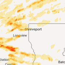
| 12:10 PM UTC | Trees down across the roads in pittsburg in camp county TX, 78.7 miles WNW of Shreveport, LA |
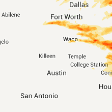
| 3:40 PM UTC | Quarter sized hail reported near Garland, TX, 13.7 miles NE of Dallas, TX, nickels to quarters. 45 to 55 mph winds measured with anemometer |
| 3:48 PM UTC | Quarter sized hail reported near Wylie, TX, 21.9 miles NE of Dallas, TX, nickel to quarter size hail reported by public |
| 7:05 PM UTC | Golf Ball sized hail reported near Gainesville, TX, 72.1 miles E of Wichita Falls, TX |
| 2:30 PM CDT | Tennis Ball sized hail reported near Ponder, TX, 46.1 miles NW of Dallas, TX, 2-2.5 inch hail reported at 2622 and 380 |
| 7:35 PM UTC | Quarter sized hail reported near Teague, TX, 86.1 miles WNW of Lufkin, TX |
| 7:38 PM UTC | Golf Ball sized hail reported near Granbury, TX, 65.1 miles WSW of Dallas, TX |
| 2:47 PM CDT | Golf Ball sized hail reported near Krum, TX, 44.6 miles NW of Dallas, TX |
| 7:49 PM UTC | Trees down 6 miles north of palestine in anderson county TX, 65.4 miles WNW of Lufkin, TX |
| 7:50 PM UTC | Quarter sized hail reported near Granbury, TX, 61 miles WSW of Dallas, TX, one inch hail in pecan plantation. |
| 3:35 PM CDT | Golf Ball sized hail reported near Troup, TX, 59.8 miles NNW of Lufkin, TX |
| 8:42 PM UTC | Golf Ball sized hail reported near Frankston, TX, 67.1 miles NW of Lufkin, TX, golfball hail in frankston. |
| 8:46 PM UTC | Large limbs greater than 2 inches down in meliss in collin county TX, 36.8 miles NNE of Dallas, TX |
| 9:00 PM UTC | Half Dollar sized hail reported near Mt Pleasant, TX, 84.5 miles SW of Nashville, AR, report relayed through media |
| 9:06 PM UTC | Quarter sized hail reported near Trenton, TX, 51.8 miles NNE of Dallas, TX, one inch hail in tr |
| 9:15 PM UTC | Estimated 70 mph winds and three-quarter inch hail in meliss in collin county TX, 36.8 miles NNE of Dallas, TX |
| 4:25 PM CDT | Quarter sized hail reported near Sulphur Springs, TX, 73.6 miles ENE of Dallas, TX, quarter size hail in sulphur springs. reported by emergency manager. |
| 9:34 PM UTC | Quarter sized hail reported near Itasca, TX, 45.9 miles SSW of Dallas, TX, quarter hail at mile marker 11 on i-35w near itasca. |
| 9:40 PM UTC | Deputy reported in hopkins county TX, 82.5 miles ENE of Dallas, TX |
| 9:40 PM UTC | Several trees down in dike in hopkins county TX, 82.5 miles ENE of Dallas, TX |
| 9:40 PM UTC | Quarter sized hail reported near Ladonia, TX, 65.2 miles NE of Dallas, TX, quarter size hail reported in ladonia. |
| 9:45 PM UTC | Half Dollar sized hail reported near Miami, TX, 67.8 miles NE of Amarillo, TX |
| 9:48 PM UTC | Quarter sized hail reported near Grandview, TX, 41.6 miles SSW of Dallas, TX, quarter size hail in grandview. |
| 4:55 PM CDT | Several travel trailers blown in hopkins county TX, 73.6 miles ENE of Dallas, TX |
| 10:00 PM UTC | Large trees limbs broken by high winds in pari in lamar county TX, 61.2 miles SE of Atoka, OK |
| 10:10 PM UTC | Golf Ball sized hail reported near Lacy-Lakeview, TX, 50.8 miles NE of Killeen, TX, golfball size hail in lacy-lakeview. |
| 10:15 PM UTC | Tree down near cr 1915 in titus county TX, 82.8 miles WSW of Nashville, AR |
| 10:17 PM UTC | Golf Ball sized hail reported near Waco, TX, 45.3 miles NE of Killeen, TX, quarter to golfball size hail near hwy 84/hwy 31 split. |
| 10:21 PM UTC | Ping Pong Ball sized hail reported near Waco, TX, 45.3 miles NE of Killeen, TX, ping pong size hail at texas state technical college in ne side of town. |
| 5:23 PM CDT | Roof tore off a residence and damage to the avalon schoo in ellis county TX, 39.9 miles S of Dallas, TX |
| 5:24 PM CDT | Quarter sized hail reported near Waxahachie, TX, 35 miles S of Dallas, TX, quarter hail in nash. |
| 10:26 PM UTC | Half Dollar sized hail reported near Mobeetie, TX, 77 miles N of Childress, TX, quarter to half dollar size hail falling. |
| 5:28 PM CDT | Estimated 100 mph winds in ellis county TX, 35.5 miles S of Dallas, TX |
| 5:30 PM CDT | Numerous trees flattened in bardwel in ellis county TX, 35.5 miles S of Dallas, TX |
| 10:34 PM UTC | Trees down along highway 69 near cune in cherokee county TX, 63.4 miles NW of Lufkin, TX |
| 10:39 PM UTC | Golf Ball sized hail reported near Mt Calm, TX, 66.4 miles NE of Killeen, TX |
| 5:39 PM CDT | Golf Ball sized hail reported near Campbell, TX, 54.4 miles ENE of Dallas, TX, golfball size hail reported near campbell on |
| 10:50 PM UTC | Tree down at fm 1840 and county road 4114 in bowie county TX, 53.8 miles SW of Nashville, AR |
| 6:00 PM CDT | Numerous trees down and structure damage west of emhouse on fm112 in navarro county TX, 43 miles SSE of Dallas, TX |
| 11:03 PM UTC | Golf Ball sized hail reported near Corsicana, TX, 50.5 miles SSE of Dallas, TX, golfball size hail in corsicana. |
| 11:11 PM UTC | Quarter sized hail reported near Mexia, TX, 77.6 miles SSE of Dallas, TX, quarter size hail reported in mexia. |
| 11:12 PM UTC | Quarter sized hail reported near Penelope, TX, 64.4 miles S of Dallas, TX, quarter size hail reported 1sw of p |
| 11:15 PM UTC | Quarter sized hail reported near Como, TX, 79.6 miles ENE of Dallas, TX, quarter hail and 60 mph winds estimated in como |
| 6:19 PM CDT | Wind damage with signs blown down on sr 2 in navarro county TX, 50.5 miles SSE of Dallas, TX |
| 6:22 PM CDT | Quarter sized hail reported near Italy, TX, 41.5 miles S of Dallas, TX, quarter size hail reported in italy. |
| 11:22 PM UTC | Golf Ball sized hail reported near Mexia, TX, 77.6 miles SSE of Dallas, TX, golfball size hail reported in mexia. |
| 11:27 PM UTC | Golf Ball sized hail reported near Mexia, TX, 76.7 miles SSE of Dallas, TX, golfball size hail reported west side of mexia. |
| 11:34 PM UTC | Quarter sized hail reported near Malakoff, TX, 69.6 miles SE of Dallas, TX, quarter inch size hail reported in cross roads. |
| 11:45 PM UTC | Large trees down south side of athens in henderson county TX, 68.1 miles SE of Dallas, TX |
| 11:50 PM UTC | Golf Ball sized hail reported near Teague, TX, 85.3 miles SSE of Dallas, TX, golfball size hail reported in teague. |
| 11:55 PM UTC | Hen Egg sized hail reported near Teague, TX, 85.3 miles SSE of Dallas, TX, spotter reports hail up to 2.25 inches in diameter west of teague. |
| 11:57 PM UTC | Estimated 60 mph wind and heavy rain in bowie county TX, 38.6 miles SSW of Nashville, AR |
| 12:01 AM UTC | Large tree on house at fm 21 about 1 mile off hwy 11 wes in camp county TX, 77.5 miles WNW of Shreveport, LA |
| 12:01 AM UTC | Storage building blown down on hwy 21 in camp county TX, 81.1 miles WNW of Shreveport, LA |
| 12:01 AM UTC | Two telephone lines broken off hwy 11 in camp county TX, 81.1 miles WNW of Shreveport, LA |
| 12:03 AM UTC | Golf Ball sized hail reported near Mexia, TX, 71.1 miles SSE of Dallas, TX, golfball size hail fell 1w of wortham. |
| 12:05 AM UTC | Storm damage reported in bowie county TX, 37.3 miles SSW of Nashville, AR |
| 12:05 AM UTC | Trees in camp county TX, 80.2 miles WNW of Shreveport, LA |
| 12:09 AM UTC | Large tree limbs down and a metal car canopy blew onto a nearby hwy 1n of malakof in henderson county TX, 68.1 miles SE of Dallas, TX |
| 7:09 PM CDT | High winds knocked large tree limbs down and blew a metal car canopy onto a nearby hwy 1n of malakof in henderson county TX, 60.3 miles SE of Dallas, TX |
| 12:10 AM UTC | Trees down across the roads in pittsburg in camp county TX, 78.7 miles WNW of Shreveport, LA |
| 7:10 PM CDT | Quarter sized hail reported near Corsicana, TX, 59.7 miles SSE of Dallas, TX |
| 12:12 AM UTC | *** 1 inj *** tree fell on vehicle with person inside. person taken to hospital but minor injuries in pittsbur in camp county TX, 78.7 miles WNW of Shreveport, LA |
| 12:12 AM UTC | Golf Ball sized hail reported near Larue, TX, 78 miles NW of Lufkin, TX |
| 12:15 AM UTC | Numerous trees down on homes near lake cypress springs with several roofs damaged in franklin county TX, 91.8 miles WNW of Shreveport, LA |
| 12:17 AM UTC | Golf Ball sized hail reported near Kirvin, TX, 74.6 miles SSE of Dallas, TX, golfball size hail report kirvin. |
| 12:20 AM UTC | Golf Ball sized hail reported near Teague, TX, 87 miles W of Lufkin, TX |
| 12:27 AM UTC | Quarter sized hail reported near Fairfield, TX, 81.6 miles SSE of Dallas, TX, quarter size hail reported in fairfield. |
| 12:27 AM UTC | Quarter sized hail reported near Hughes Springs, TX, 66.5 miles NW of Shreveport, LA, storm spotter reported quarter sized hail |
| 12:31 AM UTC | Tennis Ball sized hail reported near Fairfield, TX, 81.6 miles SSE of Dallas, TX, up to tennisball size hail in fairfield. |
| 12:32 AM UTC | Golf Ball sized hail reported near Fairfield, TX, 82.3 miles SSE of Dallas, TX, golfball size hail reported 2 miles sw of fairfield. |
| 12:38 AM UTC | Golf Ball sized hail reported near Oakwood, TX, 64.8 miles W of Lufkin, TX |
| 12:56 AM UTC | Numerous trees down. trees on hous in camp county TX, 80.8 miles WNW of Shreveport, LA |
| 1:04 AM UTC | 5 to 10 inch diameter trees blown down 1 nnw of kecch in leon county TX, 73.8 miles W of Lufkin, TX |
| 1:12 AM UTC | Trees down hwy 155 at 2796 at begonia in upshur county TX, 62.8 miles WNW of Shreveport, LA |
| 1:27 AM UTC | Golf Ball sized hail reported near Elkhart, TX, 54.4 miles WNW of Lufkin, TX, quarter to golfball sized hail reported in elkhart. 12 inch tree also knocked down across from fm861. |
| 1:41 AM UTC | Quarter sized hail reported near Grapeland, TX, 46.5 miles WNW of Lufkin, TX |
| 1:45 AM UTC | Quarter sized hail reported near Grapeland, TX, 45 miles WNW of Lufkin, TX, nickle to quarter sized hail reported. |
| 1:58 AM UTC | Golf Ball sized hail reported near Elkhart, TX, 50.7 miles WNW of Lufkin, TX, golfball hail se of elkhart. |
| 1:58 AM UTC | Golf Ball sized hail reported near Elkhart, TX, 56.3 miles WNW of Lufkin, TX |
| 2:14 AM UTC | Golf Ball sized hail reported near Grapeland, TX, 45 miles WNW of Lufkin, TX, lots of nickel sized hail with a few hail stones as large as golf balls. |
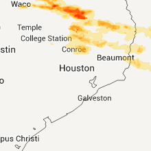
| 2:18 AM UTC | 2 mobile homes damaged one severely. no one injured. time estimate in houston county TX, 44.5 miles W of Lufkin, TX |
| 2:20 AM UTC | Quarter sized hail reported near Crockett, TX, 44.6 miles W of Lufkin, TX |
| 2:35 AM UTC | A 2 mile swath of severe wind damage in association with the rear flank downdraft from the wells tornado. minor roof damage occurred to homes along fm 1819. the old red in angelina county TX, 16.7 miles NW of Lufkin, TX |
| 2:37 AM UTC | Trees down and blocking highway 21 eas in houston county TX, 38.1 miles W of Lufkin, TX |
| 3:13 AM UTC | A one half mile wide damage path in association with the rear flank downdraft of the lufkin tornado resulted in several trees uprooted or snapped blocking portions of b in angelina county TX, 1.1 miles SW of Lufkin, TX |
| 3:27 AM UTC | Numerous trees down throughout the county including 94 west...103 west...fm 1819 and chopin roa in angelina county TX, 1.1 miles SW of Lufkin, TX |
| 3:40 AM UTC | Nws storm survey noted a few trees and numerous tree limbs were blown down along hwy. 69 from south of huntington to the jasper county line. winds were estimated at 60- in angelina county TX, 9.2 miles ESE of Lufkin, TX |
| 3:50 AM UTC | Golf Ball sized hail reported near Zavalla, TX, 21.7 miles SE of Lufkin, TX |
| 4:13 AM UTC | Numerous trees were snapped and uprooted along and east of hwy. 63 to the western shore of lake sam rayburn to just north of the jasper county line. winds were estimate in angelina county TX, 21.7 miles SE of Lufkin, TX |
| 4:35 AM UTC | Quarter sized hail reported near Jasper, TX, 47.6 miles ESE of Lufkin, TX, public reported quarter size hail at hwy 96 and fm 255. time estimated based on radar |
| 4:40 AM UTC | Jasper sheriff reports trees down on roads near brookeland as well as dime size hai in jasper county TX, 45.5 miles ESE of Lufkin, TX |
| 4:53 AM UTC | Kjas radio reported tree limbs and power lines down across jasper. time estimated based on radar in jasper county TX, 51.6 miles SE of Lufkin, TX |
| 5:15 AM UTC | Walker county sherrif had numerous reports of trees down in and around riversid in walker county TX, 52.8 miles SW of Lufkin, TX |
| 6:50 AM UTC | Trees down about 3 miles south-southeast of livingsto in polk county TX, 47.8 miles SSW of Lufkin, TX |
| 6:55 AM UTC | Public reported a tree down in buna via facebook in jasper county TX, 27.4 miles NNW of Beaumont, TX |
| 7:00 AM UTC | Quarter sized hail reported near Fred, TX, 42.7 miles NW of Beaumont, TX |
| 7:05 AM UTC | Kbmt-tv reported tree blown down on a house with people trapped inside on hwy 96 near silsbee in hardin county TX, 33.5 miles NW of Beaumont, TX |
| 7:10 AM UTC | Tree down on a mobile home in segn in polk county TX, 52.5 miles S of Lufkin, TX |
| 7:59 AM UTC | Nws storm survey found a few trees blown down along hwy 69 near village mills in hardin county TX, 48.2 miles NW of Beaumont, TX |
| 8:59 AM UTC | Nws storm survey found a few trees blown down along hwy 87 near forest heights in orange county TX, 10.3 miles N of Beaumont, TX |
Oklahoma
| Local Time | Report Details |
|---|---|
| 3:30 PM UTC | Half Dollar sized hail reported near Salina, OK, 58.2 miles ENE of Tulsa, OK |
| 4:25 PM UTC | Half Dollar sized hail reported near Wetumka, OK, 59.2 miles N of Atoka, OK |
| 4:57 PM UTC | Quarter sized hail reported near Calvin, OK, 41.1 miles NNW of Atoka, OK |
| 5:45 PM UTC | Trees reported dow in mccurtain county OK, 67.2 miles W of Nashville, AR |
| 7:04 PM UTC | Quarter sized hail reported near Marietta, OK, 68.8 miles WSW of Atoka, OK |
| 7:16 PM UTC | Quarter sized hail reported near Boswell, OK, 28.6 miles SSE of Atoka, OK, also very gusty...but no damage. |
| 7:30 PM UTC | Large limbs broken from trees in mcintosh county OK, 54.3 miles W of Fort Smith, AR |
| 8:00 PM UTC | Quarter sized hail reported near Hartshorne, OK, 32.3 miles NE of Atoka, OK, pea up to quarter size. |
| 8:40 PM UTC | Quarter sized hail reported near Idabel, OK, 56 miles W of Nashville, AR |
| 8:41 PM UTC | Half Dollar sized hail reported near Idabel, OK, 56 miles W of Nashville, AR, hail fell for about 1 minute |
| 9:10 PM UTC | Tree damage. one tree blown down onto mobile hom in pushmataha county OK, 41 miles E of Atoka, OK |
| 9:38 PM UTC | Golf Ball sized hail reported near Blair, OK, 55.7 miles ENE of Childress, TX, emergency manager reports golf ball sized hail in blair. |
| 9:45 PM UTC | Golf Ball sized hail reported near Martha, OK, 51.2 miles ENE of Childress, TX, public reports golfball sized hail in the martha area. |
| 10:15 PM UTC | Quarter sized hail reported near Altus, OK, 52.3 miles ENE of Childress, TX, multiple reports of nickle to quarter sized hail in the altus area. |
| 10:19 PM UTC | Roof off a general store...several car ports flipped...trees down on powerline in mccurtain county OK, 41.9 miles W of Nashville, AR |
| 10:20 PM UTC | Tin roof blow off a building. trees and powerlines downe in mccurtain county OK, 41.9 miles W of Nashville, AR |
| 11:20 PM UTC | Quarter sized hail reported near Erick, OK, 57.2 miles NNE of Childress, TX |
| 12:22 AM UTC | Quarter sized hail reported near Broken Bow, OK, 51.6 miles W of Nashville, AR, quarter size hail in broken bow. |
Tennessee
| Local Time | Report Details |
|---|---|
| 5:30 PM UTC | Large tree limbs down in the belle trees neigborhoo in shelby county TN, 14.2 miles E of Memphis, TN |
| 5:30 PM UTC | Trees down in the belle trees neigborhoo in shelby county TN, 14.2 miles E of Memphis, TN |
| 8:36 PM UTC | Quarter sized hail reported near Limestone, TN, 32.7 miles SW of Bristol, TN, 1 inch size hail in te |
| 8:43 PM UTC | A couple trees were blown dow in stewart county TN, 50.4 miles NE of Mc Kenzie, TN |
| 8:45 PM UTC | Quarter sized hail reported near Kingsport, TN, 19.3 miles WSW of Bristol, TN |
| 9:10 PM UTC | A few trees and power lines down near johnson cit in washington county TN, 19.9 miles SSW of Bristol, TN |
| 9:40 PM UTC | Several trees down countywide. reported by dispatc in monroe county TN, 39.1 miles SW of Knoxville, TN |
| 9:52 PM UTC | One tree down near the loudon county line. reported by dispatch in monroe county TN, 35.7 miles SW of Knoxville, TN |
| 10:12 PM UTC | Numerous trees and powerlines down across the eastern half of the county. reported by dispatc in loudon county TN, 29 miles WSW of Knoxville, TN |
| 10:15 PM UTC | Storm damage reported in blount county TN, 11.3 miles SSW of Knoxville, TN |
| 10:30 PM UTC | Several buildings damaged and/or destroyed on u.t. hospital property. reported by ham radio operator via mrxwrkal in knox county TN, 2.8 miles WSW of Knoxville, TN |
| 10:30 PM UTC | Numerous trees downed and blocking all entrances and exits to martha washington heights subdivision. reported by ham radio operator via mrxwrkal in knox county TN, 3.6 miles WSW of Knoxville, TN |
| 10:45 PM UTC | Several trees down countywide. reported by matt hinke in knox county TN, 1.8 miles WNW of Knoxville, TN |
| 11:10 PM UTC | Numerous trees and powerlines down countywide. reported by dispatc in union county TN, 20.9 miles NNE of Knoxville, TN |
| 11:46 PM UTC | Several trees and powerlines down across the eastern third of the county. reported by dispatc in claiborne county TN, 44 miles NE of Knoxville, TN |
| 11:53 PM UTC | One tree down on highway 63 near the claiborne county line. reported by dispatc in hancock county TN, 52.9 miles NE of Knoxville, TN |
| 3:35 AM UTC | Fence blown over at the corner of raines and kirby across from kirby high s in shelby county TN, 10.4 miles ESE of Memphis, TN |
| 3:37 AM UTC | Storm damage reported in tipton county TN, 26 miles NE of Memphis, TN |
| 3:45 AM UTC | Tree down on house. roof and structural damag in lauderdale county TN, 50.7 miles NE of Memphis, TN |
| 3:55 AM UTC | Five foot diameter tree down crossing highway 19 in fayette county TN, 25.1 miles ESE of Memphis, TN |
| 4:00 AM UTC | Trees and powerlines down and blocking interstate 40 in haywood county between mile markers 41 through 6 in haywood county TN, 54.4 miles NE of Memphis, TN |
| 4:00 AM UTC | A wooden porch was torn from a house...shingles also blown of hous in dyer county TN, 47.5 miles W of Mc Kenzie, TN |
| 4:08 AM UTC | Storm damage reported in dyer county TN, 48.1 miles W of Mc Kenzie, TN |
| 4:15 AM UTC | 2 large poplar trees down along with multiple limb in crockett county TN, 35.5 miles SW of Mc Kenzie, TN |
| 4:18 AM UTC | Numerous trees down. a tree fell on a house with a possible entrapment. poplar corner church steeple blown of in madison county TN, 40.7 miles SW of Mc Kenzie, TN |
| 4:20 AM UTC | A municipal storage building was damaged and the roof was ripped off. multiple large trees were knocked down. a mobile home was destroyed. multiple power lines were kno in obion county TN, 38.5 miles WNW of Mc Kenzie, TN |
| 4:20 AM UTC | Power pole snapped in half and many trees down between bells and jackso in madison county TN, 41.2 miles SW of Mc Kenzie, TN |
| 4:23 AM UTC | Storm damage reported in madison county TN, 38.8 miles SSW of Mc Kenzie, TN |
| 4:24 AM UTC | Large trees down on a house on christmasville roa in madison county TN, 36.3 miles SW of Mc Kenzie, TN |
| 4:24 AM UTC | Trees down at the hwy 45 bypass and highland avenue near porter cabl in madison county TN, 33.4 miles SSW of Mc Kenzie, TN |
| 4:24 AM UTC | Public reports downed trees blocking old jackson road near trento in gibson county TN, 25.1 miles WSW of Mc Kenzie, TN |
| 4:25 AM UTC | Trees down on a house on southern street. person is missin in madison county TN, 38.8 miles SSW of Mc Kenzie, TN |
| 4:27 AM UTC | Storm damage reported in crockett county TN, 39.8 miles SW of Mc Kenzie, TN |
| 4:30 AM UTC | Estimated wind speed. large trees and power lines down on n. highland ave near northside high school. trees and power lines also down at the intersection of east forest in madison county TN, 38.8 miles SSW of Mc Kenzie, TN |
| 4:30 AM UTC | A nursing home in jackson sustained damage with trees down on building. evacuations in progres in madison county TN, 38.8 miles SSW of Mc Kenzie, TN |
| 4:30 AM UTC | Trees down on hwy 104...milan highway...near the town of trento in gibson county TN, 26.1 miles WSW of Mc Kenzie, TN |
| 4:32 AM UTC | Storm damage reported in madison county TN, 35.1 miles SSW of Mc Kenzie, TN |
| 4:32 AM UTC | Trees were down. a fence door was also broken at the hing in madison county TN, 38.8 miles SSW of Mc Kenzie, TN |
| 4:36 AM UTC | Large trees down on the south side of tow in gibson county TN, 19.5 miles SW of Mc Kenzie, TN |
| 4:42 AM UTC | Several trees dow in weakley county TN, 18.1 miles WNW of Mc Kenzie, TN |
| 4:45 AM UTC | Widespread wind damage reported across all of carroll county tennessee as reported by carroll county ema. widespread trees and power lines down. many roads are impassab in carroll county TN, 10.4 miles SSW of Mc Kenzie, TN |
| 4:50 AM UTC | Numerous trees and power lines down. 100 light poles down. unreinforced structures were destroyed. several homes destroyed by falling trees. the majority of the damage in weakley county TN, 23.8 miles NW of Mc Kenzie, TN |
| 5:00 AM UTC | Trees down on 2 mobile homes in the town of henry. people trappe in henry county TN, 7.7 miles NE of Mc Kenzie, TN |
| 5:06 AM UTC | Utility pole on a house on springhill roa in henry county TN, 13.9 miles ENE of Mc Kenzie, TN |
| 5:07 AM UTC | Tree and structual damage at natchez trace state forest. possible tornado damag in carroll county TN, 25.8 miles SE of Mc Kenzie, TN |
| 5:08 AM UTC | Several large trees dow in henry county TN, 21.3 miles ENE of Mc Kenzie, TN |
| 5:08 AM UTC | Trees and power lines down across the county. old mckenzie road...highway 69 south...and jones bend roa in henry county TN, 16.4 miles NE of Mc Kenzie, TN |
| 5:12 AM UTC | Trees down in the town of pari in henry county TN, 16.4 miles NE of Mc Kenzie, TN |
| 5:15 AM UTC | Trees blown down near town of big sand in benton county TN, 24.9 miles ENE of Mc Kenzie, TN |
| 5:41 AM UTC | Trees and power lines were downed on state highway 231 resulting in the closer of this roa in houston county TN, 47.6 miles ENE of Mc Kenzie, TN |
| 5:45 AM UTC | Numerous trees were blown down across stewart county. at least 2 trees fell on home in stewart county TN, 44.9 miles ENE of Mc Kenzie, TN |
| 6:00 AM UTC | Trees blown down on lick creek roa in perry county TN, 51.2 miles SE of Mc Kenzie, TN |
| 6:00 AM UTC | Roof blown off building near intersection of madison street and memorial drive in clarksvill in montgomery county TN, 40.1 miles NW of Nashville, TN |
| 6:00 AM UTC | Trees blown down on old beardstown roa in perry county TN, 50.2 miles SE of Mc Kenzie, TN |
| 6:04 AM UTC | Tv5 reports that a skynet sensor in clarksville measured a 60 mph peak win in montgomery county TN, 41.8 miles NW of Nashville, TN |
| 6:28 AM UTC | Trees down on highway 241 near the lawrence county lin in lewis county TN, 45.1 miles NNE of Florence, AL |
| 6:40 AM UTC | Numerous reports of trees blown down in robertson count in robertson county TN, 23.6 miles NNW of Nashville, TN |
| 6:40 AM UTC | Trees blown down near intersection of old clarksville pike and moseleys ferry roa in cheatham county TN, 25.9 miles WNW of Nashville, TN |
| 6:45 AM UTC | Trees blown down on highway 343 and highway 70e near the city of dickso in dickson county TN, 34.2 miles W of Nashville, TN |
| 7:05 AM UTC | Quarter sized hail reported near Leoma, TN, 33.5 miles NE of Florence, AL, nickel to quarter size hail reported by emergency manager near the intersection of highways 64 and 43. |
| 7:07 AM UTC | Trees blown down near the intersection of highway 412 and zion roa in maury county TN, 40.7 miles SSW of Nashville, TN |
| 7:25 AM UTC | Trees blown down on highway 31a near pulask in giles county TN, 45.8 miles NE of Florence, AL |
| 7:30 AM UTC | Several reports of trees down in davidson county including one tree down on a hous in davidson county TN, 0.2 miles NNW of Nashville, TN |
| 11:35 AM UTC | Ping Pong Ball sized hail reported near Drummonds, TN, 22.8 miles NNE of Memphis, TN |
Louisiana
| Local Time | Report Details |
|---|---|
| 5:40 PM UTC | Two trees down in campti near keys grocery and messick road. also tree across roadway on hwy 9 near 7 in natchitoches county LA, 56.5 miles SE of Shreveport, LA |
| 2:24 AM UTC | Several trees down in shongaloo from the gust front ahead of a line of storms in webster county LA, 40.1 miles NE of Shreveport, LA |
| 6:10 AM UTC | Sheriffs department reports trees down near anacoc in vernon county LA, 81.7 miles E of Lufkin, TX |
| 6:20 AM UTC | Sheriffs department reported several trees down across the paris in vernon county LA, 74.1 miles NW of Lafayette, LA |
| 6:40 AM UTC | Parish highway department reported tree down on power lines on mill race r in rapides county LA, 84 miles NNW of Lafayette, LA |
| 7:15 AM UTC | Several trees down at stark in calcasieu county LA, 16.3 miles NNE of Beaumont, TX |
| 7:30 AM UTC | Allen sheriffs department reported tree down in oberlin and tree down 1/2 mile west of oberlin on hwy 115 in allen county LA, 52.2 miles WNW of Lafayette, LA |
| 7:40 AM UTC | Several trees down along highways 503 and 127. limb debris noted around the town of summervill in la salle county LA, 74 miles S of Bastrop, LA |
| 7:40 AM UTC | Tree reported down on highway 503 in la salle county LA, 74 miles S of Bastrop, LA |
| 7:55 AM UTC | Ping Pong Ball sized hail reported near Ville Platte, LA, 36 miles NNW of Lafayette, LA, evangeline sheriff reports ping pong ball size hail at the sheriffs office |
| 8:00 AM UTC | Public reported a large tree crushed a pickup truck in moss bluff via facebook. confirmed by photos in calcasieu county LA, 35.1 miles ENE of Beaumont, TX |
| 8:00 AM UTC | Tree and fence blown dow in calcasieu county LA, 35.1 miles ENE of Beaumont, TX |
| 8:10 AM UTC | Town hall reported tree dow in avoyelles county LA, 51 miles N of Lafayette, LA |
| 8:15 AM UTC | Insurance adjuster reports a tree blown onto a house near the intersection of broad and hackberry street in calcasieu county LA, 37.8 miles ENE of Beaumont, TX |
| 8:46 AM UTC | Tree fell on a home in vidalia destroying the home. no injuries reporte in concordia county LA, 87.8 miles SSE of Bastrop, LA |
| 9:41 AM UTC | Storm damage reported in east baton rouge county LA, 55.3 miles ENE of Lafayette, LA |
| 9:51 AM UTC | Storm damage reported in east baton rouge county LA, 55.3 miles ENE of Lafayette, LA |
| 9:55 AM UTC | Lake charles american press reported wind damage to a broken power pole in carlyss contributed to nearly 14000 power outages around the lake charles area. time estimate in calcasieu county LA, 22.8 miles ENE of Beaumont, TX |
| 10:07 AM UTC | A tree was blown down in the community of centra in east baton rouge county LA, 63.2 miles ENE of Lafayette, LA |
| 10:55 AM UTC | Recorded 59 mph wind gust...large limbs blown down...nearby fence blown dow in tangipahoa county LA, 39.9 miles NNW of New Orleans, LA |
Georgia
| Local Time | Report Details |
|---|---|
| 6:45 PM UTC | Half Dollar sized hail reported near Dahlonega, GA, 55 miles NNE of Atlanta, GA, the public reported hail the size of peas to half dollars south of dahlonega. |
| 7:24 PM UTC | Quarter sized hail reported near Sandy Springs, GA, 11.9 miles N of Atlanta, GA, chatcomm 911 reported hail about the size of quarters hitting their windows. |
| 9:03 PM UTC | Gwinnett county 911 relayed reports of a few downed trees into powerlines and across roads mostly around lawrencevill in gwinnett county GA, 27.3 miles ENE of Atlanta, GA |
| 9:20 PM UTC | Hall county 911 relayed a report of a downed tre in hall county GA, 55.4 miles NNE of Atlanta, GA |
| 9:20 PM UTC | Forsyth county emergency management relayed reports of a few downed trees and powerlines around hwy 369 in eastern forsyth count in forsyth county GA, 42.2 miles NE of Atlanta, GA |
| 9:39 PM UTC | Quarter sized hail reported near Tallulah Falls, GA, 45 miles W of Greenville, SC, a public report of quarter sized hail that fell for at least 5 minutes with very little wind. |
| 10:45 PM UTC | Wtvm-tv and wrbl-tv in columbus both report a few downed trees near macon road and i-185. damage to metal gates and fences was reporte in muscogee county GA, 30.6 miles E of Auburn, AL |
| 11:30 PM UTC | *** 2 inj *** wrbl tv meteorologist reports possible downburst near the intersection of macon road and crystal road just east of columbus. one-hundred or more in muscogee county GA, 35.2 miles E of Auburn, AL |
| 11:42 PM UTC | Meriwether county 911 relayed a report of a downed tree on roosevelt hwy in warm spring in meriwether county GA, 50.6 miles ENE of Auburn, AL |
| 12:03 AM UTC | Meriwether county 911 relayed reports of a downed tree along hwy 100 near dogwood far in meriwether county GA, 52.4 miles NE of Auburn, AL |
| 12:10 AM UTC | Quarter sized hail reported near Canton, GA, 34.4 miles N of Atlanta, GA, public reported quarter-sized hail in cherokee county. |
| 12:15 AM UTC | Quarter sized hail reported near Canton, GA, 31.2 miles N of Atlanta, GA, public reports hail of at least the size of a quarter covering deck and lawn. |
| 12:20 AM UTC | Quarter sized hail reported near Canton, GA, 31.8 miles N of Atlanta, GA, public reported quarter-sized hail near canton. |
| 12:20 AM UTC | Quarter sized hail reported near Canton, GA, 33.9 miles N of Atlanta, GA, cherokee county emergency management relayed reports of quarter-sized hail 4.5 miles east of canton. |
| 12:35 AM UTC | A retired nws employee reported a downed pine tree and damaged power pole on lower fayetteville road near deerwood trai in coweta county GA, 28.6 miles SSW of Atlanta, GA |
| 12:55 AM UTC | 4 to 5 trees down across peachtree cit in fayette county GA, 26.4 miles SSW of Atlanta, GA |
| 1:22 AM UTC | Douglas county emergency management reports a couple of downed trees in the lithia springs are in douglas county GA, 15.7 miles W of Atlanta, GA |
| 1:30 AM UTC | Marta reports a downed tree on cascade road in atlant in fulton county GA, 3.6 miles WSW of Atlanta, GA |
| 1:33 AM UTC | Marta reports a downed tree on cascade road in atlant in fulton county GA, 3.6 miles WSW of Atlanta, GA |
| 1:42 AM UTC | Cobb county 911 relayed reports of 6-12 downed trees and over 6 downed powerlines in northern marietta heading towards kennesa in cobb county GA, 19.6 miles NNW of Atlanta, GA |
Pennsylvania
| Local Time | Report Details |
|---|---|
| 6:52 PM UTC | Trees and power lines down in coolsprin in jefferson county PA, 63.6 miles NE of Pittsburgh, PA |
| 6:55 PM UTC | Trees and powerlines blocking roadway on hungry hook roa in jefferson county PA, 57.8 miles NE of Pittsburgh, PA |
| 6:57 PM UTC | Multiple trees down in barton chapel rd area with residential damage of at least 2 homes. hail also covered groun in jefferson county PA, 63 miles WNW of State College, PA |
| 6:57 PM UTC | Tree down on barton chapel rd in jefferson county PA, 63 miles WNW of State College, PA |
| 7:35 PM UTC | Ping Pong Ball sized hail reported near Huston, PA, 48.2 miles NW of State College, PA, hail turned soft past 1-2 minutes and splattered like large snowballs |
| 7:40 PM UTC | Quarter sized hail reported near Jay, PA, 47 miles NW of State College, PA, quarter sized hail at valley farmers market |
| 8:12 PM UTC | Golf Ball sized hail reported near Driftwood, PA, 40.4 miles NNW of State College, PA |
| 8:15 PM UTC | Golf Ball sized hail reported near Driftwood, PA, 40.4 miles NNW of State College, PA |
| 9:15 PM UTC | Emergecny management reported trees and power lines dow in venango county PA, 73.5 miles NNE of Pittsburgh, PA |
| 9:15 PM UTC | Emergency management reported trees and power lines dow in venango county PA, 74.1 miles NNE of Pittsburgh, PA |
| 9:28 PM UTC | Large tree down along pa rt 36 in forest county PA, 81.2 miles NNE of Pittsburgh, PA |
| 10:10 PM UTC | Quarter sized hail reported near Wetmore, PA, 80.8 miles NW of State College, PA, covering the ground. spotter driving west from kane to ludlow. |
| 10:38 PM UTC | Trees down... vehicle damaged by debris in armstrong county PA, 43.6 miles NE of Pittsburgh, PA |
| 11:00 PM UTC | 13 structures damaged...with numerours large trees reported down in armstrong county PA, 43.6 miles NE of Pittsburgh, PA |
| 11:00 PM UTC | 13 structures damaged...with numerous large trees reported down in armstrong county PA, 43.6 miles NE of Pittsburgh, PA |
| 12:50 AM UTC | Quarter sized hail reported near Troy, PA, 64.7 miles WNW of Scranton, PA |
| 1:39 AM UTC | Golf Ball sized hail reported near New Milford, PA, 32.6 miles N of Scranton, PA |
Virginia
| Local Time | Report Details |
|---|---|
| 7:19 PM UTC | Power line down on daw road in tazewell county VA, 39.8 miles NE of Bristol, TN |
| 8:35 PM UTC | Quarter sized hail reported near Marion, VA, 46.7 miles ENE of Bristol, TN |
| 8:36 PM UTC | Quarter sized hail reported near Marion, VA, 45.1 miles ENE of Bristol, TN, on hwy 16...vehicles damaged. |
| 8:45 PM UTC | Quarter sized hail reported near Clintwood, VA, 41.8 miles NNW of Bristol, TN |
| 8:58 PM UTC | One small tree down on i-81 sb near mm 58.8 in wythe county VA, 56.1 miles ENE of Bristol, TN |
| 9:00 PM UTC | A trees down across weber cit in scott county VA, 18.9 miles W of Bristol, TN |
| 10:51 PM UTC | Several large limbs downed onto roads and several powerlines down. reported by dispatc in washington county VA, 28.5 miles ENE of Bristol, TN |
| 11:53 PM UTC | Several trees down from weber city to hiltons. reported by dispatc in scott county VA, 16.4 miles WNW of Bristol, TN |
West Virginia
| Local Time | Report Details |
|---|---|
| 7:37 PM UTC | Trees down near berwind mountain in mcdowell county WV, 57 miles NNE of Bristol, TN |
| 7:55 PM UTC | Trees down in kimball in mcdowell county WV, 63.9 miles S of Charleston, WV |
| 7:55 PM UTC | Power is out at the panther post office in mcdowell county WV, 61.7 miles SSW of Charleston, WV |
| 7:57 PM UTC | Trees down in keystone in mcdowell county WV, 65.7 miles S of Charleston, WV |
| 8:16 PM UTC | 1 tree dow in wyoming county WV, 50.6 miles S of Charleston, WV |
| 8:24 PM UTC | Trampoline blown on house. event occurred between 409 pm 04/25/2011 and 424 pm 04/25/2011 in wyoming county WV, 46.2 miles S of Charleston, WV |
| 8:25 PM UTC | Trees down on power lines power outages. winds estimated at 55 mp in wyoming county WV, 54.8 miles SSE of Charleston, WV |
| 8:28 PM UTC | Several trees down. four homes with damage to to siding and shingles blown of in greenbrier county WV, 58.8 miles NW of Roanoke, VA |
| 8:53 PM UTC | Tree dow in greenbrier county WV, 57.3 miles NNW of Roanoke, VA |
| 9:55 PM UTC | Pine trees fell on power lines. the fallen power lines caused transformers to blow and start on fire. thre are also numerous 8-10 inch diameter tree limbs on route 2 in webster county WV, 35.7 miles SW of Elkins, WV |
| 2:17 AM UTC | Tree down along rt 37. timed from rada in wayne county WV, 53.6 miles WSW of Charleston, WV |
| 2:20 AM UTC | Trees down at morrowbone creek rt 2 2 in mingo county WV, 54.8 miles SW of Charleston, WV |
| 2:25 AM UTC | Tree down on rt 152. timed on rada in wayne county WV, 47 miles WSW of Charleston, WV |
| 2:38 AM UTC | Tree reported down. timed from rada in wayne county WV, 44.1 miles W of Charleston, WV |
| 2:53 AM UTC | Tree in house on hollings branch rd. timed from radar in cabell county WV, 35.5 miles W of Charleston, WV |
| 2:53 AM UTC | Trees and powerlines down on martha rd and also on mccomas rd. timed from rada in cabell county WV, 35.5 miles W of Charleston, WV |
| 2:55 AM UTC | Tree down on collins ave. timed from rada in cabell county WV, 43.1 miles W of Charleston, WV |
Idaho
| Local Time | Report Details |
|---|---|
| 8:00 PM UTC | 6-inch diameter tree uprooted. fence blown over. estimated wind gusts 40-45 mp in canyon county ID, 18.5 miles W of Boise, ID |
South Carolina
| Local Time | Report Details |
|---|---|
| 8:15 PM UTC | Quarter sized hail reported near Westminster, SC, 29.4 miles SW of Greenville, SC, spotter on misty acres dr reported lots of dime size hail...with some stones as large as quarters |
Kansas
| Local Time | Report Details |
|---|---|
| 8:20 PM UTC | Quarter sized hail reported near Colony, KS, 27.1 miles N of Chanute, KS |
Ohio
| Local Time | Report Details |
|---|---|
| 8:27 PM UTC | Tree and large branches down along airport r in perry county OH, 46.2 miles ESE of Columbus, OH |
| 8:33 PM UTC | The new lexington care and rehibilitation center 920 south main street had a 10 foot diameter circular piece of its roof blown off. their sign also blew into the house in perry county OH, 45.6 miles ESE of Columbus, OH |
| 9:00 PM UTC | Trees down souht of mechanicstow in carroll county OH, 51.1 miles WNW of Pittsburgh, PA |
Kentucky
| Local Time | Report Details |
|---|---|
| 9:23 PM UTC | 8339 bradshaw road- barn dest in christian county KY, 57.6 miles NW of Nashville, TN |
| 9:25 PM UTC | Quarter sized hail reported near Hopkinsville, KY, 59.4 miles NW of Nashville, TN |
| 9:35 PM UTC | Quarter sized hail reported near Elkton, KY, 52.8 miles NNW of Nashville, TN |
| 11:36 PM UTC | Trees were blown down and onto power lines at the bella gardens apt complex on old pineville pike in middlesbor in bell county KY, 46.2 miles NNE of Knoxville, TN |
| 11:36 PM UTC | Trees were blown down on the right fork of polly hollow rd outside of middlesbor in bell county KY, 46.2 miles NNE of Knoxville, TN |
| 11:45 PM UTC | Corrected time of event. trees were blown down along ky hwy 987 one mile off of us 119 on brownies creek road 3 miles southwest of miracl in bell county KY, 55.6 miles NNE of Knoxville, TN |
| 12:25 AM UTC | Trees were reported down along ky 522 in harlan count in harlan county KY, 60.1 miles WNW of Bristol, TN |
| 12:36 AM UTC | A power line was blown down onto a truck on blossom lane in thousandstick in leslie county KY, 46.2 miles SE of Irvine, KY |
| 12:36 AM UTC | Trees and power lines were blown down on thousandsticks road in thousandstick in leslie county KY, 46.2 miles SE of Irvine, KY |
| 12:45 AM UTC | Numerous trees and power lines were blown down in the hyden area. sporadic power outages were also occurring in northern leslie count in leslie county KY, 49.9 miles SE of Irvine, KY |
| 12:45 AM UTC | Trees were blown down along ky hwy 987 one mile off of us 119 on brownies creek road 3 miles southwest of miracl in bell county KY, 55.6 miles NNE of Knoxville, TN |
| 12:53 AM UTC | Trees were reported down along ky highway 7 near cornettsville. reported relayed by tv medi in perry county KY, 60.3 miles NW of Bristol, TN |
| 1:35 AM UTC | The johnson county dispatch office reported that trees had been blown down at numerous locations around the county. power outages were also occurring all around the cou in johnson county KY, 64.3 miles E of Irvine, KY |
| 1:45 AM UTC | Trees were blow donw and blocking portions of ky route 993 and ky route 581. repoted by wr castle vf in johnson county KY, 67.2 miles E of Irvine, KY |
| 1:50 AM UTC | Trees were blown down on ky rt 204 in johnson county KY, 68.7 miles WSW of Charleston, WV |
| 1:50 AM UTC | Trees were blown down on ky rt 58 in johnson county KY, 68.4 miles WSW of Charleston, WV |
| 2:15 AM UTC | Trees down in louisa. timed on radar in lawrence county KY, 54.8 miles WSW of Charleston, WV |
| 2:15 AM UTC | Trees were blown down on meade house road in pilgri in martin county KY, 57 miles SW of Charleston, WV |
| 2:15 AM UTC | Trees were blown down on route 292 hode road in warfiel in martin county KY, 55.2 miles SW of Charleston, WV |
| 5:10 AM UTC | From hazel to murray widespread wind d in calloway county KY, 34.7 miles NNE of Mc Kenzie, TN |
| 5:25 AM UTC | Ky mesonet measured 101 mph wind gus in calloway county KY, 34.6 miles NNE of Mc Kenzie, TN |
| 5:25 AM UTC | Storm damage reported in calloway county KY, 34.7 miles NNE of Mc Kenzie, TN |
| 5:25 AM UTC | Storm damage reported in calloway county KY, 34.7 miles NNE of Mc Kenzie, TN |
| 5:30 AM UTC | Large trees uprooted 12-18 inches in diameter. power lines down and power outag in calloway county KY, 42.1 miles NNE of Mc Kenzie, TN |
| 5:37 AM UTC | Nws storm damage survey determined a microburst about 30 yards wide and a path length of about 5 miles. peak winds were estimated at 90 mph. see pnspah for detail in lyon county KY, 67.9 miles NNE of Mc Kenzie, TN |
| 6:00 AM UTC | Storm damage reported in crittenden county KY, 49 miles SSW of Evansville, IN |
| 6:04 AM UTC | Storm damage reported in christian county KY, 61.5 miles NW of Nashville, TN |
| 6:20 AM UTC | Some damage to homes. trees and power poles down between trenton and guthri in todd county KY, 46.6 miles NW of Nashville, TN |
| 6:22 AM UTC | An nws storm survey confirmed straight line wind damage in olmstead. numerous large trees were broken off with several falling onto homes. a grain silo was punctured an in logan county KY, 42.3 miles NNW of Nashville, TN |
| 6:22 AM UTC | Barn blown onto railroad tracks. several trees dow in logan county KY, 42.3 miles NNW of Nashville, TN |
| 6:22 AM UTC | Trailer flipped...several barns down...widespread damage from allensville to olmstead in logan county KY, 42.3 miles NNW of Nashville, TN |
| 6:27 AM UTC | Tree on a house in russellville. tree on a tractor trailer as it was traveling on concord roa in logan county KY, 46.8 miles N of Nashville, TN |
| 6:31 AM UTC | An nws storm survey confirmed straight line wind damage in chandlers chapel. several small outbuildings including a car port and a barn were severely damaged. numerous in logan county KY, 52.6 miles N of Nashville, TN |
| 6:36 AM UTC | Barns and outbuildings destroyed in logan county KY, 48.6 miles N of Nashville, TN |
| 6:37 AM UTC | Roof damage in logan county KY, 48.6 miles N of Nashville, TN |
| 6:48 AM UTC | Trailer blown off foundation and destroyed on bowling green road in butler county KY, 62.4 miles N of Nashville, TN |
| 6:50 AM UTC | Storm damage reported in henderson county KY, 8.1 miles SE of Evansville, IN |
| 6:54 AM UTC | Tree down on morgantown road in simpson county KY, 40.5 miles NNE of Nashville, TN |
| 6:58 AM UTC | Trees down all over town in warren county KY, 58.4 miles NNE of Nashville, TN |
| 7:08 AM UTC | Couple of trees down in grayson county KY, 57.7 miles SW of Louisville, KY |
| 7:21 AM UTC | Storm damage reported in grayson county KY, 47 miles SW of Louisville, KY |
| 7:45 AM UTC | Multiple trees down in glasgow in barren county KY, 69 miles S of Louisville, KY |
| 8:17 AM UTC | A few electrical outages and a couple trees down in bardstown city limits in nelson county KY, 18.6 miles SE of Louisville, KY |
| 8:28 AM UTC | Telephone pole about to come down... a power line down in marion county KY, 38.5 miles SE of Louisville, KY |
| 8:33 AM UTC | Taylor county depart of highways had to remove a tree from highway 55 near the adair county lin in taylor county KY, 57 miles SSE of Louisville, KY |
| 8:37 AM UTC | A well built tobacco barn was destroyed at the 4 mile marker on ky 179 in spencer county KY, 27.2 miles ENE of Louisville, KY |
| 9:20 AM UTC | Storm damage reported in fayette county KY, 41 miles NW of Irvine, KY |
| 9:45 AM UTC | A tree was blocking langdon street. a tree was blocking grand ave. a tree was blocking rosewood ave. a tree was blocking sagasser roa in pulaski county KY, 55.2 miles SW of Irvine, KY |
| 9:50 AM UTC | A tree was blocking the road at clay hil in pulaski county KY, 53.5 miles SW of Irvine, KY |
Missouri
| Local Time | Report Details |
|---|---|
| 10:20 PM UTC | Trees down and still being snapped as of 520 p in ripley county MO, 78.2 miles SSE of Salem, MO |
| 10:24 PM UTC | Storm damage reported in carter county MO, 68.2 miles SE of Salem, MO |
| 11:17 PM UTC | Numerous power poles snapped. 1 barn structurally damage in wayne county MO, 47.4 miles W of Cape Girardeau, MO |
| 11:25 PM UTC | Also a report of a possible tornado touchdown at hwy 34 and hwy dd in bollinger county MO, 24.1 miles W of Cape Girardeau, MO |
| 11:50 PM UTC | Roof off of house between patton and sedgewickville. trees down west of marbet in bollinger county MO, 28.9 miles WNW of Cape Girardeau, MO |
| 11:50 PM UTC | Roof off of house between patton and sedgewickville. trees down west of marble hil in bollinger county MO, 28.9 miles WNW of Cape Girardeau, MO |
| 11:55 PM UTC | On highway ee mobile home split in half. woman inside but rescue team having difficulty reaching her due to flooded roadway in bollinger county MO, 25.1 miles NW of Cape Girardeau, MO |
Utah
| Local Time | Report Details |
|---|---|
| 11:30 PM UTC | Lakeside mountain - 5039 ft in box elder county UT, 56.4 miles WNW of Salt Lake City, UT |
| 12:45 AM UTC | Ogden peak - 9570 ft in weber county UT, 30.4 miles N of Salt Lake City, UT |
Illinois
| Local Time | Report Details |
|---|---|
| 12:38 AM UTC | Storm damage reported in jackson county IL, 45.1 miles NNE of Cape Girardeau, MO |
| 1:00 AM UTC | Damage began 0.25 miles s. of county road 1300....damage to a barn roof at intersection of 1300 and bruce road...tree damage continued northeastward and stopped just be in marion county IL, 60.9 miles SSW of Mattoon, IL |
Mississippi
| Local Time | Report Details |
|---|---|
| 3:08 AM UTC | Trees and power lines down in dundee and tunic in tunica county MS, 49 miles SSW of Memphis, TN |
| 3:15 AM UTC | One house dest in tunica county MS, 47.2 miles SSW of Memphis, TN |
| 3:30 AM UTC | Fence damage. multiple fence panels blown dow in desoto county MS, 12.7 miles SSE of Memphis, TN |
| 3:35 AM UTC | Fence blown over at the corner of raines and kirby across from kirby high s in desoto county MS, 16 miles SSW of Memphis, TN |
| 3:35 AM UTC | Multiple fence panels blown dow in desoto county MS, 12.7 miles SSE of Memphis, TN |
| 4:15 AM UTC | Tree down across both lanes of traffic on highway 309 one quarter mile south of coldwater rive in marshall county MS, 28.5 miles SE of Memphis, TN |
| 5:45 AM UTC | Winds estimated at 70 mph in the northern part of booneville along highway 14 in prentiss county MS, 51.5 miles W of Florence, AL |
| 8:00 AM UTC | Large trees one to three feet in diameter blown over or snapped. an irrigation pivot was also blown over southwest of cornersville. power was also out until late wednes in union county MS, 63.6 miles SE of Memphis, TN |
| 8:57 AM UTC | Quarter sized hail reported near Gunnison, MS, 94 miles SE of Little Rock, AR, quarter size hail reported by bolivar eoc |
| 9:45 AM UTC | Trees down in the city...at least one large tree was blown dow in franklin county MS, 69.9 miles SW of Jackson, MS |
| 10:30 AM UTC | *** 1 in pike county MS, 74.2 miles SSW of Jackson, MS |
| 11:40 AM UTC | Several outbuildings destroyed on kola road in covington county MS, 58.2 miles SE of Jackson, MS |
| 11:40 AM UTC | Substantial dmg to structures...vehicles along kola rd along with many trees and power lines dow in covington county MS, 60.4 miles SE of Jackson, MS |
Alabama
| Local Time | Report Details |
|---|---|
| 6:40 AM UTC | Power outages in portions of the city due to strong wind in lauderdale county AL, 4.9 miles N of Florence, AL |
| 7:05 AM UTC | Tree was blown down on home at 25321 c.r. 14 near oaklan in lauderdale county AL, 7.6 miles WNW of Florence, AL |
| 7:05 AM UTC | Tree was blown down on hom in lauderdale county AL, 4.9 miles N of Florence, AL |
| 7:20 AM UTC | Numerous trees down throughout the cit in lauderdale county AL, 4.9 miles N of Florence, AL |
Indiana
| Local Time | Report Details |
|---|---|
| 7:15 AM UTC | Event occurred about 3.5 miles east southeast of oakland city. damage began just east of the railroad tracks and affected areas just south of arthur. damage continued a in pike county IN, 33.8 miles NE of Evansville, IN |
| 7:40 AM UTC | Shed destroyed...camper damaged...and tree uprooted on county road 1250 east south of u.s. 50 near the daviess/martin county lin in daviess county IN, 56.6 miles NE of Evansville, IN |
Connect with Interactive Hail Maps