

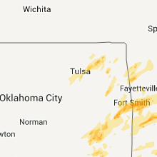
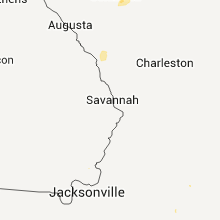
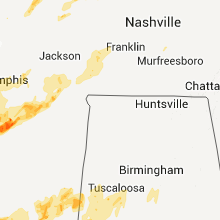
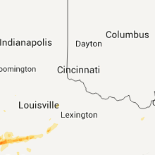
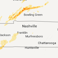
Hail Map for Tuesday, April 26, 2011

Number of Impacted Households on 4/26/2011
0
Impacted by 1" or Larger Hail
0
Impacted by 1.75" or Larger Hail
0
Impacted by 2.5" or Larger Hail
Square Miles of Populated Area Impacted on 4/26/2011
0
Impacted by 1" or Larger Hail
0
Impacted by 1.75" or Larger Hail
0
Impacted by 2.5" or Larger Hail


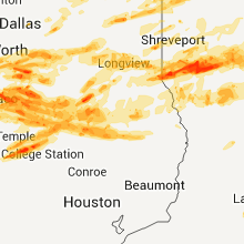


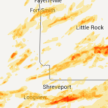


Cities Most Affected by Hail Storms of 4/26/2011
| Hail Size | Demographics of Zip Codes Affected | ||||||
|---|---|---|---|---|---|---|---|
| City | Count | Average | Largest | Pop Density | House Value | Income | Age |
| Waco, TX | 4 | 2.25 | 2.75 | 411 | $45k | $27.5k | 30.2 |
| Van Buren, AR | 3 | 2.92 | 4.25 | 320 | $72k | $33.0k | 36.2 |
| Mulberry, AR | 3 | 2.50 | 3.00 | 28 | $54k | $31.2k | 42.7 |
| Lock Haven, PA | 4 | 1.88 | 2.00 | 77 | $83k | $28.4k | 33.1 |
| Castor, LA | 3 | 2.50 | 3.00 | 17 | $43k | $24.2k | 37.4 |
| Hartford, KY | 3 | 2.08 | 2.75 | 50 | $58k | $27.1k | 39.9 |
| Benton, KY | 3 | 1.75 | 1.75 | 101 | $83k | $36.0k | 43.9 |
| Como, MS | 2 | 2.25 | 2.75 | 33 | $57k | $27.7k | 39.9 |
| Clarksdale, MS | 2 | 2.25 | 2.75 | 83 | $54k | $23.1k | 32.4 |
| Star City, AR | 2 | 1.88 | 2.00 | 26 | $53k | $31.0k | 39.1 |
| Coushatta, LA | 2 | 1.75 | 1.75 | 24 | $49k | $23.4k | 38.5 |
| Jewett, TX | 2 | 1.75 | 1.75 | 10 | $64k | $34.5k | 41.3 |
| Sacramento, KY | 2 | 1.75 | 1.75 | 46 | $53k | $28.8k | 42.0 |
| Palestine, AR | 2 | 1.75 | 1.75 | 13 | $49k | $25.8k | 42.8 |
| Elm Grove, LA | 2 | 1.75 | 1.75 | 26 | $97k | $45.2k | 44.5 |
| Nortonville, KY | 2 | 1.75 | 1.75 | 41 | $45k | $27.9k | 39.4 |
| Gould, AR | 2 | 1.75 | 1.75 | 5 | $45k | $23.0k | 45.3 |
| Madisonville, KY | 2 | 1.75 | 1.75 | 161 | $63k | $32.1k | 40.2 |
| Lindale, TX | 1 | 3.00 | 3.00 | 126 | $91k | $39.6k | 40.4 |
| Sparkman, AR | 1 | 2.75 | 2.75 | 6 | $39k | $27.9k | 46.2 |
| Fort Smith, AR | 1 | 2.50 | 2.50 | 2534 | $58k | $26.6k | 34.6 |
| Gilbertsville, KY | 1 | 2.00 | 2.00 | 171 | $108k | $39.1k | 49.3 |
| Newburgh, IN | 1 | 2.00 | 2.00 | 761 | $128k | $60.3k | 39.1 |
| Byron Center, MI | 1 | 2.00 | 2.00 | 395 | $154k | $57.6k | 39.1 |
| Grady, AR | 1 | 2.00 | 2.00 | 4 | $36k | $25.9k | 35.6 |
| Scotts Hill, TN | 1 | 2.00 | 2.00 | 45 | $59k | $31.6k | 41.6 |
| Brownsville, KY | 1 | 1.75 | 1.75 | 25 | $58k | $22.7k | 42.0 |
| Taberg, NY | 1 | 1.75 | 1.75 | 33 | $74k | $36.6k | 39.6 |
| Boonville, IN | 1 | 1.75 | 1.75 | 114 | $77k | $39.8k | 42.3 |
| Blossom, TX | 1 | 1.75 | 1.75 | 35 | $44k | $31.6k | 40.8 |
| Franklin, LA | 1 | 1.75 | 1.75 | 88 | $69k | $25.7k | 39.2 |
| Arlington, TN | 1 | 1.75 | 1.75 | 334 | $155k | $57.2k | 35.6 |
| Byhalia, MS | 1 | 1.75 | 1.75 | 88 | $81k | $33.6k | 39.9 |
| Syracuse, NY | 1 | 1.75 | 1.75 | 4822 | $78k | $19.4k | 21.9 |
| Tahlequah, OK | 1 | 1.75 | 1.75 | 105 | $68k | $25.4k | 30.6 |
| Huntingburg, IN | 1 | 1.75 | 1.75 | 120 | $82k | $39.1k | 38.8 |
| Groveton, TX | 1 | 1.75 | 1.75 | 6 | $43k | $21.9k | 42.5 |
| Fordsville, KY | 1 | 1.75 | 1.75 | 26 | $41k | $25.5k | 43.6 |
| Waxahachie, TX | 1 | 1.75 | 1.75 | 87 | $106k | $60.6k | 37.0 |
| Calvert City, KY | 1 | 1.75 | 1.75 | 125 | $76k | $37.4k | 44.1 |
| Blooming Grove, TX | 1 | 1.75 | 1.75 | 30 | $59k | $39.9k | 38.6 |
| Perryville, AR | 1 | 1.75 | 1.75 | 15 | $59k | $30.4k | 43.2 |
| Ledbetter, KY | 1 | 1.75 | 1.75 | 134 | $62k | $35.9k | 40.7 |
| Dukedom, TN | 1 | 1.75 | 1.75 | 14 | $42k | $26.7k | 44.7 |
| Clinton, AR | 1 | 1.75 | 1.75 | 22 | $61k | $24.7k | 44.4 |
| Prescott, AR | 1 | 1.75 | 1.75 | 23 | $45k | $28.0k | 41.0 |
| Blossvale, NY | 1 | 1.75 | 1.75 | 86 | $74k | $37.9k | 41.0 |
| Forrest City, AR | 1 | 1.75 | 1.75 | 100 | $60k | $26.6k | 35.8 |
| Judsonia, AR | 1 | 1.75 | 1.75 | 75 | $55k | $28.9k | 39.1 |
| Paris, TX | 1 | 1.75 | 1.75 | 266 | $47k | $26.2k | 36.7 |
| Camillus, NY | 1 | 1.75 | 1.75 | 654 | $95k | $50.9k | 44.4 |
| Dawson Springs, KY | 1 | 1.75 | 1.75 | 52 | $47k | $24.9k | 42.2 |
| Daingerfield, TX | 1 | 1.75 | 1.75 | 60 | $44k | $32.6k | 43.8 |
| Roxton, TX | 1 | 1.75 | 1.75 | 4 | $35k | $26.4k | 41.9 |
| Liverpool, NY | 1 | 1.75 | 1.75 | 2813 | $82k | $43.2k | 43.0 |
| Talihina, OK | 1 | 1.75 | 1.75 | 7 | $45k | $24.9k | 43.8 |
| Frost, TX | 1 | 1.75 | 1.75 | 16 | $40k | $31.9k | 40.8 |
| Elm Mott, TX | 1 | 1.75 | 1.75 | 80 | $58k | $38.7k | 41.6 |
| De Witt, AR | 1 | 1.75 | 1.75 | 21 | $50k | $25.4k | 40.5 |
| Ennis, TX | 1 | 1.75 | 1.75 | 104 | $73k | $41.1k | 33.7 |
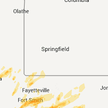
| Springfield, AR | 1 | 1.75 | 1.75 | 27 | $44k | $33.0k | 41.5 |
| Rusk, TX | 1 | 1.75 | 1.75 | 33 | $55k | $29.4k | 39.2 |
| Norris City, IL | 1 | 1.75 | 1.75 | 23 | $40k | $29.0k | 43.5 |
| Riceville, TN | 1 | 1.75 | 1.75 | 77 | $95k | $34.7k | 42.7 |
| Marquez, TX | 1 | 1.75 | 1.75 | 11 | $53k | $34.2k | 45.3 |
| West, TX | 1 | 1.75 | 1.75 | 62 | $62k | $38.3k | 40.6 |
| Alma, AR | 1 | 1.75 | 1.75 | 144 | $81k | $33.9k | 36.7 |
| Cleburne, TX | 1 | 1.75 | 1.75 | 156 | $0k | $0.0k | 36.8 |
| Helena, AR | 1 | 1.75 | 1.75 | 63 | $50k | $19.9k | 37.0 |
| Pine Bluff, AR | 1 | 1.75 | 1.75 | 196 | $64k | $35.5k | 39.4 |
| Gloster, LA | 1 | 1.75 | 1.75 | 35 | $79k | $35.6k | 37.2 |
| Lovelady, TX | 1 | 1.75 | 1.75 | 7 | $53k | $32.2k | 42.4 |
| Gentry, AR | 1 | 1.75 | 1.75 | 66 | $78k | $34.2k | 35.5 |
| Princeton, KY | 1 | 1.75 | 1.75 | 43 | $53k | $29.0k | 41.9 |
| Stonewall, LA | 1 | 1.75 | 1.75 | 122 | $90k | $40.0k | 39.7 |
| Muldrow, OK | 1 | 1.75 | 1.75 | 46 | $58k | $28.9k | 38.1 |
Hail and Wind Damage Spotted on 4/26/2011
Filter by Report Type:Hail ReportsWind Reports
States Impacted
Mississippi, Tennessee, Louisiana, Georgia, Pennsylvania, North Carolina, California, West Virginia, South Carolina, Oklahoma, New York, Kansas, Virginia, Texas, Arkansas, Kentucky, Indiana, Michigan, Missouri, Alabama, IllinoisMississippi
| Local Time | Report Details |
|---|---|
| 12:03 PM UTC | Major roof dmg to the roof of a house near w jones high school. many trees are down in this area as well. possible tornad in jones county MS, 66.1 miles SE of Jackson, MS |
| 12:20 PM UTC | Several trees down west of west jones high schoo in jones county MS, 74.2 miles ESE of Jackson, MS |
| 10:43 PM UTC | Quarter sized hail reported near Nesbit, MS, 19.4 miles S of Memphis, TN, quarter size hail at shelby drive and hwy 78 |
| 11:45 PM UTC | Multiple center pivots overturned in tunica county MS, 43.9 miles SSW of Memphis, TN |
| 11:58 PM UTC | Baseball sized hail reported near Clarksdale, MS, 70.8 miles SSW of Memphis, TN |
| 7:05 PM CDT | Golf Ball sized hail reported near Clarksdale, MS, 70.2 miles SSW of Memphis, TN |
| 12:45 AM UTC | Quarter sized hail reported near Coldwater, MS, 32.6 miles S of Memphis, TN, nickel to quarter size hail at hwy 51 |
| 12:45 AM UTC | Wind gusts to 65 mph. aluminum carports overturned in tate county MS, 31.9 miles S of Memphis, TN |
| 12:53 AM UTC | Golf Ball sized hail reported near Como, MS, 44.2 miles S of Memphis, TN |
| 1:10 AM UTC | Baseball sized hail reported near Como, MS, 44.5 miles S of Memphis, TN |
| 1:11 AM UTC | Quarter sized hail reported near Senatobia, MS, 36.8 miles S of Memphis, TN |
| 1:15 AM UTC | Golf Ball sized hail reported near Byhalia, MS, 39.1 miles SE of Memphis, TN |
| 2:21 AM UTC | Quarter sized hail reported near Ashland, MS, 54 miles ESE of Memphis, TN |
| 5:15 AM UTC | A few power lines dow in bolivar county MS, 89.9 miles NE of Bastrop, LA |
| 5:30 AM UTC | 4 homes with minor damage...1 church with minor damage and trees down across the county. time estimated in issaquena county MS, 51 miles E of Bastrop, LA |
| 5:43 AM UTC | A couple trees down...one across a r in washington county MS, 67.5 miles ENE of Bastrop, LA |
| 5:47 AM UTC | A few trees were blown down in sharkey county MS, 58.6 miles NW of Jackson, MS |
| 6:02 AM UTC | Several power poles down along with trees in the area...near the intersection of hwy 16 and 149...possible tornado in humphreys county MS, 50.2 miles NNW of Jackson, MS |
| 6:10 AM UTC | Numerous trees down across ridge road...roof blown off a house on the se side of yazoo city in yazoo county MS, 40.1 miles NNW of Jackson, MS |
| 6:25 AM UTC | Trees down across myrleville road. estimated gusts 65 mp in yazoo county MS, 30.4 miles N of Jackson, MS |
| 6:30 AM UTC | Trees down on 2 homes and 1 mobile home. power lines also down. time and location estimated in leflore county MS, 79.6 miles W of Starkville, MS |
| 6:31 AM UTC | Storm damage reported in carroll county MS, 73.2 miles W of Starkville, MS |
| 6:38 AM UTC | Several large trees down near highway 51 and highway 17 in picken in holmes county MS, 42.6 miles NNE of Jackson, MS |
| 6:40 AM UTC | 5 homes with minor damage...1 vacant building destroyed...3 barns with major damage...numerous trees down. damage scattered around the count in carroll county MS, 64 miles W of Starkville, MS |
| 6:41 AM UTC | Quarter sized hail reported near Canton, MS, 27.7 miles NNE of Jackson, MS |
| 6:45 AM UTC | A tree fell on two houses and a second tree fell on a house in sido in leflore county MS, 76.6 miles N of Jackson, MS |
| 7:00 AM UTC | Power outages around town due to two blown substations and numerous downed tree in grenada county MS, 70.3 miles WNW of Starkville, MS |
| 7:00 AM UTC | Possible tornado on county rd 9. one mobile home destroyed due to trees falling on home. lots of trees twiste in yalobusha county MS, 71.9 miles WNW of Starkville, MS |
| 7:08 AM UTC | Multiple reports of trees and powerlines down in the city of grenad in grenada county MS, 61.4 miles WNW of Starkville, MS |
| 7:13 AM UTC | Ping Pong Ball sized hail reported near Yazoo City, MS, 40.9 miles NNW of Jackson, MS, ping pong ball sized hail reported near highway 49 and highway 16 |
| 7:20 AM UTC | Power outages and numerous trees down around the city in grenada county MS, 61.4 miles WNW of Starkville, MS |
| 7:20 AM UTC | Trees and powerlines down in poplar creek...at least 10 homes heavily damaged between hwy 407 and 413. possible tornad in montgomery county MS, 43.9 miles W of Starkville, MS |
| 7:20 AM UTC | Trees and powerlines down in poplar creek in montgomery county MS, 43.9 miles W of Starkville, MS |
| 7:25 AM UTC | Numerous trees down across the county. many trees fell across roads and power lines. one tree fell on a house in flor in madison county MS, 18.9 miles NNW of Jackson, MS |
| 7:30 AM UTC | Damage that occurred west and north of oxford mississippi early april 27 2011 between approximately 230 am and 300 am cdt was determined to be straight line wind damage in lafayette county MS, 60.2 miles SSE of Memphis, TN |
| 7:30 AM UTC | Numerous trees and powerlines down across choctaw county...some on home in choctaw county MS, 21.5 miles WSW of Starkville, MS |
| 7:35 AM UTC | Numerous trees down in gore springs with structures damaged. possible tornad in grenada county MS, 50.5 miles WNW of Starkville, MS |
| 7:35 AM UTC | Trees down in at least ten locations across yazoo cit in yazoo county MS, 40.9 miles NNW of Jackson, MS |
| 7:38 AM UTC | Trees knocked down. emergency manager reports possible tornad in lafayette county MS, 61.9 miles SSE of Memphis, TN |
| 7:38 AM UTC | Trees knocked down in lafayette county MS, 61.9 miles SSE of Memphis, TN |
| 7:40 AM UTC | Several trees down in eastern grenada county near misterton in grenada county MS, 47.3 miles WNW of Starkville, MS |
| 7:44 AM UTC | Extensive damage reported in the southeast part of webster county. widespread trees and powerlines down...homes and businesses with damage. possible tornado in area bas in webster county MS, 19 miles WNW of Starkville, MS |
| 7:45 AM UTC | Large oak fell on a house in the hillcrest subdivision in hinds county MS, 9.2 miles WNW of Jackson, MS |
| 7:45 AM UTC | Several large trees were blown down along highway 9. one did minor damage to a home. possible tornad in webster county MS, 22.4 miles WNW of Starkville, MS |
| 7:54 AM UTC | Many trees and power lines down across the n portion of the count in winston county MS, 19.8 miles SSW of Starkville, MS |
| 7:56 AM UTC | A few power lines down along gallatin s in hinds county MS, 2.3 miles NW of Jackson, MS |
| 7:56 AM UTC | Trees down. one fell on a truck and person is now trapped in truc in clay county MS, 19.2 miles NNW of Starkville, MS |
| 7:58 AM UTC | Homes with damage. trees fell on house in union county MS, 66.6 miles SE of Memphis, TN |
| 8:00 AM UTC | Numerous trees down in raymond along with power outages in raymond...learned and utica in hinds county MS, 14.3 miles W of Jackson, MS |
| 8:05 AM UTC | Widespread mobile home damage along county road 190 near trebloc. possible tornad in chickasaw county MS, 24.6 miles N of Starkville, MS |
| 8:10 AM UTC | Several trees down in lee county MS, 53.4 miles N of Starkville, MS |
| 8:10 AM UTC | Around 10 houses with trees downed on them. locations include robinhood subvision...around monterey... richland...along highway 471 between brandon and highway 25...pea in rankin county MS, 10.6 miles E of Jackson, MS |
| 8:10 AM UTC | 3 businesses in carthage with roof damage...2 houses in the city with trees on them. power was out in the city for a short tim in leake county MS, 48.7 miles NE of Jackson, MS |
| 8:10 AM UTC | Numerous trees down in terry in hinds county MS, 15.4 miles SSW of Jackson, MS |
| 8:10 AM UTC | Trees down in at least ten locations across yazoo cit in yazoo county MS, 40.9 miles NNW of Jackson, MS |
| 8:10 AM UTC | A couple trees down along with many large limb in rankin county MS, 11 miles SSE of Jackson, MS |
| 8:10 AM UTC | Trees down on moor high road in oktibbeha county MS, 5.8 miles SE of Starkville, MS |
| 8:15 AM UTC | Multiple trees downs in pelahatchie in rankin county MS, 22.3 miles E of Jackson, MS |
| 8:17 AM UTC | Tree down on a car on highway 427 in leake county MS, 55.1 miles SSW of Starkville, MS |
| 8:17 AM UTC | *** 3 inj *** trees and powerlines down. 3 injuries reported in monroe county. possible tornado damag in monroe county MS, 36.8 miles NNE of Starkville, MS |
| 8:17 AM UTC | Trees and powerlines down. 3 injuries reported in monroe county. possible tornado damag in monroe county MS, 36.8 miles NNE of Starkville, MS |
| 8:17 AM UTC | Trees and power lines down along dora road. trees and power lines also down along highway 45 alternate just north of brooksvill in noxubee county MS, 20 miles SE of Starkville, MS |
| 8:20 AM UTC | Mobile home destroyed in the town of crawford. more information to follow. possible tornad in lowndes county MS, 16 miles SE of Starkville, MS |
| 8:24 AM UTC | Trees down around mortion with one on a hous in scott county MS, 30.7 miles E of Jackson, MS |
| 8:25 AM UTC | Power outages near downtown jackson...near the i55/i20 interchange...the stack...along highway 80 in jackso in hinds county MS, 2.3 miles NW of Jackson, MS |
| 8:29 AM UTC | Numerous trees and power lines down across the n portion of the count in scott county MS, 42.5 miles ENE of Jackson, MS |
| 8:29 AM UTC | A few trees down across the n portion of the count in neshoba county MS, 48.3 miles SSW of Starkville, MS |
| 8:35 AM UTC | A tree fell on a house in carthage. trees down countywide. power outages around the county als in leake county MS, 48.7 miles NE of Jackson, MS |
| 8:35 AM UTC | Roof off a chicken hous in neshoba county MS, 41.8 miles SSW of Starkville, MS |
| 8:35 AM UTC | Quarter sized hail reported near Philadelphia, MS, 45.2 miles SSW of Starkville, MS, nickel to quarter hail on highway 19n near arlington |
| 8:38 AM UTC | Trees down on polly bell road in webster county MS, 16.5 miles WNW of Starkville, MS |
| 8:38 AM UTC | Trees down on polly bell road in oktibbeha county MS, 15.7 miles WNW of Starkville, MS |
| 8:38 AM UTC | Many trees and power lines down across the n portion of the count in winston county MS, 19.8 miles SSW of Starkville, MS |
| 8:40 AM UTC | A tree fell on a transformer near 705 and 703 south of house in neshoba county MS, 60.6 miles S of Starkville, MS |
| 8:41 AM UTC | A few trees down...possible tornado based off rada in winston county MS, 33.5 miles SSW of Starkville, MS |
| 8:44 AM UTC | Hwy 278 and hwy 8 intersection completely blocked by downed trees and power lin in monroe county MS, 41.2 miles NE of Starkville, MS |
| 8:45 AM UTC | 15-20 trees down in the area. also some damage to roofs. reported by ms band of choctaw emergency manager in newton county MS, 54.4 miles ENE of Jackson, MS |
| 8:45 AM UTC | Electricity out in philadelphia and northeast of dixon. tree down near range ave and bay street in neshoba county MS, 51 miles SSW of Starkville, MS |
| 8:45 AM UTC | Electricity out in philadelphia and northeast of dixon. tree down near range ave and bay street...update...a number of trees down across neshoba county in neshoba county MS, 51 miles SSW of Starkville, MS |
| 8:45 AM UTC | A tree fell on a transformer near 705 and 703 south of house in neshoba county MS, 60.6 miles S of Starkville, MS |
| 8:46 AM UTC | Large trees down. structure damage at 2nd street in belmont. old hwy 25 in belmont completely blocked. tree on vehicle trapping an individual. possible tornado damag in tishomingo county MS, 36.4 miles WSW of Florence, AL |
| 8:48 AM UTC | Homes damaged and one home destroyed in southern tishomingo county. possible tornado damag in tishomingo county MS, 36.4 miles WSW of Florence, AL |
| 8:49 AM UTC | Trees were knocked down. a barn and outdoor shed were damage in tishomingo county MS, 36.8 miles W of Florence, AL |
| 8:50 AM UTC | Trees and power lines down across hwy 356. power lines down in the glen and strickland communitie in alcorn county MS, 43.8 miles W of Florence, AL |
| 8:54 AM UTC | Trees and power lines down on little rock-decatur r in newton county MS, 66 miles E of Jackson, MS |
| 9:00 AM UTC | Trees and power lines down along dora road. trees and power lines also down along highway 45 alternate just north of brooksvill in noxubee county MS, 20 miles SE of Starkville, MS |
| 9:04 AM UTC | A large tree down on a hous in kemper county MS, 41.4 miles SSE of Starkville, MS |
| 9:10 AM UTC | Trees and power lines down across the county. time estimated in smith county MS, 42.9 miles ESE of Jackson, MS |
| 9:10 AM UTC | Trees down on highway 39 south of dekalb in kemper county MS, 51.5 miles S of Starkville, MS |
| 9:13 AM UTC | Minor damage to a house in kemper county MS, 47.9 miles SSE of Starkville, MS |
| 9:15 AM UTC | Quarter sized hail reported near Collinsville, MS, 67.4 miles S of Starkville, MS |
| 9:17 AM UTC | Roof blown off house in lauderdale county MS, 67.3 miles S of Starkville, MS |
| 9:21 AM UTC | Storm damage reported in lauderdale county MS, 64.1 miles S of Starkville, MS |
| 9:22 AM UTC | A few homes with shingle dmg in the porterville community...a few trees down as wel in kemper county MS, 57.3 miles SSE of Starkville, MS |
| 9:30 AM UTC | Three houses with roof damage. numerous trees down countywide in prentiss county MS, 51.8 miles W of Florence, AL |
| 9:32 AM UTC | Numerous trees down across the n half of the county...trees across rds...4 homes damaged due to trees. one vehicle ran into a downed tree which resulted in a few in in lauderdale county MS, 72.6 miles S of Starkville, MS |
Tennessee
| Local Time | Report Details |
|---|---|
| 12:17 PM UTC | Memphis international airport reported 58 mph gus in shelby county TN, 9 miles S of Memphis, TN |
| 8:25 PM UTC | Golf Ball sized hail reported near Dukedom, TN, 26.5 miles NNW of Mc Kenzie, TN, 3 miles east of dukedom along the ky/tn border |
| 11:03 PM UTC | Quarter sized hail reported near Bartlett, TN, 12.8 miles ENE of Memphis, TN, quarter size hail reported by public in downtown bartlett |
| 11:20 PM UTC | Quarter sized hail reported near Arlington, TN, 23.8 miles ENE of Memphis, TN, quarter hail reported at airline and wilson rd |
| 11:21 PM UTC | Half Dollar sized hail reported near Arlington, TN, 23.1 miles ENE of Memphis, TN, pea to half dollar size hail |
| 11:24 PM UTC | Quarter sized hail reported near Millington, TN, 17.5 miles NNE of Memphis, TN |
| 11:26 PM UTC | Ping Pong Ball sized hail reported near Atoka, TN, 22.7 miles NE of Memphis, TN |
| 11:28 PM UTC | Golf Ball sized hail reported near Arlington, TN, 23.8 miles ENE of Memphis, TN |
| 11:35 PM UTC | Ping Pong Ball sized hail reported near Drummonds, TN, 22.8 miles NNE of Memphis, TN |
| 11:45 PM UTC | A tree was down greater than 12 inches in diamete in shelby county TN, 15.2 miles ESE of Memphis, TN |
| 1:27 AM UTC | Trees were knocked down and a home suffered roof damage on hill house road near highway 138 near toone. possible tornad in hardeman county TN, 58.6 miles SSW of Mc Kenzie, TN |
| 2:04 AM UTC | Possible tornado in trailer park in jacks cree in chester county TN, 45.7 miles S of Mc Kenzie, TN |
| 2:09 AM UTC | Quarter sized hail reported near Jacks Creek, TN, 45.7 miles S of Mc Kenzie, TN, quarter sized hail with winds to 50 mph. |
| 2:15 AM UTC | Quarter sized hail reported near Atoka, TN, 26 miles NE of Memphis, TN |
| 2:20 AM UTC | Storm damage reported in henderson county TN, 42.6 miles SSE of Mc Kenzie, TN |
| 2:20 AM UTC | Hen Egg sized hail reported near Scotts Hill, TN, 42.6 miles SSE of Mc Kenzie, TN |
| 2:30 AM UTC | Power lines down and flooding on highway 205 south and raleigh lagrange roa in shelby county TN, 21.2 miles E of Memphis, TN |
| 3:50 AM UTC | Trained spotter rpts structural damage and trees down in linde in perry county TN, 52.5 miles SE of Mc Kenzie, TN |
| 3:57 AM UTC | Quarter sized hail reported near Linden, TN, 52.5 miles SE of Mc Kenzie, TN, trained spotter rpts hail of one inch diameter. |
| 7:00 AM UTC | Trees were reported down on highway 281 and highway 13 sout in humphreys county TN, 40.9 miles E of Mc Kenzie, TN |
| 8:21 AM UTC | Golf Ball sized hail reported near Riceville, TN, 41.4 miles NE of Chattanooga, TN |
| 9:30 AM UTC | Trees and power lines were reported downed across southern portions of the count in wayne county TN, 26.4 miles N of Florence, AL |
| 9:50 AM UTC | Numerous trees were blown down. poles and power lines were blown dow in lawrence county TN, 41.7 miles NNE of Florence, AL |
| 9:55 AM UTC | *** 1 inj *** approximately 30 houses da in lawrence county TN, 49.3 miles NNE of Florence, AL |
| 10:00 AM UTC | Multiple structures damaged and numerous trees blown down along highw in lawrence county TN, 28.1 miles NE of Florence, AL |
| 10:12 AM UTC | Bna asos measured 58 mph wind gust. altimeter spiked from 29.49 inches to 29.6 in davidson county TN, 0.2 miles NNW of Nashville, TN |
| 10:12 AM UTC | Sixty two mile an hour wind gust reported by a trained spotter in mount pleasan in maury county TN, 48.5 miles SSW of Nashville, TN |
| 10:21 AM UTC | Several homes with windows blown out in oak hill subdiv in wilson county TN, 14.7 miles ENE of Nashville, TN |
| 10:24 AM UTC | Tree on a house on william and earl road near mt. pleasant. other trees were blown down countywid in maury county TN, 40.7 miles SSW of Nashville, TN |
| 10:30 AM UTC | Boxwell. roof off main dining hall. possible tornad in wilson county TN, 20.8 miles ENE of Nashville, TN |
| 10:30 AM UTC | A tractor trailor pushed over by the wind along highway 43. in add in lawrence county TN, 26.1 miles NE of Florence, AL |
| 10:30 AM UTC | On moore road and caldwell in summertown a house destroyed and numerous houses with damage including trees as much as 3 ft in diameter on the in lawrence county TN, 44.9 miles NNE of Florence, AL |
| 10:43 AM UTC | Highway 41 at the rutherford/bedford county in rutherford county TN, 30.4 miles SSE of Nashville, TN |
| 10:45 AM UTC | Mobile home damage. trees and powerlines down. time estimated from radar. possible tornad in lincoln county TN, 61.8 miles ENE of Florence, AL |
| 10:45 AM UTC | Trees and powerlines dow in lincoln county TN, 61.8 miles ENE of Florence, AL |
| 10:45 AM UTC | Trees and power lines down mainly in unionville are in bedford county TN, 39.7 miles SSE of Nashville, TN |
| 10:45 AM UTC | Trees down near christiana on caro road and rock springs midland road. possible tornad in rutherford county TN, 36.7 miles SE of Nashville, TN |
| 10:54 AM UTC | Several trees down on st. andrews drive in rutherford county TN, 29.6 miles SE of Nashville, TN |
| 10:55 AM UTC | Mobile home damage. possible tornado damag in lincoln county TN, 61.8 miles ENE of Florence, AL |
| 10:56 AM UTC | Roof damage and siding damage to houses near haynes drive...possible tornado in rutherford county TN, 29.4 miles SE of Nashville, TN |
| 10:57 AM UTC | Damage in the jamison place subdivision. shingles off homes...trees topped and fences blown down in rutherford county TN, 30.9 miles SE of Nashville, TN |
| 10:57 AM UTC | Regent wood area. trees down. powerpole damage. roof damage. possible tornad in rutherford county TN, 29.4 miles SE of Nashville, TN |
| 10:57 AM UTC | Trees were blown down. spotter measured 74 mph wind with home weather statio in rutherford county TN, 28.5 miles SE of Nashville, TN |
| 10:58 AM UTC | Over one hundred trees down in trotter lane in murfreesboro. roads partially blocked. minimum to medium roof damage to homes and outbuildings destroye in rutherford county TN, 30.9 miles SE of Nashville, TN |
| 10:58 AM UTC | Update to previous report...minor roof damage and structural damage to 5 h in rutherford county TN, 31.3 miles SSE of Nashville, TN |
| 11:00 AM UTC | D in rutherford county TN, 30.9 miles SE of Nashville, TN |
| 11:00 AM UTC | Homes damaged and trees blown down in the bethpage are in sumner county TN, 33 miles NE of Nashville, TN |
| 11:05 AM UTC | Large tree down on kingwood drive. large limbs and lines down as wel in rutherford county TN, 30.9 miles SE of Nashville, TN |
| 11:05 AM UTC | A tree was blown down on a house on lois ridge roa in moore county TN, 61 miles WNW of Chattanooga, TN |
| 11:05 AM UTC | Tree down on house along lois ridge roa in moore county TN, 61 miles WNW of Chattanooga, TN |
| 11:07 AM UTC | Several trailers overturned with numerous trees down along highway 41a. church roof blown off near carr creek road and motlow college road. possible tornado. time estim in moore county TN, 59.5 miles SSE of Nashville, TN |
| 11:08 AM UTC | Trees and powerlines dow in lincoln county TN, 61.8 miles ENE of Florence, AL |
| 11:10 AM UTC | Highway 267 roofs da in wilson county TN, 37.9 miles E of Nashville, TN |
| 11:16 AM UTC | Trees down on middleton and bluebird road in wilson county TN, 36 miles E of Nashville, TN |
| 11:18 AM UTC | Trained spotter reports a tree down near alexandri in dekalb county TN, 55.5 miles ESE of Nashville, TN |
| 11:18 AM UTC | Heavy damage to power poles and line in wilson county TN, 38.2 miles E of Nashville, TN |
| 11:18 AM UTC | Between alexandria and watertown numerous trees in wilson county TN, 40.5 miles E of Nashville, TN |
| 11:20 AM UTC | Trees were blown down. a spotter measured an 82 mph gust before his home wind equipment was destroye in de kalb county TN, 42.3 miles E of Nashville, TN |
| 11:30 AM UTC | House off foundation oak hall subdiviso in wilson county TN, 15.3 miles ENE of Nashville, TN |
| 11:30 AM UTC | Trees down along both rock road and new hope road off of highway 55 in summitville are in coffee county TN, 51.4 miles NW of Chattanooga, TN |
| 11:31 AM UTC | Spotter estimated a 70 mph wind gus in smith county TN, 47.3 miles E of Nashville, TN |
| 11:45 AM UTC | *** 4 inj *** one trailer destroyed at intersection of wheeler road and five-mile road in warren county TN, 51.4 miles NW of Chattanooga, TN |
| 11:46 AM UTC | Numerous trees were blown down. damage concentrated near viola in the southwest part of the count in warren county TN, 46.1 miles NW of Chattanooga, TN |
| 11:48 AM UTC | Trees reported blown dow in jackson county TN, 64.4 miles ENE of Nashville, TN |
| 11:49 AM UTC | Numerous trees reportedly blown down. trained spotter also reported wind gusts estimated at 60 mp in putnam county TN, 58.6 miles E of Nashville, TN |
Louisiana
| Local Time | Report Details |
|---|---|
| 1:15 PM UTC | Golf Ball sized hail reported near Franklin, LA, 34.4 miles SSE of Lafayette, LA, several public reports of hail damage to camps...boats...and vehicles. camps sustained broken windows and siding damage. vehicles and boats were dented and had windows |
| 12:35 AM UTC | Several trees down in the sweetwater subdivision near bento in bossier county LA, 12.1 miles N of Shreveport, LA |
| 1:08 AM UTC | Golf Ball sized hail reported near Stonewall, LA, 18.1 miles SSW of Shreveport, LA, hail reported just south of stonewall. |
| 1:20 AM UTC | Ping Pong Ball sized hail reported near Shreveport, LA, 6.7 miles SSW of Shreveport, LA, ping pong ball size hail off of norris ferry road extension |
| 1:27 AM UTC | Golf Ball sized hail reported near Elm Grove, LA, 12.7 miles SE of Shreveport, LA, golf ball size hail in taylortwon |
| 1:27 AM UTC | Large tree branches down. winds estimated near 60 mp in bossier county LA, 12.7 miles SE of Shreveport, LA |
| 1:27 AM UTC | *** 4 inj *** possible tornado along atkins clark rd. oil rig knocked over with several minor injuries. numerous trees knocked over blocking emergency vehicle access in bossier county LA, 19.7 miles SE of Shreveport, LA |
| 1:30 AM UTC | Estimated wind gust to 65 mph at lock and dam in bossier county LA, 22.5 miles SE of Shreveport, LA |
| 8:30 PM CDT | Golf Ball sized hail reported near Elm Grove, LA, 22.5 miles SE of Shreveport, LA, golf ball size hail at lock and dam 5 |
| 1:37 AM UTC | Trees and power lines down onto cars near lake bistinea in bienville county LA, 22.6 miles ESE of Shreveport, LA |
| 8:42 PM CDT | Quarter sized hail reported near Ringgold, LA, 30.1 miles ESE of Shreveport, LA, power outages and quarter sized hail near bisteneau |
| 8:42 PM CDT | Golf Ball sized hail reported near Coushatta, LA, 30.1 miles SE of Shreveport, LA, golf ball size hail in the east point community west of hall summit. |
| 1:45 AM UTC | Numerous trees down on homes and car in bienville county LA, 30.1 miles ESE of Shreveport, LA |
| 8:47 PM CDT | Quarter sized hail reported near Hall Summit, LA, 34.9 miles SE of Shreveport, LA |
| 1:52 AM UTC | Trees and power lines down in jamestow in bienville county LA, 33.6 miles ESE of Shreveport, LA |
| 9:00 PM CDT | Baseball sized hail reported near Castor, LA, 38.7 miles ESE of Shreveport, LA, baseball size hail falling just south of castor on highway 153. |
| 2:00 AM UTC | Tea Cup sized hail reported near Castor, LA, 39 miles ESE of Shreveport, LA, while falling at a forty five degree angle for thirty minutes...hail caused structural damage and stripped trees of foliage. |
| 9:11 PM CDT | Golf Ball sized hail reported near Lucky, LA, 46.5 miles ESE of Shreveport, LA, golf ball size hail near the saline community. |
| 2:25 AM UTC | Numerous trees were blown down on domino road northeast of liberty hill...about a mile southwest of highway 147 north of the mount olive communit in bienville county LA, 54.5 miles E of Shreveport, LA |
| 2:38 AM UTC | Possible tornado. law enforcement reports widespread trees down in southwest corner of parish. widespred limbs and other debris noted at intersection of highways 167 an in lincoln county LA, 46.7 miles WSW of Bastrop, LA |
| 3:00 AM UTC | Numerous trees down along highway 144 between calhoun and eros in the extreme western portions of ouachita parish. possible tornad in ouachita county LA, 35 miles SW of Bastrop, LA |
| 3:24 AM UTC | Golf Ball sized hail reported near Gloster, LA, 21 miles S of Shreveport, LA, golfball hail falling at frierson road and i49 |
| 10:30 PM CDT | Quarter sized hail reported near Eros, LA, 32.7 miles SW of Bastrop, LA, quarter size hail on new natchitoches rd at highway 546. |
| 3:35 AM UTC | Several trees were downed across the parish including one down on a house in the heflin community. there were no report of injurie in webster county LA, 28.1 miles E of Shreveport, LA |
| 3:38 AM UTC | Numerous trees down along highway 594 about 4.5 miles north of interstate 20 in swartz. possible tornad in ouachita county LA, 15 miles SSW of Bastrop, LA |
| 3:40 AM UTC | Numerous trees down across the entire paris in bienville county LA, 46.1 miles ESE of Shreveport, LA |
| 3:44 AM UTC | Roof damaged at the academy sports store in west monroe. possible tornad in ouachita county LA, 23 miles SW of Bastrop, LA |
| 3:44 AM UTC | Morehouse parish so reporting lots of tree and powerline damage and possible tornado touchdown south and southwest of bastrop in morehouse county LA, 6.3 miles SSW of Bastrop, LA |
| 3:45 AM UTC | Numerous trees blown down in the garden district of monroe near the intersection of roselawn and 2nd street. shingles blown off of homes in the area as well. possible t in ouachita county LA, 20.8 miles SSW of Bastrop, LA |
| 3:45 AM UTC | Roof torn off a home at 596 whitewood road just north of west monro in ouachita county LA, 21.9 miles SW of Bastrop, LA |
| 3:54 AM UTC | Several trees downed across the entire paris in claiborne county LA, 44.3 miles ENE of Shreveport, LA |
| 3:55 AM UTC | Numerous trees and power lines down near hall summit. possible tornad in red river county LA, 34.9 miles SE of Shreveport, LA |
| 10:55 PM CDT | Golf Ball sized hail reported near Hall Summit, LA, 34.9 miles SE of Shreveport, LA, golf ball size hail in hall summit. |
| 4:15 AM UTC | Numerous trees were downed on highway 151 near calhoun cutoff road in calhoun. large branches were downed along highway 80 just east of calhou in ouachita county LA, 31.9 miles SW of Bastrop, LA |
| 4:28 AM UTC | Several trees down near bryan drive and good hope road in west monro in ouachita county LA, 23 miles SW of Bastrop, LA |
| 11:35 PM CDT | Quarter sized hail reported near Eros, LA, 32.7 miles SW of Bastrop, LA, quarter size hail near the intersection of highway 546 and new natchitoches road. |
| 4:35 AM UTC | Numerous trees are downed throughout the paris in jackson county LA, 59.4 miles SW of Bastrop, LA |
| 4:40 AM UTC | Numerous trees were downed on wall williams road...kenny lane...and t john road. other trees were downed on old darbonne road near kiroli park. possible tornad in ouachita county LA, 21.9 miles SW of Bastrop, LA |
| 4:50 AM UTC | Shutters torn off of a house on guyton swamp roa in ouachita county LA, 36.2 miles SW of Bastrop, LA |
| 5:05 AM UTC | Extensive tree and powerline damage across west carroll parish. trees down on some homes. most extensive damage is reported near the pioneer community where radar indic in west carroll county LA, 27.8 miles E of Bastrop, LA |
| 5:20 AM UTC | Trees and powerlines down parish wide. tree down on a house in lake providence. still getting report in east carroll county LA, 42.8 miles E of Bastrop, LA |
| 5:20 AM UTC | A tractor shed was destroyed and the fire station in the bowie community was heavily damaged. trees and power lines were down as well...possible tornad in east carroll county LA, 38.2 miles E of Bastrop, LA |
| 5:33 AM UTC | Tree down on a house in zwoll in sabine county LA, 60.6 miles S of Shreveport, LA |
| 5:40 AM UTC | Roof off of a home north of many at 390 brumley road. powerlines down at this location as well. possible tornad in sabine county LA, 63.8 miles SSE of Shreveport, LA |
| 5:42 AM UTC | Possible tornado. pine trees snapped and thrown through roof of house...with other trees uprooted. other widespread trees down and other debris noted near rocky springs in sabine county LA, 68.4 miles SSE of Shreveport, LA |
| 5:56 AM UTC | Possible tornado. reports of numerous power poles down near state highway 1 and lateral roa in natchitoches county LA, 66.1 miles SE of Shreveport, LA |
| 6:00 AM UTC | Strong downburst damage was found from near point place to bermuda. dozens of homes were damaged with numerous trees snapped and uprooted. many homes sustained roof dam in natchitoches county LA, 72.9 miles SE of Shreveport, LA |
| 6:00 AM UTC | Several trees were downed throughout the paris in natchitoches county LA, 64.4 miles SE of Shreveport, LA |
| 6:00 AM UTC | Numerous trees down near natchez. trees down through a roof of a home on highway 494 just southeast of natchez. possible tornad in natchitoches county LA, 72.4 miles SE of Shreveport, LA |
| 6:02 AM UTC | At the monroe regional airpor in ouachita county LA, 20.8 miles SSW of Bastrop, LA |
| 6:03 AM UTC | A strong downburst originating from severe thunderstorms near the bermuda community in natchitoches parish knocked over trees and damaged a few homes in montgomery. the in grant county LA, 77.4 miles SE of Shreveport, LA |
| 6:10 AM UTC | Multiple trees and power lines down...some on home in franklin county LA, 37 miles SSE of Bastrop, LA |
| 6:13 AM UTC | A home was severe damaged near nantachie creek on harrisonburg road. possible tornad in natchitoches county LA, 68 miles SE of Shreveport, LA |
| 6:13 AM UTC | A home was severely damaged near nantachie creek on harrisonburg road between black mountain road and the kimbrell cemetary just west of the wheeling community. numerou in natchitoches county LA, 68 miles SE of Shreveport, LA |
| 6:20 AM UTC | Possible tornado. winn parish sheriff reports numerous houses with roofs removed. trees covering portions of highway 34. one report of people trapped in house...emergen in winn county LA, 76.4 miles SE of Shreveport, LA |
| 6:25 AM UTC | Numerous trees downed and a barn destroyed. possible tornado in association with this stor in grant county LA, 81 miles SE of Shreveport, LA |
| 6:35 AM UTC | Possible tornado. numerous trees down and several homes reportedly destroye in la salle county LA, 70.4 miles SSW of Bastrop, LA |
| 6:50 AM UTC | Numerous trees and power lines down. some trees down on house in franklin county LA, 44.1 miles SSE of Bastrop, LA |
| 7:20 AM UTC | A few trees and power lines dow in tensas county LA, 62.8 miles SE of Bastrop, LA |
| 7:20 AM UTC | Multiple trees and power lines dow in franklin county LA, 57 miles SSE of Bastrop, LA |
| 7:30 AM UTC | Trees down in several locations around harrisonbur in catahoula county LA, 69.7 miles S of Bastrop, LA |
| 8:00 AM UTC | 2 mobile homes damaged in jonesvill in catahoula county LA, 80 miles S of Bastrop, LA |
| 10:55 AM UTC | Trees and power lines down in the area. trees and powerlines also down near tallulah near the same tim in madison county LA, 54.1 miles SE of Bastrop, LA |
Georgia
| Local Time | Report Details |
|---|---|
| 4:30 PM UTC | Power poles reported down on colonels island at the port of brunswic in glynn county GA, 53.5 miles N of Jacksonville, FL |
Pennsylvania
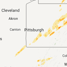
| Local Time | Report Details |
|---|---|
| 5:40 PM UTC | Multiple trees down in penn township in butler county PA, 23.9 miles N of Pittsburgh, PA |
| 7:36 PM UTC | Storm damage reported in cambria county PA, 60.6 miles WSW of State College, PA |
| 7:36 PM UTC | Kjst - john murtha cambria county airport in cambria county PA, 60.6 miles WSW of State College, PA |
| 7:40 PM UTC | Trees down on frankstown rd in cambria county PA, 57.3 miles E of Pittsburgh, PA |
| 7:53 PM UTC | Reports of trees down in cambria and croyle township in cambria county PA, 50.3 miles WSW of State College, PA |
| 7:53 PM UTC | Reports of trees down se of ebensburg in cambria and croyle township in cambria county PA, 50.3 miles WSW of State College, PA |
| 7:59 PM UTC | Trees down in washington county PA, 16.9 miles SSE of Pittsburgh, PA |
| 8:10 PM UTC | Trees down in fayette county PA, 29 miles SSE of Pittsburgh, PA |
| 8:30 PM UTC | Trees down in westmoreland county PA, 26 miles ESE of Pittsburgh, PA |
| 8:35 PM UTC | Latrobe airport in westmoreland county PA, 33.2 miles ESE of Pittsburgh, PA |
| 8:40 PM UTC | Quarter sized hail reported near Tyrone, PA, 21.9 miles WSW of State College, PA, quarter sized hail |
| 8:50 PM UTC | Quarter sized hail reported near Tyrone, PA, 21.9 miles WSW of State College, PA, quarter sized hail |
| 8:55 PM UTC | Trees down in westmoreland county PA, 42.3 miles ESE of Pittsburgh, PA |
| 9:04 PM UTC | Large branches down in indiana county PA, 44.7 miles E of Pittsburgh, PA |
| 9:25 PM UTC | Top of tree blown down in indiana county PA, 57.3 miles E of Pittsburgh, PA |
| 9:45 PM UTC | Trees down in susquehanna tw in cambria county PA, 49 miles W of State College, PA |
| 10:15 PM UTC | Hen Egg sized hail reported near Lock Haven, PA, 32.1 miles NE of State College, PA, silver dollar size hail |
| 10:15 PM UTC | Trees and wires down. woman trapped in car surrounded by live wires in clinton county PA, 32.1 miles NE of State College, PA |
| 10:20 PM UTC | Hen Egg sized hail reported near Lock Haven, PA, 32.1 miles NE of State College, PA, silver dollar size hail |
| 10:25 PM UTC | Quarter sized hail reported near Dunnstable, PA, 33.9 miles NE of State College, PA, cars damaged on rte 220 |
| 10:25 PM UTC | 6-8 large trees uprooted and power outages in clinton county PA, 37.1 miles NE of State College, PA |
| 10:35 PM UTC | Golf Ball sized hail reported near Lock Haven, PA, 32.1 miles NE of State College, PA, ground covered in hail |
| 10:50 PM UTC | Storm damage reported in blair county PA, 41.8 miles SW of State College, PA |
| 10:50 PM UTC | Golf Ball sized hail reported near Lock Haven, PA, 32.1 miles NE of State College, PA, numerous windows broken |
| 10:51 PM UTC | Trees and wires down. woman trapped in car surrounded by live wires in clinton county PA, 32.1 miles NE of State College, PA |
| 12:00 AM UTC | Widespread wind damage. silo blown over. barn and tractor trailer damage in mifflin county PA, 20.3 miles SE of State College, PA |
| 12:30 AM UTC | Trees down. power out in the town in union county PA, 43.4 miles ENE of State College, PA |
| 12:45 AM UTC | Multiple trees down blocking roadway at the intersection of state road 409 and 706 in bradford county PA, 36.8 miles NW of Scranton, PA |
| 12:53 AM UTC | Numerous trees down. 30 foot trailer overturned. pole barn destroye in susquehanna county PA, 26.5 miles NNW of Scranton, PA |
| 12:55 AM UTC | Trees down in montour county PA, 58.6 miles WSW of Scranton, PA |
| 1:05 AM UTC | Tree down on 21 south and fell on electical pole in susquehanna county PA, 38.9 miles N of Scranton, PA |
| 1:12 AM UTC | Trees down. power out in the town in union county PA, 43.4 miles ENE of State College, PA |
| 1:45 AM UTC | Quarter sized hail reported near Dimock, PA, 27.8 miles NNW of Scranton, PA |
| 1:56 AM UTC | Quarter sized hail reported near Swoyersville, PA, 13.3 miles SW of Scranton, PA, also... estimated 70 mph wind... numerous trees down with some falling on homes especially in the back mountain area. |
| 3:15 AM UTC | Structural damage and multiple trees down on mtn dr nr forest dr and n. mechanic st in lebanon county PA, 77.2 miles SSW of Scranton, PA |
| 3:55 AM UTC | Trees down scattered throughout the city in carbon county PA, 37.5 miles S of Scranton, PA |
| 4:35 AM UTC | Trees and power lines down in northampton county PA, 54.8 miles SSE of Scranton, PA |
| 4:35 AM UTC | Trees and power lines down in monroe county PA, 37.8 miles SE of Scranton, PA |
North Carolina
| Local Time | Report Details |
|---|---|
| 6:15 PM UTC | Car port blown over... minor structural damage to home... power lines down in martin county NC, 83.7 miles SW of Virginia Beach, VA |
| 8:35 PM UTC | Tree down along highway 64 west near lake park roa in randolph county NC, 60.5 miles NE of Charlotte, NC |
| 8:35 PM UTC | Tree down along ralph lawrence roa in randolph county NC, 60.6 miles NE of Charlotte, NC |
| 9:14 PM UTC | One tree blown down onto haystack roa in surry county NC, 73.7 miles E of Bristol, TN |
| 9:16 PM UTC | Several trees down on haystack road and one tree down on red hill creek roa in surry county NC, 75.5 miles SW of Roanoke, VA |
| 9:29 PM UTC | Trees on a house along maple grove church roa in surry county NC, 68 miles SW of Roanoke, VA |
| 10:33 PM UTC | Quarter sized hail reported near Dobson, NC, 72.8 miles SW of Roanoke, VA |
| 5:48 AM UTC | Tree down at intersection of graveyard rd and church rd off of hwy 7 in buncombe county NC, 48.8 miles NNE of Greenville, SC |
California
| Local Time | Report Details |
|---|---|
| 6:15 PM UTC | Quarter sized hail reported near Madera, CA, 24.4 miles NW of Fresno, CA |
West Virginia
| Local Time | Report Details |
|---|---|
| 6:58 PM UTC | Quarter sized hail reported near Middlebourne, WV, 68.4 miles NW of Elkins, WV |
| 7:21 PM UTC | Trees down in wileyville and also along route 20 in wetzel county WV, 65.8 miles NW of Elkins, WV |
| 8:07 PM UTC | Several tree limbs 6 to 8 inches in diameter down. penny size hail. 40 to 50 mph wind gust in lewis county WV, 34.6 miles WNW of Elkins, WV |
| 9:27 PM UTC | Trees down along tom cox road in dorcus area in grant county WV, 38.6 miles E of Elkins, WV |
| 10:48 PM UTC | Trees and power poles dow in mineral county WV, 56.8 miles NE of Elkins, WV |
| 12:03 AM UTC | Large oak tree down on synderville rd in hardy county WV, 44.6 miles ENE of Elkins, WV |
| 12:20 AM UTC | Quarter sized hail reported near Riverton, WV, 27.6 miles SE of Elkins, WV, nickel to quarter size hail |
| 12:28 AM UTC | Tree uprooted in grant county WV, 39.1 miles E of Elkins, WV |
| 12:30 AM UTC | Storm damage reported in grant county WV, 40.7 miles E of Elkins, WV |
| 12:30 AM UTC | Quarter sized hail reported near Petersburg, WV, 40.7 miles E of Elkins, WV |
| 12:37 AM UTC | Quarter sized hail reported near Moorefield, WV, 43.5 miles E of Elkins, WV, along jenkins run rd. |
| 12:46 AM UTC | Large limbs snapped off hardwood trees in hardy county WV, 48.5 miles E of Elkins, WV |
South Carolina
| Local Time | Report Details |
|---|---|
| 7:12 PM UTC | Quarter sized hail reported near Ulmer, SC, 48.8 miles ESE of Augusta, GA |
| 7:21 PM UTC | Quarter sized hail reported near Barnwell, SC, 45.5 miles ESE of Augusta, GA, public reported hail up to quarter size that nearly covered the ground. |
| 8:05 PM UTC | Quarter sized hail reported near Columbia, SC, 76 miles S of Charlotte, NC, quarter sized hail in ne columbia in the woodlands subdivision near two notch rd...clemson rd...and sparkleberry lane vicinity. |
| 8:25 PM UTC | 2 trees down...hwy 34 in kershaw county SC, 64.5 miles S of Charlotte, NC |
| 8:42 PM UTC | Tree was downed on hwy 97...taking out power lines in kershaw county SC, 56.3 miles S of Charlotte, NC |
| 8:54 PM UTC | Half Dollar sized hail reported near Heath Springs, SC, 46.8 miles S of Charlotte, NC, public reported half dollar size hail near stoneboro. |
Oklahoma
| Local Time | Report Details |
|---|---|
| 7:16 PM UTC | Quarter sized hail reported near Boswell, OK, 28.6 miles SSE of Atoka, OK, also very gusty...but no damage. |
| 9:20 PM UTC | Quarter sized hail reported near Wilburton, OK, 53.6 miles ENE of Atoka, OK, lots of penny size and some quarter size. |
| 9:40 PM UTC | Quarter sized hail reported near Hartshorne, OK, 32.3 miles NE of Atoka, OK, up to quarter size. |
| 10:25 PM UTC | Several large trees uprooted by the win in latimer county OK, 54.6 miles SW of Fort Smith, AR |
| 5:28 PM CDT | Golf Ball sized hail reported near Muldrow, OK, 12.9 miles WSW of Fort Smith, AR |
| 10:30 PM UTC | Half Dollar sized hail reported near Finley, OK, 36.7 miles E of Atoka, OK |
| 10:30 PM UTC | Trees blown down in spir in le flore county OK, 15 miles SW of Fort Smith, AR |
| 10:32 PM UTC | Quarter sized hail reported near Muldrow, OK, 10.2 miles W of Fort Smith, AR |
| 5:32 PM CDT | Golf Ball sized hail reported near Talihina, OK, 57.5 miles SW of Fort Smith, AR |
| 10:37 PM UTC | Storm damage reported in le flore county OK, 13.4 miles SW of Fort Smith, AR |
| 10:38 PM UTC | Quarter sized hail reported near Guymon, OK, 94.3 miles SSW of Garden City, KS |
| 10:45 PM UTC | Half Dollar sized hail reported near Hugo, OK, 42.5 miles SE of Atoka, OK |
| 10:48 PM UTC | Quarter sized hail reported near Goodwell, OK, 95.9 miles N of Amarillo, TX, quarter hail off highway 54 covering the ground |
| 10:52 PM UTC | Quarter sized hail reported near Tulsa, OK, 3.9 miles NNE of Tulsa, OK |
| 10:53 PM UTC | Quarter sized hail reported near Owasso, OK, 11.5 miles NE of Tulsa, OK |
| 11:05 PM UTC | Quarter sized hail reported near Guymon, OK, 94.3 miles SSW of Garden City, KS, with heavy rain |
| 11:33 PM UTC | Quarter sized hail reported near Chelsea, OK, 41.4 miles NE of Tulsa, OK |
| 6:36 PM CDT | Golf Ball sized hail reported near Tahlequah, OK, 48.1 miles NW of Fort Smith, AR |
| 11:45 PM UTC | Quarter sized hail reported near Afton, OK, 68.6 miles ENE of Tulsa, OK, time estimate from radar. location approximate.may have been just west of afton. |
| 11:52 PM UTC | Half Dollar sized hail reported near Fairland, OK, 72.3 miles SSE of Chanute, KS |
| 11:58 PM UTC | Quarter sized hail reported near Tahlequah, OK, 56.7 miles NNW of Fort Smith, AR |
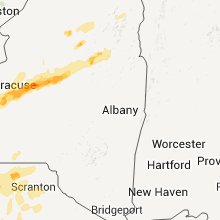
New York
| Local Time | Report Details |
|---|---|
| 7:21 PM UTC | Numerous trees dow in onondaga county NY, 10.9 miles WSW of Syracuse, NY |
| 7:30 PM UTC | Golf Ball sized hail reported near Syracuse, NY, 0.8 miles SSE of Syracuse, NY |
| 7:42 PM UTC | Half Dollar sized hail reported near Syracuse, NY, 0.8 miles SSE of Syracuse, NY |
| 7:45 PM UTC | Quarter sized hail reported near East Syracuse, NY, 4 miles E of Syracuse, NY |
| 7:49 PM UTC | Quarter sized hail reported near Manlius, NY, 9.1 miles E of Syracuse, NY |
| 8:02 PM UTC | Storm damage reported in madison county NY, 14 miles E of Syracuse, NY |
| 8:12 PM UTC | Near oneida lake...roof blown off and landed 1 mile away... 3 - 4 foot diameter trees snapped in madison county NY, 21.5 miles ENE of Syracuse, NY |
| 8:17 PM UTC | Golf Ball sized hail reported near Sylvan Beach, NY, 23.8 miles ENE of Syracuse, NY, trees and wires also reported down |
| 8:18 PM UTC | Roof blown off home in onondaga county NY, 10.9 miles NE of Syracuse, NY |
| 8:21 PM UTC | Half Dollar sized hail reported near Verona, NY, 29.2 miles E of Syracuse, NY |
| 8:25 PM UTC | Quarter sized hail reported near Annsville, NY, 29.7 miles ENE of Syracuse, NY |
| 8:27 PM UTC | Storm damage reported in oneida county NY, 35.5 miles ENE of Syracuse, NY |
| 8:29 PM UTC | Golf Ball sized hail reported near Lee, NY, 32.8 miles ENE of Syracuse, NY |
| 8:30 PM UTC | Dumpsters overturned in oneida county NY, 35.5 miles ENE of Syracuse, NY |
| 8:45 PM UTC | Quarter sized hail reported near Skaneateles, NY, 15.9 miles WSW of Syracuse, NY |
| 8:45 PM UTC | Ping Pong Ball sized hail reported near Camillus, NY, 8.3 miles W of Syracuse, NY |
| 8:45 PM UTC | Ping Pong Ball sized hail reported near Marcellus, NY, 10.9 miles WSW of Syracuse, NY |
| 8:46 PM UTC | Golf Ball sized hail reported near Camillus, NY, 8.3 miles W of Syracuse, NY, hail size varied from 1 inch to 1.75 inch |
| 8:55 PM UTC | Half Dollar sized hail reported near Camillus, NY, 5.2 miles W of Syracuse, NY, hail varied in size from quarter to half dollar |
| 8:58 PM UTC | Half Dollar sized hail reported near Liverpool, NY, 5.2 miles NW of Syracuse, NY |
| 9:00 PM UTC | Quarter sized hail reported near North Syracuse, NY, 5.6 miles N of Syracuse, NY, reported by weather observer at syracuse airportt |
| 9:00 PM UTC | Quarter sized hail reported near Solvay, NY, 3.2 miles WNW of Syracuse, NY |
| 9:00 PM UTC | Golf Ball sized hail reported near Liverpool, NY, 5.2 miles NW of Syracuse, NY |
| 9:00 PM UTC | Trees down and power out in onondaga county NY, 0.8 miles SSE of Syracuse, NY |
| 9:05 PM UTC | Quarter sized hail reported near Cicero, NY, 9.1 miles N of Syracuse, NY |
| 9:17 PM UTC | Power poles wires down in oswego county NY, 16.9 miles NNE of Syracuse, NY |
| 10:29 PM UTC | Quarter sized hail reported near Scio, NY, 69.1 miles SE of Buffalo, NY |
| 1:40 AM UTC | Many trees down in otsego county NY, 58.1 miles SE of Syracuse, NY |
Kansas
| Local Time | Report Details |
|---|---|
| 7:28 PM UTC | The elkhart amos station reported peak winds to 67 mph from 228 pm cdt to 248 pm cd in morton county KS, 87.1 miles SW of Garden City, KS |
Virginia
| Local Time | Report Details |
|---|---|
| 7:55 PM UTC | One tree blown down along highwa in halifax county VA, 60.6 miles N of Raleigh, NC |
| 8:20 PM UTC | One tree blown down along black walnut roa in halifax county VA, 73.2 miles ESE of Roanoke, VA |
| 9:07 PM UTC | A couple of trees were blown in carroll county VA, 56.1 miles SW of Roanoke, VA |
| 9:30 PM UTC | Quarter sized hail reported near Amherst, VA, 54.4 miles ENE of Roanoke, VA |
| 9:32 PM UTC | One tree down along highway 60w near burley hollow roa in amherst county VA, 51.4 miles ENE of Roanoke, VA |
| 9:38 PM UTC | Quarter sized hail reported near Roseland, VA, 58.2 miles NE of Roanoke, VA, hail penny to quarter size |
| 9:46 PM UTC | Quarter sized hail reported near Shawsville, VA, 18.4 miles WSW of Roanoke, VA |
| 10:50 PM UTC | Quarter sized hail reported near Gladys, VA, 48.7 miles E of Roanoke, VA, cocorahs observer. hail lasted 3 minutes. |
| 10:54 PM UTC | *** 1 inj *** pine tree down on automobile with one injury. tree down due to wind gus in city of charlottes county VA, 57.3 miles NW of Richmond, VA |
| 10:54 PM UTC | Tree fell and snapped power pole and brought power lines down in city of charlottes county VA, 58.1 miles NW of Richmond, VA |
| 10:55 PM UTC | Seven trees down along gladys in campbell county VA, 44.7 miles ESE of Roanoke, VA |
| 10:59 PM UTC | Quarter sized hail reported near Ferrum, VA, 28.7 miles SSW of Roanoke, VA |
| 11:01 PM UTC | Three trees blown along the 1000 to 2000 block of marshall mill roa in campbell county VA, 48.3 miles E of Roanoke, VA |
| 11:12 PM UTC | Three trees blown down along the 800 to 1000 block of poor house roa in campbell county VA, 46.4 miles E of Roanoke, VA |
| 11:21 PM UTC | Half Dollar sized hail reported near Amherst, VA, 60.3 miles ENE of Roanoke, VA, many nickels and quarters. largest half dollar. |
| 11:21 PM UTC | Half Dollar sized hail reported near Amherst, VA, 59.9 miles ENE of Roanoke, VA |
| 12:15 AM UTC | About 10 large oak trees blown down 1.5 miles east of route 53 and route 20 intersection. road closed for several hour in albemarle county VA, 55.1 miles NW of Richmond, VA |
Texas
| Local Time | Report Details |
|---|---|
| 8:06 PM UTC | Quarter sized hail reported near Matador, TX, 24.2 miles WSW of Childress, TX |
| 8:10 PM UTC | Quarter sized hail reported near Grandview, TX, 41.6 miles SSW of Dallas, TX, quarter size hail in grandview. |
| 3:39 PM CDT | Law enforcement reports 60 to 70 mph winds and quarter hail in waxahachie/forreston are in ellis county TX, 26.3 miles S of Dallas, TX |
| 3:40 PM CDT | Storm damage reported in ellis county TX, 35.5 miles S of Dallas, TX |
| 8:40 PM UTC | Quarter sized hail reported near Bardwell, TX, 35.5 miles S of Dallas, TX |
| 8:51 PM UTC | Quarter sized hail reported near Waxahachie, TX, 26.3 miles S of Dallas, TX, quarter size hail at hwy 287 bypass and hwy 878 in waxahachie. |
| 3:55 PM CDT | Golf Ball sized hail reported near Garrett, TX, 29.4 miles SSE of Dallas, TX |
| 3:57 PM CDT | Ping Pong Ball sized hail reported near Ennis, TX, 32.4 miles SSE of Dallas, TX, golfball size hail in the city of ennis. |
| 9:01 PM UTC | Quarter sized hail reported near Cameron, TX, 50.7 miles ESE of Killeen, TX, quarter size hail northeast of cameron. |
| 9:03 PM UTC | Storm damage to light shed structure with debris scattered over 100 yd in ellis county TX, 26.9 miles SSW of Dallas, TX |
| 4:05 PM CDT | Quarter sized hail reported near Ennis, TX, 32.4 miles SSE of Dallas, TX, wind gusts to 53 mph. |
| 9:20 PM UTC | Golf Ball sized hail reported near Cleburne, TX, 46 miles SW of Dallas, TX, golfball size hail just se of cleburne. |
| 9:27 PM UTC | Quarter sized hail reported near Grandview, TX, 39.6 miles SW of Dallas, TX, quarter size hail south of alvarado. |
| 9:35 PM UTC | Quarter sized hail reported near Jewett, TX, 84.7 miles W of Lufkin, TX, quarter hail reported southwest of the city of buffalo. |
| 4:39 PM CDT | Quarter sized hail reported near Alvarado, TX, 34.5 miles SSW of Dallas, TX, quarter size hail south of venus. |
| 9:43 PM UTC | Quarter sized hail reported near Midlothian, TX, 23.2 miles SSW of Dallas, TX |
| 9:43 PM UTC | Quarter sized hail reported near Palestine, TX, 59 miles WNW of Lufkin, TX, quarter size hail at fm84 and acr 385 se of palestine. |
| 4:47 PM CDT | Golf Ball sized hail reported near Waxahachie, TX, 27.4 miles SSW of Dallas, TX, golfball size hail just west of lone elm. |
| 4:51 PM CDT | Quarter sized hail reported near Hearne, TX, 68.8 miles ESE of Killeen, TX, hail covering the ground in hearne. biggest diameter quarter size. |
| 9:55 PM UTC | Golf Ball sized hail reported near Rusk, TX, 46.4 miles NW of Lufkin, TX, ham radio reporting golfball hail falling for 10 minutes south of jacksonville on fm 2138 |
| 9:59 PM UTC | Quarter sized hail reported near Waxahachie, TX, 26.3 miles S of Dallas, TX, quarter size hail 4 ne waxahachie |
| 10:05 PM UTC | Quarter sized hail reported near Gallatin, TX, 46.1 miles NNW of Lufkin, TX |
| 5:07 PM CDT | Quarter sized hail reported near Waxahachie, TX, 27.4 miles SSW of Dallas, TX, quarter size hail in lone elm west of waxahachie. |
| 5:11 PM CDT | Quarter sized hail reported near Waxahachie, TX, 23.5 miles S of Dallas, TX, quarter size hail north of waxahachie. |
| 10:16 PM UTC | Quarter sized hail reported near , , 57.1 miles SSW of Dallas, TX, quarter size hail north hillsboro |
| 10:16 PM UTC | Quarter sized hail reported near Franklin, TX, 81.3 miles E of Killeen, TX, quarter size hail falling in wheelock. |
| 5:26 PM CDT | Quarter sized hail reported near Sachse, TX, 19.1 miles NE of Dallas, TX |
| 5:28 PM CDT | Quarter sized hail reported near Italy, TX, 39.9 miles S of Dallas, TX |
| 10:35 PM UTC | Quarter sized hail reported near Wylie, TX, 21.9 miles NE of Dallas, TX, windshield damaged in wylie |
| 10:41 PM UTC | Golf Ball sized hail reported near Marquez, TX, 84.9 miles W of Lufkin, TX, golfball size hail reported at concord-robbins 39 & hwy 7 |
| 5:46 PM CDT | Golf Ball sized hail reported near Frost, TX, 48.1 miles S of Dallas, TX, golfball size hail reported in frost |
| 5:48 PM CDT | Golf Ball sized hail reported near Blooming Grove, TX, 46.9 miles S of Dallas, TX, golfball size hail 1 north of blooming grove |
| 11:10 PM UTC | Half Dollar sized hail reported near Cumby, TX, 60.6 miles ENE of Dallas, TX |
| 11:18 PM UTC | Trees & power lines on buildings and on ground on 314 between edom and van in van zandt county TX, 74.1 miles ESE of Dallas, TX |
| 11:20 PM UTC | Quarter sized hail reported near Tool, TX, 50.6 miles SE of Dallas, TX, quarter size hail reported in tool by public. |
| 6:28 PM CDT | Tea Cup sized hail reported near Lindale, TX, 80 miles ESE of Dallas, TX, 3.25 inch hail relayed from nws fwd |
| 11:33 PM UTC | Golf Ball sized hail reported near Waco, TX, 45.3 miles NE of Killeen, TX, mile marker 342 on interstate 35w north of waco. |
| 11:36 PM UTC | Baseball sized hail reported near Lacy-Lakeview, TX, 50.8 miles NE of Killeen, TX, baseball hail reported in lacy-lakeview by the public. |
| 11:42 PM UTC | Half Dollar sized hail reported near Cumby, TX, 60.6 miles ENE of Dallas, TX, half dollar size hail reported in cumby |
| 11:46 PM UTC | Golf Ball sized hail reported near Roxton, TX, 62 miles SSE of Atoka, OK |
| 11:50 PM UTC | Golf Ball sized hail reported near Paris, TX, 61.2 miles SE of Atoka, OK, golfball size hail west side of paris |
| 11:52 PM UTC | Golf Ball sized hail reported near Blossom, TX, 65.4 miles SE of Atoka, OK, golfball size hail reported in blossom |
| 11:55 PM UTC | Half Dollar sized hail reported near Mart, TX, 60.2 miles ENE of Killeen, TX |
| 11:55 PM UTC | Half Dollar sized hail reported near Paris, TX, 61.2 miles SE of Atoka, OK, half dollar size hail reported in the city of paris. |
| 11:57 PM UTC | Reported in eastern mclennan county in mclennan county TX, 45.3 miles NE of Killeen, TX |
| 12:05 AM UTC | Power lines down eastern mclennan & western limestone county in mclennan county TX, 58.8 miles NE of Killeen, TX |
| 7:40 PM CDT | Part of a roof blown off hwy 165 and hwy 14 in limestone county TX, 76.9 miles ENE of Killeen, TX |
| 1:30 AM UTC | Golf Ball sized hail reported near Elm Mott, TX, 53.7 miles NE of Killeen, TX |
| 1:31 AM UTC | Quarter sized hail reported near Leroy, TX, 59.4 miles NE of Killeen, TX |
| 8:31 PM CDT | Baseball sized hail reported near Waco, TX, 51.1 miles NE of Killeen, TX, reported near chalk bluff community |
| 1:36 AM UTC | Golf Ball sized hail reported near Leroy, TX, 59.4 miles NE of Killeen, TX |
| 1:42 AM UTC | Quarter sized hail reported near Red Oak, TX, 17.8 miles S of Dallas, TX |
| 1:45 AM UTC | Multiple trees down along west bound lanes of hwy 84 between lake mexia and fm 124 in limestone county TX, 77 miles S of Dallas, TX |
| 1:58 AM UTC | Golf Ball sized hail reported near Waco, TX, 45.3 miles NE of Killeen, TX |
| 2:18 AM UTC | Large tree down across 1 lane of hwy 84. tree diameter 2.5-3 ft in anderson county TX, 60.7 miles WNW of Lufkin, TX |
| 2:18 AM UTC | Very large mature tree uprooted and laying across 1 lane of hwy 84 in anderson county TX, 60.7 miles WNW of Lufkin, TX |
| 3:01 AM UTC | Quarter sized hail reported near Riesel, TX, 52.5 miles ENE of Killeen, TX, quarter hail 1 mile south of riesel on highway 6 |
| 3:05 AM UTC | Multiple trees down and on the roa in limestone county TX, 71.2 miles ENE of Killeen, TX |
| 4:35 AM UTC | Trees down in latexo on 153 in houston county TX, 44.6 miles W of Lufkin, TX |
| 4:44 AM UTC | Half Dollar sized hail reported near Centerville, TX, 74.9 miles W of Lufkin, TX |
| 4:45 AM UTC | Golf Ball sized hail reported near Jewett, TX, 79.6 miles W of Lufkin, TX, golfball hail 5 miles west of centerville |
| 4:45 AM UTC | Golf Ball sized hail reported near Jewett, TX, 80.8 miles W of Lufkin, TX, golfball hail 6 miles west of centerville |
| 4:46 AM UTC | Golf Ball sized hail reported near Lovelady, TX, 45.7 miles WSW of Lufkin, TX, brief period of golf ball hail in lovelady. public report to sheriffs office. |
| 5:13 AM UTC | Tree down on a house on mt. carmel road off of hwy 94 wes in angelina county TX, 4.9 miles W of Lufkin, TX |
| 5:15 AM UTC | Golf Ball sized hail reported near Groveton, TX, 31.2 miles SW of Lufkin, TX, hail fell in groveton reported by the public to dispatch. |
| 5:25 AM UTC | Numerous trees down along highway 21 near highway 103...as well as fm 330 and fm 1751 in sabine county TX, 47.4 miles E of Lufkin, TX |
| 10:00 AM UTC | Golf Ball sized hail reported near Daingerfield, TX, 66.6 miles NW of Shreveport, LA |
Arkansas
| Local Time | Report Details |
|---|---|
| 8:49 PM UTC | Golf Ball sized hail reported near Bluff City, AR, 44.1 miles ESE of Nashville, AR, golf ball size hail in bluff city. |
| 4:10 PM CDT | Baseball sized hail reported near Sparkman, AR, 57.3 miles E of Nashville, AR |
| 9:46 PM UTC | Quarter sized hail reported near Sheridan, AR, 31.2 miles SSW of Little Rock, AR |
| 9:46 PM UTC | Golf Ball sized hail reported near Gould, AR, 66.4 miles SE of Little Rock, AR, the report was from the mississippi state university storm chase team. |
| 9:59 PM UTC | Golf Ball sized hail reported near Palestine, AR, 49.8 miles WSW of Memphis, TN, emergency manager reports golf ball size hail near palestine |
| 9:59 PM UTC | Golf Ball sized hail reported near Star City, AR, 61 miles SSE of Little Rock, AR |
| 10:00 PM UTC | Quarter sized hail reported near North Little Rock, AR, 8.9 miles NNW of Little Rock, AR, hail began about 5 pm and lasted about 10 minutes. |
| 10:08 PM UTC | Golf Ball sized hail reported near Forrest City, AR, 43.1 miles WSW of Memphis, TN |
| 10:08 PM UTC | Golf Ball sized hail reported near Palestine, AR, 49.8 miles WSW of Memphis, TN |
| 10:09 PM UTC | Golf Ball sized hail reported near Gould, AR, 66.4 miles SE of Little Rock, AR |
| 10:10 PM UTC | Quarter sized hail reported near Pine Bluff, AR, 40.9 miles SSE of Little Rock, AR |
| 10:11 PM UTC | Hen Egg sized hail reported near Star City, AR, 61 miles SSE of Little Rock, AR |
| 10:18 PM UTC | Golf Ball sized hail reported near Pine Bluff, AR, 39.9 miles SSE of Little Rock, AR |
| 10:22 PM UTC | Golf Ball sized hail reported near Perryville, AR, 35.8 miles WNW of Little Rock, AR |
| 10:25 PM UTC | Quarter sized hail reported near Pine Bluff, AR, 48.8 miles SSE of Little Rock, AR |
| 10:25 PM UTC | Limbs were blown dow in jefferson county AR, 48.8 miles SSE of Little Rock, AR |
| 10:30 PM UTC | Tea Cup sized hail reported near Mulberry, AR, 27.2 miles ENE of Fort Smith, AR |
| 10:41 PM UTC | Golf Ball sized hail reported near Gentry, AR, 61 miles N of Fort Smith, AR |
| 10:43 PM UTC | Quarter sized hail reported near Gillett, AR, 64.6 miles SE of Little Rock, AR |
| 10:45 PM UTC | Golf Ball sized hail reported near De Witt, AR, 60.5 miles ESE of Little Rock, AR |
| 10:45 PM UTC | Hen Egg sized hail reported near Grady, AR, 57.5 miles SE of Little Rock, AR |
| 10:55 PM UTC | A few trees blown dow in ashley county AR, 24.7 miles NNW of Bastrop, LA |
| 10:55 PM UTC | Trees and power lines down along cr 2 near the state line. possible tornad in ashley county AR, 16.7 miles N of Bastrop, LA |
| 10:58 PM UTC | Golf Ball sized hail reported near Van Buren, AR, 5.5 miles NE of Fort Smith, AR |
| 11:00 PM UTC | Grapefruit sized hail reported near Van Buren, AR, 5.5 miles NE of Fort Smith, AR |
| 11:02 PM UTC | Golf Ball sized hail reported near Springfield, AR, 39.2 miles NNW of Little Rock, AR |
| 11:02 PM UTC | Baseball sized hail reported near Van Buren, AR, 5.5 miles NE of Fort Smith, AR |
| 11:08 PM UTC | Golf Ball sized hail reported near Alma, AR, 13.1 miles ENE of Fort Smith, AR |
| 11:10 PM UTC | Half Dollar sized hail reported near Lowell, AR, 63.7 miles NNE of Fort Smith, AR |
| 6:11 PM CDT | Tennis Ball sized hail reported near Fort Smith, AR, 1.3 miles ENE of Fort Smith, AR |
| 11:12 PM UTC | Quarter sized hail reported near Mulberry, AR, 22.4 miles ENE of Fort Smith, AR |
| 11:12 PM UTC | Quarter sized hail reported near Rudy, AR, 13.2 miles NE of Fort Smith, AR |
| 11:15 PM UTC | Two trucks overturn on i 40 in marion in crittenden county AR, 9.5 miles WNW of Memphis, TN |
| 11:15 PM UTC | The arkansas county sheriff reported a power line blown down at saint charles...causing outage in arkansas county AR, 70 miles ESE of Little Rock, AR |
| 11:15 PM UTC | Portion of roof off a hospital. other buildings damaged in area and county wid in crittenden county AR, 7.4 miles W of Memphis, TN |
| 11:15 PM UTC | Steel structure with roof twisted upward and wall down. many signs along i 40 broken off. ford dealership in west memphis has entire front of building destroye in crittenden county AR, 7.4 miles W of Memphis, TN |
| 11:15 PM UTC | Quarter sized hail reported near Rogers, AR, 67.3 miles NNE of Fort Smith, AR |
| 11:18 PM UTC | Golf Ball sized hail reported near Mulberry, AR, 22.4 miles ENE of Fort Smith, AR |
| 11:20 PM UTC | Ping Pong Ball sized hail reported near Dover, AR, 65.3 miles NW of Little Rock, AR |
| 11:21 PM UTC | Baseball sized hail reported near Mulberry, AR, 22.4 miles ENE of Fort Smith, AR |
| 11:23 PM UTC | Quarter sized hail reported near Enola, AR, 34.6 miles N of Little Rock, AR |
| 11:23 PM UTC | Quarter sized hail reported near Greenbrier, AR, 31.7 miles N of Little Rock, AR |
| 11:36 PM UTC | Quarter sized hail reported near Mansfield, AR, 24.4 miles SSE of Fort Smith, AR |
| 11:40 PM UTC | Quarter sized hail reported near Decatur, AR, 67.3 miles N of Fort Smith, AR |
| 11:44 PM UTC | Golf Ball sized hail reported near Helena, AR, 53 miles SW of Memphis, TN, golf ball size hail at helena bridge |
| 6:51 PM CDT | Spotter reporting 60 mph wind gust in texarkana in miller county AR, 35.7 miles SSW of Nashville, AR |
| 12:04 AM UTC | Golf Ball sized hail reported near Clinton, AR, 61.1 miles N of Little Rock, AR |
| 12:15 AM UTC | Portion of roof off a hospital. other buildings damaged in area and county wid in crittenden county AR, 7.4 miles W of Memphis, TN |
| 12:15 AM UTC | Steel structure with roof twisted upward and wall down. many signs along i 40 broken off. ford dealership in west memphis has entire front of building destroye in crittenden county AR, 7.4 miles W of Memphis, TN |
| 12:25 AM UTC | Tree across hwy 278 near hempstead nevada county line in nevada county AR, 26.6 miles ESE of Nashville, AR |
| 12:28 AM UTC | Tree on a vehicle on hwy 299 east of emmitt. possible injur in nevada county AR, 26.8 miles SE of Nashville, AR |
| 1:03 AM UTC | Golf Ball sized hail reported near Judsonia, AR, 53.4 miles NE of Little Rock, AR, the report was relayed by wfo memphis. |
| 2:12 AM UTC | Trees uprooted and powerlines downed. a few small sheds displaced and damage in sharp county AR, 96.5 miles NW of Memphis, TN |
| 2:12 AM UTC | *** 2 inj *** a house was leveled...with two occupants critically injure in sharp county AR, 95.7 miles NW of Memphis, TN |
| 2:30 AM UTC | Power lines were downed and a shed was damaged along judge anderson road. ditches were full of water due to heavy rai in sharp county AR, 96.1 miles S of Salem, MO |
| 2:35 AM UTC | Recorded at the south arkansas regional airport in union county AR, 58.7 miles WNW of Bastrop, LA |
| 2:53 AM UTC | Numerous trees down across highway 82 southeast of el dorado. possible tornad in union county AR, 48.1 miles NW of Bastrop, LA |
| 3:55 AM UTC | A few trees blown dow in ashley county AR, 24.7 miles NNW of Bastrop, LA |
| 3:55 AM UTC | Trees and power lines down along cr 2 near the state line. possible tornad in ashley county AR, 16.7 miles N of Bastrop, LA |
| 4:40 AM UTC | Two trees down in dermott in chicot county AR, 58.7 miles NNE of Bastrop, LA |
| 4:55 AM UTC | Numerous trees down. much of eudora without powe in chicot county AR, 44.8 miles ENE of Bastrop, LA |
| 5:10 AM UTC | Several trees and power lines dow in chicot county AR, 44.8 miles ENE of Bastrop, LA |
| 10:26 AM UTC | Quarter sized hail reported near Rosston, AR, 40.9 miles SE of Nashville, AR |
| 10:41 AM UTC | Half Dollar sized hail reported near Lewisville, AR, 41.6 miles SSE of Nashville, AR, hail reported along the east side of the river. |
| 11:07 AM UTC | Quarter sized hail reported near Rosston, AR, 42.2 miles SE of Nashville, AR, hail reported from a food store approximately 2 miles south of rosston along hwy. 371. |
Kentucky
| Local Time | Report Details |
|---|---|
| 9:16 PM UTC | Golf Ball sized hail reported near Princeton, KY, 62.1 miles SSW of Evansville, IN, hail up to golf ball size at mile marker 14 on west kentucky parkway |
| 9:47 PM UTC | Quarter sized hail reported near Providence, KY, 41.1 miles SSW of Evansville, IN, nickel to quarter size hail |
| 9:58 PM UTC | Quarter sized hail reported near Cadiz, KY, 64 miles NE of Mc Kenzie, TN, nickel to quarter size hail on canton road at eoc building |
| 10:00 PM UTC | Quarter sized hail reported near Owensboro, KY, 24.3 miles SE of Evansville, IN |
| 6:01 PM CDT | Baseball sized hail reported near Hartford, KY, 49 miles SE of Evansville, IN |
| 11:09 PM UTC | Golf Ball sized hail reported near Hartford, KY, 52.1 miles SE of Evansville, IN |
| 11:12 PM UTC | Golf Ball sized hail reported near Hartford, KY, 52.1 miles SE of Evansville, IN |
| 11:24 PM UTC | Golf Ball sized hail reported near Fordsville, KY, 51.7 miles ESE of Evansville, IN |
| 11:41 PM UTC | Quarter sized hail reported near Benton, KY, 50.2 miles N of Mc Kenzie, TN |
| 11:42 PM UTC | Quarter sized hail reported near Mayfield, KY, 39.1 miles N of Mc Kenzie, TN |
| 11:48 PM UTC | Half Dollar sized hail reported near Benton, KY, 56.5 miles N of Mc Kenzie, TN |
| 11:50 PM UTC | Golf Ball sized hail reported near Benton, KY, 54.1 miles NNE of Mc Kenzie, TN |
| 11:53 PM UTC | Golf Ball sized hail reported near Benton, KY, 56.5 miles N of Mc Kenzie, TN |
| 6:55 PM CDT | Quarter sized hail reported near Leitchfield, KY, 49.4 miles SW of Louisville, KY |
| 11:56 PM UTC | Quarter sized hail reported near Falls of Rough, KY, 52.4 miles SW of Louisville, KY |
| 12:05 AM UTC | Golf Ball sized hail reported near Calvert City, KY, 62.9 miles N of Mc Kenzie, TN |
| 12:07 AM UTC | Hen Egg sized hail reported near Gilbertsville, KY, 57.5 miles NNE of Mc Kenzie, TN, size was approaching tennis ball size |
| 12:10 AM UTC | Quarter sized hail reported near Mayfield, KY, 42.5 miles N of Mc Kenzie, TN |
| 12:10 AM UTC | Quarter sized hail reported near Wingo, KY, 37.1 miles NNW of Mc Kenzie, TN |
| 12:19 AM UTC | Possible tornado damage. a house and a barn were destroyed on the 2900 block of saint paul road. power lines were downe in grayson county KY, 39.8 miles SW of Louisville, KY |
| 12:22 AM UTC | Quarter sized hail reported near Benton, KY, 44.2 miles N of Mc Kenzie, TN |
| 12:25 AM UTC | Quarter sized hail reported near Symsonia, KY, 55 miles N of Mc Kenzie, TN |
| 12:31 AM UTC | Quarter sized hail reported near Calvert City, KY, 60.7 miles N of Mc Kenzie, TN |
| 12:36 AM UTC | Ping Pong Ball sized hail reported near Benton, KY, 57.8 miles N of Mc Kenzie, TN |
| 12:37 AM UTC | Golf Ball sized hail reported near Benton, KY, 50.7 miles NNE of Mc Kenzie, TN |
| 12:39 AM UTC | Quarter sized hail reported near Benton, KY, 50.2 miles N of Mc Kenzie, TN |
| 12:44 AM UTC | Quarter sized hail reported near Benton, KY, 51.5 miles NNE of Mc Kenzie, TN |
| 12:50 AM UTC | Golf Ball sized hail reported near Ledbetter, KY, 62.5 miles ESE of Cape Girardeau, MO |
| 12:50 AM UTC | Trees were downed across high stree in hardin county KY, 29 miles SSW of Louisville, KY |
| 1:33 AM UTC | Golf Ball sized hail reported near Nortonville, KY, 54.6 miles S of Evansville, IN, law enforcement officer spotted golf ball hail between dawson springs and nortonville ky |
| 1:35 AM UTC | Ping Pong Ball sized hail reported near Princeton, KY, 62.3 miles SSW of Evansville, IN |
| 1:37 AM UTC | Golf Ball sized hail reported near Nortonville, KY, 54.6 miles S of Evansville, IN |
| 1:50 AM UTC | Golf Ball sized hail reported near Dawson Springs, KY, 56.1 miles S of Evansville, IN |
| 2:10 AM UTC | Golf Ball sized hail reported near Madisonville, KY, 46.1 miles S of Evansville, IN, near the pennyrile pkwy exit 40 |
| 2:11 AM UTC | Golf Ball sized hail reported near Madisonville, KY, 44 miles S of Evansville, IN |
| 10:16 PM EDT | Half Dollar sized hail reported near Bardstown, KY, 18.6 miles SE of Louisville, KY |
| 9:35 PM CDT | Golf Ball sized hail reported near Sacramento, KY, 41.7 miles SSE of Evansville, IN, storm windows busted windshield cracked and a lot of dents in personal vehicle. |
| 9:37 PM CDT | Golf Ball sized hail reported near Sacramento, KY, 41.7 miles SSE of Evansville, IN |
| 10:08 PM CDT | Quarter sized hail reported near Livermore, KY, 41.1 miles SE of Evansville, IN |
| 3:14 AM UTC | Quarter sized hail reported near Utica, KY, 35.5 miles SE of Evansville, IN |
| 10:51 PM CDT | Golf Ball sized hail reported near Brownsville, KY, 59.2 miles SW of Louisville, KY |
| 11:26 PM CDT | Quarter sized hail reported near Cloverport, KY, 51.1 miles WSW of Louisville, KY |
| 4:28 AM UTC | Quarter sized hail reported near New Castle, KY, 44.1 miles NE of Louisville, KY |
| 4:29 AM UTC | Quarter sized hail reported near Falls of Rough, KY, 48.2 miles WSW of Louisville, KY |
| 11:26 AM UTC | Trees down near state lin in monroe county KY, 60.1 miles NE of Nashville, TN |
| 11:38 AM UTC | Trees down near centerpoint roa in monroe county KY, 70.9 miles ENE of Nashville, TN |
| 11:40 AM UTC | Roof was blown off a business. a 60 by 30 foot storage building was destroyed. a few barns were destroye in green county KY, 51.6 miles SSE of Louisville, KY |
| 11:59 AM UTC | Trees down across highway 7 in taylor county KY, 50.1 miles SSE of Louisville, KY |
| 11:59 AM UTC | Trees down and barns damaged in monroe county KY, 78.1 miles ENE of Nashville, TN |
Indiana
| Local Time | Report Details |
|---|---|
| 9:20 PM UTC | Quarter sized hail reported near La Porte, IN, 50.8 miles ESE of Chicago, IL, hail up to the size of quarters falling at this time. |
| 9:22 PM UTC | Quarter sized hail reported near La Porte, IN, 51.8 miles ESE of Chicago, IL |
| 10:32 PM UTC | Hen Egg sized hail reported near Newburgh, IN, 9.2 miles ESE of Evansville, IN, mostly quarter to a few 2 inch diameter hail stones which broke out a windshield on a car on outer lincoln avenue |
| 10:35 PM UTC | Quarter sized hail reported near Newburgh, IN, 9.2 miles ESE of Evansville, IN, two waves of quarter size hail in 5 minutes |
| 10:37 PM UTC | Quarter sized hail reported near Newburgh, IN, 9.2 miles ESE of Evansville, IN |
| 10:45 PM UTC | Ping Pong Ball sized hail reported near Boonville, IN, 16.5 miles ENE of Evansville, IN |
| 10:48 PM UTC | Golf Ball sized hail reported near Boonville, IN, 16.8 miles ENE of Evansville, IN, golfball size hail and a brief funnel cloud sighting |
| 10:52 PM UTC | Quarter sized hail reported near Boonville, IN, 16.8 miles ENE of Evansville, IN, quarter size hail covering the ground |
| 10:55 PM UTC | Quarter sized hail reported near Holland, IN, 34.2 miles ENE of Evansville, IN |
| 10:55 PM UTC | Golf Ball sized hail reported near Huntingburg, IN, 35.8 miles NE of Evansville, IN, in the zoar area north of holland. |
| 11:10 PM UTC | Quarter sized hail reported near St Anthony, IN, 46.5 miles ENE of Evansville, IN |
| 11:50 PM UTC | Quarter sized hail reported near Mitchell, IN, 65.2 miles NW of Louisville, KY |
Michigan
| Local Time | Report Details |
|---|---|
| 9:51 PM UTC | Quarter sized hail reported near Buchanan, MI, 65.8 miles E of Chicago, IL |
| 9:52 PM UTC | Quarter sized hail reported near Buchanan, MI, 65.8 miles E of Chicago, IL |
| 9:56 PM UTC | Half Dollar sized hail reported near Kentwood, MI, 6.2 miles SE of Grand Rapids, MI, hail at the intersection of kalamazoo avenue and m-6. |
| 9:56 PM UTC | Minor siding damage...small branches broken...small shed moved off its foundation in berrien county MI, 63.8 miles E of Chicago, IL |
| 10:00 PM UTC | Quarter sized hail reported near Buchanan, MI, 65.8 miles E of Chicago, IL, haiil up to size of quarters covered the ground but has ended. |
| 10:01 PM UTC | Quarter sized hail reported near Berrien, MI, 69.9 miles E of Chicago, IL, pea to dime size hail fell for 4 to 5 minutes. now 1.00 inch hail falling. |
| 10:05 PM UTC | Hen Egg sized hail reported near Byron, MI, 8.4 miles SSW of Grand Rapids, MI |
| 10:05 PM UTC | Hen Egg sized hail reported near , , 35.3 miles ESE of Grand Rapids, MI |
| 10:07 PM UTC | Quarter sized hail reported near East Grand Rapids, MI, 3.6 miles ESE of Grand Rapids, MI |
| 10:07 PM UTC | Quarter sized hail reported near Grand Rapids, MI, 3.6 miles SE of Grand Rapids, MI, delayed report. |
| 10:08 PM UTC | Quarter sized hail reported near Gaines, MI, 8.9 miles S of Grand Rapids, MI, delayed report. |
| 10:10 PM UTC | Quarter sized hail reported near Dowagiac, MI, 71.7 miles SSW of Grand Rapids, MI, 1.00 inch hail came in bursts. hail is covering the ground. |
| 10:25 PM UTC | Barn roof ripped off. reported by wzzm t in allegan county MI, 16.5 miles S of Grand Rapids, MI |
| 6:35 PM EDT | Half Dollar sized hail reported near Otisco, MI, 23.1 miles ENE of Grand Rapids, MI, delayed report. hail was observed on m-91 near fisk road. |
| 10:50 PM UTC | Ping Pong Ball sized hail reported near Sheridan, MI, 34.8 miles ENE of Grand Rapids, MI, the hail ranged in size from 1 inch up to an inch and a half. |
| 6:51 PM EDT | Ping Pong Ball sized hail reported near Belding, MI, 24.2 miles ENE of Grand Rapids, MI, large volume of inch and one half hail. no damage visible. |
| 10:57 PM UTC | Quarter sized hail reported near Evergreen, MI, 35.8 miles ENE of Grand Rapids, MI |
| 11:05 PM UTC | Half Dollar sized hail reported near Richland, MI, 41.5 miles SSE of Grand Rapids, MI |
| 11:06 PM UTC | Quarter sized hail reported near Kalamazoo, MI, 48.2 miles S of Grand Rapids, MI |
| 11:08 PM UTC | Quarter sized hail reported near Gaines, MI, 8.9 miles S of Grand Rapids, MI |
| 11:17 PM UTC | Quarter sized hail reported near Kentwood, MI, 6.9 miles SE of Grand Rapids, MI |
| 11:17 PM UTC | Half Dollar sized hail reported near Cascade, MI, 9.7 miles SE of Grand Rapids, MI, this fell at the nws office. |
| 11:20 PM UTC | Quarter sized hail reported near Cascade, MI, 9.9 miles E of Grand Rapids, MI |
| 12:07 AM UTC | Quarter sized hail reported near Mills, MI, 60.3 miles NNW of Flint, MI |
| 12:20 AM UTC | Quarter sized hail reported near Pinconning, MI, 60.5 miles NNW of Flint, MI |
| 12:49 AM UTC | Quarter sized hail reported near Au Gres, MI, 71.1 miles N of Flint, MI |
Missouri
| Local Time | Report Details |
|---|---|
| 11:06 PM UTC | Quarter sized hail reported near Noel, MO, 73.3 miles SW of Springfield, MO, nickel to quarter sized hail covering ground at u.s. 71 and missouri highway 90. |
Alabama
| Local Time | Report Details |
|---|---|
| 7:00 PM CDT | Quarter sized hail reported near Pelham, AL, 15.2 miles S of Birmingham, AL, quarter size hail reported at the intersection of industrial road and highway 31. |
| 12:14 AM UTC | Quarter sized hail reported near Gadsden, AL, 57.2 miles NE of Birmingham, AL, quarter size hail reported over the city of gadsden. |
| 9:05 AM UTC | Trees down on hwy 96 west of millpor in lamar county AL, 42.8 miles E of Starkville, MS |
| 9:06 AM UTC | Two trees were blown down at cherokee. possible tornado damag in colbert county AL, 17 miles W of Florence, AL |
| 9:20 AM UTC | Numerous trees reported across count in marion county AL, 45.3 miles SSW of Florence, AL |
| 9:26 AM UTC | Power outages and a wind gust to 70 mph was reporte in lauderdale county AL, 0.3 miles W of Florence, AL |
| 9:27 AM UTC | Trees and powerlines dow in lauderdale county AL, 22.6 miles WNW of Florence, AL |
| 9:30 AM UTC | Trees down on hwy 1 in sumter county AL, 58.2 miles SSE of Starkville, MS |
| 9:30 AM UTC | A tree and power line were blown down in ford cit in colbert county AL, 8.3 miles E of Florence, AL |
| 9:35 AM UTC | A wind gust to 70 mph was reported along with power outage in colbert county AL, 10.4 miles S of Florence, AL |
| 9:38 AM UTC | Trees down in carrollton on hwy 86 and hwy 8 in pickens county AL, 43.6 miles ESE of Starkville, MS |
| 9:38 AM UTC | Trees down on several houses in refor in pickens county AL, 46.2 miles E of Starkville, MS |
| 9:42 AM UTC | Trees down at the university in livingsto in sumter county AL, 67.2 miles NW of Camden, AL |
| 9:43 AM UTC | Trees down county wid in greene county AL, 56.5 miles ESE of Starkville, MS |
| 9:44 AM UTC | Trees down blocking hwy 17 near yor in sumter county AL, 68.7 miles WNW of Camden, AL |
| 9:49 AM UTC | Numerous trees down in tuscaloosa county AL, 57.1 miles WSW of Birmingham, AL |
| 9:50 AM UTC | Numerous trees and powerlines down in the ecm hospital are in lauderdale county AL, 0.3 miles W of Florence, AL |
| 9:54 AM UTC | Structure damage and numerous trees dow in tuscaloosa county AL, 46.1 miles W of Birmingham, AL |
| 9:55 AM UTC | A 60 mph gust was reported in lauderdale county AL, 22.1 miles ENE of Florence, AL |
| 10:00 AM UTC | Trees and powerlines downed. minor damage to one home on wolf creek roa in walker county AL, 40.2 miles WNW of Birmingham, AL |
| 10:02 AM UTC | Storm damage reported in tuscaloosa county AL, 46.3 miles WSW of Birmingham, AL |
| 10:02 AM UTC | One tree was blown down in the mount hope communit in lawrence county AL, 26 miles SSE of Florence, AL |
| 10:04 AM UTC | Reported on ua campu in tuscaloosa county AL, 46.3 miles WSW of Birmingham, AL |
| 10:05 AM UTC | Trees and powerlines down in and around moundville and akron in hale county AL, 59.4 miles SW of Birmingham, AL |
| 10:06 AM UTC | Trees and powerlines donw on homes. homes damaged or destroye in tuscaloosa county AL, 48.3 miles SW of Birmingham, AL |
| 10:06 AM UTC | Trees down on the university of alabama campu in tuscaloosa county AL, 46.3 miles WSW of Birmingham, AL |
| 10:07 AM UTC | Numerous trees down and structure damage including the elementary school. 30 to 40 structures damage. mainly roof damage. at lease 2 mobile homes destroyed. no injuries in fayette county AL, 47.1 miles WNW of Birmingham, AL |
| 10:07 AM UTC | Numerous trees down and structure damage including the elementary schoo in fayette county AL, 47.1 miles WNW of Birmingham, AL |
| 10:10 AM UTC | Minor damage to several hotels and stores at exit 45 along i-2 in greene county AL, 67.2 miles SE of Starkville, MS |
| 10:15 AM UTC | Trees down over roa in lauderdale county AL, 3.7 miles WNW of Florence, AL |
| 10:17 AM UTC | Several trees and power lines down and some on home in tuscaloosa county AL, 48.3 miles SW of Birmingham, AL |
| 10:17 AM UTC | Several trees down and some on home in tuscaloosa county AL, 48.3 miles SW of Birmingham, AL |
| 10:19 AM UTC | Trees down and debris in the roa in walker county AL, 41.5 miles WNW of Birmingham, AL |
| 10:21 AM UTC | Trees and powerlines down in hale county AL, 51.8 miles NNW of Camden, AL |
| 10:25 AM UTC | Numerous trees and structures damaged in the coaling area. at least 30 home da in tuscaloosa county AL, 39.4 miles SW of Birmingham, AL |
| 10:25 AM UTC | Numerous trees and structures damaged in the coaling are in tuscaloosa county AL, 39.4 miles SW of Birmingham, AL |
| 10:25 AM UTC | Trees and powerlines down on sr 86 at mile marker 15 and us 82 at mile marker 3 in pickens county AL, 53.3 miles ESE of Starkville, MS |
| 10:26 AM UTC | Numerous trees down and strucutre damage in jaspe in walker county AL, 34.8 miles NW of Birmingham, AL |
| 10:26 AM UTC | Numerous trees and large power poles snapped off around vance. interstate 20/59 was temporarily blocke in tuscaloosa county AL, 34.2 miles SW of Birmingham, AL |
| 10:28 AM UTC | Road signs blown down and a truck blown into the ditch along interstate 22 and exit 7 in walker county AL, 27.4 miles NW of Birmingham, AL |
| 10:31 AM UTC | Numerous trees down and roads closed in northern bibb. several strucutres also damage in tuscaloosa county AL, 29.3 miles SW of Birmingham, AL |
| 10:31 AM UTC | Tractor trailers overturned and trees uprooted near mile marker 93 on interstate 20/5 in tuscaloosa county AL, 27.4 miles SW of Birmingham, AL |
| 10:31 AM UTC | Tractor trailers overturned and trees uprooted near mile marker 93 on interstate 20/5 in talladega county AL, 42.5 miles ESE of Birmingham, AL |
| 10:35 AM UTC | Trees and power lines down on tinlge springs circle near exit 100 on interstate 20/5 in tuscaloosa county AL, 23.1 miles SW of Birmingham, AL |
| 10:35 AM UTC | Outbuildings damaged near sipse in walker county AL, 26.2 miles NW of Birmingham, AL |
| 10:38 AM UTC | Numerous trees down in the mccalla are in jefferson county AL, 16.9 miles SW of Birmingham, AL |
| 10:40 AM UTC | Two large broadcast radio towers reported down near the fairground in jefferson county AL, 4.6 miles W of Birmingham, AL |
| 10:40 AM UTC | Trees down on houses and blocking roadway in jefferson county AL, 12.2 miles WSW of Birmingham, AL |
| 10:40 AM UTC | Tree down on powerline on county road 61 near county road in lauderdale county AL, 12 miles NNE of Florence, AL |
| 10:40 AM UTC | Trees down at the intersection of county road 18 and county road 19 in shelby county AL, 30.3 miles S of Birmingham, AL |
| 10:40 AM UTC | Trees and powerlines down near shades crest road and bluff ridge roa in jefferson county AL, 19.3 miles SSW of Birmingham, AL |
| 10:45 AM UTC | Trees down across the campus of the university of montevall in shelby county AL, 28.4 miles S of Birmingham, AL |
| 10:46 AM UTC | Trees down on highway 261 in helen in shelby county AL, 16 miles S of Birmingham, AL |
| 10:49 AM UTC | Numerous trees down in vestavi in jefferson county AL, 6.3 miles S of Birmingham, AL |
| 10:49 AM UTC | Numerous trees down in vestavia. several homes and vehicles are damage in jefferson county AL, 6.3 miles S of Birmingham, AL |
| 10:50 AM UTC | A large tree on a home in pelha in shelby county AL, 15.2 miles S of Birmingham, AL |
| 10:50 AM UTC | A large tree on a home in pelham on trail ridge driv in shelby county AL, 15.2 miles S of Birmingham, AL |
| 10:51 AM UTC | Widespread trees and powerlines down across county including locations near brierfield along antio in bibb county AL, 33.6 miles S of Birmingham, AL |
| 10:53 AM UTC | Significant damage in the altadena lake area.. altadena lake dr at redwin in shelby county AL, 8.1 miles SSE of Birmingham, AL |
| 10:54 AM UTC | Marquee sign at the bjcc blown dow in jefferson county AL, 0.9 miles NE of Birmingham, AL |
| 10:54 AM UTC | Several trees snapped off and home roof damage in the brookhighland subdivision off highway 280. at least 100 homes with trees on them in the cahaba heights and vestavi in shelby county AL, 9 miles SE of Birmingham, AL |
| 10:54 AM UTC | Several trees snapped off and home roof damage in the brookhighland subdivision off highway 28 in shelby county AL, 9 miles SE of Birmingham, AL |
| 10:55 AM UTC | Tree down on house of a nws employe in jefferson county AL, 7.6 miles S of Birmingham, AL |
| 10:56 AM UTC | Numerous trees snapped and uprooted in cahaba heights in jefferson county AL, 6.3 miles ESE of Birmingham, AL |
| 10:58 AM UTC | Trees down across cit in jefferson county AL, 11.2 miles NE of Birmingham, AL |
| 10:58 AM UTC | Several trees down and structure damage in the hayden area on overlook poin in blount county AL, 27.8 miles N of Birmingham, AL |
| 10:58 AM UTC | Structural damage to house in the mountain woods lake communit in blount county AL, 23.5 miles N of Birmingham, AL |
| 11:00 AM UTC | 2nd avenue north is impassable due to downed trees in the roadwa in jefferson county AL, 0.9 miles NE of Birmingham, AL |
| 11:00 AM UTC | Roof torn off a large hangar at the birmingham shuttlesworth international airpor in jefferson county AL, 0.9 miles NE of Birmingham, AL |
| 11:00 AM UTC | Trees down on cr 1 in shelby county AL, 29.2 miles S of Birmingham, AL |
| 11:00 AM UTC | Tree down on a home near the intersection of interstate 20 and interstate 45 in jefferson county AL, 6 miles ENE of Birmingham, AL |
| 11:00 AM UTC | *** 1 fatal *** trees and power lines down across city. tree fell on house and caused one fatalit in jefferson county AL, 5.5 miles SE of Birmingham, AL |
| 11:00 AM UTC | Trees and power lines down on shady waters lan in jefferson county AL, 5.5 miles SE of Birmingham, AL |
| 11:02 AM UTC | Numerous trees down. trees down on hous in jefferson county AL, 14.7 miles E of Birmingham, AL |
| 11:02 AM UTC | Significant structural damage to new bethel church on hwy 411 in cherokee county AL, 66.5 miles SSW of Chattanooga, TN |
| 11:03 AM UTC | Numerous trees down and homes damage in blount county AL, 33.2 miles NNE of Birmingham, AL |
| 11:04 AM UTC | Trees reported down on homes. possible tornado damag in cullman county AL, 42.8 miles N of Birmingham, AL |
| 11:05 AM UTC | *** 1 fatal *** trees down on mobile home. one female fatalit in st. clair county AL, 21.6 miles ENE of Birmingham, AL |
| 11:08 AM UTC | Trees down near moody and damage to nursing home. over 100 mobile homes damage or destroye in st. clair county AL, 19.3 miles ENE of Birmingham, AL |
| 11:08 AM UTC | Trees down near moody and possible damage to some apartment in st. clair county AL, 19.3 miles ENE of Birmingham, AL |
| 11:08 AM UTC | Trees down near moody and possible damage to some apartments. numerous trees down and structures damage in st. clair county AL, 19.3 miles ENE of Birmingham, AL |
| 11:10 AM UTC | Trees were blown down at wallace state college. possible tornado damag in cullman county AL, 37.9 miles N of Birmingham, AL |
| 11:11 AM UTC | A 90 mph gust was reported. power was out at his location as wel in cullman county AL, 36.6 miles N of Birmingham, AL |
| 11:12 AM UTC | Numerous trees down and homes damage in blount county AL, 44.7 miles NNE of Birmingham, AL |
| 11:13 AM UTC | Several trees down and some structure damage near blountsvill in blount county AL, 42.1 miles NNE of Birmingham, AL |
| 11:14 AM UTC | Trees were blown dow in cullman county AL, 37.3 miles N of Birmingham, AL |
| 11:16 AM UTC | Trees down and damage to numerous homes on blair farm road and hickory lan in st. clair county AL, 26.5 miles ENE of Birmingham, AL |
| 11:18 AM UTC | Trees and power lines down on cedar creek roa in talladega county AL, 34.5 miles SE of Birmingham, AL |
| 11:18 AM UTC | Rv camper was blown onto the roa in cullman county AL, 46.1 miles NNE of Birmingham, AL |
| 11:18 AM UTC | Rv camper was blown onto the road. possible tornado damag in cullman county AL, 46.1 miles NNE of Birmingham, AL |
| 11:18 AM UTC | Two barns were blown down. possible tornado damag in cullman county AL, 46.1 miles NNE of Birmingham, AL |
| 11:20 AM UTC | Several trees down and possible strucutre damage in the are in blount county AL, 49.5 miles NNE of Birmingham, AL |
| 11:20 AM UTC | Trees and powerlines down. structure damage in the downtown are in st. clair county AL, 31.4 miles E of Birmingham, AL |
| 11:20 AM UTC | Trees and powerlines down. structure damage in the downtown area. comms tower at the eoc blown dow in st. clair county AL, 31.4 miles E of Birmingham, AL |
| 11:22 AM UTC | Trees and power lines down on cedar creek roa in talladega county AL, 34.5 miles SE of Birmingham, AL |
| 11:25 AM UTC | Trees down on homes along highway 231 south of arab. possible tornad in marshall county AL, 58 miles NNE of Birmingham, AL |
| 11:26 AM UTC | Structual damage on embry bend road in lincol in talladega county AL, 39.1 miles E of Birmingham, AL |
| 11:26 AM UTC | Trees down on hous in etowah county AL, 47.8 miles NE of Birmingham, AL |
| 11:30 AM UTC | Chicken houses were destroyed. possible tornado damag in marshall county AL, 58 miles NNE of Birmingham, AL |
| 11:30 AM UTC | Roof in st. clair county AL, 26.5 miles ENE of Birmingham, AL |
| 11:30 AM UTC | Trees down and rood damage to numerous home in st. clair county AL, 41.8 miles ENE of Birmingham, AL |
| 11:30 AM UTC | Several trees down along highway 69 between arab and guntersville. possible tornad in marshall county AL, 60.8 miles NNE of Birmingham, AL |
| 11:31 AM UTC | Numerous trees down across cit in talladega county AL, 41.6 miles E of Birmingham, AL |
| 11:33 AM UTC | Trees down blocking the roadway on jackson trace near broadwa in talladega county AL, 41.6 miles E of Birmingham, AL |
| 11:33 AM UTC | Trees and powerlines down on lancaster av in talladega county AL, 42.2 miles E of Birmingham, AL |
| 11:34 AM UTC | Powerlines were blown dow in marshall county AL, 58 miles NNE of Birmingham, AL |
| 11:40 AM UTC | Several trees down on highway 7 in calhoun county AL, 49 miles ENE of Birmingham, AL |
| 11:44 AM UTC | A few trees down in etowah count in etowah county AL, 57.2 miles NE of Birmingham, AL |
| 11:44 AM UTC | Phone lin blocking all four lanes of traffic on hwy 431 between hwy 144 and wellington r in calhoun county AL, 56.2 miles ENE of Birmingham, AL |
| 11:45 AM UTC | *** 2 inj *** tree fell on mobile home causing 2 minor injuries. numerous trees down county wide. trees on homes and business. estimated winds of 60 mp in etowah county AL, 59.1 miles ENE of Birmingham, AL |
| 11:45 AM UTC | Numerous trees were blown down. possible tornado damage. spotter heard loud roaring sound as damage occurre in marshall county AL, 67.8 miles NNE of Birmingham, AL |
| 11:45 AM UTC | Report of numerous trees blown down near the intersection of fry gap road and cr 14. one tree fell onto a car with two occupants. thankfully no injuries occurre in marshall county AL, 57.2 miles NNE of Birmingham, AL |
| 11:46 AM UTC | A few trees down in oxfor in calhoun county AL, 56.9 miles E of Birmingham, AL |
| 11:47 AM UTC | Large tree blown down on hwy 204 and thrown into yard several houses down the road in calhoun county AL, 60 miles ENE of Birmingham, AL |
| 11:50 AM UTC | Numerous trees down around the are in etowah county AL, 64 miles ENE of Birmingham, AL |
| 11:50 AM UTC | Structural damage along county road 50 near grove oak. possible tornado. time estimated from rada in dekalb county AL, 59.8 miles SW of Chattanooga, TN |
| 11:54 AM UTC | Reports of stuctural damage...numerous trees down...and powerlines down along a path from pisgah to flat rock near cr 120. one death occurred in the pisgah area. possib in jackson county AL, 39.8 miles SW of Chattanooga, TN |
| 11:54 AM UTC | Reports of stuctural damage...numerous trees down...and powerlines down along a path from pisgah to flat rock near cr 120. possible tornado damag in jackson county AL, 39.8 miles SW of Chattanooga, TN |
| 11:55 AM UTC | *** 1 inj *** home damaged on cr 6 in the gnatville communit in cherokee county AL, 73.3 miles ENE of Birmingham, AL |
| 11:55 AM UTC | Home damaged on cr 6 in the gnatville communit in cherokee county AL, 73.3 miles ENE of Birmingham, AL |
| 11:58 AM UTC | Tree on house on county road in cherokee county AL, 70.8 miles SSW of Chattanooga, TN |
Illinois
| Local Time | Report Details |
|---|---|
| 2:35 AM UTC | Golf Ball sized hail reported near Norris City, IL, 42.5 miles W of Evansville, IN, storm windows busted windshield cracked and a lot of dents in personal vehicle. |
Connect with Interactive Hail Maps