

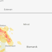
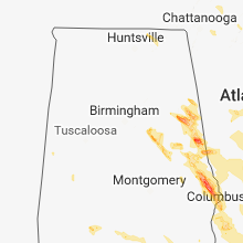
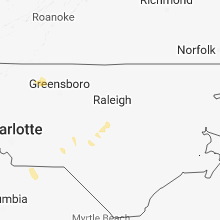
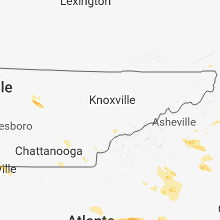
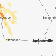
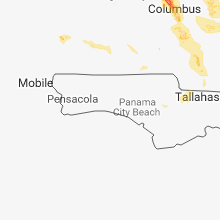
Hail Map for Saturday, July 21, 2018

Number of Impacted Households on 7/21/2018
0
Impacted by 1" or Larger Hail
0
Impacted by 1.75" or Larger Hail
0
Impacted by 2.5" or Larger Hail
Square Miles of Populated Area Impacted on 7/21/2018
0
Impacted by 1" or Larger Hail
0
Impacted by 1.75" or Larger Hail
0
Impacted by 2.5" or Larger Hail


Cities Most Affected by Hail Storms of 7/21/2018
| Hail Size | Demographics of Zip Codes Affected | ||||||
|---|---|---|---|---|---|---|---|
| City | Count | Average | Largest | Pop Density | House Value | Income | Age |
| Delta, AL | 2 | 2.75 | 3.00 | 16 | $63k | $34.1k | 42.7 |
| Froid, MT | 2 | 1.88 | 2.00 | 0 | $32k | $26.6k | 52.2 |
| Hickory, NC | 2 | 1.88 | 2.00 | 1125 | $122k | $42.0k | 39.7 |
| Peerless, MT | 2 | 1.75 | 1.75 | 0 | $32k | $27.3k | 52.5 |
| Woodland, AL | 1 | 2.75 | 2.75 | 37 | $56k | $31.5k | 42.8 |
| Dacula, GA | 1 | 2.50 | 2.50 | 909 | $152k | $69.2k | 35.5 |
| Hendersonville, NC | 1 | 2.00 | 2.00 | 309 | $111k | $32.8k | 41.3 |
| Fruithurst, AL | 1 | 2.00 | 2.00 | 16 | $60k | $31.5k | 38.5 |
| Wedowee, AL | 1 | 1.75 | 1.75 | 39 | $74k | $26.5k | 45.3 |
| Marmarth, ND | 1 | 1.75 | 1.75 | 0 | $12k | $28.6k | 42.8 |
| Moravian Falls, NC | 1 | 1.75 | 1.75 | 48 | $93k | $39.4k | 43.2 |
| Phenix City, AL | 1 | 1.75 | 1.75 | 295 | $71k | $26.9k | 35.7 |
| Bainville, MT | 1 | 1.75 | 1.75 | 0 | $33k | $27.3k | 40.3 |
| Trenton, ND | 1 | 1.75 | 1.75 | 0 | $43k | $31.3k | 33.6 |
| Watford City, ND | 1 | 1.75 | 1.75 | 2 | $51k | $30.1k | 42.0 |
| Spartanburg, SC | 1 | 1.75 | 1.75 | 328 | $108k | $45.7k | 40.8 |
| Medora, ND | 1 | 1.75 | 1.75 | 0 | $57k | $33.3k | 47.7 |
| Lagrange, GA | 1 | 1.75 | 1.75 | 215 | $100k | $40.5k | 36.7 |
| Athens, GA | 1 | 1.75 | 1.75 | 925 | $70k | $22.4k | 25.7 |
| Lawrenceville, GA | 1 | 1.75 | 1.75 | 2417 | $0k | $0.0k | 32.0 |
| Reserve, MT | 1 | 1.75 | 1.75 | 0 | $78k | $28.9k | 54.3 |
Hail and Wind Damage Spotted on 7/21/2018
Filter by Report Type:Hail ReportsWind Reports
States Impacted
Alabama, Tennessee, Arizona, Georgia, North Carolina, Florida, Montana, Wyoming, Colorado, Nevada, South Carolina, North Dakota, South DakotaAlabama
| Local Time | Report Details |
|---|---|
| 7:00 AM CDT | Tree down at sunnydale road at alpine vie in etowah county AL, 55.5 miles NE of Birmingham, AL |
| 10:35 AM CDT | Tree dow in houston county AL, 77.3 miles NW of Tallahassee, FL |
| 2:43 PM CDT | Quarter sized hail reported near Estillfork, AL, 52.2 miles WSW of Chattanooga, TN, time estimated from radar. |
| 4:15 PM CDT | Ping Pong Ball sized hail reported near Delta, AL, 63.6 miles N of Auburn, AL, trained spotter reported ping pong sized hail in the hollis crossroads community. |
| 4:27 PM CDT | Tea Cup sized hail reported near Delta, AL, 63.6 miles N of Auburn, AL, 3 inch diameter hail now reported near hollis crossroads community. |
| 4:27 PM CDT | Tennis Ball sized hail reported near Delta, AL, 61.6 miles N of Auburn, AL, estimated tennis ball sized hail reported in far northeast clay county. time estimated by radar. |
| 4:30 PM CDT | Hen Egg sized hail reported near Fruithurst, AL, 65.1 miles W of Atlanta, GA, estimated 2 inch diameter hail reported northeast of heflin. |
| 4:48 PM CDT | Golf Ball sized hail reported near Wedowee, AL, 48.4 miles N of Auburn, AL, golf ball sized hail reported near wedowee. |
| 4:48 PM CDT | Quarter sized hail reported near Woodland, AL, 52.8 miles N of Auburn, AL, quarter sized hail now reported near woodland in randolph county. |
| 4:58 PM CDT | Quarter sized hail reported near Wedowee, AL, 48.4 miles N of Auburn, AL, report of hail large enough to crack car windshields near wedowee. |
| 5:25 PM CDT | Baseball sized hail reported near Woodland, AL, 56.7 miles N of Auburn, AL, baseball sized hail reported near morrison crossroads community. |
| 5:37 PM CDT | Ping Pong Ball sized hail reported near Opelika, AL, 11.2 miles ENE of Auburn, AL, at least golf ball sized hail reported east of opelika... time estimated by radar. |
| 5:40 PM CDT | Trees and power lines down with some damage to an apartment complex near opelika. probable tornado. time approximat in lee county AL, 6.6 miles ENE of Auburn, AL |
| 5:48 PM CDT | Damage reported by lee county ema... possible tornado. time and location approximat in lee county AL, 8.6 miles ENE of Auburn, AL |
| 5:52 PM CDT | Several trees downed... fallen in different directions. probable tornado. time and location approximat in lee county AL, 7.7 miles E of Auburn, AL |
| 5:54 PM CDT | Highway 169 south blocked roughly 1 mile south of the interstate 85 corridor... possible tornado. time approximat in lee county AL, 7.7 miles E of Auburn, AL |
| 5:55 PM CDT | Reports of several structures damaged near this location. time and location approximate. probable tornad in lee county AL, 7.7 miles E of Auburn, AL |
| 6:18 PM CDT | Golf Ball sized hail reported near Phenix City, AL, 24.7 miles ESE of Auburn, AL, golf ball sized hail and winds estimated 50-60 mph winds reported by trained spotter/amateur radio operator. |
| 6:25 PM CDT | Quarter sized hail reported near Phenix City, AL, 25 miles ESE of Auburn, AL, at least quarter sized hail reported near ladonia. |
| 6:25 PM CDT | Several trees down across russell county. the roof of an ambulance shelter was damaged near seale. time and location approximat in russell county AL, 23.6 miles SE of Auburn, AL |
| 6:32 PM CDT | Quarter sized hail reported near Seale, AL, 23.6 miles SE of Auburn, AL, quarter sized hail reported north of seale in russell county by meteorologist. |
| 6:35 PM CDT | Ping Pong Ball sized hail reported near Phenix City, AL, 24.5 miles ESE of Auburn, AL, time approximate. |
| 6:52 PM CDT | 2 pine trees reported down. time approximat in russell county AL, 24.5 miles SE of Auburn, AL |
| 12:45 AM CDT | Several trees down in the enterprise are in coffee county AL, 71.8 miles NNE of Miramar Beach, FL |
| 1:48 AM CDT | Power outage due to tree down along opal roa in geneva county AL, 74.4 miles NE of Miramar Beach, FL |
| 1:50 AM CDT | Power outage due to tree down on w cook roa in houston county AL, 73.8 miles NE of Miramar Beach, FL |
Tennessee
| Local Time | Report Details |
|---|---|
| 8:24 AM EDT | Several trees and power lines dow in monroe county TN, 46 miles SSW of Knoxville, TN |
| 5:35 PM EDT | Quarter sized hail reported near Decatur, TN, 33.6 miles NE of Chattanooga, TN |
| 6:05 PM EDT | Multiple trees and powerlines dow in hamilton county TN, 14.7 miles E of Chattanooga, TN |
| 6:40 PM EDT | Several trees down across the count in polk county TN, 52.1 miles E of Chattanooga, TN |
| 7:20 PM EDT | Quarter sized hail reported near Townsend, TN, 25.6 miles SSE of Knoxville, TN |
Arizona
| Local Time | Report Details |
|---|---|
| 5:25 AM MST | Desert research institute spot road station recorded gust of 60 mp in yuma county AZ, 74.9 miles E of Yuma, AZ |
| 10:15 AM MST | Lake mead dispatch reports multiple boats swamped on lake mohav in mohave county AZ, 53 miles NNW of Lake Havasu City, AZ |
Georgia
| Local Time | Report Details |
|---|---|
| 11:05 AM EDT | Two trees down a jones mill road and hardy cooper roa in terrell county GA, 78.6 miles SE of Auburn, AL |
| 11:10 AM EDT | Trees down on highway 118 between bonwood and dawso in terrell county GA, 83.9 miles SE of Auburn, AL |
| 11:30 AM EDT | Media report of trees down on camp osborn roa in worth county GA, 65.8 miles W of Douglas, GA |
| 11:30 AM EDT | Reports of several trees down around the city of douglas. time estimated from radar in coffee county GA, 0.3 miles N of Douglas, GA |
| 11:30 AM EDT | Report of a tree down near general coffee state park along highway 3 in coffee county GA, 5.9 miles E of Douglas, GA |
| 11:30 AM EDT | Emergency management reports 5 to 6 trees down along with several power lines near the 4th street exit of highway 32 west. time estimated from radar dat in bacon county GA, 19.6 miles E of Douglas, GA |
| 11:35 AM EDT | Trees down across the count in early county GA, 74.5 miles NNW of Tallahassee, FL |
| 11:42 AM EDT | Reports of trees down on homes and numerous power lines dow in calhoun county GA, 73.9 miles NNW of Tallahassee, FL |
| 12:06 PM EDT | Numerous trees and power lines reported down across miller count in miller county GA, 57.8 miles NNW of Tallahassee, FL |
| 12:06 PM EDT | Trees and power lines reported down across baker count in baker county GA, 63.8 miles N of Tallahassee, FL |
| 12:06 PM EDT | Power lines down near highway 27 and 91. reported via ga 511 websit in miller county GA, 57.8 miles NNW of Tallahassee, FL |
| 12:09 PM EDT | Tree down on a powerline near the intersection of ga-38 and alberta r in wayne county GA, 50.7 miles E of Douglas, GA |
| 12:24 PM EDT | Tree down on power lines on s turkey r in mitchell county GA, 58.6 miles N of Tallahassee, FL |
| 12:30 PM EDT | Trees reported down along highway 31 in mitchell county GA, 51.1 miles N of Tallahassee, FL |
| 12:35 PM EDT | Tree down on highway 97 nort in decatur county GA, 40.4 miles NNW of Tallahassee, FL |
| 12:40 PM EDT | Tree down blocking the road at 2708 twin lakes d in decatur county GA, 35.3 miles NNW of Tallahassee, FL |
| 12:42 PM EDT | Tree down on palmer roa in decatur county GA, 35.1 miles NNW of Tallahassee, FL |
| 12:54 PM EDT | Reports of multiple trees down across thomas count in thomas county GA, 32.9 miles NNE of Tallahassee, FL |
| 6:08 PM EDT | Golf Ball sized hail reported near Lagrange, GA, 39.5 miles NE of Auburn, AL |
| 6:17 PM EDT | Quarter sized hail reported near Lagrange, GA, 35.7 miles NE of Auburn, AL, lasted for several minutes. started as pea and increased to dime and quarters. |
| 6:36 PM EDT | Ping Pong Ball sized hail reported near Lagrange, GA, 39.7 miles NE of Auburn, AL, from social media report with photo. |
| 7:00 PM EDT | Quarter sized hail reported near Atlanta, GA, 6.4 miles SSW of Atlanta, GA, public report of quarter sized hail |
| 7:10 PM EDT | Quarter sized hail reported near Atlanta, GA, 5.7 miles SE of Atlanta, GA, hail report on social media. size estimated from photo. |
| 7:11 PM EDT | Tree down on a house and a tree down on powerline in fulton county GA, 2.3 miles SSE of Atlanta, GA |
| 7:33 PM EDT | Ping Pong Ball sized hail reported near Lithonia, GA, 16.4 miles E of Atlanta, GA |
| 7:58 PM EDT | Ping Pong Ball sized hail reported near Stone Mountain, GA, 14.7 miles ENE of Atlanta, GA, hailed for about 10-15 minutes. largest was ping pong ball. |
| 8:11 PM EDT | Golf Ball sized hail reported near Lawrenceville, GA, 28.6 miles ENE of Atlanta, GA, social media photo and report of golf ball hail near the lawrenceville airport |
| 8:13 PM EDT | Tennis Ball sized hail reported near Dacula, GA, 32.6 miles ENE of Atlanta, GA, numerous golf ball hail stones with some tennis ball hail mixed in. harbins rd and hwy 316. confirmed by another report in the area from a trusted source. |
| 8:13 PM EDT | Quarter sized hail reported near Dacula, GA, 32.4 miles ENE of Atlanta, GA, hail of several sizes falling in the harbin oaks drive area. quarter was the largest. |
| 8:30 PM EDT | Ping Pong Ball sized hail reported near Winder, GA, 41.3 miles ENE of Atlanta, GA, multiple reports of quarter to possibly ping pong hail in barrow county. |
| 8:42 PM EDT | Quarter sized hail reported near Bogart, GA, 53.3 miles ENE of Atlanta, GA, 7 miles west of athens |
| 8:50 PM EDT | Golf Ball sized hail reported near Athens, GA, 60.1 miles ENE of Atlanta, GA, golf ball hail report on social media. |
| 9:00 PM EDT | Piece of sheet metal flew into the ecology building at the university of georgia. several trees were reported down in the are in clarke county GA, 60.2 miles ENE of Atlanta, GA |
| 9:05 PM EDT | Multiple trees and powerlines downed on the east side of town. trees reported on 2 to 3 homes. no inuries or entrapments reporte in clarke county GA, 61.1 miles ENE of Atlanta, GA |
| 9:15 PM EDT | Numerous trees down throughout the count in randolph county GA, 70.5 miles SE of Auburn, AL |
| 9:25 PM EDT | Several trees down throughout the count in terrell county GA, 83.5 miles SE of Auburn, AL |
| 9:30 PM EDT | Several trees dow in calhoun county GA, 81.8 miles NNW of Tallahassee, FL |
| 9:45 PM EDT | Several trees dow in calhoun county GA, 78 miles NNW of Tallahassee, FL |
| 10:00 PM EDT | Several trees dow in calhoun county GA, 73.6 miles N of Tallahassee, FL |
| 10:25 PM EDT | Several trees down throughout the count in miller county GA, 57.6 miles NNW of Tallahassee, FL |
| 10:25 PM EDT | Several trees down throughout the count in baker county GA, 60.8 miles N of Tallahassee, FL |
| 10:45 PM EDT | Tree dow in mitchell county GA, 44.1 miles N of Tallahassee, FL |
| 10:45 PM EDT | Tree dow in mitchell county GA, 49.4 miles NNW of Tallahassee, FL |
| 10:50 PM EDT | Tree down on power lines on vada roa in decatur county GA, 42.4 miles NNW of Tallahassee, FL |
| 10:55 PM EDT | Several trees down on highway 26 in decatur county GA, 33.3 miles NNW of Tallahassee, FL |
| 10:55 PM EDT | Trees down on rock pond roa in decatur county GA, 41.2 miles NNW of Tallahassee, FL |
| 10:55 PM EDT | Large tree down on power lines highway 31 in decatur county GA, 42.9 miles NNW of Tallahassee, FL |
| 11:05 PM EDT | Social media report of shingles blown off a roof in whigha in grady county GA, 31.1 miles N of Tallahassee, FL |
| 11:10 PM EDT | Report of a vehicle running into a tree near the tired creek road and jones road are in grady county GA, 26.1 miles NNW of Tallahassee, FL |
| 11:15 PM EDT | Social media report of power lines down in a yard at 5407 highway 11 in grady county GA, 22.3 miles N of Tallahassee, FL |
North Carolina
| Local Time | Report Details |
|---|---|
| 11:06 AM EDT | Trees were reported down at along kennebec church rd near the harnett/wake county lin in harnett county NC, 18.8 miles SSW of Raleigh, NC |
| 5:55 PM EDT | 911 call center reported trees and power lines down in the green hill area. time estimated from rada in rutherford county NC, 51 miles NE of Greenville, SC |
| 6:06 PM EDT | Quarter sized hail reported near Morganton, NC, 59.8 miles NW of Charlotte, NC, trained spotter reported quarter size hail in morganton. |
| 6:10 PM EDT | Quarter sized hail reported near Drexel, NC, 56.7 miles NW of Charlotte, NC, quarter (1.00 in) size hail reported on et camp rd near drexel |
| 6:15 PM EDT | Hen Egg sized hail reported near Hendersonville, NC, 42.1 miles NNE of Greenville, SC, trained spotter reported 2 inch (2.00 in) size hail on sugarloaf mountain rd in edneyville. time estimated from radar. |
| 6:25 PM EDT | Ping Pong Ball sized hail reported near Forest City, NC, 49.5 miles NE of Greenville, SC, social media reported ping pong ball (1.50 in) size hail in the shiloh community. time estimated from radar. |
| 6:40 PM EDT | Hen Egg sized hail reported near Hickory, NC, 45.8 miles NNW of Charlotte, NC |
| 6:40 PM EDT | Quarter sized hail reported near Rutherfordton, NC, 49.6 miles NE of Greenville, SC, social media reported quarter (1.00 in) size hail in harris. time estimated from radar. |
| 6:40 PM EDT | Quarter sized hail reported near Hickory, NC, 45 miles NW of Charlotte, NC, social media reported quarter (1.00 in) size hail in hickory. time estimated from radar. |
| 6:40 PM EDT | Half Dollar sized hail reported near Taylorsville, NC, 48.2 miles NNW of Charlotte, NC, trained spotter reported half dollar (1.25 in) size hail just southwest of bethlehem. |
| 6:43 PM EDT | Quarter sized hail reported near Lenoir, NC, 59.6 miles NW of Charlotte, NC |
| 6:50 PM EDT | 911 call center reported trees and power lines down near rutherfordton. time estimated from rada in rutherford county NC, 50.6 miles NE of Greenville, SC |
| 6:50 PM EDT | Golf Ball sized hail reported near Hickory, NC, 48.5 miles NNW of Charlotte, NC, broadcast media reported golf ball (1.75 in) size hail in bethlehem. time estimated from radar. |
| 7:12 PM EDT | Golf Ball sized hail reported near Moravian Falls, NC, 60.1 miles NNW of Charlotte, NC, golfball-size hail was observed along price road. |
| 7:28 PM EDT | A tree was blown down along mountain park road by thunderstorm wind in surry county NC, 78 miles ESE of Bristol, TN |
| 8:05 PM EDT | A tree was blown down along ararat road by thunderstorm wind in surry county NC, 69.5 miles SSW of Roanoke, VA |
| 9:32 PM EDT | A power line was reported down across page street in ellerb in richmond county NC, 61.9 miles E of Charlotte, NC |
| 9:40 PM EDT | One tree was reported down along foxfire roa in moore county NC, 64.3 miles SW of Raleigh, NC |
| 10:05 PM EDT | One tree was reported down on coldwater road near u.s. highway 15 in guilford county NC, 72 miles S of Roanoke, VA |
| 10:13 PM EDT | One tree was reported down on stanley huff road near deer meadow lan in guilford county NC, 76 miles S of Roanoke, VA |
| 10:20 PM EDT | Quarter sized hail reported near Sanford, NC, 41.5 miles SW of Raleigh, NC, dime to quarter size hail was reported along buffalo lake road... near carolina lakes road. |
| 10:37 PM EDT | One tree was reported down on stanley huff road near deer meadow lan in guilford county NC, 76 miles S of Roanoke, VA |
| 11:06 PM EDT | Trees were reported down at along kennebec church rd near the harnett/wake county lin in harnett county NC, 18.8 miles SSW of Raleigh, NC |
| 11:23 PM EDT | Multiple trees were reported down near nc highway 42 in southeastern wake count in wake county NC, 13.5 miles S of Raleigh, NC |
| 11:28 PM EDT | One tree was reported down near the intersection of fanny brown road and banks roa in wake county NC, 10.4 miles SSW of Raleigh, NC |
| 1:40 AM EDT | Multiple trees reported down near coats... n in harnett county NC, 26 miles S of Raleigh, NC |
Florida
| Local Time | Report Details |
|---|---|
| 11:48 AM CDT | Reports of power lines down on hwy 73 near gray r in calhoun county FL, 55 miles W of Tallahassee, FL |
| 1:06 PM EDT | Trees reported down in quinc in gadsden county FL, 20.6 miles WNW of Tallahassee, FL |
| 1:22 PM EDT | Fallen trees and limbs resulted in a power outage along lake road near tecumseh road via duke energy websit in jefferson county FL, 25.8 miles ENE of Tallahassee, FL |
| 1:30 PM EDT | Tree down on power lines at 6303 miccosukee road. reported via twitte in leon county FL, 7.8 miles ENE of Tallahassee, FL |
| 1:30 PM EDT | Tree reported down in crawfordvill in wakulla county FL, 18.7 miles SSW of Tallahassee, FL |
| 1:40 PM EDT | Fallen trees and limbs resulted in a power outage along gamble road via duke energy websit in jefferson county FL, 16.5 miles ENE of Tallahassee, FL |
| 1:42 PM EDT | Fallen tree and limbs resulted in a power outage in the drifton area via duke energy websit in jefferson county FL, 24.3 miles E of Tallahassee, FL |
| 1:42 PM EDT | Reports of numerous trees and power lines down across jefferson count in jefferson county FL, 23.4 miles E of Tallahassee, FL |
| 1:42 PM EDT | Trees and power lines reported down across leon county... mostly from tallahassee eastwar in leon county FL, 3 miles E of Tallahassee, FL |
| 1:45 PM EDT | Tree down in southbound lane near w capps highway and st augustine roa in jefferson county FL, 19.2 miles E of Tallahassee, FL |
| 1:45 PM EDT | Debris blocking roadway along highway 27 east of highway 5 in jefferson county FL, 16.3 miles E of Tallahassee, FL |
| 1:55 PM EDT | Trees reported down in greenvill in madison county FL, 38.9 miles E of Tallahassee, FL |
| 2:00 PM EDT | Trees reported down in madiso in madison county FL, 52 miles E of Tallahassee, FL |
| 2:05 PM EDT | Trees reported down in le in madison county FL, 58.6 miles E of Tallahassee, FL |
| 2:20 PM EDT | Fallen trees and limbs resulted in a power outage on mcdaniel road via duke energy websit in taylor county FL, 44.8 miles ESE of Tallahassee, FL |
| 3:30 PM EDT | Numerous trees and power lines reported down throughout dixie county. reports in all cities except jonesboro and horsesho in dixie county FL, 88.3 miles SE of Tallahassee, FL |
| 3:45 PM EDT | Five trees and privacy fence knocked out near nw 110th avenue and nw 21st stree in marion county FL, 72.6 miles NW of Orlando, FL |
| 11:30 PM EDT | Tree across the road at meridian and county road 1 in leon county FL, 15.9 miles N of Tallahassee, FL |
| 11:50 PM EDT | Tree down at delta and pinewood roa in leon county FL, 2.1 miles N of Tallahassee, FL |
| 11:50 PM EDT | Tree down near the intersection of wadesboro road and baum roa in leon county FL, 12.7 miles ENE of Tallahassee, FL |
| 11:55 PM EDT | Oak tree down near 6th street and terrace stree in leon county FL, 1.5 miles NNE of Tallahassee, FL |
| 11:55 PM EDT | Tree down at 3028 walden roa in leon county FL, 7.7 miles ENE of Tallahassee, FL |
| 12:00 AM EDT | Tree down near the intersection of magnolia drive and s meridian stree in leon county FL, 1.4 miles S of Tallahassee, FL |
| 12:00 AM EDT | Tree down at 2181 orange ave eas in leon county FL, 3.2 miles SE of Tallahassee, FL |
Montana
| Local Time | Report Details |
|---|---|
| 12:27 PM MDT | Quarter sized hail reported near Opheim, MT, 42.2 miles NNE of Glasgow, MT |
| 12:34 PM MDT | Quarter sized hail reported near Opheim, MT, 47.3 miles NNE of Glasgow, MT |
| 1:12 PM MDT | Quarter sized hail reported near Larslan, MT, 41.2 miles NNE of Glasgow, MT |
| 1:22 PM MDT | Ping Pong Ball sized hail reported near Reserve, MT, 59.1 miles WNW of Williston, ND, also got 0.10 inches of rainfall. |
| 1:25 PM MDT | Golf Ball sized hail reported near Reserve, MT, 64.6 miles WNW of Williston, ND |
| 1:33 PM MDT | Golf Ball sized hail reported near Peerless, MT, 55.5 miles NE of Glasgow, MT, hail up to golf ball size along with 0.5 inches of rain. time estimated from radar. |
| 1:47 PM MDT | Golf Ball sized hail reported near Peerless, MT, 55.5 miles NE of Glasgow, MT, in addition to the hail... one half inch of rain fell. |
| 2:20 PM MDT | In addition to the wind... they also had one inch hai in daniels county MT, 65.6 miles ENE of Glasgow, MT |
| 2:51 PM MDT | Quarter sized hail reported near Flaxville, MT, 74.7 miles ENE of Glasgow, MT |
| 3:44 PM MDT | Ping Pong Ball sized hail reported near Froid, MT, 42.2 miles WNW of Williston, ND, report relayed from facebook. storm also broke windows on the north side of their house. |
| 3:45 PM MDT | Half Dollar sized hail reported near Hammond, MT, 73.3 miles NNE of Gillette, WY |
| 3:50 PM MDT | Report relayed from facebook. home weather station recorded wind speed. 2.8 inches of rai in roosevelt county MT, 42.4 miles WNW of Williston, ND |
| 3:55 PM MDT | Hen Egg sized hail reported near Froid, MT, 42.2 miles WNW of Williston, ND, report relayed from facebook. in addition to hail... extensive tree damage reported. |
| 3:56 PM MDT | In addition to the wind... they received one inch hai in roosevelt county MT, 42.5 miles WNW of Williston, ND |
| 4:00 PM MDT | Quarter sized hail reported near Alzada, MT, 60.8 miles NNE of Gillette, WY |
| 4:00 PM MDT | Report relayed through facebook with pictures. also received quarter sized hail and damaged outdoor swingse in roosevelt county MT, 51.3 miles W of Williston, ND |
| 4:11 PM MDT | Golf Ball sized hail reported near Froid, MT, 35.3 miles WNW of Williston, ND, also had a 52 mph wind gust. reported via facebook. |
| 4:15 PM MDT | Quarter sized hail reported near Culbertson, MT, 37.1 miles W of Williston, ND |
| 4:15 PM MDT | Storm damage reported in roosevelt county MT, 40.9 miles W of Williston, ND |
| 4:19 PM MDT | 10 to 11 bnsf train cars deraile in roosevelt county MT, 34.1 miles W of Williston, ND |
| 4:30 PM MDT | Golf Ball sized hail reported near Bainville, MT, 27.7 miles W of Williston, ND, report relayed from twitter. |
| 5:05 PM MDT | Storm damage reported in richland county MT, 38.7 miles WSW of Williston, ND |
| 5:33 PM MDT | Awos station sdy... sidney airpor in richland county MT, 40.1 miles SW of Williston, ND |
| 6:34 PM MDT | 61 mph wind gus in madison county MT, 47 miles SW of Bozeman, MT |
| 8:14 PM MDT | Storm damage reported in stillwater county MT, 22.4 miles W of Billings, MT |
Wyoming
| Local Time | Report Details |
|---|---|
| 2:35 PM MDT | Quarter sized hail reported near Weston, WY, 30.7 miles N of Gillette, WY, at least as big as quarters |
| 4:58 PM MDT | Half Dollar sized hail reported near Gillette, WY, 5.5 miles SSE of Gillette, WY, delayed report. time estimated from radar. |
| 5:02 PM MDT | Quarter sized hail reported near Gillette, WY, 5.7 miles SE of Gillette, WY, mping report |
| 5:14 PM MDT | Quarter sized hail reported near Gillette, WY, 8.4 miles SE of Gillette, WY |
| 7:55 PM MDT | At least 60 mph gusts... sustained 40-50 mph in weston county WY, 48.9 miles WSW of Rapid City, SD |
| 7:55 PM MDT | Storm damage reported in weston county WY, 55.6 miles WSW of Rapid City, SD |
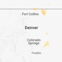
Colorado
| Local Time | Report Details |
|---|---|
| 3:09 PM MDT | Storm damage reported in las animas county CO, 70.8 miles SSE of Pueblo, CO |
| 5:39 PM MDT | Storm damage reported in weld county CO, 71.4 miles SSW of Scottsbluff, NE |
| 5:40 PM MDT | Storm damage reported in weld county CO, 69.3 miles SSW of Scottsbluff, NE |
| 5:40 PM MDT | Ping Pong Ball sized hail reported near Grover, CO, 78.7 miles SSW of Scottsbluff, NE, hailed for about 20 minutes. |
| 6:48 PM MDT | Storm damage reported in lincoln county CO, 79.7 miles NE of Pueblo, CO |
| 9:52 PM MDT | Corrects previous non-tstm wnd gst report from firstview. mesonet station co068... firstvie in cheyenne county CO, 89.7 miles WSW of Colby, KS |
Nevada
| Local Time | Report Details |
|---|---|
| 3:40 PM PDT | Scaffolding collapsed from gusty outflow winds between 50 to 55 mph. no injuries but the roadway is blocked. airport also gusted to 51 mph. nws office gusted to 43 knot in elko county NV, 0.6 miles SE of Elko, NV |
South Carolina
| Local Time | Report Details |
|---|---|
| 6:50 PM EDT | Quarter sized hail reported near Westminster, SC, 29.2 miles WSW of Greenville, SC, mostly dime to nickel size |
| 6:50 PM EDT | 911 call center reported a few trees down in the southern part of the county. time estimated from rada in oconee county SC, 30 miles SW of Greenville, SC |
| 7:55 PM EDT | Fire dept/rescue reported trees and powerlines down in drayton area. time estimated from rada in spartanburg county SC, 40.4 miles ENE of Greenville, SC |
| 7:55 PM EDT | Fire dept/rescue reported trees down on asheville highway. time estimated from rada in spartanburg county SC, 38.2 miles ENE of Greenville, SC |
| 7:55 PM EDT | Ping Pong Ball sized hail reported near Spartanburg, SC, 38.8 miles ENE of Greenville, SC |
| 8:00 PM EDT | Golf Ball sized hail reported near Spartanburg, SC, 40.7 miles E of Greenville, SC |
| 8:20 PM EDT | 911 call center reported scattered trees down. time estimated from rada in oconee county SC, 22 miles W of Greenville, SC |
| 8:30 PM EDT | 911 call center reported trees down in the far southern part of cherokee county. time estimated from rada in cherokee county SC, 49.5 miles WSW of Charlotte, NC |
| 8:36 PM EDT | Fire dept/rescue reported a tree down blocking jocassee lake rd. time estimated from rada in oconee county SC, 21.2 miles WNW of Greenville, SC |
| 9:00 PM EDT | Schp reported a tree down at 725 pickens dr. time estimated from rada in anderson county SC, 8.4 miles S of Greenville, SC |
| 9:25 PM EDT | Trained spotter reported a tree fell on and destroyed a mobile home at west whitner street and mimosa par in anderson county SC, 23.1 miles S of Greenville, SC |
| 9:26 PM EDT | Schp reported a tree down at n mechanic st and canterbury rd in anderson county SC, 16.4 miles SW of Greenville, SC |
| 9:30 PM EDT | Amateur radio reported trees down on forest dr at creekside dr. time estimated form rada in oconee county SC, 19.5 miles WSW of Greenville, SC |
| 9:31 PM EDT | Schp reported a tree down at spearman rd and cherokee rd in anderson county SC, 12.1 miles SSE of Greenville, SC |
| 9:38 PM EDT | Quarter sized hail reported near Anderson, SC, 21.6 miles S of Greenville, SC |
| 9:40 PM EDT | Tree across oak hill drive at midway roa in anderson county SC, 19.4 miles S of Greenville, SC |
| 9:45 PM EDT | Quarter sized hail reported near Anderson, SC, 21.8 miles SSW of Greenville, SC, amateur radio reported quarter (1.00 in) size hail on whitehall rd in west anderson. time estimated from radar. |
| 10:00 PM EDT | Schp reported a tree down at highway 76 and shirley store rd in anderson county SC, 24.2 miles S of Greenville, SC |
| 10:00 PM EDT | Emergency management office reported major damage to a home on jones chapel roa in anderson county SC, 30.5 miles SSE of Greenville, SC |
| 10:04 PM EDT | Schp reported a tree down at henry thomas rd and murphy ln in anderson county SC, 24.2 miles SSE of Greenville, SC |
| 10:05 PM EDT | Schp reported a tree down at belton honea path hwy in anderson county SC, 26.7 miles SSE of Greenville, SC |
| 10:20 PM EDT | Schp reported a tree down at trail rd and alewine rd in anderson county SC, 31.4 miles S of Greenville, SC |
| 10:22 PM EDT | Schp reported a tree down at sexton gin rd and pruitt rd in anderson county SC, 34 miles S of Greenville, SC |
| 10:22 PM EDT | Schp reported a tree down at good hope church rd and carl gray rd in anderson county SC, 34.3 miles S of Greenville, SC |
| 10:30 PM EDT | Schp reported a tree down at highway 81 and highway 71 in abbeville county SC, 42.8 miles S of Greenville, SC |
| 10:30 PM EDT | Schp reported a tree down at highway 81 and barnes station rd in anderson county SC, 42.2 miles S of Greenville, SC |
| 10:42 PM EDT | Schp reported a tree down at moorefield st and robertson st in greenwood county SC, 42.3 miles SSE of Greenville, SC |
| 12:22 AM EDT | Sc hwy patrol reported trees down on sc 23 at key road. time estimated based on rada in edgefield county SC, 19.4 miles NNW of Augusta, GA |
North Dakota
| Local Time | Report Details |
|---|---|
| 5:54 PM CDT | Quarter sized hail reported near Williston, ND, 17.1 miles W of Williston, ND, delayed report. |
| 6:21 PM CDT | Golf Ball sized hail reported near Trenton, ND, 9.4 miles WSW of Williston, ND |
| 7:10 PM CDT | Golf Ball sized hail reported near Watford City, ND, 27.6 miles SE of Williston, ND |
| 6:15 PM MDT | Golf Ball sized hail reported near Marmarth, ND, 94.1 miles E of Miles City, MT, report via facebook. time estimated from radar. |
| 7:25 PM CDT | Quarter sized hail reported near Watford City, ND, 28.7 miles SSE of Williston, ND |
| 7:49 PM CDT | Quarter sized hail reported near Mandaree, ND, 52.4 miles ESE of Williston, ND |
| 6:50 PM MDT | Golf Ball sized hail reported near Medora, ND, 96.6 miles S of Williston, ND, quarter to golfball sized hail. |
| 7:22 PM MDT | Measured by personal weather statio in dunn county ND, 75.7 miles SSE of Williston, ND |
South Dakota
| Local Time | Report Details |
|---|---|
| 5:15 PM MDT | Ping Pong Ball sized hail reported near Deadwood, SD, 27.1 miles WNW of Rapid City, SD, mostly small hail... but a few ping pong ball sized |
| 5:33 PM MDT | Quarter sized hail reported near Deadwood, SD, 22.4 miles WNW of Rapid City, SD |
| 6:40 PM MDT | Quarter sized hail reported near Rapid City, SD, 13.1 miles WSW of Rapid City, SD |
| 6:45 PM MDT | Live video shows large tree downed by winds in pennington county SD, 3.7 miles WSW of Rapid City, SD |
| 6:47 PM MDT | Winds downed poplar tree and damaged garage door in pennington county SD, 1.7 miles SSW of Rapid City, SD |
| 6:57 PM MDT | Gusting over 50 mph for last 15 minutes in pennington county SD, 4.2 miles S of Rapid City, SD |
| 7:10 PM MDT | Storm damage reported in pennington county SD, 8.8 miles ESE of Rapid City, SD |
| 7:22 PM MDT | Quarter sized hail reported near Rapid City, SD, 7.6 miles SSE of Rapid City, SD |
| 7:22 PM MDT | Storm damage reported in pennington county SD, 7.6 miles SSE of Rapid City, SD |
| 7:25 PM MDT | Storm damage reported in pennington county SD, 8.8 miles ESE of Rapid City, SD |
Connect with Interactive Hail Maps