

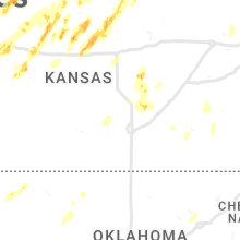
Hail Map for Thursday, May 12, 2022

Number of Impacted Households on 5/12/2022
0
Impacted by 1" or Larger Hail
0
Impacted by 1.75" or Larger Hail
0
Impacted by 2.5" or Larger Hail
Square Miles of Populated Area Impacted on 5/12/2022
0
Impacted by 1" or Larger Hail
0
Impacted by 1.75" or Larger Hail
0
Impacted by 2.5" or Larger Hail


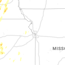


Cities Most Affected by Hail Storms of 5/12/2022
| Hail Size | Demographics of Zip Codes Affected | ||||||
|---|---|---|---|---|---|---|---|
| City | Count | Average | Largest | Pop Density | House Value | Income | Age |
| Saint Joseph, MN | 3 | 1.77 | 1.80 | 108 | $107k | $46.9k | 27.6 |
| Grantsburg, WI | 2 | 1.88 | 2.00 | 17 | $78k | $37.8k | 44.0 |
| Avon, MN | 2 | 1.78 | 1.80 | 67 | $114k | $48.8k | 41.3 |
| De Witt, NE | 1 | 2.50 | 2.50 | 8 | $64k | $40.7k | 45.1 |
| Grey Eagle, MN | 1 | 2.00 | 2.00 | 29 | $79k | $34.5k | 48.1 |
| Lincoln, KS | 1 | 2.00 | 2.00 | 6 | $37k | $31.8k | 44.7 |
| Foley, MN | 1 | 2.00 | 2.00 | 33 | $88k | $45.1k | 35.3 |
| Saint Cloud, MN | 1 | 1.75 | 1.75 | 403 | $112k | $41.3k | 24.9 |
| Doniphan, NE | 1 | 1.75 | 1.75 | 13 | $94k | $45.4k | 41.9 |
| Waite Park, MN | 1 | 1.75 | 1.75 | 822 | $95k | $33.7k | 32.6 |
| Sartell, MN | 1 | 1.75 | 1.75 | 870 | $124k | $55.5k | 33.3 |
| Ceresco, NE | 1 | 1.75 | 1.75 | 11 | $94k | $48.9k | 40.9 |
| Hallam, NE | 1 | 1.75 | 1.75 | 10 | $83k | $44.5k | 41.1 |
| Collegeville, MN | 1 | 1.75 | 1.75 | 0 | $0k | $0.0k | 20.3 |
Hail and Wind Damage Spotted on 5/12/2022
Filter by Report Type:Hail ReportsWind Reports
States Impacted
Minnesota, Wisconsin, Kansas, Nebraska, South Dakota, Michigan, Texas, Mississippi, Iowa, North Dakota, Alabama, Louisiana, OklahomaMinnesota
| Local Time | Report Details |
|---|---|
| 7:22 AM CDT | Half Dollar sized hail reported near Sauk Rapids, MN, 56.7 miles NW of Minneapolis, MN, photo sent via facebook messenger. hail started at 722am and ended at 729am. mostly quarter size with 1.25 inch mixed in. |
| 7:28 AM CDT | Hen Egg sized hail reported near Foley, MN, 56.6 miles NNW of Minneapolis, MN, facebook photos of hail relayed by nws duluth. |
| 7:33 AM CDT | Ping Pong Ball sized hail reported near Foley, MN, 56.6 miles NNW of Minneapolis, MN, photo measurement. |
| 7:40 AM CDT | Half Dollar sized hail reported near Avon, MN, 73.1 miles NW of Minneapolis, MN |
| 9:35 AM CDT | Hen Egg sized hail reported near Grey Eagle, MN, 76.2 miles NE of Montevideo, MN, public report relayed by kasm radio. |
| 10:11 AM CDT | Quarter sized hail reported near Little Falls, MN, 89.5 miles NW of Minneapolis, MN |
| 10:15 AM CDT | Awos station klxl little falls a in morrison county MN, 84.7 miles NW of Minneapolis, MN |
| 10:16 AM CDT | Quarter sized hail reported near Little Falls, MN, 87.5 miles NW of Minneapolis, MN, photos of hail sent via facebook messenger. |
| 10:25 AM CDT | 6 to 8 inch tree branches down and trees down on power lines in pierz m in morrison county MN, 80.4 miles NNW of Minneapolis, MN |
| 11:00 AM CDT | 30 foot trees dow in stearns county MN, 65.9 miles WNW of Minneapolis, MN |
| 11:02 AM CDT | Golf Ball sized hail reported near Avon, MN, 72.4 miles NW of Minneapolis, MN |
| 11:06 AM CDT | Golf Ball sized hail reported near Avon, MN, 72.4 miles NW of Minneapolis, MN, trained spotter reports relayed by em. |
| 11:06 AM CDT | Golf Ball sized hail reported near Saint Joseph, MN, 68.9 miles NW of Minneapolis, MN, trained spotters reports relayed by em. |
| 11:10 AM CDT | Golf Ball sized hail reported near Saint Joseph, MN, 65.7 miles NW of Minneapolis, MN, photo on twitter. |
| 11:12 AM CDT | Golf Ball sized hail reported near Saint Joseph, MN, 65.3 miles NW of Minneapolis, MN |
| 11:17 AM CDT | Quarter sized hail reported near Saint Joseph, MN, 64.7 miles NW of Minneapolis, MN |
| 11:19 AM CDT | Golf Ball sized hail reported near Waite Park, MN, 61 miles NW of Minneapolis, MN |
| 11:23 AM CDT | Quarter sized hail reported near Waite Park, MN, 61 miles NW of Minneapolis, MN |
| 11:24 AM CDT | Golf Ball sized hail reported near Saint Cloud, MN, 59.2 miles NW of Minneapolis, MN |
| 11:25 AM CDT | Golf Ball sized hail reported near Sartell, MN, 63.9 miles NW of Minneapolis, MN |
| 11:30 AM CDT | Quarter sized hail reported near Saint Joseph, MN, 69.7 miles NW of Minneapolis, MN |
| 11:30 AM CDT | Quarter sized hail reported near Saint Cloud, MN, 63.1 miles NW of Minneapolis, MN |
| 11:30 AM CDT | Mesonet station mn017 clearwater 1s in wright county MN, 46.9 miles NW of Minneapolis, MN |
| 11:34 AM CDT | Asos station kstc st. cloud a in sherburne county MN, 55 miles NW of Minneapolis, MN |
| 11:36 AM CDT | Golf Ball sized hail reported near Collegeville, MN, 68.8 miles NW of Minneapolis, MN |
| 11:37 AM CDT | Quarter sized hail reported near Sauk Rapids, MN, 56.7 miles NW of Minneapolis, MN, hail with torrential rain from 11:37-11:48am. sent via facebook messenger. |
| 11:40 AM CDT | Asos station kstc st. cloud a in sherburne county MN, 55 miles NW of Minneapolis, MN |
| 12:08 PM CDT | Half Dollar sized hail reported near Princeton, MN, 43.6 miles NNW of Minneapolis, MN |
| 12:11 PM CDT | Quarter sized hail reported near Isle, MN, 78.9 miles SW of Duluth, MN, phoned in report. |
| 12:46 PM CDT | Half Dollar sized hail reported near Braham, MN, 51.4 miles N of Minneapolis, MN, picture with measuring tape with time estimated based on radar. |
| 12:55 PM CDT | Quarter sized hail reported near Rush City, MN, 51.3 miles NNE of Minneapolis, MN |
| 1:02 PM CDT | Quarter sized hail reported near Rush City, MN, 55.2 miles NNE of Minneapolis, MN |
| 1:02 PM CDT | Half Dollar sized hail reported near Rush City, MN, 53.2 miles NNE of Minneapolis, MN |
| 1:06 PM CDT | Quarter sized hail reported near Rush City, MN, 54.4 miles NNE of Minneapolis, MN, off-duty non-nws meteorologist reported 1 inch hail on the pine/chisago county border that started at 1:02pm and was still occuring at the time of the report. |
| 2:18 PM CDT | Quarter sized hail reported near Motley, MN, 78 miles S of Bemidji, MN, report from mping: quarter (1.00 in.). |
| 2:31 PM CDT | Quarter sized hail reported near Aitkin, MN, 78 miles W of Duluth, MN |
| 2:38 PM CDT | Quarter sized hail reported near Motley, MN, 78.3 miles S of Bemidji, MN |
| 2:45 PM CDT | Quarter sized hail reported near Nisswa, MN, 70.4 miles SSE of Bemidji, MN |
| 2:52 PM CDT | Quarter sized hail reported near Motley, MN, 77.7 miles S of Bemidji, MN, report from mping: quarter (1.00 in.). |
| 3:19 PM CDT | Quarter sized hail reported near Merrifield, MN, 77 miles SSE of Bemidji, MN, hail began at 1517. |
| 3:30 PM CDT | Quarter sized hail reported near Pine River, MN, 55.4 miles SSE of Bemidji, MN |
| 3:37 PM CDT | Quarter sized hail reported near Pine River, MN, 53.2 miles SSE of Bemidji, MN |
| 3:37 PM CDT | Half Dollar sized hail reported near Mcgregor, MN, 56.2 miles W of Duluth, MN |
| 3:40 PM CDT | Ping Pong Ball sized hail reported near Pine River, MN, 56.7 miles SSE of Bemidji, MN, report via social media with photo of numerous ping pong ball sized hailstones... maybe some up to golf ball size. observer states hail fell this afternoon. |
| 3:45 PM CDT | Half Dollar sized hail reported near Aitkin, MN, 83.5 miles WSW of Duluth, MN |
| 3:45 PM CDT | Half Dollar sized hail reported near Mcgregor, MN, 52.9 miles W of Duluth, MN, location approximate. half dollar size hail occurred approximately 1 n of horseshoe lake or 9 n of mcgregor. |
| 4:05 PM CDT | Ping Pong Ball sized hail reported near Deer River, MN, 51.9 miles E of Bemidji, MN |
| 4:10 PM CDT | Quarter sized hail reported near Deer River, MN, 51.2 miles E of Bemidji, MN |
| 4:15 PM CDT | Half Dollar sized hail reported near Deer River, MN, 54.6 miles E of Bemidji, MN, report from mping: half dollar (1.25 in.). |
| 4:37 PM CDT | Quarter sized hail reported near Cohasset, MN, 61.9 miles ESE of Bemidji, MN |
| 4:55 PM CDT | Quarter sized hail reported near Floodwood, MN, 40.4 miles WNW of Duluth, MN, time estimated by radar. hail size is estimated. spotter also measured 1.52 inches of rain. location approximate. |
| 5:15 PM CDT | Quarter sized hail reported near Floodwood, MN, 37.2 miles WNW of Duluth, MN |
| 5:23 PM CDT | Awos station klyv luverne airpor in rock county MN, 26.2 miles ENE of Sioux Falls, SD |
| 5:25 PM CDT | Mesonet station fw5856 luvern in rock county MN, 24.5 miles ENE of Sioux Falls, SD |
| 5:35 PM CDT | Mesonet station mn028 lake benton us-14 mile post in lincoln county MN, 54.1 miles NNE of Sioux Falls, SD |
| 5:43 PM CDT | Rwis sit in lyon county MN, 51.8 miles SSW of Montevideo, MN |
| 5:54 PM CDT | Rwis sit in lyon county MN, 30.1 miles SW of Montevideo, MN |
| 5:58 PM CDT | Awos station kmml marshall municipal airpor in lyon county MN, 35 miles S of Montevideo, MN |
| 6:00 PM CDT | Storm damage reported in yellow medicine county MN, 31.9 miles WSW of Montevideo, MN |
| 6:08 PM CDT | Measured at madison airport awo in lac qui parle county MN, 22.8 miles W of Montevideo, MN |
| 6:14 PM CDT | Report from mping: 1-inch tree limbs broken; shingles blown of in nobles county MN, 63.1 miles NNW of Storm Lake, IA |
| 6:15 PM CDT | Mesonet station mn033 hanley falls mn-23 mile post 9 in yellow medicine county MN, 18.8 miles SSE of Montevideo, MN |
| 6:15 PM CDT | Mesonet station mn038 dovray mn-30 mile post 4 in murray county MN, 61.8 miles S of Montevideo, MN |
| 6:20 PM CDT | 12 inch diameter trees down 5 miles nw of watson. dozens of additional trees down in vicinity. roads blocked by downed tree in chippewa county MN, 11.1 miles NW of Montevideo, MN |
| 6:23 PM CDT | Reported by canby airport awo in yellow medicine county MN, 30.7 miles WSW of Montevideo, MN |
| 6:28 PM CDT | Mesonet station mn071 mn-71 mile post 4 in cottonwood county MN, 67 miles SSE of Montevideo, MN |
| 6:32 PM CDT | Storm damage reported in big stone county MN, 50.7 miles NW of Montevideo, MN |
| 6:33 PM CDT | Appleton airport awo in swift county MN, 24 miles NW of Montevideo, MN |
| 6:39 PM CDT | Redwood falls airpor in redwood county MN, 40.8 miles SE of Montevideo, MN |
| 6:40 PM CDT | Trees down and steel building damaged near intersection of 40th st and hwy 29. time estimated by rada in swift county MN, 22.7 miles NNE of Montevideo, MN |
| 6:40 PM CDT | Radar estimated time; dented grain bin... trees uproote in big stone county MN, 42.6 miles NW of Montevideo, MN |
| 6:40 PM CDT | Large storage shed destroyed. large tree down. time estimated by rada in stevens county MN, 44.5 miles NNW of Montevideo, MN |
| 6:40 PM CDT | Grain silo destroyed. time estimated by rada in stevens county MN, 42.5 miles NNW of Montevideo, MN |
| 6:45 PM CDT | Power poles and 7 trees down. reported via twitter. photos included. time estimated by rada in stevens county MN, 46.9 miles N of Montevideo, MN |
| 6:45 PM CDT | Hwy 9 closed due to downed power lines. time estimate in swift county MN, 26.9 miles NNE of Montevideo, MN |
| 6:47 PM CDT | Corrects previous tstm wnd dmg report from chokio. significant infrastructure damage reported to the city of chokio including power poles snapped at base... live wire in stevens county MN, 48.1 miles NNW of Montevideo, MN |
| 6:48 PM CDT | Storm damage reported in big stone county MN, 54.5 miles NW of Montevideo, MN |
| 6:48 PM CDT | Rolled campers. time estimated by rada in roberts county SD, 72.7 miles NW of Montevideo, MN |
| 6:48 PM CDT | Hangers blown in and wall collapsed as well as antennas down at morris municipal airpor in stevens county MN, 44.4 miles NNW of Montevideo, MN |
| 6:48 PM CDT | Shingles pealed up on a roof... along with at least 2 large trees snapped. report via social media. time estimated via rada in traverse county MN, 62.8 miles NW of Montevideo, MN |
| 6:49 PM CDT | Storm damage reported in stevens county MN, 51.6 miles NNW of Montevideo, MN |
| 6:50 PM CDT | Mesonet station mn036 graceville 2 w (mndot in big stone county MN, 56.4 miles NW of Montevideo, MN |
| 6:51 PM CDT | Mesonet station bstm5 odessa 1 in big stone county MN, 37.1 miles NW of Montevideo, MN |
| 6:51 PM CDT | One silo and pole barn destroye in pope county MN, 33.6 miles NNE of Montevideo, MN |
| 6:55 PM CDT | Storm damage reported in kandiyohi county MN, 34.7 miles ENE of Montevideo, MN |
| 6:55 PM CDT | Trees down in tow in kandiyohi county MN, 34.9 miles ENE of Montevideo, MN |
| 6:59 PM CDT | *** 1 fatal *** grain bin fell on an occupied car... resulting in a fatalit in kandiyohi county MN, 35.7 miles E of Montevideo, MN |
| 7:00 PM CDT | Corrects previous non-tstm wnd dmg report from 1 w chokio. power lines pushed down near county rd 1 in stevens county MN, 48.5 miles NNW of Montevideo, MN |
| 7:00 PM CDT | Small to medium trees blown over. time estimated by rada in stevens county MN, 45.1 miles NNW of Montevideo, MN |
| 7:00 PM CDT | Significant damage reported to a home in holloway. reported via twitter. photos included. time estimate in swift county MN, 22.6 miles NNW of Montevideo, MN |
| 7:00 PM CDT | Large trees uprooted. photos provided via twitter. time estimated by rada in stevens county MN, 46.1 miles N of Montevideo, MN |
| 7:01 PM CDT | 7 inch diameter healthy branch broken in maine... m in otter tail county MN, 54.6 miles ESE of Fargo, ND |
| 7:01 PM CDT | Quarter sized hail reported near Morris, MN, 44.4 miles NNW of Montevideo, MN, time estimated by radar. |
| 7:04 PM CDT | Storm damage reported in big stone county MN, 37.6 miles NW of Montevideo, MN |
| 7:05 PM CDT | Mesonet station mn043 belgrade 3es in stearns county MN, 50.7 miles NE of Montevideo, MN |
| 7:06 PM CDT | Eight trees downed between reporters location and next door neighbor on red sand lake. trees fell over a period of 5 minutes at the onset of the stor in crow wing county MN, 81.3 miles SSE of Bemidji, MN |
| 7:10 PM CDT | Measured at alexandria airpor in douglas county MN, 65.4 miles NNE of Montevideo, MN |
| 7:11 PM CDT | Personal weather station. wind gust of 70 mp in grant county MN, 67 miles SSE of Fargo, ND |
| 7:15 PM CDT | Measured at new ulm airpor in brown county MN, 74.2 miles SE of Montevideo, MN |
| 7:15 PM CDT | Measured at glenwood airpor in pope county MN, 52 miles NNE of Montevideo, MN |
| 7:15 PM CDT | Measured at paynesville airpor in stearns county MN, 55.8 miles ENE of Montevideo, MN |
| 7:15 PM CDT | Mesonet station mn015 alexandria 2ss in douglas county MN, 63.6 miles NNE of Montevideo, MN |
| 7:15 PM CDT | Corrects previous tstm wnd dmg report from campbell. wilkin county law enforcement reports multiple trees down and power lines down in campbell. time estimated from rad in wilkin county MN, 56.5 miles SSE of Fargo, ND |
| 7:15 PM CDT | Photos of power poles tipped sideways and walls blown out of a large steel she in douglas county MN, 69.2 miles NNE of Montevideo, MN |
| 7:15 PM CDT | Picture sent via email of destroyed bar in todd county MN, 82.4 miles NNE of Montevideo, MN |
| 7:18 PM CDT | Courtesy of ndawn. gust at 3 meter in wilkin county MN, 59.5 miles SSE of Fargo, ND |
| 7:20 PM CDT | Personal weather station at ashby lak in grant county MN, 71.1 miles SE of Fargo, ND |
| 7:21 PM CDT | Power lines down... semi tipped ove in douglas county MN, 69.1 miles N of Montevideo, MN |
| 7:23 PM CDT | Corrects previous tstm wnd dmg report from breckenridge. wilkin county law enforcement reports power lines and large trees down in the city of breckenridge. time estima in wilkin county MN, 43.5 miles SSE of Fargo, ND |
| 7:24 PM CDT | Measured at alexandria airpor in douglas county MN, 65.3 miles NNE of Montevideo, MN |
| 7:25 PM CDT | Personal weather station reports wind gust of 63mp in wilkin county MN, 54.9 miles SSE of Fargo, ND |
| 7:25 PM CDT | Personal weather station reports a 67mph wind gus in otter tail county MN, 57.8 miles SSE of Fargo, ND |
| 7:25 PM CDT | Buildings damaged along darling lake. reported via twitter. photos included. time estimate in douglas county MN, 68.6 miles NNE of Montevideo, MN |
| 7:25 PM CDT | Reports of trees down. caller noted garage door was blown in/damaged too. time estimated via rada in douglas county MN, 73.3 miles NNE of Montevideo, MN |
| 7:26 PM CDT | Photos on twitter of destroyed garage/residential building and travel trailer. boat was also throw in douglas county MN, 68 miles NNE of Montevideo, MN |
| 7:26 PM CDT | Asos station kaxn alexandria mn aso in douglas county MN, 65.3 miles NNE of Montevideo, MN |
| 7:28 PM CDT | Personal weather station reports 67mph wind gus in wilkin county MN, 52.1 miles SSE of Fargo, ND |
| 7:30 PM CDT | Personal weather station reports a 60 mph wind gus in otter tail county MN, 53.8 miles SE of Fargo, ND |
| 7:30 PM CDT | Corrects previous tstm wnd dmg report from 7 wnw long prairie. house fine... shed and barn missing at the moment. trees and power lines down all over the county per the in todd county MN, 80.8 miles NNE of Montevideo, MN |
| 7:30 PM CDT | Large shed damaged. power pole down. reported via facebook. photos included. time estimate in douglas county MN, 69.2 miles NNE of Montevideo, MN |
| 7:30 PM CDT | Reported on the 1 minute observations at fergus falls airpor in otter tail county MN, 51.6 miles SE of Fargo, ND |
| 7:30 PM CDT | Reported from stearns county e in stearns county MN, 67.8 miles ENE of Montevideo, MN |
| 7:34 PM CDT | Courtesy of ndawn at 3 in otter tail county MN, 83.5 miles SE of Fargo, ND |
| 7:35 PM CDT | Personal weather station reports 68mph gust at 7:35p in otter tail county MN, 66.2 miles SE of Fargo, ND |
| 7:37 PM CDT | Tree branches down on power line in mcleod county MN, 47.1 miles WSW of Minneapolis, MN |
| 7:40 PM CDT | Multiple large trees uprooted along 35th street n just west of sartell high school. photo on twitte in stearns county MN, 66.5 miles NW of Minneapolis, MN |
| 7:44 PM CDT | Gust from the rothsay rwi in wilkin county MN, 36.5 miles SE of Fargo, ND |
| 7:44 PM CDT | Quarter sized hail reported near Hewitt, MN, 84.4 miles S of Bemidji, MN, quarter sized hail 12s wadena. small branches down as well. |
| 7:45 PM CDT | Mesonet station ew1587 maple lak in wright county MN, 40 miles WNW of Minneapolis, MN |
| 7:45 PM CDT | Power line down across road. reported via twitter. included photo. time estimated by rada in stearns county MN, 69.5 miles NW of Minneapolis, MN |
| 7:53 PM CDT | Storm damage reported in stearns county MN, 60.5 miles NW of Minneapolis, MN |
| 7:53 PM CDT | Asos station kstc st. cloud a in sherburne county MN, 55 miles NW of Minneapolis, MN |
| 7:55 PM CDT | Reported by verndale rwi in wadena county MN, 73.1 miles S of Bemidji, MN |
| 8:00 PM CDT | Personal weather station reports a 58 mph wind gus in becker county MN, 42.2 miles ESE of Fargo, ND |
| 8:00 PM CDT | Personal weather station reports a 58 mph wind gus in clay county MN, 24.6 miles SE of Fargo, ND |
| 8:01 PM CDT | 10 inch diameter trees branches dow in stearns county MN, 58.2 miles NW of Minneapolis, MN |
| 8:01 PM CDT | Quarter sized hail reported near Saint Cloud, MN, 58.7 miles NW of Minneapolis, MN |
| 8:06 PM CDT | Semi-trucks flipped over along i-94 from t-storms wind in grant county MN, 73.8 miles SE of Fargo, ND |
| 8:12 PM CDT | Several trees were downed by the winds near the north memorial ambulance station in brainerd. time estimated by rada in crow wing county MN, 83 miles SSE of Bemidji, MN |
| 8:14 PM CDT | Brainard aso in crow wing county MN, 82.2 miles SSE of Bemidji, MN |
| 8:14 PM CDT | Brainard aso in crow wing county MN, 82 miles SSE of Bemidji, MN |
| 8:14 PM CDT | Rwis sit in rock county MN, 32.8 miles ENE of Sioux Falls, SD |
| 8:15 PM CDT | Photo from the brainerd dispatch of a tree down across the road... nearly landing on a parked ca in crow wing county MN, 83.3 miles SSE of Bemidji, MN |
| 8:19 PM CDT | Storm damage reported in scott county MN, 19.1 miles SW of Minneapolis, MN |
| 8:25 PM CDT | Multiple trees larger than 12 inches in diameter down along hessman hill r in cass county MN, 58 miles SSE of Bemidji, MN |
| 8:27 PM CDT | Rwis sit in pipestone county MN, 33.5 miles NE of Sioux Falls, SD |
| 8:30 PM CDT | Storm damage reported in hennepin county MN, 7 miles NW of Minneapolis, MN |
| 8:32 PM CDT | Report emaile in stearns county MN, 54.9 miles NW of Minneapolis, MN |
| 8:39 PM CDT | Tree down on powerline and on fire. local fire department enrout in crow wing county MN, 62.7 miles SSE of Bemidji, MN |
| 8:43 PM CDT | Mesonet station mn028 lake benton us-14 mile post in lincoln county MN, 54.1 miles NNE of Sioux Falls, SD |
| 8:51 PM CDT | House fine... shed and barn missing at the moment. trees and power lines down all over the county per the e in todd county MN, 80.8 miles NNE of Montevideo, MN |
| 9:01 PM CDT | Awos station kmml marshall municipal airpor in lyon county MN, 35 miles S of Montevideo, MN |
| 9:02 PM CDT | Wilkin county law enforcement reports power lines and large trees down in the city of breckenridg in wilkin county MN, 43.5 miles SSE of Fargo, ND |
| 9:03 PM CDT | Wilkin county law enforcement reports multiple trees down and power lines down in campbel in wilkin county MN, 56.5 miles SSE of Fargo, ND |
| 9:15 PM CDT | Ping Pong Ball sized hail reported near Goodland, MN, 55.2 miles WNW of Duluth, MN, report via social media with tape measure picture. observer stated that only one or two hailstones fell but it was otherwise all rain. |
| 9:45 PM CDT | Spotter reports large tree down over the road. time estimated from rada in st. louis county MN, 57.5 miles NW of Duluth, MN |
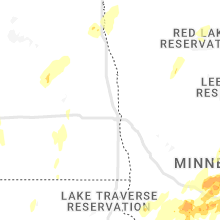
Wisconsin
| Local Time | Report Details |
|---|---|
| 1:17 PM CDT | Golf Ball sized hail reported near Grantsburg, WI, 62.2 miles NNE of Minneapolis, MN |
| 1:20 PM CDT | Hen Egg sized hail reported near Grantsburg, WI, 61.4 miles NNE of Minneapolis, MN |
| 1:22 PM CDT | Half Dollar sized hail reported near Grantsburg, WI, 62.2 miles NNE of Minneapolis, MN, report from mping: half dollar (1.25 in.). |
| 1:57 PM CDT | Quarter sized hail reported near Webster, WI, 58.7 miles S of Duluth, MN |
| 2:35 PM CDT | Quarter sized hail reported near Hatley, WI, 52.5 miles S of Rhinelander, WI, relayed by wsaw |
| 3:00 PM CDT | Ping Pong Ball sized hail reported near Mountain, WI, 51.5 miles NNW of Green Bay, WI, pictures via social media |
| 3:00 PM CDT | Quarter sized hail reported near Birnamwood, WI, 50.1 miles SSE of Rhinelander, WI, relayed by wsaw |
| 3:10 PM CDT | Half Dollar sized hail reported near Weyerhaeuser, WI, 95.8 miles ENE of Minneapolis, MN, time estimated by radar. |
| 3:20 PM CDT | Quarter sized hail reported near Bruce, WI, 91 miles W of Rhinelander, WI, time estimated by radar. |
| 3:29 PM CDT | Report from mping: 3-inch tree limb broke in price county WI, 53.6 miles WNW of Rhinelander, WI |
| 4:10 PM CDT | Quarter sized hail reported near Eagle River, WI, 20.3 miles NNE of Rhinelander, WI, via social media |
| 5:25 PM CDT | Quarter sized hail reported near Suring, WI, 37.4 miles NNW of Green Bay, WI |
| 6:50 PM CDT | Quarter sized hail reported near Oconto Falls, WI, 31.1 miles NNW of Green Bay, WI |
Kansas
| Local Time | Report Details |
|---|---|
| 1:19 PM CDT | Quarter sized hail reported near Lenora, KS, 57.6 miles NNW of Hays, KS, relayed from neighboring nws office from logan fire chief. |
| 1:19 PM CDT | Half Dollar sized hail reported near Logan, KS, 61.8 miles NNW of Hays, KS, facebook report of penny to half dollar hail. time estimated from radar. |
| 1:33 PM CDT | Quarter sized hail reported near Prairie View, KS, 67.4 miles N of Hays, KS, nickel to quarter size hail in prairie view. |
| 1:35 PM CDT | Ping Pong Ball sized hail reported near Prairie View, KS, 67.4 miles N of Hays, KS, report received via facebook. |
| 1:40 PM CDT | Asos station khlc hill cit in graham county KS, 43.6 miles NW of Hays, KS |
| 3:21 PM CDT | Storm damage reported in ellis county KS, 12.8 miles NE of Hays, KS |
| 5:10 PM CDT | Quarter sized hail reported near Hunter, KS, 58.7 miles ENE of Hays, KS |
| 5:30 PM CDT | Quarter sized hail reported near Quinter, KS, 49.8 miles W of Hays, KS, report of nickel to quarter hail. |
| 5:31 PM CDT | Quarter sized hail reported near Lincoln, KS, 64.7 miles E of Hays, KS |
| 5:31 PM CDT | Hen Egg sized hail reported near Lincoln, KS, 64.7 miles E of Hays, KS, kwch photo of 2 inch hail. |
| 6:26 PM CDT | Mesonet station up852 3.7 w ogallah (upr in trego county KS, 26.7 miles WNW of Hays, KS |
| 6:26 PM CDT | Quarter sized hail reported near Wakeeney, KS, 30.5 miles WNW of Hays, KS |
Nebraska
| Local Time | Report Details |
|---|---|
| 1:35 PM CDT | Report of flipped pivot just west of bertrand. time est from rada in gosper county NE, 72.2 miles SE of North Platte, NE |
| 1:40 PM CDT | Report received via facebook of overturned pivot south of lexington. time est from rada in dawson county NE, 61 miles ESE of North Platte, NE |
| 1:43 PM CDT | Estimated 55-60 mph wind gusts in lexington. report of at least one uprooted tre in dawson county NE, 58.9 miles ESE of North Platte, NE |
| 1:45 PM CDT | Photos via twitter show trees uprooted... fencing damage... and power poles bent over. time est. from rada in dawson county NE, 58.9 miles ESE of North Platte, NE |
| 1:47 PM CDT | Overton fd reported wind gusts of 70 mph. numerous tree limbs downed... some at least 6 inches in diameter. tree limbs are also in power lines. some trees have been upr in dawson county NE, 64.2 miles W of Grand Island, NE |
| 1:48 PM CDT | Storm damage reported in dawson county NE, 58.2 miles ESE of North Platte, NE |
| 1:56 PM CDT | Davis weatherlink statio in dawson county NE, 59.4 miles E of North Platte, NE |
| 2:00 PM CDT | Nebraska mesonet sit in phelps county NE, 62.3 miles WSW of Grand Island, NE |
| 2:15 PM CDT | Quarter sized hail reported near Gibbon, NE, 30.6 miles WSW of Grand Island, NE, dime to quarter size hail lasted from approx 215-223pm. accompanied by wind gusts of around 55 mph. |
| 2:26 PM CDT | Davis weatherlin in buffalo county NE, 40.4 miles WSW of Grand Island, NE |
| 2:26 PM CDT | Davis weatherlink statio in sherman county NE, 46.4 miles NW of Grand Island, NE |
| 2:26 PM CDT | Report via social media... winds at least 60 mph win in custer county NE, 55.7 miles WNW of Grand Island, NE |
| 2:28 PM CDT | Ping Pong Ball sized hail reported near Ansley, NE, 59.3 miles WNW of Grand Island, NE |
| 2:37 PM CDT | Davis weatherlin in sherman county NE, 40.5 miles NW of Grand Island, NE |
| 2:38 PM CDT | Davis weatherlin in valley county NE, 55 miles NW of Grand Island, NE |
| 2:40 PM CDT | Report via facebook. significant amount of blowing dus in hall county NE, 15.1 miles WNW of Grand Island, NE |
| 2:40 PM CDT | Davis weatherlin in valley county NE, 58.9 miles NW of Grand Island, NE |
| 2:41 PM CDT | Lots of trees down and estimated 80 mph wind in valley county NE, 54.7 miles NW of Grand Island, NE |
| 2:41 PM CDT | Storm damage reported in valley county NE, 56.8 miles NW of Grand Island, NE |
| 2:41 PM CDT | Have received reports via law enforcement and social media of widespread tree damage in ord. fencing and tin sheds also damage in valley county NE, 55.8 miles NNW of Grand Island, NE |
| 2:42 PM CDT | Nebraska mesonet site north of ord. time estimated from radar and nearby ob in valley county NE, 57.5 miles NNW of Grand Island, NE |
| 2:47 PM CDT | Ping Pong Ball sized hail reported near Cairo, NE, 19.5 miles WNW of Grand Island, NE, report received via facebook. time estimated from radar. |
| 2:53 PM CDT | Storm damage reported in garfield county NE, 54.8 miles SSW of Oneill, NE |
| 2:55 PM CDT | West side of town there was a horse barn 15 by 15 foot that was blown off. there were 25 trees uprooted. roof blown off the grand stand at the fairground in garfield county NE, 52.9 miles SSW of Oneill, NE |
| 3:01 PM CDT | Corrects time from am to pm from previous tstm wnd gst report from 7 nne wolbac in greeley county NE, 39 miles N of Grand Island, NE |
| 3:05 PM CDT | Estimated 60 mph wind gust with 12 inch diameter tree dow in garfield county NE, 37.5 miles SSW of Oneill, NE |
| 3:05 PM CDT | Quarter sized hail reported near Burwell, NE, 37.5 miles SSW of Oneill, NE |
| 3:07 PM CDT | Received report and photo via facebook of part of a metal roof peeled off a calving building approximately one-half mile east of spalding. time est from radar and nearb in greeley county NE, 52.8 miles N of Grand Island, NE |
| 3:12 PM CDT | From pws wl-primrose5.87n in boone county NE, 53.6 miles N of Grand Island, NE |
| 3:13 PM CDT | From pws wl-cedarrapids1.53nn in boone county NE, 46.2 miles NNE of Grand Island, NE |
| 3:15 PM CDT | Estimated 60 mph winds with half inch hai in boyd county NE, 44.6 miles NW of Oneill, NE |
| 3:18 PM CDT | Personal weather statio in boone county NE, 48.5 miles NNE of Grand Island, NE |
| 3:29 PM CDT | Measured 88 mph wind gust in holt county NE, 20.9 miles SE of Oneill, NE |
| 3:30 PM CDT | *** 1 inj *** delayed report of a semi truck rolled over by thunderstorm winds. motor vehicle injury occurre in holt county NE, 12.2 miles E of Oneill, NE |
| 3:35 PM CDT | Personal weather statio in antelope county NE, 26.6 miles SE of Oneill, NE |
| 3:38 PM CDT | Fertilizer plant destroye in antelope county NE, 43.9 miles SE of Oneill, NE |
| 3:40 PM CDT | Shingles blown of in madison county NE, 54.1 miles ESE of Oneill, NE |
| 3:42 PM CDT | Half Dollar sized hail reported near Meadow Grove, NE, 60.4 miles SE of Oneill, NE, accompanied by 60 mph gusts. |
| 3:42 PM CDT | Half Dollar sized hail reported near Meadow Grove, NE, 60.9 miles SE of Oneill, NE, also wind gust to 60mph. |
| 3:51 PM CDT | Horse barn and garage destroyed. report time based on rada in knox county NE, 34.5 miles NE of Oneill, NE |
| 3:53 PM CDT | Mesonet repor in madison county NE, 72 miles ESE of Oneill, NE |
| 3:54 PM CDT | Power poles down on highwa in madison county NE, 54.3 miles ESE of Oneill, NE |
| 3:56 PM CDT | Asos repor in madison county NE, 69.9 miles ESE of Oneill, NE |
| 4:00 PM CDT | Damage: large tree down on hous in madison county NE, 69 miles ESE of Oneill, NE |
| 4:00 PM CDT | Delayed report: garage destroyed. horse barn destoryed. time estimated by rada in knox county NE, 35.9 miles ENE of Oneill, NE |
| 4:00 PM CDT | Delayed report: three walls down and roof off of machine she in knox county NE, 33.1 miles ENE of Oneill, NE |
| 4:06 PM CDT | Large trees dow in knox county NE, 37.4 miles ENE of Oneill, NE |
| 4:10 PM CDT | Roof off of building in tow in wayne county NE, 75.7 miles E of Oneill, NE |
| 4:11 PM CDT | Storm damage reported in cedar county NE, 65.8 miles E of Oneill, NE |
| 4:14 PM CDT | Several reports of strong wind gusts of 70 to 80 mph near hartington and areas of southern cedar county. visibility very low due to dus in cedar county NE, 70.1 miles SSW of Sioux Falls, SD |
| 4:14 PM CDT | Trees uprooted or snapped; roof blown of in cedar county NE, 69.4 miles SSW of Sioux Falls, SD |
| 4:16 PM CDT | Roof off machine she in madison county NE, 61.9 miles ESE of Oneill, NE |
| 4:16 PM CDT | Large tree branches down... 6 to 7 inch in diameter. in addition power is ou in stanton county NE, 72 miles ESE of Oneill, NE |
| 4:17 PM CDT | Power lines down in red clou in webster county NE, 58.4 miles S of Grand Island, NE |
| 4:23 PM CDT | Report and photo via facebook of small outbuilding damage. time est. from rada in webster county NE, 52.4 miles S of Grand Island, NE |
| 4:25 PM CDT | Corrects previous tstm wnd dmg report from newcastle. multiple powerlines down across the city. multiple buildings also down along highway 12 near mile marker 219 and 2 in dixon county NE, 62.2 miles S of Sioux Falls, SD |
| 4:32 PM CDT | Corrects previous tstm wnd dmg report from ponca. multiple trees and powerlines dow in dixon county NE, 67.3 miles S of Sioux Falls, SD |
| 4:33 PM CDT | Report relayed via em of a power pole down near hwy 6 and 28 in adams county NE, 24.6 miles S of Grand Island, NE |
| 4:39 PM CDT | Half Dollar sized hail reported near Hastings, NE, 19.1 miles S of Grand Island, NE |
| 4:40 PM CDT | Quarter sized hail reported near Doniphan, NE, 15.6 miles S of Grand Island, NE, photo via facebook. |
| 4:40 PM CDT | Quarter sized hail reported near Glenvil, NE, 33.4 miles S of Grand Island, NE |
| 4:41 PM CDT | Golf Ball sized hail reported near Doniphan, NE, 15 miles S of Grand Island, NE |
| 4:45 PM CDT | Davis weatherlin in hall county NE, 12.9 miles S of Grand Island, NE |
| 4:46 PM CDT | Storm damage reported in york county NE, 39.5 miles ENE of Grand Island, NE |
| 4:47 PM CDT | Davis weatherlin in clay county NE, 38.2 miles SSE of Grand Island, NE |
| 4:48 PM CDT | Davis weatherlin in clay county NE, 34.9 miles SSE of Grand Island, NE |
| 4:49 PM CDT | Davis weatherlin in clay county NE, 41.8 miles SSE of Grand Island, NE |
| 4:50 PM CDT | Wind gusts estimated to be 65 to 70 mp in hamilton county NE, 16.8 miles SSE of Grand Island, NE |
| 4:50 PM CDT | Nebraska mesonet - time estimated from rada in clay county NE, 26.6 miles SSE of Grand Island, NE |
| 4:50 PM CDT | Storm damage reported in clay county NE, 38.9 miles SSE of Grand Island, NE |
| 4:52 PM CDT | Wind gusts estimated to be 70 mph. report of zero visibility in blowing dus in clay county NE, 36.1 miles SE of Grand Island, NE |
| 4:54 PM CDT | Report of a semi blown over on hwy 6 just west of the hwy 6 and 14 intersection north of clay center. a car was also blown off the road on hwy 6 near t roa in clay county NE, 28.5 miles SSE of Grand Island, NE |
| 4:57 PM CDT | Building damage and power poles broken in clay cente in clay county NE, 31.8 miles SSE of Grand Island, NE |
| 4:57 PM CDT | Elevator in clay center sustained damage... and a steel building on the southwest side of town wa destroyed. widespread power outages and tree damage across clay county in clay county NE, 31.2 miles SSE of Grand Island, NE |
| 5:00 PM CDT | Storm damage reported in clay county NE, 34.9 miles SSE of Grand Island, NE |
| 5:01 PM CDT | Report of multiple trucks blown over on interstate 80 around mm 326 and 329. near mm372 on south side of interstate 80 there are pivots flipped. time est. from rada in hamilton county NE, 14 miles ESE of Grand Island, NE |
| 5:04 PM CDT | Photo via twitter of a grain bin blown onto a rural road near the intersection of hwy 14 and road 5. time est. from rada in hamilton county NE, 21.1 miles ESE of Grand Island, NE |
| 5:05 PM CDT | Wind gusts measured at 65 mph at the interstate 80 and hwy 14 exit. report of vehicles blown ove in hamilton county NE, 19.2 miles ESE of Grand Island, NE |
| 5:08 PM CDT | Knehende in hamilton county NE, 27.8 miles ESE of Grand Island, NE |
| 5:10 PM CDT | Davis weatherlin in york county NE, 36.4 miles ESE of Grand Island, NE |
| 5:11 PM CDT | Davis weatherlin in hamilton county NE, 17.9 miles E of Grand Island, NE |
| 5:11 PM CDT | Storm damage reported in york county NE, 31 miles ESE of Grand Island, NE |
| 5:15 PM CDT | Storm damage reported in hamilton county NE, 18.5 miles E of Grand Island, NE |
| 5:16 PM CDT | Multiple powerlines down across the city. multiple buildings also down along highway 12 near mile marker 219 and 22 in dixon county NE, 62.2 miles S of Sioux Falls, SD |
| 5:20 PM CDT | Wind gusts estimated to be 75 to 80 mph at the interstate 80 and hwy 81 exit south of yor in york county NE, 39.4 miles E of Grand Island, NE |
| 5:20 PM CDT | Multiple trees and powerlines dow in dixon county NE, 67.3 miles S of Sioux Falls, SD |
| 5:22 PM CDT | Corrects previous tstm wnd gst report from polk davis weatherlink from 51 mph to 61 mp in polk county NE, 30.4 miles ENE of Grand Island, NE |
| 5:22 PM CDT | Knehende in york county NE, 31 miles ESE of Grand Island, NE |
| 5:25 PM CDT | Several branches down. a few hailstones up to nickel siz in york county NE, 39.4 miles E of Grand Island, NE |
| 5:30 PM CDT | Storm damage reported in york county NE, 49.4 miles E of Grand Island, NE |
| 5:30 PM CDT | Corrects time of previous tstm wnd gst report from 2 nne benedic in york county NE, 39.5 miles ENE of Grand Island, NE |
| 5:33 PM CDT | Storm damage reported in polk county NE, 44.6 miles ENE of Grand Island, NE |
| 5:38 PM CDT | Storm damage reported in york county NE, 35.6 miles E of Grand Island, NE |
| 5:54 PM CDT | Storm damage reported in platte county NE, 61.3 miles NE of Grand Island, NE |
| 5:55 PM CDT | Storm damage reported in platte county NE, 65.8 miles NE of Grand Island, NE |
| 5:59 PM CDT | Storm damage reported in thayer county NE, 53.7 miles SE of Grand Island, NE |
| 6:04 PM CDT | 1-inch tree limbs broken; shingles blown of in colfax county NE, 64.8 miles W of Omaha, NE |
| 6:06 PM CDT | Storm damage reported in thayer county NE, 52 miles SE of Grand Island, NE |
| 6:20 PM CDT | Tree branches dow in platte county NE, 74.2 miles NE of Grand Island, NE |
| 6:23 PM CDT | Report from mping: trees uprooted or snapped; roof blown of in cuming county NE, 54.3 miles NW of Omaha, NE |
| 6:31 PM CDT | Storm damage reported in dodge county NE, 38.2 miles WNW of Omaha, NE |
| 6:35 PM CDT | Awos station kahq waho in saunders county NE, 34.4 miles W of Omaha, NE |
| 6:35 PM CDT | Storm damage reported in saunders county NE, 35.6 miles W of Omaha, NE |
| 6:40 PM CDT | Storm damage reported in douglas county NE, 22.7 miles W of Omaha, NE |
| 6:40 PM CDT | Storm damage reported in burt county NE, 41.9 miles NNW of Omaha, NE |
| 6:45 PM CDT | Storm damage reported in fillmore county NE, 44.5 miles SE of Grand Island, NE |
| 6:49 PM CDT | Delayed report: roof off machine she in cuming county NE, 71.2 miles NW of Omaha, NE |
| 6:50 PM CDT | Delayed report: destroyed grain bin and damaged outbuilding in thurston county NE, 62.5 miles NNW of Omaha, NE |
| 6:52 PM CDT | Storm damage reported in burt county NE, 37.3 miles NNW of Omaha, NE |
| 6:54 PM CDT | Storm damage reported in burt county NE, 37.3 miles NNW of Omaha, NE |
| 6:55 PM CDT | Half Dollar sized hail reported near Plymouth, NE, 80.6 miles NNW of Manhattan, KS, time estimated from radar. |
| 7:00 PM CDT | Window blown out of hom in burt county NE, 54.3 miles NNW of Omaha, NE |
| 7:07 PM CDT | Tennis Ball sized hail reported near De Witt, NE, 78.5 miles SW of Omaha, NE |
| 7:16 PM CDT | Quarter sized hail reported near Clatonia, NE, 69.3 miles SW of Omaha, NE, also flipped a irrigation pivot. |
| 7:19 PM CDT | Golf Ball sized hail reported near Hallam, NE, 66.7 miles SW of Omaha, NE |
| 7:30 PM CDT | Storm damage reported in lancaster county NE, 61.2 miles SW of Omaha, NE |
| 7:32 PM CDT | Quarter sized hail reported near Cedar Bluffs, NE, 36.1 miles WNW of Omaha, NE |
| 7:36 PM CDT | Quarter sized hail reported near Lincoln, NE, 50.4 miles SW of Omaha, NE |
| 7:42 PM CDT | Golf Ball sized hail reported near Ceresco, NE, 41 miles WSW of Omaha, NE, time estimated from radar. |
| 7:45 PM CDT | Corrects previous tstm wnd dmg report from wakefield. multiple large trees dow in dixon county NE, 84.9 miles NNW of Omaha, NE |
| 7:45 PM CDT | Multiple large trees dow in dixon county NE, 84.6 miles NW of Omaha, NE |
| 7:48 PM CDT | Storm damage reported in adams county NE, 22.9 miles SSW of Grand Island, NE |
| 7:49 PM CDT | Quarter sized hail reported near Lincoln, NE, 46.3 miles SW of Omaha, NE |
| 7:55 PM CDT | Multiple trees and branches (3 inch in diameter) down. branch also reported down on a powerlin in dixon county NE, 78.6 miles S of Sioux Falls, SD |
| 7:58 PM CDT | Storm damage reported in saunders county NE, 26.2 miles SW of Omaha, NE |
| 8:47 PM CDT | Storm damage reported in burt county NE, 37.3 miles NNW of Omaha, NE |
| 9:39 PM CDT | Storm damage reported in lancaster county NE, 50.9 miles WSW of Omaha, NE |
South Dakota
| Local Time | Report Details |
|---|---|
| 1:45 PM MDT | Quarter sized hail reported near Spearfish, SD, 49.5 miles NW of Rapid City, SD, ground turning white with mostly dime-sized hail |
| 3:30 PM CDT | Multiple 3 inch branches dow in gregory county SD, 45.6 miles NNW of Oneill, NE |
| 3:45 PM CDT | Mesonet station fw5808 platt in charles mix county SD, 59.6 miles NNW of Oneill, NE |
| 4:01 PM CDT | Mesonet station 304 sd rwis corsic in douglas county SD, 64.8 miles N of Oneill, NE |
| 4:10 PM CDT | Trained spotter reports multiple branches (estimated 2 ft in diameter) on the groun in bon homme county SD, 47.2 miles NE of Oneill, NE |
| 4:12 PM CDT | Winds estimated 90-100 mph in tyndall. lots of tree and structural damage. county shed destroye in bon homme county SD, 54 miles NE of Oneill, NE |
| 4:15 PM CDT | An 80 foot by 200 foot building has only one wall standing. a 42 foot by 60 foot building has only one standing wall remaining. numerous trees uprooted. roofs off busin in charles mix county SD, 46.5 miles NNE of Oneill, NE |
| 4:15 PM CDT | Mesonet station wtes2 white lake (sd mesonet in aurora county SD, 87.9 miles N of Oneill, NE |
| 4:16 PM CDT | 12 vehicles flipped on i-90 between white lake and plankinto in aurora county SD, 86.5 miles N of Oneill, NE |
| 4:17 PM CDT | Very large trees uprooted around tow in aurora county SD, 86.9 miles N of Oneill, NE |
| 4:20 PM CDT | Massive damage to chicken bar in aurora county SD, 85.9 miles W of Sioux Falls, SD |
| 4:23 PM CDT | Storm damage reported in bon homme county SD, 58.2 miles WSW of Sioux Falls, SD |
| 4:23 PM CDT | Awos station kykn yankton municipal airpor in yankton county SD, 53.9 miles SW of Sioux Falls, SD |
| 4:25 PM CDT | Mesonet station 197 sd rwis gayvill in yankton county SD, 52.1 miles SSW of Sioux Falls, SD |
| 4:25 PM CDT | Report via social media of multiple 3-4 inch limbs dow in yankton county SD, 57.6 miles SW of Sioux Falls, SD |
| 4:25 PM CDT | Mesonet station 26 sd rwis trip in hutchinson county SD, 63.5 miles NNE of Oneill, NE |
| 4:27 PM CDT | Storm damage reported in yankton county SD, 56.1 miles SW of Sioux Falls, SD |
| 4:28 PM CDT | Semi blown ove in clay county SD, 52.3 miles SSW of Sioux Falls, SD |
| 4:28 PM CDT | Storm damage reported in hutchinson county SD, 63.5 miles NNE of Oneill, NE |
| 4:30 PM CDT | Report from mping: 3-inch tree limbs broken; power poles broke in clay county SD, 53.5 miles S of Sioux Falls, SD |
| 4:32 PM CDT | Mesonet station psts2 parkston (sd mesonet in hutchinson county SD, 64.3 miles W of Sioux Falls, SD |
| 4:32 PM CDT | Mesonet station fw9779 mitchel in davison county SD, 65.3 miles W of Sioux Falls, SD |
| 4:35 PM CDT | Mesonet station 163 sd rwis freema in hutchinson county SD, 39.2 miles WSW of Sioux Falls, SD |
| 4:37 PM CDT | Storm damage reported in union county SD, 59.8 miles S of Sioux Falls, SD |
| 4:40 PM CDT | Mesonet station bfms2 beresford 7 wsw (sd mesonet in clay county SD, 35.2 miles SSW of Sioux Falls, SD |
| 4:40 PM CDT | Multiple semi-trucks flipped between elk point and jefferso in union county SD, 63.5 miles S of Sioux Falls, SD |
| 4:40 PM CDT | Mesonet station 305 sd rwis lan in jerauld county SD, 93.3 miles WNW of Sioux Falls, SD |
| 4:42 PM CDT | Mesonet station bfms2 beresford 7 wsw (sd mesonet in clay county SD, 35.2 miles SSW of Sioux Falls, SD |
| 4:45 PM CDT | Mesonet station 53 sd rwis north sioux cit in union county SD, 68 miles W of Storm Lake, IA |
| 4:48 PM CDT | Farm equipment blown across the road and damage to farms/out-building in mccook county SD, 33.1 miles W of Sioux Falls, SD |
| 4:49 PM CDT | Mesonet station 213 sd rwis alexandri in hanson county SD, 49.8 miles W of Sioux Falls, SD |
| 4:53 PM CDT | Numerous trees were knocked down by the wind... blocking many streets. power is out at most places in town... especially the southwest par in turner county SD, 22.9 miles WSW of Sioux Falls, SD |
| 4:55 PM CDT | Report from mping: 1-inch tree limbs broken; shingles blown of in clay county SD, 53.7 miles S of Sioux Falls, SD |
| 4:55 PM CDT | Storm damage reported in mccook county SD, 34.1 miles WNW of Sioux Falls, SD |
| 4:56 PM CDT | Windows blown out and roof torn off of coffee cup fuel truck sto in minnehaha county SD, 11.9 miles WNW of Sioux Falls, SD |
| 4:57 PM CDT | Mesonet station 18 sd rwis montros in mccook county SD, 22.7 miles WNW of Sioux Falls, SD |
| 4:57 PM CDT | Storm damage reported in beadle county SD, 78.4 miles S of Aberdeen, SD |
| 5:00 PM CDT | Mesonet station sfws2 sioux falls 10 wsw (sd mesonet in minnehaha county SD, 10 miles WSW of Sioux Falls, SD |
| 5:00 PM CDT | Quarter sized hail reported near Huron, SD, 77 miles S of Aberdeen, SD |
| 5:00 PM CDT | Numerous pine trees have been uprooted by the wind. power is out across the southern part of tow in beadle county SD, 76.3 miles S of Aberdeen, SD |
| 5:01 PM CDT | Asos station khon huron regional airpor in beadle county SD, 74.9 miles S of Aberdeen, SD |
| 5:02 PM CDT | Tree down on hous in minnehaha county SD, 1.2 miles SSE of Sioux Falls, SD |
| 5:02 PM CDT | Mesonet station sfss2 sioux falls (sd mesonet in minnehaha county SD, 3.4 miles SSW of Sioux Falls, SD |
| 5:05 PM CDT | Mesonet station ctns2 colton 2 ese (sd mesonet in minnehaha county SD, 17.4 miles NNW of Sioux Falls, SD |
| 5:05 PM CDT | Mesonet station btcs2 baltic 3 se (sd mesonet in minnehaha county SD, 13 miles NNE of Sioux Falls, SD |
| 5:06 PM CDT | Report from mping: 3-inch tree limbs broken; power poles broke in union county SD, 60.5 miles S of Sioux Falls, SD |
| 5:09 PM CDT | Awos station kmds madison airpor in lake county SD, 37.1 miles NNW of Sioux Falls, SD |
| 5:09 PM CDT | Trees down and damage to outbuilding at high schoo in minnehaha county SD, 19 miles N of Sioux Falls, SD |
| 5:10 PM CDT | Storm damage reported in beadle county SD, 70.7 miles SSE of Aberdeen, SD |
| 5:12 PM CDT | 5 large trees down and roof blown off of bar in lake county SD, 43.1 miles NNW of Sioux Falls, SD |
| 5:12 PM CDT | Report from mping: 3-inch tree limbs broken; power poles broke in minnehaha county SD, 1.8 miles SSW of Sioux Falls, SD |
| 5:15 PM CDT | Storm damage reported in lake county SD, 32.5 miles NNW of Sioux Falls, SD |
| 5:15 PM CDT | Mesonet station 211 sd rwis cavou in beadle county SD, 79.2 miles SSE of Aberdeen, SD |
| 5:15 PM CDT | Large and mature trees bent over 30 degrees. winds estimated 65 mp in moody county SD, 40.3 miles N of Sioux Falls, SD |
| 5:16 PM CDT | Storm damage reported in lake county SD, 41.1 miles NNW of Sioux Falls, SD |
| 5:18 PM CDT | Quarter sized hail reported near Faulkton, SD, 43.1 miles SW of Aberdeen, SD, report from mping: quarter (1.00 in.). |
| 5:21 PM CDT | Mesonet station 284 jct sd28/sd37 (sddot in spink county SD, 58.7 miles SSE of Aberdeen, SD |
| 5:22 PM CDT | Storm damage reported in hamlin county SD, 75.3 miles NNW of Sioux Falls, SD |
| 5:22 PM CDT | Structure damag in hamlin county SD, 70.2 miles WSW of Montevideo, MN |
| 5:23 PM CDT | 7 to 8 power poles snappe in kingsbury county SD, 64.4 miles NNW of Sioux Falls, SD |
| 5:23 PM CDT | Barn destroyed with debris thrown across highway 1 in kingsbury county SD, 61.5 miles NNW of Sioux Falls, SD |
| 5:24 PM CDT | Mesonet station vgas2 volga (sd mesonet in brookings county SD, 52.9 miles N of Sioux Falls, SD |
| 5:25 PM CDT | 2 grain silo tops ripped off and bent in... portions of roofs peeled off downtown... and multiple trees down across the cit in kingsbury county SD, 59.7 miles NNW of Sioux Falls, SD |
| 5:26 PM CDT | Numerous vehicles knocked over and trees snapped. widespread damage to houses and roof in brookings county SD, 52.9 miles N of Sioux Falls, SD |
| 5:26 PM CDT | Awos station kbkx brookings municipal airpor in brookings county SD, 50.9 miles N of Sioux Falls, SD |
| 5:30 PM CDT | Mesonet station vgas2 volga (sd mesonet in brookings county SD, 52.9 miles N of Sioux Falls, SD |
| 5:36 PM CDT | Mesonet station 262 sd rwis bryant se corner sd25/sd2 in clark county SD, 75.6 miles SE of Aberdeen, SD |
| 5:40 PM CDT | Mesonet station oaks2 astoria 4 sse (sd mesonet in brookings county SD, 50.3 miles SW of Montevideo, MN |
| 5:45 PM CDT | Storm damage reported in spink county SD, 52.4 miles SSE of Aberdeen, SD |
| 5:45 PM CDT | Radar estimated time; 1 mile of powerlines snappe in hamlin county SD, 69.9 miles WSW of Montevideo, MN |
| 5:48 PM CDT | Damage to building in hamlin county SD, 63.6 miles WSW of Montevideo, MN |
| 5:50 PM CDT | Ambient weather station. nearby report of tree dow in deuel county SD, 41.2 miles WSW of Montevideo, MN |
| 5:51 PM CDT | Storm damage reported in spink county SD, 51.3 miles SSE of Aberdeen, SD |
| 5:51 PM CDT | Trees down... houses with lots of damag in deuel county SD, 49.1 miles WSW of Montevideo, MN |
| 5:52 PM CDT | Roof and tree damage. uprooted tree in hamlin county SD, 63.9 miles WSW of Montevideo, MN |
| 5:55 PM CDT | Time estimated; trees and powerlines dow in codington county SD, 71.2 miles W of Montevideo, MN |
| 6:00 PM CDT | Storm damage reported in codington county SD, 66 miles W of Montevideo, MN |
| 6:00 PM CDT | Time estimated; house ripped apar in codington county SD, 69.6 miles ESE of Aberdeen, SD |
| 6:02 PM CDT | Asos station katy watertown muni a in codington county SD, 70.4 miles W of Montevideo, MN |
| 6:04 PM CDT | Branches and trees dow in deuel county SD, 48.9 miles WSW of Montevideo, MN |
| 6:05 PM CDT | House and shed damage... turned over semitruc in deuel county SD, 38.3 miles WSW of Montevideo, MN |
| 6:07 PM CDT | Storm damage reported in deuel county SD, 37.9 miles WSW of Montevideo, MN |
| 6:09 PM CDT | Estimated tim in spink county SD, 31.8 miles SSE of Aberdeen, SD |
| 6:11 PM CDT | Buildings damage in codington county SD, 69.4 miles W of Montevideo, MN |
| 6:11 PM CDT | Time estimated mping report... 1-inch tree limb broken; shingles blown of in codington county SD, 64.6 miles W of Montevideo, MN |
| 6:13 PM CDT | Storm damage reported in codington county SD, 67.4 miles W of Montevideo, MN |
| 6:15 PM CDT | Storm damage reported in day county SD, 51.2 miles ESE of Aberdeen, SD |
| 6:15 PM CDT | Mesonet station shss2 south shore 8 w (sd mesonet in codington county SD, 68.6 miles W of Montevideo, MN |
| 6:20 PM CDT | Mesonet station webs2 webster 3 s (sd mesonet in day county SD, 48.5 miles ESE of Aberdeen, SD |
| 6:27 PM CDT | Roof taken off a building in downtown big stone cit in grant county SD, 43.5 miles NW of Montevideo, MN |
| 6:27 PM CDT | Uprooted tree in ortley. report via social media. time estimated via rada in roberts county SD, 63.2 miles E of Aberdeen, SD |
| 6:28 PM CDT | Storm damage reported in roberts county SD, 53.6 miles WNW of Montevideo, MN |
| 6:30 PM CDT | Storm damage reported in day county SD, 34.4 miles E of Aberdeen, SD |
| 6:31 PM CDT | Mesonet station 182 waubay (sddot in day county SD, 54 miles E of Aberdeen, SD |
| 6:36 PM CDT | Mesonet station 55 summit (sddot in roberts county SD, 69.7 miles WNW of Montevideo, MN |
| 6:40 PM CDT | Storm damage reported in brown county SD, 18.8 miles E of Aberdeen, SD |
| 6:41 PM CDT | Storm damage reported in roberts county SD, 59 miles WNW of Montevideo, MN |
| 6:45 PM CDT | Storm damage reported in marshall county SD, 33.4 miles ENE of Aberdeen, SD |
| 6:56 PM CDT | Awos station k8d3 2 e sisseto in roberts county SD, 73.6 miles ENE of Aberdeen, SD |
| 6:56 PM CDT | Downed trees across town. time estimated by rada in roberts county SD, 69.5 miles S of Fargo, ND |
| 6:59 PM CDT | Mesonet station mrls2 hillhead 3 ws in marshall county SD, 55.5 miles ENE of Aberdeen, SD |
| 7:13 PM CDT | Mesonet station 53 sd rwis north sioux cit in union county SD, 68 miles W of Storm Lake, IA |
| 7:20 PM CDT | Quarter sized hail reported near Vermillion, SD, 53.7 miles S of Sioux Falls, SD, report from mping: quarter (1.00 in.). |
| 7:24 PM CDT | Also report pea size hai in union county SD, 65.3 miles S of Sioux Falls, SD |
| 7:25 PM CDT | Quarter sized hail reported near Vermillion, SD, 53.7 miles S of Sioux Falls, SD, report from mping: quarter (1.00 in.). |
| 7:34 PM CDT | Mesonet station 16 sd rwis beresfor in union county SD, 35.1 miles S of Sioux Falls, SD |
| 7:41 PM CDT | Mesonet station 176 sd rwis davi in lincoln county SD, 20 miles S of Sioux Falls, SD |
Michigan
| Local Time | Report Details |
|---|---|
| 3:47 PM CDT | Quarter sized hail reported near Felch, MI, 42.9 miles SSW of Marquette, MI, corrects previous hail report from 1 wnw felch. picture via facebook showing hail estimated to be the size of a quarter (coin). |
| 5:19 PM CDT | Asos station kimt kingsfor in dickinson county MI, 60.5 miles SW of Marquette, MI |
Texas
| Local Time | Report Details |
|---|---|
| 4:55 PM CDT | Quarter sized hail reported near , , 66.6 miles ENE of Alpine, TX, hail observed along us285 se of fort stockton. |
| 5:34 PM CDT | Quarter sized hail reported near Fort Stockton, TX, 67.2 miles ENE of Alpine, TX, hail observed along us285 se of fort stockton. time estimated from radar. |
Mississippi
| Local Time | Report Details |
|---|---|
| 4:56 PM CDT | A tree was blown down along highway 532 and broomfield lan in covington county MS, 59 miles SE of Jackson, MS |
| 5:12 PM CDT | A tree fell onto a power line along gene monk roa in covington county MS, 58.4 miles SE of Jackson, MS |
| 6:10 PM CDT | A few small trees were blown down along highway 13 and ella walker roa in simpson county MS, 36.2 miles SSE of Jackson, MS |
| 6:20 PM CDT | Tree down on cutoff road near sebastapoo in scott county MS, 51 miles ENE of Jackson, MS |
| 6:40 PM CDT | Tree down on old highway 80 near lak in scott county MS, 46.7 miles E of Jackson, MS |
| 7:05 PM CDT | Trees were blown down along highway 2 in rankin county MS, 23.3 miles NE of Jackson, MS |
| 7:10 PM CDT | Tree down on kracker station roa in scott county MS, 29.9 miles E of Jackson, MS |
| 7:53 PM CDT | A tree fell onto a house along highway 43 sout in rankin county MS, 26.7 miles ESE of Jackson, MS |
Iowa
| Local Time | Report Details |
|---|---|
| 5:00 PM CDT | Large branches and power lines dow in woodbury county IA, 62.9 miles W of Storm Lake, IA |
| 5:30 PM CDT | Awos station kshl sheldon airpor in o'brien county IA, 50.5 miles NW of Storm Lake, IA |
| 5:35 PM CDT | Zero visibility due to strong winds and dust storm for the last 10 minute in lyon county IA, 43.5 miles E of Sioux Falls, SD |
| 6:13 PM CDT | Report from mping: homes/buildings completely destroye in sioux county IA, 32.9 miles SE of Sioux Falls, SD |
| 7:05 PM CDT | Visibility from dust down to 2 miles. dime sized hai in harrison county IA, 39.6 miles N of Omaha, NE |
| 7:09 PM CDT | Asos station ksux sioux gateway airpor in woodbury county IA, 63 miles WSW of Storm Lake, IA |
| 7:17 PM CDT | Report from mping: 1-inch tree limbs broken; shingles blown of in monona county IA, 61.6 miles NNW of Omaha, NE |
| 7:30 PM CDT | Machine shed blown over and 2 trees (6-8 inch in diameter) snappe in plymouth county IA, 37.6 miles W of Storm Lake, IA |
| 7:49 PM CDT | Awos station kslb storm lake airpor in buena vista county IA, 3.4 miles SSW of Storm Lake, IA |
| 7:49 PM CDT | Report from mping: 3-inch tree limbs broken; power poles broke in monona county IA, 60.3 miles N of Omaha, NE |
| 7:51 PM CDT | Trees uprooted or snappe in monona county IA, 60.3 miles N of Omaha, NE |
| 7:56 PM CDT | Storm damage reported in lyon county IA, 17.1 miles ESE of Sioux Falls, SD |
| 8:00 PM CDT | Significant roof damage to large machine she in o'brien county IA, 34.2 miles NW of Storm Lake, IA |
| 8:24 PM CDT | Storm damage reported in clay county IA, 34.8 miles N of Storm Lake, IA |
| 8:40 PM CDT | Medium size tree branch down in graettinger. report from social medi in palo alto county IA, 46.6 miles NNE of Storm Lake, IA |
North Dakota
| Local Time | Report Details |
|---|---|
| 4:15 PM MDT | Quarter sized hail reported near Hazen, ND, 54.2 miles NW of Bismarck, ND, photo of penny to quarter size hail at hazen 2w ndawn mesonet. |
| 5:54 PM CDT | Ping Pong Ball sized hail reported near Garrison, ND, 40.9 miles S of Minot, ND, relayed via photo from broadcast media. |
| 6:42 PM CDT | Gust at 10m... courtesy of ndaw in grand forks county ND, 72.5 miles E of Devils Lake, ND |
| 7:11 PM CDT | Quarter sized hail reported near Valley City, ND, 58.3 miles W of Fargo, ND, report from mping: quarter (1.00 in.). |
| 7:16 PM CDT | Personal weather station reports 78mph wind gus in richland county ND, 58.7 miles S of Fargo, ND |
| 7:25 PM CDT | Roof damage with missing shingles and a large hole in the roo in richland county ND, 42.6 miles S of Fargo, ND |
| 7:30 PM CDT | Trained spotter reports 1-2ft diameter trees down... roof damage in wahpeton. time estimate in richland county ND, 42.6 miles S of Fargo, ND |
| 7:34 PM CDT | Mooreton ndawn gust at 10m. courtesy of ndaw in richland county ND, 44.4 miles S of Fargo, ND |
| 7:35 PM CDT | 10m wind gus in richland county ND, 44.7 miles S of Fargo, ND |
Alabama
| Local Time | Report Details |
|---|---|
| 5:55 PM CDT | Quarter sized hail reported near Wilmer, AL, 20.4 miles WNW of Mobile, AL, social media post showed quarter sized hail. time estimated by radar. |
Louisiana
| Local Time | Report Details |
|---|---|
| 9:05 PM CDT | Reports of trees... sheds... carports... and fences down near the intersection of la-63 and la-1019 and rafe ballard rd. multiple reports of power outages near watso in livingston county LA, 64.2 miles NW of New Orleans, LA |
| 9:05 PM CDT | Corrects previous tstm wnd dmg report from 7 ene watson. reports of trees... sheds... carports... and fences down near the intersection of la-63 and la-1019 and rafe ba in livingston county LA, 64.2 miles NW of New Orleans, LA |
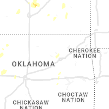
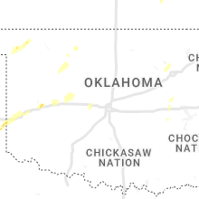
Oklahoma
| Local Time | Report Details |
|---|---|
| 9:44 PM CDT | Quarter sized hail reported near May, OK, 23.4 miles WNW of Woodward, OK |
| 10:24 PM CDT | Quarter sized hail reported near Woodward, OK, 17.7 miles N of Woodward, OK |
Connect with Interactive Hail Maps