

Hail Map for Wednesday, May 30, 2012

Number of Impacted Households on 5/30/2012
0
Impacted by 1" or Larger Hail
0
Impacted by 1.75" or Larger Hail
0
Impacted by 2.5" or Larger Hail
Square Miles of Populated Area Impacted on 5/30/2012
0
Impacted by 1" or Larger Hail
0
Impacted by 1.75" or Larger Hail
0
Impacted by 2.5" or Larger Hail


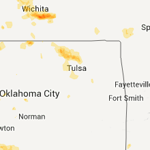


Cities Most Affected by Hail Storms of 5/30/2012
| Hail Size | Demographics of Zip Codes Affected | ||||||
|---|---|---|---|---|---|---|---|
| City | Count | Average | Largest | Pop Density | House Value | Income | Age |
| Paducah, TX | 8 | 3.28 | 4.50 | 0 | $26k | $24.6k | 46.5 |
| Wichita, KS | 9 | 1.83 | 2.00 | 2451 | $87k | $42.7k | 33.1 |
| Hays, KS | 5 | 2.05 | 2.75 | 62 | $91k | $32.5k | 30.5 |
| Alexander, KS | 4 | 2.19 | 2.50 | 1 | $30k | $13.1k | 52.9 |
| Seymour, TX | 3 | 2.42 | 2.75 | 4 | $34k | $24.5k | 47.1 |
| Melvin, TX | 3 | 2.42 | 2.75 | 1 | $24k | $17.2k | 52.0 |
| Millersview, TX | 2 | 3.38 | 4.00 | 1 | $75k | $33.3k | 61.2 |
| Tuscola, TX | 3 | 2.08 | 2.75 | 31 | $76k | $46.7k | 41.0 |
| Ballinger, TX | 3 | 2.08 | 2.75 | 15 | $42k | $26.9k | 42.5 |
| Victoria, KS | 3 | 2.00 | 2.50 | 8 | $70k | $33.5k | 42.6 |
| Memphis, TX | 1 | 3.00 | 3.00 | 8 | $30k | $23.0k | 42.0 |
| Paint Rock, TX | 1 | 2.75 | 2.75 | 1 | $58k | $34.1k | 48.5 |
| Pampa, TX | 1 | 2.75 | 2.75 | 41 | $38k | $31.6k | 38.4 |
| Brady, TX | 1 | 2.50 | 2.50 | 13 | $34k | $25.3k | 41.7 |
| Sylvan Grove, KS | 1 | 2.00 | 2.00 | 3 | $37k | $28.9k | 48.4 |
| Mcpherson, KS | 1 | 2.00 | 2.00 | 67 | $86k | $42.0k | 39.9 |
| Cleburne, TX | 1 | 1.75 | 1.75 | 156 | $0k | $0.0k | 36.8 |
| Lawn, TX | 1 | 1.75 | 1.75 | 10 | $34k | $32.8k | 46.6 |
| Brewster, KS | 1 | 1.75 | 1.75 | 1 | $42k | $36.6k | 43.3 |
| Russell, KS | 1 | 1.75 | 1.75 | 15 | $46k | $30.2k | 45.3 |
| Scott City, KS | 1 | 1.75 | 1.75 | 6 | $72k | $40.5k | 41.5 |
| Hoisington, KS | 1 | 1.75 | 1.75 | 15 | $43k | $29.3k | 41.7 |
| Andover, KS | 1 | 1.75 | 1.75 | 382 | $124k | $58.4k | 34.8 |
| Estelline, TX | 1 | 1.75 | 1.75 | 0 | $20k | $21.9k | 40.5 |
| Gorham, KS | 1 | 1.75 | 1.75 | 1 | $40k | $25.0k | 41.7 |
| Bertrand, NE | 1 | 1.75 | 1.75 | 7 | $63k | $37.1k | 45.2 |
| Colby, KS | 1 | 1.75 | 1.75 | 13 | $79k | $37.3k | 35.7 |
| Hutchinson, KS | 1 | 1.75 | 1.75 | 297 | $94k | $45.1k | 46.4 |
| Mount Hope, KS | 1 | 1.75 | 1.75 | 18 | $77k | $46.5k | 39.9 |
| Merkel, TX | 1 | 1.75 | 1.75 | 15 | $42k | $32.0k | 40.5 |
| Augusta, KS | 1 | 1.75 | 1.75 | 132 | $84k | $46.3k | 38.4 |
| Nekoma, KS | 1 | 1.75 | 1.75 | 1 | $13k | $25.8k | 51.0 |
| Dickens, NE | 1 | 1.75 | 1.75 | 1 | $95k | $50.4k | 38.5 |
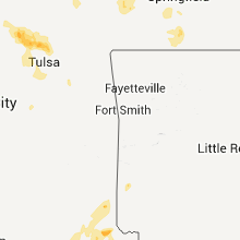
Hail and Wind Damage Spotted on 5/30/2012
Filter by Report Type:Hail ReportsWind Reports
States Impacted
Oklahoma, Texas, Nebraska, Arkansas, New York, Mississippi, Alabama, Florida, Kansas, LouisianaOklahoma
| Local Time | Report Details |
|---|---|
| 7:00 AM CDT | Half Dollar sized hail reported near Bethany, OK, 7.2 miles WNW of Oklahoma City, OK, time estimated |
| 7:02 PM CDT | Ping Pong Ball sized hail reported near Calumet, OK, 46.9 miles WNW of Oklahoma City, OK |
| 7:15 PM CDT | Storm damage reported in cotton county OK, 25.1 miles N of Wichita Falls, TX |
| 7:15 PM CDT | Storm damage reported in cotton county OK, 25.1 miles N of Wichita Falls, TX |
| 8:00 PM CDT | Storm damage reported in jefferson county OK, 38.1 miles ENE of Wichita Falls, TX |
| 8:12 PM CDT | Quarter sized hail reported near Gate, OK, 59.3 miles NW of Woodward, OK |
| 8:58 PM CDT | Storm damage reported in love county OK, 55.6 miles E of Wichita Falls, TX |
| 9:30 PM CDT | Storm damage reported in harper county OK, 29.8 miles NNW of Woodward, OK |
| 9:30 PM CDT | Widespread damage across the town. up to three foot diameter tree limbs downed. most of the town without electricity. reported by alfalfa county emergmg in alfalfa county OK, 53.2 miles E of Woodward, OK |
| 9:35 PM CDT | Storm damage reported in harper county OK, 29.8 miles NNW of Woodward, OK |
| 9:45 PM CDT | Storm damage reported in woods county OK, 46.7 miles ENE of Woodward, OK |
| 9:45 PM CDT | Storm damage reported in woods county OK, 42.3 miles ENE of Woodward, OK |
| 9:47 PM CDT | Storm damage reported in kay county OK, 57.7 miles SSE of Wichita, KS |
| 10:07 PM CDT | Power poles blown down. reported by harper county emergency mg in harper county OK, 28.9 miles NNW of Woodward, OK |
| 10:40 PM CDT | Storm damage reported in dewey county OK, 43.9 miles SSE of Woodward, OK |
| 10:51 PM CDT | Storm damage reported in carter county OK, 60.2 miles W of Atoka, OK |
| 10:53 PM CDT | Storm damage reported in carter county OK, 60.2 miles W of Atoka, OK |
| 10:55 PM CDT | Storm damage reported in garfield county OK, 63.5 miles NNW of Oklahoma City, OK |
| 11:00 PM CDT | Storm damage reported in kingfisher county OK, 41.7 miles WNW of Oklahoma City, OK |
| 11:03 PM CDT | Media estimated 60 mph winds near pershin in osage county OK, 34.3 miles NNW of Tulsa, OK |
| 11:05 PM CDT | Spotter reported thunderstorm wind gust to 60 mph. branches downed by wind in osage county OK, 63.2 miles NW of Tulsa, OK |
| 11:10 PM CDT | Storm damage reported in custer county OK, 70.5 miles W of Oklahoma City, OK |
| 11:25 PM CDT | Storm damage reported in canadian county OK, 29.9 miles WNW of Oklahoma City, OK |
| 11:30 PM CDT | Large tree down over road in washington county OK, 41.4 miles N of Tulsa, OK |
| 11:32 PM CDT | Large tree down over road in washington county OK, 44.9 miles N of Tulsa, OK |
| 11:40 PM CDT | Estimated 60 mph wind gust and quarter size hail. relayed through medi in washington county OK, 31.1 miles N of Tulsa, OK |
| 11:40 PM CDT | Storm damage reported in grady county OK, 27.8 miles WSW of Oklahoma City, OK |
| 11:49 PM CDT | Storm damage reported in canadian county OK, 13.2 miles WNW of Oklahoma City, OK |
| 11:50 PM CDT | Large dumpster blown over and moved about 1/2 bloc in rogers county OK, 22.1 miles NNE of Tulsa, OK |
| 11:54 PM CDT | Storm damage reported in oklahoma county OK, 7.2 miles SW of Oklahoma City, OK |
| 11:55 PM CDT | Trees and power lines down on west side of hominy in osage county OK, 28.5 miles NW of Tulsa, OK |
| 11:55 PM CDT | Several large limbs dow in rogers county OK, 28.9 miles NNE of Tulsa, OK |
| 12:00 AM CDT | Storm damage reported in grady county OK, 41.1 miles SW of Oklahoma City, OK |
| 12:35 AM CDT | Tree down near 61st and trento in tulsa county OK, 4.3 miles ESE of Tulsa, OK |
| 12:41 AM CDT | Storm damage reported in tulsa county OK, 10.4 miles N of Tulsa, OK |
| 12:50 AM CDT | Large tree limbs down in rogers county OK, 15.5 miles NE of Tulsa, OK |
Texas
| Local Time | Report Details |
|---|---|
| 7:00 AM CDT | Golf Ball sized hail reported near Cleburne, TX, 46 miles SW of Dallas, TX, ping pong to golfball size hail reported in and west of cleburne |
| 10:40 AM CDT | Quarter sized hail reported near Aubrey, TX, 35.7 miles NNW of Dallas, TX, dime to quarter sized hail fell for several minutes at the intersection of hwy 377 and industrial park |
| 3:17 PM CDT | Ping Pong Ball sized hail reported near Aubrey, TX, 31.8 miles NNW of Dallas, TX, along hwy 380 between crossroads and prosper |
| 3:58 PM CDT | Golf Ball sized hail reported near Hedley, TX, 34.7 miles NW of Childress, TX |
| 4:00 PM CDT | Quarter sized hail reported near Memphis, TX, 39.7 miles NW of Childress, TX |
| 4:00 PM CDT | Hen Egg sized hail reported near Hedley, TX, 40.8 miles NW of Childress, TX |
| 4:01 PM CDT | Quarter sized hail reported near Hedley, TX, 35.7 miles NW of Childress, TX |
| 4:12 PM CDT | Baseball sized hail reported near Pampa, TX, 60.8 miles ENE of Amarillo, TX |
| 4:25 PM CDT | Barns damaged...power lines down...home with roof removed...trailers blown over. no injurie in hall county TX, 26.4 miles NW of Childress, TX |
| 4:36 PM CDT | Tea Cup sized hail reported near Memphis, TX, 19.3 miles NW of Childress, TX |
| 4:50 PM CDT | Ping Pong Ball sized hail reported near Clarendon, TX, 54.6 miles NNW of Childress, TX |
| 4:55 PM CDT | Quarter sized hail reported near Pampa, TX, 71.9 miles ENE of Amarillo, TX |
| 5:10 PM CDT | Quarter sized hail reported near Wellington, TX, 41.6 miles NNW of Childress, TX, nickel to quarter size hail falling. |
| 5:20 PM CDT | Golf Ball sized hail reported near Estelline, TX, 14.6 miles WNW of Childress, TX, reported on highway 287 near the hall and childress county line |
| 5:22 PM CDT | Quarter sized hail reported near Paducah, TX, 21.3 miles SSW of Childress, TX, quarter size hail along highway 83 north of paducah |
| 5:27 PM CDT | Softball sized hail reported near Paducah, TX, 17.3 miles SSW of Childress, TX |
| 5:28 PM CDT | Baseball sized hail reported near Tuscola, TX, 20 miles SW of Abilene, TX, quarter to baseball size hail at coronado camp at the junction of us 277 and rural road 89 |
| 5:31 PM CDT | Golf Ball sized hail reported near Merkel, TX, 21 miles SW of Abilene, TX |
| 5:40 PM CDT | Baseball sized hail reported near Paducah, TX, 23.4 miles S of Childress, TX |
| 5:42 PM CDT | Quarter sized hail reported near Childress, TX, 5.3 miles WSW of Childress, TX, hail reported at prison southwest of childress |
| 5:49 PM CDT | Softball sized hail reported near Paducah, TX, 24.1 miles S of Childress, TX |
| 5:58 PM CDT | Golf Ball sized hail reported near Paducah, TX, 10.5 miles SSW of Childress, TX |
| 5:59 PM CDT | Estimated 80-90 mph winds in paducah. power is out and several reports of trees dow in cottle county TX, 29.4 miles S of Childress, TX |
| 5:59 PM CDT | Reports of full trees uprooted...sheet metal flying through air...possible combination straight line winds and gustnado in cottle county TX, 29.4 miles S of Childress, TX |
| 6:00 PM CDT | Golf Ball sized hail reported near Tuscola, TX, 16.5 miles SSW of Abilene, TX, golf ball size hail at abilene state park |
| 6:00 PM CDT | Golf Ball sized hail reported near Ballinger, TX, 50.5 miles SSW of Abilene, TX, report relayed through local broadcast media |
| 6:05 PM CDT | Baseball sized hail reported near Ballinger, TX, 50.5 miles SSW of Abilene, TX |
| 6:08 PM CDT | Golf Ball sized hail reported near Ballinger, TX, 50.5 miles SSW of Abilene, TX |
| 6:10 PM CDT | Quarter sized hail reported near Tuscola, TX, 16.8 miles SSW of Abilene, TX, pea to quarter size hail in town |
| 6:25 PM CDT | Golf Ball sized hail reported near Tuscola, TX, 16.8 miles SSW of Abilene, TX |
| 6:27 PM CDT | Golf Ball sized hail reported near Lawn, TX, 19.3 miles S of Abilene, TX |
| 6:27 PM CDT | Storm damage reported in knox county TX, 51.2 miles SSE of Childress, TX |
| 6:33 PM CDT | Quarter sized hail reported near Lawn, TX, 22 miles S of Abilene, TX, dime to quarter size hail near lawn |
| 6:50 PM CDT | Storm damage reported in knox county TX, 51.2 miles SSE of Childress, TX |
| 6:56 PM CDT | Storm damage reported in concho county TX, 65.8 miles S of Abilene, TX |
| 7:00 PM CDT | Baseball sized hail reported near Paint Rock, TX, 63.3 miles S of Abilene, TX, nickel to baseball size hail near the rural road 1929 bridge |
| 7:15 PM CDT | West texas mesonet station in cottle county TX, 37.9 miles SSW of Childress, TX |
| 7:17 PM CDT | Baseball sized hail reported near Millersview, TX, 71.6 miles S of Abilene, TX |
| 7:20 PM CDT | Baseball sized hail reported near Paducah, TX, 30.7 miles SSW of Childress, TX |
| 7:20 PM CDT | Several road signs blown over in the millersview are in concho county TX, 71.6 miles S of Abilene, TX |
| 7:24 PM CDT | Baseball sized hail reported near Seymour, TX, 51.2 miles SSE of Childress, TX |
| 7:26 PM CDT | Baseball sized hail reported near Paducah, TX, 34.4 miles SSW of Childress, TX |
| 7:30 PM CDT | Grapefruit sized hail reported near Millersview, TX, 71.6 miles S of Abilene, TX, broken skylights and limbs 1-2 inches healthy pecan tree. |
| 7:30 PM CDT | West texas mesonet station in cottle county TX, 37.9 miles SSW of Childress, TX |
| 7:32 PM CDT | Baseball sized hail reported near Paducah, TX, 38.9 miles S of Childress, TX |
| 7:40 PM CDT | Softball sized hail reported near Paducah, TX, 38.9 miles S of Childress, TX |
| 7:43 PM CDT | Baseball sized hail reported near Paducah, TX, 43 miles S of Childress, TX, golfball to baseball size hail falling |
| 7:46 PM CDT | Storm damage reported in wichita county TX, 4.9 miles N of Wichita Falls, TX |
| 7:55 PM CDT | Golf Ball sized hail reported near Paducah, TX, 55.5 miles S of Childress, TX, also reports of very strong winds but no speed estimate |
| 8:05 PM CDT | Golf Ball sized hail reported near Melvin, TX, 86.6 miles S of Abilene, TX, wall cloud observed in addition to golf ball size hail |
| 8:10 PM CDT | Storm damage reported in baylor county TX, 60.5 miles WSW of Wichita Falls, TX |
| 8:10 PM CDT | Golf Ball sized hail reported near Seymour, TX, 60.5 miles WSW of Wichita Falls, TX |
| 8:19 PM CDT | Ping Pong Ball sized hail reported near Paducah, TX, 55.8 miles S of Childress, TX, located along highway 82 east of the intersection with state highway 222 |
| 8:30 PM CDT | Roof damage was sustained at at least one residence near melvin. damage occurred just east of ranch road 2028 approximately 3 mile south of melvi in mcculloch county TX, 90 miles S of Abilene, TX |
| 8:30 PM CDT | Baseball sized hail reported near Melvin, TX, 86.6 miles S of Abilene, TX, wind driven baseball size hail produced extensive damage in melvin. east facing windows were all blown in on several residences |
| 8:30 PM CDT | Baseball sized hail reported near Melvin, TX, 90 miles S of Abilene, TX, wind driven baseball size hail produced extensive damage in melvin. east facing windows were all blown in on several residences |
| 8:45 PM CDT | Baseball sized hail reported near Seymour, TX, 50.7 miles SW of Wichita Falls, TX |
| 8:45 PM CDT | Quarter sized hail reported near Seymour, TX, 53.8 miles SW of Wichita Falls, TX, quarter size hail reported along highway 183 near throckmorton and baylor county line. |
| 8:59 PM CDT | Quarter sized hail reported near Knox City, TX, 67.1 miles N of Abilene, TX |
| 9:00 PM CDT | Hen Egg sized hail reported near Rochester, TX, 60.4 miles N of Abilene, TX, hail is mostly around the size of quarters with larger stones mixed in. hail is ongoing. |
| 9:00 PM CDT | Tennis Ball sized hail reported near Brady, TX, 99.8 miles S of Abilene, TX, golf ball to tennis ball size hail near the intersection of us 190 and ranch road 1311 |
| 9:25 PM CDT | Storm damage reported in haskell county TX, 49.7 miles N of Abilene, TX |
| 9:31 PM CDT | Storm damage reported in young county TX, 40.2 miles SSW of Wichita Falls, TX |
| 9:31 PM CDT | Quarter sized hail reported near Olney, TX, 40.2 miles SSW of Wichita Falls, TX |
| 9:43 PM CDT | Ping Pong Ball sized hail reported near Mason, TX, 96.4 miles WSW of Killeen, TX |
| 9:44 PM CDT | Storm damage reported in baylor county TX, 41.1 miles SW of Wichita Falls, TX |
| 9:47 PM CDT | Storm damage reported in young county TX, 40.2 miles SSW of Wichita Falls, TX |
| 9:47 PM CDT | Near the county line in young county TX, 39.6 miles SSW of Wichita Falls, TX |
| 9:55 PM CDT | Measured at krph in young county TX, 55.9 miles S of Wichita Falls, TX |
| 9:58 PM CDT | Trained spotter estimates 60 mph winds east of loving near jermy in jack county TX, 44.5 miles S of Wichita Falls, TX |
| 10:00 PM CDT | Baseball sized hail reported near Mason, TX, 98.5 miles WSW of Killeen, TX |
| 10:15 PM CDT | Reports of microburst damage in jacksboro. several trees in jack county TX, 51.1 miles SSE of Wichita Falls, TX |
| 10:20 PM CDT | Large trees downed in mineral wells knocked power out to s.e. side of town in palo pinto county TX, 76 miles W of Dallas, TX |
| 12:15 AM CDT | Quarter sized hail reported near Royse City, TX, 30.4 miles ENE of Dallas, TX |
| 12:15 AM CDT | Half Dollar sized hail reported near Rockwall, TX, 26.9 miles ENE of Dallas, TX |
Nebraska
| Local Time | Report Details |
|---|---|
| 10:12 AM CDT | Quarter sized hail reported near Eustis, NE, 46.7 miles SE of North Platte, NE, quarter size hail covered the ground. |
| 10:17 AM CDT | Quarter sized hail reported near Elwood, NE, 57.2 miles ESE of North Platte, NE |
| 10:32 AM CDT | 55 to 60 mph winds from the sout in dawson county NE, 50.9 miles SE of North Platte, NE |
| 10:39 AM CDT | Quarter sized hail reported near Gothenburg, NE, 34.6 miles ESE of North Platte, NE, heavy rainfall associated with this storm. |
| 10:49 AM CDT | Quarter sized hail reported near Gothenburg, NE, 40.5 miles ESE of North Platte, NE, very heavy rainfall also reported. |
| 10:54 AM CDT | Quarter sized hail reported near Gothenburg, NE, 43.3 miles ESE of North Platte, NE, hail beginning to cover the ground. |
| 10:54 AM CDT | Quarter sized hail reported near Cozad, NE, 41.6 miles ESE of North Platte, NE |
| 10:58 AM CDT | Quarter sized hail reported near Cozad, NE, 44.7 miles ESE of North Platte, NE |
| 11:24 AM CDT | Quarter sized hail reported near Cozad, NE, 52.3 miles ESE of North Platte, NE |
| 11:25 AM CDT | Winds from the south in dawson county NE, 53.6 miles ESE of North Platte, NE |
| 11:39 AM CDT | Quarter sized hail reported near Cozad, NE, 45.6 miles ESE of North Platte, NE |
| 11:41 AM CDT | Half Dollar sized hail reported near Cozad, NE, 45.6 miles ESE of North Platte, NE |
| 11:43 AM CDT | Golf Ball sized hail reported near Cozad, NE, 46.4 miles ESE of North Platte, NE |
| 12:27 PM CDT | Quarter sized hail reported near Lexington, NE, 55.3 miles ESE of North Platte, NE, water covering the road as well. |
| 12:27 PM CDT | Quarter sized hail reported near Elwood, NE, 57.2 miles ESE of North Platte, NE, report came from nssl shave program |
| 12:38 PM CDT | Quarter sized hail reported near Lexington, NE, 60 miles ESE of North Platte, NE |
| 1:35 PM CDT | Quarter sized hail reported near Holdrege, NE, 64.1 miles WSW of Grand Island, NE |
| 2:26 PM CDT | Golf Ball sized hail reported near Bertrand, NE, 72.6 miles SE of North Platte, NE |
| 2:30 PM CDT | Quarter sized hail reported near Carleton, NE, 50.5 miles SE of Grand Island, NE |
| 2:52 PM CDT | Quarter sized hail reported near Holdrege, NE, 63.4 miles WSW of Grand Island, NE |
| 4:50 PM CDT | Quarter sized hail reported near Hayes Center, NE, 47.9 miles SSW of North Platte, NE |
| 4:55 PM CDT | Golf Ball sized hail reported near Dickens, NE, 17.2 miles SSW of North Platte, NE |
| 4:57 PM CDT | Quarter sized hail reported near Hayes Center, NE, 51.2 miles SSW of North Platte, NE |
| 4:58 PM CDT | Golf Ball sized hail reported near North Platte, NE, 16.1 miles SSE of North Platte, NE, considerable damage done to a new convertible from the hail. |
| 5:43 PM CDT | Quarter sized hail reported near Culbertson, NE, 58.8 miles NNE of Colby, KS |
Arkansas
| Local Time | Report Details |
|---|---|
| 12:30 PM CDT | Large limbs were reported down in holly grove and electricity is ou in monroe county AR, 62 miles E of Little Rock, AR |
New York
| Local Time | Report Details |
|---|---|
| 2:02 PM EDT | Trees down across route 191. also... 0.29 inches of rain in 15 minutes in hancock in delaware county NY, 41.5 miles NNE of Scranton, PA |
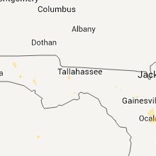
Mississippi
| Local Time | Report Details |
|---|---|
| 1:25 PM CDT | Reports that a tree fell on a house in boyle and a tree was down in clevelan in bolivar county MS, 93.5 miles NE of Bastrop, LA |
| 1:30 PM CDT | Power and traffic lights out in city due to down tree limbs on power line in coahoma county MS, 72.1 miles SSW of Memphis, TN |
| 1:32 PM CDT | Power and traffic lights out in city due to down tree limbs on power line in coahoma county MS, 72.1 miles SSW of Memphis, TN |
| 1:52 PM CDT | Reports of light poles blown down. also reports of pea size hail and a tree struck by lightning in nearby morehead at ms delta community colleg in sunflower county MS, 76.3 miles NNW of Jackson, MS |
| 2:05 PM CDT | Quarter sized hail reported near Moorhead, MS, 81.6 miles NNW of Jackson, MS |
| 4:11 PM CDT | Roofs blown off of a few sheds in winston county MS, 38.5 miles SSW of Starkville, MS |
| 4:29 PM CDT | Trees and powerlines down...reported by peterson country store in winston county MS, 18.5 miles SSW of Starkville, MS |
| 4:35 PM CDT | Reports of trees down on north columbus a in winston county MS, 22.5 miles SSW of Starkville, MS |
| 4:45 PM CDT | Powerlines down in kemper county MS, 47.9 miles SSE of Starkville, MS |
| 5:30 PM CDT | Tree limbs down in newto in newton county MS, 59.7 miles E of Jackson, MS |
| 5:30 PM CDT | Trees down on n washington st and on east av in warren county MS, 40.4 miles W of Jackson, MS |
| 5:30 PM CDT | Trees down on n washington st and on east av in warren county MS, 40.6 miles W of Jackson, MS |
| 5:33 PM CDT | A few trees down on church road due to outflow...reported by wtok-tv in newton county MS, 59.7 miles E of Jackson, MS |
| 5:40 PM CDT | Reports of a tree down on logue circl in warren county MS, 38.8 miles W of Jackson, MS |
| 6:10 PM CDT | Trees down in crystal springs and hazlehurst on rhym in copiah county MS, 34.3 miles SSW of Jackson, MS |
| 6:15 PM CDT | Trees down around lake lincol in lincoln county MS, 43.4 miles SSW of Jackson, MS |
| 7:00 PM CDT | 10 to 15 trees down county wide in jasper c in jasper county MS, 57.2 miles ESE of Jackson, MS |
| 7:15 PM CDT | Trees down on powerlines in l in jones county MS, 74.1 miles SE of Jackson, MS |
Alabama
| Local Time | Report Details |
|---|---|
| 3:00 PM CDT | Quarter sized hail reported near Mobile, AL, 9.6 miles SW of Mobile, AL, quarter size hail reported in tillmans corner. |
| 3:15 PM CDT | Half Dollar sized hail reported near Mobile, AL, 18.1 miles WSW of Mobile, AL, nws employee reported nickel to larger than quarter size hail at residence 8 sw of downtown mobile. |
| 3:18 PM CDT | High winds from a thunderstorm downed down a fence...blew patio furnature across the yard and ripped off sidin in baldwin county AL, 29.7 miles ESE of Mobile, AL |
| 3:20 PM CDT | Half Dollar sized hail reported near Mobile, AL, 5.6 miles SW of Mobile, AL, half dollar size hail reported on lakeside drive in mobile. |
| 5:07 PM CDT | Quarter sized hail reported near Frisco City, AL, 39.3 miles S of Camden, AL, monroe county em reported quarter size hail in frisco city. |
| 5:30 PM CDT | Several trees down in the community of boy in sumter county AL, 65.2 miles SSE of Starkville, MS |
Florida
| Local Time | Report Details |
|---|---|
| 4:25 PM EDT | Numerous trees and powerlines were reported down along a 1 to 2 mile stretch of county road 314a from the 3700 to 6000 bloc in marion county FL, 56.2 miles NNW of Orlando, FL |
| 4:29 PM EDT | Large tree fell on a house on northeast 166th terrace. no injuries were reported. residents were not home at the time. numerous trees and powerlines were reported down in marion county FL, 57.7 miles NNW of Orlando, FL |
| 4:29 PM EDT | Numerous tree damage reported with tops of large oak trees torn off from strong downburst winds. power outages reported in the area. pea sized hail also reporte in marion county FL, 57.7 miles NNW of Orlando, FL |
| 5:21 PM EDT | Trees down on powerlines on old kings road in bulo in flagler county FL, 62.3 miles NNE of Orlando, FL |
| 4:31 PM CDT | Quarter sized hail reported near Freeport, FL, 16.4 miles ENE of Miramar Beach, FL, 1 inch hail near old jolly bay rd. and 331. also a funnel cloud was reported and lightning struck a sheriff substation causing fires in the area. |
| 5:31 PM EDT | Trees down on powerlines on old kings road in bulo in flagler county FL, 62.3 miles NNE of Orlando, FL |
Kansas
| Local Time | Report Details |
|---|---|
| 3:45 PM CDT | Half Dollar sized hail reported near Russell, KS, 26 miles E of Hays, KS |
| 4:00 PM CDT | Hen Egg sized hail reported near Hays, KS, 9.8 miles SSE of Hays, KS |
| 4:10 PM CDT | Ping Pong Ball sized hail reported near Mankato, KS, 75.7 miles NE of Hays, KS, hail covered one half to three quarters of the ground. |
| 4:13 PM CDT | Golf Ball sized hail reported near Russell, KS, 29.8 miles E of Hays, KS |
| 4:14 PM CDT | Quarter sized hail reported near Russell, KS, 24.6 miles ESE of Hays, KS |
| 4:17 PM CDT | Hen Egg sized hail reported near Sylvan Grove, KS, 51 miles E of Hays, KS |
| 4:18 PM CDT | Hen Egg sized hail reported near Hays, KS, 2.5 miles SW of Hays, KS |
| 4:20 PM CDT | Baseball sized hail reported near Hays, KS, 0.9 miles NE of Hays, KS |
| 4:25 PM CDT | Quarter sized hail reported near Mankato, KS, 78 miles NE of Hays, KS |
| 4:28 PM CDT | Golf Ball sized hail reported near Hays, KS, 0.8 miles NNW of Hays, KS |
| 4:29 PM CDT | 50 to 60 mph winds on the north side of beloi in mitchell county KS, 77.6 miles ENE of Hays, KS |
| 4:30 PM CDT | Quarter sized hail reported near Levant, KS, 13.5 miles NW of Colby, KS |
| 4:36 PM CDT | Quarter sized hail reported near Brewster, KS, 18 miles W of Colby, KS |
| 4:37 PM CDT | Quarter sized hail reported near Ness City, KS, 34.8 miles SSW of Hays, KS |
| 4:39 PM CDT | Golf Ball sized hail reported near Victoria, KS, 15.9 miles SE of Hays, KS |
| 4:40 PM CDT | Golf Ball sized hail reported near Brewster, KS, 18.1 miles W of Colby, KS, mostly quarter sized hail with a few larger stones. |
| 4:42 PM CDT | Tennis Ball sized hail reported near Victoria, KS, 15.1 miles ESE of Hays, KS |
| 4:43 PM CDT | Quarter sized hail reported near Cheney, KS, 22.2 miles W of Wichita, KS |
| 4:44 PM CDT | Quarter sized hail reported near Russell, KS, 31.9 miles ESE of Hays, KS |
| 4:44 PM CDT | Golf Ball sized hail reported near Victoria, KS, 15.1 miles ESE of Hays, KS |
| 4:44 PM CDT | Quarter sized hail reported near Atwood, KS, 23.5 miles NNE of Colby, KS |
| 4:50 PM CDT | Storm damage reported in cloud county KS, 71.2 miles WNW of Manhattan, KS |
| 4:50 PM CDT | Ping Pong Ball sized hail reported near Hoisington, KS, 31.4 miles ESE of Hays, KS |
| 4:53 PM CDT | Quarter sized hail reported near Concordia, KS, 71.2 miles WNW of Manhattan, KS |
| 4:56 PM CDT | Golf Ball sized hail reported near Gorham, KS, 16.8 miles E of Hays, KS |
| 4:59 PM CDT | Quarter sized hail reported near Ness City, KS, 50.1 miles ENE of Garden City, KS |
| 5:00 PM CDT | Quarter sized hail reported near Alexander, KS, 31.9 miles SSW of Hays, KS |
| 5:07 PM CDT | Half Dollar sized hail reported near Wichita, KS, 9 miles W of Wichita, KS, at 135th and central. |
| 5:09 PM CDT | Quarter sized hail reported near Wichita, KS, 9 miles W of Wichita, KS |
| 5:10 PM CDT | Quarter sized hail reported near Wichita, KS, 7.9 miles W of Wichita, KS, 119th and maple st |
| 5:11 PM CDT | Golf Ball sized hail reported near Wichita, KS, 8.1 miles WNW of Wichita, KS, mostly penny to nickle with some golf ball size |
| 5:12 PM CDT | Ping Pong Ball sized hail reported near Victoria, KS, 13.4 miles ESE of Hays, KS |
| 5:12 PM CDT | Golf Ball sized hail reported near Alexander, KS, 30.7 miles SSW of Hays, KS |
| 5:18 PM CDT | Wind estimated 60 to 70 mph. significant crop damage from wind and hail but no estimated hail size. time estimate in ottawa county KS, 72.4 miles W of Manhattan, KS |
| 5:19 PM CDT | Golf Ball sized hail reported near Wichita, KS, 7.4 miles W of Wichita, KS, central and tyler roads. |
| 5:19 PM CDT | Golf Ball sized hail reported near Wichita, KS, 3 miles W of Wichita, KS |
| 5:19 PM CDT | Hen Egg sized hail reported near Wichita, KS, 2.4 miles W of Wichita, KS, spotter reported 1 west of cow town |
| 5:20 PM CDT | Golf Ball sized hail reported near Colby, KS, 19.3 miles SW of Colby, KS |
| 5:21 PM CDT | Hen Egg sized hail reported near Wichita, KS, 5.7 miles W of Wichita, KS, at maple and west street. |
| 5:22 PM CDT | Quarter sized hail reported near Wichita, KS, 0.3 miles NW of Wichita, KS, 800 main street downtown. |
| 5:23 PM CDT | Quarter sized hail reported near Wichita, KS, 7.9 miles WNW of Wichita, KS |
| 5:23 PM CDT | Quarter sized hail reported near Ellsworth, KS, 65.5 miles E of Hays, KS |
| 5:24 PM CDT | Tennis Ball sized hail reported near Alexander, KS, 29.6 miles SSW of Hays, KS |
| 5:24 PM CDT | Hen Egg sized hail reported near Alexander, KS, 30.1 miles SSW of Hays, KS |
| 5:25 PM CDT | Half Dollar sized hail reported near Monument, KS, 20.5 miles S of Colby, KS |
| 5:28 PM CDT | Ping Pong Ball sized hail reported near Wichita, KS, 3.9 miles WNW of Wichita, KS, near 235 and zoo blvd |
| 5:30 PM CDT | Quarter sized hail reported near Wichita, KS, 7.2 miles WNW of Wichita, KS, off duty nws employee. near 21st and maize. |
| 5:33 PM CDT | Half Dollar sized hail reported near Wichita, KS, 5.7 miles W of Wichita, KS, at 13th and west. |
| 5:35 PM CDT | Quarter sized hail reported near Wichita, KS, 0.3 miles NW of Wichita, KS, 1 inch hail at the eoc downtown |
| 5:35 PM CDT | Golf Ball sized hail reported near Wichita, KS, 6.2 miles ESE of Wichita, KS, spotter reported minor damage to vehicles and small plants. the hail lasted for about 2 minutes. |
| 5:36 PM CDT | Golf Ball sized hail reported near Wichita, KS, 4.2 miles E of Wichita, KS, off duty nws employee. hillside and douglas. |
| 5:36 PM CDT | Ping Pong Ball sized hail reported near Wichita, KS, 2.6 miles NNW of Wichita, KS |
| 5:39 PM CDT | Hen Egg sized hail reported near McPherson, KS, 50.3 miles NNW of Wichita, KS |
| 5:40 PM CDT | Quarter sized hail reported near Whitewater, KS, 20.9 miles NNE of Wichita, KS, off duty nws employee. |
| 5:41 PM CDT | Ping Pong Ball sized hail reported near McPherson, KS, 50.3 miles NNW of Wichita, KS |
| 5:46 PM CDT | Golf Ball sized hail reported near Hays, KS, 11.1 miles S of Hays, KS |
| 5:50 PM CDT | Quarter sized hail reported near Wichita, KS, 7.4 miles E of Wichita, KS, at greenwich and kellogg. |
| 5:50 PM CDT | Quarter sized hail reported near Wichita, KS, 2.3 miles ESE of Wichita, KS, spotter was near lincoln and hillside |
| 5:50 PM CDT | Golf Ball sized hail reported near Hoisington, KS, 21.8 miles SE of Hays, KS, mainly pea size but a few were golfball size. |
| 5:50 PM CDT | Quarter sized hail reported near Marquette, KS, 60.7 miles NNW of Wichita, KS |
| 5:53 PM CDT | Half Dollar sized hail reported near Wichita, KS, 2 miles E of Wichita, KS, douglas and hillside |
| 5:55 PM CDT | Golf Ball sized hail reported near Hays, KS, 9.8 miles SSE of Hays, KS |
| 5:57 PM CDT | Golf Ball sized hail reported near Ness City, KS, 52.2 miles ENE of Garden City, KS |
| 5:57 PM CDT | Half Dollar sized hail reported near McConnell Air Force Base, KS, 5.9 miles SE of Wichita, KS, delayed report. |
| 6:00 PM CDT | Hen Egg sized hail reported near Wichita, KS, 2 miles E of Wichita, KS, near douglas and hillside spotter reported 1 1/2 to 2 inches. |
| 6:01 PM CDT | Half Dollar sized hail reported near Wichita, KS, 2 miles ESE of Wichita, KS, spotter reported near hillside and east kellogg. |
| 6:03 PM CDT | Hen Egg sized hail reported near Ness City, KS, 52.2 miles SW of Hays, KS |
| 6:05 PM CDT | Storm damage reported in riley county KS, 24.1 miles NNW of Manhattan, KS |
| 6:07 PM CDT | Half Dollar sized hail reported near Wichita, KS, 6.4 miles E of Wichita, KS, quarter to half dollar sized hail. minor damage to cars. |
| 6:10 PM CDT | Half Dollar sized hail reported near Wichita, KS, 4.7 miles E of Wichita, KS, near central and rock road. |
| 6:10 PM CDT | Golf Ball sized hail reported near Andover, KS, 11 miles ESE of Wichita, KS, spotter reported golf ball size hail 3 miles south of andover on butler road. |
| 6:14 PM CDT | Golf Ball sized hail reported near Hutchinson, KS, 41.5 miles NW of Wichita, KS |
| 6:15 PM CDT | Half Dollar sized hail reported near Scott City, KS, 42.7 miles NNW of Garden City, KS |
| 6:15 PM CDT | Storm damage reported in pottawatomie county KS, 17.7 miles NNW of Manhattan, KS |
| 6:16 PM CDT | Slide was blown off wooden playset and trampoline was wrapped around the neighbors fence. tree damage also reported in the area in sedgwick county KS, 8.3 miles ENE of Wichita, KS |
| 6:17 PM CDT | Golf Ball sized hail reported near Wichita, KS, 6.3 miles ESE of Wichita, KS |
| 6:17 PM CDT | Ping Pong Ball sized hail reported near Andover, KS, 10.7 miles E of Wichita, KS, andover road and kellog |
| 6:20 PM CDT | Quarter sized hail reported near Andover, KS, 10.7 miles E of Wichita, KS |
| 6:21 PM CDT | Storm damage reported in pottawatomie county KS, 18.6 miles NNW of Manhattan, KS |
| 6:27 PM CDT | Golf Ball sized hail reported near Scott City, KS, 47.7 miles N of Garden City, KS |
| 6:29 PM CDT | Storm damage reported in pottawatomie county KS, 10 miles NNE of Manhattan, KS |
| 6:32 PM CDT | Storm damage reported in barton county KS, 41.9 miles SE of Hays, KS |
| 6:33 PM CDT | Storm damage reported in pottawatomie county KS, 14.1 miles NNE of Manhattan, KS |
| 6:34 PM CDT | Storm damage reported in pottawatomie county KS, 16.1 miles NE of Manhattan, KS |
| 6:36 PM CDT | Quarter sized hail reported near Inman, KS, 43.2 miles NW of Wichita, KS, the ground was covered with hail. |
| 6:38 PM CDT | Quarter sized hail reported near Jetmore, KS, 54.5 miles ENE of Garden City, KS |
| 6:39 PM CDT | Half Dollar sized hail reported near Augusta, KS, 18.9 miles E of Wichita, KS, on highway 54. |
| 6:41 PM CDT | Tennis Ball sized hail reported near Alexander, KS, 30.7 miles SSW of Hays, KS |
| 6:43 PM CDT | Golf Ball sized hail reported near Augusta, KS, 19.5 miles E of Wichita, KS |
| 6:44 PM CDT | Small cottonwood limbs up to an inch in diameter dow in pottawatomie county KS, 9.9 miles E of Manhattan, KS |
| 6:45 PM CDT | Half Dollar sized hail reported near Augusta, KS, 19.5 miles E of Wichita, KS, at the emergency operations center. |
| 6:47 PM CDT | Quarter sized hail reported near Jetmore, KS, 54.3 miles ENE of Garden City, KS |
| 6:50 PM CDT | Quarter sized hail reported near Alexander, KS, 32.9 miles SSW of Hays, KS |
| 6:52 PM CDT | Major tree damage throughout city with numerous power poles downed. power out across cit in mcpherson county KS, 36.8 miles NNW of Wichita, KS |
| 6:53 PM CDT | Inch and a half in diameter tree limbs down in pottawatomie county KS, 13.8 miles ENE of Manhattan, KS |
| 6:55 PM CDT | 6 to 7 inch tree limbs downed in the city in pottawatomie county KS, 13.6 miles E of Manhattan, KS |
| 6:59 PM CDT | Trained spotter reported 50 to 60 mph winds in nickerso in reno county KS, 52.1 miles NW of Wichita, KS |
| 6:59 PM CDT | Quarter sized hail reported near Leon, KS, 26.2 miles E of Wichita, KS |
| 7:02 PM CDT | On the north side of tow in reno county KS, 41.9 miles NW of Wichita, KS |
| 7:03 PM CDT | Storm damage reported in reno county KS, 39.2 miles NW of Wichita, KS |
| 7:03 PM CDT | Near 23rd and main street at fire station number in reno county KS, 42.3 miles NW of Wichita, KS |
| 7:03 PM CDT | Power lines and power poles down. winds estimated at 60 mp in reno county KS, 41 miles NW of Wichita, KS |
| 7:06 PM CDT | Quarter sized hail reported near Leon, KS, 30.5 miles E of Wichita, KS, 1 mile north of leon on bluestem road. |
| 7:07 PM CDT | Storm damage reported in reno county KS, 42.8 miles NW of Wichita, KS |
| 7:07 PM CDT | There are reports of power poles and power lines down with power outages in a large portion of hutchinso in reno county KS, 41 miles NW of Wichita, KS |
| 7:10 PM CDT | Trained spotter reports 7 trees snapped at the base or uprooted with the largest tree being 2 feet at the base. lots of damage at a trailer park and limbs down in many in sedgwick county KS, 7.8 miles N of Wichita, KS |
| 7:24 PM CDT | Storm damage reported in hodgeman county KS, 53 miles SW of Hays, KS |
| 7:24 PM CDT | Quarter sized hail reported near Jetmore, KS, 53 miles SW of Hays, KS |
| 7:25 PM CDT | Quarter sized hail reported near Leon, KS, 30.5 miles E of Wichita, KS |
| 7:25 PM CDT | Golf Ball sized hail reported near Nekoma, KS, 33.7 miles S of Hays, KS |
| 7:27 PM CDT | 3 inch limbs dow in harvey county KS, 31.7 miles N of Wichita, KS |
| 7:28 PM CDT | Numerous limbs down across town in addition to a few trees in harvey county KS, 24.3 miles N of Wichita, KS |
| 7:28 PM CDT | Small branches dow in harvey county KS, 24.4 miles N of Wichita, KS |
| 7:28 PM CDT | Quarter sized hail reported near Newton, KS, 23.7 miles N of Wichita, KS |
| 7:30 PM CDT | Golf Ball sized hail reported near Deerfield, KS, 23 miles WNW of Garden City, KS |
| 7:35 PM CDT | Widespread tree and powerline damage was reported in hanston along with a few damaged out buildings in and around town. there were also numerous downed power poles espe in hodgeman county KS, 55.7 miles SSW of Hays, KS |
| 7:35 PM CDT | Power lines and trees were downed and roofs were damage in hodgeman county KS, 54.2 miles E of Garden City, KS |
| 7:37 PM CDT | Quarter sized hail reported near Hanston, KS, 53.9 miles SSW of Hays, KS |
| 7:38 PM CDT | Golf Ball sized hail reported near Mt Hope, KS, 21.8 miles NW of Wichita, KS, also reporting 60 mph winds. |
| 7:38 PM CDT | Also reported golfball sized hai in sedgwick county KS, 21.8 miles NW of Wichita, KS |
| 7:40 PM CDT | Power outage in the city of chene in sedgwick county KS, 24.7 miles W of Wichita, KS |
| 7:44 PM CDT | Numerous tree limbs down in sedgwick in harvey county KS, 16.9 miles NNW of Wichita, KS |
| 7:45 PM CDT | Gusts estimated up to 60 mph in shawnee county KS, 34 miles E of Manhattan, KS |
| 7:50 PM CDT | Off duty nws employee reporte in sedgwick county KS, 8.2 miles WNW of Wichita, KS |
| 7:51 PM CDT | Storm damage reported in butler county KS, 27.4 miles NNE of Wichita, KS |
| 7:52 PM CDT | Storm damage reported in sedgwick county KS, 10.7 miles N of Wichita, KS |
| 7:52 PM CDT | A framed building under construction was blown completely to the ground. time estimated based on reports and rada in shawnee county KS, 39.6 miles E of Manhattan, KS |
| 7:55 PM CDT | Quarter sized hail reported near Benton, KS, 14.3 miles ENE of Wichita, KS |
| 7:56 PM CDT | Storm damage reported in sedgwick county KS, 6.7 miles NNW of Wichita, KS |
| 7:58 PM CDT | Storm damage reported in sedgwick county KS, 9.1 miles W of Wichita, KS |
| 7:59 PM CDT | Winds were estimated at 60 to 70 mp in edwards county KS, 63.6 miles S of Hays, KS |
| 8:00 PM CDT | Storm damage reported in ford county KS, 69.8 miles E of Garden City, KS |
| 8:00 PM CDT | Storm damage reported in ford county KS, 67.4 miles E of Garden City, KS |
| 8:00 PM CDT | Quarter sized hail reported near Dodge City, KS, 45.3 miles E of Garden City, KS |
| 8:01 PM CDT | Carport blown into a tree near central and andover roa in butler county KS, 10.7 miles E of Wichita, KS |
| 8:03 PM CDT | Off duty national weather service employee reported winds of 60 to 70 mp in sedgwick county KS, 7.7 miles WNW of Wichita, KS |
| 8:06 PM CDT | Storm damage reported in sedgwick county KS, 5.9 miles SE of Wichita, KS |
| 8:06 PM CDT | Relayed by wibw studios in shawnee county KS, 48.2 miles E of Manhattan, KS |
| 8:08 PM CDT | Near wibw studios off of wanamaker roa in shawnee county KS, 48.2 miles E of Manhattan, KS |
| 8:08 PM CDT | Near 45th and k1 in sedgwick county KS, 6.5 miles SSE of Wichita, KS |
| 8:08 PM CDT | Power outages reported from north topeka west into wi in shawnee county KS, 44.5 miles ESE of Manhattan, KS |
| 8:12 PM CDT | Storm damage reported in sedgwick county KS, 7.7 miles NE of Wichita, KS |
| 8:13 PM CDT | Storm damage reported in sedgwick county KS, 5.9 miles SE of Wichita, KS |
| 8:13 PM CDT | Storm damage reported in sedgwick county KS, 15.2 miles SW of Wichita, KS |
| 8:13 PM CDT | Storm damage reported in ford county KS, 70.8 miles ESE of Garden City, KS |
| 8:14 PM CDT | Andover fire department reports winds of 60 to 70 mp in butler county KS, 10.7 miles E of Wichita, KS |
| 8:14 PM CDT | Storm damage reported in butler county KS, 13.5 miles ESE of Wichita, KS |
| 8:18 PM CDT | Storm damage reported in butler county KS, 15.8 miles NE of Wichita, KS |
| 8:24 PM CDT | Quarter sized hail reported near Ensign, KS, 40 miles SE of Garden City, KS |
| 8:30 PM CDT | 8 inch diameter tree limbs down and a large sign blown down in rose hil in butler county KS, 13.9 miles SE of Wichita, KS |
| 8:30 PM CDT | There were five power poles down and winds estimated at 70 mp in pratt county KS, 82 miles W of Wichita, KS |
| 8:33 PM CDT | Storm damage reported in sumner county KS, 22.4 miles SSE of Wichita, KS |
| 8:35 PM CDT | Measured 63 mph winds on highway 7 in butler county KS, 20.2 miles ESE of Wichita, KS |
| 8:39 PM CDT | Fire department reports 1.5 miles of power poles snapped off along 55th street south between maize and tyle in sedgwick county KS, 9.2 miles SW of Wichita, KS |
| 8:50 PM CDT | Storm damage reported in butler county KS, 31.6 miles E of Wichita, KS |
| 8:51 PM CDT | Storm damage reported in comanche county KS, 57.8 miles N of Woodward, OK |
| 9:01 PM CDT | Quarter sized hail reported near Englewood, KS, 61.6 miles NW of Woodward, OK |
| 9:11 PM CDT | Storm damage reported in barber county KS, 75 miles WSW of Wichita, KS |
| 9:13 PM CDT | Quarter sized hail reported near Harper, KS, 49.4 miles WSW of Wichita, KS, law enforcement reported quarter size hail at north west 40th avenue and north west 150th road. |
| 9:35 PM CDT | Three inch diameter tree limbs blown down. wind driven hail broke out a window on a pickup topper. hail size unknow in barber county KS, 54.6 miles NE of Woodward, OK |
Louisiana
| Local Time | Report Details |
|---|---|
| 4:35 PM CDT | Reports of a few powerlines down on highway 128 near fort necessit in franklin county LA, 51.8 miles S of Bastrop, LA |
Connect with Interactive Hail Maps