

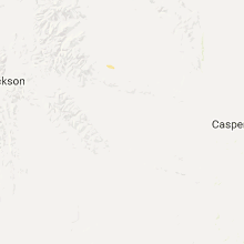
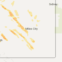
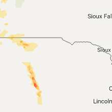
Hail Map for Wednesday, July 27, 2016

Number of Impacted Households on 7/27/2016
0
Impacted by 1" or Larger Hail
0
Impacted by 1.75" or Larger Hail
0
Impacted by 2.5" or Larger Hail
Square Miles of Populated Area Impacted on 7/27/2016
0
Impacted by 1" or Larger Hail
0
Impacted by 1.75" or Larger Hail
0
Impacted by 2.5" or Larger Hail


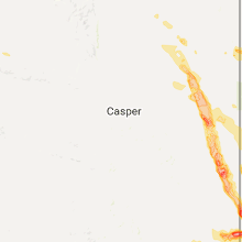


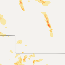


Cities Most Affected by Hail Storms of 7/27/2016
| Hail Size | Demographics of Zip Codes Affected | ||||||
|---|---|---|---|---|---|---|---|
| City | Count | Average | Largest | Pop Density | House Value | Income | Age |
| Pompeys Pillar, MT | 4 | 2.25 | 2.75 | 1 | $69k | $34.6k | 41.5 |
| Howard Lake, MN | 2 | 2.75 | 3.00 | 40 | $113k | $45.9k | 39.3 |
| Eaton, CO | 2 | 1.88 | 2.00 | 71 | $146k | $43.6k | 38.4 |
| Whitman, NE | 2 | 1.88 | 2.00 | 0 | $22k | $33.4k | 35.5 |
| Yoder, WY | 2 | 1.75 | 1.75 | 1 | $66k | $30.4k | 49.6 |
| Billings, MT | 2 | 1.75 | 1.75 | 289 | $113k | $42.7k | 36.1 |
| Nunn, CO | 2 | 1.75 | 1.75 | 4 | $104k | $41.1k | 41.3 |
| Pine Bluffs, WY | 2 | 1.75 | 1.75 | 2 | $82k | $33.5k | 44.0 |
| Kersey, CO | 1 | 2.50 | 2.50 | 14 | $132k | $47.9k | 36.9 |
| Forsyth, MT | 1 | 2.50 | 2.50 | 0 | $62k | $35.3k | 46.7 |
| Manville, WY | 1 | 2.50 | 2.50 | 0 | $48k | $20.9k | 55.1 |
| Broken Bow, NE | 1 | 2.00 | 2.00 | 12 | $57k | $31.8k | 42.8 |
| Jordan, MT | 1 | 2.00 | 2.00 | 0 | $36k | $25.3k | 47.4 |
| Rexford, KS | 1 | 2.00 | 2.00 | 1 | $30k | $39.4k | 38.5 |
| Atwood, KS | 1 | 2.00 | 2.00 | 4 | $49k | $32.6k | 50.7 |
| Kimball, NE | 1 | 2.00 | 2.00 | 7 | $54k | $30.6k | 45.6 |
| Arriba, CO | 1 | 1.75 | 1.75 | 1 | $56k | $26.9k | 49.1 |
| Mitchell, NE | 1 | 1.75 | 1.75 | 12 | $70k | $33.1k | 43.4 |
| Mullen, NE | 1 | 1.75 | 1.75 | 0 | $41k | $28.7k | 49.6 |
| Mason City, NE | 1 | 1.75 | 1.75 | 2 | $26k | $29.9k | 46.0 |
| Volborg, MT | 1 | 1.75 | 1.75 | 0 | $106k | $36.3k | 48.7 |
| Minatare, NE | 1 | 1.75 | 1.75 | 9 | $46k | $31.0k | 41.7 |
| Lingle, WY | 1 | 1.75 | 1.75 | 3 | $78k | $36.6k | 46.5 |
| Leoti, KS | 1 | 1.75 | 1.75 | 2 | $56k | $33.3k | 39.7 |
| Morrill, NE | 1 | 1.75 | 1.75 | 8 | $55k | $31.2k | 42.7 |
| Saint Francis, KS | 1 | 1.75 | 1.75 | 2 | $50k | $31.4k | 51.1 |
| Bushnell, NE | 1 | 1.75 | 1.75 | 0 | $20k | $28.1k | 53.3 |
| Sand Springs, MT | 1 | 1.75 | 1.75 | 0 | $258k | $26.3k | 44.8 |
Hail and Wind Damage Spotted on 7/27/2016
Filter by Report Type:Hail ReportsWind Reports
States Impacted
Wisconsin, Kansas, Minnesota, Michigan, Virginia, Montana, Tennessee, South Dakota, Kentucky, Nebraska, North Carolina, Colorado, Wyoming, Arizona, Illinois, Oklahoma, Arkansas, Maine, Texas, West VirginiaWisconsin
| Local Time | Report Details |
|---|---|
| 10:32 AM CDT | Lots of trees and power lines down. tree on a garage. time estimated by rada in waupaca county WI, 57.3 miles W of Green Bay, WI |
| 10:42 AM CDT | Trees down at intersection of hwy 161 and netzler road. time estimated by rada in waupaca county WI, 52.4 miles W of Green Bay, WI |
| 10:52 AM CDT | Trees down. time estimated by rada in waupaca county WI, 50.6 miles W of Green Bay, WI |
| 3:09 PM CDT | Quarter sized hail reported near Hudson, WI, 26.9 miles E of Minneapolis, MN, . |
| 5:10 PM CDT | Stop sign snapped at hwy 29 and hwy 97. courtesy of wsaw-tv social medi in marathon county WI, 57.6 miles SW of Rhinelander, WI |
| 7:50 PM CDT | Some trees down. delayed report. time estimate in shawano county WI, 50.1 miles SSE of Rhinelander, WI |
Kansas
| Local Time | Report Details |
|---|---|
| 11:05 AM MDT | Time estimated. dispatch received report of a carport tossed from a backyard and poking a hole in roof of neighbo in wallace county KS, 51.6 miles SW of Colby, KS |
| 3:15 PM CDT | Golf Ball sized hail reported near Leoti, KS, 36.2 miles NW of Garden City, KS, hail covering ground... torrential rainfall with water running down the road. had been occuring for 10 min before the report. |
| 6:00 PM CDT | Ping Pong Ball sized hail reported near Scott City, KS, 48.7 miles N of Garden City, KS, hail was mostly grape size or smaller. |
| 6:00 PM CDT | Visibility down to a 100 yards in blowing dust for a short tim in grant county KS, 34.7 miles SSW of Garden City, KS |
| 6:25 PM CDT | Tree limbs up to 3 inches in diameter were blown dow in stevens county KS, 50.1 miles SSW of Garden City, KS |
| 6:49 PM CDT | Winds estimated at 60-70 mp in seward county KS, 55.2 miles S of Garden City, KS |
| 6:51 PM CDT | Half Dollar sized hail reported near Liberal, KS, 56.4 miles SSW of Garden City, KS, . |
| 11:14 PM CDT | Golf Ball sized hail reported near Saint Francis, KS, 37.5 miles WNW of Colby, KS |
| 10:20 PM MDT | Ping Pong Ball sized hail reported near Goodland, KS, 35.8 miles W of Colby, KS |
| 10:22 PM MDT | Quarter sized hail reported near Goodland, KS, 35.8 miles W of Colby, KS |
| 11:50 PM CDT | Hen Egg sized hail reported near Atwood, KS, 27.8 miles N of Colby, KS |
| 11:56 PM CDT | Quarter sized hail reported near Atwood, KS, 23.7 miles N of Colby, KS |
| 11:05 PM MDT | Time estimated. dispatch received report of a carport tossed from a backyard and poking a hole in roof of neighbo in wallace county KS, 51.6 miles SW of Colby, KS |
| 12:20 AM CDT | Hen Egg sized hail reported near Rexford, KS, 17.1 miles ENE of Colby, KS, social media report. |
| 11:24 PM MDT | Estimated winds of 50 to 60 mp in wallace county KS, 58.6 miles SW of Colby, KS |
| 2:30 AM CDT | Kdot mesonet station 1 ene garden city /ks010 in finney county KS, 1.9 miles ENE of Garden City, KS |
| 3:19 AM MDT | Storm damage reported in sherman county KS, 27.8 miles WNW of Colby, KS |
Minnesota
| Local Time | Report Details |
|---|---|
| 12:09 PM CDT | Large 15 to 20 inch tree branch dow in mcleod county MN, 37.5 miles W of Minneapolis, MN |
| 12:10 PM CDT | Quarter sized hail reported near Winsted, MN, 38.5 miles W of Minneapolis, MN, extremely heavy rain reported too. |
| 12:12 PM CDT | Tennis Ball sized hail reported near Howard Lake, MN, 37.5 miles W of Minneapolis, MN, social media image with ruler. |
| 12:12 PM CDT | Tea Cup sized hail reported near Howard Lake, MN, 37.5 miles W of Minneapolis, MN, social media image with ruler. |
| 12:16 PM CDT | Tree down on power line on fir in mcleod county MN, 37.5 miles W of Minneapolis, MN |
| 12:42 PM CDT | Metal roofing ripped off barn and thrown 50 yards. multiple trees down on power line in wright county MN, 25.8 miles W of Minneapolis, MN |
| 12:57 PM CDT | Tree down on power line on fir in mcleod county MN, 37.5 miles W of Minneapolis, MN |
| 2:05 PM CDT | Trees down. time estimate in chisago county MN, 39.2 miles NNE of Minneapolis, MN |
| 2:18 PM CDT | 61 mph gust measured at st paul airport. in ramsey county MN, 10.6 miles ESE of Minneapolis, MN |
Michigan
| Local Time | Report Details |
|---|---|
| 1:25 PM EDT | Tree down. time estimated by rada in lake county MI, 46.1 miles SSW of Traverse City, MI |
| 2:29 PM EDT | Reports of power lines down in several locations. time estimated by rada in wexford county MI, 32.7 miles SSE of Traverse City, MI |
| 2:30 PM EDT | At least a few reports of trees or powerlines down in the county... including along us-10 and also around tusti in osceola county MI, 62 miles SSE of Traverse City, MI |
| 2:30 PM EDT | 2 trees down over the road in the area of clarence rd and bringold av in clare county MI, 60.8 miles SSE of Traverse City, MI |
| 2:45 PM EDT | Reports of several trees down and resulting damage to homes. time estimated by rada in gladwin county MI, 77.5 miles SE of Traverse City, MI |
Virginia
| Local Time | Report Details |
|---|---|
| 2:05 PM EDT | One tree down on malus drive in roanoke county VA, 11 miles W of Roanoke, VA |
| 2:06 PM EDT | Tree down on a structure off route 340 in crimor in augusta county VA, 76.2 miles SE of Elkins, WV |
| 2:07 PM EDT | Roof ripped off a building on industrial driv in city of salem county VA, 6.7 miles W of Roanoke, VA |
| 2:07 PM EDT | Several trees down on west riverside drive near kingsmill driv in city of salem county VA, 8.3 miles W of Roanoke, VA |
| 2:08 PM EDT | Trees down on power lines near crimor in augusta county VA, 76.7 miles SE of Elkins, WV |
| 2:10 PM EDT | Several trees down on west riverside drive near kingsmill driv in city of salem county VA, 8.3 miles W of Roanoke, VA |
| 2:21 PM EDT | Roof ripped off a building on industrial driv in city of salem county VA, 6.7 miles W of Roanoke, VA |
| 2:44 PM EDT | One tree down at the intersection of back creek road and mayo drive in roanoke county VA, 6.3 miles S of Roanoke, VA |
| 3:15 PM EDT | One tree down on northridge road near the intersection with hardy road in franklin county VA, 13 miles SE of Roanoke, VA |
| 3:15 PM EDT | Five trees down on middle valley road in franklin county VA, 14.3 miles SE of Roanoke, VA |
| 3:23 PM EDT | One tree down on cahas mountain road in franklin county VA, 13.5 miles SSW of Roanoke, VA |
| 3:50 PM EDT | One foot diameter tree down on lakestone road in franklin county VA, 22.5 miles SE of Roanoke, VA |
| 4:21 PM EDT | One tree down on a storage building along highfield circle in franklin county VA, 19.4 miles S of Roanoke, VA |
| 4:27 PM EDT | One tree down near the intersection of franklin street and pleasant hill road in franklin county VA, 22.2 miles S of Roanoke, VA |
| 4:27 PM EDT | One tree down on a vehicle on ferrum mountain road near the intersection with franklin street in franklin county VA, 24.6 miles S of Roanoke, VA |
| 4:27 PM EDT | Multiple trees down throughout the town in pittsylvania county VA, 38.5 miles SE of Roanoke, VA |
| 4:34 PM EDT | Thunderstorm winds resulted in at least two trees down along commonwealth road in carroll county... va. the road was temporarily close in carroll county VA, 63.9 miles SW of Roanoke, VA |
| 4:44 PM EDT | Multiple trees down throughout the town in pittsylvania county VA, 43.8 miles ESE of Roanoke, VA |
| 5:00 PM EDT | Tree down on murry hill road in henry county VA, 35.3 miles S of Roanoke, VA |
| 5:03 PM EDT | Tree down on sontag road near toms knob road in franklin county VA, 27.6 miles SSE of Roanoke, VA |
| 5:08 PM EDT | Thunderstorm winds downed numerous trees within the community of horse pasture closing several roadway in henry county VA, 44.2 miles S of Roanoke, VA |
| 5:08 PM EDT | Tree down blocking both lanes of chatham road in halifax county VA, 54.2 miles SE of Roanoke, VA |
| 5:30 PM EDT | Thunderstorm winds resulted in numerous trees down across the city of martinsville closing roads and damaging at least one car. a small sheds roof was also blown within in city of martinsvil county VA, 41 miles S of Roanoke, VA |
| 5:30 PM EDT | Tree down blocking hill and dale road in henry county VA, 39.5 miles S of Roanoke, VA |
| 5:30 PM EDT | 15-20k damage. temporary roof was blown off a business. damaged cars and roof of nearby car dealershi in city of martinsvil county VA, 40.9 miles S of Roanoke, VA |
| 5:34 PM EDT | Thunderstorm winds resulted in at least two trees down along commonwealth road in carroll county... va. the road was temporarily close in carroll county VA, 63.9 miles SW of Roanoke, VA |
| 5:40 PM EDT | Thunderstorm winds downed several trees within the community of chatmoss closing roadways in henry county VA, 41.4 miles S of Roanoke, VA |
| 5:45 PM EDT | Tree down on winns creek road in halifax county VA, 65.3 miles ESE of Roanoke, VA |
| 5:55 PM EDT | Thunderstorm winds brought down at least two trees within the community of axto in henry county VA, 43.2 miles SSE of Roanoke, VA |
| 6:15 PM EDT | Structural damage reported along highgate lane. trees and limbs also down. no injuries reported. in gloucester county VA, 60.3 miles NNW of Virginia Beach, VA |
| 6:15 PM EDT | Structural damage reported in the holly beach subdivision. trees and limbs also down. no injuries reported. in gloucester county VA, 60.9 miles NNW of Virginia Beach, VA |
| 6:15 PM EDT | Report of several campers overturned at thousand trails campground. unknown injurie in gloucester county VA, 60 miles NNW of Virginia Beach, VA |
| 7:00 PM EDT | Trees down on green springs road near south holston lak in washington county VA, 15 miles ENE of Bristol, TN |
Montana
| Local Time | Report Details |
|---|---|
| 2:20 PM MDT | Half Dollar sized hail reported near Roundup, MT, 43.9 miles N of Billings, MT |
| 3:36 PM MDT | Hen Egg sized hail reported near Pompeys Pillar, MT, 31.2 miles ENE of Billings, MT |
| 3:36 PM MDT | Golf Ball sized hail reported near Pompeys Pillar, MT, 31.2 miles ENE of Billings, MT |
| 3:36 PM MDT | Baseball sized hail reported near Pompeys Pillar, MT, 31.2 miles ENE of Billings, MT |
| 3:45 PM MDT | Tennis Ball sized hail reported near Pompeys Pillar, MT, 30.4 miles ENE of Billings, MT |
| 5:25 PM MDT | Golf Ball sized hail reported near Sand Springs, MT, 77 miles SSW of Glasgow, MT |
| 6:03 PM MDT | Quarter sized hail reported near Billings, MT, 3.9 miles NNE of Billings, MT |
| 6:05 PM MDT | Hen Egg sized hail reported near Jordan, MT, 78.5 miles NW of Miles City, MT, numerous windows broken |
| 6:09 PM MDT | Golf Ball sized hail reported near Billings, MT, 3.9 miles N of Billings, MT |
| 6:11 PM MDT | Golf Ball sized hail reported near Billings, MT, 3.9 miles NNE of Billings, MT |
| 6:18 PM MDT | Quarter sized hail reported near Billings, MT, 5.4 miles ENE of Billings, MT |
| 7:39 PM MDT | Ping Pong Ball sized hail reported near Hysham, MT, 66.5 miles W of Miles City, MT |
| 8:01 PM MDT | Tennis Ball sized hail reported near Forsyth, MT, 44.5 miles SSW of Miles City, MT |
| 8:32 PM MDT | Golf Ball sized hail reported near Volborg, MT, 50.9 miles S of Miles City, MT |
| 9:05 PM MDT | Quarter sized hail reported near Miles City, MT, 40 miles SSE of Miles City, MT |
Tennessee
| Local Time | Report Details |
|---|---|
| 3:20 PM CDT | Tspotter report of a large tree down across highway 85 in the defeated community. time estimated based on rada in smith county TN, 49.8 miles ENE of Nashville, TN |
| 10:15 PM EDT | Several trees down on big ridge rd in scott county TN, 53.9 miles NW of Knoxville, TN |
South Dakota
| Local Time | Report Details |
|---|---|
| 2:36 PM MDT | Storm damage reported in fall river county SD, 49.2 miles S of Rapid City, SD |
| 3:00 PM MDT | Quarter sized hail reported near Smithwick, SD, 54.5 miles S of Rapid City, SD |
| 4:40 PM MDT | Storm damage reported in haakon county SD, 44 miles WSW of Pierre, SD |
Kentucky
| Local Time | Report Details |
|---|---|
| 5:30 PM EDT | Trees down on verne roa in whitley county KY, 53 miles N of Knoxville, TN |
| 10:15 PM EDT | Several trees down on big ridge rd in xxx county XX, 30.6 miles SE of Irvine, KY |
| 3:00 AM EDT | Tree down across ky hwy 48 in nelson county. time approximated based on rada in nelson county KY, 19.3 miles ESE of Louisville, KY |
Nebraska
| Local Time | Report Details |
|---|---|
| 4:33 PM CDT | Ping Pong Ball sized hail reported near Springview, NE, 33.2 miles E of Valentine, NE |
| 3:56 PM MDT | Ping Pong Ball sized hail reported near Merriman, NE, 58.5 miles W of Valentine, NE, quarter to ping pong ball size hail and very heavy rain. |
| 5:04 PM CDT | Storm damage reported in brown county NE, 49.4 miles ESE of Valentine, NE |
| 4:52 PM MDT | Hen Egg sized hail reported near Whitman, NE, 53.9 miles WSW of Valentine, NE |
| 4:55 PM MDT | Golf Ball sized hail reported near Whitman, NE, 58.3 miles WSW of Valentine, NE |
| 5:04 PM MDT | Golf Ball sized hail reported near Mullen, NE, 54.7 miles SW of Valentine, NE |
| 6:41 PM CDT | Half Dollar sized hail reported near Anselmo, NE, 67.1 miles NE of North Platte, NE, hail to the size of half dollars...most stones were quarter size or smaller. |
| 5:50 PM MDT | Heavy damage to a residence and several outbuildings damaged or destroye in kimball county NE, 49.8 miles SSW of Scottsbluff, NE |
| 5:52 PM MDT | Golf Ball sized hail reported near Bushnell, NE, 46.1 miles SSW of Scottsbluff, NE, wind driven golfball hail produced significant damage to a residence. |
| 6:02 PM MDT | Golf Ball sized hail reported near Morrill, NE, 12.6 miles WNW of Scottsbluff, NE |
| 6:08 PM MDT | Golf Ball sized hail reported near Mitchell, NE, 9.3 miles NW of Scottsbluff, NE |
| 6:14 PM MDT | Ping Pong Ball sized hail reported near Mitchell, NE, 7.7 miles W of Scottsbluff, NE |
| 7:17 PM CDT | Hen Egg sized hail reported near Broken Bow, NE, 65.3 miles ENE of North Platte, NE |
| 6:27 PM MDT | Hen Egg sized hail reported near Kimball, NE, 46.4 miles S of Scottsbluff, NE, on highway 71. |
| 6:40 PM MDT | Quarter sized hail reported near Potter, NE, 52.4 miles SSE of Scottsbluff, NE, hail nickel to quarter size covered the ground. |
| 8:18 PM CDT | Golf Ball sized hail reported near Mason City, NE, 52.5 miles WNW of Grand Island, NE, most stones were quarter size or smaller. |
| 8:30 PM CDT | Quarter sized hail reported near Miller, NE, 56.5 miles W of Grand Island, NE |
| 10:32 PM MDT | Ping Pong Ball sized hail reported near Harrisburg, NE, 25.2 miles SW of Scottsbluff, NE |
| 10:35 PM MDT | Golf Ball sized hail reported near Minatare, NE, 9.1 miles ESE of Scottsbluff, NE |
North Carolina
| Local Time | Report Details |
|---|---|
| 5:40 PM EDT | One pine tree down along us route 29 just outside the city limits of reidsville in rockingham county NC, 66.4 miles SSE of Roanoke, VA |
| 5:40 PM EDT | Two trees dow in rockingham county NC, 64.7 miles SSE of Roanoke, VA |
| 6:04 PM EDT | Thunderstorm winds downed trees along us 158 westbound south and west of yanceyville... n in caswell county NC, 59.7 miles NW of Raleigh, NC |
| 6:30 PM EDT | Tree down on south park road in wilkes county NC, 66.6 miles NNW of Charlotte, NC |
| 6:31 PM EDT | One tree down on spainhour mill road in stokes county NC, 74.6 miles SSW of Roanoke, VA |
| 6:34 PM EDT | Thunderstorm winds brought down trees into powerlines along north main street in king... north carolin in stokes county NC, 72.2 miles SSW of Roanoke, VA |
| 6:34 PM EDT | Multiple trees down on power lines along tuttle road in stokes county NC, 65.1 miles S of Roanoke, VA |
| 6:36 PM EDT | Thunderstorm winds brought down multiple trees near the community of madison... n in rockingham county NC, 60.8 miles S of Roanoke, VA |
| 6:41 PM EDT | Guilford county 911 reports several trees down in the nw portion of the county... including trees down along hwy 15 in guilford county NC, 71.2 miles S of Roanoke, VA |
| 6:45 PM EDT | Tree down on antioch church road in wilkes county NC, 66.2 miles N of Charlotte, NC |
| 6:50 PM EDT | Tree down on roaring river road in wilkes county NC, 68.1 miles N of Charlotte, NC |
| 6:50 PM EDT | Thunderstorm winds brought down one tree along abtco road near roaring river... nc. report relayed via social medi in wilkes county NC, 68.9 miles N of Charlotte, NC |
| 6:54 PM EDT | Tree down on north lake roa in outer banks hyde county NC, 83.2 miles S of Virginia Beach, VA |
| 6:54 PM EDT | Tree down on north lake roa in outer banks hyde county NC, 83.1 miles S of Virginia Beach, VA |
| 7:00 PM EDT | Thunderstorm wind brought down 2 trees within the western outskirts of the wentworth... n in rockingham county NC, 60.8 miles S of Roanoke, VA |
| 7:09 PM EDT | Tree down on the road at shady creek trail and hwy 5 in orange county NC, 35.2 miles NW of Raleigh, NC |
| 7:10 PM EDT | Tree down on little river church r in orange county NC, 36.4 miles NW of Raleigh, NC |
| 7:20 PM EDT | Quarter sized hail reported near Manson, NC, 52.1 miles NNE of Raleigh, NC, hail of at least quarter size on n piney grove road. time estimated from radar. |
| 7:31 PM EDT | One tree down at the intersection of brandon hills road and neelie road in yadkin county NC, 60.5 miles N of Charlotte, NC |
| 7:33 PM EDT | One tree down at the intersection of myers road and old us route 421 in yadkin county NC, 64.3 miles N of Charlotte, NC |
| 7:42 PM EDT | Tree down at 100 block of marshall smith r in guilford county NC, 77 miles NE of Charlotte, NC |
| 7:48 PM EDT | Warren county 911 reports several trees down across the northwest part of the county... including one down on i-8 in warren county NC, 53.8 miles NNE of Raleigh, NC |
| 8:06 PM EDT | Multiple trees down off grapevine r in madison county NC, 54.1 miles SSW of Bristol, TN |
| 8:15 PM EDT | Forsyth county 911 reports a tree down on power lines along wessex r in forsyth county NC, 68.7 miles NNE of Charlotte, NC |
| 8:15 PM EDT | Trees down off silvers mill r in madison county NC, 58.3 miles SSW of Bristol, TN |
| 8:20 PM EDT | Trees down off windswept ridge r in madison county NC, 59.8 miles SSW of Bristol, TN |
| 8:58 PM EDT | Tree down on power lines on highway 306. numerous power outages across count in pamlico county NC, 85.3 miles NE of Wilmington, NC |
Colorado
| Local Time | Report Details |
|---|---|
| 3:48 PM MDT | Golf Ball sized hail reported near Arriba, CO, 63.2 miles SSW of Yuma, CO |
| 4:12 PM MDT | Quarter sized hail reported near Springfield, CO, 103.5 miles WSW of Garden City, KS, . |
| 4:14 PM MDT | Ping Pong Ball sized hail reported near Arriba, CO, 64.8 miles SSW of Yuma, CO |
| 4:52 PM MDT | Golf Ball sized hail reported near Nunn, CO, 57.2 miles SE of Laramie, WY |
| 4:57 PM MDT | Golf Ball sized hail reported near Nunn, CO, 59.6 miles SE of Laramie, WY |
| 5:15 PM MDT | Hen Egg sized hail reported near Eaton, CO, 57.4 miles NNE of Denver, CO |
| 5:45 PM MDT | Golf Ball sized hail reported near Eaton, CO, 58.5 miles NNE of Denver, CO |
| 6:10 PM MDT | Tennis Ball sized hail reported near Kersey, CO, 51.4 miles NNE of Denver, CO |
| 7:40 PM MDT | Storm damage reported in logan county CO, 59.5 miles N of Yuma, CO |
| 7:40 PM MDT | Ping Pong Ball sized hail reported near Crook, CO, 59.5 miles N of Yuma, CO |
Wyoming
| Local Time | Report Details |
|---|---|
| 4:03 PM MDT | Quarter sized hail reported near Cheyenne, WY, 39.6 miles ESE of Laramie, WY, some may have been just little larger. |
| 4:18 PM MDT | Quarter sized hail reported near Cheyenne, WY, 44.2 miles ESE of Laramie, WY, hail was between nickel and quarter. the hail was shreding the leaves of her trees. |
| 4:41 PM MDT | Quarter sized hail reported near Burns, WY, 58.5 miles E of Laramie, WY, along interstate 80. |
| 5:05 PM MDT | Quarter sized hail reported near Burns, WY, 62.6 miles E of Laramie, WY, six inch depth of hail. |
| 5:25 PM MDT | Half Dollar sized hail reported near Gillette, WY, 2.3 miles WNW of Gillette, WY |
| 5:28 PM MDT | Some trees uprooted and power lines downed. also a lot of damage reports due to wind driven golf ball size hai in laramie county WY, 51.6 miles SSW of Scottsbluff, NE |
| 5:28 PM MDT | Golf Ball sized hail reported near Pine Bluffs, WY, 51.6 miles SSW of Scottsbluff, NE, wind driven golfball hail produced significant damage to homes and businesses. |
| 5:38 PM MDT | Golf Ball sized hail reported near Pine Bluffs, WY, 51.6 miles SSW of Scottsbluff, NE, along interstate 80. the hail cracked his windsheald. |
| 7:00 PM MDT | Quarter sized hail reported near Douglas, WY, 67.2 miles SSE of Gillette, WY |
| 7:36 PM MDT | Shingles were coming off roof in 70 mph estimated winds that was driving hail slightly larger than 1 inch in diamete in niobrara county WY, 86.4 miles E of Casper, WY |
| 8:10 PM MDT | Ping Pong Ball sized hail reported near Manville, WY, 80.1 miles NW of Scottsbluff, NE |
| 8:10 PM MDT | Tennis Ball sized hail reported near Manville, WY, 80.1 miles NW of Scottsbluff, NE |
| 9:20 PM MDT | Quarter sized hail reported near Lingle, WY, 40.2 miles WNW of Scottsbluff, NE |
| 9:25 PM MDT | Ping Pong Ball sized hail reported near Lingle, WY, 40.2 miles WNW of Scottsbluff, NE |
| 9:30 PM MDT | Golf Ball sized hail reported near Lingle, WY, 41.4 miles WNW of Scottsbluff, NE |
| 9:52 PM MDT | Quarter sized hail reported near Lingle, WY, 39 miles WNW of Scottsbluff, NE, veteran highway south of lingle has 2-3 inches of hail depth on road. hail size quarters to nickels. |
| 10:00 PM MDT | Golf Ball sized hail reported near Yoder, WY, 32.1 miles WSW of Scottsbluff, NE |
| 10:20 PM MDT | Golf Ball sized hail reported near Yoder, WY, 31.7 miles W of Scottsbluff, NE |
Arizona
| Local Time | Report Details |
|---|---|
| 3:33 PM MST | Measured at mile marker 11 on stockton hill roa in mohave county AZ, 59.1 miles NNE of Lake Havasu City, AZ |
| 3:45 PM MST | Black hills raws...time estimated from radar in graham county AZ, 80.8 miles S of Show Low, AZ |
| 3:55 PM MST | Reported at cerbat elementary schoo in mohave county AZ, 57.4 miles NNE of Lake Havasu City, AZ |
| 4:22 PM MST | Storm damage reported in cochise county AZ, 48.7 miles WNW of Douglas, AZ |
| 5:11 PM MST | Asos wind gust to 62 kts in santa cruz county AZ, 54.9 miles S of Tucson, AZ |
| 6:00 PM MST | Power lines down at camino seco and escalante in pima county AZ, 9.8 miles ESE of Tucson, AZ |
| 6:00 PM MST | Power lines down in pima county AZ, 19.8 miles SE of Tucson, AZ |
| 6:03 PM MST | Storm damage reported in pima county AZ, 10.7 miles NE of Tucson, AZ |
| 6:15 PM MST | Tree branches down in pima county AZ, 10.6 miles ESE of Tucson, AZ |
| 6:16 PM MST | Storm damage reported in pima county AZ, 6 miles ESE of Tucson, AZ |
| 6:18 PM MST | Storm damage reported in pima county AZ, 6 miles ESE of Tucson, AZ |
| 6:30 PM MST | Tree uprooted near stella and camino seco in pima county AZ, 9.8 miles ESE of Tucson, AZ |
Illinois
| Local Time | Report Details |
|---|---|
| 6:05 PM CDT | Spotter reports one large tree down... ditches becomming full of water but no flooding... only light rain at the time. said looks like it will be clearing soo in johnson county IL, 36.8 miles ENE of Cape Girardeau, MO |
Oklahoma
| Local Time | Report Details |
|---|---|
| 6:15 PM CDT | 60-65 wind gusts in oklahoma county OK, 7.5 miles SW of Oklahoma City, OK |
Arkansas
| Local Time | Report Details |
|---|---|
| 6:35 PM CDT | Tree blown down near scenic drive and merry k lane in benton county AR, 70.7 miles SW of Springfield, MO |
| 6:35 PM CDT | Tree blown down blocking road near highway 72 and sugar creek in benton county AR, 71.5 miles NNE of Fort Smith, AR |
| 6:45 PM CDT | Large tree limb down in rogers due to strong wind in benton county AR, 67.3 miles NNE of Fort Smith, AR |
| 7:00 PM CDT | Trees down in rogers near old time burgers off hwy 12 and f stree in benton county AR, 67.3 miles NNE of Fort Smith, AR |
Maine
| Local Time | Report Details |
|---|---|
| 8:03 PM EDT | One tree down on plant road. time estimated from rada in aroostook county ME, 5.7 miles NE of Caribou, ME |
Texas
| Local Time | Report Details |
|---|---|
| 7:12 PM CDT | Storm damage reported in roberts county TX, 75.1 miles ENE of Amarillo, TX |
| 7:35 PM CDT | Storm damage reported in gray county TX, 54.6 miles ENE of Amarillo, TX |
West Virginia
| Local Time | Report Details |
|---|---|
| 3:50 AM EDT | One tree down on airport roa in mercer county WV, 70 miles W of Roanoke, VA |
Connect with Interactive Hail Maps