

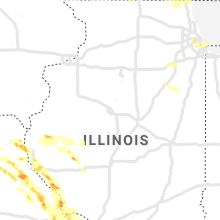
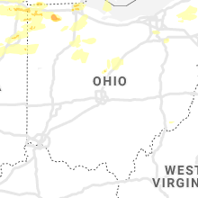
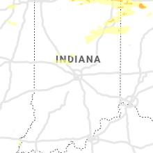
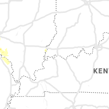
Hail Map for Saturday, June 1, 2019

Number of Impacted Households on 6/1/2019
0
Impacted by 1" or Larger Hail
0
Impacted by 1.75" or Larger Hail
0
Impacted by 2.5" or Larger Hail
Square Miles of Populated Area Impacted on 6/1/2019
0
Impacted by 1" or Larger Hail
0
Impacted by 1.75" or Larger Hail
0
Impacted by 2.5" or Larger Hail


Cities Most Affected by Hail Storms of 6/1/2019
| Hail Size | Demographics of Zip Codes Affected | ||||||
|---|---|---|---|---|---|---|---|
| City | Count | Average | Largest | Pop Density | House Value | Income | Age |
| Battle Creek, MI | 4 | 1.94 | 2.00 | 689 | $64k | $29.5k | 38.0 |
| Groom, TX | 4 | 1.81 | 2.00 | 1 | $53k | $35.7k | 47.8 |
| Artesia, NM | 3 | 2.17 | 2.75 | 13 | $65k | $31.3k | 35.1 |
| Satanta, KS | 2 | 1.75 | 1.75 | 2 | $62k | $37.0k | 35.3 |
| Garnett, KS | 2 | 1.75 | 1.75 | 23 | $62k | $34.1k | 41.2 |
| Fort Stockton, TX | 2 | 1.75 | 1.75 | 6 | $41k | $27.4k | 36.2 |
| Texline, TX | 1 | 2.75 | 2.75 | 1 | $44k | $33.6k | 33.2 |
| Fort Wayne, IN | 1 | 2.00 | 2.00 | 3203 | $68k | $32.9k | 34.1 |
| Goshen, IN | 1 | 2.00 | 2.00 | 452 | $103k | $44.6k | 34.4 |
| Blissfield, MI | 1 | 1.75 | 1.75 | 72 | $108k | $42.0k | 40.6 |
| Kincaid, KS | 1 | 1.75 | 1.75 | 6 | $28k | $32.4k | 46.4 |
| Channing, TX | 1 | 1.75 | 1.75 | 0 | $47k | $39.7k | 38.5 |
| Balch Springs, TX | 1 | 1.75 | 1.75 | 3248 | $57k | $37.2k | 28.7 |
| Aurora, CO | 1 | 1.75 | 1.75 | 997 | $406k | $114.5k | 36.8 |
| Saint Louis, MO | 1 | 1.75 | 1.75 | 4002 | $98k | $42.3k | 41.7 |
| Butler, IN | 1 | 1.75 | 1.75 | 63 | $76k | $41.3k | 37.2 |
| Sanger, TX | 1 | 1.75 | 1.75 | 111 | $91k | $48.0k | 36.4 |
| Montpelier, OH | 1 | 1.75 | 1.75 | 93 | $80k | $37.8k | 39.7 |
| Amarillo, TX | 1 | 1.75 | 1.75 | 3391 | $66k | $39.4k | 31.6 |
| Parma, MI | 1 | 1.75 | 1.75 | 92 | $116k | $48.5k | 41.1 |
| Florence, MO | 1 | 1.75 | 1.75 | 16 | $92k | $32.5k | 42.1 |
| Marshall, MI | 1 | 1.75 | 1.75 | 117 | $109k | $46.0k | 42.9 |
| Glendo, WY | 1 | 1.75 | 1.75 | 0 | $80k | $23.0k | 52.4 |
| S Coffeyville, OK | 1 | 1.75 | 1.75 | 8 | $48k | $35.5k | 42.0 |
| Edon, OH | 1 | 1.75 | 1.75 | 35 | $79k | $42.2k | 39.9 |
Hail and Wind Damage Spotted on 6/1/2019
Filter by Report Type:Hail ReportsWind Reports
States Impacted
Michigan, New Mexico, Florida, Oklahoma, Ohio, Wisconsin, Texas, Colorado, Kansas, Illinois, Pennsylvania, Indiana, Missouri, New York, Wyoming, North Carolina, UtahMichigan
| Local Time | Report Details |
|---|---|
| 11:00 AM EDT | Between 11 and 11:30 am june 1st... strong winds went through mason county downing large tree branches and uprooting several trees. the most concentrated damage was rep in mason county MI, 69.3 miles SW of Traverse City, MI |
| 12:40 PM EDT | Quarter sized hail reported near Albion, MI, 68.9 miles SE of Grand Rapids, MI, relayed via social media. time estimated by radar. |
| 12:53 PM EDT | Quarter sized hail reported near Parma, MI, 69.7 miles SW of Flint, MI, nickel to quarter size hail. relayed via social media. time estimated by radar. |
| 12:55 PM EDT | Golf Ball sized hail reported near Parma, MI, 69.3 miles SW of Flint, MI, delayed report. picture of 1.75 or slightly larger hailstone. relayed via social media. time estimated by radar. |
| 1:00 PM EDT | Quarter sized hail reported near Spring Arbor, MI, 71 miles SW of Flint, MI, time estimated from radar. |
| 1:48 PM EDT | Downed four inch tree limb in livingston county MI, 34.3 miles S of Flint, MI |
| 1:58 PM EDT | Quarter sized hail reported near Tecumseh, MI, 70.5 miles SSW of Flint, MI, quarter sized hail reported at occidental hwy and m-50. |
| 1:59 PM EDT | Tree reported down at calkins and linden rd in genesee county MI, 4.3 miles W of Flint, MI |
| 2:18 PM EDT | Several trees downed near green lak in oakland county MI, 32.3 miles SSE of Flint, MI |
| 2:21 PM EDT | Report of a tree down around crowe rd and sherman rd intersectio in monroe county MI, 65.6 miles S of Flint, MI |
| 2:22 PM EDT | Large tree limbs down roughly 8-12 inches in lengt in oakland county MI, 39.4 miles SSE of Flint, MI |
| 2:28 PM EDT | Half Dollar sized hail reported near Maybee, MI, 69.4 miles S of Flint, MI, reported at scofield and steffas rds. |
| 2:28 PM EDT | Large tree uprooted and fell on top of residents house on ludlow av in oakland county MI, 35.5 miles SE of Flint, MI |
| 2:31 PM EDT | Golf Ball sized hail reported near Blissfield, MI, 81.9 miles S of Flint, MI |
| 2:35 PM EDT | Rochester police reported numerous tree limbs downed and power outage in oakland county MI, 36.3 miles SE of Flint, MI |
| 2:40 PM EDT | Quarter sized hail reported near Monroe, MI, 76.8 miles SSE of Flint, MI |
| 2:41 PM EDT | Quarter sized hail reported near Clawson, MI, 42.9 miles SE of Flint, MI |
| 3:08 PM EDT | Reports of several trees and powerlines down in kimball twp and wales tw in st. clair county MI, 55.5 miles E of Flint, MI |
| 3:19 PM EDT | Report of downed tree that fell on top of hous in st. clair county MI, 61.5 miles E of Flint, MI |
| 3:20 PM EDT | Report of a metal roof torn off of a house/shed. size of structure unknow in st. clair county MI, 62.3 miles E of Flint, MI |
| 6:35 PM EDT | Hen Egg sized hail reported near Battle Creek, MI, 50.4 miles SSE of Grand Rapids, MI, 1.5 to 2 inch hail reported in downtown battle creek. |
| 6:35 PM EDT | Hen Egg sized hail reported near Battle Creek, MI, 51.8 miles SSE of Grand Rapids, MI, numerous photos of golf ball to tennis ball size hail. dented cars. damage to car windows and other property. |
| 6:39 PM EDT | Golf Ball sized hail reported near Battle Creek, MI, 52.1 miles SSE of Grand Rapids, MI |
| 6:40 PM EDT | Half Dollar sized hail reported near Battle Creek, MI, 53.6 miles SSE of Grand Rapids, MI, via mping. |
| 6:49 PM EDT | Hen Egg sized hail reported near Battle Creek, MI, 52.4 miles SSE of Grand Rapids, MI, up to 2.25 inch hail relayed via emergency management. |
| 7:15 PM EDT | Several trees blown down along lakeshore. time estimated by rada in allegan county MI, 32.2 miles SW of Grand Rapids, MI |
| 7:18 PM EDT | Golf Ball sized hail reported near Marshall, MI, 61.9 miles SE of Grand Rapids, MI |
| 7:32 PM EDT | Quarter sized hail reported near Marshall, MI, 60.2 miles SE of Grand Rapids, MI |
| 7:35 PM EDT | Trees down across all of allegan county. at least one tree fell on a house with several trees down on cars. time estimated by rada in allegan county MI, 31.5 miles SSW of Grand Rapids, MI |
| 7:50 PM EDT | Trees down on 12th street north of 136th ave. relayed via social media. time estimated by rada in allegan county MI, 19.8 miles S of Grand Rapids, MI |
| 7:55 PM EDT | Quarter sized hail reported near Camden, MI, 52.8 miles NNE of Fort Wayne, IN |
| 8:10 PM EDT | Numerous reports of large trees and power lines down in the city of hastings. time estimated by rada in barry county MI, 29.2 miles SE of Grand Rapids, MI |
| 8:10 PM EDT | Barry county dispatch reports trees and down across most of barry county. time estimated by rada in barry county MI, 33.5 miles SE of Grand Rapids, MI |
| 8:19 PM EDT | Quarter sized hail reported near Jonesville, MI, 74.7 miles NNE of Fort Wayne, IN, several reports of dime to quarter sized hail. |
| 8:22 PM EDT | Quarter sized hail reported near Mendon, MI, 67 miles S of Grand Rapids, MI |
| 8:26 PM EDT | Trees down around tow in eaton county MI, 40.4 miles SE of Grand Rapids, MI |
| 8:26 PM EDT | Trees down around tow in eaton county MI, 48.7 miles SE of Grand Rapids, MI |
| 8:31 PM EDT | Numerous trees down in and around charlott in eaton county MI, 50.7 miles ESE of Grand Rapids, MI |
| 8:43 PM EDT | Quarter sized hail reported near Sturgis, MI, 52.7 miles NNW of Fort Wayne, IN, half to 1 inch hail observed. |
| 9:15 PM EDT | Several reports of trees and power lines down in the pleasant lake area. time estimate by rada in jackson county MI, 55.1 miles SW of Flint, MI |
New Mexico
| Local Time | Report Details |
|---|---|
| 11:39 AM MDT | Quarter sized hail reported near Guadalupita, NM, 26.4 miles SE of Taos, NM |
| 11:49 AM MDT | Half Dollar sized hail reported near Guadalupita, NM, 26.4 miles SE of Taos, NM, via twitter |
| 12:18 PM MDT | Quarter sized hail reported near Cerrillos, NM, 33.5 miles NE of Albuquerque, NM, via twitter |
| 12:27 PM MDT | Quarter sized hail reported near Clayton, NM, 93 miles NNE of Tucumcari, NM |
| 12:34 PM MDT | Quarter sized hail reported near Clayton, NM, 93 miles NNE of Tucumcari, NM |
| 1:24 PM MDT | Kcvs aso in curry county NM, 59.3 miles SSE of Tucumcari, NM |
| 1:46 PM MDT | Storm damage reported in socorro county NM, 59.4 miles SSW of Albuquerque, NM |
| 2:05 PM MDT | Quarter sized hail reported near Alamogordo, NM, 75.2 miles NNE of El Paso, TX, via twitter video |
| 2:05 PM MDT | Quarter sized hail reported near Clayton, NM, 105.7 miles NNE of Tucumcari, NM |
| 4:23 PM MDT | Golf Ball sized hail reported near Artesia, NM, 46.8 miles S of Roswell, NM, golfball hail 9 miles south of artesia on us hwy 285 at mm 59. |
| 4:36 PM MDT | Quarter sized hail reported near Roswell, NM, 20.7 miles W of Roswell, NM |
| 4:52 PM MDT | Half Dollar sized hail reported near Artesia, NM, 46.8 miles S of Roswell, NM |
| 4:57 PM MDT | Hen Egg sized hail reported near Artesia, NM, 46.8 miles S of Roswell, NM, mile marker 59 on us highway 285 |
| 6:23 PM MDT | Baseball sized hail reported near Artesia, NM, 48.2 miles S of Roswell, NM, damage included busted windshield |
| 7:14 PM MDT | Melrose range raw in roosevelt county NM, 60.7 miles S of Tucumcari, NM |
| 7:23 PM MDT | Quarter sized hail reported near Lovington, NM, 74.6 miles ESE of Roswell, NM, minor street flooding |
| 7:24 PM MDT | Kcvs aso in curry county NM, 59.3 miles SSE of Tucumcari, NM |
| 7:30 PM MDT | Storm damage reported in curry county NM, 56.5 miles SSE of Tucumcari, NM |
Florida
| Local Time | Report Details |
|---|---|
| 1:17 PM CDT | Power company reported a couple of power lines down due to wind and trees blowing against the lines south of de funiak spring in walton county FL, 21.5 miles NE of Miramar Beach, FL |
| 3:38 PM EDT | Asos station kaaf apalachicol in franklin county FL, 66.4 miles SW of Tallahassee, FL |
| 3:49 PM EDT | Fallen trees or limbs resulted in a power outage along 17th street in apalachicola. reported on duke energy outage ma in franklin county FL, 65.7 miles SW of Tallahassee, FL |
Oklahoma
| Local Time | Report Details |
|---|---|
| 1:28 PM CDT | Twitter report in oklahoma county OK, 5.2 miles WNW of Oklahoma City, OK |
| 2:13 PM CDT | Large tree fallen on house at 4100 block of se 9th. relayed through nwscha in oklahoma county OK, 4.6 miles E of Oklahoma City, OK |
| 4:30 PM CDT | Golf Ball sized hail reported near S Coffeyville, OK, 53.3 miles S of Chanute, KS, time and location estimated by radar...second hand report via social media |
Ohio
| Local Time | Report Details |
|---|---|
| 3:02 PM EDT | Quarter sized hail reported near Toledo, OH, 88.1 miles ENE of Fort Wayne, IN, penny to quarter size hail. |
| 3:07 PM EDT | Quarter sized hail reported near Maumee, OH, 82 miles ENE of Fort Wayne, IN |
| 3:12 PM EDT | Quarter sized hail reported near Toledo, OH, 84.7 miles ENE of Fort Wayne, IN, trained spotter reported one inch hail at swan creek metropark. |
| 3:13 PM EDT | Ping Pong Ball sized hail reported near Toledo, OH, 85.8 miles ENE of Fort Wayne, IN, a member of the public measured 1.5 inch hail on the northeast side of maumee. |
| 3:16 PM EDT | Ping Pong Ball sized hail reported near Toledo, OH, 87.5 miles ENE of Fort Wayne, IN, a member of the public measured 1.5 inch hail on the south side of toledo. |
| 3:18 PM EDT | Quarter sized hail reported near Toledo, OH, 87.5 miles ENE of Fort Wayne, IN, reported at toledo zoo. |
| 3:19 PM EDT | Quarter sized hail reported near Rossford, OH, 88.1 miles ENE of Fort Wayne, IN, reported in rossford. |
| 3:31 PM EDT | Quarter sized hail reported near Perrysburg, OH, 84.1 miles ENE of Fort Wayne, IN, trained spotter reported quarter sized hail on willow lane in perrysburg. |
| 4:24 PM EDT | Quarter sized hail reported near Kinsman, OH, 57.8 miles E of Cleveland, OH |
| 4:30 PM EDT | Quarter sized hail reported near Gibsonburg, OH, 85 miles W of Cleveland, OH |
| 4:45 PM EDT | Quarter sized hail reported near Cygnet, OH, 76.9 miles E of Fort Wayne, IN, reported in cygnet ohio. |
| 4:56 PM EDT | Golf Ball sized hail reported near Edon, OH, 41.5 miles NNE of Fort Wayne, IN |
| 4:57 PM EDT | Report of a tree down on a house on concord ave. tree fell with winds from outflow ahead of thunderstor in lorain county OH, 22.3 miles WSW of Cleveland, OH |
| 5:02 PM EDT | Quarter sized hail reported near Canal Fulton, OH, 42.8 miles S of Cleveland, OH, social media report of quarter sized hail in canal fulton. |
| 5:14 PM EDT | Golf Ball sized hail reported near Montpelier, OH, 43.4 miles NE of Fort Wayne, IN, nickle to golf ball sized hail observed-several reports. |
| 5:14 PM EDT | Quarter sized hail reported near Montpelier, OH, 43.7 miles NE of Fort Wayne, IN |
| 5:28 PM EDT | Ping Pong Ball sized hail reported near Bryan, OH, 44.4 miles NE of Fort Wayne, IN |
| 5:40 PM EDT | Quarter sized hail reported near Napoleon, OH, 55.8 miles ENE of Fort Wayne, IN |
| 5:53 PM EDT | Quarter sized hail reported near Bryan, OH, 41.2 miles NE of Fort Wayne, IN |
| 6:00 PM EDT | Quarter sized hail reported near North Bloomfield, OH, 42.7 miles E of Cleveland, OH, trained spotter reported quarter sized hail in north bloomfield. |
| 6:05 PM EDT | Quarter sized hail reported near Napoleon, OH, 54.7 miles ENE of Fort Wayne, IN |
| 6:30 PM EDT | Quarter sized hail reported near Findlay, OH, 75.2 miles E of Fort Wayne, IN |
| 6:48 PM EDT | Quarter sized hail reported near Archbold, OH, 53.8 miles NE of Fort Wayne, IN |
| 7:18 PM EDT | Quarter sized hail reported near Mc Cutchenville, OH, 73.8 miles NNW of Columbus, OH, quarter-sized hail on 587 just outside mccutchensville. |
| 7:32 PM EDT | Quarter sized hail reported near Cardington, OH, 37.6 miles N of Columbus, OH, photo on social media of quarter sized hail in cardington. |
| 8:21 PM EDT | Ping Pong Ball sized hail reported near Hicksville, OH, 22.7 miles NE of Fort Wayne, IN |
| 1:16 AM EDT | Corrects previous tstm wnd dmg report from 1 n marion. tree down blocking n prospect roa in marion county OH, 44.5 miles N of Columbus, OH |
| 1:16 AM EDT | Tree down in mount gilead reported via faceboo in morrow county OH, 41.5 miles NNE of Columbus, OH |
| 1:16 AM EDT | Trees and powerlines down reported via faceboo in marion county OH, 43.7 miles N of Columbus, OH |
| 1:30 AM EDT | Tree down blocking n prospect roa in marion county OH, 44.5 miles N of Columbus, OH |
| 1:51 AM EDT | Quarter sized hail reported near Fredericktown, OH, 45.7 miles NNE of Columbus, OH |
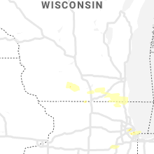
Wisconsin
| Local Time | Report Details |
|---|---|
| 2:30 PM CDT | Half Dollar sized hail reported near New Glarus, WI, 23.1 miles SSW of Madison, WI |
| 3:15 PM CDT | Quarter sized hail reported near Janesville, WI, 31.8 miles SSE of Madison, WI, relayed via broadcast media. |
| 3:50 PM CDT | Half Dollar sized hail reported near Lake Geneva, WI, 59.2 miles ESE of Madison, WI, picture via twitter. |
Texas
| Local Time | Report Details |
|---|---|
| 3:05 PM CDT | Baseball sized hail reported near Texline, TX, 89.6 miles NNE of Tucumcari, NM |
| 4:50 PM CDT | Ping Pong Ball sized hail reported near Pecos, TX, 57.4 miles N of Alpine, TX, quarter to ping pong size hail |
| 5:11 PM CDT | Downed power lines on old agnes road. time estimated using rada in parker county TX, 58.5 miles W of Dallas, TX |
| 5:42 PM CDT | Quarter sized hail reported near , , 60.6 miles NNE of Alpine, TX |
| 5:46 PM CDT | Quarter sized hail reported near Mentone, TX, 72.7 miles W of Odessa, TX |
| 5:48 PM CDT | Half Dollar sized hail reported near Channing, TX, 46.7 miles NW of Amarillo, TX |
| 5:48 PM CDT | Roof damage to early education center in kru in denton county TX, 43 miles NW of Dallas, TX |
| 5:50 PM CDT | Half Dollar sized hail reported near Mentone, TX, 72.7 miles W of Odessa, TX |
| 5:53 PM CDT | Ping Pong Ball sized hail reported near Channing, TX, 50.1 miles NW of Amarillo, TX |
| 6:00 PM CDT | Estimated 60 mph wind gust in sange in denton county TX, 46.5 miles NNW of Dallas, TX |
| 6:04 PM CDT | Quarter sized hail reported near Channing, TX, 46.8 miles NNW of Amarillo, TX |
| 6:13 PM CDT | Quarter sized hail reported near Sanger, TX, 46.5 miles NNW of Dallas, TX, one-inch hail reported in sanger. |
| 6:15 PM CDT | Golf Ball sized hail reported near Sanger, TX, 45.3 miles NNW of Dallas, TX, golf ball size hail reported near sanger. |
| 6:19 PM CDT | Quarter sized hail reported near Sanger, TX, 46.5 miles NNW of Dallas, TX, quarter size hail reported at marion road and fm-455. |
| 6:23 PM CDT | Quarter sized hail reported near Dallas, TX, 1.1 miles ESE of Dallas, TX, quarter size hail in oak lawn. |
| 6:37 PM CDT | Golf Ball sized hail reported near Fort Stockton, TX, 58.8 miles NE of Alpine, TX, fm 1776 about 2 miles north of highway 285 |
| 6:43 PM CDT | Golf Ball sized hail reported near Channing, TX, 43 miles NW of Amarillo, TX |
| 6:52 PM CDT | 80 mph gust measured by hams. multiple large tree limbs down 10-24" diameter. possible brief tornado in dallas county TX, 18.5 miles ESE of Dallas, TX |
| 6:56 PM CDT | Golf Ball sized hail reported near Balch Springs, TX, 10.4 miles ESE of Dallas, TX, golf ball size hail reported in balch springs. |
| 6:57 PM CDT | Golf Ball sized hail reported near Fort Stockton, TX, 58.6 miles NE of Alpine, TX, highway 285 and west gomez road |
| 6:58 PM CDT | Quarter sized hail reported near Fort Stockton, TX, 62 miles NE of Alpine, TX |
| 7:03 PM CDT | Storm damage reported in oldham county TX, 33.2 miles NW of Amarillo, TX |
| 7:04 PM CDT | Ping Pong Ball sized hail reported near Fort Stockton, TX, 62 miles NE of Alpine, TX |
| 7:09 PM CDT | Quarter sized hail reported near Fort Stockton, TX, 58.9 miles NE of Alpine, TX, fm 1053 |
| 7:13 PM CDT | Quarter sized hail reported near Panhandle, TX, 24.9 miles ENE of Amarillo, TX |
| 7:38 PM CDT | Golf Ball sized hail reported near Groom, TX, 30.8 miles E of Amarillo, TX, hail currently falling on i-40 at mile marker 102. |
| 7:42 PM CDT | Hen Egg sized hail reported near Groom, TX, 31.3 miles E of Amarillo, TX |
| 7:50 PM CDT | Time estimated based dispatch call. 3 oak trees uprooted and barn moved about 100 yards from foundation near hwy59 in jack county TX, 48.7 miles SSE of Wichita Falls, TX |
| 7:51 PM CDT | Ping Pong Ball sized hail reported near Fort Stockton, TX, 58.9 miles NE of Alpine, TX, northwest side of town |
| 7:54 PM CDT | Storm damage reported in randall county TX, 9.8 miles SW of Amarillo, TX |
| 7:58 PM CDT | Golf Ball sized hail reported near Amarillo, TX, 5.6 miles SW of Amarillo, TX |
| 8:00 PM CDT | Golf Ball sized hail reported near Groom, TX, 29.7 miles E of Amarillo, TX |
| 8:01 PM CDT | Golf Ball sized hail reported near Groom, TX, 33 miles E of Amarillo, TX |
| 8:04 PM CDT | Storm damage reported in randall county TX, 7 miles SSE of Amarillo, TX |
| 8:05 PM CDT | A power pole reported down along with sporadic tree damag in archer county TX, 23.2 miles SSW of Wichita Falls, TX |
| 8:12 PM CDT | Quarter sized hail reported near Amarillo, TX, 0.9 miles ESE of Amarillo, TX, 10th and eastern |
| 8:15 PM CDT | Storm damage reported in randall county TX, 7 miles SSE of Amarillo, TX |
| 8:49 PM CDT | Storm damage reported in armstrong county TX, 24.6 miles SE of Amarillo, TX |
| 8:55 PM CDT | Storm damage reported in armstrong county TX, 24.6 miles SE of Amarillo, TX |
| 9:06 PM CDT | Reports of 3-6" diameter tree limbs down near emhouse to corsicana. time estimated based on radar in navarro county TX, 48.1 miles SSE of Dallas, TX |
| 9:24 PM CDT | Deputy reports 60 mph wind gusts on hwy287 just south of i-45 in navarro county TX, 53 miles SSE of Dallas, TX |
| 3:11 AM CDT | Storm damage reported in shackelford county TX, 32.2 miles NE of Abilene, TX |
| 3:20 AM CDT | Roof blown off of a residence just northwest of breckenridge. time estimated via rada in stephens county TX, 51.6 miles ENE of Abilene, TX |
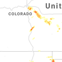
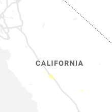
Colorado
| Local Time | Report Details |
|---|---|
| 2:18 PM MDT | Quarter sized hail reported near Englewood, CO, 11.4 miles SE of Denver, CO |
| 2:35 PM MDT | Quarter sized hail reported near Aurora, CO, 8.4 miles ESE of Denver, CO, hail accumulated to 2 inches deep. |
| 2:41 PM MDT | Golf Ball sized hail reported near Aurora, CO, 18.7 miles SE of Denver, CO |
| 2:44 PM MDT | Ping Pong Ball sized hail reported near Aurora, CO, 20 miles ESE of Denver, CO |
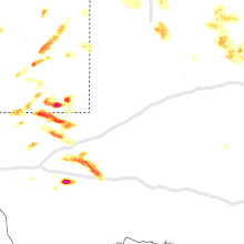
Kansas
| Local Time | Report Details |
|---|---|
| 3:21 PM CDT | Half Dollar sized hail reported near Ottawa, KS, 46.7 miles SW of Kansas City, MO |
| 3:44 PM CDT | Quarter sized hail reported near Shawnee, KS, 10.2 miles SW of Kansas City, MO |
| 3:47 PM CDT | Quarter sized hail reported near Shawnee, KS, 8.9 miles SW of Kansas City, MO |
| 3:50 PM CDT | Quarter sized hail reported near Ottawa, KS, 43.3 miles SW of Kansas City, MO |
| 3:55 PM CDT | Quarter sized hail reported near Kansas City, KS, 5.3 miles W of Kansas City, MO |
| 3:55 PM CDT | Quarter sized hail reported near Shawnee, KS, 9.8 miles SW of Kansas City, MO |
| 3:57 PM CDT | Quarter sized hail reported near Kansas City, KS, 3.3 miles SSW of Kansas City, MO |
| 3:58 PM CDT | Quarter sized hail reported near Kansas City, KS, 3.9 miles SW of Kansas City, MO |
| 4:00 PM CDT | Half Dollar sized hail reported near Kansas City, KS, 3.2 miles WSW of Kansas City, MO |
| 4:05 PM CDT | Quarter sized hail reported near Rantoul, KS, 44.5 miles SW of Kansas City, MO |
| 4:12 PM CDT | Quarter sized hail reported near Olathe, KS, 19.6 miles SW of Kansas City, MO, mping report. |
| 4:22 PM CDT | Quarter sized hail reported near Olathe, KS, 19 miles SSW of Kansas City, MO, 149th and pflumm. |
| 4:25 PM CDT | Quarter sized hail reported near Olathe, KS, 22.2 miles SSW of Kansas City, MO |
| 4:48 PM CDT | Estimated 60 mph winds near the intersection of hwy 152 and hwy 6 in linn county KS, 52.2 miles S of Kansas City, MO |
| 4:49 PM CDT | Golf Ball sized hail reported near Garnett, KS, 39.7 miles N of Chanute, KS |
| 4:57 PM CDT | Golf Ball sized hail reported near Garnett, KS, 39.5 miles NNE of Chanute, KS |
| 5:00 PM CDT | Estimated 60 mph currently ongoing near the intersection of hwy 52 and hwy 6 in linn county KS, 58.3 miles S of Kansas City, MO |
| 5:04 PM CDT | Ping Pong Ball sized hail reported near Garnett, KS, 39.4 miles NNE of Chanute, KS, a few 1.5 inch hail stones with lots of quarter size hail. |
| 5:05 PM CDT | Quarter sized hail reported near Pleasanton, KS, 57.7 miles S of Kansas City, MO |
| 5:30 PM CDT | Golf Ball sized hail reported near Kincaid, KS, 36.2 miles NNE of Chanute, KS, at least golfball size hail... may be slightly larger. |
| 5:47 PM CDT | Quarter sized hail reported near Iola, KS, 17.9 miles N of Chanute, KS, relayed by dispatch. |
| 5:48 PM CDT | Quarter sized hail reported near Colony, KS, 27.9 miles N of Chanute, KS |
| 5:56 PM CDT | Quarter sized hail reported near Blue Mound, KS, 34.8 miles NE of Chanute, KS |
| 5:57 PM CDT | Quarter sized hail reported near Kincaid, KS, 33.5 miles NNE of Chanute, KS |
| 6:00 PM CDT | Golf Ball sized hail reported near Satanta, KS, 35.9 miles SSW of Garden City, KS |
| 6:05 PM CDT | Golf Ball sized hail reported near Satanta, KS, 37.3 miles SSW of Garden City, KS, time was estimated based on radar. |
| 7:08 PM CDT | Quarter sized hail reported near Elsmore, KS, 18.9 miles ENE of Chanute, KS, via social media. |
| 7:34 PM CDT | Quarter sized hail reported near Savonburg, KS, 17.7 miles ENE of Chanute, KS |
| 8:05 PM CDT | Dime size hail occurred before severe wind gus in neosho county KS, 17.1 miles E of Chanute, KS |
| 8:24 PM CDT | Ping Pong Ball sized hail reported near Cherokee, KS, 42 miles SE of Chanute, KS, ping pong ball sized hail. |
| 8:24 PM CDT | Corrects previous tstm wnd gst report from 1 wsw cherokee. estimated 50-60 mph wind gust in crawford county KS, 41.7 miles ESE of Chanute, KS |
| 8:24 PM CDT | Estimated 50-60 mph wind gust in crawford county KS, 42 miles SE of Chanute, KS |
| 8:24 PM CDT | Ping Pong Ball sized hail reported near Cherokee, KS, 41.7 miles ESE of Chanute, KS, ping pong ball sized hail. |
Illinois
| Local Time | Report Details |
|---|---|
| 3:31 PM CDT | Quarter sized hail reported near Antioch, IL, 46.1 miles NNW of Chicago, IL |
| 3:35 PM CDT | Ping Pong Ball sized hail reported near Berwyn, IL, 8.7 miles WSW of Chicago, IL, corrects previous hail report from berwyn. relayed via social media. |
| 3:42 PM CDT | Half Dollar sized hail reported near Berwyn, IL, 8.7 miles WSW of Chicago, IL, relayed via social media. |
| 3:57 PM CDT | Half Dollar sized hail reported near Oak Park, IL, 8.7 miles W of Chicago, IL, photo shared via social media of hail slightly larger than quarter sized. |
| 4:12 PM CDT | Quarter sized hail reported near Ursa, IL, 22.3 miles SSE of Kahoka, MO |
| 4:13 PM CDT | Quarter sized hail reported near Chicago, IL, 10.7 miles SSW of Chicago, IL, duration of hail 2 min... largest size 1 inch. |
| 4:35 PM CDT | Quarter sized hail reported near Spring Grove, IL, 48.1 miles NW of Chicago, IL |
| 5:19 PM CDT | Quarter sized hail reported near Hull, IL, 56.3 miles SSE of Kahoka, MO |
| 5:40 PM CDT | Quarter sized hail reported near Augusta, IL, 42.7 miles ESE of Kahoka, MO, pea size and quarter size hail. |
| 6:30 PM CDT | Quarter sized hail reported near Payson, IL, 44.6 miles SSE of Kahoka, MO, delayed report. photo posted to social media. hail appears to be between 1 and 1.25 inches in diameter. hail fell between quincy and payson on hwy 96. |
| 8:44 PM CDT | Quarter sized hail reported near Dupo, IL, 7.5 miles S of Saint Louis, MO, st. clair il em reports quarter hail in dupo. |
Pennsylvania
| Local Time | Report Details |
|---|---|
| 4:35 PM EDT | Trees down at minister creek campground in forest county PA, 88.1 miles NW of State College, PA |
| 4:43 PM EDT | Trees down along route 666 in forest county PA, 83.3 miles NW of State College, PA |
| 5:22 PM EDT | Ping Pong Ball sized hail reported near Atlantic, PA, 74.4 miles N of Pittsburgh, PA, report of 1.5 inch hail at the intersection of lake road and powder road... east of adamsville. |
| 5:45 PM EDT | Tree down on west 4th and cranberry - time estimated by rada in erie county PA, 82.1 miles SW of Buffalo, NY |
| 5:50 PM EDT | Large tree downed... blocking portions of state street... near w 38th stree in erie county PA, 81.5 miles SW of Buffalo, NY |
| 5:54 PM EDT | *** 1 inj *** corrects previous tstm wnd dmg report from 2 sw wesleyville... large tree limb fell on man working in yard on e 36th stree in erie county PA, 79.9 miles SW of Buffalo, NY |
| 5:55 PM EDT | Large tree branch fell and snapped a telephone pol in erie county PA, 77.5 miles SW of Buffalo, NY |
| 5:55 PM EDT | Roof damage to home in waterford with picture on twitte in erie county PA, 86.9 miles SW of Buffalo, NY |
| 5:56 PM EDT | Trees down in mercer county PA, 62.4 miles NNW of Pittsburgh, PA |
| 6:00 PM EDT | Trees down in sandy lake / stoneboro area in mercer county PA, 63.1 miles N of Pittsburgh, PA |
| 6:00 PM EDT | Crawford county sheriff dispatch reports numerous trees down across the county. several trees fell onto power lines and sparked fires in a few cases. general time of wi in crawford county PA, 86 miles ENE of Cleveland, OH |
| 6:12 PM EDT | Large tree uprooted in union city with picture on twitte in erie county PA, 83.6 miles SW of Buffalo, NY |
| 6:18 PM EDT | Downed power pole and tree in corry with pictures on faceboo in erie county PA, 77.2 miles SSW of Buffalo, NY |
| 6:18 PM EDT | Multiple trees down near brown hill road and rockdale road in union city. reported via facebook with picture in crawford county PA, 92.2 miles SW of Buffalo, NY |
| 6:25 PM EDT | Trees down in venango county PA, 70.2 miles NNE of Pittsburgh, PA |
Indiana
| Local Time | Report Details |
|---|---|
| 4:35 PM EDT | Large limb... around 6 inches in diameter downe in st. joseph county IN, 69.9 miles ESE of Chicago, IL |
| 4:35 PM EDT | Half Dollar sized hail reported near South Bend, IN, 69.9 miles ESE of Chicago, IL |
| 4:36 PM EDT | Ping Pong Ball sized hail reported near Pleasant Lake, IN, 35.6 miles N of Fort Wayne, IN |
| 4:36 PM EDT | Quarter sized hail reported near South Bend, IN, 71.8 miles E of Chicago, IL |
| 4:36 PM EDT | Ping Pong Ball sized hail reported near Angola, IN, 38.6 miles N of Fort Wayne, IN, several reports of dime to ping pong sized hail around angola. |
| 4:40 PM EDT | Quarter sized hail reported near South Bend, IN, 70.9 miles WNW of Fort Wayne, IN |
| 4:43 PM EDT | Half Dollar sized hail reported near South Bend, IN, 70.7 miles ESE of Chicago, IL |
| 5:12 PM EDT | Quarter sized hail reported near Goshen, IN, 53.4 miles NW of Fort Wayne, IN |
| 5:23 PM EDT | Quarter sized hail reported near Goshen, IN, 54.4 miles NW of Fort Wayne, IN |
| 5:41 PM EDT | Quarter sized hail reported near Lagrange, IN, 42.8 miles NNW of Fort Wayne, IN |
| 6:52 PM EDT | Quarter sized hail reported near Butler, IN, 28.2 miles NNE of Fort Wayne, IN |
| 7:03 PM EDT | Golf Ball sized hail reported near Butler, IN, 27.2 miles NNE of Fort Wayne, IN, ping pong to golf ball sized hail observed. |
| 8:35 PM EDT | Hen Egg sized hail reported near Goshen, IN, 51.9 miles NW of Fort Wayne, IN, 1 to 2 inch hail reported by several spotters. |
| 9:46 PM EDT | Half Dollar sized hail reported near Fort Wayne, IN, 4.5 miles WNW of Fort Wayne, IN, wpta abc 21 station. quarter to half dollar sized hail. |
| 9:48 PM EDT | Hen Egg sized hail reported near Fort Wayne, IN, 3.5 miles NNW of Fort Wayne, IN |
| 9:52 PM EDT | Quarter sized hail reported near Fort Wayne, IN, 2.2 miles W of Fort Wayne, IN, numerous reports of dime to quarter sized hail from around fort wayne. |
| 10:13 PM EDT | Quarter sized hail reported near Fort Wayne, IN, 3.1 miles N of Fort Wayne, IN |
| 10:15 PM EDT | Quarter sized hail reported near Fort Wayne, IN, 5.5 miles NNE of Fort Wayne, IN |
| 10:17 PM EDT | Quarter sized hail reported near Fort Wayne, IN, 6.1 miles NE of Fort Wayne, IN |
| 10:25 PM EDT | Tree down and damaged a house. time estimated by rada in huntington county IN, 27 miles SW of Fort Wayne, IN |
| 10:30 PM EDT | Tree down and blocking road. time estimated by rada in huntington county IN, 25.5 miles SW of Fort Wayne, IN |
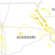
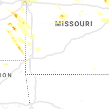
Missouri
| Local Time | Report Details |
|---|---|
| 4:04 PM CDT | Quarter sized hail reported near Kansas City, MO, 4.3 miles S of Kansas City, MO, 41 action news studio. report received via twitter. |
| 4:07 PM CDT | Quarter sized hail reported near Kansas City, MO, 1.6 miles SSW of Kansas City, MO, delayed report from twitter. report came from liberty memorial. |
| 4:12 PM CDT | Quarter sized hail reported near Kansas City, MO, 2.4 miles SSE of Kansas City, MO |
| 4:15 PM CDT | Quarter sized hail reported near Kansas City, MO, 5.8 miles ESE of Kansas City, MO |
| 4:24 PM CDT | Quarter sized hail reported near Independence, MO, 8.2 miles E of Kansas City, MO |
| 4:24 PM CDT | Ping Pong Ball sized hail reported near La Grange, MO, 28.7 miles SSE of Kahoka, MO |
| 4:30 PM CDT | Quarter sized hail reported near Independence, MO, 11 miles E of Kansas City, MO, mping report. |
| 4:30 PM CDT | Half Dollar sized hail reported near Canton, MO, 26.2 miles SSE of Kahoka, MO |
| 4:32 PM CDT | Half Dollar sized hail reported near La Grange, MO, 28.7 miles SSE of Kahoka, MO, quarter to half dollar size hail... has been hailing for at least 5 minutes. |
| 5:42 PM CDT | Delayed report from social media. large tree down in rich hill. time-matched to rada in bates county MO, 66.3 miles ENE of Chanute, KS |
| 5:50 PM CDT | Farm outbuilding partial collapse. picture via social media. time estimated from rada in vernon county MO, 59 miles ENE of Chanute, KS |
| 5:52 PM CDT | Estimated at least 60 mph winds north of nevada. large hail also... size unknow in vernon county MO, 63.8 miles ENE of Chanute, KS |
| 5:54 PM CDT | Corrects previous tstm wnd dmg report from 1 ssw horton. tree down on route d near interstate 4 in vernon county MO, 62 miles ENE of Chanute, KS |
| 5:57 PM CDT | Quarter sized hail reported near Shelbina, MO, 51.9 miles SSW of Kahoka, MO, shelbina fire reports a lot of quarter sized hail 5 miles east of shelbina. many people on the road have pulled over to wait it out. |
| 6:10 PM CDT | Power line and trees down in nevad in vernon county MO, 61.3 miles E of Chanute, KS |
| 6:11 PM CDT | Estimated 70 mph wind gust in the sulphur springs are in vernon county MO, 63 miles NW of Springfield, MO |
| 6:12 PM CDT | Tree down in schell cit in vernon county MO, 72.1 miles NW of Springfield, MO |
| 6:16 PM CDT | Estimated 50-60 mph wind gusts in the moundville are in vernon county MO, 55.2 miles E of Chanute, KS |
| 6:24 PM CDT | Estimated 60mph wind gust in vernon county MO, 62.6 miles E of Chanute, KS |
| 6:44 PM CDT | Corrects previous tstm wnd gst report from 4 n kenoma. estimated 60 mph winds and small broken limbs 5 miles east of lamar on hwy 16 in barton county MO, 53.4 miles WNW of Springfield, MO |
| 6:52 PM CDT | Tree down near route d and interstate 4 in vernon county MO, 62 miles ENE of Chanute, KS |
| 7:03 PM CDT | Trained spotter reports dime size hail and winds sufficient to snap 1 inch diameter tree limb in lincoln county MO, 49.1 miles NW of Saint Louis, MO |
| 7:22 PM CDT | Large tree blown down onto highway 154 just east of intersection with idaho roa in ralls county MO, 47.6 miles NE of Columbia, MO |
| 7:32 PM CDT | Shutter blown off of a window on a hous in lincoln county MO, 47.6 miles WNW of Saint Louis, MO |
| 7:40 PM CDT | Tree limbs blown down onto mcclay roa in st. charles county MO, 23 miles WNW of Saint Louis, MO |
| 7:55 PM CDT | Quarter sized hail reported near Stover, MO, 59.4 miles SW of Columbia, MO, quarter sized hail. |
| 7:58 PM CDT | Quarter sized hail reported near Maryland Heights, MO, 15.1 miles WNW of Saint Louis, MO, near the intersection of mckelvey and creve coeur mill road. |
| 8:00 PM CDT | Extensive damage reported in the portage des sioux are in st. charles county MO, 22.2 miles NNW of Saint Louis, MO |
| 8:01 PM CDT | Several large tree limbs blown down near the intersection of i-270 and lindbergh blv in st. louis county MO, 14 miles NW of Saint Louis, MO |
| 8:03 PM CDT | Quarter sized hail reported near Florissant, MO, 13.8 miles NNW of Saint Louis, MO |
| 8:04 PM CDT | Numerous large tree limbs down around the neighborhoo in st. louis county MO, 13.8 miles NNW of Saint Louis, MO |
| 8:18 PM CDT | Quarter sized hail reported near Wentzville, MO, 37.8 miles WNW of Saint Louis, MO |
| 8:18 PM CDT | Golf Ball sized hail reported near Florence, MO, 42.9 miles SW of Columbia, MO, golf ball sized hail in florence. time estimated from radar. |
| 8:22 PM CDT | Pea sized hail along with the 60 mph gust estimat in st. charles county MO, 33 miles WNW of Saint Louis, MO |
| 8:25 PM CDT | Quarter sized hail reported near Otterville, MO, 41 miles WSW of Columbia, MO, mping report of quarter sized hail. |
| 8:30 PM CDT | Quarter sized hail reported near O Fallon, MO, 30.1 miles WNW of Saint Louis, MO |
| 8:30 PM CDT | Golf Ball sized hail reported near Saint Louis, MO, 8.9 miles SW of Saint Louis, MO |
| 8:38 PM CDT | Quarter sized hail reported near Saint Louis, MO, 8 miles SSW of Saint Louis, MO |
| 8:46 PM CDT | Quarter sized hail reported near Chesterfield, MO, 21.3 miles W of Saint Louis, MO |
| 11:38 PM CDT | Delayed report: bismark fire dept reported that several trees were down in the iron mountain lake subdivision... extending from the northwest side near mallard and 2nd in st. francois county MO, 50.3 miles E of Salem, MO |
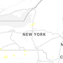
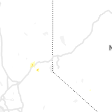
New York
| Local Time | Report Details |
|---|---|
| 6:11 PM EDT | Multiple reports of trees and wires dow in chautauqua county NY, 46.1 miles SSW of Buffalo, NY |
| 6:12 PM EDT | Multiple reports of trees and wires dow in chautauqua county NY, 54.5 miles SSW of Buffalo, NY |
| 6:27 PM EDT | Multiple reports of trees and wires down. tree down on north main s in chautauqua county NY, 57.3 miles SSW of Buffalo, NY |
Wyoming
| Local Time | Report Details |
|---|---|
| 6:05 PM MDT | Golf Ball sized hail reported near Glendo, WY, 74.4 miles NW of Scottsbluff, NE, late social media report of ping pong to golf ball sized hail with photos and video. time estimated based on radar. |
| 8:13 PM MDT | Ping Pong Ball sized hail reported near Newcastle, WY, 58.9 miles SE of Gillette, WY, quarter to ping pong ball sized hail |
| 8:30 PM MDT | Quarter sized hail reported near Newcastle, WY, 61.4 miles SE of Gillette, WY, time estimated from radar |
North Carolina
| Local Time | Report Details |
|---|---|
| 10:08 PM EDT | Tree down on stony ridge rd in pinnacle. time estimated from rada in surry county NC, 73.4 miles SSW of Roanoke, VA |
Utah
| Local Time | Report Details |
|---|---|
| 9:00 PM MDT | Mp 79 on i-80 in tooele county UT, 37.3 miles W of Salt Lake City, UT |
Connect with Interactive Hail Maps