

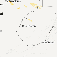
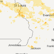
Hail Map for Friday, June 17, 2011

Number of Impacted Households on 6/17/2011
0
Impacted by 1" or Larger Hail
0
Impacted by 1.75" or Larger Hail
0
Impacted by 2.5" or Larger Hail
Square Miles of Populated Area Impacted on 6/17/2011
0
Impacted by 1" or Larger Hail
0
Impacted by 1.75" or Larger Hail
0
Impacted by 2.5" or Larger Hail


Cities Most Affected by Hail Storms of 6/17/2011
| Hail Size | Demographics of Zip Codes Affected | ||||||
|---|---|---|---|---|---|---|---|
| City | Count | Average | Largest | Pop Density | House Value | Income | Age |
| Hutchinson, KS | 4 | 1.75 | 1.75 | 158 | $58k | $33.0k | 36.7 |
| Cedar Bluffs, NE | 3 | 1.83 | 2.00 | 10 | $74k | $36.8k | 43.8 |
| Hope, KS | 3 | 1.83 | 2.00 | 5 | $43k | $31.2k | 48.2 |
| Scott City, KS | 3 | 1.83 | 2.00 | 6 | $72k | $40.5k | 41.5 |
| Potwin, KS | 2 | 2.25 | 2.75 | 5 | $43k | $40.9k | 41.6 |
| Madison, VA | 2 | 1.75 | 1.75 | 46 | $104k | $39.6k | 43.9 |
| Inman, KS | 1 | 2.00 | 2.00 | 12 | $84k | $41.3k | 45.4 |
| Herington, KS | 1 | 2.00 | 2.00 | 21 | $44k | $31.4k | 42.2 |
| Mcpherson, KS | 1 | 1.75 | 1.75 | 67 | $86k | $42.0k | 39.9 |
| Bennington, KS | 1 | 1.75 | 1.75 | 16 | $80k | $45.3k | 41.4 |
| Lyons, KS | 1 | 1.75 | 1.75 | 23 | $46k | $35.8k | 40.0 |
| Eureka, KS | 1 | 1.75 | 1.75 | 8 | $39k | $29.2k | 44.8 |
| Plain City, OH | 1 | 1.75 | 1.75 | 123 | $141k | $50.9k | 39.0 |
| New Canton, VA | 1 | 1.75 | 1.75 | 37 | $75k | $31.8k | 44.9 |
| Wahoo, NE | 1 | 1.75 | 1.75 | 58 | $87k | $36.5k | 39.6 |
| Mc Clave, CO | 1 | 1.75 | 1.75 | 6 | $71k | $30.5k | 38.4 |
| Karval, CO | 1 | 1.75 | 1.75 | 0 | $40k | $29.5k | 46.4 |
| Garden City, KS | 1 | 1.75 | 1.75 | 44 | $85k | $38.1k | 30.2 |
| Hilliard, OH | 1 | 1.75 | 1.75 | 1681 | $144k | $61.7k | 33.6 |
| Sheridan Lake, CO | 1 | 1.75 | 1.75 | 1 | $25k | $30.7k | 38.8 |
| Reva, VA | 1 | 1.75 | 1.75 | 66 | $107k | $38.8k | 41.7 |
| Dodge City, KS | 1 | 1.75 | 1.75 | 82 | $71k | $37.6k | 29.5 |
| Scottsville, VA | 1 | 1.75 | 1.75 | 45 | $102k | $39.0k | 41.0 |
| Peyton, CO | 1 | 1.75 | 1.75 | 127 | $173k | $54.4k | 36.2 |
| El Dorado, KS | 1 | 1.75 | 1.75 | 63 | $66k | $35.2k | 35.5 |
| Hays, KS | 1 | 1.75 | 1.75 | 62 | $91k | $32.5k | 30.5 |
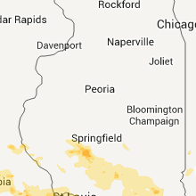
Hail and Wind Damage Spotted on 6/17/2011
Filter by Report Type:Hail ReportsWind Reports
States Impacted
Illinois, Missouri, Kansas, North Carolina, Alabama, Virginia, West Virginia, Colorado, Ohio, Georgia, Florida, Maryland, New Jersey, New York, Minnesota, Kentucky, Nebraska, Iowa, New MexicoIllinois
| Local Time | Report Details |
|---|---|
| 12:18 PM UTC | Half Dollar sized hail reported near Metropolis, IL, 45.3 miles E of Cape Girardeau, MO |
| 5:15 PM UTC | Widespread tree damage across the city. additionally power lines snapped due to falling limb in monroe county IL, 11.7 miles S of Saint Louis, MO |
| 5:20 PM UTC | 6 inch diameter branches down along route 3...power outages in the area in monroe county IL, 11.7 miles S of Saint Louis, MO |
| 5:20 PM UTC | Tree approximately a foot and a half in diameter blown down along route 3 in monroe county IL, 11.7 miles S of Saint Louis, MO |
| 5:30 PM UTC | 5 inch diameter tree limbs down in monroe county IL, 20.6 miles S of Saint Louis, MO |
| 5:33 PM UTC | Hwy 15 and frank scott parkway west....trees down in st. clair county IL, 12.7 miles ESE of Saint Louis, MO |
| 5:35 PM UTC | Various 6 inch diameter tree limbs down along wolf road in st. clair county IL, 20.8 miles SE of Saint Louis, MO |
| 5:48 PM UTC | Mature trees and tree branches down in st. clair county IL, 22.6 miles ESE of Saint Louis, MO |
| 5:50 PM UTC | Trees and power lines downed...trees of unknown size in st. clair county IL, 27.4 miles SE of Saint Louis, MO |
| 6:00 PM UTC | Metal roof torn off storage shed in st. clair county IL, 35.2 miles SE of Saint Louis, MO |
| 6:00 PM UTC | Several large trees down with numerous branches down. power lines are down updated repor in st. clair county IL, 35.2 miles SE of Saint Louis, MO |
| 6:05 PM UTC | Shed severely damaged by thunderstorm wind gust in clinton county IL, 31.9 miles E of Saint Louis, MO |
| 6:07 PM UTC | 4 to 5 inch diameter tree limbs down in town in clinton county IL, 36.8 miles E of Saint Louis, MO |
| 6:15 PM UTC | Storm damage reported in washington county IL, 51.8 miles ESE of Saint Louis, MO |
| 6:15 PM UTC | Power lines down in town in clinton county IL, 28.1 miles E of Saint Louis, MO |
| 6:35 PM UTC | Tree damage where eight inch diameter limbs were blown down in clinton county IL, 44.9 miles E of Saint Louis, MO |
| 6:42 PM UTC | Measured wind gusts of 58 mph in marion county IL, 57.9 miles E of Saint Louis, MO |
| 6:46 PM UTC | Quarter sized hail reported near Sesser, IL, 60.7 miles NNE of Cape Girardeau, MO |
| 6:50 PM UTC | Trees down along highway 37 between mount vernon and waltonvill in jefferson county IL, 68.4 miles NNE of Cape Girardeau, MO |
| 6:57 PM UTC | Estimated 55 to 60 mph wind gust along leading edge in franklin county IL, 58.1 miles NE of Cape Girardeau, MO |
| 7:25 PM UTC | Limbs down on power lines in fairfield in wayne county IL, 51.9 miles WNW of Evansville, IN |
| 6:21 AM UTC | Tree limbs down...no size available at this tim in macoupin county IL, 62 miles NNE of Saint Louis, MO |
| 8:41 AM UTC | Tree down on ingraham road in clay county IL, 44.9 miles S of Mattoon, IL |
| 8:41 AM UTC | Tree down on ingraham road in clay county IL, 44.9 miles S of Mattoon, IL |
| 11:22 AM UTC | Storm damage reported in st. clair county IL, 22.6 miles ESE of Saint Louis, MO |
| 11:24 AM UTC | Storm damage reported in monroe county IL, 11.7 miles S of Saint Louis, MO |
Missouri
| Local Time | Report Details |
|---|---|
| 3:00 PM UTC | Quarter sized hail reported near , , 59 miles E of Columbia, MO |
| 3:00 PM UTC | Small tree limbs down in lincoln county MO, 59 miles E of Columbia, MO |
| 5:07 PM UTC | Some siding blown off of a house near the intersection of lemay ferry road and meramac bottom roa in st. louis county MO, 13.9 miles SW of Saint Louis, MO |
| 5:12 PM UTC | Quarter sized hail reported near St Louis, MO, 14.5 miles SSW of Saint Louis, MO, winds 35 to 45 miles per hour |
| 5:15 PM UTC | 4 to 6 inch diameter tree branches and sapplings snapped near the river city casino in st. louis county MO, 8 miles SSW of Saint Louis, MO |
| 5:22 PM UTC | Quarter sized hail reported near St Louis, MO, 14.5 miles SSW of Saint Louis, MO, winds 35 to 45 miles per hour |
| 6:35 AM UTC | 60 mph winds and tree blown down in jackson county MO, 18.6 miles SE of Kansas City, MO |
| 6:40 AM UTC | 13 inch tree limbs blown down in cass county MO, 20.4 miles S of Kansas City, MO |
| 6:40 AM UTC | *** 1 inj *** a number of large trees were blown down onto mobile homes causing significant damage to at least one home. home owner sustained cuts trying exit the home in cass county MO, 20.4 miles S of Kansas City, MO |
| 6:41 AM UTC | Half of large tree blown down in cass county MO, 20.3 miles S of Kansas City, MO |
| 6:42 AM UTC | Storm damage reported in jackson county MO, 15.8 miles SSE of Kansas City, MO |
| 6:44 AM UTC | Storm damage reported in cass county MO, 30.9 miles S of Kansas City, MO |
| 6:45 AM UTC | Tree and house damage. damage to a gas station at c hwy and 2 hwy. time of report correcte in cass county MO, 33.5 miles S of Kansas City, MO |
| 6:52 AM UTC | Wide spread tree damage in jackson county MO, 17.3 miles ESE of Kansas City, MO |
| 6:56 AM UTC | At least 60 mph winds at nws pleasant hill in cass county MO, 26.3 miles SE of Kansas City, MO |
| 6:58 AM UTC | Storm damage reported in jackson county MO, 16.3 miles ESE of Kansas City, MO |
| 6:59 AM UTC | Tree branch fell on powerline...knocking the line down in johnson county MO, 42.1 miles SE of Kansas City, MO |
| 7:04 AM UTC | Storm damage reported in cass county MO, 33 miles SSE of Kansas City, MO |
| 7:04 AM UTC | Also 24 foot flag pole blown over in cass county MO, 31.8 miles SSE of Kansas City, MO |
| 7:30 AM UTC | 1.5 foot diameter tree blocking 2 hwy and ee hwy in johnson county MO, 59.8 miles SE of Kansas City, MO |
| 7:32 AM UTC | Storm damage reported in johnson county MO, 61.3 miles ESE of Kansas City, MO |
| 7:42 AM UTC | Measured at whiteman air force base asos szl in johnson county MO, 61.3 miles ESE of Kansas City, MO |
| 8:00 AM UTC | Tree limbs blown down in morgan county MO, 50 miles SW of Columbia, MO |
| 8:05 AM UTC | Storm damage reported in benton county MO, 58.7 miles SW of Columbia, MO |
| 8:12 AM UTC | 1.5 foot diameter tree blocking 2 hwy and ee hwy in johnson county MO, 59.8 miles SE of Kansas City, MO |
| 8:21 AM UTC | Tree and house damage. damage to a gas station at c hwy and 2 hwy in cass county MO, 33.5 miles S of Kansas City, MO |
| 8:24 AM UTC | Roof came off of one house and landed on another in pettis county MO, 51.4 miles WSW of Columbia, MO |
| 8:33 AM UTC | Large tree down and roof partially off a metal outbuilding in tipto in moniteau county MO, 31.8 miles SW of Columbia, MO |
| 8:50 AM UTC | Two trees have fallen onto a house in columbia in boone county MO, 0.3 miles SE of Columbia, MO |
| 9:02 AM UTC | Power lines down...transformer on fir in boone county MO, 13.1 miles NNE of Columbia, MO |
| 9:10 AM UTC | Tree limbs dow in camden county MO, 66.4 miles SW of Columbia, MO |
| 9:15 AM UTC | Trees and power lines down in fulton...tree also fell on a car at westminster college in fulton. a street sign was pulled out of the ground and blew past a policeman ju in callaway county MO, 21.9 miles ESE of Columbia, MO |
| 9:43 AM UTC | Semi flipped over on interstate 70 near mile marker 17 in montgomery county MO, 47.7 miles E of Columbia, MO |
| 9:43 AM UTC | Numerous trees and power lines downed on highway 19 between interstate 70 and montgomery city. highway patrol now reports at least 2 semis blown over in montgomery coun in montgomery county MO, 46.6 miles E of Columbia, MO |
| 10:06 AM UTC | Numerous trees and power lines downed on highway 19 between interstate 70 and montgomery city. highway patrol now reports at least 2 semis blown over in montgomery coun in montgomery county MO, 46.6 miles E of Columbia, MO |
| 10:11 AM UTC | Trees down in monroe county MO, 53.2 miles S of Kahoka, MO |
| 10:11 AM UTC | *** 3 inj *** thunderstorm wind knocked mobile home off of its foundation on county road 216. only minor injuries. mobile home was completely demolishe in marion county MO, 51.2 miles S of Kahoka, MO |
| 10:11 AM UTC | Thunderstorm wind knocked mobile home 16x70 foot off of its foundation. no injurie in monroe county MO, 53.4 miles S of Kahoka, MO |
| 10:34 AM UTC | A couple of three inch tree limbs blown dow in st. charles county MO, 38.8 miles WNW of Saint Louis, MO |
| 10:40 AM UTC | Four inch tree limb blown down onto a pickup truc in st. charles county MO, 30 miles WNW of Saint Louis, MO |
| 10:40 AM UTC | Twelve inch diameter tree blown dow in st. charles county MO, 30.1 miles WNW of Saint Louis, MO |
| 11:00 AM UTC | At smart fiel in st. charles county MO, 24 miles NNW of Saint Louis, MO |
| 11:00 AM UTC | Quarter sized hail reported near Rich Hill, MO, 67.4 miles ENE of Chanute, KS |
| 11:00 AM UTC | Quarter sized hail reported near Rich Hill, MO, 67.6 miles ENE of Chanute, KS |
| 11:15 AM UTC | Quarter sized hail reported near Osceola, MO, 69.4 miles NW of Springfield, MO, local emergency maneger reported 60 mph winds and hail up to the size of quarters. |
Kansas
| Local Time | Report Details |
|---|---|
| 3:09 PM UTC | Marion county has reports of limbs and power lines down throughout the count in marion county KS, 48.9 miles NNE of Wichita, KS |
| 1:15 AM UTC | Quarter sized hail reported near Salina, KS, 62.1 miles WSW of Manhattan, KS, delayed report of 1 inch hail in salina. |
| 1:31 AM UTC | Quarter sized hail reported near McPherson, KS, 54.2 miles NNW of Wichita, KS |
| 1:35 AM UTC | Ping Pong Ball sized hail reported near Lindsborg, KS, 61.5 miles NNW of Wichita, KS |
| 1:37 AM UTC | Quarter sized hail reported near Hope, KS, 39.6 miles SW of Manhattan, KS |
| 1:41 AM UTC | Golf Ball sized hail reported near Hope, KS, 43.7 miles SW of Manhattan, KS |
| 1:43 AM UTC | Quarter sized hail reported near Hope, KS, 40.7 miles SW of Manhattan, KS |
| 1:45 AM UTC | Quarter sized hail reported near Hope, KS, 43.8 miles SW of Manhattan, KS |
| 1:48 AM UTC | Storm damage reported in mcpherson county KS, 52.6 miles NNW of Wichita, KS |
| 1:51 AM UTC | Hen Egg sized hail reported near Hope, KS, 43.8 miles SW of Manhattan, KS |
| 1:52 AM UTC | Spotter reported a transformer struck by lightning and blow in mcpherson county KS, 51.3 miles NNW of Wichita, KS |
| 2:01 AM UTC | Golf Ball sized hail reported near McPherson, KS, 50.3 miles NNW of Wichita, KS |
| 2:02 AM UTC | Quarter sized hail reported near Leoti, KS, 57.4 miles NW of Garden City, KS |
| 2:04 AM UTC | Golf Ball sized hail reported near Hope, KS, 41.8 miles SW of Manhattan, KS |
| 2:05 AM UTC | Ping Pong Ball sized hail reported near Leoti, KS, 44.1 miles NW of Garden City, KS |
| 2:05 AM UTC | Ping Pong Ball sized hail reported near Leoti, KS, 58.9 miles SSW of Colby, KS |
| 2:09 AM UTC | Hen Egg sized hail reported near Herington, KS, 42.9 miles SW of Manhattan, KS |
| 2:15 AM UTC | Law enforcement reports a vehicle blown off the road just north of moundridg in mcpherson county KS, 38.1 miles NNW of Wichita, KS |
| 2:21 AM UTC | Ping Pong Ball sized hail reported near McPherson, KS, 50.3 miles NNW of Wichita, KS |
| 2:27 AM UTC | Hen Egg sized hail reported near Inman, KS, 47.2 miles NNW of Wichita, KS |
| 2:28 AM UTC | Quarter sized hail reported near Salina, KS, 59.4 miles WSW of Manhattan, KS |
| 2:30 AM UTC | Storm damage reported in harvey county KS, 31.7 miles N of Wichita, KS |
| 2:30 AM UTC | Tractor windows blown out. straw blown into cab. estimated time of report from radar dat in greeley county KS, 57.4 miles WNW of Garden City, KS |
| 2:33 AM UTC | Storm damage reported in mcpherson county KS, 36.8 miles NNW of Wichita, KS |
| 2:37 AM UTC | Storm damage reported in mcpherson county KS, 36.8 miles NNW of Wichita, KS |
| 2:40 AM UTC | Semi with trailer blown off of hwy 27...grazed power pole which then fell on sem in greeley county KS, 56.2 miles WNW of Garden City, KS |
| 2:44 AM UTC | Ping Pong Ball sized hail reported near Salina, KS, 62.1 miles WSW of Manhattan, KS |
| 2:46 AM UTC | Law enforcement estimated wind gusts of up to 80 mp in mcpherson county KS, 43.2 miles NNW of Wichita, KS |
| 2:48 AM UTC | Several 3 inch diameter tree limbs were downe in kearny county KS, 39 miles WNW of Garden City, KS |
| 2:50 AM UTC | Power poles blown down on county road 3 miles south of hwy 96 near the greeley county and wichita county line. estimated time of report based on radar dat in greeley county KS, 52.1 miles NW of Garden City, KS |
| 2:52 AM UTC | Golf Ball sized hail reported near Lyons, KS, 50 miles NW of Wichita, KS |
| 2:53 AM UTC | Storm damage reported in reno county KS, 43.3 miles NW of Wichita, KS |
| 2:57 AM UTC | Golf Ball sized hail reported near Hutchinson, KS, 43.3 miles NW of Wichita, KS |
| 2:58 AM UTC | Delayed report of 70 mph winds in burn in marion county KS, 37 miles NE of Wichita, KS |
| 3:00 AM UTC | Emergency manager reports power outages north of 43rd and plum north of hutchinso in reno county KS, 41.5 miles NW of Wichita, KS |
| 3:00 AM UTC | Half Dollar sized hail reported near Bennington, KS, 57.1 miles WSW of Manhattan, KS |
| 3:00 AM UTC | Golf Ball sized hail reported near Bennington, KS, 56.2 miles W of Manhattan, KS |
| 3:03 AM UTC | Storm damage reported in reno county KS, 41.5 miles NW of Wichita, KS |
| 3:04 AM UTC | Quarter sized hail reported near Salina, KS, 57.3 miles WSW of Manhattan, KS |
| 3:06 AM UTC | Ping Pong Ball sized hail reported near Salina, KS, 57.3 miles WSW of Manhattan, KS |
| 3:09 AM UTC | Quarter sized hail reported near Bennington, KS, 57.1 miles WSW of Manhattan, KS |
| 3:11 AM UTC | Ping Pong Ball sized hail reported near Hutchinson, KS, 41.1 miles NW of Wichita, KS, ping pong ball size hail was reported at 108th and k61 at the reno and mcpherson county line. |
| 3:14 AM UTC | Golf Ball sized hail reported near Hutchinson, KS, 41 miles NW of Wichita, KS |
| 3:14 AM UTC | Trained spotter reported 2 inch diameter tree limbs down near the cosmospher in reno county KS, 41 miles NW of Wichita, KS |
| 3:15 AM UTC | Half Dollar sized hail reported near Scott City, KS, 35.3 miles N of Garden City, KS |
| 3:16 AM UTC | Quarter sized hail reported near Scott City, KS, 35.3 miles N of Garden City, KS |
| 3:18 AM UTC | Golf Ball sized hail reported near Scott City, KS, 35.3 miles N of Garden City, KS, a mix of quarters and a few golf ball size hail. |
| 3:21 AM UTC | Golf Ball sized hail reported near Hutchinson, KS, 41 miles NW of Wichita, KS, amateur radio reports golf ball size hail at the cosmosphere. |
| 3:23 AM UTC | Ping Pong Ball sized hail reported near Hutchinson, KS, 42.7 miles NW of Wichita, KS |
| 3:23 AM UTC | Golf Ball sized hail reported near Hutchinson, KS, 41 miles NW of Wichita, KS |
| 3:23 AM UTC | Golf Ball sized hail reported near Scott City, KS, 35.3 miles N of Garden City, KS |
| 3:27 AM UTC | Hen Egg sized hail reported near Scott City, KS, 35.3 miles N of Garden City, KS |
| 3:31 AM UTC | Storm damage reported in harvey county KS, 19.5 miles N of Wichita, KS |
| 3:33 AM UTC | Storm damage reported in marion county KS, 40.6 miles NNE of Wichita, KS |
| 3:35 AM UTC | Amateur radio reports that the power is out in hessto in harvey county KS, 31.7 miles N of Wichita, KS |
| 3:38 AM UTC | Measured from the ksn pinpoint weather lab in finney county KS, 1 miles NE of Garden City, KS |
| 3:40 AM UTC | Quarter sized hail reported near Garden City, KS, 8.4 miles N of Garden City, KS |
| 3:46 AM UTC | Media reports numerous tree limbs down with several streets bl in chase county KS, 56 miles S of Manhattan, KS |
| 3:48 AM UTC | Storm damage reported in chase county KS, 55.8 miles S of Manhattan, KS |
| 3:48 AM UTC | Storm damage reported in finney county KS, 15.3 miles N of Garden City, KS |
| 3:48 AM UTC | Golf Ball sized hail reported near Garden City, KS, 15.3 miles N of Garden City, KS |
| 3:50 AM UTC | Storm damage reported in marion county KS, 37 miles NE of Wichita, KS |
| 3:56 AM UTC | Storm damage reported in butler county KS, 31.7 miles NE of Wichita, KS |
| 4:15 AM UTC | Delayed report. strong winds derailed a train southeast of cottonwood falls. time is estimated from rada in chase county KS, 57.3 miles S of Manhattan, KS |
| 4:25 AM UTC | Storm damage reported in hamilton county KS, 48 miles WNW of Garden City, KS |
| 4:25 AM UTC | Motorist on the kansas turnpike reported 70 mph wind in lyon county KS, 60.1 miles SSE of Manhattan, KS |
| 4:31 AM UTC | Ping Pong Ball sized hail reported near Newton, KS, 26.7 miles N of Wichita, KS |
| 4:37 AM UTC | Quarter sized hail reported near Ottawa, KS, 49.1 miles WSW of Kansas City, MO, delayed report of nickel to quarter sized hail in the city of centropolis. |
| 4:40 AM UTC | Ping Pong Ball sized hail reported near Cimarron, KS, 30.6 miles ESE of Garden City, KS |
| 4:40 AM UTC | Ping Pong Ball sized hail reported near Newton, KS, 23.7 miles N of Wichita, KS, trained spotter reported ping pong ball sized hail on interstate 135 at the newton outlet store. |
| 4:40 AM UTC | Storm damage reported in lyon county KS, 57.5 miles SSE of Manhattan, KS |
| 4:44 AM UTC | Ping Pong Ball sized hail reported near Strong City, KS, 56.6 miles S of Manhattan, KS |
| 4:53 AM UTC | Half Dollar sized hail reported near Newton, KS, 20.6 miles NNE of Wichita, KS, spotter reported mostly 1 inch hail. |
| 4:56 AM UTC | Storm damage reported in kearny county KS, 26.1 miles W of Garden City, KS |
| 4:56 AM UTC | Delayed report from law enforcement of trees down along e 1900 r in douglas county KS, 39.5 miles SW of Kansas City, MO |
| 5:04 AM UTC | Ping Pong Ball sized hail reported near Whitewater, KS, 20.8 miles NNE of Wichita, KS |
| 5:07 AM UTC | Golf Ball sized hail reported near Dodge City, KS, 48.3 miles ESE of Garden City, KS |
| 5:10 AM UTC | Quarter sized hail reported near Beloit, KS, 58.2 miles ENE of Hays, KS, delayed hail report from public |
| 5:10 AM UTC | Delayed report from law enforcement of trees down at 11th and mississippi in lawrence in douglas county KS, 38.4 miles WSW of Kansas City, MO |
| 5:10 AM UTC | Delayed report from law enforcement of trees down along e 2400 r in douglas county KS, 29.9 miles WSW of Kansas City, MO |
| 5:15 AM UTC | Storm damage reported in coffey county KS, 50.3 miles NNW of Chanute, KS |
| 5:15 AM UTC | Golf Ball sized hail reported near Potwin, KS, 24.5 miles NE of Wichita, KS |
| 5:17 AM UTC | Storm damage reported in coffey county KS, 28.6 miles NNW of Chanute, KS |
| 5:22 AM UTC | Quarter sized hail reported near Lakin, KS, 14.1 miles WSW of Garden City, KS |
| 5:27 AM UTC | Golf Ball sized hail reported near El Dorado, KS, 30.6 miles ENE of Wichita, KS |
| 5:30 AM UTC | Quarter sized hail reported near Beloit, KS, 62.8 miles ENE of Hays, KS, delayed hail report from public |
| 5:30 AM UTC | Baseball sized hail reported near Potwin, KS, 27.4 miles NE of Wichita, KS, reports of baseball plus size hail at highway 196 and shumway. |
| 5:35 AM UTC | Storm damage reported in osage county KS, 61.6 miles SE of Manhattan, KS |
| 5:38 AM UTC | Quarter sized hail reported near El Dorado, KS, 32.9 miles ENE of Wichita, KS |
| 5:39 AM UTC | Quarter sized hail reported near El Dorado, KS, 27.6 miles ENE of Wichita, KS, reported quarter size hail east side of el dorado lake at the bluestem point access and highway 177. |
| 5:42 AM UTC | Delayed report from law enforcement of trees down along n 2190 r in douglas county KS, 39.6 miles WSW of Kansas City, MO |
| 5:42 AM UTC | Delayed report from law enforcement of trees down along n 2190 r in douglas county KS, 47.3 miles WSW of Kansas City, MO |
| 5:59 AM UTC | Golf Ball sized hail reported near Eureka, KS, 51.5 miles ENE of Wichita, KS |
| 6:00 AM UTC | Winds of 60 to 80 mph reported just east of wellsville ks in miami county KS, 34.9 miles SW of Kansas City, MO |
| 6:00 AM UTC | Multiple power lines down at 400 block of orange in baldwin city. time estimated from rada in douglas county KS, 39.6 miles SW of Kansas City, MO |
| 6:03 AM UTC | 5th and ames in baldwin city in douglas county KS, 39.6 miles SW of Kansas City, MO |
| 6:08 AM UTC | Storm damage reported in miami county KS, 33.2 miles SSW of Kansas City, MO |
| 6:08 AM UTC | Power out in baldwin city. unknown damag in douglas county KS, 39.6 miles SW of Kansas City, MO |
| 6:13 AM UTC | Measured at olathe new centrury airport ixd in johnson county KS, 25.4 miles SW of Kansas City, MO |
| 6:18 AM UTC | Via twitter in johnson county KS, 19.1 miles SW of Kansas City, MO |
| 6:19 AM UTC | Power line down at 400 block of orange in baldwin cit in douglas county KS, 39.6 miles SW of Kansas City, MO |
| 6:20 AM UTC | Also tree damage reported in miami county KS, 33.7 miles S of Kansas City, MO |
| 6:24 AM UTC | Storm damage reported in ellis county KS, 7.7 miles S of Hays, KS |
| 6:24 AM UTC | Golf Ball sized hail reported near Hays, KS, 7.7 miles S of Hays, KS |
| 6:39 AM UTC | 6 inch diameter tree limb broken from tree...via twitter in johnson county KS, 13 miles WSW of Kansas City, MO |
| 6:39 AM UTC | 6 inch diameter tree limb broken from tree...via twitter in johnson county KS, 7.6 miles SW of Kansas City, MO |
| 6:43 AM UTC | Storm damage reported in russell county KS, 31.9 miles ESE of Hays, KS |
| 6:50 AM UTC | Snapped the steel pole that held a basketball goa in russell county KS, 18.1 miles ESE of Hays, KS |
| 6:50 AM UTC | Snapped the steel pole that held a basketball goa in russell county KS, 19.8 miles ESE of Hays, KS |
| 7:12 AM UTC | Storm damage reported in rice county KS, 65.7 miles NW of Wichita, KS |
| 7:37 AM UTC | Storm damage reported in mcpherson county KS, 49.6 miles NNW of Wichita, KS |
| 7:40 AM UTC | Storm damage reported in mcpherson county KS, 50.3 miles NNW of Wichita, KS |
| 8:00 AM UTC | 2-3 inch tree limbs reported down. delayed repor in ottawa county KS, 67.6 miles W of Manhattan, KS |
| 8:24 AM UTC | Storm damage reported in russell county KS, 27.6 miles E of Hays, KS |
| 8:41 AM UTC | Delayed report. strong winds destroyed a greenhouse...and downed several tree limbs. time estimated from rada in chase county KS, 58 miles S of Manhattan, KS |
North Carolina
| Local Time | Report Details |
|---|---|
| 4:40 PM UTC | Several trees down along stella road and belgrade swansboro road in onslow county NC, 55.6 miles NE of Wilmington, NC |
Alabama
| Local Time | Report Details |
|---|---|
| 4:50 PM UTC | Tree down on 6th street nw. time estimated from rada in jefferson county AL, 10.5 miles NE of Birmingham, AL |
| 4:55 PM UTC | Trees down in besseme in jefferson county AL, 12.9 miles SW of Birmingham, AL |
| 4:55 PM UTC | Scattered trees down along springville road. also two powerpoles dow in jefferson county AL, 9.8 miles NE of Birmingham, AL |
| 4:59 PM UTC | Trees down on powerlines in center poin in jefferson county AL, 11.2 miles NE of Birmingham, AL |
| 5:06 PM UTC | A few trees blown down in helen in shelby county AL, 16 miles S of Birmingham, AL |
| 5:08 PM UTC | Tree down on valleydale rad at inverness lan in shelby county AL, 10.2 miles SE of Birmingham, AL |
| 5:10 PM UTC | Tree down blocking mount view road in springvill in st. clair county AL, 24.8 miles NE of Birmingham, AL |
| 5:12 PM UTC | Powerlines down on simmsville road at hwy 6 in shelby county AL, 18.6 miles S of Birmingham, AL |
| 5:12 PM UTC | Tree down on elvira road at hwy 5 in shelby county AL, 16.5 miles SSW of Birmingham, AL |
| 5:12 PM UTC | Trees down on eddings lane at hwy 11 in shelby county AL, 24.1 miles S of Birmingham, AL |
| 6:05 PM UTC | Tree down across roadway on mountain view road off of highway 7 in talladega county AL, 43.4 miles E of Birmingham, AL |
| 6:13 PM UTC | Large tree fell through an 18 wheeler on highway 21. winds estimated at 60 mp in coosa county AL, 44 miles SE of Birmingham, AL |
| 6:40 PM UTC | Tree down across roadway on county road 85. time estimated from rada in autauga county AL, 54.7 miles W of Auburn, AL |
| 6:49 PM UTC | Scattered trees down across southwest elmore county due to gust front...including the coosada and wetumpka communities. winds estimated around 50 mph from rada in elmore county AL, 50.1 miles W of Auburn, AL |
| 7:00 PM UTC | Multiple trees down in and around prattville. occurred between 1900 and 1915 in autauga county AL, 57.4 miles W of Auburn, AL |
| 7:17 PM UTC | Tree down at alabama nature center in millbroo in elmore county AL, 52.6 miles W of Auburn, AL |
| 7:55 PM UTC | Quarter sized hail reported near Opelika, AL, 8.3 miles E of Auburn, AL |
| 8:22 PM UTC | Large tree down on county road 208 near highway 80 completely blocking the roa in russell county AL, 24.2 miles ESE of Auburn, AL |
| 8:25 PM UTC | Awning blown off of car wash along highway 80. time estimated from rada in russell county AL, 25 miles ESE of Auburn, AL |
| 9:15 PM UTC | Multiple trees down across county including on highways 125/167/134. powerlines down and house damaged from tree in elb in coffee county AL, 73.4 miles NNE of Miramar Beach, FL |
Virginia
| Local Time | Report Details |
|---|---|
| 5:15 PM UTC | Quarter sized hail reported near Waynesboro, VA, 76.9 miles WNW of Richmond, VA, hail ranging in size from dimes and nickels to quarters. |
| 5:20 PM UTC | Quarter sized hail reported near Waynesboro, VA, 76.9 miles WNW of Richmond, VA |
| 5:33 PM UTC | Tree down near intersection of plank road and heartwood roa in albemarle county VA, 66.6 miles WNW of Richmond, VA |
| 6:00 PM UTC | Tree down near intersection of esmont road and nydrie driv in albemarle county VA, 56.2 miles WNW of Richmond, VA |
| 6:07 PM UTC | Half Dollar sized hail reported near Scottsville, VA, 53.1 miles WNW of Richmond, VA |
| 6:10 PM UTC | Quarter sized hail reported near Scottsville, VA, 50.8 miles WNW of Richmond, VA |
| 6:12 PM UTC | Half Dollar sized hail reported near Scottsville, VA, 51 miles WNW of Richmond, VA |
| 6:13 PM UTC | Ping Pong Ball sized hail reported near Scottsville, VA, 50.8 miles WNW of Richmond, VA |
| 6:14 PM UTC | Small- to medium-size limbs damaged by thunderstorm wind accompanied by hail up to one-half inch diameter in albemarle county VA, 51.2 miles WNW of Richmond, VA |
| 6:14 PM UTC | Quarter sized hail reported near Scottsville, VA, 50.6 miles WNW of Richmond, VA |
| 6:14 PM UTC | Ping Pong Ball sized hail reported near Scottsville, VA, 47.3 miles WNW of Richmond, VA |
| 6:14 PM UTC | Golf Ball sized hail reported near Scottsville, VA, 50.9 miles WNW of Richmond, VA, golf ball hail was observed. in addition...some half-melted hailstones one inch in diameter were encountered over 30 minutes after the storm had passed. |
| 6:15 PM UTC | Half Dollar sized hail reported near Scottsville, VA, 50 miles WNW of Richmond, VA, some hail was slightly larger than quarters |
| 6:40 PM UTC | Golf Ball sized hail reported near New Canton, VA, 39.8 miles WNW of Richmond, VA, golf ball size hail reported at the intersection of route 718 and 15. |
| 7:16 PM UTC | Branches and a few trees down in nelson county VA, 60.8 miles WNW of Richmond, VA |
| 7:29 PM UTC | Branches and a few trees damaged by thunderstorm wind in albemarle county VA, 57.2 miles WNW of Richmond, VA |
| 8:21 PM UTC | Golf Ball sized hail reported near Madison, VA, 75.9 miles NNW of Richmond, VA, hail spanned a large range of sizes up to golf ball size |
| 8:31 PM UTC | Golf Ball sized hail reported near Madison, VA, 73 miles NNW of Richmond, VA |
| 8:45 PM UTC | Golf Ball sized hail reported near Reva, VA, 71.4 miles NNW of Richmond, VA |
West Virginia
| Local Time | Report Details |
|---|---|
| 5:40 PM UTC | Four or five large limbs down blocking a few roads around lewisbur in greenbrier county WV, 45.9 miles NW of Roanoke, VA |
| 5:49 PM UTC | Large limb down on a car on tuckahoe roa in greenbrier county WV, 40.6 miles NNW of Roanoke, VA |
Colorado
| Local Time | Report Details |
|---|---|
| 6:54 PM UTC | Quarter sized hail reported near Elizabeth, CO, 25.6 miles ESE of Denver, CO |
| 7:19 PM UTC | 1.02 inches rain in 30 minutes in adams county CO, 35.3 miles E of Denver, CO |
| 9:20 PM UTC | Quarter sized hail reported near Calhan, CO, 58.2 miles NNE of Pueblo, CO |
| 9:45 PM UTC | Quarter sized hail reported near Limon, CO, 75.9 miles SW of Yuma, CO, quarter size hail covering i-70 for 1.5 mile stretch. |
| 10:07 PM UTC | Quarter sized hail reported near Genoa, CO, 69.9 miles SW of Yuma, CO, heavy rain. some rotation in clouds prior to hail event. |
| 10:19 PM UTC | Quarter sized hail reported near Genoa, CO, 68.2 miles SW of Yuma, CO, pea to quater size hail. ground is white with hail. |
| 10:48 PM UTC | Ping Pong Ball sized hail reported near Hugo, CO, 71.4 miles NE of Pueblo, CO, hail was several inches deep |
| 11:22 PM UTC | Golf Ball sized hail reported near Karval, CO, 86.1 miles ENE of Pueblo, CO, hail was mostly nickel size but also several golf ball size stones. |
| 11:40 PM UTC | Quarter sized hail reported near Kit Carson, CO, 88.4 miles ENE of Pueblo, CO |
| 12:21 AM UTC | Storm damage reported in cheyenne county CO, 85.4 miles S of Yuma, CO |
| 12:25 AM UTC | Storm damage reported in cheyenne county CO, 90.8 miles S of Yuma, CO |
| 12:26 AM UTC | Quarter sized hail reported near Cheyenne Wells, CO, 89.2 miles WSW of Colby, KS |
| 1:13 AM UTC | Deputy reported numerous power poles blown dow in kiowa county CO, 103.9 miles E of Pueblo, CO |
| 1:54 AM UTC | Golf Ball sized hail reported near Peyton, CO, 51.7 miles SSE of Denver, CO |
| 1:56 AM UTC | Golf Ball sized hail reported near Sheridan Lake, CO, 74.2 miles WNW of Garden City, KS, relayed report from emergency manager. |
| 2:00 AM UTC | Ping Pong Ball sized hail reported near Haswell, CO, 82.6 miles E of Pueblo, CO |
| 2:24 AM UTC | Quarter sized hail reported near Sheridan Lake, CO, 91 miles WNW of Garden City, KS |
| 2:28 AM UTC | The power is out in parts of las animas. two power lines are down and a transformer is sparkin in bent county CO, 77 miles E of Pueblo, CO |
| 2:52 AM UTC | Golf Ball sized hail reported near McClave, CO, 96.4 miles E of Pueblo, CO |
| 3:23 AM UTC | Quarter sized hail reported near Lamar, CO, 95.6 miles W of Garden City, KS, located on memorial drive. |
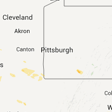
Ohio
| Local Time | Report Details |
|---|---|
| 7:11 PM UTC | Half Dollar sized hail reported near Lancaster, OH, 28.5 miles SE of Columbus, OH, fell briefly. |
| 7:40 PM UTC | Half Dollar sized hail reported near Plain City, OH, 17.5 miles NW of Columbus, OH |
| 7:43 PM UTC | Golf Ball sized hail reported near Plain City, OH, 17.5 miles NW of Columbus, OH |
| 7:46 PM UTC | Golf Ball sized hail reported near Hilliard, OH, 10.3 miles NW of Columbus, OH |
| 8:00 PM UTC | Quarter sized hail reported near Lancaster, OH, 27.2 miles SE of Columbus, OH |
| 8:00 PM UTC | Quarter sized hail reported near Columbus, OH, 3.6 miles W of Columbus, OH, hail three quarter inch to inch. |
| 8:03 PM UTC | Quarter sized hail reported near Columbus, OH, 2.3 miles SSE of Columbus, OH |
| 8:11 PM UTC | Quarter sized hail reported near Columbus, OH, 1.2 miles SW of Columbus, OH, hail occurred near junction of interstate 70 and route 315. |
| 8:24 PM UTC | Quarter sized hail reported near Sugar Grove, OH, 35.6 miles SE of Columbus, OH, near hideaway hills club. |
| 8:45 PM UTC | Ping Pong Ball sized hail reported near Waldo, OH, 34.7 miles N of Columbus, OH |
| 10:32 PM UTC | Quarter sized hail reported near Waldo, OH, 34.7 miles N of Columbus, OH |
| 10:35 PM UTC | Quarter sized hail reported near Tiffin, OH, 80.4 miles N of Columbus, OH |
| 10:44 PM UTC | Quarter sized hail reported near Waldo, OH, 34.7 miles N of Columbus, OH |
| 10:45 PM UTC | One 10 inch diameter tree dow in seneca county OH, 80.4 miles N of Columbus, OH |
| 10:45 PM UTC | One 10 inch tree dow in seneca county OH, 80.4 miles N of Columbus, OH |
| 10:48 PM UTC | Quarter sized hail reported near Attica, OH, 72.3 miles WSW of Cleveland, OH |
| 11:45 PM UTC | Also quarter size hail. observed at intersection of sr37 and cr3 in delaware county OH, 21.5 miles N of Columbus, OH |
| 11:50 PM UTC | Trees and wires down in berlin and genoa township in delaware county OH, 19.3 miles N of Columbus, OH |
| 12:02 AM UTC | Large branches broke in franklin county OH, 11.8 miles NNE of Columbus, OH |
| 12:37 AM UTC | Quarter sized hail reported near Butler, OH, 53.2 miles NE of Columbus, OH |
Georgia
| Local Time | Report Details |
|---|---|
| 7:20 PM UTC | Wsb-tv relayed a viewer report of a downed powerline in a yar in carroll county GA, 39.9 miles WSW of Atlanta, GA |
| 7:22 PM UTC | Haralson county 911 relayed reports of over 4 downed trees and at least a couple of downed powerline in haralson county GA, 39.1 miles W of Atlanta, GA |
| 7:30 PM UTC | Wsb-tv relayed a viewer report of a downed powerline in a yar in carroll county GA, 39.9 miles WSW of Atlanta, GA |
| 7:30 PM UTC | Nws employee reports that 10 trees were downed at the sunset hills country clu in carroll county GA, 43.6 miles WSW of Atlanta, GA |
| 7:30 PM UTC | Quarter sized hail reported near Waynesboro, GA, 19.9 miles SSE of Augusta, GA, quarter size hail at shell bluff country store. |
| 7:47 PM UTC | Douglas county 911 reported a downed tree near the intersection of stewart pkwy and douglas blv in douglas county GA, 22.4 miles W of Atlanta, GA |
| 7:58 PM UTC | Douglas county 911 relayed a report of a downed tree on spring dr in lithia spring in douglas county GA, 15.7 miles W of Atlanta, GA |
| 8:15 PM UTC | Lightning struck a power line and trees are reported down on jimmy lott lan in coffee county GA, 4.5 miles WNW of Douglas, GA |
| 9:48 PM UTC | Valdosta state em/police reported 2 downbursts with winds in excess of 60mph...various trees dow in lowndes county GA, 51.9 miles SSW of Douglas, GA |
| 10:15 PM UTC | 7 trees down across the north parts of the count in twiggs county GA, 90.3 miles SE of Atlanta, GA |
| 10:25 PM UTC | 6 trees down in irwinton are in wilkinson county GA, 83.2 miles WSW of Augusta, GA |
| 10:25 PM UTC | 6 trees down in mcintyre are in wilkinson county GA, 82.7 miles WSW of Augusta, GA |
| 10:46 PM UTC | Multiple trees down in colquitt. house damaged by winds...on grady cobb rd just outside of colquitt. possible large hai in miller county GA, 57 miles NNW of Tallahassee, FL |
| 11:05 PM UTC | Multiple reports of trees and powerlines down across eastern half of count in tift county GA, 39.1 miles W of Douglas, GA |
| 11:15 PM UTC | Multiple trees and powerlines down in alapaha...enigma and nashville. possible large hail in nashvill in berrien county GA, 31.7 miles SW of Douglas, GA |
Florida
| Local Time | Report Details |
|---|---|
| 7:32 PM UTC | Storm damage reported in alachua county FL, 57.9 miles SW of Jacksonville, FL |
| 3:45 PM EDT | St augsutine airport awos repotred wind gust to 61 mp in st. johns county FL, 36.8 miles SE of Jacksonville, FL |
| 3:45 PM EDT | Florida power and light reported trees down on powerlines in st augustin in st. johns county FL, 37.3 miles SSE of Jacksonville, FL |
| 8:40 PM UTC | 12 foot utility trailer was pushed 50 feet across a yard and a 12 foot gazebo collapse in polk county FL, 45.5 miles S of Orlando, FL |
| 8:45 PM UTC | Quarter sized hail reported near St Cloud, FL, 34.5 miles SE of Orlando, FL, spotter reported quarter-sized hail on mercury drive in holopaw. |
| 9:00 PM UTC | Spotter reported multiple large tree limbs down in williamsbur in orange county FL, 9.3 miles SSW of Orlando, FL |
| 9:00 PM UTC | Trees reported down on ottoman road in keystone heights. time is estimated based on rada in bradford county FL, 42.4 miles SW of Jacksonville, FL |
| 9:06 PM UTC | Trees reported down along long bay road in middleburg. time based on radar imager in clay county FL, 20.1 miles SW of Jacksonville, FL |
| 5:20 PM EDT | Trees reported down near the intersection of county road 309 and u.s. highway 17 in satsum in putnam county FL, 53.8 miles S of Jacksonville, FL |
| 10:13 PM UTC | Report of tree broken in half near edison community college in labell in hendry county FL, 47.8 miles NNE of Naples, FL |
| 10:15 PM UTC | Quarter sized hail reported near Moore Haven, FL, 55.5 miles NNE of Naples, FL, large hail reported in muse and ortona. |
| 10:35 PM UTC | Trees and powerlines down across county..but mainly ne portion of count in jackson county FL, 60.3 miles NW of Tallahassee, FL |
| 11:30 PM UTC | Spotter reported estimated winds gusts of 60 mph near intersection of tournament drive and lpga boulevar in volusia county FL, 48.8 miles NNE of Orlando, FL |
| 11:30 PM UTC | Tree down at mm 263 on i-95. estimated 18 inch diameter. time estimated by rada in volusia county FL, 48.6 miles NNE of Orlando, FL |
| 11:35 PM UTC | Spotter reported 30-40 foot tree snapped in half on roadway blocking one lane of traffic on eastbound international speedway at nova roa in volusia county FL, 50 miles NNE of Orlando, FL |
| 12:12 AM UTC | Public reported weather station wind gust of 61 mp in seminole county FL, 10.5 miles N of Orlando, FL |
Maryland
| Local Time | Report Details |
|---|---|
| 8:30 PM UTC | Quarter sized hail reported near Frederick, MD, 44.5 miles WNW of Baltimore, MD, nickel to quarter size hail fell at 1198 avondale court |
| 8:30 PM UTC | Quarter sized hail reported near Frederick, MD, 46 miles WNW of Baltimore, MD, nickel to quarter size hail |
| 11:03 PM UTC | Multiple trees down in the dunkirk area in calvert county MD, 39.5 miles S of Baltimore, MD |
| 11:05 PM UTC | Trees across md-4 at lyons creek rd in calvert county MD, 37.4 miles S of Baltimore, MD |
| 11:05 PM UTC | Trees down in vicinity md-4 and md-260 in anne arundel county MD, 36.7 miles S of Baltimore, MD |
| 11:06 PM UTC | Tree knocked down onto a mobile home near rt 4 and brickhouse road in calvert county MD, 38.8 miles S of Baltimore, MD |
| 11:06 PM UTC | Trees and power lines down near rt 4 and brickhouse road in calvert county MD, 38.1 miles S of Baltimore, MD |
| 11:06 PM UTC | Uprooted and snapped trees and extensive damage to limbs along and near chaneyville road in calvert county MD, 41.5 miles S of Baltimore, MD |
| 11:07 PM UTC | Spotter reported several trees down along rt. 260 from chesapeake beach to dunkirk in calvert county MD, 39.4 miles S of Baltimore, MD |
| 11:12 PM UTC | Multiple trees and powerlines down in chesapeake beach are in calvert county MD, 41.6 miles S of Baltimore, MD |
| 11:15 PM UTC | Large tree down near 3rd street and frederick avenue in calvert county MD, 40.9 miles S of Baltimore, MD |
| 11:15 PM UTC | Trees down along 5th st in calvert county MD, 40.2 miles S of Baltimore, MD |
| 11:15 PM UTC | Several trees down on rt. 261 in anne arundel county MD, 39.6 miles S of Baltimore, MD |
| 11:16 PM UTC | Storm damage reported in anne arundel county MD, 38.9 miles S of Baltimore, MD |
| 11:29 PM UTC | Numerous large trees down on tilghman island in talbot county MD, 42.1 miles SSE of Baltimore, MD |
| 11:29 PM UTC | Trees and wires down..probably s part of tilghman. may issue more detail late in talbot county MD, 42.1 miles SSE of Baltimore, MD |
| 11:39 PM UTC | Trees and wires down...extent unknown. may update late in talbot county MD, 47.7 miles SSE of Baltimore, MD |
| 12:03 AM UTC | Trees down rt. 16 near cabin cree in dorchester county MD, 49.7 miles WNW of Ocean City, MD |
| 12:05 AM UTC | Trees and power lines dow in dorchester county MD, 47.2 miles WNW of Ocean City, MD |
| 12:05 AM UTC | Widespread trees and power lines down throughout tow in dorchester county MD, 47.2 miles WNW of Ocean City, MD |
New Jersey
| Local Time | Report Details |
|---|---|
| 8:45 PM UTC | Quarter sized hail reported near Montclair, NJ, 15.4 miles NW of Brooklyn, NY, quarter size hail in montclair |
| 9:00 PM UTC | Quarter sized hail reported near Montclair, NJ, 15.4 miles NW of Brooklyn, NY, quarter size hail in montclair |
New York
| Local Time | Report Details |
|---|---|
| 8:54 PM UTC | Wires down on routes 150 and 15 in rensselaer county NY, 23.6 miles ESE of Schenectady, NY |
Minnesota
| Local Time | Report Details |
|---|---|
| 10:50 PM UTC | Quarter sized hail reported near Cosmos, MN, 49.9 miles E of Montevideo, MN |
| 1:30 AM UTC | Quarter sized hail reported near Willmar, MN, 36.4 miles E of Montevideo, MN, mostly peas and nickles. |
| 1:35 AM UTC | Quarter sized hail reported near Lake Lillian, MN, 37.2 miles E of Montevideo, MN |
| 1:45 AM UTC | Quarter sized hail reported near Lake Lillian, MN, 39.1 miles E of Montevideo, MN |
| 2:30 AM UTC | Quarter sized hail reported near Madison, MN, 20.4 miles NW of Montevideo, MN |
| 2:35 AM UTC | Quarter sized hail reported near Madison, MN, 20.4 miles NW of Montevideo, MN |
| 5:45 AM UTC | 1 inch tree limbs down in stearns county MN, 64.6 miles NW of Minneapolis, MN |
Kentucky
| Local Time | Report Details |
|---|---|
| 11:03 PM UTC | Tree down on taylors chapel road in green county KY, 46.4 miles S of Louisville, KY |
| 11:12 PM UTC | Tree down in taylor county KY, 48.4 miles SSE of Louisville, KY |
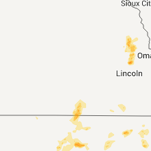
Nebraska
| Local Time | Report Details |
|---|---|
| 12:36 AM UTC | Quarter sized hail reported near Fremont, NE, 32.4 miles WNW of Omaha, NE |
| 12:36 AM UTC | Golf Ball sized hail reported near Cedar Bluffs, NE, 36.1 miles WNW of Omaha, NE |
| 12:47 AM UTC | Golf Ball sized hail reported near Cedar Bluffs, NE, 36.3 miles WNW of Omaha, NE |
| 12:56 AM UTC | Hen Egg sized hail reported near Cedar Bluffs, NE, 36.1 miles WNW of Omaha, NE, hail now a little larger than golf ball size. hail has lasted for at least 10 minutes and was causing significant damage in town. |
| 1:00 AM UTC | Quarter sized hail reported near Fremont, NE, 32.8 miles WNW of Omaha, NE, street flooding also reported in fremont with water to near curb level. |
| 1:00 AM UTC | Quarter sized hail reported near Friend, NE, 57 miles ESE of Grand Island, NE, street flooding also reported in fremont with water to near curb level. |
| 1:12 AM UTC | Ping Pong Ball sized hail reported near Cedar Bluffs, NE, 33.6 miles WNW of Omaha, NE |
| 2:29 AM UTC | Quarter sized hail reported near Wahoo, NE, 35.5 miles W of Omaha, NE |
| 2:31 AM UTC | Golf Ball sized hail reported near Wahoo, NE, 35.5 miles W of Omaha, NE |
| 2:45 AM UTC | Quarter sized hail reported near Wahoo, NE, 35.5 miles W of Omaha, NE, up to quarter size lasted from around 928 until 945 pm. |
Iowa
| Local Time | Report Details |
|---|---|
| 1:35 AM UTC | Quarter sized hail reported near Persia, IA, 29.2 miles NE of Omaha, NE |
New Mexico
| Local Time | Report Details |
|---|---|
| 5:04 AM UTC | Quarter sized hail reported near Moriarty, NM, 3427.1 miles ENE of Caribou, ME |
Connect with Interactive Hail Maps