

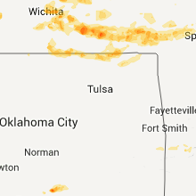
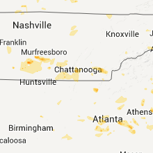
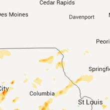
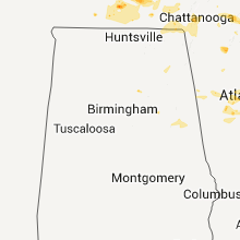
Hail Map for Saturday, June 18, 2011

Number of Impacted Households on 6/18/2011
0
Impacted by 1" or Larger Hail
0
Impacted by 1.75" or Larger Hail
0
Impacted by 2.5" or Larger Hail
Square Miles of Populated Area Impacted on 6/18/2011
0
Impacted by 1" or Larger Hail
0
Impacted by 1.75" or Larger Hail
0
Impacted by 2.5" or Larger Hail


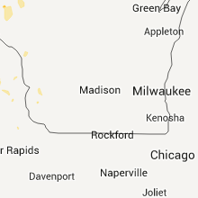


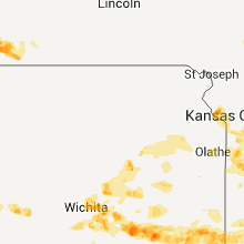


Cities Most Affected by Hail Storms of 6/18/2011
| Hail Size | Demographics of Zip Codes Affected | ||||||
|---|---|---|---|---|---|---|---|
| City | Count | Average | Largest | Pop Density | House Value | Income | Age |
| Platte City, MO | 3 | 2.50 | 3.00 | 128 | $121k | $56.0k | 37.8 |
| Jefferson City, MO | 2 | 2.25 | 2.75 | 308 | $97k | $42.8k | 37.4 |
| Cheyenne Wells, CO | 1 | 4.00 | 4.00 | 0 | $68k | $40.1k | 43.5 |
| Kit Carson, CO | 2 | 1.75 | 1.75 | 0 | $45k | $28.1k | 42.2 |
| Windsor, MO | 2 | 1.75 | 1.75 | 30 | $55k | $31.6k | 39.1 |
| South Haven, KS | 1 | 2.50 | 2.50 | 3 | $38k | $37.0k | 42.5 |
| Maple City, KS | 1 | 2.50 | 2.50 | 56 | $33k | $43.8k | 0.0 |
| Harrisonville, MO | 1 | 2.25 | 2.25 | 122 | $91k | $44.7k | 38.7 |
| Spearville, KS | 1 | 2.00 | 2.00 | 3 | $66k | $40.3k | 41.7 |
| Blue Springs, MO | 1 | 1.75 | 1.75 | 1408 | $117k | $55.8k | 37.3 |
| Chico, TX | 1 | 1.75 | 1.75 | 25 | $63k | $37.7k | 40.4 |
| Cimarron, KS | 1 | 1.75 | 1.75 | 2 | $80k | $40.2k | 34.1 |
| South Portland, ME | 1 | 1.75 | 1.75 | 2065 | $113k | $42.6k | 39.6 |
| Bowling Green, MO | 1 | 1.75 | 1.75 | 38 | $71k | $33.2k | 37.6 |
| Monroe, GA | 1 | 1.75 | 1.75 | 281 | $98k | $36.2k | 35.9 |
| Howard, KS | 1 | 1.75 | 1.75 | 3 | $27k | $28.6k | 50.1 |
| Arkansas City, KS | 1 | 1.75 | 1.75 | 106 | $48k | $31.3k | 36.8 |
| Copan, OK | 1 | 1.75 | 1.75 | 10 | $51k | $30.5k | 46.8 |
| Archie, MO | 1 | 1.75 | 1.75 | 38 | $79k | $39.1k | 36.1 |
| Henrietta, MO | 1 | 1.75 | 1.75 | 10 | $51k | $32.1k | 37.1 |
| Thackerville, OK | 1 | 1.75 | 1.75 | 23 | $50k | $32.2k | 40.7 |
| Enosburg Falls, VT | 1 | 1.75 | 1.75 | 36 | $88k | $36.1k | 39.3 |
| Lake Ozark, MO | 1 | 1.75 | 1.75 | 331 | $154k | $44.3k | 49.4 |
| Springer, OK | 1 | 1.75 | 1.75 | 4 | $42k | $28.8k | 39.2 |
| Benton, KS | 1 | 1.75 | 1.75 | 25 | $82k | $50.1k | 39.7 |
| Pleasant Hill, MO | 1 | 1.75 | 1.75 | 106 | $102k | $52.4k | 38.0 |
| Coffeyville, KS | 1 | 1.75 | 1.75 | 89 | $39k | $28.9k | 39.8 |
Hail and Wind Damage Spotted on 6/18/2011
Filter by Report Type:Hail ReportsWind Reports
States Impacted
Missouri, Illinois, Iowa, Tennessee, Georgia, Vermont, North Carolina, South Carolina, Colorado, Alabama, Florida, Maine, Virginia, Minnesota, New Hampshire, Oklahoma, Kansas, West Virginia, South Dakota, Texas, Wisconsin, North Dakota, Nebraska, Indiana, KentuckyMissouri
| Local Time | Report Details |
|---|---|
| 12:00 PM UTC | Quarter sized hail reported near New Hampton, MO, 83.1 miles NNE of Kansas City, MO |
| 12:28 PM UTC | Power lines dow in harrison county MO, 78.3 miles SSW of Des Moines, IA |
| 4:50 PM UTC | Quarter sized hail reported near Bowling Green, MO, 66.5 miles ENE of Columbia, MO |
| 1:35 AM UTC | Quarter sized hail reported near Eldon, MO, 43.6 miles SSW of Columbia, MO, relayed by krcg tv |
| 1:35 AM UTC | Half Dollar sized hail reported near Calhoun, MO, 67.9 miles SE of Kansas City, MO |
| 1:35 AM UTC | Golf Ball sized hail reported near Lakeview, MO, 53 miles SSW of Columbia, MO |
| 1:53 AM UTC | Golf Ball sized hail reported near Archie, MO, 44.8 miles SSE of Kansas City, MO |
| 2:00 AM UTC | Golf Ball sized hail reported near Windsor, MO, 69.7 miles SE of Kansas City, MO |
| 2:03 AM UTC | Golf Ball sized hail reported near Windsor, MO, 69.7 miles SE of Kansas City, MO |
| 9:07 PM CDT | Baseball sized hail reported near Jefferson City, MO, 29.5 miles SSE of Columbia, MO, deputy sheriff 2 miles south of jefferson city reported golfball size hail |
| 9:20 PM CDT | Half Dollar sized hail reported near Jefferson City, MO, 26.9 miles S of Columbia, MO, one half dollar size hail 2.5 miles west of jefferson city |
| 2:21 AM UTC | Quarter sized hail reported near St Martins, MO, 24.3 miles S of Columbia, MO |
| 2:22 AM UTC | Golf Ball sized hail reported near Jefferson City, MO, 27.5 miles SSE of Columbia, MO, quarter to golfball size hail beginning to cover the ground in westview heights area. |
| 2:25 AM UTC | Quarter sized hail reported near Jefferson City, MO, 27.5 miles SSE of Columbia, MO, northwest side of jefferson city. |
| 2:30 AM UTC | Quarter sized hail reported near Jefferson City, MO, 27.5 miles SSE of Columbia, MO, quarter size hail on west side of jefferson city. |
| 2:33 AM UTC | Half Dollar sized hail reported near Jefferson City, MO, 27.5 miles SSE of Columbia, MO, nickle to one half dollar size hail along western city limits of jefferson city |
| 2:35 AM UTC | Quarter sized hail reported near Creighton, MO, 45.9 miles SSE of Kansas City, MO |
| 2:40 AM UTC | Quarter sized hail reported near Creighton, MO, 49.4 miles SSE of Kansas City, MO |
| 2:42 AM UTC | Quarter sized hail reported near Peculiar, MO, 27.2 miles SSE of Kansas City, MO |
| 9:42 PM CDT | Ping Pong Ball sized hail reported near Harrisonville, MO, 33 miles SSE of Kansas City, MO |
| 9:45 PM CDT | Hen Egg sized hail reported near Harrisonville, MO, 33 miles SSE of Kansas City, MO, photos sent into nws via local media |
| 9:55 PM CDT | Quarter sized hail reported near Harrisonville, MO, 33 miles SSE of Kansas City, MO |
| 3:00 AM UTC | Golf Ball sized hail reported near Pleasant Hill, MO, 30.8 miles SSE of Kansas City, MO |
| 3:16 AM UTC | Ping Pong Ball sized hail reported near Creighton, MO, 45.9 miles SSE of Kansas City, MO |
| 3:30 AM UTC | 5 inch tree branches down in cass county MO, 50 miles SSE of Kansas City, MO |
| 3:31 AM UTC | Quarter sized hail reported near Lone Jack, MO, 28.3 miles SE of Kansas City, MO |
| 3:50 AM UTC | Grain bin destroyed...wind gust estimated at 80 mp in jasper county MO, 53.6 miles ESE of Chanute, KS |
| 11:01 PM CDT | Golf Ball sized hail reported near Blue Springs, MO, 16.3 miles ESE of Kansas City, MO |
| 4:11 AM UTC | Trees down in purcell in jasper county MO, 62.8 miles W of Springfield, MO |
| 4:20 AM UTC | Along with pea sized hail in dade county MO, 38.4 miles WNW of Springfield, MO |
| 4:24 AM UTC | Home weather station measured wind gust of 83 mph in dade county MO, 32.4 miles WNW of Springfield, MO |
| 4:24 AM UTC | Tin roof off of a business in dade county MO, 33.5 miles WNW of Springfield, MO |
| 4:30 AM UTC | Storm damage reported in dade county MO, 33.5 miles WNW of Springfield, MO |
| 4:34 AM UTC | Quarter sized hail reported near Camdenton, MO, 63 miles NNE of Springfield, MO, pea to quarter sized hail reported |
| 4:35 AM UTC | Power lines down in jasper county MO, 54.3 miles ESE of Chanute, KS |
| 4:41 AM UTC | Numerous trees down across central and eastern portions of dade count in dade county MO, 28.2 miles WNW of Springfield, MO |
| 4:45 AM UTC | Ping Pong Ball sized hail reported near Bowling Green, MO, 66.5 miles ENE of Columbia, MO |
| 4:47 AM UTC | Golf Ball sized hail reported near Bowling Green, MO, 66.5 miles ENE of Columbia, MO, deputies reported golf ball size hail in bowling green |
| 4:52 AM UTC | Golf Ball sized hail reported near Henrietta, MO, 35.8 miles ENE of Kansas City, MO |
| 5:00 AM UTC | Barn destroyed...shingles off of a roof...and 6-8 inch tree limbs reported down along greene county farm roads 2 and 6. reported by polk county em in greene county MO, 13.2 miles N of Springfield, MO |
| 5:03 AM UTC | 60 to 70 mph wind gust estimated in greene county MO, 17.6 miles WNW of Springfield, MO |
| 5:07 AM UTC | Storm damage reported in greene county MO, 19.9 miles NW of Springfield, MO |
| 5:12 AM UTC | Storm damage reported in polk county MO, 20.2 miles NNW of Springfield, MO |
| 5:12 AM UTC | Storm damage reported in polk county MO, 27.5 miles NNW of Springfield, MO |
| 5:15 AM UTC | 63 mph gust measured at division and 65. winds also estimated 60-65 mph at 104 mile marker on i-4 in greene county MO, 2.1 miles N of Springfield, MO |
| 5:15 AM UTC | Passed on by greene county oe in greene county MO, 14.1 miles NNE of Springfield, MO |
| 5:15 AM UTC | Damage to roof of kum and go in fair grov in greene county MO, 14.1 miles NNE of Springfield, MO |
| 5:15 AM UTC | Trees and powerlines down along farm road 35 in greene county MO, 11.2 miles NNE of Springfield, MO |
| 5:30 AM UTC | Several limbs dow in polk county MO, 19.5 miles NNW of Springfield, MO |
| 5:35 AM UTC | Tree down and blocking grover road in laclede county MO, 32.8 miles NE of Springfield, MO |
| 5:37 AM UTC | 63 mph gust measured at division and 65. winds also estimated 60-65 mph at 104 mile marker on i-4 in greene county MO, 2.1 miles N of Springfield, MO |
| 5:40 AM UTC | Power lines down across highway w between phillipsburg and lebanon in laclede county MO, 42.7 miles NE of Springfield, MO |
| 5:45 AM UTC | Half Dollar sized hail reported near Rosebud, MO, 52.5 miles N of Salem, MO, hail lasted approximately 8 minutes. |
| 5:45 AM UTC | Trees and power lines down...estimated wind gust to 60 mp in webster county MO, 35.9 miles ENE of Springfield, MO |
| 5:55 AM UTC | Half Dollar sized hail reported near Rosebud, MO, 52.5 miles N of Salem, MO, hail lasted approximately 8 minutes. |
| 5:55 AM UTC | Storm damage reported in laclede county MO, 47.6 miles NE of Springfield, MO |
| 5:55 AM UTC | Tree on a house in eldrige at hwy e and mohave d in laclede county MO, 52.1 miles NE of Springfield, MO |
| 6:02 AM UTC | Golf Ball sized hail reported near Platte City, MO, 18.3 miles NNW of Kansas City, MO |
| 6:04 AM UTC | Quarter sized hail reported near Platte City, MO, 19.5 miles NNW of Kansas City, MO, report via twitter |
| 6:06 AM UTC | Baseball sized hail reported near Platte City, MO, 18.6 miles NNW of Kansas City, MO |
| 6:15 AM UTC | Tea Cup sized hail reported near Platte City, MO, 19.8 miles NNW of Kansas City, MO, all exposed car windshields cracked and/or broken. numerous dings on vehicles from the hail. |
| 6:21 AM UTC | Tree down across highway 17. already cleare in pulaski county MO, 38.8 miles WNW of Salem, MO |
| 6:50 AM UTC | 18 to 30 inch diameter trees downed. time estimate in jefferson county MO, 31 miles SSW of Saint Louis, MO |
| 7:00 AM UTC | Tree down and blocking higway 1 in dent county MO, 0.5 miles SSW of Salem, MO |
| 7:00 AM UTC | Tree down across highway 19 north in dent county MO, 2.4 miles NNE of Salem, MO |
| 7:00 AM UTC | Tree down across highway 68 just north of highway u in dent county MO, 5.1 miles N of Salem, MO |
| 7:05 AM UTC | Spotter reports significant damage to the upper floor of a 2 story house in cherryville. numerous trees and power lines dow in crawford county MO, 20.3 miles NE of Salem, MO |
| 7:05 AM UTC | Uprooted tree in jefferson county MO, 38.9 miles SSW of Saint Louis, MO |
| 7:05 AM UTC | Spotter reports significant damage to the upper floor of a 2 story house west of cherryville. several other homes in the area sustained minor damage. numerous trees and in crawford county MO, 19.1 miles NE of Salem, MO |
| 7:05 AM UTC | Numerous 6 inch limbs broken out of trees. a couple of small trees snapped off near the groun in crawford county MO, 18.4 miles NNE of Salem, MO |
| 7:14 AM UTC | Tree limbs and power lines down near festus. time estimated from rada in jefferson county MO, 30.4 miles SSW of Saint Louis, MO |
| 7:20 AM UTC | Tree limbs and powerlines down. report relayed by fox2. time estimate in jefferson county MO, 27.4 miles SSW of Saint Louis, MO |
| 7:30 AM UTC | Tree limbs and power lines down in jefferson county MO, 27.4 miles SSW of Saint Louis, MO |
| 7:35 AM UTC | Corrugated vinyl roof torn off a chicken coop. chicken coop overturned. several three to four inch diameter tree limbs dow in washington county MO, 47.7 miles SSW of Saint Louis, MO |
| 7:50 AM UTC | Numerous trees uprooted or snapped...12 to 14 inches in diameter and up to 40 feet tall...on the south side of town. time estimate in st. francois county MO, 58.7 miles NW of Cape Girardeau, MO |
| 7:52 AM UTC | Storm damage reported in st. francois county MO, 58.7 miles NW of Cape Girardeau, MO |
| 8:00 AM UTC | Power lines down across the county in ste. genevieve county MO, 46.1 miles S of Saint Louis, MO |
| 8:05 AM UTC | A few trees down on hwy 32 in iron county MO, 49.2 miles E of Salem, MO |
| 8:22 AM UTC | Power outages reported in portions of the communit in perry county MO, 34.5 miles NNW of Cape Girardeau, MO |
Illinois
| Local Time | Report Details |
|---|---|
| 12:18 PM UTC | Very little bit of hai in washington county IL, 51.8 miles ESE of Saint Louis, MO |
| 12:33 PM UTC | Several trees blown down...a few onto power line in fayette county IL, 54.9 miles ENE of Saint Louis, MO |
| 12:38 PM UTC | Trees blown down...a few onto power line in fayette county IL, 45.9 miles WSW of Mattoon, IL |
| 7:00 AM UTC | Two inch diameter tree limbs downed. time estimate in monroe county IL, 29 miles S of Saint Louis, MO |
| 8:45 AM UTC | Measured just west of town by trained spotte in perry county IL, 50.9 miles NNE of Cape Girardeau, MO |
| 9:00 AM UTC | *** 1 inj *** ...update at 430 am...camper blown over with 3 individuals trapped inside located at the du quoin state fairgrounds. individuals had to be extracted by fi in perry county IL, 50.9 miles NNE of Cape Girardeau, MO |
| 9:00 AM UTC | Camper blown over with individuals inside at the du quoin state fairground in perry county IL, 50.9 miles NNE of Cape Girardeau, MO |
| 9:01 AM UTC | Trees dow in franklin county IL, 53.2 miles NE of Cape Girardeau, MO |
| 9:10 AM UTC | Power outages and disruptive phone service reported throughout the communit in franklin county IL, 53.2 miles NE of Cape Girardeau, MO |
| 10:00 AM UTC | 16 inch diameter tree blown down on route 45 at route 50 intersectio in clay county IL, 56.1 miles S of Mattoon, IL |
Iowa
| Local Time | Report Details |
|---|---|
| 12:32 PM UTC | Two large branches down in the north side of town...one crossing the road...time estimated from radar in decatur county IA, 69 miles SSW of Des Moines, IA |
Tennessee
| Local Time | Report Details |
|---|---|
| 3:40 PM UTC | Storm damage reported in weakley county TN, 23.8 miles NW of Mc Kenzie, TN |
| 3:50 PM UTC | Four large trees knocked down across the county in weakley county TN, 7.9 miles NW of Mc Kenzie, TN |
| 4:48 PM UTC | Couple large trees down near hoan creek between yuma and clarksbur in carroll county TN, 21.6 miles SSE of Mc Kenzie, TN |
| 5:00 PM UTC | Storm damage reported in henderson county TN, 34.1 miles SSE of Mc Kenzie, TN |
| 5:00 PM UTC | Roofing damaged on home along independence loo in henderson county TN, 33.4 miles S of Mc Kenzie, TN |
| 5:00 PM UTC | *** 1 inj *** tree fell on home. 1 injury reported at this tim in henderson county TN, 33.7 miles S of Mc Kenzie, TN |
| 5:00 PM UTC | Tree fell on home. 1 injury reported at this tim in henderson county TN, 33.7 miles S of Mc Kenzie, TN |
| 5:05 PM UTC | A couple of trees reported down southwest of camden in benton county TN, 22.7 miles ESE of Mc Kenzie, TN |
| 5:27 PM UTC | Power lines and trees down along and near highway 10 in decatur county TN, 45 miles SSE of Mc Kenzie, TN |
| 5:40 PM UTC | One house destroyed and another with structural damage in southern perry county in perry county TN, 52.5 miles SE of Mc Kenzie, TN |
| 5:57 PM UTC | Numerous trees down along hw in hickman county TN, 45.8 miles SW of Nashville, TN |
| 6:15 PM UTC | Trees in lawrence county TN, 36.4 miles NNE of Florence, AL |
| 1:18 PM CDT | Ping Pong Ball sized hail reported near Shelbyville, TN, 50.2 miles SSE of Nashville, TN |
| 6:23 PM UTC | Power lines down on west 17th street at woodland park in maury county TN, 40.7 miles SSW of Nashville, TN |
| 6:35 PM UTC | Storm damage reported in giles county TN, 45 miles NE of Florence, AL |
| 6:35 PM UTC | Several trees down south of pulaski and large oak trees strippe in giles county TN, 45 miles NE of Florence, AL |
| 6:45 PM UTC | Several trees down near cornersville in marshall county TN, 55.8 miles S of Nashville, TN |
| 6:45 PM UTC | Large branches in roads in coffee county TN, 56.1 miles WNW of Chattanooga, TN |
| 6:50 PM UTC | Minor roof damag in fayette county TN, 26.4 miles ENE of Memphis, TN |
| 6:55 PM UTC | Trees were knocked down onto a home in the capital hill community. time estimated by rada in franklin county TN, 42.5 miles WNW of Chattanooga, TN |
| 6:55 PM UTC | A tree was knocked down on a home in the 4900 block of aedc road. time estimated by rada in franklin county TN, 46 miles WNW of Chattanooga, TN |
| 6:55 PM UTC | Minor roof damag in fayette county TN, 29.1 miles ENE of Memphis, TN |
| 6:58 PM UTC | Several tree down near chapel hill in marshall county TN, 37.3 miles S of Nashville, TN |
| 7:00 PM UTC | A roof was blown off of a barn in the taft area on highway 110/ardmore highway. time and location estimate in lincoln county TN, 56.3 miles ENE of Florence, AL |
| 7:03 PM UTC | A 5 foot diameter tree was knocked down on simmons roa in lincoln county TN, 66 miles ENE of Florence, AL |
| 7:03 PM UTC | A 5 foot diameter tree was knocked down on simmons road. time estimated by rada in lincoln county TN, 66 miles ENE of Florence, AL |
| 7:05 PM UTC | A 5 to 6 foot diameter tree was knocked down on monks road. time estimated by rada in lincoln county TN, 64.2 miles ENE of Florence, AL |
| 7:06 PM UTC | Trees and power lines were knocked down in alto. time estimated by rada in franklin county TN, 39.4 miles WNW of Chattanooga, TN |
| 7:06 PM UTC | Several trees were knocked on highway 23 in lincoln county TN, 65.1 miles ENE of Florence, AL |
| 7:06 PM UTC | Several trees were knocked on highway 231. time estimated by rada in lincoln county TN, 65.1 miles ENE of Florence, AL |
| 7:06 PM UTC | A tree was knocked down on a home in the 400 block of bennett street. time estimated by rada in franklin county TN, 39.7 miles WNW of Chattanooga, TN |
| 7:06 PM UTC | Along prospect road. fences and trailers were damaged. a 3 foot diameter oak tree was knocked dow in lincoln county TN, 66.2 miles ENE of Florence, AL |
| 7:06 PM UTC | Along prospect road. fences and trailers were damaged. a 3 foot diameter oak tree was knocked down. time estimated by rada in lincoln county TN, 66.2 miles ENE of Florence, AL |
| 7:12 PM UTC | Large trees and branches were knocked down on the campus of the university of the south. time estimated by rada in franklin county TN, 36.2 miles WNW of Chattanooga, TN |
| 7:12 PM UTC | A tree was knocked down onto a home in the flintville area on quarters crossroads road. time and location estimate in lincoln county TN, 63 miles W of Chattanooga, TN |
| 7:13 PM UTC | Large trees were knocked down on jump off road and on highway 41 in st. andrews. time estimated by rada in franklin county TN, 34.8 miles WNW of Chattanooga, TN |
| 7:20 PM UTC | Trees and powerlines were knocked down in huntlan in franklin county TN, 54.5 miles W of Chattanooga, TN |
| 7:23 PM UTC | Numerous trees in grundy county TN, 31.6 miles WNW of Chattanooga, TN |
| 7:36 PM UTC | Tree reported down on house along with a tin structure badly damage in lincoln county TN, 67.7 miles ENE of Florence, AL |
| 7:37 PM UTC | Numerous trees down in dunlap. reported by dispatc in sequatchie county TN, 22.8 miles NNW of Chattanooga, TN |
| 8:00 PM UTC | Numerous trees and power lines dow in marion county TN, 22.8 miles W of Chattanooga, TN |
| 8:15 PM UTC | Quarter sized hail reported near Calhoun, TN, 36.2 miles ENE of Chattanooga, TN |
| 8:20 PM UTC | 4 trees dow in polk county TN, 37.6 miles ENE of Chattanooga, TN |
| 8:25 PM UTC | Numerous trees and power lines dow in hamilton county TN, 3.2 miles ENE of Chattanooga, TN |
Georgia
| Local Time | Report Details |
|---|---|
| 3:43 PM UTC | Numerous trees down along jonny mercer blvd and hwy 80... near the wilmington island bridg in chatham county GA, 6.3 miles SE of Savannah, GA |
| 3:44 PM UTC | Broadcast meteorologist reported numerous trees down on bradley point road and johnny mercer blv in chatham county GA, 2.2 miles SSE of Savannah, GA |
| 8:05 PM UTC | At least six trees down across the county...1 tree down across i-59 about 3 miles north of trenton... and numerous trees down across parts of look out moutain east and in dade county GA, 14.3 miles SW of Chattanooga, TN |
| 8:20 PM UTC | Six trees down just north of chickamaug in walker county GA, 10.8 miles S of Chattanooga, TN |
| 8:20 PM UTC | The public reports multiple trees down at this location. other reports from chickamauga are three trees down in the city with one down on a car and dime size hai in walker county GA, 9.4 miles S of Chattanooga, TN |
| 8:30 PM UTC | 3 trees down in the tow in catoosa county GA, 18.6 miles SSE of Chattanooga, TN |
| 8:30 PM UTC | 3 trees down in tow in catoosa county GA, 18.6 miles SSE of Chattanooga, TN |
| 8:40 PM UTC | 4 trees down on 4 different houses within the cit in whitfield county GA, 27.1 miles SE of Chattanooga, TN |
| 8:40 PM UTC | At least 6 trees down around cleveland highway in dalto in whitfield county GA, 27.1 miles SE of Chattanooga, TN |
| 8:40 PM UTC | 2 trees down on houses in rocky fac in whitfield county GA, 23.2 miles SE of Chattanooga, TN |
| 8:40 PM UTC | 3 trees down in the tow in catoosa county GA, 18.6 miles SSE of Chattanooga, TN |
| 9:10 PM UTC | At least 6 trees down with multiple power lines down in epworth are in fannin county GA, 52.6 miles E of Chattanooga, TN |
| 5:15 PM EDT | Numerous trees down across the county to include in the downtown ellijay are in gilmer county GA, 53.1 miles ESE of Chattanooga, TN |
| 9:20 PM UTC | Golf Ball sized hail reported near Monroe, GA, 39.9 miles E of Atlanta, GA |
| 9:21 PM UTC | Pickens county ema relayed a report of widespread tree damage county wide. ema also reports trees down on structures and across some road in pickens county GA, 49.8 miles N of Atlanta, GA |
| 9:31 PM UTC | Dawson county 911 relayed a report of at least 30-50 trees down across the count in dawson county GA, 48.8 miles NNE of Atlanta, GA |
| 9:40 PM UTC | Cherokee county ema relayed a report of widespread tree damage throughout the count in cherokee county GA, 34.4 miles N of Atlanta, GA |
| 9:40 PM UTC | Numerous trees down across the county with several reported in the dallas are in paulding county GA, 28.4 miles WNW of Atlanta, GA |
| 9:58 PM UTC | Trees and lines down across the count in habersham county GA, 54.5 miles WSW of Greenville, SC |
| 10:00 PM UTC | Gwinnett county 911 call center relayed a report of powerlines down in the buford are in gwinnett county GA, 34.1 miles NE of Atlanta, GA |
| 10:00 PM UTC | Damage to billboard and traffic ligh in hall county GA, 36.1 miles NE of Atlanta, GA |
| 10:00 PM UTC | Trees down on house in forsyth county GA, 37.4 miles NNE of Atlanta, GA |
| 10:00 PM UTC | Trees down on house in forsyth county GA, 35.3 miles NNE of Atlanta, GA |
| 10:13 PM UTC | Spotter reports trees and power lines down in the highway 17 are in stephens county GA, 44.5 miles WSW of Greenville, SC |
| 10:15 PM UTC | 2 trees down on 2 cars in marietta. numerous other trees down across the count in cobb county GA, 16.6 miles NNW of Atlanta, GA |
| 10:15 PM UTC | 4 trees down west of monroe. also quarter sized hai in walton county GA, 38.2 miles E of Atlanta, GA |
| 10:15 PM UTC | Quarter sized hail reported near Monroe, GA, 38.2 miles E of Atlanta, GA |
| 10:15 PM UTC | Quarter sized hail reported near Smyrna, GA, 11.7 miles NW of Atlanta, GA |
| 10:23 PM UTC | Quarter sized hail reported near Monroe, GA, 42.1 miles E of Atlanta, GA |
| 10:25 PM UTC | At least 11 trees down in county line are in barrow county GA, 40.5 miles ENE of Atlanta, GA |
| 10:29 PM UTC | Quarter sized hail reported near Smyrna, GA, 11.4 miles NW of Atlanta, GA |
| 10:30 PM UTC | Numerous trees down in all areas of franklin c in franklin county GA, 47.9 miles SW of Greenville, SC |
| 10:40 PM UTC | Trees and power poles snapped off in franklin springs in franklin county GA, 49.2 miles SW of Greenville, SC |
| 10:45 PM UTC | At least 6 trees down from watkinsville to east of bisho in oconee county GA, 57 miles E of Atlanta, GA |
| 10:46 PM UTC | *** 1 fatal *** 1 tree fell on a car and killed 1 person on powers ferry rd in cobb county GA, 16.6 miles NNW of Atlanta, GA |
| 10:50 PM UTC | 4 trees and numerous power lines down in athens. the city of athens is without powe in clarke county GA, 59.9 miles ENE of Atlanta, GA |
| 11:05 PM UTC | A total of 8 trees down in lexington and crawford area in oglethorpe county GA, 70.7 miles WNW of Augusta, GA |
| 11:10 PM UTC | Trees down county wid in elbert county GA, 51.9 miles SSW of Greenville, SC |
| 11:20 PM UTC | Quarter sized hail reported near Lincolnton, GA, 35.8 miles NW of Augusta, GA, camper at elijah clarke state park reports quarter sized hail. |
| 1:00 AM UTC | Report from sherriffs office of a few trees down across county roadways in burke county GA, 26.9 miles S of Augusta, GA |
| 1:34 AM UTC | Multiple reports of numerous trees down along effingham hwy and capitola road. time estimated by rada in screven county GA, 53.9 miles SSE of Augusta, GA |
| 1:52 AM UTC | 911 center reported tree down near intersection of sunbury rd and red mill r in evans county GA, 44 miles W of Savannah, GA |
| 2:10 AM UTC | Dispatch center reported tree down on ga hwy 17n near harry lindsay r in effingham county GA, 30.5 miles NW of Savannah, GA |
| 2:14 AM UTC | 911 center reported tree down on oc banks roa in bulloch county GA, 51.6 miles WNW of Savannah, GA |
| 2:32 AM UTC | Reports of numerous trees down near glennville. time estimated by rada in tattnall county GA, 50.2 miles W of Savannah, GA |
| 2:50 AM UTC | 911 center reported a power line down on rye patch roa in long county GA, 42.7 miles WSW of Savannah, GA |
| 2:54 AM UTC | 911 center reported tree down on palmer roa in long county GA, 42.4 miles WSW of Savannah, GA |
| 2:55 AM UTC | Public reported large tree branch broken over power line in chatham county GA, 7.1 miles NW of Savannah, GA |
| 2:59 AM UTC | Dispatch center reported trees down along ray rd at stable rd and mary todd r in liberty county GA, 39.4 miles WSW of Savannah, GA |
| 3:15 AM UTC | Public report of power lines dow in chatham county GA, 12.7 miles WNW of Savannah, GA |
| 3:34 AM UTC | Spotter reported large tree on road near intersection of chatham parkway and highway 1 in chatham county GA, 5.1 miles WSW of Savannah, GA |
| 3:34 AM UTC | Spotter reported trees down near gould elementar in chatham county GA, 6.2 miles WSW of Savannah, GA |
| 3:43 AM UTC | Media relayed viewer report of a plum tree and pine tree uprooted in yard. small storage shed destroyed by fallen tree in chatham county GA, 5.5 miles ESE of Savannah, GA |
| 3:43 AM UTC | 1 large pine tree down. numerous large branches and power lines dow in chatham county GA, 5.2 miles ESE of Savannah, GA |
| 3:43 AM UTC | Numerous trees down along jonny mercer blvd and hwy 80... near the wilmington island bridg in chatham county GA, 6.3 miles SE of Savannah, GA |
| 3:44 AM UTC | Broadcast meteorologist reported numerous trees down on bradley point road and johnny mercer blv in chatham county GA, 6.4 miles ESE of Savannah, GA |
| 4:03 AM UTC | Public official reported a tree down over power lines on 37th street. time estimated by rada in chatham county GA, 2.2 miles SSE of Savannah, GA |
| 4:03 AM UTC | Public official reported trees down on 54th and waters ave. time estimated by rada in chatham county GA, 2.8 miles S of Savannah, GA |
Vermont
| Local Time | Report Details |
|---|---|
| 5:45 PM UTC | Quarter sized hail reported near Pittsford, VT, 53.7 miles S of Burlington, VT, pittsford country club |
| 5:45 PM UTC | Quarter sized hail reported near Underhill, VT, 13.5 miles ENE of Burlington, VT, located on dean and corbertt roads in underhill |
| 5:50 PM UTC | Half Dollar sized hail reported near Enosburg, VT, 38.7 miles NE of Burlington, VT, driving on route 118 between enosburg falls and montogery center |
| 5:50 PM UTC | Golf Ball sized hail reported near Enosburg, VT, 37.3 miles NE of Burlington, VT |
| 5:52 PM UTC | Quarter sized hail reported near Montgomery, VT, 40.7 miles NE of Burlington, VT |
| 5:55 PM UTC | Ping Pong Ball sized hail reported near Underhill, VT, 18.7 miles E of Burlington, VT, traveling on upper pleasant valley road near underhill state park |
| 6:00 PM UTC | Quarter sized hail reported near Stowe, VT, 25.9 miles E of Burlington, VT, stowe mountain road |
| 6:45 PM UTC | Quarter sized hail reported near Pittsford, VT, 53.7 miles S of Burlington, VT, pittsford country club |
North Carolina
| Local Time | Report Details |
|---|---|
| 5:59 PM UTC | Tree across crawford rd near iron duff rd in haywood county NC, 55.7 miles NNW of Greenville, SC |
| 5:59 PM UTC | Tree across crawford rd in haywood county NC, 55.3 miles NNW of Greenville, SC |
| 6:12 PM UTC | Tree down near flint hill rd and panther branch rd in buncombe county NC, 62.4 miles SSW of Bristol, TN |
| 6:13 PM UTC | Powerlines down and started a fire in buncombe county NC, 54.1 miles N of Greenville, SC |
| 6:15 PM UTC | Tree down piney knob rd and horseback lane in buncombe county NC, 60.3 miles N of Greenville, SC |
| 6:15 PM UTC | Roof off a structure on majestic mountain dr in buncombe county NC, 57.1 miles N of Greenville, SC |
| 6:20 PM UTC | Trees down on beech mtn parkway and on wedling weg rd in beech mt in avery county NC, 32.7 miles SSE of Bristol, TN |
| 6:25 PM UTC | Trees down and roof off house on shope creek road in the riceville are in buncombe county NC, 55.4 miles N of Greenville, SC |
| 6:27 PM UTC | Tree down on bee tree rd in buncombe county NC, 56.2 miles NNE of Greenville, SC |
| 6:27 PM UTC | Tree on vehicle and blocking shady bottom rd in henderson county NC, 38.5 miles N of Greenville, SC |
| 6:35 PM UTC | Trees down all over the count in graham county NC, 44.6 miles S of Knoxville, TN |
| 6:35 PM UTC | A tree fell on a power line on hickory heights driv in ashe county NC, 38.9 miles ESE of Bristol, TN |
| 6:40 PM UTC | Tree on vehicle and blocking shady bottom rd in henderson county NC, 38.5 miles N of Greenville, SC |
| 6:42 PM UTC | One foot thick tree across cimarron rd in henderson county NC, 36.9 miles N of Greenville, SC |
| 6:42 PM UTC | Tree on powerline on greenwood acres drive in henderson county NC, 38.6 miles N of Greenville, SC |
| 6:43 PM UTC | Tree down on west deep for in ashe county NC, 41.3 miles E of Bristol, TN |
| 6:47 PM UTC | One tree down on nc highway 88 and another fell on a power line on east main stree in ashe county NC, 44 miles ESE of Bristol, TN |
| 6:50 PM UTC | Public reported trees blown down in the marion are in mcdowell county NC, 64 miles S of Bristol, TN |
| 6:50 PM UTC | Tree down on naples rd in henderson county NC, 39.6 miles N of Greenville, SC |
| 6:54 PM UTC | Powerlines down on pace rd in henderson county NC, 40 miles NNE of Greenville, SC |
| 6:55 PM UTC | Trees and powerlines down in burke county NC, 56.2 miles SSE of Bristol, TN |
| 6:55 PM UTC | Trees and powerlines down on brown mtn beach rd in burke county NC, 56.2 miles SSE of Bristol, TN |
| 6:55 PM UTC | A tree fell on chestnut hill roa in ashe county NC, 48.4 miles E of Bristol, TN |
| 6:56 PM UTC | A tree was blown down on weaver roa in alleghany county NC, 50.5 miles E of Bristol, TN |
| 6:56 PM UTC | Three trees were blown down on weaver roa in alleghany county NC, 50.5 miles E of Bristol, TN |
| 6:57 PM UTC | Tree down along highway 74 in henderson county NC, 46.4 miles NNE of Greenville, SC |
| 6:58 PM UTC | A tree was blown down at 1700 allen roa in alleghany county NC, 51.6 miles E of Bristol, TN |
| 6:58 PM UTC | A tree was blown down at the 4800 block of route 11 in alleghany county NC, 53.2 miles E of Bristol, TN |
| 6:58 PM UTC | A tree was blown down on route 11 in alleghany county NC, 52.3 miles E of Bristol, TN |
| 7:00 PM UTC | Trees down on powerlines on howard g in polk county NC, 31.6 miles NNE of Greenville, SC |
| 7:00 PM UTC | A tree was blown down at the intersection of route 113 and route 22 in alleghany county NC, 52.9 miles E of Bristol, TN |
| 7:04 PM UTC | Large limbs blown down in the stra in alleghany county NC, 54.4 miles E of Bristol, TN |
| 7:05 PM UTC | Trees down on powerline in burke county NC, 59.7 miles NW of Charlotte, NC |
| 7:07 PM UTC | Tree on a house on hemlock dr ne in caldwell county NC, 60.5 miles SE of Bristol, TN |
| 7:09 PM UTC | A tree was blown down on us route 22 in alleghany county NC, 57 miles E of Bristol, TN |
| 7:10 PM UTC | Storm damage reported in burke county NC, 56.9 miles NW of Charlotte, NC |
| 7:10 PM UTC | Powerlines down on connelly springs rd...caught tree on fir in caldwell county NC, 59.1 miles NW of Charlotte, NC |
| 7:15 PM UTC | Tree down on powerlines on north lake summit road. 911 center reported trees down all areas of count in henderson county NC, 32.6 miles NNE of Greenville, SC |
| 7:15 PM UTC | Damage to a tin bar in alleghany county NC, 62.2 miles E of Bristol, TN |
| 7:15 PM UTC | A tree was blown down on route 2 in alleghany county NC, 61 miles E of Bristol, TN |
| 7:22 PM UTC | Public reported trees blown down in burke county NC, 47.5 miles NW of Charlotte, NC |
| 7:25 PM UTC | Spotter reported multiple trees blown dow in caldwell county NC, 50.4 miles NW of Charlotte, NC |
| 7:34 PM UTC | Spotter reports numerous trees blown down in the lattimore area in cleveland county NC, 47 miles W of Charlotte, NC |
| 7:34 PM UTC | Tree and powerlines down mooresboro and devon rds in cleveland county NC, 49.7 miles W of Charlotte, NC |
| 7:37 PM UTC | Trees and powerlines down across parts of the city in catawba county NC, 45.2 miles NW of Charlotte, NC |
| 7:37 PM UTC | Ham radio operator reported numerous trees blown down on patterson r in cleveland county NC, 44.8 miles W of Charlotte, NC |
| 7:39 PM UTC | Spotter reported a tree down on power lines and large limbs down near south post rd and highway 1 in cleveland county NC, 42 miles W of Charlotte, NC |
| 7:45 PM UTC | Ham radio operator reports trees and power lines blown down at long branch rd and east dixon r in cleveland county NC, 35.8 miles W of Charlotte, NC |
| 7:45 PM UTC | Ham radio operator reports trees and power lines blown down at long branch rd and east dixon rd. one tree is on a house on long branch r in cleveland county NC, 35.8 miles W of Charlotte, NC |
| 7:47 PM UTC | A large limb fell across west atkins street near the elementary schoo in surry county NC, 74.9 miles SW of Roanoke, VA |
| 7:47 PM UTC | A tree fell across dobbins mill roa in surry county NC, 77.1 miles N of Charlotte, NC |
| 7:51 PM UTC | Trees down in catawba county NC, 37.4 miles NNW of Charlotte, NC |
| 7:57 PM UTC | Numerous trees down in and around the city on country club road...fancy gap road...springs road...and on highway 52 just west of town. tree down on house on springs roa in surry county NC, 65.2 miles SW of Roanoke, VA |
| 8:00 PM UTC | Em reports power lines down on highway 90 in iredell county NC, 51 miles N of Charlotte, NC |
| 8:00 PM UTC | A tree fell down on westlake driv in surry county NC, 63.8 miles SW of Roanoke, VA |
| 8:04 PM UTC | Trees down on east pine street in flat rock are in surry county NC, 63 miles SSW of Roanoke, VA |
| 8:05 PM UTC | Large tree limbs down on crowders creek rd near whitworth r in gaston county NC, 21.2 miles W of Charlotte, NC |
| 8:06 PM UTC | Trees down in mecklenburg county NC, 17.8 miles N of Charlotte, NC |
| 8:07 PM UTC | Em reports trees and power lines down on stonemaker r in iredell county NC, 22 miles NNW of Charlotte, NC |
| 8:07 PM UTC | Em reports trees and power lines down on stonemaker r in mecklenburg county NC, 19.2 miles NNW of Charlotte, NC |
| 8:12 PM UTC | Trees down near crowders creek rd and wild wing dr in gaston county NC, 24.2 miles W of Charlotte, NC |
| 8:14 PM UTC | Em reports trees and power lines down at mount ulla hwy and triplett r in iredell county NC, 28.3 miles N of Charlotte, NC |
| 8:23 PM UTC | Powerlines down oak drive in mecklenburg county NC, 6.8 miles N of Charlotte, NC |
| 8:23 PM UTC | Ham radio operator reports power lines down on woodleaf r in rowan county NC, 39.2 miles NNE of Charlotte, NC |
| 8:24 PM UTC | Trees down on east cook st in mecklenburg county NC, 1.8 miles SSE of Charlotte, NC |
| 8:24 PM UTC | Trees down on woodstone dr in mecklenburg county NC, 4.3 miles NNE of Charlotte, NC |
| 8:25 PM UTC | Tree down on swicegood road in davidson county NC, 45.1 miles NE of Charlotte, NC |
| 8:28 PM UTC | Trees down near tyvola rd and old statesville rd in mecklenburg county NC, 4.3 miles SSW of Charlotte, NC |
| 8:30 PM UTC | Tree fell on a house and through the roof at 4000 country club road in western winston-salem in forsyth county NC, 67.3 miles NNE of Charlotte, NC |
| 8:30 PM UTC | Tree down on hendrick mill road at 430 pm in davidson county NC, 52.4 miles NE of Charlotte, NC |
| 8:31 PM UTC | Public reports a large tree down blocking wilann d in mecklenburg county NC, 5 miles E of Charlotte, NC |
| 8:33 PM UTC | Powerlines down near central ave and st. julien st in mecklenburg county NC, 1.6 miles E of Charlotte, NC |
| 8:34 PM UTC | Ham radio operator reported power lines down on highway 2 in rowan county NC, 36.9 miles NNE of Charlotte, NC |
| 8:38 PM UTC | Ham radio operator reported a tree down through a house on 7th street...with power lines also down in the are in rowan county NC, 38.6 miles NNE of Charlotte, NC |
| 8:38 PM UTC | Powerlines down along farmbrook dr in mecklenburg county NC, 4.5 miles SSW of Charlotte, NC |
| 8:39 PM UTC | Trees down along barrington dr in mecklenburg county NC, 5.3 miles ENE of Charlotte, NC |
| 8:40 PM UTC | Large branches broken in cabarrus county NC, 22.2 miles NNE of Charlotte, NC |
| 8:41 PM UTC | Trees down near rocky river and hood roads in mecklenburg county NC, 8.4 miles ENE of Charlotte, NC |
| 8:44 PM UTC | Power lines down along magnolia ave in mecklenburg county NC, 2 miles SW of Charlotte, NC |
| 8:45 PM UTC | Approximately 6-12 trees down across davidson count in davidson county NC, 52 miles NE of Charlotte, NC |
| 8:47 PM UTC | Numeous tress down in stanly county NC, 23.2 miles E of Charlotte, NC |
| 8:49 PM UTC | Several trees down in stanly county NC, 28.6 miles ENE of Charlotte, NC |
| 8:50 PM UTC | Power line damaged by falling limb in forsyth county NC, 73.9 miles NNE of Charlotte, NC |
| 8:50 PM UTC | Tree down on kennedy road at 450 pm in davidson county NC, 60.2 miles NE of Charlotte, NC |
| 8:55 PM UTC | Large branches broken in cabarrus county NC, 25.6 miles ENE of Charlotte, NC |
| 8:56 PM UTC | Large branches broken in forsyth county NC, 75.1 miles NE of Charlotte, NC |
| 8:56 PM UTC | Public reported large tree limbs blown down in the mineral springs are in union county NC, 20.8 miles SSE of Charlotte, NC |
| 9:00 PM UTC | 18 inch diameter limb down in forsyth county NC, 72.8 miles S of Roanoke, VA |
| 9:05 PM UTC | Several trees dow in cherokee county NC, 57.6 miles SSW of Knoxville, TN |
| 9:08 PM UTC | 12 inch diameter tree snapped in half in guilford county NC, 74 miles WNW of Raleigh, NC |
| 9:10 PM UTC | Several trees down in the ranger are in cherokee county NC, 63.2 miles S of Knoxville, TN |
| 9:15 PM UTC | Large branches broken in davidson county NC, 47 miles NE of Charlotte, NC |
| 9:20 PM UTC | Widespread tree and power line damage across the count in union county NC, 23.3 miles SE of Charlotte, NC |
| 9:25 PM UTC | Tree down on ansonville-polkton road in anson county NC, 41.5 miles ESE of Charlotte, NC |
| 9:25 PM UTC | Numerous trees down in randolph county in randolph county NC, 65.8 miles W of Raleigh, NC |
| 9:25 PM UTC | Tree down on mt vernon road in anson county NC, 41.5 miles ESE of Charlotte, NC |
| 9:25 PM UTC | Tree down in randolph county NC, 65.2 miles ENE of Charlotte, NC |
| 9:25 PM UTC | Tree down in randolph county NC, 64.7 miles ENE of Charlotte, NC |
| 9:25 PM UTC | Tree down in randolph county NC, 65.8 miles ENE of Charlotte, NC |
| 9:30 PM UTC | Several trees dow in clay county NC, 63 miles S of Knoxville, TN |
| 9:30 PM UTC | 1 foot diameter tree blown over... 52 mph wind measured by anemometer in guilford county NC, 57 miles WNW of Raleigh, NC |
| 9:35 PM UTC | *** 1 fatal *** tree limb snapped and killed a 39 year old woman on blewett falls road in lilesville. the strong winds associated with the storm were out in advance of in anson county NC, 54.3 miles ESE of Charlotte, NC |
| 9:35 PM UTC | Six inch diameter tree down in guilford county NC, 52.2 miles WNW of Raleigh, NC |
| 9:45 PM UTC | Power lines blown down in alamance county NC, 49.7 miles WNW of Raleigh, NC |
| 9:50 PM UTC | Tree down on durham st extension in alamance county NC, 51.8 miles WNW of Raleigh, NC |
| 9:50 PM UTC | Tree down on spanish oak road in alamance county NC, 48.5 miles WNW of Raleigh, NC |
| 9:53 PM UTC | Tree down in richmond county NC, 66 miles ESE of Charlotte, NC |
| 9:53 PM UTC | Tree down on pirate lane in richmond county NC, 66 miles ESE of Charlotte, NC |
| 9:58 PM UTC | Tree down near hamlet in richmond county NC, 67.1 miles ESE of Charlotte, NC |
| 10:04 PM UTC | Trees down near west end in moore county NC, 64.9 miles SW of Raleigh, NC |
| 10:05 PM UTC | Tree down on white cross road in orange county NC, 31 miles WNW of Raleigh, NC |
| 10:10 PM UTC | 10 large trees down along furr road... 1 tree measured at 1 foot in diameter in moore county NC, 54.3 miles SW of Raleigh, NC |
| 10:13 PM UTC | 4 inch diameter tree down... 3 inch diamter limb down in lee county NC, 40.3 miles SW of Raleigh, NC |
| 10:13 PM UTC | Tree down in orange county NC, 32.4 miles NW of Raleigh, NC |
| 10:15 PM UTC | Tree down on shed in orange county NC, 42.5 miles NW of Raleigh, NC |
| 10:20 PM UTC | Trees down across county in scotland county NC, 83.6 miles ESE of Charlotte, NC |
| 10:20 PM UTC | Approximately 6 trees down in lee county in lee county NC, 36.9 miles SW of Raleigh, NC |
| 10:21 PM UTC | Trees down in orange county NC, 24.4 miles WNW of Raleigh, NC |
| 10:25 PM UTC | Tree down on fulford mcmillan road in hoke county NC, 68 miles SW of Raleigh, NC |
| 10:32 PM UTC | 8 inch diameter tree down in lee county NC, 37.4 miles WSW of Raleigh, NC |
| 10:33 PM UTC | Storm damage reported in cumberland county NC, 47.4 miles SSW of Raleigh, NC |
| 10:38 PM UTC | Tree down on house in durham county NC, 15.8 miles WNW of Raleigh, NC |
| 10:40 PM UTC | Reported trees down near intersection of union chapel rd and barber shop rd. time of event estimated by rada in robeson county NC, 75.4 miles WNW of Wilmington, NC |
| 10:43 PM UTC | Tree down near fayetteville in cumberland county NC, 51.4 miles SSW of Raleigh, NC |
| 10:45 PM UTC | Tree down at 645 pm in durham county NC, 17.1 miles NW of Raleigh, NC |
| 10:45 PM UTC | Three trees down across bridgers rd near purvis rd. time of event estimated by rada in robeson county NC, 77.7 miles WNW of Wilmington, NC |
| 10:45 PM UTC | Reported tree down on north chicken rd near hwy 211 west. time of event estimated by rada in robeson county NC, 72.5 miles WNW of Wilmington, NC |
| 10:48 PM UTC | Tree down in durham county NC, 16.9 miles WNW of Raleigh, NC |
| 10:50 PM UTC | Powerlines down across roadway on dobbs drive. time of event estimated by rada in robeson county NC, 64.1 miles SSW of Raleigh, NC |
| 11:15 PM UTC | Roof blown off mobile home on singletary church r in robeson county NC, 58.9 miles WNW of Wilmington, NC |
| 11:15 PM UTC | Roof blown off mobile home on singletary church rd. time of event estimated by rada in robeson county NC, 58.9 miles WNW of Wilmington, NC |
| 11:20 PM UTC | Tree down across john mitchel road at 720 pm and a few other tress down nearby on nc 96 in franklin county NC, 18.8 miles NNE of Raleigh, NC |
| 11:30 PM UTC | 10 to 15 trees down between clinton and garland in sampson county NC, 57 miles SSE of Raleigh, NC |
| 11:54 PM UTC | Several large trees blown down on mote road near white lake. report relayed through local tv meteorologis in bladen county NC, 41.5 miles NW of Wilmington, NC |
| 12:12 AM UTC | Trees down along with power lines and transformer on nash johnson pond r in duplin county NC, 46.3 miles N of Wilmington, NC |
| 12:31 AM UTC | Trees down on frank cottle rd in duplin county NC, 41.3 miles N of Wilmington, NC |
| 12:51 AM UTC | Trees down along with powerlines and transformer on e. southerland st in duplin county NC, 34.3 miles N of Wilmington, NC |
| 12:51 AM UTC | Trees down along with powerlines and transformer on frank cottle rd in duplin county NC, 34.3 miles N of Wilmington, NC |
| 9:25 AM UTC | Tree down on garage in walnut communit in madison county NC, 59.1 miles SSW of Bristol, TN |
| 11:20 AM UTC | Trees down along hwy 25/70 north of marshal in madison county NC, 58.8 miles SSW of Bristol, TN |
| 11:55 AM UTC | Power lines down along oneil circl in buncombe county NC, 54.1 miles NNE of Greenville, SC |
South Carolina
| Local Time | Report Details |
|---|---|
| 6:30 PM UTC | Trees down on powerlines on dr. johns r in oconee county SC, 30 miles WSW of Greenville, SC |
| 7:13 PM UTC | Tree in roadway near us 178 and rocky bottom rd in pickens county SC, 18.9 miles NW of Greenville, SC |
| 7:17 PM UTC | Powerlines down on red hill lane in spartanburg county SC, 33.3 miles NE of Greenville, SC |
| 7:20 PM UTC | Tree in roadway cooley springs rd and mcswain rd in spartanburg county SC, 43.1 miles NE of Greenville, SC |
| 7:22 PM UTC | Ham radio operator reported power lines down at cannon ford rd and country estates rd. also highway patrol reports a tree down on coley spring rd- 3 ne in spartanburg county SC, 39.3 miles ENE of Greenville, SC |
| 7:35 PM UTC | Tree in roadway highway 9 and business 85 in spartanburg county SC, 38.7 miles ENE of Greenville, SC |
| 7:44 PM UTC | Ham radio operator reports a tree down on a house on fulton ave...with fire dept dispatched to extract occupants in spartanburg county SC, 38.5 miles ENE of Greenville, SC |
| 7:45 PM UTC | Ham radio operator reports trees down on north st and duncan s in spartanburg county SC, 38.8 miles ENE of Greenville, SC |
| 7:45 PM UTC | Tree in roadway near east cherokee st in cherokee county SC, 36.2 miles W of Charlotte, NC |
| 7:45 PM UTC | Tree down near i-85 mm104 in cherokee county SC, 36.6 miles W of Charlotte, NC |
| 7:45 PM UTC | 8-10 inch diameter tree snapped off lindsey ridge rd in spartanburg county SC, 25.7 miles ENE of Greenville, SC |
| 7:47 PM UTC | Ham radio operator reported trees down at highway 29 and highway 10 in cherokee county SC, 47.7 miles WSW of Charlotte, NC |
| 8:02 PM UTC | Spotter reports large limbs down on phone lines on forest s in union county SC, 52.3 miles E of Greenville, SC |
| 8:15 PM UTC | Trees and limbs down on burns bridge rd and greate rd off hw in anderson county SC, 17.7 miles SSW of Greenville, SC |
| 8:15 PM UTC | Half Dollar sized hail reported near Anderson, SC, 21.9 miles SW of Greenville, SC, ice cube size hail on coneross creek rd- between quarter and golf ball size. |
| 8:15 PM UTC | Half Dollar sized hail reported near Seneca, SC, 21.7 miles SW of Greenville, SC, on coneross cre |
| 8:15 PM UTC | Half Dollar sized hail reported near Townville, SC, 24.3 miles SW of Greenville, SC, person stated hail was the size of ice |
| 8:21 PM UTC | Tree in roadway near ora rd and us 221 in laurens county SC, 38.2 miles ESE of Greenville, SC |
| 8:30 PM UTC | Ham radio operator reported power lines down on dawson dr. other power lines are down in the western part of the count in chester county SC, 41.2 miles SSW of Charlotte, NC |
| 8:38 PM UTC | Highway patrol reports a tree down on highway 308 just north of the city...with another tree on young rd 3 se of tow in laurens county SC, 47.8 miles ESE of Greenville, SC |
| 8:38 PM UTC | Tree in roadway along hw-308 in laurens county SC, 46.4 miles ESE of Greenville, SC |
| 8:44 PM UTC | Tree in road...simpson rd and harmony church r in chester county SC, 32.1 miles SSW of Charlotte, NC |
| 8:45 PM UTC | County sherriff reports numerous trees and powerlines down between hwy 5 south to the city of lancaster in lancaster county SC, 34.8 miles S of Charlotte, NC |
| 8:50 PM UTC | Media reported several trees and large limbs down on york s in laurens county SC, 48.1 miles ESE of Greenville, SC |
| 8:53 PM UTC | Tree in roadway near young rd and us 7 in laurens county SC, 50.7 miles ESE of Greenville, SC |
| 8:55 PM UTC | Awos at lancaster county mcwhirter field airport observed a wind gust of 50 knots..or 58 mp in lancaster county SC, 34 miles S of Charlotte, NC |
| 9:15 PM UTC | Sherriffs dispatch reports numerous trees down countywide including the city of newberr in newberry county SC, 59.1 miles NNE of Augusta, GA |
| 9:18 PM UTC | Tree in roadway along sam hodges and morgan rds in greenwood county SC, 39 miles SSE of Greenville, SC |
| 9:21 PM UTC | Sc hwy patrol reports tree in roadway near sc hwy 56 and brehmer roa in newberry county SC, 55 miles N of Augusta, GA |
| 9:30 PM UTC | Tree in roadway along us 25 in greenwood county SC, 44.9 miles SSE of Greenville, SC |
| 9:58 PM UTC | Sherriff office reports trees down on brocks mill road. time estimated by rada in chesterfield county SC, 57.2 miles ESE of Charlotte, NC |
| 10:16 PM UTC | Tree down near intersection of s fifth street and patrick hw in darlington county SC, 71.9 miles SE of Charlotte, NC |
| 10:16 PM UTC | Tree down near intersection of s fifth street and patrick hwy. time of event estimated by rada in darlington county SC, 71.9 miles SE of Charlotte, NC |
| 10:16 PM UTC | Tree down on east old camden rd near sister sister. event time estimated by rada in darlington county SC, 68.5 miles SE of Charlotte, NC |
| 10:16 PM UTC | Reported tree down on bethlehem rd between us hwy 15 and byrdtown rd. time of event estimated by rada in darlington county SC, 72.2 miles SE of Charlotte, NC |
| 10:17 PM UTC | Reported tree down on new hopewell r in darlington county SC, 73.3 miles SE of Charlotte, NC |
| 10:17 PM UTC | Reported tree down on new hopewell rd. time of event estimated by rada in darlington county SC, 73.3 miles SE of Charlotte, NC |
| 10:17 PM UTC | Tree down on east old camden rd near sister siste in darlington county SC, 68.5 miles SE of Charlotte, NC |
| 10:18 PM UTC | Report of tree down on sc 9. time of event estimated by rada in marlboro county SC, 83.7 miles ESE of Charlotte, NC |
| 10:19 PM UTC | Kbbp asos reported gust of 58 mp in marlboro county SC, 76.9 miles ESE of Charlotte, NC |
| 10:20 PM UTC | Several trees down along hwy 702 east of ninety si in greenwood county SC, 47.7 miles N of Augusta, GA |
| 10:20 PM UTC | Sc hwy patrol reports tree in road near intersection of seagull lane and osprey point at lake murray in newberry county SC, 49.3 miles NNE of Augusta, GA |
| 10:24 PM UTC | Trees down near morningside drive and beatty rd in west columbi in lexington county SC, 63 miles NE of Augusta, GA |
| 10:25 PM UTC | Em reported trees down in cheraw on laney and old cash road in chesterfield county SC, 64.2 miles SE of Charlotte, NC |
| 10:26 PM UTC | Trees down near us highway 76 and hiller r in richland county SC, 59.9 miles NE of Augusta, GA |
| 10:30 PM UTC | Couple trees down along hwy 67 near calliso in greenwood county SC, 37.7 miles NNW of Augusta, GA |
| 10:45 PM UTC | Powerlines in road...hw-187 and fisher jenkins r in anderson county SC, 19.2 miles SW of Greenville, SC |
| 10:53 PM UTC | Tree in roadway...near i-85 mm 11 in anderson county SC, 24.8 miles SSW of Greenville, SC |
| 11:15 PM UTC | Tree in roadway near us 76 and brick mill rd in anderson county SC, 26.9 miles SSE of Greenville, SC |
| 11:20 PM UTC | Report of tree down on lanneiu snipes rd near sc 41. time of event estimated by rada in marion county SC, 71.6 miles NNE of Charleston, SC |
| 12:15 AM UTC | Sc hwy patrol reports trees down on interstate 20 between mile markers 2 and in aiken county SC, 4.3 miles NNW of Augusta, GA |
| 12:40 AM UTC | Trees down at the intersection of powderhouse rd and vanderbilt dr southeast of aike in aiken county SC, 16 miles E of Augusta, GA |
| 1:08 AM UTC | Numerous reports of trees down along yemassee hwy and walterboro hwy. time estimated by rada in hampton county SC, 53 miles N of Savannah, GA |
| 1:21 AM UTC | Trees and powerlines down in various locations in allendale count in allendale county SC, 50.3 miles SE of Augusta, GA |
| 1:23 AM UTC | Trees down on low country highway...reported by sch in bamberg county SC, 49.9 miles ESE of Augusta, GA |
| 1:42 AM UTC | Numerous reports of trees down along yemassee hwy and walterboro hwy. time estimated by rada in hampton county SC, 53 miles N of Savannah, GA |
| 2:00 AM UTC | County officials relayed numerous reports of trees down. time estimated by rada in jasper county SC, 40.8 miles N of Savannah, GA |
| 2:00 AM UTC | County officials relayed numerous reports of trees down across the northern portion of the county. time estimated by rada in colleton county SC, 44.7 miles WSW of Charleston, SC |
| 2:01 AM UTC | Dispatch center reported trees down at la creuset rd and river r in beaufort county SC, 44.7 miles NNE of Savannah, GA |
| 2:01 AM UTC | Dispatch center reported trees down near old sheldon church and castle hall r in beaufort county SC, 43.8 miles NNE of Savannah, GA |
| 2:07 AM UTC | County officials relayed numerous reports of trees and power lines down. time estimated by rada in colleton county SC, 43 miles WSW of Charleston, SC |
| 2:09 AM UTC | Dispatch center reported trees down near big estate rd and river r in beaufort county SC, 44.6 miles NNE of Savannah, GA |
| 2:10 AM UTC | Dispatch center reported trees down on bailey r in beaufort county SC, 40.5 miles NNE of Savannah, GA |
| 2:14 AM UTC | Dispatch center reported trees down near jenkins and green circl in beaufort county SC, 42.7 miles NNE of Savannah, GA |
| 2:41 AM UTC | Dispatch center reported trees down on colony gardens r in beaufort county SC, 35.8 miles NE of Savannah, GA |
| 2:59 AM UTC | Nws employee reported large tree down along bees ferry r in charleston county SC, 26.3 miles S of Charleston, SC |
| 3:00 AM UTC | Large oak tree down near the intersection of main road and river roa in charleston county SC, 29.3 miles S of Charleston, SC |
| 9:51 AM UTC | Tree down on hilltop dr near high s in chester county SC, 41.2 miles SSW of Charlotte, NC |
Colorado
| Local Time | Report Details |
|---|---|
| 6:55 PM UTC | Quarter sized hail reported near Ramah, CO, 53.8 miles SE of Denver, CO |
| 8:10 PM UTC | Quarter sized hail reported near Agate, CO, 58.6 miles ESE of Denver, CO |
| 8:15 PM UTC | Ping Pong Ball sized hail reported near Limon, CO, 76.8 miles ESE of Denver, CO |
| 8:16 PM UTC | Ping Pong Ball sized hail reported near Limon, CO, 76.8 miles ESE of Denver, CO |
| 8:20 PM UTC | Half Dollar sized hail reported near Otis, CO, 18 miles W of Yuma, CO |
| 8:29 PM UTC | Ping Pong Ball sized hail reported near Otis, CO, 12.7 miles W of Yuma, CO |
| 9:09 PM UTC | Quarter sized hail reported near Vona, CO, 38.7 miles S of Yuma, CO |
| 9:40 PM UTC | Golf Ball sized hail reported near Kit Carson, CO, 80.3 miles SSW of Yuma, CO |
| 9:50 PM UTC | 5 and 9 inch limbs torn from trees. 10 ft. long empty stock tank blown 1/8 mile. 10 ft. long metal feeder damaged and blown 1/16 mile. estimated time of report from rad in cheyenne county CO, 84.7 miles S of Yuma, CO |
| 10:10 PM UTC | Golf Ball sized hail reported near Kit Carson, CO, 79.9 miles S of Yuma, CO |
| 10:12 PM UTC | Half Dollar sized hail reported near Kit Carson, CO, 84.2 miles S of Yuma, CO |
| 10:13 PM UTC | Quarter sized hail reported near Kit Carson, CO, 85.4 miles S of Yuma, CO |
| 10:17 PM UTC | Ping Pong Ball sized hail reported near Kit Carson, CO, 85.4 miles S of Yuma, CO |
| 10:30 PM UTC | 5 to 6 inch diameter tree limbs down around town. time approximat in cheyenne county CO, 93.8 miles S of Yuma, CO |
| 11:05 PM UTC | Grapefruit sized hail reported near Cheyenne Wells, CO, 82.8 miles WSW of Colby, KS |
| 11:22 PM UTC | Dime to quarter size hail falling also in cheyenne county CO, 85.1 miles SW of Colby, KS |
| 11:34 PM UTC | Power pole snapped off at base in cheyenne county CO, 100 miles S of Yuma, CO |
Alabama
| Local Time | Report Details |
|---|---|
| 7:05 PM UTC | Roof damage sunstained to a shed in madison county AL, 52.8 miles E of Florence, AL |
| 7:05 PM UTC | Roof damage sustained to a shed in madison county AL, 52.8 miles E of Florence, AL |
| 7:16 PM UTC | Several trees were blown down in and around ardmore...especially on main stree in limestone county AL, 48.7 miles ENE of Florence, AL |
| 7:16 PM UTC | Several trees were blown down in and around ar in limestone county AL, 48.7 miles ENE of Florence, AL |
| 7:20 PM UTC | A bradford pear tree was knocked down on cummings research par in madison county AL, 56.8 miles E of Florence, AL |
| 7:20 PM UTC | A bradford pear tree was knocked down on cummings research park. time estimated by rada in madison county AL, 56.8 miles E of Florence, AL |
| 7:23 PM UTC | Trees were blown down blocking roadways on bell factory and streakley road in madison county AL, 67.7 miles WSW of Chattanooga, TN |
| 7:23 PM UTC | Tree blown down on hurricane creek road in madison county AL, 66.4 miles WSW of Chattanooga, TN |
| 7:25 PM UTC | Several trees down along winchester roa in madison county AL, 64.3 miles W of Chattanooga, TN |
| 7:25 PM UTC | Multiple tree branches blown down. some one inch in diamete in madison county AL, 68.1 miles WSW of Chattanooga, TN |
| 7:25 PM UTC | Tree reported down along greenville pike road in northern madison count in madison county AL, 67.7 miles W of Chattanooga, TN |
| 7:25 PM UTC | A tree was blown down on brownsboro roa in madison county AL, 66.4 miles WSW of Chattanooga, TN |
| 7:30 PM UTC | Two trees were snapped. a six inch diameter tree was snapped at its base while a sapling with a one inch diameter trunk was snapped halfway up the tre in jackson county AL, 56 miles WSW of Chattanooga, TN |
| 7:30 PM UTC | A 100 foot tall pine tree was uprooted and knocked down onto a home on bremerton drive southwes in madison county AL, 54.9 miles ESE of Florence, AL |
| 7:30 PM UTC | A tree six feet in diameter was blown down onto a roo in madison county AL, 54.9 miles ESE of Florence, AL |
| 7:30 PM UTC | Branches were blown off a tree onto a roo in madison county AL, 54.9 miles ESE of Florence, AL |
| 7:40 PM UTC | Several reports of trees and powerlines knocked down in the skyline area. power is out. time estimated by rada in jackson county AL, 48.8 miles WSW of Chattanooga, TN |
| 7:48 PM UTC | Damaged sustained to a funeral tent...literally blown ove in madison county AL, 52.8 miles E of Florence, AL |
| 7:52 PM UTC | A tree was knocked down onto a home on county road 20 in jackson county AL, 25.3 miles WSW of Chattanooga, TN |
| 7:53 PM UTC | Numerous trees and powerlines were knocked down in the city of bridgeport and surrounding areas. power is out. a tree was knocked onto a home on dr. lee avenue in bridg in jackson county AL, 24.4 miles WSW of Chattanooga, TN |
| 8:00 PM UTC | Power lines reported down from childress to jackson road in madison county AL, 64.8 miles WSW of Chattanooga, TN |
| 8:00 PM UTC | Trees reported down from gurley to the east side of the count in madison county AL, 64.3 miles W of Chattanooga, TN |
| 8:12 PM UTC | Tree down on powerline on chalakee roa in marshall county AL, 64.3 miles NNE of Birmingham, AL |
| 8:40 PM UTC | A tree was blown down near hustleville road and baker roa in marshall county AL, 68 miles NNE of Birmingham, AL |
| 8:54 PM UTC | Power lines and trees were blown dow in dekalb county AL, 40.8 miles SSW of Chattanooga, TN |
| 8:55 PM UTC | Power lines down on county road 46 near county road 15 near the broomtown fire department. tree down on county road 6 in cherokee county AL, 49.5 miles SSW of Chattanooga, TN |
Florida
| Local Time | Report Details |
|---|---|
| 8:05 PM UTC | Ktix awos measured a 50 kt/58 mph wind gus in brevard county FL, 34.1 miles E of Orlando, FL |
| 4:25 PM EDT | Trees reported down across powerlines along county road 309 near satsum in putnam county FL, 55.9 miles S of Jacksonville, FL |
| 5:15 PM EDT | 6 inch diameter tree limb down in yard on nova rd. between cedar st. and south st. time estimated from rada in volusia county FL, 50.8 miles NNE of Orlando, FL |
| 9:15 PM UTC | 2 foot diameter tree toppled onto sidewalk near nova rd. and beville rd. time estimated from rada in volusia county FL, 49 miles NNE of Orlando, FL |
| 5:37 PM EDT | Emergency management relayed report from dept of forestry of kmart sign damaged and parts on road at us 92 and west international speedway blv in volusia county FL, 47.1 miles NNE of Orlando, FL |
| 6:53 PM EDT | Quarter sized hail reported near Oviedo, FL, 14.1 miles NE of Orlando, FL, quarter size hail along with estimated 50 knot wind gusts and small tree branches in street observed near intersection of east mitchell hammock and kingsbridge drive in |
| 6:58 PM EDT | Quarter sized hail reported near Oviedo, FL, 12 miles ENE of Orlando, FL, quarter inch hail observed near intersection of alafaya trail and chapman rd. |
| 7:11 PM EDT | Kmco orlando international airport asos measured a 61 kt/70 mph wind gus in orange county FL, 2.7 miles S of Orlando, FL |
| 7:20 PM EDT | Quarter sized hail reported near Orlando, FL, 6.7 miles SE of Orlando, FL, quarter size hail along with estimated 60 mph wind gust and minor street flooding near intersection of hoffner ave. and goldenrod rd. in orlando. |
| 11:30 PM UTC | Wftv channel 9 reported large tree fell onto part of roof of house near intersection of simms ave. and merryweather dr. in orland in orange county FL, 5.8 miles SSE of Orlando, FL |
| 12:00 AM UTC | Ksc 54 foot tower number 2202 measured 56 kt/64 mph wind gus in orange county FL, 22.8 miles ESE of Orlando, FL |
| 12:36 AM UTC | Kcof patrick afb measured 56 kt/64 mph wind gus in brevard county FL, 51 miles ESE of Orlando, FL |
| 12:48 AM UTC | Kcof patrick afb measured 53 kt/61 mph wind gus in brevard county FL, 51 miles ESE of Orlando, FL |
| 12:50 AM UTC | Kcof patrick afb measured 50 kt/58 mph wind gus in brevard county FL, 51 miles ESE of Orlando, FL |
Maine
| Local Time | Report Details |
|---|---|
| 8:10 PM UTC | Trees down in somerset county ME, 55 miles W of Bangor, ME |
| 8:25 PM UTC | Quarter sized hail reported near Smithfield, ME, 51.1 miles WSW of Bangor, ME, ground covered rt 137 near town line |
| 8:25 PM UTC | Quarter sized hail reported near Norridgewock, ME, 53.8 miles W of Bangor, ME, ground covered rt 137 near town line |
| 8:35 PM UTC | Trees down in somerset county ME, 53 miles WSW of Bangor, ME |
| 9:14 PM UTC | Half Dollar sized hail reported near Sidney, ME, 52.2 miles WSW of Bangor, ME |
| 9:16 PM UTC | Storm damage reported in oxford county ME, 40.8 miles NNW of Portland, ME |
| 9:34 PM UTC | Quarter sized hail reported near Oxford, ME, 35.5 miles NNW of Portland, ME |
| 9:41 PM UTC | Quarter sized hail reported near Gorham, ME, 9.3 miles W of Portland, ME |
| 9:45 PM UTC | Quarter sized hail reported near Readfield, ME, 52.4 miles NNE of Portland, ME |
| 9:46 PM UTC | Large limbs down in androscoggin county ME, 28.5 miles NNW of Portland, ME |
| 9:48 PM UTC | Quarter sized hail reported near Auburn, ME, 30.5 miles N of Portland, ME |
| 9:50 PM UTC | Quarter sized hail reported near Windsor, ME, 52.4 miles SW of Bangor, ME |
| 9:50 PM UTC | Golf Ball sized hail reported near South Portland, ME, 1.6 miles SSE of Portland, ME, golf ball size hail |
| 9:53 PM UTC | Quarter sized hail reported near Hallowell, ME, 49.4 miles NNE of Portland, ME |
| 9:55 PM UTC | Half Dollar sized hail reported near Augusta, ME, 50.8 miles NNE of Portland, ME, half dollar size hail |
| 9:55 PM UTC | Quarter sized hail reported near Scarborough, ME, 6.3 miles SSW of Portland, ME, on the scarborough south portland town line. |
| 9:59 PM UTC | Quarter sized hail reported near Hallowell, ME, 49.4 miles NNE of Portland, ME |
| 10:00 PM UTC | Quarter sized hail reported near South Portland, ME, 1.6 miles SSE of Portland, ME |
| 10:01 PM UTC | Quarter sized hail reported near Cape Elizabeth, ME, 2.7 miles S of Portland, ME |
| 10:10 PM UTC | Trees down on wires in durham in androscoggin county ME, 22.5 miles NNE of Portland, ME |
Virginia
| Local Time | Report Details |
|---|---|
| 8:35 PM UTC | Numerous reports of trees down across the county. some locations include meadows o in patrick county VA, 48.1 miles SSW of Roanoke, VA |
| 9:00 PM UTC | Tree down on philpott drive in franklin county VA, 31.4 miles S of Roanoke, VA |
| 9:12 PM UTC | A few small trees down near highlane ave s in city of roanoke county VA, 1 miles SE of Roanoke, VA |
| 9:15 PM UTC | A tree fell bringing doen a power pole and power lines at 700 orange ave n in city of roanoke county VA, 0.8 miles NE of Roanoke, VA |
| 9:17 PM UTC | Tree down about a half mile north of the intersection of route 40 and 12 in franklin county VA, 16.3 miles SSE of Roanoke, VA |
| 10:33 PM UTC | Tree down at 382 homewood drive in campbell county VA, 38.7 miles E of Roanoke, VA |
| 10:40 PM UTC | 6 inch diameter tree limb down on power lines on 3200 block of forest brook rd in city of lynchburg county VA, 41.3 miles ENE of Roanoke, VA |
Minnesota
| Local Time | Report Details |
|---|---|
| 8:57 PM UTC | Half Dollar sized hail reported near Red Wing, MN, 43.6 miles SE of Minneapolis, MN |
New Hampshire
| Local Time | Report Details |
|---|---|
| 9:14 PM UTC | Sailboat capsized near black cat island in carroll county NH, 54.9 miles W of Portland, ME |
| 9:50 PM UTC | Quarter sized hail reported near Cornish, NH, 81.9 miles SSE of Burlington, VT |
| 10:20 PM UTC | Large branches down in merrimack county NH, 92.6 miles WSW of Portland, ME |
| 10:24 PM UTC | Quarter sized hail reported near Rochester, NH, 44 miles SW of Portland, ME |
Oklahoma
| Local Time | Report Details |
|---|---|
| 9:25 PM UTC | Quarter sized hail reported near Wilson, OK, 65.3 miles ENE of Wichita Falls, TX |
| 5:15 PM CDT | Golf Ball sized hail reported near Springer, OK, 58.1 miles W of Atoka, OK |
| 11:49 PM UTC | Winstar golf course in love county OK, 69.2 miles NNW of Dallas, TX |
| 11:49 PM UTC | Golf Ball sized hail reported near Thackerville, OK, 69.2 miles NNW of Dallas, TX, win star golf course |
| 2:10 AM UTC | Golf Ball sized hail reported near Copan, OK, 53.2 miles N of Tulsa, OK, spotter reported gold ball hail in the copan lake area. |
| 3:01 AM UTC | Quarter sized hail reported near South Coffeyville, OK, 48.6 miles S of Chanute, KS |
Kansas
| Local Time | Report Details |
|---|---|
| 10:01 PM UTC | Half Dollar sized hail reported near Kanorado, KS, 53.4 miles W of Colby, KS |
| 11:00 PM UTC | Reports of power outagages in arkansas cit in cowley county KS, 45.6 miles SSE of Wichita, KS |
| 11:03 PM UTC | Golf Ball sized hail reported near Arkansas City, KS, 45.6 miles SSE of Wichita, KS, emergency manager reports golf ball size hail at the waste water plant southeast side of arkansas city. |
| 11:12 PM UTC | Quarter sized hail reported near Maple City, KS, 52.3 miles SSE of Wichita, KS |
| 11:15 PM UTC | Half Dollar sized hail reported near Arkansas City, KS, 45.6 miles SSE of Wichita, KS, delayed report of half dollar size hail. |
| 11:36 PM UTC | Quarter sized hail reported near Burden, KS, 37.1 miles SE of Wichita, KS |
| 11:40 PM UTC | Reports of power outagages in arkansas cit in cowley county KS, 45.6 miles SSE of Wichita, KS |
| 11:42 PM UTC | Tennis Ball sized hail reported near Maple City, KS, 53.9 miles SE of Wichita, KS |
| 12:02 AM UTC | Quarter sized hail reported near Howard, KS, 37.2 miles WSW of Chanute, KS |
| 12:10 AM UTC | Quarter sized hail reported near Cedar Vale, KS, 61.1 miles SE of Wichita, KS |
| 12:16 AM UTC | Storm damage reported in sheridan county KS, 22.9 miles SE of Colby, KS |
| 12:22 AM UTC | Half Dollar sized hail reported near Fredonia, KS, 28.4 miles WSW of Chanute, KS |
| 12:33 AM UTC | Quarter sized hail reported near Cedar Vale, KS, 64.1 miles SE of Wichita, KS, pea to quarter size hail. |
| 12:40 AM UTC | Storm damage reported in greeley county KS, 61.4 miles NW of Garden City, KS |
| 12:45 AM UTC | Pea size hail covering the groun in scott county KS, 48.7 miles N of Garden City, KS |
| 12:46 AM UTC | Half Dollar sized hail reported near Fredonia, KS, 22.8 miles WSW of Chanute, KS |
| 1:05 AM UTC | Ping Pong Ball sized hail reported near , , 60.8 miles NNW of Tulsa, OK |
| 1:14 AM UTC | Quarter sized hail reported near Altoona, KS, 15.5 miles SW of Chanute, KS |
| 1:26 AM UTC | Quarter sized hail reported near Healy, KS, 41.2 miles NNE of Garden City, KS |
| 1:30 AM UTC | Half Dollar sized hail reported near Jetmore, KS, 37.2 miles ENE of Garden City, KS |
| 1:32 AM UTC | Quarter sized hail reported near Altoona, KS, 15 miles SSW of Chanute, KS |
| 1:35 AM UTC | Tennis Ball sized hail reported near South Haven, KS, 44.1 miles S of Wichita, KS |
| 1:55 AM UTC | Quarter sized hail reported near Garden City, KS, 16.1 miles N of Garden City, KS |
| 1:55 AM UTC | Storm damage reported in finney county KS, 16.1 miles N of Garden City, KS |
| 2:00 AM UTC | Quarter sized hail reported near Ness City, KS, 43.4 miles SW of Hays, KS |
| 2:13 AM UTC | Ping Pong Ball sized hail reported near Augusta, KS, 16.9 miles E of Wichita, KS |
| 2:15 AM UTC | Half Dollar sized hail reported near Leoti, KS, 31.2 miles NW of Garden City, KS |
| 2:16 AM UTC | Quarter sized hail reported near Arkansas City, KS, 45.6 miles SSE of Wichita, KS, reports of nickel to quarter size hail north end of arkansas city. |
| 2:17 AM UTC | Ping Pong Ball sized hail reported near Garden City, KS, 15 miles NNE of Garden City, KS |
| 2:21 AM UTC | Half Dollar sized hail reported near Augusta, KS, 16.9 miles E of Wichita, KS |
| 2:25 AM UTC | Ping Pong Ball sized hail reported near Parsons, KS, 22.8 miles SE of Chanute, KS |
| 2:30 AM UTC | Quarter sized hail reported near Ingalls, KS, 20.1 miles ENE of Garden City, KS |
| 2:30 AM UTC | Golf Ball sized hail reported near Cimarron, KS, 34.3 miles E of Garden City, KS |
| 2:49 AM UTC | Ping Pong Ball sized hail reported near Ingalls, KS, 23.1 miles ENE of Garden City, KS |
| 2:53 AM UTC | Quarter sized hail reported near McCune, KS, 27.4 miles ESE of Chanute, KS |
| 2:58 AM UTC | Ping Pong Ball sized hail reported near Cimarron, KS, 32.1 miles E of Garden City, KS |
| 3:05 AM UTC | Storm damage reported in crawford county KS, 38 miles ESE of Chanute, KS |
| 3:10 AM UTC | Quarter sized hail reported near Girard, KS, 38 miles ESE of Chanute, KS |
| 3:17 AM UTC | Quarter sized hail reported near Coffeyville, KS, 42.7 miles SSW of Chanute, KS |
| 3:17 AM UTC | Golf Ball sized hail reported near Coffeyville, KS, 44.8 miles SSW of Chanute, KS |
| 3:29 AM UTC | Along cherokee and crawford county line...relayed by cherokee em in crawford county KS, 43.9 miles ESE of Chanute, KS |
| 3:29 AM UTC | Quarter sized hail reported near Weir, KS, 43.9 miles ESE of Chanute, KS, along cherokee and crawford county line...relayed by cherokee em |
| 3:33 AM UTC | Storm damage reported in crawford county KS, 45.3 miles ESE of Chanute, KS |
| 3:38 AM UTC | Quarter sized hail reported near Independence, KS, 34.3 miles SSW of Chanute, KS |
| 3:40 AM UTC | Half Dollar sized hail reported near Newton, KS, 20.6 miles NNE of Wichita, KS |
| 3:40 AM UTC | Ping Pong Ball sized hail reported near Independence, KS, 34.3 miles SSW of Chanute, KS, delayed report. courtesy of kjrh. |
| 3:45 AM UTC | *** 1 inj *** overturned semi on highway 50 due to strong thunderstorm winds. storm chaser as first responder called an ambulance for the truck driver that had several in edwards county KS, 66.2 miles S of Hays, KS |
| 3:45 AM UTC | Overturned semi on highway 50 due to strong thunderstorm wind in edwards county KS, 66.2 miles S of Hays, KS |
| 3:45 AM UTC | Hen Egg sized hail reported near Spearville, KS, 61.7 miles E of Garden City, KS, storm spotter has cracked wind shield from this hail. |
| 3:48 AM UTC | Quarter sized hail reported near Howard, KS, 51.4 miles WSW of Chanute, KS |
| 3:50 AM UTC | Quarter sized hail reported near Pittsburg, KS, 49.4 miles ESE of Chanute, KS, nickel and quarter sized hail along with wind gusts to 40 mph. |
| 3:50 AM UTC | Tree down blocking one lane of highway 126. wind estimated at 60 mp in crawford county KS, 42.4 miles ESE of Chanute, KS |
| 3:55 AM UTC | Storm damage reported in elk county KS, 46.7 miles WSW of Chanute, KS |
| 3:55 AM UTC | Quarter sized hail reported near Howard, KS, 45.4 miles WSW of Chanute, KS |
| 3:55 AM UTC | Golf Ball sized hail reported near Howard, KS, 46.7 miles WSW of Chanute, KS, law enforcement reports 70 mph winds gusts. |
| 3:59 AM UTC | Storm damage reported in butler county KS, 36.7 miles NE of Wichita, KS |
| 4:04 AM UTC | Golf Ball sized hail reported near Benton, KS, 15.8 miles NE of Wichita, KS, on butler road north of benton. |
| 4:28 AM UTC | Quarter sized hail reported near Bone Gap, KS, 72.6 miles SSE of Hays, KS |
| 4:43 AM UTC | Quarter sized hail reported near McCune, KS, 33.4 miles ESE of Chanute, KS |
| 5:05 AM UTC | Quarter sized hail reported near Dennis, KS, 23 miles S of Chanute, KS |
| 5:14 AM UTC | Ping Pong Ball sized hail reported near Parsons, KS, 25.4 miles SSE of Chanute, KS |
| 5:40 AM UTC | Quarter sized hail reported near Weir, KS, 44.5 miles SE of Chanute, KS |
| 5:46 AM UTC | Half Dollar sized hail reported near McCune, KS, 44 miles SE of Chanute, KS, wind gust to 35 mph |
West Virginia
| Local Time | Report Details |
|---|---|
| 10:05 PM UTC | Limbs and branches down from thunderstorm wind and blocking a few roadways south of williamsport rd in western hardy count in hardy county WV, 48 miles ENE of Elkins, WV |
South Dakota
| Local Time | Report Details |
|---|---|
| 10:30 PM UTC | Quarter sized hail reported near McIntosh, SD, 68.9 miles SSW of Bismarck, ND |
| 10:30 PM UTC | Quarter sized hail reported near Watauga, SD, 77.8 miles SSW of Bismarck, ND |
| 10:50 PM UTC | Storm damage reported in fall river county SD, 62.2 miles S of Rapid City, SD |
| 11:30 PM UTC | Quarter sized hail reported near McIntosh, SD, 68.9 miles SSW of Bismarck, ND |
| 12:33 AM UTC | Quarter sized hail reported near Dupree, SD, 82.2 miles NW of Pierre, SD |
| 1:42 AM UTC | Quarter sized hail reported near Dupree, SD, 87.4 miles NW of Pierre, SD, pea to marble size hail for the last half hour. larger hail began at the event time. |
| 1:55 AM UTC | Quarter sized hail reported near Isabel, SD, 85.5 miles NW of Pierre, SD |
Texas
| Local Time | Report Details |
|---|---|
| 10:30 PM UTC | Winds estimated to be around 70 mph on the east side of abilene. large diameter trees were snapped...power poles snapped at the intersection of east highway 80 and judg in taylor county TX, 0.7 miles E of Abilene, TX |
| 10:45 PM UTC | Ping Pong Ball sized hail reported near Graham, TX, 69.5 miles S of Wichita Falls, TX, ping pong hail reported near possum kingdom lake |
| 11:43 PM UTC | 11 miles northwest of gainesville in cooke county TX, 70.6 miles E of Wichita Falls, TX |
| 12:05 AM UTC | Golf Ball sized hail reported near Chico, TX, 57.4 miles SE of Wichita Falls, TX, golf ball sized hail reported by chico fd |
| 12:11 AM UTC | A member of the rainfall network called with a report of downed tree limbs. the average diameter of the limb was approx 2 inches. the observer also reported a 62 mph wi in runnels county TX, 35.5 miles SW of Abilene, TX |
| 12:13 AM UTC | Quarter sized hail reported near Alvord, TX, 60.1 miles SE of Wichita Falls, TX, reported at a gas station in alvord. |
| 12:22 AM UTC | Lots of 6+ inch tree limps down in muester. one fell on a ca in cooke county TX, 66.9 miles ESE of Wichita Falls, TX |
| 12:25 AM UTC | Multiple roofs blown off of h in cooke county TX, 66.9 miles ESE of Wichita Falls, TX |
| 12:25 AM UTC | Multiple trees and powerlines blown down in town. a mobile home was flipped over. several awnings blown dow in cooke county TX, 66.9 miles ESE of Wichita Falls, TX |
| 12:45 AM UTC | Gutters and siding blown off of a home. glass patio table thrown and shattered. est. 80 mph in cooke county TX, 65.1 miles NNW of Dallas, TX |
| 12:52 AM UTC | Roof blown off the main building of the north central texas colleg in cooke county TX, 62.2 miles NNW of Dallas, TX |
| 12:52 AM UTC | Large trees down across roads south of gainesvill in cooke county TX, 57.7 miles NNW of Dallas, TX |
| 1:08 AM UTC | *** 1 inj *** multiple one foot diameter trees blown down. some into houses which resulted in one injur in cooke county TX, 63.1 miles NNW of Dallas, TX |
| 1:23 AM UTC | *** 1 inj *** substantial damage to a home resulted in an injury. occupant suffered a broken ar in grayson county TX, 62.2 miles N of Dallas, TX |
| 1:26 AM UTC | Possible microburst in sadler. unknown damage with an injury. ems on scen in grayson county TX, 62.2 miles N of Dallas, TX |
| 3:27 AM UTC | Measured at the joint reserve base...knf in tarrant county TX, 38.4 miles W of Dallas, TX |
| 3:30 AM UTC | Numerous reports of powerlines down from river oaks to lake wort in tarrant county TX, 35.2 miles W of Dallas, TX |
Wisconsin
| Local Time | Report Details |
|---|---|
| 12:55 AM UTC | Windows blown out in a business south side of eau claire in eau claire county WI, 70.6 miles N of La Crosse, WI |
| 4:00 AM UTC | Storm damage reported in la crosse county WI, 4.8 miles NNE of La Crosse, WI |
| 4:00 AM UTC | Trees down in the vicinity of quincy street. also received dime sized hail and 3.5 inches of rain creating some street floodin in la crosse county WI, 5.6 miles NNE of La Crosse, WI |
| 4:05 AM UTC | Few trees down on grand st on west side of la crosse airport. tree down on house on island park blvd on sw side of la crosse airpor in la crosse county WI, 4.7 miles N of La Crosse, WI |
North Dakota
| Local Time | Report Details |
|---|---|
| 12:59 AM UTC | Quarter sized hail reported near Mandan, ND, 6.4 miles WNW of Bismarck, ND, relay by state radio |
Nebraska
| Local Time | Report Details |
|---|---|
| 2:35 AM UTC | Heavy rain with nickel size hail and 60 mile per hour wind in dawson county NE, 64.2 miles W of Grand Island, NE |
| 2:46 AM UTC | Quarter sized hail reported near Elm Creek, NE, 56.3 miles WSW of Grand Island, NE |
| 3:25 AM UTC | Estimated 50-60 mph winds and nickel size hail in kearney county NE, 47.8 miles WSW of Grand Island, NE |
| 4:22 AM UTC | Storm damage reported in franklin county NE, 47.7 miles SSW of Grand Island, NE |
| 4:22 AM UTC | Delayed report. a large tree uprooted in park and fell on gazebo roof. another tree in park broke off. many branches and limbs down some with diameter up to 3 to 4 inch in franklin county NE, 47.7 miles SSW of Grand Island, NE |
Indiana
| Local Time | Report Details |
|---|---|
| 10:13 AM UTC | Reported by spotter and relayed through medi in posey county IN, 18.5 miles W of Evansville, IN |
| 10:17 AM UTC | Storm damage reported in posey county IN, 16.4 miles W of Evansville, IN |
| 10:27 AM UTC | Power lines down. reported near the community of angel mound in vanderburgh county IN, 1.3 miles E of Evansville, IN |
| 10:30 AM UTC | Event occurred on the east side of tow in vanderburgh county IN, 1.3 miles E of Evansville, IN |
| 10:59 AM UTC | Storm damage reported in spencer county IN, 28.9 miles ESE of Evansville, IN |
| 11:05 AM UTC | Several small trees dow in spencer county IN, 43.2 miles ENE of Evansville, IN |
| 11:09 AM UTC | Large tree dow in spencer county IN, 30.5 miles ENE of Evansville, IN |
| 11:13 AM UTC | Power line down at 2nd st. and shipping st. in edwardspor in knox county IN, 59.9 miles NNE of Evansville, IN |
| 11:33 AM UTC | Numerous trees down around the count in crawford county IN, 46.9 miles WNW of Louisville, KY |
| 11:35 AM UTC | Several trees downed around valeen in orange county IN, 47.7 miles NW of Louisville, KY |
| 11:47 AM UTC | The roof was blown off the posey township fire house. some bleachers and an announcers booth were blown about 50 yard in washington county IN, 41.2 miles NW of Louisville, KY |
| 11:53 AM UTC | Numerous trees down...power lines down in harrison county IN, 31 miles NW of Louisville, KY |
| 11:58 AM UTC | Storm damage reported in harrison county IN, 27.2 miles NW of Louisville, KY |
Kentucky
| Local Time | Report Details |
|---|---|
| 10:50 AM UTC | Widespread power outage in union county KY, 27.9 miles SW of Evansville, IN |
| 10:55 AM UTC | Event occurred on west side of tow in daviess county KY, 28.5 miles ESE of Evansville, IN |
| 11:00 AM UTC | Late repor in hopkins county KY, 44 miles S of Evansville, IN |
| 11:00 AM UTC | Tree across hwy 200 in the number one communit in wayne county KY, 78.2 miles SW of Irvine, KY |
| 11:20 AM UTC | A tree was reported down on highway 144 e in patesville. also...another tree was reported down along state road 2181 between pelleville and hawesvill in hancock county KY, 48.1 miles ESE of Evansville, IN |
| 11:38 AM UTC | Tree limbs down as well as a few tree in butler county KY, 69.8 miles SE of Evansville, IN |
| 11:40 AM UTC | Trees down on big bend roa in meade county KY, 32.3 miles W of Louisville, KY |
| 11:40 AM UTC | Roof blown off house in breckinridge county KY, 41.8 miles WSW of Louisville, KY |
| 11:42 AM UTC | Part of gymnasium roof blown off near hwy 1401 and richard moore road... barns... shed... and carports damaged near harned... locust hill... and westview in breckinridge county KY, 41.8 miles WSW of Louisville, KY |
Connect with Interactive Hail Maps