

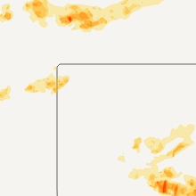
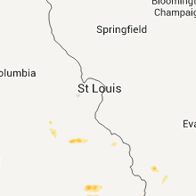
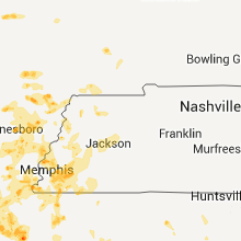
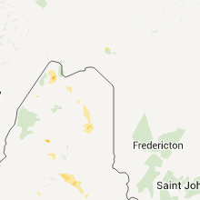
Hail Map for Thursday, June 16, 2011

Number of Impacted Households on 6/16/2011
0
Impacted by 1" or Larger Hail
0
Impacted by 1.75" or Larger Hail
0
Impacted by 2.5" or Larger Hail
Square Miles of Populated Area Impacted on 6/16/2011
0
Impacted by 1" or Larger Hail
0
Impacted by 1.75" or Larger Hail
0
Impacted by 2.5" or Larger Hail


Cities Most Affected by Hail Storms of 6/16/2011
| Hail Size | Demographics of Zip Codes Affected | ||||||
|---|---|---|---|---|---|---|---|
| City | Count | Average | Largest | Pop Density | House Value | Income | Age |
| Paragould, AR | 2 | 2.00 | 2.00 | 131 | $69k | $31.0k | 37.3 |
| Germantown, TN | 2 | 2.00 | 2.00 | 1845 | $265k | $116.2k | 44.4 |
| Altus, OK | 2 | 2.00 | 2.25 | 118 | $64k | $30.9k | 33.5 |
| Stuttgart, AR | 2 | 1.88 | 2.00 | 32 | $60k | $32.2k | 39.2 |
| Cunningham, KS | 2 | 1.75 | 1.75 | 3 | $48k | $33.1k | 50.4 |
| Mission, SD | 1 | 2.75 | 2.75 | 1 | $37k | $22.7k | 24.5 |
| Altus AFB, OK | 1 | 2.00 | 2.00 | 37 | $0k | $0.0k | 0.0 |
| Kinsman, OH | 1 | 2.00 | 2.00 | 57 | $90k | $37.1k | 44.6 |
| Gould, OK | 1 | 1.75 | 1.75 | 1 | $23k | $24.8k | 40.7 |
| Pratt, KS | 1 | 1.75 | 1.75 | 28 | $58k | $36.1k | 40.9 |
| Proctor, AR | 1 | 1.75 | 1.75 | 21 | $71k | $32.1k | 44.8 |
| Turon, KS | 1 | 1.75 | 1.75 | 3 | $31k | $28.1k | 44.3 |
| Barnard, KS | 1 | 1.75 | 1.75 | 1 | $16k | $35.0k | 45.8 |
| Portageville, MO | 1 | 1.75 | 1.75 | 23 | $58k | $29.0k | 40.2 |
| Paxton, NE | 1 | 1.75 | 1.75 | 2 | $55k | $30.8k | 43.4 |
| Cordova, TN | 1 | 1.75 | 1.75 | 1955 | $159k | $64.0k | 34.9 |
| Coats, KS | 1 | 1.75 | 1.75 | 1 | $17k | $33.4k | 37.5 |
| Lyon, MS | 1 | 1.75 | 1.75 | 22 | $50k | $23.2k | 37.2 |
Hail and Wind Damage Spotted on 6/16/2011
Filter by Report Type:Hail ReportsWind Reports
States Impacted
Georgia, Kansas, Alabama, Oklahoma, Maine, Mississippi, Wyoming, Ohio, Arkansas, Nebraska, Colorado, Pennsylvania, New York, Missouri, South Dakota, Tennessee, North Carolina, VirginiaGeorgia
| Local Time | Report Details |
|---|---|
| 1:12 PM UTC | Quarter sized hail reported near Lagrange, GA, 35.8 miles NE of Auburn, AL, quarter sized hail at bartley road and whitesville street. |
| 8:55 PM UTC | Quarter sized hail reported near Hazlehurst, GA, 20 miles NNE of Douglas, GA, quarter size hail was reported along the broxton highway. the time was based on radar. |
| 8:58 PM UTC | Large hail...likely golfball...in blakely and colomokee..and in between these towns in early county GA, 78.8 miles NNW of Tallahassee, FL |
| 8:58 PM UTC | Large hail..likely golfball in towns of colomokee and blakely and between towns in early county GA, 78.8 miles NNW of Tallahassee, FL |
| 9:13 PM UTC | Quarter sized hail reported near Cobb, GA, 72.5 miles WNW of Douglas, GA |
| 9:29 PM UTC | Telfair county 911 relayed reports of a tree downed on highway 117 between lumber city and jacksonvill in telfair county GA, 25.6 miles NNE of Douglas, GA |
| 9:35 PM UTC | Half Dollar sized hail reported near Hazlehurst, GA, 24 miles NNE of Douglas, GA, half dollar size hail was reported in roper. |
| 10:18 PM UTC | Trees were blown down and blocking jasper colston road at the broxton highwa in jeff davis county GA, 22.1 miles NNE of Douglas, GA |
| 10:18 PM UTC | Trees were blown down along bell telephone roa in jeff davis county GA, 23.8 miles NE of Douglas, GA |
| 2:15 AM UTC | An outflow boundary merged with a weak downburst near waverly and together they produced scattered tree damage across northern camden county between waverly and dover b in camden county GA, 52.4 miles N of Jacksonville, FL |
| 3:02 AM UTC | Dispatch center reported trees down on hwy 251 near the ben in mcintosh county GA, 50.5 miles SSW of Savannah, GA |
Kansas
| Local Time | Report Details |
|---|---|
| 1:59 PM UTC | Golf Ball sized hail reported near Barnard, KS, 72.9 miles ENE of Hays, KS |
| 4:42 PM UTC | Power pole dow in butler county KS, 14.7 miles ESE of Wichita, KS |
| 4:42 PM UTC | Power poll dow in butler county KS, 14.7 miles ESE of Wichita, KS |
| 5:21 PM UTC | Power pole down in cowley county KS, 39.8 miles ESE of Wichita, KS |
| 5:21 PM UTC | Power pole down in butler county KS, 37.4 miles ESE of Wichita, KS |
| 5:21 PM UTC | Power poll down in butler county KS, 37.4 miles ESE of Wichita, KS |
| 5:38 PM UTC | Storm damage reported in chautauqua county KS, 65.6 miles SE of Wichita, KS |
| 5:38 PM UTC | About 50 percent of the roof blown off a house. estimated wind speed 80 mp in chautauqua county KS, 60.8 miles SE of Wichita, KS |
| 5:51 PM UTC | Several street signs blown down. 4 to 5 inch diameter tree limbs snapped of in chautauqua county KS, 60.8 miles SE of Wichita, KS |
| 6:20 PM UTC | 5 inch tree limbs were downed in the town of chautauqua. wind gusts were estimated over 60 mp in chautauqua county KS, 60.8 miles SW of Chanute, KS |
| 10:01 PM UTC | Storm damage reported in finney county KS, 1 miles NE of Garden City, KS |
| 10:20 PM UTC | Storm damage reported in ford county KS, 39.2 miles ESE of Garden City, KS |
| 10:45 PM UTC | Quarter sized hail reported near Mullinville, KS, 79.8 miles N of Woodward, OK |
| 10:55 PM UTC | Storm damage reported in ford county KS, 3429 miles ENE of Caribou, ME |
| 11:00 PM UTC | Storm damage reported in lane county KS, 34.9 miles NE of Garden City, KS |
| 11:10 PM UTC | Quarter sized hail reported near Pratt, KS, 86.9 miles SSE of Hays, KS |
| 11:10 PM UTC | Storm damage reported in pratt county KS, 86.9 miles SSE of Hays, KS |
| 11:27 PM UTC | Quarter sized hail reported near Bazine, KS, 35.5 miles SSW of Hays, KS |
| 11:38 PM UTC | Quarter sized hail reported near Pratt, KS, 82.6 miles NNE of Woodward, OK |
| 11:40 PM UTC | Storm damage reported in pratt county KS, 69 miles W of Wichita, KS |
| 11:43 PM UTC | Ping Pong Ball sized hail reported near Kinsley, KS, 69.8 miles S of Hays, KS |
| 11:44 PM UTC | Golf Ball sized hail reported near Coats, KS, 80.6 miles NNE of Woodward, OK |
| 11:45 PM UTC | Storm damage reported in pawnee county KS, 47.5 miles SSW of Hays, KS |
| 11:52 PM UTC | Ping Pong Ball sized hail reported near Pratt, KS, 81.7 miles W of Wichita, KS |
| 11:57 PM UTC | Winds were estimated at 60 to 70 mp in ellis county KS, 10.9 miles ESE of Hays, KS |
| 11:59 PM UTC | Storm damage reported in pratt county KS, 65.2 miles W of Wichita, KS |
| 12:01 AM UTC | Quarter sized hail reported near Spearville, KS, 61.9 miles E of Garden City, KS |
| 12:02 AM UTC | A carport and flagpole were blown down in the city of culliso in pratt county KS, 85.9 miles W of Wichita, KS |
| 12:15 AM UTC | A semi was blown over at exit 157 on interstate 70. several highway signs were blown in ellis county KS, 3.1 miles NNW of Hays, KS |
| 12:16 AM UTC | Storm damage reported in ford county KS, 51.4 miles ESE of Garden City, KS |
| 12:16 AM UTC | Storm damage reported in pratt county KS, 63.9 miles W of Wichita, KS |
| 12:17 AM UTC | Storm damage reported in pratt county KS, 63.4 miles W of Wichita, KS |
| 12:24 AM UTC | Russell airport asos measures 58 mph wind gus in russell county KS, 27.6 miles E of Hays, KS |
| 12:32 AM UTC | Quarter sized hail reported near Hoisington, KS, 38.4 miles SE of Hays, KS, law enforcement reports quarter sized hail. |
| 12:37 AM UTC | Trained spotter estimates 60 to 70 mph wind gus in reno county KS, 59.9 miles W of Wichita, KS |
| 12:44 AM UTC | Storm damage reported in kingman county KS, 34.9 miles W of Wichita, KS |
| 12:57 AM UTC | Storm damage reported in ellsworth county KS, 49.8 miles E of Hays, KS |
| 12:59 AM UTC | Golf Ball sized hail reported near Pratt, KS, 73.7 miles W of Wichita, KS |
| 1:08 AM UTC | Trained spotter estimates 50 to 60 mph winds which sustained for at least 10 minute in lincoln county KS, 46.1 miles E of Hays, KS |
| 1:10 AM UTC | Emergency manager reports 60 mph wind in lincoln county KS, 57.9 miles ENE of Hays, KS |
| 1:17 AM UTC | Quarter sized hail reported near Mullinville, KS, 79.8 miles N of Woodward, OK, heavy rain and quarter sized hail was reported. |
| 1:17 AM UTC | Ping Pong Ball sized hail reported near Pratt, KS, 67.1 miles W of Wichita, KS |
| 1:20 AM UTC | Wind damage included a shed in ford county KS, 62.8 miles ESE of Garden City, KS |
| 1:25 AM UTC | At least 8 inch diameter tree limbs blown dow in edwards county KS, 69.1 miles S of Hays, KS |
| 1:26 AM UTC | Trained spotter along lincoln and russell county lines on highway 18 estimating 60 mph wind in russell county KS, 45.8 miles ENE of Hays, KS |
| 1:27 AM UTC | Quarter sized hail reported near Turon, KS, 60.5 miles W of Wichita, KS, trained spotter estimates quarter sized hail. |
| 1:30 AM UTC | Storm damage reported in pratt county KS, 85.9 miles W of Wichita, KS |
| 1:30 AM UTC | Storm damage reported in pawnee county KS, 50.9 miles SSW of Hays, KS |
| 1:32 AM UTC | Quarter sized hail reported near Turon, KS, 59.9 miles W of Wichita, KS |
| 1:35 AM UTC | Ping Pong Ball sized hail reported near Greensburg, KS, 78.7 miles S of Hays, KS |
| 1:37 AM UTC | Storm damage reported in lincoln county KS, 52.8 miles ENE of Hays, KS |
| 1:42 AM UTC | Emergency manager has multiple reports of 40 to 60 mph winds with one measured report of 62 mph across northwest portions of lincoln count in lincoln county KS, 56.7 miles ENE of Hays, KS |
| 1:45 AM UTC | Storm damage reported in stafford county KS, 69.8 miles SSE of Hays, KS |
| 1:47 AM UTC | Storm damage reported in pratt county KS, 75.3 miles W of Wichita, KS |
| 1:48 AM UTC | Storm damage reported in pratt county KS, 86.2 miles NNE of Woodward, OK |
| 1:51 AM UTC | Storm damage reported in pratt county KS, 67.8 miles W of Wichita, KS |
| 1:54 AM UTC | Quarter sized hail reported near Turon, KS, 59.9 miles W of Wichita, KS |
| 2:02 AM UTC | Golf Ball sized hail reported near Preston, KS, 67.3 miles W of Wichita, KS |
| 2:02 AM UTC | Storm damage reported in osborne county KS, 48.2 miles NE of Hays, KS |
| 2:02 AM UTC | Storm damage reported in pratt county KS, 67.3 miles W of Wichita, KS |
| 2:02 AM UTC | Trained spotter reports 30 to 45 minutes of winds from 60 to 70 mp in lincoln county KS, 50.9 miles E of Hays, KS |
| 2:03 AM UTC | Storm damage reported in cheyenne county KS, 35.5 miles NW of Colby, KS |
| 2:03 AM UTC | A ten to twelve inch diameter tree was blown down. four to five inch diameter tree limbs were blown down. a hotel sign was blown down. this damage occurred in the west in pratt county KS, 77 miles W of Wichita, KS |
| 2:04 AM UTC | Storm damage reported in kiowa county KS, 80.5 miles N of Woodward, OK |
| 2:04 AM UTC | Quarter sized hail reported near Haviland, KS, 80.5 miles N of Woodward, OK |
| 2:09 AM UTC | Quarter sized hail reported near Haviland, KS, 83.4 miles N of Woodward, OK |
| 2:13 AM UTC | Storm damage reported in ellsworth county KS, 66.8 miles E of Hays, KS |
| 2:13 AM UTC | Storm damage reported in pratt county KS, 78.4 miles NNE of Woodward, OK |
| 2:15 AM UTC | Awos at ellsworth airport measures 58 mph wind gus in ellsworth county KS, 59.8 miles E of Hays, KS |
| 2:24 AM UTC | Ellsworth airport awos measures 62 mph wind in ellsworth county KS, 59.8 miles E of Hays, KS |
| 2:28 AM UTC | Blew vehicle off the road...light poles knocked dow in pratt county KS, 80.8 miles NNE of Woodward, OK |
| 2:30 AM UTC | 3 to 4 inch diameter tree limbs down. delayed repor in ellsworth county KS, 72 miles ESE of Hays, KS |
| 2:31 AM UTC | Spotter reporting several 4 inch tree branches knocked down on stree in pratt county KS, 77 miles W of Wichita, KS |
| 2:32 AM UTC | Storm damage reported in edwards county KS, 68.3 miles S of Hays, KS |
| 2:33 AM UTC | Shingles ripped off of houses in town. power outages as wel in osborne county KS, 51.9 miles NE of Hays, KS |
| 2:33 AM UTC | Trees 1-2 feet in diameter...along with several smaller limbs...were knocked down across town. two metal buildings were also damaged...one had a door and wall blown out in osborne county KS, 51.9 miles NE of Hays, KS |
| 2:35 AM UTC | Storm damage reported in lincoln county KS, 73.5 miles E of Hays, KS |
| 2:36 AM UTC | Ksn weatherlab at windom elementary school measures 60 mph wind in mcpherson county KS, 57.2 miles NNW of Wichita, KS |
| 2:38 AM UTC | Storm damage reported in pratt county KS, 81.8 miles W of Wichita, KS |
| 2:45 AM UTC | Trained spotter estimates 60 mph winds along city limits of kingma in kingman county KS, 42.5 miles W of Wichita, KS |
| 2:46 AM UTC | Trained spotter measures winds to be 60 to 64 mp in reno county KS, 60.5 miles W of Wichita, KS |
| 2:46 AM UTC | Kake storm chaser estimates 65 mph wind in lincoln county KS, 73.5 miles E of Hays, KS |
| 2:55 AM UTC | Emergency manager reports power pole snapped in half at the intersection of yoder and pleasant valley road in reno county KS, 31.3 miles WNW of Wichita, KS |
| 3:00 AM UTC | Golf Ball sized hail reported near Cunningham, KS, 60.6 miles W of Wichita, KS, trained spotter reports golfball sized hail. |
| 3:03 AM UTC | Salina airport asos measures 61 mph wind in saline county KS, 64.1 miles WSW of Manhattan, KS |
| 3:05 AM UTC | Trained spotter estimates 70 mph winds on highway 54 just 1 mile inside the county lin in sedgwick county KS, 24.4 miles W of Wichita, KS |
| 3:05 AM UTC | Irrigation system blown over at sw 70th ave and 90th stree in pratt county KS, 80 miles NNE of Woodward, OK |
| 3:11 AM UTC | Golf Ball sized hail reported near Cunningham, KS, 60.6 miles W of Wichita, KS, trained spotter reports golfball sized hail. |
| 3:27 AM UTC | Salina airport asos measures 77 mph wind gus in saline county KS, 64.1 miles WSW of Manhattan, KS |
| 3:28 AM UTC | Trained spotter measured 59 mph wind gus in mcpherson county KS, 62.1 miles NNW of Wichita, KS |
| 3:30 AM UTC | Emergency manager reported an 18 to 20 inch tree went through a roof with time estimate based on rada in saline county KS, 65.7 miles WSW of Manhattan, KS |
| 3:30 AM UTC | Emergency manager reported several signs blown over at the national guard armory. an air conditioning unit of unknown size was blown off the roof at k-state salina. est in saline county KS, 62.1 miles WSW of Manhattan, KS |
| 3:43 AM UTC | Emergency manager reports 2 to 8 inch limbs down which has blocked the roadway. several powerlines are down and several transformers have blow in saline county KS, 65.7 miles WSW of Manhattan, KS |
| 3:45 AM UTC | Storm damage reported in mcpherson county KS, 62.1 miles NNW of Wichita, KS |
| 3:45 AM UTC | Storm damage reported in sumner county KS, 31.7 miles SSW of Wichita, KS |
| 3:50 AM UTC | Delayed repor in mcpherson county KS, 63.6 miles NNW of Wichita, KS |
Alabama
| Local Time | Report Details |
|---|---|
| 3:26 PM UTC | Quarter sized hail reported near Notasulga, AL, 15.8 miles W of Auburn, AL, dimes to quarters reported on hwy 14 at cr 38. |
| 3:33 PM UTC | Quarter sized hail reported near Notasulga, AL, 15.8 miles W of Auburn, AL, dimes to quarters reported on hwy 14 at cr 38. |
| 4:29 PM UTC | Quarter sized hail reported near Opelika, AL, 8.4 miles ESE of Auburn, AL, dime to quarter size hail fell along moores mill road. |
| 6:49 PM UTC | Quarter sized hail reported near Mobile, AL, 5.1 miles WNW of Mobile, AL, quarter size hail on interstate 65 one mile north of airport blvd. |
| 7:04 PM UTC | Tree down just east of university ave at airport blv in mobile county AL, 7 miles W of Mobile, AL |
| 7:04 PM UTC | Tree down at hillcrest road and cottage hill roa in mobile county AL, 8.5 miles WSW of Mobile, AL |
| 7:04 PM UTC | Quarter sized hail reported near Mobile, AL, 8.5 miles WSW of Mobile, AL, quarter size hail hillcrest road at cottage hill road. |
| 7:30 PM UTC | Large tree limbs snapped off and lots of debris in the roadway on county road 10 and highway 1 in sumter county AL, 58.7 miles WNW of Camden, AL |
| 7:45 PM UTC | Ping Pong Ball sized hail reported near Wilmer, AL, 24.4 miles WNW of Mobile, AL, walnut size hail near the alabama - mississippi state line on highway 98. |
| 8:58 PM UTC | Multiple trees and powerlines down across county especially in vicinity of halebur in henry county AL, 84.1 miles NW of Tallahassee, FL |
| 9:45 PM UTC | Trees and power lines down in conecuh county AL, 43.7 miles SSE of Camden, AL |
| 9:55 PM UTC | Several trees down in city of webb at highway 52 east. marble size hai in houston county AL, 81.6 miles NW of Tallahassee, FL |
| 10:15 PM UTC | Powerlines/trees down highway 52 between webb and columbia. quarter size hail highway 84 west of dothan in houston county AL, 81.6 miles NW of Tallahassee, FL |
| 10:15 PM UTC | Trees and powerlines down highway 22e between webb and columbia. quarter size hail highway 84w west of dothan in houston county AL, 81.6 miles NW of Tallahassee, FL |
| 10:15 PM UTC | Powerlines/trees down...roof damage to chicken house se end of county. quarter size hai in henry county AL, 81 miles SSE of Auburn, AL |
| 10:15 PM UTC | Powerlines/trees dwon...roof damage to chicken house se end of county. quarter size hai in dale county AL, 81.1 miles NNE of Miramar Beach, FL |
| 10:20 PM UTC | Trees/powerlines down in echo and ewel in dale county AL, 82 miles S of Auburn, AL |
| 10:30 PM UTC | Powerlines/trees down. roof damage chicken coop/house se end of county. large hail undetermined siz in dale county AL, 77 miles NNE of Miramar Beach, FL |
| 10:30 PM UTC | A tree was knocked down in simcoe on highway 6 in cullman county AL, 48.5 miles N of Birmingham, AL |
| 11:46 PM UTC | A couple of trees were reported down along hwy 24 e of russellvill in franklin county AL, 22.8 miles S of Florence, AL |
| 12:30 AM UTC | Dolly creek convenience gas station of acton road had front canopy ripped off landing on a vehicl in jefferson county AL, 8.2 miles SSE of Birmingham, AL |
Oklahoma
| Local Time | Report Details |
|---|---|
| 4:20 PM UTC | Quarter sized hail reported near Fairfax, OK, 56.3 miles NW of Tulsa, OK, estimated 60 mph winds and small tree limbs also reportedly downed. time estimated via radar. |
| 6:10 PM UTC | Shingles ripped off roofs. motorcycles flipped. childrens swing sets tosse in osage county OK, 58.1 miles NNW of Tulsa, OK |
| 6:25 PM UTC | Several trees blown down in the bowring area. time estimate in osage county OK, 50.9 miles N of Tulsa, OK |
| 7:00 PM UTC | Estimated 50 to 60 mph winds and torrential rain. time estimated via rada in washington county OK, 51.9 miles N of Tulsa, OK |
| 11:23 PM UTC | Golf Ball sized hail reported near Gould, OK, 33.3 miles NE of Childress, TX |
| 12:11 AM UTC | Half Dollar sized hail reported near Carter, OK, 70 miles NE of Childress, TX |
| 12:22 AM UTC | Quarter sized hail reported near Altus, OK, 49.9 miles ENE of Childress, TX |
| 12:22 AM UTC | Half Dollar sized hail reported near Altus, OK, 50.7 miles ENE of Childress, TX |
| 7:30 PM CDT | Hen Egg sized hail reported near Altus, OK, 52.9 miles ENE of Childress, TX, large hail continued for approximately 30 minutes 1.5 miles nnw of altus. windows were broken at a residence. the windshield of a car in the driveway was broken. |
| 12:38 AM UTC | Hen Egg sized hail reported near Altus, OK, 54.9 miles ENE of Childress, TX, numerous automobiles had their windshields broken from the large hail. |
| 7:38 PM CDT | Golf Ball sized hail reported near Altus, OK, 52.9 miles ENE of Childress, TX, the hail was reported at main street and tamarack road. |
| 12:45 AM UTC | Storm damage reported in jackson county OK, 54.9 miles ENE of Childress, TX |
| 12:54 AM UTC | Half Dollar sized hail reported near Altus, OK, 59 miles ENE of Childress, TX |
| 1:00 AM UTC | Storm damage reported in jackson county OK, 51.5 miles ENE of Childress, TX |
| 1:05 AM UTC | Storm damage reported in jackson county OK, 51.5 miles ENE of Childress, TX |
| 1:07 AM UTC | Ping Pong Ball sized hail reported near Headrick, OK, 61.7 miles NW of Wichita Falls, TX |
| 1:10 AM UTC | Storm damage reported in jackson county OK, 51.5 miles ENE of Childress, TX |
| 1:11 AM UTC | Storm damage reported in jackson county OK, 54.9 miles ENE of Childress, TX |
| 1:15 AM UTC | Storm damage reported in jackson county OK, 51.5 miles ENE of Childress, TX |
| 1:15 AM UTC | Storm damage reported in jackson county OK, 54.9 miles ENE of Childress, TX |
| 1:19 AM UTC | Storm damage reported in jackson county OK, 54.9 miles ENE of Childress, TX |
| 1:24 AM UTC | Quarter sized hail reported near Headrick, OK, 61.7 miles NW of Wichita Falls, TX |
| 1:25 AM UTC | The roof at the friendship inn in altus has been damaged. roof damage was also reported the the tabernacle church. traffic lights are also damaged in altus. severe wind in jackson county OK, 51.5 miles ENE of Childress, TX |
| 1:25 AM UTC | The roof at the friendship inn in altus has been damaged. traffic lights are also damaged in altus. severe wind gusts have continued for at least the last 20 minute in jackson county OK, 51.5 miles ENE of Childress, TX |
| 1:41 AM UTC | Storm damage reported in jackson county OK, 54.9 miles ENE of Childress, TX |
| 1:51 AM UTC | Quarter sized hail reported near Manitou, OK, 49.7 miles NNW of Wichita Falls, TX |
| 1:55 AM UTC | Roof damage was reported to the hospital in frederick. a home also susatined roof and car port damag in tillman county OK, 44.2 miles NW of Wichita Falls, TX |
| 2:00 AM UTC | Storm damage reported in comanche county OK, 56.7 miles N of Wichita Falls, TX |
| 2:05 AM UTC | Storm damage reported in comanche county OK, 56.7 miles N of Wichita Falls, TX |
| 2:40 AM UTC | Storm damage reported in tillman county OK, 26.1 miles NNW of Wichita Falls, TX |
| 2:45 AM UTC | Minor roof damage. shingles blown off at least 3 roofs near s.e. 45th st and hwy 7 in comanche county OK, 48 miles N of Wichita Falls, TX |
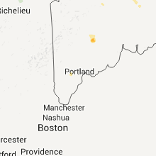
Maine
| Local Time | Report Details |
|---|---|
| 7:20 PM UTC | Quarter sized hail reported near Rome, ME, 56.1 miles WSW of Bangor, ME |
| 7:22 PM UTC | Quarter sized hail reported near Rome, ME, 58 miles WSW of Bangor, ME |
| 7:35 PM UTC | Half Dollar sized hail reported near Belgrade, ME, 57.6 miles WSW of Bangor, ME |
| 7:39 PM UTC | Half Dollar sized hail reported near Belgrade, ME, 57.6 miles WSW of Bangor, ME |
| 7:58 PM UTC | Quarter sized hail reported near Sidney, ME, 52.2 miles WSW of Bangor, ME |
| 8:01 PM UTC | Quarter sized hail reported near Ashland, ME, 25.2 miles SW of Caribou, ME, hail covered the ground |
Mississippi
| Local Time | Report Details |
|---|---|
| 7:30 PM UTC | A small tree and tree branches were downed...partially blocking highway 4 in clay county MS, 19.7 miles NNW of Starkville, MS |
| 8:21 PM UTC | Quarter sized hail reported near Shuqualak, MS, 35.3 miles SSE of Starkville, MS, covered the ground along jones rd |
| 9:40 PM UTC | A few trees were down along stewart-lodi rd in webster county MS, 36.8 miles W of Starkville, MS |
| 9:44 PM UTC | A couple trees were down in choctaw county MS, 21.9 miles WSW of Starkville, MS |
| 9:44 PM UTC | Quarter sized hail reported near Ackerman, MS, 21.9 miles WSW of Starkville, MS, on collier rd |
| 9:45 PM UTC | A tree fell on a house along skyland dr in lauderdale county MS, 78.6 miles S of Starkville, MS |
| 9:45 PM UTC | Trees downed at the intersection of hwy 45 and hwy 14 in lauderdale county MS, 80 miles S of Starkville, MS |
| 10:05 PM UTC | Half Dollar sized hail reported near Weir, MS, 26.5 miles WSW of Starkville, MS |
| 10:08 PM UTC | Quarter sized hail reported near McCool, MS, 35.6 miles WSW of Starkville, MS, covered the ground on the south side of town |
| 10:10 PM UTC | Half Dollar sized hail reported near Weir, MS, 26.5 miles WSW of Starkville, MS |
| 10:35 PM UTC | 4 to 6 inch limbs down along hwy 315 just outside of sardi in panola county MS, 50.2 miles S of Memphis, TN |
| 10:46 PM UTC | Quarter sized hail reported near Como, MS, 44.5 miles S of Memphis, TN |
| 10:46 PM UTC | A few trees down near hwy 310 outside of com in panola county MS, 44.5 miles S of Memphis, TN |
| 10:50 PM UTC | Quarter sized hail reported near Philadelphia, MS, 45 miles SSW of Starkville, MS, reported along county road 397. |
| 11:02 PM UTC | Half Dollar sized hail reported near Carthage, MS, 55.1 miles SSW of Starkville, MS |
| 11:58 PM UTC | Quarter sized hail reported near , , 12.7 miles SSE of Memphis, TN, quarter size hail near elmore and goodman |
| 12:02 AM UTC | Quarter sized hail reported near Canton, MS, 35.5 miles NE of Jackson, MS, covered the ground and lasted for 15 min |
| 12:02 AM UTC | Tree down on powerline in tate county MS, 39.7 miles SSE of Memphis, TN |
| 12:24 AM UTC | A few trees were down on power lines in scott county MS, 38.6 miles ENE of Jackson, MS |
| 12:40 AM UTC | Quarter sized hail reported near Olive Branch, MS, 18.5 miles SE of Memphis, TN, quarter size hail near hwy 78 and magnolia drive. |
| 2:14 AM UTC | Quarter sized hail reported near Clarksdale, MS, 72.1 miles SSW of Memphis, TN |
| 2:16 AM UTC | Quarter sized hail reported near Clarksdale, MS, 72.1 miles SSW of Memphis, TN |
| 2:17 AM UTC | Golf Ball sized hail reported near Lyon, MS, 69.9 miles SSW of Memphis, TN, quarter to golf ball size hail in lyon |
Wyoming
| Local Time | Report Details |
|---|---|
| 8:15 PM UTC | Quarter sized hail reported near Cheyenne, WY, 45.5 miles ENE of Laramie, WY, estimate 60 mph winds. |
| 8:19 PM UTC | Quarter sized hail reported near Torrington, WY, 33.5 miles WNW of Scottsbluff, NE |
| 8:27 PM UTC | Half Dollar sized hail reported near Cheyenne, WY, 43.2 miles ENE of Laramie, WY |
| 8:32 PM UTC | Half Dollar sized hail reported near Cheyenne, WY, 44.6 miles ENE of Laramie, WY |
| 8:40 PM UTC | Quarter sized hail reported near Yoder, WY, 31.4 miles W of Scottsbluff, NE, some nickle sized also. 45 mph winds. |
| 9:18 PM UTC | Quarter sized hail reported near Torrington, WY, 23.9 miles W of Scottsbluff, NE |
| 10:30 PM UTC | Kpat - pathfinder hill in natrona county WY, 32.2 miles SW of Casper, WY |
| 10:36 PM UTC | Est from alcova marina in natrona county WY, 28.8 miles SW of Casper, WY |
| 10:36 PM UTC | Est from pathfinder reservoir marina in natrona county WY, 36.6 miles SW of Casper, WY |
| 10:36 PM UTC | Est wind gust from pathfinder reservoir marina in natrona county WY, 36.6 miles SW of Casper, WY |
| 10:43 PM UTC | Thunderstorm wind gusts estimated at 60 to 65 mp in natrona county WY, 20.9 miles SW of Casper, WY |
| 11:28 PM UTC | Healthy 3in diameter tree limbs down in casper at 10th and beverly street in natrona county WY, 1.4 miles S of Casper, WY |
| 11:28 PM UTC | Healthy 3in diameter tree limbs down in casper at 10th and beverly street in natrona county WY, 5.6 miles WNW of Casper, WY |
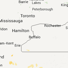
Ohio
| Local Time | Report Details |
|---|---|
| 8:18 PM UTC | Storm damage reported in summit county OH, 34 miles SSE of Cleveland, OH |
| 9:20 PM UTC | Hen Egg sized hail reported near Kinsman, OH, 58.9 miles E of Cleveland, OH |
| 9:40 PM UTC | Trees down on state route 724 in monroe county OH, 83.3 miles SW of Pittsburgh, PA |
Arkansas
| Local Time | Report Details |
|---|---|
| 9:00 PM UTC | Half Dollar sized hail reported near Grady, AR, 63.7 miles SE of Little Rock, AR |
| 9:00 PM UTC | Hen Egg sized hail reported near Paragould, AR, 67.4 miles NNW of Memphis, TN, 2 inch hail...damaged metal roof of office building and a couple greenhouses. |
| 9:05 PM UTC | Quarter sized hail reported near De Witt, AR, 60.3 miles ESE of Little Rock, AR |
| 9:11 PM UTC | Quarter sized hail reported near De Witt, AR, 59.6 miles ESE of Little Rock, AR |
| 9:24 PM UTC | Hen Egg sized hail reported near Paragould, AR, 67.4 miles NNW of Memphis, TN, 2 inch hail...damaged metal roof of office building and a couple greenhouses. |
| 9:30 PM UTC | Quarter sized hail reported near Biggers, AR, 91.9 miles NNW of Memphis, TN, dime to quarter size hail reported in the town of biggers. exact time estimated by radar. |
| 9:33 PM UTC | Quarter sized hail reported near Paragould, AR, 69.5 miles NNW of Memphis, TN, quarter sized hail near highway 141. |
| 9:44 PM UTC | Quarter sized hail reported near Jonesboro, AR, 58.7 miles NW of Memphis, TN |
| 9:50 PM UTC | Quarter sized hail reported near Jonesboro, AR, 55.5 miles NW of Memphis, TN |
| 10:23 PM UTC | Golf Ball sized hail reported near Stuttgart, AR, 41.3 miles ESE of Little Rock, AR |
| 10:23 PM UTC | Hen Egg sized hail reported near Stuttgart, AR, 38.4 miles ESE of Little Rock, AR, hail size inferred from picture of rear car window with large holes in it. hail could have been larger. |
| 10:28 PM UTC | Quarter sized hail reported near Bay, AR, 49.9 miles NW of Memphis, TN, nickel to quarter size hail. |
| 10:30 PM UTC | Quarter sized hail reported near Cherry Valley, AR, 43.2 miles WNW of Memphis, TN, hail started as pea size...and eventually reahced quarter size hail in cherry valley 4 minutes later. |
| 10:30 PM UTC | Golf Ball sized hail reported near Proctor, AR, 17.1 miles WSW of Memphis, TN, upto golf ball sized hail in neuhardt. |
| 10:30 PM UTC | 1 tree down...numerous branches down in the town of cherry valle in cross county AR, 43.2 miles WNW of Memphis, TN |
| 10:33 PM UTC | A few trees down and a trampoline flipped in the town of recto in clay county AR, 77.7 miles N of Memphis, TN |
| 10:36 PM UTC | Quarter sized hail reported near Moro, AR, 64.8 miles E of Little Rock, AR, hail nearly covering the ground. |
| 10:37 PM UTC | Scattered powerlines down in the town of moro...reported by woodruff electri in lee county AR, 58.9 miles WSW of Memphis, TN |
| 10:37 PM UTC | Several trees down in tow in lee county AR, 58.9 miles WSW of Memphis, TN |
| 10:40 PM UTC | Ping Pong Ball sized hail reported near Marianna, AR, 52.5 miles WSW of Memphis, TN, quarter to ping pong ball sized hail near highway 79 |
| 10:55 PM UTC | Quarter sized hail reported near Proctor, AR, 17.1 miles WSW of Memphis, TN, quarter sized hail now in neuhardt. |
| 11:51 PM UTC | Trees down in crittenden county AR, 16.8 miles WNW of Memphis, TN |
| 12:05 AM UTC | Quarter sized hail reported near Wynne, AR, 42.3 miles W of Memphis, TN, time is estimated. |
Nebraska
| Local Time | Report Details |
|---|---|
| 9:15 PM UTC | Quarter sized hail reported near Mitchell, NE, 12.2 miles WNW of Scottsbluff, NE, lasted 30 minutes. |
| 9:25 PM UTC | Quarter sized hail reported near Lyman, NE, 19.9 miles WNW of Scottsbluff, NE |
| 9:30 PM UTC | Graineries blown down. tree branches down. 70 mph winds estimate in scotts bluff county NE, 16.3 miles WNW of Scottsbluff, NE |
| 9:30 PM UTC | Ping Pong Ball sized hail reported near Mitchell, NE, 11.4 miles WNW of Scottsbluff, NE, lasted 5 minutes. |
| 9:45 PM UTC | Quarter sized hail reported near Lyman, NE, 19.9 miles WNW of Scottsbluff, NE |
| 9:49 PM UTC | Peak gust 54 k in scotts bluff county NE, 0.6 miles NNE of Scottsbluff, NE |
| 9:49 PM UTC | 1-2 inch tree branches down throughout the cit in scotts bluff county NE, 0.6 miles NNE of Scottsbluff, NE |
| 9:50 PM UTC | Spotter reported several good sized trees blown over in the scottsbluff area. estimates winds to have been 60 to 65 mp in scotts bluff county NE, 0.6 miles NNE of Scottsbluff, NE |
| 9:56 PM UTC | Estimate winds from 50 to 60 mph in scotts bluff county NE, 10 miles ENE of Scottsbluff, NE |
| 10:02 PM UTC | Storm damage reported in scotts bluff county NE, 0.6 miles NNE of Scottsbluff, NE |
| 10:09 PM UTC | Storm damage reported in scotts bluff county NE, 0.6 miles NNE of Scottsbluff, NE |
| 10:30 PM UTC | Quarter sized hail reported near Merriman, NE, 46.2 miles W of Valentine, NE |
| 10:30 PM UTC | Quarter sized hail reported near Merriman, NE, 48.2 miles W of Valentine, NE |
| 10:35 PM UTC | Storm damage reported in morrill county NE, 32 miles ESE of Scottsbluff, NE |
| 10:35 PM UTC | Heavy rain as wel in morrill county NE, 32 miles ESE of Scottsbluff, NE |
| 10:35 PM UTC | Numerous tree limbs and branches blown down. one 16 inch tree was split in hal in morrill county NE, 32 miles ESE of Scottsbluff, NE |
| 10:41 PM UTC | Half Dollar sized hail reported near Cody, NE, 45.2 miles W of Valentine, NE |
| 10:41 PM UTC | Ping Pong Ball sized hail reported near Merriman, NE, 67.9 miles WSW of Valentine, NE |
| 10:42 PM UTC | Quarter sized hail reported near Alliance, NE, 31.1 miles ENE of Scottsbluff, NE, 45 to 50 mph winds. |
| 10:53 PM UTC | Storm damage reported in box butte county NE, 44 miles ENE of Scottsbluff, NE |
| 10:56 PM UTC | Storm damage reported in box butte county NE, 44 miles ENE of Scottsbluff, NE |
| 10:57 PM UTC | Graineries blown down. tree branches down. 70 mph winds estimate in scotts bluff county NE, 16.3 miles WNW of Scottsbluff, NE |
| 11:35 PM UTC | Estimated 60 mile per hour winds with 4 inch diameter branches broken off in garden county NE, 68.7 miles E of Scottsbluff, NE |
| 11:35 PM UTC | Quarter sized hail reported near Gordon, NE, 86.5 miles WSW of Valentine, NE, winds up to 40 mph. |
| 11:50 PM UTC | Quarter sized hail reported near Gordon, NE, 81.9 miles WSW of Valentine, NE |
| 12:10 AM UTC | Quarter sized hail reported near Kimball, NE, 44.3 miles S of Scottsbluff, NE, intersection of interstate 80 and highway 71. |
| 12:28 AM UTC | Quarter sized hail reported near Dix, NE, 43.8 miles S of Scottsbluff, NE, nickel to quarter hail coming down very hard |
| 12:30 AM UTC | Quarter sized hail reported near Dix, NE, 44.2 miles S of Scottsbluff, NE |
| 12:30 AM UTC | Estimated 5 inch branches were down due to win in cherry county NE, 66.7 miles WSW of Valentine, NE |
| 12:35 AM UTC | Hail up to quarter size also reporte in arthur county NE, 60.1 miles WNW of North Platte, NE |
| 12:55 AM UTC | Quarter sized hail reported near Arthur, NE, 60.2 miles NW of North Platte, NE |
| 12:55 AM UTC | Storm damage reported in arthur county NE, 60.2 miles NW of North Platte, NE |
| 12:57 AM UTC | Quarter sized hail reported near Arthur, NE, 49.4 miles NW of North Platte, NE, also estimated 60 mile per hour wind gusts |
| 12:58 AM UTC | Storm damage reported in cherry county NE, 56.6 miles SW of Valentine, NE |
| 1:05 AM UTC | Pickup truck and attached camper tipped over due to strong wind gusts near mile marker 70 on interstate 8 in cheyenne county NE, 69.6 miles SE of Scottsbluff, NE |
| 1:06 AM UTC | Dime to quarter sized was also falling at this tim in cheyenne county NE, 69.8 miles N of Yuma, CO |
| 1:20 AM UTC | Storm damage reported in cherry county NE, 32.3 miles SSW of Valentine, NE |
| 1:22 AM UTC | Quarter sized hail reported near Chappell, NE, 71.7 miles N of Yuma, CO |
| 1:25 AM UTC | Trampoline took flight and hit house damaging an outside faucet and gutter damaged. trampoline tumbled down hill from hous in deuel county NE, 68.3 miles N of Yuma, CO |
| 1:35 AM UTC | Porch blown off of house in deuel county NE, 69.6 miles NNE of Yuma, CO |
| 1:45 AM UTC | Storm damage reported in cherry county NE, 29.3 miles S of Valentine, NE |
| 1:50 AM UTC | Storm damage reported in perkins county NE, 61 miles WSW of North Platte, NE |
| 1:58 AM UTC | Storm damage reported in cherry county NE, 0.3 miles S of Valentine, NE |
| 2:00 AM UTC | 3 to 4 inch branches were snapped off in brown county NE, 48.3 miles SE of Valentine, NE |
| 2:00 AM UTC | Estimated wind gusts of at least 60 mph along with quarter sized hai in perkins county NE, 57.2 miles WSW of North Platte, NE |
| 2:00 AM UTC | Quarter sized hail reported near Venango, NE, 57.2 miles WSW of North Platte, NE |
| 2:09 AM UTC | Quarter sized hail reported near Grant, NE, 54.5 miles WSW of North Platte, NE |
| 2:10 AM UTC | Half Dollar sized hail reported near Grant, NE, 54.5 miles WSW of North Platte, NE, large marble to half dollar sized hail nearly covering the ground. |
| 2:15 AM UTC | Gust to 63 mph was recorded by automatic equipment at the ainsworth airpor in brown county NE, 41.7 miles ESE of Valentine, NE |
| 2:15 AM UTC | Storm damage reported in brown county NE, 35.2 miles ESE of Valentine, NE |
| 2:49 AM UTC | Golf Ball sized hail reported near Paxton, NE, 31.2 miles W of North Platte, NE |
| 3:07 AM UTC | Storm damage reported in red willow county NE, 61.7 miles NNE of Colby, KS |
| 3:12 AM UTC | Quarter sized hail reported near North Platte, NE, 17.1 miles S of North Platte, NE, mostly nickel sized hail along with very heavy rainfall at time of report. |
| 3:12 AM UTC | Storm damage reported in red willow county NE, 61.7 miles NNE of Colby, KS |
| 3:15 AM UTC | Coop observer estimated wind speeds in excess of 60 mph with several tree limbs down. time for this reported is estimate in frontier county NE, 46.4 miles SSE of North Platte, NE |
| 3:37 AM UTC | Storm damage reported in dawson county NE, 35.5 miles ESE of North Platte, NE |
| 3:45 AM UTC | Storm damage reported in dawson county NE, 35.5 miles ESE of North Platte, NE |
| 3:45 AM UTC | Public reported 60 mph wind gusts in cozad. road signs were blown over along highway 30. plastic fencing and pipes also blown over from the nebraska plastic plan in dawson county NE, 44.7 miles ESE of North Platte, NE |
| 3:50 AM UTC | Several tree limbs down in cozad. limbs are around 4 to 5 inches in diameter with at least one branch 8 inches in diamete in dawson county NE, 44.7 miles ESE of North Platte, NE |
| 3:55 AM UTC | Storm damage reported in dawson county NE, 56.7 miles ESE of North Platte, NE |
| 3:57 AM UTC | Storm damage reported in dawson county NE, 58.9 miles ESE of North Platte, NE |
| 4:15 AM UTC | Storm damage reported in gosper county NE, 57.2 miles ESE of North Platte, NE |
| 6:35 AM UTC | Quarter sized hail reported near Norfolk, NE, 69 miles ESE of Oneill, NE |
Colorado
| Local Time | Report Details |
|---|---|
| 9:33 PM UTC | Storm damage reported in adams county CO, 36.9 miles E of Denver, CO |
| 10:04 PM UTC | Storm damage reported in douglas county CO, 20.1 miles SE of Denver, CO |
| 10:18 PM UTC | Sustained winds 30 to 40 mph. davis wx equi in arapahoe county CO, 30.9 miles E of Denver, CO |
| 10:32 PM UTC | Storm damage reported in washington county CO, 46.4 miles WSW of Yuma, CO |
| 10:37 PM UTC | South winds sustained at 31 mph. davis wx equi in adams county CO, 36.9 miles E of Denver, CO |
| 10:40 PM UTC | 20 to 40 foot section of barn knocked over along with several trees uprooted and or knocked dow in arapahoe county CO, 34.2 miles E of Denver, CO |
| 10:53 PM UTC | Winds 35046g77 mph at 1649 mdt in lincoln county CO, 76.8 miles ESE of Denver, CO |
| 11:00 PM UTC | Estimated wind gusts 50 to 60 mp in lincoln county CO, 76.8 miles ESE of Denver, CO |
| 11:50 PM UTC | Half Dollar sized hail reported near Kirk, CO, 36.6 miles SSE of Yuma, CO |
| 12:05 AM UTC | Storm damage reported in kit carson county CO, 47.5 miles S of Yuma, CO |
| 12:12 AM UTC | I-70 mile marke in lincoln county CO, 76.8 miles ESE of Denver, CO |
| 12:14 AM UTC | Lost cattle building and several tree tops in washington county CO, 25.3 miles WNW of Yuma, CO |
| 12:20 AM UTC | Storm damage reported in yuma county CO, 7.8 miles N of Yuma, CO |
| 12:20 AM UTC | Relayed from espotter network. shingles blown off in kit carson county CO, 56.5 miles S of Yuma, CO |
| 12:30 AM UTC | Storm damage reported in kit carson county CO, 57 miles S of Yuma, CO |
| 12:30 AM UTC | Porch destroyed and three trees uprooted in kit carson county CO, 44.5 miles S of Yuma, CO |
| 12:58 AM UTC | Storm damage reported in douglas county CO, 24.8 miles SSE of Denver, CO |
| 1:15 AM UTC | Quarter sized hail reported near Idalia, CO, 36.8 miles SE of Yuma, CO |
| 1:40 AM UTC | Quarter sized hail reported near Loveland, CO, 52.2 miles NNW of Denver, CO |
| 1:53 AM UTC | Half Dollar sized hail reported near Fort Collins, CO, 56.7 miles N of Denver, CO, one inch to 1 1/4 inch hail. no wind. no rain. |
| 2:00 AM UTC | Quarter sized hail reported near Fort Collins, CO, 56.7 miles N of Denver, CO, most hail penny size. |
| 2:10 AM UTC | Quarter sized hail reported near Fort Collins, CO, 56.7 miles N of Denver, CO |
Pennsylvania
| Local Time | Report Details |
|---|---|
| 9:34 PM UTC | Storm damage reported in mercer county PA, 65.1 miles E of Cleveland, OH |
| 9:36 PM UTC | Power reported out of service in greenville in mercer county PA, 68.3 miles E of Cleveland, OH |
New York
| Local Time | Report Details |
|---|---|
| 10:45 PM UTC | Tree dow in chautauqua county NY, 57.3 miles SSW of Buffalo, NY |
| 10:45 PM UTC | Trees and lines dow in chautauqua county NY, 57.3 miles SSW of Buffalo, NY |
Missouri
| Local Time | Report Details |
|---|---|
| 10:45 PM UTC | Trees down in kennett in dunklin county MO, 75.2 miles N of Memphis, TN |
| 10:50 PM UTC | Farm shopt lost roof and back wall near county road 535 and hwy in dunklin county MO, 73.8 miles N of Memphis, TN |
| 7:20 AM UTC | Golf Ball sized hail reported near Portageville, MO, 64.7 miles WNW of Mc Kenzie, TN, wardell fire department reported golfball size hail 6 miles southeast of portageville or about 3 miles southwest of stewart. |
| 8:16 AM UTC | Quarter sized hail reported near Williamsville, MO, 58.2 miles WSW of Cape Girardeau, MO |
South Dakota
| Local Time | Report Details |
|---|---|
| 11:00 PM UTC | Quarter sized hail reported near Martin, SD, 50.8 miles WNW of Valentine, NE |
| 11:25 PM UTC | Ping Pong Ball sized hail reported near St Francis, SD, 26.5 miles NW of Valentine, NE |
| 11:55 PM UTC | Baseball sized hail reported near Mission, SD, 24.3 miles NNW of Valentine, NE, ground was mostly covered with golf ball sized hail...though there were many baseball sized hailstones mixed in. |
| 1:22 AM UTC | Quarter sized hail reported near St Francis, SD, 15.6 miles NW of Valentine, NE |
| 2:22 AM UTC | Storm damage reported in todd county SD, 8.8 miles N of Valentine, NE |
| 2:22 AM UTC | Quarter sized hail reported near , , 8.8 miles N of Valentine, NE |
Tennessee
| Local Time | Report Details |
|---|---|
| 11:55 PM UTC | Asos recorded peak wind of 73 mph at 655 in shelby county TN, 3.4 miles S of Memphis, TN |
| 7:05 PM CDT | Ping Pong Ball sized hail reported near Germantown, TN, 15.2 miles ESE of Memphis, TN, quarter to ping pong ball size hail. started at about 705 pm and lasted for about 5 minutes. |
| 12:08 AM UTC | Trees down in the waverly are in shelby county TN, 15.3 miles NE of Memphis, TN |
| 12:10 AM UTC | Quarter sized hail reported near Germantown, TN, 16.3 miles ESE of Memphis, TN |
| 7:11 PM CDT | Hen Egg sized hail reported near Germantown, TN, 15.2 miles ESE of Memphis, TN |
| 7:12 PM CDT | Hen Egg sized hail reported near Germantown, TN, 15.6 miles ESE of Memphis, TN, 2.25 inch hail in germantown. |
| 12:12 AM UTC | A couple of trees down in the town of riple in lauderdale county TN, 50.7 miles NE of Memphis, TN |
| 12:15 AM UTC | Storm damage reported in shelby county TN, 15.2 miles E of Memphis, TN |
| 12:15 AM UTC | Spotter measured 60 mph gust on personal weather station in shelby county TN, 15.2 miles E of Memphis, TN |
| 12:15 AM UTC | Wind gust measured on weather station of 63 mp in tipton county TN, 26 miles NE of Memphis, TN |
| 7:15 PM CDT | Quarter sized hail reported near Germantown, TN, 15.2 miles ESE of Memphis, TN |
| 12:15 AM UTC | Quarter sized hail reported near Germantown, TN, 13.7 miles E of Memphis, TN |
| 7:15 PM CDT | Golf Ball sized hail reported near Memphis, TN, 15.2 miles E of Memphis, TN |
| 7:17 PM CDT | Half Dollar sized hail reported near Cordova, TN, 14.8 miles E of Memphis, TN, 1.25 inch hail and high winds about 60 mph. |
| 7:20 PM CDT | Quarter sized hail reported near Memphis, TN, 16.4 miles E of Memphis, TN, quarter size hail and 50 mph winds with some trees down near walnut grove and sanga |
| 12:20 AM UTC | Storm damage reported in shelby county TN, 13.6 miles ENE of Memphis, TN |
| 12:20 AM UTC | Trees down in tipton county TN, 32.1 miles NNE of Memphis, TN |
| 12:30 AM UTC | Quarter sized hail reported near Eads, TN, 26.7 miles ENE of Memphis, TN |
| 12:30 AM UTC | Power lines down on chester street and on orr road outside of the fire statio in fayette county TN, 26.7 miles ENE of Memphis, TN |
| 12:30 AM UTC | Meteorologist estimated a 65 mph wind gust with stor in shelby county TN, 23.8 miles ENE of Memphis, TN |
| 12:40 AM UTC | Nws employee reported large trees down on interstate 40 between mile markers 43 and 45. time is estimate in haywood county TN, 42.7 miles ENE of Memphis, TN |
| 12:45 AM UTC | A couple of trees down near highway 8 in crockett county TN, 41.5 miles SW of Mc Kenzie, TN |
| 12:55 AM UTC | Storm damage reported in hardeman county TN, 59.8 miles E of Memphis, TN |
| 1:00 AM UTC | Power lines down on johnson road...trees down...damage to a storage buildin in crockett county TN, 41.5 miles SW of Mc Kenzie, TN |
| 1:08 AM UTC | Storm damage reported in hardeman county TN, 59.8 miles E of Memphis, TN |
| 1:50 AM UTC | Trees down throughout the count in henderson county TN, 34.1 miles SSE of Mc Kenzie, TN |
| 2:00 AM UTC | A couple of trees were blown down in the town of huntingdo in carroll county TN, 10.5 miles SE of Mc Kenzie, TN |
| 2:13 AM UTC | Trees down along bible hill roa in decatur county TN, 36.7 miles SE of Mc Kenzie, TN |
| 2:20 AM UTC | Trees down across southern portions of the count in benton county TN, 28.9 miles SE of Mc Kenzie, TN |
North Carolina
| Local Time | Report Details |
|---|---|
| 12:20 AM UTC | Quarter sized hail reported near Lumberton, NC, 58.7 miles WNW of Wilmington, NC, quarter sized hail fell for about 5 minutes near the intersection of highway 211 and harris rd. |
Virginia
| Local Time | Report Details |
|---|---|
| 12:24 AM UTC | Quarter sized hail reported near Bedford, VA, 24.5 miles ENE of Roanoke, VA |
| 12:40 AM UTC | Tree down near intersection of eggsbourneville road and rohan farm road in culpeper county VA, 78.2 miles NNW of Richmond, VA |
| 12:40 AM UTC | Tree knocked down in culpeper county VA, 78.2 miles NNW of Richmond, VA |
| 12:53 AM UTC | Tree down near intersection of 15300 block of ryland chapel road and shiloh church roa in culpeper county VA, 75.6 miles NNW of Richmond, VA |
| 12:53 AM UTC | Tree knocked down in culpeper county VA, 75.6 miles NNW of Richmond, VA |
| 1:00 AM UTC | One tree down on county road 152 in campbell county VA, 37.2 miles E of Roanoke, VA |
| 1:08 AM UTC | Large limbs downed power line in campbell county VA, 37.1 miles E of Roanoke, VA |
| 1:20 AM UTC | Quarter sized hail reported near Lynchburg, VA, 46.1 miles E of Roanoke, VA, public reported quarter size hail on whispering stream lane. |
| 1:46 AM UTC | Trees dow in campbell county VA, 46.4 miles E of Roanoke, VA |
| 1:50 AM UTC | Trees dow in campbell county VA, 47.2 miles E of Roanoke, VA |
| 1:54 AM UTC | One tree down on county road 65 in campbell county VA, 49.4 miles E of Roanoke, VA |
| 1:59 AM UTC | One tree down on county road 65 in campbell county VA, 51.2 miles E of Roanoke, VA |
| 2:00 AM UTC | Hail up to quarter size. most were dime size. medium-size limbs blown down in strong thunderstorm wind. locust trees also damage in fauquier county VA, 83.5 miles WSW of Baltimore, MD |
| 2:00 AM UTC | Quarter sized hail reported near Linden, VA, 83.5 miles WSW of Baltimore, MD |
| 2:03 AM UTC | Tree down on county road 61 in campbell county VA, 53.2 miles E of Roanoke, VA |
| 2:20 AM UTC | Tree and power lines down near intersection of crest hill road and hume roa in fauquier county VA, 77.8 miles WSW of Baltimore, MD |
| 2:54 AM UTC | Trees down in curdsvill in buckingham county VA, 44.8 miles W of Richmond, VA |
Connect with Interactive Hail Maps