

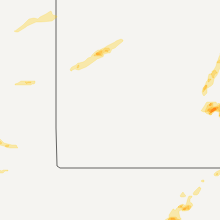
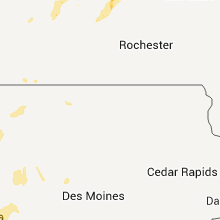
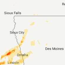
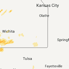
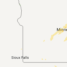
Hail Map for Saturday, May 19, 2012

Number of Impacted Households on 5/19/2012
0
Impacted by 1" or Larger Hail
0
Impacted by 1.75" or Larger Hail
0
Impacted by 2.5" or Larger Hail
Square Miles of Populated Area Impacted on 5/19/2012
0
Impacted by 1" or Larger Hail
0
Impacted by 1.75" or Larger Hail
0
Impacted by 2.5" or Larger Hail


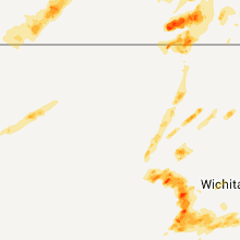

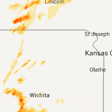


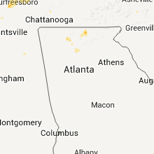

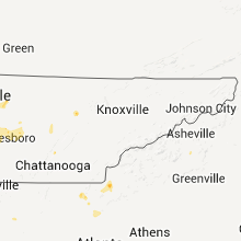


Cities Most Affected by Hail Storms of 5/19/2012
| Hail Size | Demographics of Zip Codes Affected | ||||||
|---|---|---|---|---|---|---|---|
| City | Count | Average | Largest | Pop Density | House Value | Income | Age |
| Arlington, KS | 5 | 1.90 | 2.00 | 4 | $38k | $33.2k | 41.5 |
| Kingman, KS | 3 | 2.17 | 3.00 | 15 | $59k | $39.6k | 42.5 |
| Stafford, KS | 3 | 1.83 | 2.00 | 6 | $25k | $30.5k | 48.4 |
| Elk City, OK | 3 | 1.75 | 1.75 | 77 | $64k | $29.0k | 34.9 |
| Mangum, OK | 2 | 2.13 | 2.50 | 9 | $32k | $24.4k | 42.3 |
| Great Bend, KS | 2 | 2.00 | 2.00 | 78 | $61k | $33.4k | 38.0 |
| Saint John, KS | 1 | 2.50 | 2.50 | 5 | $43k | $33.4k | 45.5 |
| Deweese, NE | 1 | 2.00 | 2.00 | 6 | $22k | $28.1k | 41.5 |
| Turon, KS | 1 | 2.00 | 2.00 | 3 | $31k | $28.1k | 44.3 |
| Sylvia, KS | 1 | 1.75 | 1.75 | 2 | $28k | $31.5k | 47.1 |
| Spivey, KS | 1 | 1.75 | 1.75 | 3 | $31k | $32.8k | 50.4 |
| Nelson, NE | 1 | 1.75 | 1.75 | 4 | $34k | $32.3k | 50.6 |
| Schuyler, NE | 1 | 1.75 | 1.75 | 48 | $66k | $37.7k | 30.1 |
| Olustee, OK | 1 | 1.75 | 1.75 | 2 | $41k | $27.8k | 35.1 |
| Tescott, KS | 1 | 1.75 | 1.75 | 6 | $48k | $41.6k | 43.4 |
| Leedey, OK | 1 | 1.75 | 1.75 | 2 | $26k | $32.1k | 45.3 |
| Murfreesboro, TN | 1 | 1.75 | 1.75 | 348 | $119k | $51.3k | 35.7 |
| Rockvale, TN | 1 | 1.75 | 1.75 | 90 | $114k | $48.3k | 37.4 |
| Saint Paul, MN | 1 | 1.75 | 1.75 | 7260 | $82k | $31.2k | 35.2 |
| Stratton, NE | 1 | 1.75 | 1.75 | 1 | $38k | $26.1k | 50.9 |
| Plevna, KS | 1 | 1.75 | 1.75 | 5 | $45k | $32.8k | 49.1 |
| Benkelman, NE | 1 | 1.75 | 1.75 | 3 | $33k | $26.9k | 46.8 |
| Lebanon, TN | 1 | 1.75 | 1.75 | 253 | $121k | $39.9k | 37.9 |
Hail and Wind Damage Spotted on 5/19/2012
Filter by Report Type:Hail ReportsWind Reports
States Impacted
Nebraska, Colorado, Kansas, Florida, Tennessee, North Carolina, Oklahoma, Minnesota, IowaNebraska
| Local Time | Report Details |
|---|---|
| 9:26 AM CDT | Quarter sized hail reported near Tryon, NE, 37.3 miles NNW of North Platte, NE, ground covered with hail. the largest size if hail was a quarter. |
| 9:26 AM CDT | Quarter sized hail reported near Tryon, NE, 37.3 miles NNW of North Platte, NE, ground covered with hail. the largest size of hail was a quarter. |
| 9:40 AM CDT | Quarter sized hail reported near Seneca, NE, 44.6 miles N of North Platte, NE, nickel to quarter size hail covering the ground. |
| 11:47 AM MDT | Quarter sized hail reported near Benkelman, NE, 52.2 miles NNW of Colby, KS |
| 12:05 PM MDT | Quarter sized hail reported near Max, NE, 56.6 miles NNW of Colby, KS |
| 1:10 PM CDT | Golf Ball sized hail reported near Stratton, NE, 52.9 miles N of Colby, KS |
| 12:15 PM MDT | Golf Ball sized hail reported near Benkelman, NE, 63.8 miles NNW of Colby, KS |
| 1:28 PM CDT | Ping Pong Ball sized hail reported near Palisade, NE, 57.2 miles SSW of North Platte, NE, hail was ping pong ball in size. |
| 1:58 PM CDT | Half Dollar sized hail reported near Hayes Center, NE, 47.5 miles S of North Platte, NE, ground covered white with hail. |
| 2:07 PM CDT | Quarter sized hail reported near Hayes Center, NE, 43.2 miles S of North Platte, NE |
| 2:13 PM CDT | Quarter sized hail reported near Maywood, NE, 40.7 miles S of North Platte, NE, ground is covered white with hail. |
| 2:36 PM CDT | Quarter sized hail reported near Maxwell, NE, 28.7 miles SSE of North Platte, NE, mostly pea to nickel size hail but a few stones were as large as a quarter. |
| 3:08 PM CDT | Ping Pong Ball sized hail reported near Brady, NE, 30.6 miles ESE of North Platte, NE, most of the hail was pea to nickel with a few up to the size of ping pong balls. |
| 4:14 PM CDT | Quarter sized hail reported near Merna, NE, 54.5 miles ENE of North Platte, NE |
| 4:15 PM CDT | Quarter sized hail reported near Blue Hill, NE, 41.4 miles S of Grand Island, NE, nickel to quarter size hail started around 405 pm. |
| 4:18 PM CDT | Quarter sized hail reported near Bladen, NE, 41.9 miles SSW of Grand Island, NE |
| 4:20 PM CDT | Ping Pong Ball sized hail reported near Blue Hill, NE, 41.4 miles S of Grand Island, NE |
| 4:30 PM CDT | Golf Ball sized hail reported near Blue Hill, NE, 41.1 miles S of Grand Island, NE, delayed report from severe storms on the 19th. golf ball size hail for nearly 20 minutes starting around 430 pm. time estimated from radar. severe damage to crops and b |
| 5:05 PM CDT | Hen Egg sized hail reported near Deweese, NE, 38.5 miles SSE of Grand Island, NE, hail up to the size of hen eggs reported. trees damaged. |
| 5:12 PM CDT | Quarter sized hail reported near Fairfield, NE, 37 miles SSE of Grand Island, NE, dime to quarter size hail reported. |
| 5:12 PM CDT | Wind gust measured at intersection of highways 14 and 4 in northern nuckolls count in nuckolls county NE, 44.4 miles SSE of Grand Island, NE |
| 5:16 PM CDT | Golf Ball sized hail reported near Nelson, NE, 41 miles SSE of Grand Island, NE, quarter to golf ball hail almost covering ground |
| 5:24 PM CDT | At least 3 fields located approximately 1 mile west of the deweese spur off of highway 14 and 1 mile north of the county line were damaged. time estimated from rada in clay county NE, 40.2 miles SSE of Grand Island, NE |
| 5:30 PM CDT | Quarter sized hail reported near Bradshaw, NE, 31 miles E of Grand Island, NE, hail sized from pea to slightly larger than a quarter. covered most of the ground |
| 5:40 PM CDT | Quarter sized hail reported near Shelby, NE, 57.1 miles ENE of Grand Island, NE, delayed report from severe storms on the 19th. hail up to quarter size. time estimated from radar data. report from nerain observer. |
| 5:44 PM CDT | Quarter sized hail reported near Superior, NE, 64 miles SSE of Grand Island, NE |
| 5:48 PM CDT | Pivot overturned near highway 8 on the east side of hardy. tree limbs 2 inches in diameter snapped in hardy. time estimated from rada in nuckolls county NE, 66.9 miles SSE of Grand Island, NE |
| 5:50 PM CDT | Ping Pong Ball sized hail reported near Superior, NE, 64 miles SSE of Grand Island, NE |
| 5:57 PM CDT | 8-10 power poles down from hardy to sw of ruskin. pivots knocked over als in nuckolls county NE, 59.5 miles SSE of Grand Island, NE |
| 6:02 PM CDT | Power lines down south of ruski in nuckolls county NE, 64.6 miles SSE of Grand Island, NE |
| 6:03 PM CDT | Quarter sized hail reported near Clay Center, NE, 39 miles SE of Grand Island, NE, quarter size hail at intersection of cr 309 and cr w |
| 6:11 PM CDT | Quarter sized hail reported near Omaha, NE, 7.4 miles NW of Omaha, NE |
| 6:15 PM CDT | Wind gust reported at the airport 36006g57kt in york county NE, 37.7 miles E of Grand Island, NE |
| 6:20 PM CDT | Quarter sized hail reported near Malcolm, NE, 52.2 miles WSW of Omaha, NE |
| 6:20 PM CDT | A grain bin was reported in the southbound lanes of highway 81 near strang between roads s and t. time estimated from rada in fillmore county NE, 52.6 miles SE of Grand Island, NE |
| 6:22 PM CDT | Quarter sized hail reported near Schuyler, NE, 59.4 miles WNW of Omaha, NE |
| 6:22 PM CDT | Quarter sized hail reported near Doniphan, NE, 8.7 miles S of Grand Island, NE, just south of i-80 |
| 6:28 PM CDT | Quarter sized hail reported near Raymond, NE, 51.7 miles WSW of Omaha, NE |
| 6:28 PM CDT | Quarter and golfball hai in colfax county NE, 59.7 miles WNW of Omaha, NE |
| 6:35 PM CDT | Golf Ball sized hail reported near Schuyler, NE, 58.6 miles WNW of Omaha, NE |
| 6:44 PM CDT | Quarter sized hail reported near Grand Island, NE, 1.6 miles WSW of Grand Island, NE |
| 6:47 PM CDT | Ping Pong Ball sized hail reported near Doniphan, NE, 6 miles SSE of Grand Island, NE, hail reported near highways 2 and 34. |
| 6:50 PM CDT | Quarter sized hail reported near Grand Island, NE, 3.1 miles WSW of Grand Island, NE |
| 6:55 PM CDT | Quarter sized hail reported near Brainard, NE, 53.7 miles W of Omaha, NE |
| 7:00 PM CDT | Quarter sized hail reported near North Bend, NE, 46 miles WNW of Omaha, NE |
| 7:38 PM CDT | Nickle size hai in saunders county NE, 39.5 miles WSW of Omaha, NE |
| 7:41 PM CDT | Storm damage reported in saunders county NE, 35.5 miles W of Omaha, NE |
| 7:45 PM CDT | 3-5 inch diameter tree branches broke in saunders county NE, 36.1 miles WNW of Omaha, NE |
| 7:53 PM CDT | Storm damage reported in saunders county NE, 27.1 miles SW of Omaha, NE |
| 7:55 PM CDT | Barn roof blown off in washington county NE, 21.4 miles NNW of Omaha, NE |
| 7:55 PM CDT | 6 inch diameter tree uprooted. wind equipment measured 58 mph gus in washington county NE, 15.1 miles NNW of Omaha, NE |
| 8:00 PM CDT | Measured by public with wind equipment. horse barn destroyed and siding damage to hous in washington county NE, 22.9 miles NNW of Omaha, NE |
| 8:10 PM CDT | Tree and power lines down near dodge park along north 36th s in douglas county NE, 3.6 miles W of Omaha, NE |
| 8:11 PM CDT | Quarter sized hail reported near Omaha, NE, 7.4 miles NW of Omaha, NE |
| 9:36 PM CDT | Quarter sized hail reported near Louisville, NE, 18.6 miles SSW of Omaha, NE |
Colorado
| Local Time | Report Details |
|---|---|
| 10:02 AM MDT | Quarter sized hail reported near Eads, CO, 103.9 miles E of Pueblo, CO, significant accumulation on the ground. |
| 2:17 PM MDT | Quarter sized hail reported near Model, CO, 54.2 miles SSE of Pueblo, CO, fell for 9 minutes. |
| 5:47 PM MDT | Quarter sized hail reported near Westcliffe, CO, 37.1 miles W of Pueblo, CO |
Kansas
| Local Time | Report Details |
|---|---|
| 1:46 PM CDT | Quarter sized hail reported near Winona, KS, 35 miles SSW of Colby, KS, chaser reports large quantity of hail covering highway 25 at russell springs |
| 3:35 PM CDT | Hen Egg sized hail reported near Great Bend, KS, 43.9 miles SE of Hays, KS |
| 3:36 PM CDT | Quarter sized hail reported near St John, KS, 65.5 miles SSE of Hays, KS |
| 3:38 PM CDT | Quarter sized hail reported near Great Bend, KS, 45.2 miles SE of Hays, KS |
| 3:42 PM CDT | Quarter sized hail reported near Great Bend, KS, 45.2 miles SE of Hays, KS |
| 3:45 PM CDT | Hen Egg sized hail reported near Great Bend, KS, 45.2 miles SE of Hays, KS |
| 3:50 PM CDT | Tennis Ball sized hail reported near St John, KS, 71.3 miles SSE of Hays, KS |
| 3:59 PM CDT | Quarter sized hail reported near St John, KS, 74.5 miles SSE of Hays, KS |
| 4:05 PM CDT | Quarter sized hail reported near Stafford, KS, 70.6 miles SSE of Hays, KS |
| 4:07 PM CDT | Ping Pong Ball sized hail reported near Stafford, KS, 71.4 miles SE of Hays, KS |
| 4:15 PM CDT | Ping Pong Ball sized hail reported near Jewell, KS, 84 miles NE of Hays, KS, half dollar sized hail...just hail no wind or rain |
| 4:22 PM CDT | Quarter sized hail reported near Stafford, KS, 65.2 miles WNW of Wichita, KS |
| 4:22 PM CDT | Quarter sized hail reported near Stafford, KS, 68 miles WNW of Wichita, KS |
| 4:23 PM CDT | Golf Ball sized hail reported near Stafford, KS, 65.2 miles WNW of Wichita, KS |
| 4:27 PM CDT | Hen Egg sized hail reported near Stafford, KS, 68.5 miles WNW of Wichita, KS, this time was estimated by radar data. |
| 4:31 PM CDT | Golf Ball sized hail reported near Stafford, KS, 67.1 miles WNW of Wichita, KS |
| 4:44 PM CDT | Golf Ball sized hail reported near Sylvia, KS, 61.7 miles WNW of Wichita, KS |
| 4:45 PM CDT | Ping Pong Ball sized hail reported near Sylvan Grove, KS, 54.3 miles E of Hays, KS |
| 4:45 PM CDT | Storm damage reported in lincoln county KS, 54.3 miles E of Hays, KS |
| 5:00 PM CDT | Ping Pong Ball sized hail reported near Sylvia, KS, 61.1 miles WNW of Wichita, KS, public reported ping pong ball size hail covering his yard. |
| 5:06 PM CDT | Half Dollar sized hail reported near Sylvia, KS, 60.6 miles WNW of Wichita, KS |
| 5:11 PM CDT | Golf Ball sized hail reported near Plevna, KS, 53.2 miles WNW of Wichita, KS |
| 5:11 PM CDT | Hen Egg sized hail reported near Turon, KS, 52.2 miles WNW of Wichita, KS |
| 5:15 PM CDT | Quarter sized hail reported near Arlington, KS, 48.5 miles WNW of Wichita, KS |
| 5:15 PM CDT | Quarter sized hail reported near Ellsworth, KS, 60.2 miles E of Hays, KS |
| 5:17 PM CDT | Hen Egg sized hail reported near Arlington, KS, 48.8 miles WNW of Wichita, KS |
| 5:18 PM CDT | Ping Pong Ball sized hail reported near Ellsworth, KS, 60.2 miles E of Hays, KS |
| 5:18 PM CDT | Golf Ball sized hail reported near Arlington, KS, 50.4 miles WNW of Wichita, KS |
| 5:21 PM CDT | Golf Ball sized hail reported near Arlington, KS, 48.5 miles WNW of Wichita, KS |
| 5:24 PM CDT | Hen Egg sized hail reported near Arlington, KS, 49.2 miles WNW of Wichita, KS |
| 5:30 PM CDT | Ping Pong Ball sized hail reported near Jewell, KS, 84 miles NE of Hays, KS, hail up to the size of ping pong balls reported. |
| 5:30 PM CDT | Hen Egg sized hail reported near Arlington, KS, 48.8 miles WNW of Wichita, KS |
| 5:35 PM CDT | Quarter sized hail reported near Hutchinson, KS, 35.9 miles WNW of Wichita, KS |
| 5:44 PM CDT | Golf Ball sized hail reported near Kingman, KS, 48 miles W of Wichita, KS |
| 5:57 PM CDT | Golf Ball sized hail reported near Kingman, KS, 42.5 miles W of Wichita, KS |
| 6:03 PM CDT | Tea Cup sized hail reported near Kingman, KS, 38.6 miles W of Wichita, KS |
| 6:04 PM CDT | Estimating 65 to 70 mph wind in kingman county KS, 48.4 miles WSW of Wichita, KS |
| 6:06 PM CDT | Tea Cup sized hail reported near Kingman, KS, 38.1 miles W of Wichita, KS |
| 6:20 PM CDT | Golf Ball sized hail reported near Tescott, KS, 71.9 miles WSW of Manhattan, KS |
| 6:23 PM CDT | Quarter sized hail reported near Sterling, KS, 61.1 miles NW of Wichita, KS |
| 6:27 PM CDT | Golf Ball sized hail reported near Spivey, KS, 44.3 miles WSW of Wichita, KS, pea to golfball size hail for 3 to 4 minutes. |
| 6:35 PM CDT | Half Dollar sized hail reported near Tescott, KS, 68.9 miles W of Manhattan, KS |
| 6:49 PM CDT | Half Dollar sized hail reported near Attica, KS, 59.3 miles WSW of Wichita, KS, correction. location is wnw not wsw. |
| 6:49 PM CDT | Half Dollar sized hail reported near Waldron, KS, 65.5 miles SW of Wichita, KS |
| 6:52 PM CDT | Ping Pong Ball sized hail reported near Attica, KS, 59.3 miles WSW of Wichita, KS |
| 6:52 PM CDT | Ping Pong Ball sized hail reported near Waldron, KS, 65.5 miles SW of Wichita, KS |
| 7:32 PM CDT | Ping Pong Ball sized hail reported near Danville, KS, 40.2 miles SW of Wichita, KS |
| 7:35 PM CDT | Golf Ball sized hail reported near Solomon, KS, 50.6 miles WSW of Manhattan, KS |
| 8:00 PM CDT | Quarter sized hail reported near Abilene, KS, 39.2 miles WSW of Manhattan, KS |
| 8:26 PM CDT | Half Dollar sized hail reported near Mulvane, KS, 15.2 miles SSE of Wichita, KS |
| 8:30 PM CDT | Storm damage reported in sedgwick county KS, 5.9 miles SE of Wichita, KS |
| 9:47 PM CDT | Spotters reported 70 to 80 mph winds near eureka city lake with numerous trees dow in greenwood county KS, 47.7 miles WNW of Chanute, KS |
| 9:48 PM CDT | Quarter sized hail reported near Winfield, KS, 35.1 miles SE of Wichita, KS, nickel to quarter size hail. |
| 9:57 PM CDT | Quarter sized hail reported near Severy, KS, 42.9 miles W of Chanute, KS |
Florida
| Local Time | Report Details |
|---|---|
| 3:20 PM EDT | Quarter sized hail reported near Stuart, FL, 13.5 miles SSE of Port Saint Lucie, FL, lasted for about 15 minutes |
| 3:50 PM EDT | Quarter sized hail reported near Stuart, FL, 12.4 miles SSE of Port Saint Lucie, FL, skywarn spotter in southwest stuart measured one inch hail and wind gust to 34 mph. |
| 3:50 PM EDT | Quarter sized hail reported near Palm City, FL, 9.2 miles SE of Port Saint Lucie, FL, skywarn spotter in palm city reported quarter size hail from 350 pm to 4 pm. |
| 3:55 PM EDT | Quarter sized hail reported near Palm City, FL, 7.3 miles SE of Port Saint Lucie, FL, skywarn spotter in palm city observed nickel to quarter size hail. |
Tennessee
| Local Time | Report Details |
|---|---|
| 2:30 PM CDT | Quarter sized hail reported near Pikeville, TN, 35.5 miles N of Chattanooga, TN |
| 3:10 PM CDT | Quarter sized hail reported near Pikeville, TN, 36.5 miles N of Chattanooga, TN |
| 4:23 PM CDT | Quarter sized hail reported near Springfield, TN, 23.6 miles NNW of Nashville, TN |
| 4:25 PM CDT | Public reported home weather station near beechgrove measured a wind gust of 64 mp in coffee county TN, 47.8 miles SE of Nashville, TN |
| 4:40 PM CDT | Quarter sized hail reported near Beech Grove, TN, 47.8 miles SE of Nashville, TN, reported near beechgrove via facebook. time estimated. |
| 5:01 PM CDT | Quarter sized hail reported near Murfreesboro, TN, 30.9 miles SE of Nashville, TN, numerous reports of nickel to quarter size hail along old fort pkwy |
| 5:23 PM CDT | Golf Ball sized hail reported near Murfreesboro, TN, 32.9 miles SE of Nashville, TN, blackmon area up to golf ball size |
| 5:23 PM CDT | Golf Ball sized hail reported near Rockvale, TN, 30.4 miles SSE of Nashville, TN, spotter reported up to golf ball size hail in blackman. corrected lat/lon location. |
| 5:30 PM CDT | Public reported via facebook a few trees blown down at old fort parkway and chaffin place in murfreesboro. time estimate in rutherford county TN, 29.3 miles SE of Nashville, TN |
| 5:47 PM CDT | Half Dollar sized hail reported near Unionville, TN, 39.2 miles SSE of Nashville, TN, up to half dollar size hail covering the ground in unionville |
| 6:00 PM CDT | Golf Ball sized hail reported near Lebanon, TN, 25.8 miles E of Nashville, TN, in the city of lebanon. |
| 6:09 PM CDT | Quarter sized hail reported near Lebanon, TN, 25.9 miles E of Nashville, TN, hailed for 10 minutes |
| 6:40 PM CDT | Quarter sized hail reported near Nolensville, TN, 16.6 miles SSE of Nashville, TN |
| 6:54 PM CDT | Tree blown down in east brentwood in davidson county TN, 11.2 miles SSE of Nashville, TN |
North Carolina
| Local Time | Report Details |
|---|---|
| 5:42 PM EDT | Quarter sized hail reported near Arden, NC, 42.1 miles N of Greenville, SC, hail ranging in size up to a quarter fell at the asheville regional airport. there were two periods of hail in the storm and hail partially covered the ground during a |
Oklahoma
| Local Time | Report Details |
|---|---|
| 5:28 PM CDT | Quarter sized hail reported near Sharon, OK, 11.1 miles SSE of Woodward, OK |
| 5:50 PM CDT | Quarter sized hail reported near Leedey, OK, 32.8 miles S of Woodward, OK |
| 6:19 PM CDT | Golf Ball sized hail reported near Leedey, OK, 35.5 miles S of Woodward, OK |
| 6:48 PM CDT | Quarter sized hail reported near Leedey, OK, 33.1 miles S of Woodward, OK |
| 7:34 PM CDT | Quarter sized hail reported near Sayre, OK, 68 miles SSW of Woodward, OK, quarter size hail fell for at least 2 minutes |
| 7:48 PM CDT | Quarter sized hail reported near Sharon, OK, 16.6 miles SSE of Woodward, OK |
| 7:55 PM CDT | Golf Ball sized hail reported near Elk City, OK, 67.1 miles S of Woodward, OK |
| 8:36 PM CDT | Quarter sized hail reported near Butler, OK, 63.4 miles S of Woodward, OK |
| 8:50 PM CDT | Golf Ball sized hail reported near Elk City, OK, 71.3 miles S of Woodward, OK |
| 8:50 PM CDT | Baseball sized hail reported near Elk City, OK, 74 miles S of Woodward, OK |
| 9:01 PM CDT | Half Dollar sized hail reported near Elk City, OK, 71.3 miles S of Woodward, OK, large amounts on ground |
| 9:10 PM CDT | Golf Ball sized hail reported near Elk City, OK, 71.8 miles NE of Childress, TX, just east of the jct of hwy 34 and 152 |
| 9:29 PM CDT | Quarter sized hail reported near Willow, OK, 60 miles NE of Childress, TX |
| 10:45 PM CDT | Quarter sized hail reported near Mangum, OK, 51 miles NE of Childress, TX |
| 10:47 PM CDT | Tennis Ball sized hail reported near Mangum, OK, 50.6 miles NE of Childress, TX, numerous on the ground |
| 10:49 PM CDT | Golf Ball sized hail reported near Mangum, OK, 51 miles NE of Childress, TX |
| 10:50 PM CDT | Storm damage reported in kiowa county OK, 77 miles ENE of Childress, TX |
| 11:45 PM CDT | Golf Ball sized hail reported near Olustee, OK, 46.3 miles ENE of Childress, TX |
| 11:59 PM CDT | Quarter sized hail reported near Altus, OK, 52.3 miles ENE of Childress, TX |
| 12:05 AM CDT | Quarter sized hail reported near Altus, OK, 54.9 miles ENE of Childress, TX |
| 12:05 AM CDT | Quarter sized hail reported near Altus, OK, 54 miles ENE of Childress, TX |
| 12:07 AM CDT | Storm damage reported in jackson county OK, 54.9 miles ENE of Childress, TX |
| 12:21 AM CDT | Quarter sized hail reported near Cordell, OK, 81.6 miles SSE of Woodward, OK |
| 12:25 AM CDT | Storm damage reported in grady county OK, 27.8 miles WSW of Oklahoma City, OK |
| 1:03 AM CDT | Storm damage reported in oklahoma county OK, 7.2 miles SW of Oklahoma City, OK |
| 1:10 AM CDT | Winds estimated near 60 mph along i-35 between sw 134th and 89th street. small tree limbs dow in cleveland county OK, 9.3 miles S of Oklahoma City, OK |
| 1:20 AM CDT | Half Dollar sized hail reported near Sentinel, OK, 86 miles NE of Childress, TX |
| 1:40 AM CDT | Storm damage reported in cleveland county OK, 26.8 miles SE of Oklahoma City, OK |
| 3:20 AM CDT | Quarter sized hail reported near Elmore City, OK, 57.8 miles S of Oklahoma City, OK |
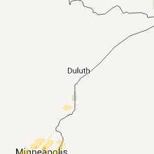
Minnesota
| Local Time | Report Details |
|---|---|
| 6:00 PM CDT | Large tree uprooted in mcleod county MN, 38.5 miles W of Minneapolis, MN |
| 6:27 PM CDT | Quarter sized hail reported near Minneapolis, MN, 6.9 miles S of Minneapolis, MN |
| 6:30 PM CDT | Near st. thomas univ. 10 cottonwood tree limb down in ramsey county MN, 8.3 miles ESE of Minneapolis, MN |
| 7:15 PM CDT | Quarter sized hail reported near Shakopee, MN, 19.1 miles SW of Minneapolis, MN |
| 7:23 PM CDT | Quarter sized hail reported near Bloomington, MN, 10.6 miles SSW of Minneapolis, MN |
| 7:23 PM CDT | Quarter sized hail reported near Burnsville, MN, 13.1 miles S of Minneapolis, MN |
| 7:34 PM CDT | Quarter sized hail reported near St Paul, MN, 6.9 miles SE of Minneapolis, MN |
| 7:35 PM CDT | Golf Ball sized hail reported near St Paul, MN, 8.3 miles ESE of Minneapolis, MN, western st. paul |
| 8:00 PM CDT | Quarter sized hail reported near St Paul, MN, 16.1 miles SSE of Minneapolis, MN |
| 8:00 PM CDT | Quarter sized hail reported near St Paul, MN, 11.4 miles SSE of Minneapolis, MN |
| 8:07 PM CDT | Quarter sized hail reported near St Paul, MN, 16.1 miles SSE of Minneapolis, MN |
| 8:07 PM CDT | Quarter sized hail reported near Burnsville, MN, 13.1 miles S of Minneapolis, MN |
| 8:15 PM CDT | Two 12 inch diameter trees down near intersection of se elm street and se kasota ave. approximate tim in hennepin county MN, 1.3 miles S of Minneapolis, MN |
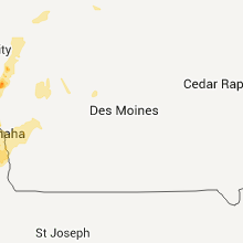
Iowa
| Local Time | Report Details |
|---|---|
| 7:05 PM CDT | Quarter sized hail reported near Onawa, IA, 53.7 miles N of Omaha, NE |
| 7:25 PM CDT | Quarter sized hail reported near Onawa, IA, 54.3 miles N of Omaha, NE |
| 8:00 PM CDT | Quarter sized hail reported near Anthon, IA, 42 miles WSW of Storm Lake, IA, mostly small hail...but a few stones to size of quarters |
| 8:15 PM CDT | Tree limbs and one power pole down in modale. delayed report. time estimate in harrison county IA, 25.1 miles N of Omaha, NE |
| 8:20 PM CDT | Gusts estimated 70mph. gas station signs blown dow in pottawattamie county IA, 4.4 miles ESE of Omaha, NE |
| 8:21 PM CDT | Quarter sized hail reported near Missouri Valley, IA, 20.8 miles N of Omaha, NE, estimated wind gust to 45mph with small tree limbs down. |
| 8:36 PM CDT | Several trees and an old barn blown over at the intersection of 140th street and q avenue. time estimated from rada in crawford county IA, 50.4 miles SSW of Storm Lake, IA |
| 8:38 PM CDT | Storm damage reported in crawford county IA, 47 miles NNE of Omaha, NE |
| 8:40 PM CDT | Storm damage reported in crawford county IA, 46.2 miles NNE of Omaha, NE |
| 8:50 PM CDT | Power out in tow in crawford county IA, 35.6 miles SSW of Storm Lake, IA |
| 8:50 PM CDT | Power out and branches down in town. trampoline wrapped around a tree. time estimated from rada in crawford county IA, 40.4 miles SSW of Storm Lake, IA |
| 8:51 PM CDT | Storm damage reported in crawford county IA, 44 miles S of Storm Lake, IA |
| 9:06 PM CDT | Wind speed estimated. tree damage...extent unknow in woodbury county IA, 35.8 miles WSW of Storm Lake, IA |
| 9:10 PM CDT | Several large trees knocked down in a cemetary. winds estimated at 60 mp in sac county IA, 23.4 miles S of Storm Lake, IA |
| 9:14 PM CDT | Spotter estimated wind gusts near 60 mph for about 5 minute in carroll county IA, 34.2 miles SSE of Storm Lake, IA |
| 9:20 PM CDT | Damaging winds estimated at 60 mph knocked the power out. the spotter heard something bang against the in woodbury county IA, 34.9 miles WSW of Storm Lake, IA |
| 9:20 PM CDT | Barn blown into the road in woodbury county IA, 33.6 miles WSW of Storm Lake, IA |
| 9:20 PM CDT | Quarter sized hail reported near Correctionville, IA, 34.9 miles WSW of Storm Lake, IA, in addition to the hail,the rain was so heavy the spotter could hardly see out the window. |
| 9:21 PM CDT | 2 reports of trees down on houses in tow in woodbury county IA, 31.7 miles WSW of Storm Lake, IA |
| 9:30 PM CDT | Trees down in wasta. wind gusts estimated at 60 mp in cherokee county IA, 26.8 miles W of Storm Lake, IA |
| 9:32 PM CDT | The top of the spotters tree was re in cherokee county IA, 22.9 miles W of Storm Lake, IA |
| 9:55 PM CDT | Trees down in marcus. wind gusts estimated at 60 mp in cherokee county IA, 33.2 miles WNW of Storm Lake, IA |
Connect with Interactive Hail Maps