

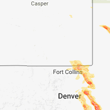
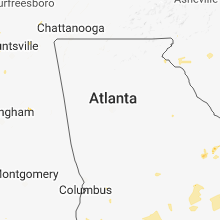
Hail Map for Monday, August 6, 2018

Number of Impacted Households on 8/6/2018
0
Impacted by 1" or Larger Hail
0
Impacted by 1.75" or Larger Hail
0
Impacted by 2.5" or Larger Hail
Square Miles of Populated Area Impacted on 8/6/2018
0
Impacted by 1" or Larger Hail
0
Impacted by 1.75" or Larger Hail
0
Impacted by 2.5" or Larger Hail


Cities Most Affected by Hail Storms of 8/6/2018
| Hail Size | Demographics of Zip Codes Affected | ||||||
|---|---|---|---|---|---|---|---|
| City | Count | Average | Largest | Pop Density | House Value | Income | Age |
| Colorado Springs, CO | 9 | 2.53 | 4.00 | 271 | $153k | $44.7k | 37.6 |
| Grant, NE | 5 | 2.90 | 4.25 | 1 | $62k | $34.1k | 44.7 |
| Oshkosh, NE | 3 | 1.83 | 2.00 | 1 | $44k | $27.8k | 49.3 |
| Cheyenne, WY | 3 | 1.83 | 2.00 | 100 | $82k | $31.0k | 32.6 |
| Angora, NE | 2 | 2.75 | 3.00 | 1 | $48k | $28.9k | 49.8 |
| Lisco, NE | 2 | 2.25 | 2.75 | 0 | $59k | $29.3k | 45.4 |
| Briggsdale, CO | 2 | 2.25 | 2.75 | 2 | $117k | $46.1k | 40.9 |
| Fountain, CO | 2 | 2.13 | 2.50 | 421 | $118k | $42.2k | 29.0 |
| Wiggins, CO | 2 | 1.88 | 2.00 | 10 | $108k | $36.4k | 37.5 |
| Big Springs, NE | 1 | 3.00 | 3.00 | 2 | $47k | $29.3k | 49.5 |
| Boone, CO | 1 | 2.50 | 2.50 | 1 | $65k | $26.4k | 45.8 |
| Harrison, NE | 1 | 2.50 | 2.50 | 0 | $37k | $28.2k | 49.9 |
| Grover, CO | 1 | 2.00 | 2.00 | 0 | $74k | $22.7k | 47.9 |
| Lewellen, NE | 1 | 1.75 | 1.75 | 1 | $61k | $26.3k | 56.7 |
| Alda, NE | 1 | 1.75 | 1.75 | 45 | $71k | $36.2k | 34.0 |
| Benedict, NE | 1 | 1.75 | 1.75 | 5 | $60k | $42.2k | 45.9 |
| Hugo, CO | 1 | 1.75 | 1.75 | 0 | $71k | $31.3k | 46.8 |
| Waco, NE | 1 | 1.75 | 1.75 | 8 | $56k | $37.7k | 49.4 |
| Avondale, CO | 1 | 1.75 | 1.75 | 2 | $67k | $33.8k | 39.8 |
| Kennebec, SD | 1 | 1.75 | 1.75 | 0 | $42k | $37.8k | 44.6 |
| Brule, NE | 1 | 1.75 | 1.75 | 2 | $52k | $27.0k | 51.6 |
| Limon, CO | 1 | 1.75 | 1.75 | 2 | $88k | $35.1k | 38.2 |
| Archer, NE | 1 | 1.75 | 1.75 | 5 | $60k | $41.1k | 39.0 |
Hail and Wind Damage Spotted on 8/6/2018
Filter by Report Type:Hail ReportsWind Reports
States Impacted
Wyoming, Michigan, South Carolina, Mississippi, Virginia, North Carolina, Arkansas, New York, Colorado, Ohio, Alabama, Georgia, Florida, South Dakota, Nebraska, Illinois, Indiana, Minnesota, Kansas, Missouri, Iowa, Vermont, LouisianaWyoming
| Local Time | Report Details |
|---|---|
| 10:16 AM MDT | Quarter sized hail reported near Cheyenne, WY, 43.7 miles ESE of Laramie, WY |
| 10:16 AM MDT | Ping Pong Ball sized hail reported near Cheyenne, WY, 43.7 miles ESE of Laramie, WY |
| 10:16 AM MDT | Golf Ball sized hail reported near Cheyenne, WY, 44.9 miles ESE of Laramie, WY |
| 2:02 PM MDT | Quarter sized hail reported near Cheyenne, WY, 41.9 miles ESE of Laramie, WY, nws employee report nickle to quarter sized hail |
| 2:05 PM MDT | Quarter sized hail reported near Cheyenne, WY, 44.2 miles ESE of Laramie, WY, quarter size hail in south greeley. |
| 2:05 PM MDT | Quarter sized hail reported near Cheyenne, WY, 45.9 miles ESE of Laramie, WY, quarter size hail at fox farm in cheyenne. |
| 2:15 PM MDT | Quarter sized hail reported near Cheyenne, WY, 43.7 miles ESE of Laramie, WY |
| 2:18 PM MDT | Quarter sized hail reported near Cheyenne, WY, 45 miles ESE of Laramie, WY, quarter size hail falling on the 700 block of college drive. |
| 2:18 PM MDT | Golf Ball sized hail reported near Cheyenne, WY, 44.4 miles ESE of Laramie, WY, golf ball size hail reported in orchard valley... cheyenne. |
| 2:19 PM MDT | Hen Egg sized hail reported near Cheyenne, WY, 43.7 miles ESE of Laramie, WY, this was reported willow pond country homes. |
Michigan
| Local Time | Report Details |
|---|---|
| 1:35 PM EDT | Several reports of trees or wires down throughout the county but no concentrated area affected. scattered power outages across the count in calhoun county MI, 51.6 miles SE of Grand Rapids, MI |
| 2:00 PM EDT | Several 6 inch tree limbs down... some blocking a road. corn blown dow in calhoun county MI, 66.1 miles SSE of Grand Rapids, MI |
| 2:35 PM EDT | 3 trees down in spring arbor and 1 in concord requiring police/road crew respons in jackson county MI, 71.2 miles SW of Flint, MI |
| 3:15 PM EDT | Picture of partially downed tree at belle isle par in wayne county MI, 58.3 miles SE of Flint, MI |
| 3:21 PM EDT | Picture of downed tree at grosse pointe public librar in wayne county MI, 58.6 miles SE of Flint, MI |
| 3:24 PM EDT | Gust measured at peche island lighthouse in lcz460 county MI, 59.8 miles SE of Flint, MI |
| 6:02 PM EDT | Two large trees tipped over. time estimated by rada in st. joseph county MI, 60.9 miles N of Fort Wayne, IN |
South Carolina
| Local Time | Report Details |
|---|---|
| 2:29 PM EDT | Aiken emergency manager reported that the steeple from langley first baptist church had been blown off the churc in aiken county SC, 7.8 miles ENE of Augusta, GA |
| 3:10 PM EDT | Barnwell dispatch reported powerlines down on hwy 278 near hwy 3 in barnwell county SC, 29.8 miles ESE of Augusta, GA |
| 3:52 PM EDT | Report of power line down on sunrise drive. time estimated by rada in oconee county SC, 20.7 miles W of Greenville, SC |
| 4:20 PM EDT | The allendale county warning point reported a tree down on a power line along highway 27 in allendale county SC, 50.3 miles SE of Augusta, GA |
| 4:23 PM EDT | The allendale county warning point reported a tree down near fairfa in allendale county SC, 55.6 miles SE of Augusta, GA |
| 4:38 PM EDT | The south carolina highway patrol reported a tree down along williams stree in hampton county SC, 58.8 miles N of Savannah, GA |
| 4:50 PM EDT | South carolina highway patrol reported a tree down at old salkehatchie highway and cope creek roa in hampton county SC, 61.7 miles ESE of Augusta, GA |
| 4:51 PM EDT | South carolina highway patrol reported a tree down on bamberg highway before old salkehatchie highwa in hampton county SC, 60.6 miles N of Savannah, GA |
| 4:51 PM EDT | Report of a few large trees uprooted on pickens r in oconee county SC, 33.1 miles WSW of Greenville, SC |
| 5:03 PM EDT | Hampton county dispatch reported trees and power lines down on lento road near the intersection with speed limit roa in hampton county SC, 46.8 miles N of Savannah, GA |
| 5:03 PM EDT | South carolina highway patrol reported a tree down on cypress branch road near the intersection with gillison branch road. the damage was due to thunderstorm outflo in jasper county SC, 36 miles N of Savannah, GA |
| 5:08 PM EDT | Report of tree down on roadway near intersection of tate chapman rd and jonesville rd. time estimated by rada in greenville county SC, 20.5 miles ESE of Greenville, SC |
| 5:12 PM EDT | Report of multiple large trees uprooted and a few snapped trees on hartwick ln. time estimated by rada in greenville county SC, 22.8 miles ESE of Greenville, SC |
| 5:12 PM EDT | Report of trees down on interstate 85 near mile marker 10. time estimated by rada in anderson county SC, 26.7 miles SW of Greenville, SC |
| 5:19 PM EDT | South carolina highway patrol reported a tree down on old salkehatchie highway between ram horn road and anna laurel roa in hampton county SC, 50.8 miles NNE of Savannah, GA |
| 5:20 PM EDT | Report of tree down near the intersection of milford rd and hwy 243. time estimated by rada in anderson county SC, 25.8 miles SW of Greenville, SC |
| 5:33 PM EDT | Quarter sized hail reported near Simpsonville, SC, 20.6 miles ESE of Greenville, SC |
| 5:34 PM EDT | The south carolina highway patrol reported a tree down near the intersection of black creek road and highway 2 in colleton county SC, 51.5 miles NNE of Savannah, GA |
| 5:35 PM EDT | Tree down on hwy 61 near i-95. time estimated by rada in colleton county SC, 38.2 miles W of Charleston, SC |
| 5:38 PM EDT | Report of tree down near intersection of johnson lake drive and diamond d club r in spartanburg county SC, 44.6 miles E of Greenville, SC |
| 5:40 PM EDT | South carolina highway patrol reported a tree down along i-95 between mile marker 40 and 4 in colleton county SC, 47.7 miles NNE of Savannah, GA |
| 5:40 PM EDT | South carolina highway patrol reported a tree down on beech hill road near mossy rock crossin in dorchester county SC, 21.2 miles SW of Charleston, SC |
Mississippi
| Local Time | Report Details |
|---|---|
| 1:34 PM CDT | Quarter sized hail reported near Maben, MS, 14.5 miles W of Starkville, MS |
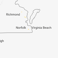
Virginia
| Local Time | Report Details |
|---|---|
| 2:35 PM EDT | Trees reported down in the great bridge are in city of chesapeake county VA, 9.5 miles WSW of Virginia Beach, VA |
| 4:00 PM EDT | Quarter sized hail reported near Floyd, VA, 36.4 miles SW of Roanoke, VA, dime to quarter size hail near the tuggle gap entrance to the blue ridge parkway. time estimated from radar. |
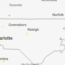
North Carolina
| Local Time | Report Details |
|---|---|
| 2:48 PM EDT | Surry county 911 dispatch reported a tree down on the 2200 block of pipers gap road in mount airy. time estimate in surry county NC, 65.2 miles SW of Roanoke, VA |
| 4:10 PM EDT | Report of trees down on interstate 40 near exit 132 closing westbound lane in catawba county NC, 39.9 miles NNW of Charlotte, NC |
| 4:10 PM EDT | Tree down on mobile home on county home roa in catawba county NC, 41.7 miles NNW of Charlotte, NC |
| 4:18 PM EDT | Fire department dispatched to remove two downed trees from the intersection of highway 210 and berea church road. time estimated from rada in johnston county NC, 20 miles SSE of Raleigh, NC |
| 4:36 PM EDT | Powerlines down. time estimated by rada in johnston county NC, 23.4 miles E of Raleigh, NC |
| 5:05 PM EDT | 1 tree down on highway 42 between siler city glendon road and walter oldham road. time estimated by rada in chatham county NC, 49 miles WSW of Raleigh, NC |
| 5:15 PM EDT | Tree down on siler city glendon road... south of tyson creek church roa in chatham county NC, 48.5 miles WSW of Raleigh, NC |
| 6:30 PM EDT | Tree down on moncure school roa in chatham county NC, 26.8 miles WSW of Raleigh, NC |
Arkansas
| Local Time | Report Details |
|---|---|
| 2:15 PM CDT | Several trees down north of pocahontas. thomasville and olive rd for main area of damag in randolph county AR, 92.4 miles NNW of Memphis, TN |
| 2:23 PM CDT | Power lines were blown down. trees were blown down on houses. roofs were damage in jackson county AR, 76.3 miles WNW of Memphis, TN |
| 2:45 PM CDT | Aluminum roof blown off of aid building on commerce drive behind walmar in randolph county AR, 92.4 miles NNW of Memphis, TN |
| 2:50 PM CDT | A power line was blown down. some large limbs were blown down as wel in white county AR, 28.1 miles NNE of Little Rock, AR |
| 3:55 PM CDT | Quarter sized hail reported near Marmaduke, AR, 74.2 miles NNW of Memphis, TN, quarter sized hail. |
New York
| Local Time | Report Details |
|---|---|
| 3:19 PM EDT | Tree fell on a vehicle along mason r in monroe county NY, 63.4 miles W of Syracuse, NY |
| 3:36 PM EDT | Multiple reports of trees down in macedon and palmyr in wayne county NY, 55.8 miles W of Syracuse, NY |
| 3:41 PM EDT | Tree down on a trailer home at 2275 route 10 in wayne county NY, 58.1 miles WNW of Syracuse, NY |
| 4:44 PM EDT | Tree and wires dow in oswego county NY, 28.5 miles N of Syracuse, NY |
| 5:03 PM EDT | Tree down and wires near 55 clinton roa in onondaga county NY, 16.4 miles W of Syracuse, NY |
| 5:03 PM EDT | Tree down and wires near 55 clinton roa in onondaga county NY, 16.9 miles W of Syracuse, NY |
| 5:24 PM EDT | Tree and wires down near 505 tamarack stree in onondaga county NY, 4.9 miles NNW of Syracuse, NY |
| 4:58 AM EDT | Large tree down across ridge rd between route 3 and route 75 in jefferson county NY, 58.7 miles N of Syracuse, NY |
Colorado
| Local Time | Report Details |
|---|---|
| 1:30 PM MDT | Quarter sized hail reported near Divide, CO, 55.2 miles SSW of Denver, CO |
| 2:10 PM MDT | Quarter sized hail reported near Colorado Springs, CO, 48.4 miles N of Pueblo, CO |
| 2:14 PM MDT | Quarter sized hail reported near Colorado Springs, CO, 42.4 miles NNW of Pueblo, CO |
| 2:14 PM MDT | Quarter sized hail reported near Colorado Springs, CO, 43.9 miles NNW of Pueblo, CO |
| 2:15 PM MDT | Hen Egg sized hail reported near Colorado Springs, CO, 40.6 miles NNW of Pueblo, CO |
| 2:15 PM MDT | Quarter sized hail reported near Colorado Springs, CO, 42.4 miles NNW of Pueblo, CO |
| 2:16 PM MDT | Tennis Ball sized hail reported near Colorado Springs, CO, 40.6 miles NNW of Pueblo, CO |
| 2:16 PM MDT | Quarter sized hail reported near Colorado Springs, CO, 39.8 miles NNW of Pueblo, CO, reported at 1070 transit dr. colorado springs... co. |
| 2:19 PM MDT | Hen Egg sized hail reported near Colorado Springs, CO, 41 miles NNW of Pueblo, CO |
| 2:19 PM MDT | Quarter sized hail reported near Colorado Springs, CO, 41 miles NNW of Pueblo, CO |
| 2:19 PM MDT | Ping Pong Ball sized hail reported near Colorado Springs, CO, 39 miles NNW of Pueblo, CO |
| 2:20 PM MDT | Quarter sized hail reported near Colorado Springs, CO, 43.9 miles NNW of Pueblo, CO |
| 2:20 PM MDT | Baseball sized hail reported near Colorado Springs, CO, 37.5 miles NNW of Pueblo, CO |
| 2:30 PM MDT | Ping Pong Ball sized hail reported near Colorado Springs, CO, 36.2 miles N of Pueblo, CO |
| 2:30 PM MDT | Half Dollar sized hail reported near Colorado Springs, CO, 41 miles NNW of Pueblo, CO |
| 2:31 PM MDT | Ping Pong Ball sized hail reported near Colorado Springs, CO, 34.1 miles N of Pueblo, CO |
| 2:32 PM MDT | Quarter sized hail reported near Colorado Springs, CO, 34 miles N of Pueblo, CO |
| 2:34 PM MDT | Hen Egg sized hail reported near Colorado Springs, CO, 34 miles N of Pueblo, CO |
| 2:37 PM MDT | Tennis Ball sized hail reported near Fountain, CO, 31.1 miles N of Pueblo, CO |
| 2:40 PM MDT | Half Dollar sized hail reported near Peyton, CO, 46.6 miles N of Pueblo, CO, hwy 24 and meridian. |
| 2:40 PM MDT | Ping Pong Ball sized hail reported near Peyton, CO, 46 miles N of Pueblo, CO |
| 2:41 PM MDT | Quarter sized hail reported near Peyton, CO, 44.7 miles N of Pueblo, CO |
| 2:44 PM MDT | Quarter sized hail reported near Colorado Springs, CO, 41 miles NNW of Pueblo, CO |
| 2:46 PM MDT | Golf Ball sized hail reported near Fountain, CO, 31.8 miles N of Pueblo, CO, reported at 7005 mesa ridge pkwy... fountain... co 80817. |
| 2:57 PM MDT | Grapefruit sized hail reported near Colorado Springs, CO, 33.2 miles N of Pueblo, CO |
| 3:19 PM MDT | Quarter sized hail reported near Colorado Springs, CO, 42 miles NNW of Pueblo, CO |
| 3:24 PM MDT | Tea Cup sized hail reported near Colorado Springs, CO, 20.3 miles NNE of Pueblo, CO |
| 3:32 PM MDT | Hen Egg sized hail reported near Grover, CO, 74.7 miles ESE of Laramie, WY |
| 3:50 PM MDT | Baseball sized hail reported near Colorado Springs, CO, 37.4 miles NNW of Pueblo, CO, *** 8 inj *** 8 people transported to the hospital from the cheyenne mountain zoo. time and hail estimated. |
| 4:08 PM MDT | Tennis Ball sized hail reported near Boone, CO, 25.3 miles ENE of Pueblo, CO, house windows broken. |
| 4:30 PM MDT | Baseball sized hail reported near Briggsdale, CO, 66.3 miles NNE of Denver, CO |
| 4:40 PM MDT | Golf Ball sized hail reported near Briggsdale, CO, 62.2 miles NE of Denver, CO |
| 4:55 PM MDT | Golf Ball sized hail reported near Colorado Springs, CO, 23.1 miles NNE of Pueblo, CO |
| 5:26 PM MDT | Quarter sized hail reported near Wellington, CO, 41.4 miles SE of Laramie, WY, report via facebook. |
| 5:26 PM MDT | Quarter sized hail reported near Carr, CO, 45.7 miles SE of Laramie, WY |
| 5:38 PM MDT | Quarter sized hail reported near Wiggins, CO, 61.5 miles NE of Denver, CO |
| 5:42 PM MDT | Golf Ball sized hail reported near Wiggins, CO, 63.6 miles NE of Denver, CO |
| 5:59 PM MDT | Golf Ball sized hail reported near Avondale, CO, 15.4 miles SE of Pueblo, CO |
| 6:45 PM MDT | Quarter sized hail reported near Fountain, CO, 21.8 miles NNW of Pueblo, CO |
| 7:20 PM MDT | Hen Egg sized hail reported near Wiggins, CO, 48.1 miles ENE of Denver, CO |
| 7:30 PM MDT | Quarter sized hail reported near Model, CO, 69.2 miles SSE of Pueblo, CO |
| 8:10 PM MDT | Ping Pong Ball sized hail reported near Bennett, CO, 32.3 miles ESE of Denver, CO |
| 8:25 PM MDT | Half Dollar sized hail reported near Littleton, CO, 11.7 miles S of Denver, CO |
| 8:33 PM MDT | Golf Ball sized hail reported near Limon, CO, 72.6 miles ESE of Denver, CO |
| 9:10 PM MDT | Half Dollar sized hail reported near Agate, CO, 46.5 miles ESE of Denver, CO, hail covering the ground. |
| 9:27 PM MDT | Golf Ball sized hail reported near Hugo, CO, 77.2 miles SSW of Yuma, CO |
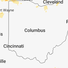
Ohio
| Local Time | Report Details |
|---|---|
| 4:15 PM EDT | Storm damage reported in cuyahoga county OH, 11.8 miles ENE of Cleveland, OH |
| 4:30 PM EDT | Tree limbs down. time estimated by rada in fulton county OH, 58.1 miles NE of Fort Wayne, IN |
| 4:30 PM EDT | Damage to shipping containers and trucks. time estimated by rada in fulton county OH, 57.8 miles NE of Fort Wayne, IN |
| 4:32 PM EDT | Trees and power lines down in fayette. time estimated from rada in fulton county OH, 57.8 miles NE of Fort Wayne, IN |
| 4:33 PM EDT | Storm damage reported in fulton county OH, 55.7 miles NE of Fort Wayne, IN |
| 4:36 PM EDT | Wires and trees down... rockefeller rd. the road was completely blocke in lake county OH, 13.2 miles ENE of Cleveland, OH |
| 4:39 PM EDT | Tree down in the west bound lane of gates mills blv in cuyahoga county OH, 14.1 miles E of Cleveland, OH |
| 5:00 PM EDT | Tree down. time estimated by rada in fulton county OH, 65 miles NE of Fort Wayne, IN |
| 5:03 PM EDT | Trees and wires dow in cuyahoga county OH, 14.1 miles E of Cleveland, OH |
| 5:04 PM EDT | Quarter sized hail reported near Wauseon, OH, 64.9 miles NE of Fort Wayne, IN |
| 5:10 PM EDT | Tree down chagrin river rd and ceda in cuyahoga county OH, 14.6 miles E of Cleveland, OH |
| 5:24 PM EDT | Power line down. time estimated from rada in fulton county OH, 72.1 miles ENE of Fort Wayne, IN |
| 5:30 PM EDT | Tree fell on power lines on swauger valley road near dutch ridge road. time estimated from rada in scioto county OH, 74.8 miles WNW of Charleston, WV |
| 6:22 PM EDT | Large limb dow in fulton county OH, 62.1 miles NE of Fort Wayne, IN |
| 7:46 PM EDT | Three inch tree limbs dow in allen county OH, 50 miles ESE of Fort Wayne, IN |
| 7:50 PM EDT | Large tree fell. time estimated from rada in mercer county OH, 45.8 miles SE of Fort Wayne, IN |
| 7:50 PM EDT | Semi-trailer carrying mostly empty load flipped on us-33 near celina-mendon roa in mercer county OH, 42.5 miles SE of Fort Wayne, IN |
| 10:42 PM EDT | Several poles and trees down on main st. and state route 269 north to state route in erie county OH, 58.6 miles W of Cleveland, OH |
| 11:30 PM EDT | Trees into houses... wires down from state route 611 north to along state 6 to sheffield lak in lorain county OH, 24 miles W of Cleveland, OH |
| 11:40 PM EDT | A picture from social media showed large tree limb blown down and blocking road near 2000 e 31st stree in cuyahoga county OH, 1.1 miles ENE of Cleveland, OH |
| 11:50 PM EDT | Picture from social media report shows a couple pine trees blown down. one tree fell on gates mill blvd. time was estimate in cuyahoga county OH, 12.5 miles E of Cleveland, OH |
| 11:56 PM EDT | Tree down glenway rd... tree down with multiple power lines dow in cuyahoga county OH, 9.9 miles SW of Cleveland, OH |
Alabama
| Local Time | Report Details |
|---|---|
| 3:32 PM CDT | Corrects previous tstm wnd dmg report from 2 nne decatur. a tree was reported down on a house at this locatio in morgan county AL, 42.5 miles ESE of Florence, AL |
| 3:32 PM CDT | Corrects previous tstm wnd dmg report from 2 nne decatur. tree was reported down on the road at the intersection of jackson street se and 8th avenue s in morgan county AL, 41.9 miles ESE of Florence, AL |
| 3:32 PM CDT | Corrects previous tstm wnd dmg report from 2 nnw decatur. tree reported down on road at the intersection of 7th avenue w and 1st street s in morgan county AL, 40.9 miles ESE of Florence, AL |
| 3:32 PM CDT | Corrects previous tstm wnd dmg report from 3 n decatur. tree reported down on a house at this location on vine stree in morgan county AL, 41.7 miles ESE of Florence, AL |
| 3:40 PM CDT | Large tree down at the corner of grant and church stree in morgan county AL, 42.5 miles ESE of Florence, AL |
| 4:05 PM CDT | Ema got reports of trees down along co road 11 southwest of vin in franklin county AL, 42.1 miles SW of Florence, AL |
| 5:32 PM CDT | A tree was reported down on a house at this locatio in morgan county AL, 42.5 miles ESE of Florence, AL |
| 5:32 PM CDT | Tree was reported down on the road at the intersection of jackson street se and 8th avenue s in morgan county AL, 41.9 miles ESE of Florence, AL |
| 5:32 PM CDT | Tree reported down on road at the intersection of 7th avenue w and 1st street s in morgan county AL, 40.9 miles ESE of Florence, AL |
| 5:32 PM CDT | Tree reported down on a house at this location on vine stree in morgan county AL, 41.7 miles ESE of Florence, AL |
Georgia
| Local Time | Report Details |
|---|---|
| 4:34 PM EDT | Tree down on chauncer milan rd near the intersection with ga hwy 11 in telfair county GA, 34.2 miles NNW of Douglas, GA |
| 4:46 PM EDT | Tree down on powerlines at the intersection of hwy 280 and petross r in montgomery county GA, 49.7 miles NNE of Douglas, GA |
| 4:46 PM EDT | Tree down on powerlines at the intersection of hwy 280 and e church s in montgomery county GA, 49.5 miles NNE of Douglas, GA |
| 5:05 PM EDT | Tree down on powerlines at the intersection of fire tower rd and hwy 22 in montgomery county GA, 44.8 miles NNE of Douglas, GA |
| 5:10 PM EDT | Tree down across the road at the intersection of gibbs bridge rd and jones r in montgomery county GA, 43.4 miles NNE of Douglas, GA |
| 5:40 PM EDT | Trees reported down in hazlehurst. time given was based on rada in jeff davis county GA, 29.1 miles NNE of Douglas, GA |
| 6:45 PM EDT | Tree down on old sr5 in worth county GA, 62.1 miles W of Douglas, GA |
| 7:15 PM EDT | Power line down near dogwood lane and wynn driv in worth county GA, 66.1 miles W of Douglas, GA |
| 7:35 PM EDT | Grass fire due to power line along highway 19 north...likely already out due to rain. report via mitchell county scanne in mitchell county GA, 68.9 miles N of Tallahassee, FL |
| 8:15 PM EDT | Tree down on wayback roa in calhoun county GA, 82.6 miles SSE of Auburn, AL |
| 8:32 PM EDT | Widespread power outages reported in western calhoun county on ga power website with cause listed as severe weather moving through are in calhoun county GA, 82.2 miles SSE of Auburn, AL |
| 9:25 PM EDT | Scattered trees and power lines down in seminole count in seminole county GA, 50.9 miles NW of Tallahassee, FL |
Florida
| Local Time | Report Details |
|---|---|
| 5:00 PM EDT | Tree down near the intersection of natural wells dr and blue waters roa in leon county FL, 9.9 miles SSE of Tallahassee, FL |
| 7:28 PM CDT | Eglin afb weather ops reported a 59mph wind gust with thunderstorm passag in okaloosa county FL, 22.4 miles NW of Miramar Beach, FL |
South Dakota
| Local Time | Report Details |
|---|---|
| 3:40 PM MDT | Storm damage reported in custer county SD, 33.8 miles SSE of Rapid City, SD |
| 6:08 PM CDT | 60-65 mph estimated wind gust. radar estimated tim in jones county SD, 25.7 miles S of Pierre, SD |
| 5:35 PM MDT | Quarter sized hail reported near Oglala, SD, 64.1 miles SSE of Rapid City, SD |
| 6:44 PM CDT | Storm damage reported in lyman county SD, 34.8 miles SSE of Pierre, SD |
| 6:57 PM CDT | Golf Ball sized hail reported near Kennebec, SD, 40.5 miles SE of Pierre, SD, at least 60 mph wind gust as well. radar estimated time. |
| 7:45 PM CDT | Strong wind gusts at leading edge of storm blew plastic play set across the yard... ripped off roof shingles... and broke drain spouts. ground covered with pea-sized ha in brule county SD, 68 miles SE of Pierre, SD |
| 7:52 PM CDT | Estimated 60 mph wind gust at leading edge of storm. hail up to the size of pennies. heavy rain followed the wind and hai in brule county SD, 72.4 miles SE of Pierre, SD |
Nebraska
| Local Time | Report Details |
|---|---|
| 3:55 PM MDT | Quarter sized hail reported near Alliance, NE, 44 miles ENE of Scottsbluff, NE, just a few. |
| 4:27 PM MDT | Tennis Ball sized hail reported near Angora, NE, 33.7 miles E of Scottsbluff, NE, reports of vehicles with smashed windshields. |
| 4:27 PM MDT | Tea Cup sized hail reported near Angora, NE, 33.7 miles E of Scottsbluff, NE, a couple 3+ inch stones on hwy 385 near mile marker 95. |
| 4:46 PM MDT | Tennis Ball sized hail reported near Harrison, NE, 45.1 miles N of Scottsbluff, NE |
| 5:30 PM MDT | Golf Ball sized hail reported near Lisco, NE, 59.1 miles ESE of Scottsbluff, NE, range from dimes to golf balls. lasted approximated 5 to 8 minutes. |
| 5:37 PM MDT | Baseball sized hail reported near Lisco, NE, 61 miles ESE of Scottsbluff, NE, extensive damage at property including to windows and siding of house. |
| 5:59 PM MDT | Golf Ball sized hail reported near Oshkosh, NE, 76.8 miles ESE of Scottsbluff, NE, hail destroyed windshield of vehicle. |
| 6:00 PM MDT | 32 inch diameter tree uprooted. time estimated in garden county NE, 75.3 miles ESE of Scottsbluff, NE |
| 7:02 PM CDT | Reported at 970 archer rd... ne large tree limbs dow in merrick county NE, 16.8 miles NE of Grand Island, NE |
| 7:02 PM CDT | Golf Ball sized hail reported near Archer, NE, 16.8 miles NE of Grand Island, NE, reported at 970 archer rd... ne. |
| 6:05 PM MDT | Golf Ball sized hail reported near Oshkosh, NE, 75.3 miles ESE of Scottsbluff, NE, lots of hail damage in town. time estimated by radar |
| 6:12 PM MDT | Hen Egg sized hail reported near Oshkosh, NE, 78.2 miles ESE of Scottsbluff, NE, hail of 2.25 inches in diameter. report with photo from social media. |
| 7:30 PM CDT | Strong winds observed... limbs dow in merrick county NE, 22.3 miles NE of Grand Island, NE |
| 7:36 PM CDT | Quarter sized hail reported near Marquette, NE, 20.4 miles ENE of Grand Island, NE |
| 6:45 PM MDT | Golf Ball sized hail reported near Lewellen, NE, 72.1 miles W of North Platte, NE, delayed report relayed by coop observer of golf ball hail and damage to buildings in the area. |
| 7:48 PM CDT | Large limbs down... structural damage to a she in york county NE, 30.2 miles E of Grand Island, NE |
| 6:50 PM MDT | Tea Cup sized hail reported near Big Springs, NE, 68.2 miles W of North Platte, NE, hail up to 3.5 inch. picture provided via social media |
| 6:55 PM MDT | Storm damage reported in keith county NE, 66.2 miles W of North Platte, NE |
| 6:56 PM MDT | Golf Ball sized hail reported near Brule, NE, 60.9 miles W of North Platte, NE, hail ranged from marbles to golf balls. |
| 7:57 PM CDT | Golf Ball sized hail reported near Benedict, NE, 39.1 miles E of Grand Island, NE |
| 8:00 PM CDT | Golf Ball sized hail reported near Waco, NE, 46.1 miles E of Grand Island, NE |
| 7:05 PM MDT | Quarter sized hail reported near Brule, NE, 58.9 miles W of North Platte, NE, hail up to quarter size in town. picture via social media |
| 8:05 PM CDT | Half Dollar sized hail reported near York, NE, 39.5 miles E of Grand Island, NE |
| 8:05 PM CDT | Half Dollar sized hail reported near York, NE, 38.7 miles E of Grand Island, NE |
| 8:08 PM CDT | Half Dollar sized hail reported near York, NE, 39.8 miles E of Grand Island, NE |
| 8:15 PM CDT | Storm damage reported in york county NE, 37.8 miles E of Grand Island, NE |
| 7:21 PM MDT | Golf Ball sized hail reported near Grant, NE, 54.6 miles W of North Platte, NE |
| 8:23 PM CDT | Ping Pong Ball sized hail reported near Utica, NE, 52.4 miles E of Grand Island, NE, hail broke windows and put holes in siding in homes. |
| 8:25 PM CDT | Half Dollar sized hail reported near Utica, NE, 52.4 miles E of Grand Island, NE |
| 7:33 PM MDT | Grapefruit sized hail reported near Grant, NE, 53.3 miles WSW of North Platte, NE, report with picture via social media. |
| 8:36 PM CDT | Golf Ball sized hail reported near Alda, NE, 8.1 miles WSW of Grand Island, NE |
| 7:41 PM MDT | Tennis Ball sized hail reported near Grant, NE, 54.3 miles WSW of North Platte, NE, measured 3 inch hail on north side of grant. |
| 8:43 PM CDT | Ping Pong Ball sized hail reported near Seward, NE, 59.8 miles E of Grand Island, NE |
| 7:45 PM MDT | Tea Cup sized hail reported near Grant, NE, 53.6 miles WSW of North Platte, NE, via social media |
| 8:05 PM MDT | Tea Cup sized hail reported near Grant, NE, 51.2 miles WSW of North Platte, NE |
| 8:06 PM MDT | Quarter sized hail reported near Madrid, NE, 51.1 miles SW of North Platte, NE |
| 9:30 PM CDT | Quarter sized hail reported near Aurora, NE, 22.7 miles SE of Grand Island, NE |
| 9:43 PM CDT | Quarter sized hail reported near Aurora, NE, 29.6 miles ESE of Grand Island, NE |
Illinois
| Local Time | Report Details |
|---|---|
| 5:58 PM CDT | Roof was blown off a building on vermillion st between holmes and pine. half of a tree fell onto a house on washington street. a 4-6 inch diameter tree limb fell on cen in ford county IL, 69.1 miles NNE of Mattoon, IL |
| 7:30 PM CDT | Numerous tree limbs down...some roads blocked in vermilion county IL, 72.1 miles NNE of Mattoon, IL |
| 8:35 PM CDT | Estimated 60 mph wind gusts. no damage note in ford county IL, 69.1 miles NNE of Mattoon, IL |
| 8:55 PM CDT | Motorcycle blown off of interstate 57 at mile marker 263. time approximate from paxton em in ford county IL, 71.1 miles NNE of Mattoon, IL |
| 9:37 PM CDT | A tree down on roadway at henning road and highway 136 in henning. also some tree limbs and power lines down from a thunderstor in vermilion county IL, 67.5 miles NNE of Mattoon, IL |
| 9:55 PM CDT | Rantoul airport measured a 64 mph wind gust out of the northeast from a thunderstor in champaign county IL, 57.6 miles NNE of Mattoon, IL |
| 10:10 PM CDT | Quarter sized hail reported near Potomac, IL, 63 miles NNE of Mattoon, IL, public report of quarter size hail 2 miles south of potomac. report relayed to nws by ema department. |
| 10:18 PM CDT | Quarter sized hail reported near Danville, IL, 62.8 miles NE of Mattoon, IL, estimated 1 inch hail west of lake vermilion near old ottawa and denmark roads. |
| 1:45 AM CDT | Power pole down in mason county IL, 26.4 miles S of Peoria, IL |
| 1:45 AM CDT | Power pole down in logan county IL, 26.4 miles S of Peoria, IL |
| 2:05 AM CDT | Tree branch down on power lines in logan county IL, 39.1 miles SSE of Peoria, IL |
| 2:15 AM CDT | Multiple power lines down in logan county IL, 35.3 miles SSE of Peoria, IL |
Indiana
| Local Time | Report Details |
|---|---|
| 7:03 PM EDT | Penny sized hail and estimated wind gusts of 40 to 50 mp in st. joseph county IN, 72.6 miles E of Chicago, IL |
| 8:14 PM EDT | Medium sized limb down blocking half of sr 119 as wel in elkhart county IN, 54.7 miles NW of Fort Wayne, IN |
| 8:35 PM EDT | Several tree limbs dow in steuben county IN, 45.3 miles N of Fort Wayne, IN |
| 8:40 PM EDT | Several downed trees near deniston nature preserve. time estimated from rada in whitley county IN, 30.2 miles WNW of Fort Wayne, IN |
| 9:00 PM EDT | Power lines dow in steuben county IN, 34.8 miles NNE of Fort Wayne, IN |
| 9:05 PM EDT | Large tree fell on a house and took down power lines. time estimated from rada in whitley county IN, 21.2 miles WNW of Fort Wayne, IN |
| 9:52 PM EDT | Tree split and fel in elkhart county IN, 49.8 miles NW of Fort Wayne, IN |
| 12:17 AM EDT | Relayed via social medi in boone county IN, 35.2 miles NW of Indianapolis, IN |
| 12:56 AM EDT | Off duty tv meteorologist reported a transmitter blew across the stree in marion county IN, 13 miles NW of Indianapolis, IN |
| 1:40 AM EDT | Large limbs were down on power lines... a transformer exploded. a pole caught fire. location was along allisonville road... just south of 56th st. the road was closed i in marion county IN, 0.9 miles N of Indianapolis, IN |
Minnesota
| Local Time | Report Details |
|---|---|
| 6:36 PM CDT | Multiple trees 5 to 6 inches in diameter reported down on the south side of paynesville. time estimated from rada in stearns county MN, 56.7 miles ENE of Montevideo, MN |
Kansas
| Local Time | Report Details |
|---|---|
| 6:38 PM CDT | Ping Pong Ball sized hail reported near Sabetha, KS, 59.3 miles NE of Manhattan, KS |
| 7:05 PM CDT | Highway k 170 closed due to power lines on the roa in osage county KS, 58.1 miles SE of Manhattan, KS |
| 7:40 PM CDT | Tree down - unknown size. two small fences were blown ove in lyon county KS, 55.5 miles SSE of Manhattan, KS |
| 7:42 PM CDT | Shed destroyed. winds were estimated around 60 mp in lyon county KS, 56.3 miles SSE of Manhattan, KS |
| 8:12 PM CDT | Time estimated by radar. small limbs were also reported dow in osage county KS, 59.7 miles SE of Manhattan, KS |
Missouri
| Local Time | Report Details |
|---|---|
| 6:56 PM CDT | Delayed report. time-matched to radar. westboro fire department reports multiple trees and limbs down... along with building damage throughout tow in atchison county MO, 59.4 miles SSE of Omaha, NE |
| 7:00 PM CDT | Time matched to rada in atchison county MO, 60.6 miles SE of Omaha, NE |
| 7:14 PM CDT | Delayed report. large limbs down. time-matched to rada in nodaway county MO, 66.8 miles SE of Omaha, NE |
| 7:19 PM CDT | Delayed report. time-matched to radar. sheriff reported a tree on a hous in nodaway county MO, 72.5 miles SE of Omaha, NE |
| 7:30 PM CDT | Storm damage reported in nodaway county MO, 82.2 miles SE of Omaha, NE |
| 7:36 PM CDT | Storm damage reported in nodaway county MO, 81.1 miles SE of Omaha, NE |
| 8:05 PM CDT | A few trees down and some roof damage at days inn in st. joseph. time-matched to radar along gust fron in buchanan county MO, 48.4 miles NNW of Kansas City, MO |
| 8:39 PM CDT | Delayed report. time-matched to radar. 4.5" limd down at 24 highway and arlington avenue in independence... in addition to multiple power lines down and power outage in jackson county MO, 6.7 miles E of Kansas City, MO |
| 8:51 PM CDT | Delayed report. time-matched to radar. tree down on us69 north of bethan in harrison county MO, 89.3 miles NNE of Kansas City, MO |
| 9:20 PM CDT | Report from social media. 5" branch snapped off tree along gust fron in caldwell county MO, 47.5 miles NE of Kansas City, MO |
| 12:05 AM CDT | Centralia police dept stated that there are numerous power outages in the area. multiple trees and limbs are down... per officers patrolling the area. no estimated of w in boone county MO, 20.9 miles NNE of Columbia, MO |
| 12:25 AM CDT | Mexico police dept reported trees and power lines down through the area with multiple power outages. dept continued to receive high winds at the time of call at 1230a in audrain county MO, 28.7 miles ENE of Columbia, MO |
| 1:38 AM CDT | Several trees and tree limbs blown dow in pike county MO, 66.5 miles ENE of Columbia, MO |
Iowa
| Local Time | Report Details |
|---|---|
| 7:10 PM CDT | Tree limbs blown dow in page county IA, 60.9 miles SE of Omaha, NE |
Vermont
| Local Time | Report Details |
|---|---|
| 8:23 PM EDT | Us customs reports several trees down along highway 114 south of norto in essex county VT, 78.1 miles ENE of Burlington, VT |
Louisiana
| Local Time | Report Details |
|---|---|
| 7:25 PM CDT | Sheriff department reports trees and power lines down on lane road just off of highway 15 in winn county LA, 66.3 miles SE of Shreveport, LA |
| 7:30 PM CDT | Sheriff department reports trees down on road near intersection of lakeshore and coldwater road in winn county LA, 65.7 miles SE of Shreveport, LA |
Connect with Interactive Hail Maps