

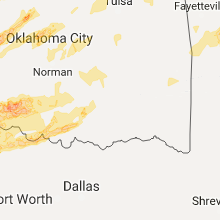
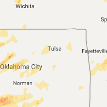
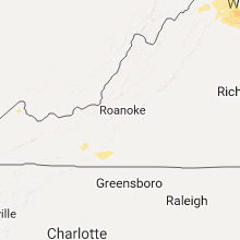
Hail Map for Thursday, May 18, 2017

Number of Impacted Households on 5/18/2017
0
Impacted by 1" or Larger Hail
0
Impacted by 1.75" or Larger Hail
0
Impacted by 2.5" or Larger Hail
Square Miles of Populated Area Impacted on 5/18/2017
0
Impacted by 1" or Larger Hail
0
Impacted by 1.75" or Larger Hail
0
Impacted by 2.5" or Larger Hail


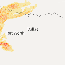


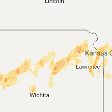


Cities Most Affected by Hail Storms of 5/18/2017
| Hail Size | Demographics of Zip Codes Affected | ||||||
|---|---|---|---|---|---|---|---|
| City | Count | Average | Largest | Pop Density | House Value | Income | Age |
| Fulton, NY | 4 | 2.19 | 2.50 | 236 | $68k | $34.4k | 38.2 |
| Granite, OK | 3 | 1.83 | 2.00 | 5 | $38k | $28.4k | 37.0 |
| Pueblo, CO | 3 | 1.75 | 1.75 | 208 | $139k | $47.8k | 37.6 |
| Brewerton, NY | 3 | 1.75 | 1.75 | 383 | $88k | $52.1k | 38.8 |
| Coleman, TX | 2 | 2.13 | 2.50 | 15 | $34k | $25.8k | 45.4 |
| Rising Star, TX | 2 | 2.13 | 2.50 | 7 | $29k | $27.2k | 48.2 |
| Dodge City, KS | 2 | 2.00 | 2.00 | 82 | $71k | $37.6k | 29.5 |
| Fargo, OK | 2 | 1.88 | 2.00 | 2 | $51k | $31.0k | 43.0 |
| Alta Vista, KS | 2 | 1.88 | 2.00 | 4 | $46k | $35.0k | 46.5 |
| Council Grove, KS | 2 | 1.75 | 1.75 | 12 | $55k | $31.9k | 48.5 |
| Crowell, TX | 2 | 1.75 | 1.75 | 1 | $26k | $25.6k | 46.8 |
| Hennessey, OK | 2 | 1.75 | 1.75 | 15 | $54k | $31.4k | 35.6 |
| Cross Plains, TX | 2 | 1.75 | 1.75 | 10 | $34k | $23.0k | 47.8 |
| Electra, TX | 1 | 2.75 | 2.75 | 11 | $30k | $26.5k | 41.9 |
| Talpa, TX | 1 | 2.75 | 2.75 | 2 | $29k | $22.1k | 53.5 |
| Eldorado, OK | 1 | 2.75 | 2.75 | 2 | $33k | $23.2k | 44.4 |
| Duke, OK | 1 | 2.75 | 2.75 | 2 | $52k | $35.4k | 37.3 |
| Mexico, NY | 1 | 2.50 | 2.50 | 86 | $72k | $42.1k | 39.9 |
| Mangum, OK | 1 | 2.50 | 2.50 | 9 | $32k | $24.4k | 42.3 |
| Bonner Springs, KS | 1 | 2.50 | 2.50 | 230 | $100k | $47.3k | 38.9 |
| Cordell, OK | 1 | 2.00 | 2.00 | 17 | $43k | $27.7k | 40.3 |
| Springville, NY | 1 | 2.00 | 2.00 | 109 | $88k | $39.5k | 42.3 |
| Halstead, KS | 1 | 1.75 | 1.75 | 36 | $74k | $42.8k | 40.3 |
| Lenexa, KS | 1 | 1.75 | 1.75 | 382 | $154k | $67.0k | 38.1 |
| Kansas City, KS | 1 | 1.75 | 1.75 | 466 | $86k | $56.0k | 38.3 |
| Saint John, KS | 1 | 1.75 | 1.75 | 5 | $43k | $33.4k | 45.5 |
| Alma, KS | 1 | 1.75 | 1.75 | 6 | $69k | $42.6k | 46.5 |
| Ellis, KS | 1 | 1.75 | 1.75 | 8 | $55k | $30.4k | 40.4 |
| Freedom, OK | 1 | 1.75 | 1.75 | 1 | $45k | $32.6k | 47.0 |
| Walters, OK | 1 | 1.75 | 1.75 | 13 | $54k | $30.0k | 39.5 |
| Clyde, TX | 1 | 1.75 | 1.75 | 27 | $57k | $34.1k | 40.7 |
| Ellsworth, KS | 1 | 1.75 | 1.75 | 13 | $48k | $37.4k | 39.8 |
| Baird, TX | 1 | 1.75 | 1.75 | 7 | $41k | $30.3k | 46.4 |
| Abilene, TX | 1 | 1.75 | 1.75 | 75 | $58k | $26.3k | 30.2 |
| Great Bend, KS | 1 | 1.75 | 1.75 | 78 | $61k | $33.4k | 38.0 |
| Altmar, NY | 1 | 1.75 | 1.75 | 29 | $62k | $35.1k | 37.3 |
| Auburn, NY | 1 | 1.75 | 1.75 | 315 | $76k | $35.6k | 41.9 |
| Maple Hill, KS | 1 | 1.75 | 1.75 | 10 | $78k | $47.4k | 35.9 |
| Breckenridge, TX | 1 | 1.75 | 1.75 | 16 | $45k | $29.6k | 39.3 |
| Maysville, OK | 1 | 1.75 | 1.75 | 12 | $42k | $27.0k | 39.8 |
| Holliday, TX | 1 | 1.75 | 1.75 | 3 | $52k | $34.3k | 43.3 |
| Junction City, KS | 1 | 1.75 | 1.75 | 128 | $67k | $31.2k | 29.3 |
| Weatherford, OK | 1 | 1.75 | 1.75 | 64 | $84k | $28.5k | 26.4 |
| Smithville, MO | 1 | 1.75 | 1.75 | 183 | $126k | $58.3k | 39.2 |
Hail and Wind Damage Spotted on 5/18/2017
Filter by Report Type:Hail ReportsWind Reports
States Impacted
Texas, Oklahoma, New York, Colorado, Ohio, West Virginia, Maryland, Pennsylvania, Indiana, Georgia, Kansas, Virginia, Vermont, New Hampshire, Illinois, Massachusetts, Maine, Missouri, Connecticut, ArkansasTexas
| Local Time | Report Details |
|---|---|
| 1:45 PM CDT | Quarter sized hail reported near Guthrie, TX, 55.5 miles S of Childress, TX |
| 2:40 PM CDT | Golf Ball sized hail reported near Crowell, TX, 45.9 miles SSE of Childress, TX |
| 2:41 PM CDT | Ping Pong Ball sized hail reported near Crowell, TX, 42.5 miles SSE of Childress, TX |
| 2:45 PM CDT | Quarter sized hail reported near Canadian, TX, 66.9 miles SW of Woodward, OK |
| 2:50 PM CDT | Golf Ball sized hail reported near Crowell, TX, 55.5 miles SSE of Childress, TX |
| 2:50 PM CDT | Half Dollar sized hail reported near Canadian, TX, 65.7 miles WSW of Woodward, OK |
| 2:50 PM CDT | Half Dollar sized hail reported near Canadian, TX, 66 miles WSW of Woodward, OK |
| 2:52 PM CDT | Ping Pong Ball sized hail reported near Canadian, TX, 65.6 miles SW of Woodward, OK |
| 4:29 PM CDT | Baseball sized hail reported near Talpa, TX, 35.8 miles S of Abilene, TX |
| 4:48 PM CDT | Half Dollar sized hail reported near Novice, TX, 32.4 miles SSE of Abilene, TX, half dollar size hail was reported. |
| 4:52 PM CDT | Ping Pong Ball sized hail reported near Novice, TX, 32.4 miles SSE of Abilene, TX, ping pong ball size hail was reported. |
| 5:08 PM CDT | Half Dollar sized hail reported near Novice, TX, 35.7 miles SSE of Abilene, TX, half dollar size hail was reported. |
| 5:25 PM CDT | Golf Ball sized hail reported near Clyde, TX, 13 miles SE of Abilene, TX |
| 5:28 PM CDT | Quarter sized hail reported near Clyde, TX, 14.5 miles ESE of Abilene, TX, hail up to quarter size was reported. |
| 5:31 PM CDT | Golf Ball sized hail reported near Abilene, TX, 12.2 miles NE of Abilene, TX |
| 5:32 PM CDT | Tennis Ball sized hail reported near Coleman, TX, 40.2 miles SSE of Abilene, TX, hail also took out windshield |
| 5:35 PM CDT | Golf Ball sized hail reported near Baird, TX, 29.1 miles SE of Abilene, TX, golball size hail was reported on the south side of lake coleman. |
| 5:35 PM CDT | Golf Ball sized hail reported near Coleman, TX, 33.3 miles SSE of Abilene, TX, golball size hail was reported on the south side of lake coleman. |
| 5:48 PM CDT | Wind damage was reported to carports and canopies of residences at lake coleman. roof shingle damage was also reporte in callahan county TX, 29.1 miles SE of Abilene, TX |
| 5:48 PM CDT | Wind damage was reported to carports and canopies of residences at lake coleman. roof shingle damage was also reporte in coleman county TX, 33.3 miles SSE of Abilene, TX |
| 6:10 PM CDT | Ping Pong Ball sized hail reported near Electra, TX, 26.2 miles WNW of Wichita Falls, TX |
| 6:13 PM CDT | Quarter sized hail reported near Electra, TX, 26.2 miles WNW of Wichita Falls, TX |
| 6:51 PM CDT | Baseball sized hail reported near Electra, TX, 19.2 miles W of Wichita Falls, TX |
| 7:04 PM CDT | Quarter sized hail reported near Cross Plains, TX, 46 miles SE of Abilene, TX, quarter size hail was reported. |
| 7:11 PM CDT | Golf Ball sized hail reported near Cross Plains, TX, 40 miles ESE of Abilene, TX |
| 7:16 PM CDT | Golf Ball sized hail reported near Cross Plains, TX, 40 miles ESE of Abilene, TX |
| 7:22 PM CDT | Golf Ball sized hail reported near Rising Star, TX, 51.2 miles ESE of Abilene, TX, golf ball sized hail just south of rising star |
| 7:27 PM CDT | Quarter sized hail reported near Cross Plains, TX, 46 miles SE of Abilene, TX, quarter size hail was reported. |
| 7:39 PM CDT | Power lines and power poles were blown down. large trees also dow in brown county TX, 47.8 miles SE of Abilene, TX |
| 8:04 PM CDT | Tennis Ball sized hail reported near Rising Star, TX, 51.2 miles ESE of Abilene, TX, 2.5 inch hail reported in the city of rising star |
| 8:15 PM CDT | Quarter sized hail reported near Holliday, TX, 25.2 miles SW of Wichita Falls, TX |
| 8:15 PM CDT | Golf Ball sized hail reported near Holliday, TX, 25.4 miles WSW of Wichita Falls, TX |
| 9:00 PM CDT | Golf Ball sized hail reported near Breckenridge, TX, 53.3 miles ENE of Abilene, TX, delayed report: trained spotter report golf ball to baseball size hail east of brekenridge. |
| 9:02 PM CDT | Quarter sized hail reported near Breckenridge, TX, 53.3 miles ENE of Abilene, TX, delayed report: quarter size hail report near breckenridge |
| 9:16 PM CDT | Quarter sized hail reported near Wichita Falls, TX, 15.6 miles SSE of Wichita Falls, TX |
| 10:01 PM CDT | Quarter sized hail reported near Blackwell, TX, 42 miles SW of Abilene, TX, quarter size hail was reported. |
| 10:16 PM CDT | Quarter sized hail reported near Nocona, TX, 44.5 miles E of Wichita Falls, TX, volunteer fire department report quarter size hail in northwest nocona. |
| 11:02 PM CDT | Quarter sized hail reported near Pottsville, TX, 53.8 miles NW of Killeen, TX, amateur radio report quarter size hail 3 miles east of indian gap |
| 11:25 PM CDT | Quarter sized hail reported near Hamilton, TX, 46.4 miles NNW of Killeen, TX, quarter size hail report just west of the city of hamilton |
| 2:45 AM CDT | Half Dollar sized hail reported near Colorado City, TX, 65.5 miles W of Abilene, TX |
Oklahoma
| Local Time | Report Details |
|---|---|
| 2:00 PM CDT | Baseball sized hail reported near Duke, OK, 38.7 miles ENE of Childress, TX |
| 2:14 PM CDT | Tennis Ball sized hail reported near Mangum, OK, 51 miles NE of Childress, TX |
| 2:15 PM CDT | Quarter sized hail reported near Blair, OK, 55.7 miles ENE of Childress, TX |
| 2:20 PM CDT | Baseball sized hail reported near Eldorado, OK, 23.2 miles E of Childress, TX |
| 2:36 PM CDT | Golf Ball sized hail reported near Granite, OK, 59.5 miles NE of Childress, TX |
| 2:47 PM CDT | Hen Egg sized hail reported near Granite, OK, 60.2 miles NE of Childress, TX |
| 2:47 PM CDT | Golf Ball sized hail reported near Granite, OK, 59.8 miles NE of Childress, TX |
| 2:55 PM CDT | At least 12 power poles snapped of at various height in ellis county OK, 24.1 miles WSW of Woodward, OK |
| 3:00 PM CDT | Storm damage reported in ellis county OK, 24.1 miles WSW of Woodward, OK |
| 3:19 PM CDT | Quarter sized hail reported near Fort Supply, OK, 14.2 miles NW of Woodward, OK |
| 3:38 PM CDT | Golf Ball sized hail reported near Fargo, OK, 12.9 miles WSW of Woodward, OK |
| 3:41 PM CDT | Ping Pong Ball sized hail reported near Fort Supply, OK, 13.5 miles NW of Woodward, OK, on hwy 183. |
| 3:43 PM CDT | Golf Ball sized hail reported near Freedom, OK, 18.6 miles N of Woodward, OK |
| 3:43 PM CDT | Hen Egg sized hail reported near Fargo, OK, 12.3 miles WSW of Woodward, OK |
| 3:50 PM CDT | Storm damage reported in woodward county OK, 1.8 miles WNW of Woodward, OK |
| 4:07 PM CDT | Golf Ball sized hail reported near Weatherford, OK, 66.6 miles W of Oklahoma City, OK, tree limbs downed as well. |
| 4:08 PM CDT | Quarter sized hail reported near Weatherford, OK, 66.6 miles W of Oklahoma City, OK |
| 4:30 PM CDT | Quarter sized hail reported near Davidson, OK, 40.3 miles NW of Wichita Falls, TX |
| 4:31 PM CDT | Hen Egg sized hail reported near Cordell, OK, 80.8 miles SSE of Woodward, OK |
| 4:40 PM CDT | Ping Pong Ball sized hail reported near Fairview, OK, 27 miles E of Woodward, OK, corrected for time. |
| 4:44 PM CDT | Quarter sized hail reported near Davidson, OK, 40.7 miles NW of Wichita Falls, TX |
| 4:55 PM CDT | Ping Pong Ball sized hail reported near Fairview, OK, 27 miles E of Woodward, OK |
| 5:34 PM CDT | Quarter sized hail reported near Oklahoma City, OK, 7.6 miles SE of Oklahoma City, OK |
| 6:10 PM CDT | Storm damage reported in cotton county OK, 31.9 miles NNE of Wichita Falls, TX |
| 6:15 PM CDT | Storm damage reported in cotton county OK, 34.8 miles NNE of Wichita Falls, TX |
| 6:16 PM CDT | Measured at se 45th and highway 7 in comanche county OK, 48.5 miles N of Wichita Falls, TX |
| 6:16 PM CDT | Quarter sized hail reported near Mcloud, OK, 24.4 miles E of Oklahoma City, OK |
| 6:16 PM CDT | Half Dollar sized hail reported near Woodward, OK, 1.4 miles SE of Woodward, OK |
| 6:17 PM CDT | Golf Ball sized hail reported near Walters, OK, 33 miles NNE of Wichita Falls, TX |
| 6:19 PM CDT | Golf Ball sized hail reported near Hennessey, OK, 44.1 miles NNW of Oklahoma City, OK |
| 6:30 PM CDT | Barn destroyed on plato r in stephens county OK, 50.1 miles NE of Wichita Falls, TX |
| 6:33 PM CDT | Golf Ball sized hail reported near Maysville, OK, 50.8 miles S of Oklahoma City, OK |
| 6:33 PM CDT | Golf Ball sized hail reported near Hennessey, OK, 46.9 miles NNW of Oklahoma City, OK |
| 7:05 PM CDT | Ping Pong Ball sized hail reported near Duncan, OK, 47.1 miles NE of Wichita Falls, TX |
| 7:10 PM CDT | Storm damage reported in woods county OK, 41 miles ENE of Woodward, OK |
| 7:36 PM CDT | At will rogers world airpor in oklahoma county OK, 7.8 miles SW of Oklahoma City, OK |
| 7:50 PM CDT | Aircraft hangers damaged at david perry airpor in mcclain county OK, 21.7 miles S of Oklahoma City, OK |
| 7:54 PM CDT | At national weather center on ou campu in cleveland county OK, 20.6 miles SSE of Oklahoma City, OK |
| 7:55 PM CDT | 8 inch dia tree snapped... fence blown away near nw in cleveland county OK, 20 miles SSE of Oklahoma City, OK |
| 8:00 PM CDT | Numerous tree limbs downed in tow in cleveland county OK, 18 miles SSE of Oklahoma City, OK |
| 8:09 PM CDT | Storm damage reported in oklahoma county OK, 8.2 miles ESE of Oklahoma City, OK |
| 8:12 PM CDT | Storm damage reported in tulsa county OK, 7.1 miles WSW of Tulsa, OK |
| 8:20 PM CDT | Estimated 70 mph wind and some shingles blown off roof near se 24th and highway in cleveland county OK, 21.2 miles SSE of Oklahoma City, OK |
| 8:25 PM CDT | Storm damage reported in tulsa county OK, 6.6 miles W of Tulsa, OK |
| 8:30 PM CDT | Quarter sized hail reported near Sapulpa, OK, 12.2 miles SSW of Tulsa, OK, highway 97 at the bowling alley |
| 8:50 PM CDT | Many trees downed... power poles snappe in oklahoma county OK, 22.7 miles NE of Oklahoma City, OK |
| 9:07 PM CDT | Roof blown off home. numerous utility poles dow in pontotoc county OK, 41.1 miles NW of Atoka, OK |
| 9:08 PM CDT | Measured at riverside airpor in tulsa county OK, 8.3 miles S of Tulsa, OK |
| 9:12 PM CDT | Roof missing from house and numerous utility poles downed in tow in pontotoc county OK, 40.7 miles NW of Atoka, OK |
| 9:20 PM CDT | Multiple power poles leaning at up to a 45 deg angle along hwy 53 east of tow in carter county OK, 57.6 miles W of Atoka, OK |
| 9:30 PM CDT | Thunderstorm winds estimated to 65 mph... tree damage in tulsa county OK, 4.3 miles ESE of Tulsa, OK |
| 9:30 PM CDT | Thunderstorm winds estimated to 65 mph... tree damage in tulsa county OK, 4.3 miles ESE of Tulsa, OK |
| 9:33 PM CDT | Measured at riverside airpor in tulsa county OK, 8.3 miles S of Tulsa, OK |
| 9:36 PM CDT | Sheridan and 41st in tulsa county OK, 4.3 miles ESE of Tulsa, OK |
| 9:39 PM CDT | Storm damage reported in tulsa county OK, 7 miles ENE of Tulsa, OK |
| 9:40 PM CDT | Quarter sized hail reported near Holdenville, OK, 50.3 miles NNW of Atoka, OK |
| 9:53 PM CDT | Tree uprooted in turle in tulsa county OK, 6.2 miles N of Tulsa, OK |
| 10:05 PM CDT | Storm damage reported in osage county OK, 31.7 miles NW of Tulsa, OK |
| 10:09 PM CDT | Power lines dow in mcintosh county OK, 58.4 miles NNE of Atoka, OK |
| 10:15 PM CDT | Storm damage reported in mcintosh county OK, 61 miles SSE of Tulsa, OK |
| 10:15 PM CDT | Large tree downed over indian nation turnpike. southbound traffic being diverte in pittsburg county OK, 50.8 miles NNE of Atoka, OK |
| 10:20 PM CDT | Storm damage reported in tulsa county OK, 15.8 miles SSE of Tulsa, OK |
| 10:20 PM CDT | Power poles dow in mcintosh county OK, 53.9 miles SSE of Tulsa, OK |
| 10:30 PM CDT | Storm damage reported in muskogee county OK, 33.9 miles SE of Tulsa, OK |
| 10:39 PM CDT | Storm damage reported in wagoner county OK, 32.8 miles SE of Tulsa, OK |
| 10:40 PM CDT | Roof blown off of whispering pines apartments. time estimated by rada in muskogee county OK, 44.5 miles SE of Tulsa, OK |
| 10:41 PM CDT | Quarter sized hail reported near Ringling, OK, 57 miles E of Wichita Falls, TX |
| 10:50 PM CDT | Car flipped... damage to phillips 66 gas station. possible tornado in wagoner county OK, 37.3 miles ESE of Tulsa, OK |
| 11:05 PM CDT | Trees down and power out near state highway 82 and carters landing roa in cherokee county OK, 42.6 miles NW of Fort Smith, AR |
| 11:05 PM CDT | Tree damage blocking coatsworth road near deadman springs road. time estimate in johnston county OK, 25.9 miles W of Atoka, OK |
| 11:25 PM CDT | Trees and limbs across highway 412. possible tornado. time estimated via rada in delaware county OK, 60.2 miles E of Tulsa, OK |
| 11:26 PM CDT | Half Dollar sized hail reported near Coalgate, OK, 19.2 miles WNW of Atoka, OK |
| 11:44 PM CDT | 50 to 60 mph estimat in delaware county OK, 56.8 miles NNW of Fort Smith, AR |
| 1:40 AM CDT | Quarter sized hail reported near Yukon, OK, 14.4 miles WNW of Oklahoma City, OK, reported 4 miles east of richland. |
| 1:45 AM CDT | Quarter sized hail reported near Yukon, OK, 14 miles WNW of Oklahoma City, OK |
| 2:09 AM CDT | Quarter sized hail reported near Edmond, OK, 15.8 miles N of Oklahoma City, OK, mping report |
| 2:17 AM CDT | Quarter sized hail reported near Edmond, OK, 17.8 miles N of Oklahoma City, OK |
| 2:18 AM CDT | Quarter sized hail reported near Edmond, OK, 20.1 miles N of Oklahoma City, OK, mping report |
| 3:00 AM CDT | Storm damage reported in logan county OK, 26.8 miles N of Oklahoma City, OK |
New York
| Local Time | Report Details |
|---|---|
| 3:22 PM EDT | Quarter sized hail reported near Collins, NY, 26.7 miles S of Buffalo, NY |
| 3:24 PM EDT | Quarter sized hail reported near Livonia, NY, 61.4 miles E of Buffalo, NY |
| 3:24 PM EDT | Quarter sized hail reported near Livonia, NY, 60.4 miles E of Buffalo, NY, half inch to inch sized hail. |
| 3:33 PM EDT | Hen Egg sized hail reported near Springville, NY, 24.1 miles SSE of Buffalo, NY |
| 3:38 PM EDT | Quarter sized hail reported near East Concord, NY, 26.1 miles SSE of Buffalo, NY |
| 4:12 PM EDT | Half Dollar sized hail reported near Phelps, NY, 46.1 miles W of Syracuse, NY, time estimated from radar |
| 4:30 PM EDT | Trees and wires down. time estimated from rada in livingston county NY, 57.9 miles ESE of Buffalo, NY |
| 4:41 PM EDT | Large tree branches down blocking half of st. clair stree in ontario county NY, 44 miles WSW of Syracuse, NY |
| 4:50 PM EDT | Golf Ball sized hail reported near Auburn, NY, 21.9 miles WSW of Syracuse, NY |
| 5:18 PM EDT | Storm damage reported in cayuga county NY, 24.2 miles SW of Syracuse, NY |
| 5:21 PM EDT | Large tree down... several large branches down. powerlines dow in cayuga county NY, 27.2 miles SSW of Syracuse, NY |
| 5:38 PM EDT | Ping Pong Ball sized hail reported near Saint Johnsville, NY, 36.8 miles WNW of Schenectady, NY |
| 5:44 PM EDT | Trees down in lewis county NY, 55 miles S of Ogdensburg, NY |
| 5:48 PM EDT | Trees down in new bremen in lewis county NY, 59 miles S of Ogdensburg, NY |
| 5:49 PM EDT | Trees down... structural damage in cayuga county NY, 26.9 miles SW of Syracuse, NY |
| 5:52 PM EDT | Golf Ball sized hail reported near Brewerton, NY, 13.9 miles N of Syracuse, NY |
| 5:54 PM EDT | Ping Pong Ball sized hail reported near Fulton, NY, 23.2 miles NW of Syracuse, NY |
| 5:55 PM EDT | Ping Pong Ball sized hail reported near Fulton, NY, 23.2 miles NW of Syracuse, NY |
| 5:59 PM EDT | Tennis Ball sized hail reported near Fulton, NY, 22.7 miles NNW of Syracuse, NY, twitter picture of approx tennis ball hail. time estimated from radar |
| 5:59 PM EDT | Trees and wires dow in oswego county NY, 23.1 miles NNW of Syracuse, NY |
| 5:59 PM EDT | Ping Pong Ball sized hail reported near Phoenix, NY, 14.1 miles NNW of Syracuse, NY |
| 6:00 PM EDT | Hen Egg sized hail reported near Fulton, NY, 24.8 miles NNW of Syracuse, NY, reports of multiple car windows smashed and damage to siding. time estimated from radar |
| 6:00 PM EDT | Tennis Ball sized hail reported near Fulton, NY, 24 miles NNW of Syracuse, NY |
| 6:00 PM EDT | Ping Pong Ball sized hail reported near Fulton, NY, 23.2 miles NW of Syracuse, NY |
| 6:02 PM EDT | Quarter sized hail reported near Gloversville, NY, 30.4 miles NW of Schenectady, NY |
| 6:05 PM EDT | Ping Pong Ball sized hail reported near Central Square, NY, 13.8 miles N of Syracuse, NY |
| 6:05 PM EDT | Half Dollar sized hail reported near Brewerton, NY, 13.1 miles N of Syracuse, NY |
| 6:05 PM EDT | Golf Ball sized hail reported near Fulton, NY, 25.1 miles NNW of Syracuse, NY, golf ball sized hail |
| 6:06 PM EDT | Tennis Ball sized hail reported near Mexico, NY, 25.3 miles N of Syracuse, NY, hail report from facebook... size estimated |
| 6:06 PM EDT | Golf Ball sized hail reported near Brewerton, NY, 13.1 miles N of Syracuse, NY |
| 6:07 PM EDT | Trees down on number 4 road in lewis county NY, 61.7 miles NE of Syracuse, NY |
| 6:08 PM EDT | Quarter sized hail reported near Gloversville, NY, 22.3 miles NW of Schenectady, NY |
| 6:09 PM EDT | Trees and wires dow in oswego county NY, 16.4 miles NNE of Syracuse, NY |
| 6:10 PM EDT | Telephone pole down in cayuga county NY, 26.4 miles SW of Syracuse, NY |
| 6:13 PM EDT | Trees and wires dow in oswego county NY, 15.7 miles NNE of Syracuse, NY |
| 6:16 PM EDT | Ping Pong Ball sized hail reported near Altmar, NY, 29.5 miles N of Syracuse, NY |
| 6:18 PM EDT | Half Dollar sized hail reported near Gloversville, NY, 26.9 miles NW of Schenectady, NY |
| 6:21 PM EDT | Trees and wires dow in oswego county NY, 18.5 miles NE of Syracuse, NY |
| 6:21 PM EDT | Golf Ball sized hail reported near Altmar, NY, 32.5 miles NNE of Syracuse, NY |
| 6:22 PM EDT | Multiple wires down in madison county NY, 25.3 miles ESE of Syracuse, NY |
| 6:23 PM EDT | Trees and wires down in herkimer county NY, 49.9 miles ESE of Syracuse, NY |
| 6:36 PM EDT | Golf Ball sized hail reported near Brewerton, NY, 13.9 miles N of Syracuse, NY |
| 6:40 PM EDT | Tree down on powerline in steuben county NY, 77.8 miles ESE of Buffalo, NY |
| 6:41 PM EDT | Trees and wires down in herkimer county NY, 45.6 miles W of Schenectady, NY |
| 6:50 PM EDT | Multiple trees down blocking roadway in onondaga county NY, 17.4 miles S of Syracuse, NY |
| 7:05 PM EDT | Quarter sized hail reported near North Hudson, NY, 35.3 miles SW of Burlington, VT |
| 7:05 PM EDT | Trees down blocking route 9 near underwood in essex county NY, 35.3 miles SW of Burlington, VT |
| 7:09 PM EDT | Ping Pong Ball sized hail reported near Indian Lake, NY, 69.5 miles NNW of Schenectady, NY |
| 7:11 PM EDT | Quarter sized hail reported near Indian Lake, NY, 68.8 miles NNW of Schenectady, NY |
| 7:30 PM EDT | Trees and powerlines down along bay road in warren county NY, 40.2 miles NNE of Schenectady, NY |
| 7:30 PM EDT | Trees and wires down blocking ridge road in warren county NY, 39.7 miles NNE of Schenectady, NY |
| 7:30 PM EDT | Tree down on car in warren county NY, 43.1 miles NNE of Schenectady, NY |
| 7:30 PM EDT | Trees and wires down blocking ridge road in warren county NY, 40.5 miles NNE of Schenectady, NY |
| 7:30 PM EDT | Tree down on house in warren county NY, 41 miles NNE of Schenectady, NY |
| 7:32 PM EDT | Tree down blocking road intersection of verbraska rd and route 5s in montgomery county NY, 15.9 miles WNW of Schenectady, NY |
| 7:35 PM EDT | Tree down on trailer in montgomery county NY, 17.1 miles NW of Schenectady, NY |
| 7:37 PM EDT | Large tree limbs down in saratoga county NY, 18 miles N of Schenectady, NY |
| 7:45 PM EDT | Large oak tree uprooted in saratoga county NY, 21 miles NNE of Schenectady, NY |
| 7:45 PM EDT | Tree down on unoccupied van in saratoga county NY, 18.6 miles NNE of Schenectady, NY |
| 7:47 PM EDT | Trees down between lake lonely and saratoga lake in saratoga county NY, 19.6 miles NNE of Schenectady, NY |
| 7:52 PM EDT | Large tree limbs down in saratoga county NY, 19.6 miles NNE of Schenectady, NY |
| 7:52 PM EDT | Tree limbs down on route 9 in saratoga county NY, 9.3 miles ENE of Schenectady, NY |
| 7:56 PM EDT | Trees and wires down just west of balltown road in schenectady county NY, 2.9 miles ENE of Schenectady, NY |
| 7:56 PM EDT | Numerous trees and wires down. power outages reporte in albany county NY, 10.6 miles ESE of Schenectady, NY |
| 7:57 PM EDT | Tree down in rensselaer county NY, 14.7 miles ESE of Schenectady, NY |
| 7:57 PM EDT | Trees down in rensselaer county NY, 16 miles SE of Schenectady, NY |
| 8:00 PM EDT | Multiple trees down blocking two lanes of interstate 87 in saratoga county NY, 18.6 miles NNE of Schenectady, NY |
| 8:00 PM EDT | Wires down resulting in structure fire in warren county NY, 38.9 miles NNE of Schenectady, NY |
| 8:13 PM EDT | Tree limbs down from wind and lightning in rensselaer county NY, 31.1 miles E of Schenectady, NY |
| 8:25 PM EDT | Tree down in albany county NY, 11.3 miles ESE of Schenectady, NY |
| 11:48 PM EDT | Numerous trees down near route 22 and east duncan hill road.. time estimated by rada in dutchess county NY, 72.7 miles NNE of Brooklyn, NY |
| 11:55 PM EDT | Trees and wires down in chautauqua county NY, 28.1 miles SSW of Buffalo, NY |
Colorado
| Local Time | Report Details |
|---|---|
| 1:26 PM MDT | Quarter sized hail reported near Pueblo, CO, 4 miles SW of Pueblo, CO |
| 1:50 PM MDT | Ping Pong Ball sized hail reported near Pueblo, CO, 0.3 miles SSE of Pueblo, CO |
| 4:48 PM MDT | Golf Ball sized hail reported near Pueblo, CO, 7.7 miles WNW of Pueblo, CO |
| 4:49 PM MDT | Ping Pong Ball sized hail reported near Pueblo, CO, 8.3 miles WNW of Pueblo, CO |
| 4:50 PM MDT | Golf Ball sized hail reported near Pueblo, CO, 6.9 miles WNW of Pueblo, CO |
| 4:52 PM MDT | Quarter sized hail reported near Pueblo, CO, 8.1 miles WNW of Pueblo, CO |
| 4:52 PM MDT | Quarter sized hail reported near Pueblo, CO, 7.2 miles WNW of Pueblo, CO |
| 4:54 PM MDT | Golf Ball sized hail reported near Pueblo, CO, 8.1 miles WNW of Pueblo, CO |
| 4:58 PM MDT | Quarter sized hail reported near Pueblo, CO, 7.2 miles WNW of Pueblo, CO |
| 5:00 PM MDT | Quarter sized hail reported near Pueblo, CO, 10.2 miles WNW of Pueblo, CO |
Ohio
| Local Time | Report Details |
|---|---|
| 4:00 PM EDT | Quarter sized hail reported near Steubenville, OH, 34.7 miles W of Pittsburgh, PA |
| 4:10 PM EDT | Multiple trees down in jefferson county OH, 34.7 miles W of Pittsburgh, PA |
| 4:29 PM EDT | Old wooden buildings were knocked down... walls blown outward and doors blown off. debris carried about 1/4 mile to the southeas in paulding county OH, 31.8 miles ENE of Fort Wayne, IN |
| 5:05 PM EDT | Also observed pea sized hai in paulding county OH, 19.3 miles E of Fort Wayne, IN |
| 5:11 PM EDT | 18 power poles downed along cr 9 in paulding county OH, 25.1 miles E of Fort Wayne, IN |
| 5:15 PM EDT | Trampoline tossed into a trailer... causing minor damage to the trailer. trampoline was tied dow in henry county OH, 63.7 miles E of Fort Wayne, IN |
| 5:23 PM EDT | Quarter sized hail reported near Petersburg, OH, 42.4 miles NW of Pittsburgh, PA, quarter sized hail |
| 5:25 PM EDT | Em called to report damage from the cecil/emerald township area. there were reports of several trees downed... 3-4 power lines downed... a trampoline was blown out into in paulding county OH, 31.8 miles ENE of Fort Wayne, IN |
| 5:25 PM EDT | Quarter sized hail reported near Petersburg, OH, 42.1 miles NW of Pittsburgh, PA, deck covered in 1 inch hail |
| 6:23 PM EDT | Shingles blown off of a house roo in van wert county OH, 22.1 miles ESE of Fort Wayne, IN |
| 8:08 PM EDT | Several trees down and pea size in richland county OH, 60 miles SW of Cleveland, OH |
| 9:08 PM EDT | Power lines down 8 to homes without power in richland county OH, 60 miles SW of Cleveland, OH |
| 9:19 PM EDT | Quarter sized hail reported near Creston, OH, 37.8 miles SSW of Cleveland, OH |
| 9:29 PM EDT | Quarter sized hail reported near Bucyrus, OH, 57.8 miles N of Columbus, OH, inch diameter hail also report at 932 pm. |
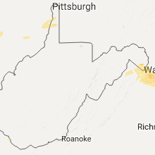
West Virginia
| Local Time | Report Details |
|---|---|
| 4:10 PM EDT | Multiple trees down in weirton in hancock county WV, 29.8 miles W of Pittsburgh, PA |
| 6:14 PM EDT | Quarter sized hail reported near Summit Point, WV, 71.4 miles W of Baltimore, MD |
Maryland
| Local Time | Report Details |
|---|---|
| 4:23 PM EDT | Small tree snapped along rt 17 in frederick county MD, 55.3 miles W of Baltimore, MD |
Pennsylvania
| Local Time | Report Details |
|---|---|
| 4:32 PM EDT | Two trees down in allegheny county PA, 12.2 miles WNW of Pittsburgh, PA |
| 6:22 PM EDT | Quarter sized hail reported near Glen Rock, PA, 34.3 miles N of Baltimore, MD, one inch hail between glen rock and shrewsbury |
| 6:32 PM EDT | Trees down rt. 219 at joy garden road in elk county PA, 68.5 miles NW of State College, PA |
Indiana
| Local Time | Report Details |
|---|---|
| 4:36 PM EDT | Reports of trees down on sr 19. also reports of trees downed on macy-gilead rd. trees look healthy... one is 3 ft in diameter... the others around 1-2 ft in diamete in miami county IN, 48.7 miles W of Fort Wayne, IN |
| 5:45 PM EDT | Quarter sized hail reported near Vincennes, IN, 39.5 miles N of Evansville, IN |
| 6:00 PM EDT | Reports of a tree down on s 675 w between beaver dam and silver lake... i in kosciusko county IN, 45 miles W of Fort Wayne, IN |
| 7:24 PM EDT | A couple of trees reported on houses... near intersection of cr 150 n and cr 450 e. numerous trees reported down in the nearby wooded are in cass county IN, 65.4 miles WSW of Fort Wayne, IN |
| 7:32 PM EDT | Healthy 2-3" limb downed at intersection of sr9 and 900 in huntington county IN, 21 miles WSW of Fort Wayne, IN |
| 7:57 PM EDT | Reports of several trees down around the peru... in area-and several lightning strikes. winds estimated at about 50 mph. approximately 1" of rain was measured as wel in miami county IN, 56.5 miles WSW of Fort Wayne, IN |
Georgia
| Local Time | Report Details |
|---|---|
| 4:39 PM EDT | A tree was blown down onto athens street near intersection of historic homer highwa in banks county GA, 61.8 miles SW of Greenville, SC |
Kansas
| Local Time | Report Details |
|---|---|
| 3:57 PM CDT | Quarter sized hail reported near Saint John, KS, 60.3 miles SSE of Hays, KS |
| 4:05 PM CDT | Quarter sized hail reported near Garfield, KS, 58.7 miles S of Hays, KS |
| 4:07 PM CDT | Half Dollar sized hail reported near Saint John, KS, 56 miles SSE of Hays, KS |
| 4:08 PM CDT | Golf Ball sized hail reported near Saint John, KS, 56.8 miles SSE of Hays, KS, via social media. |
| 4:09 PM CDT | Quarter sized hail reported near Saint John, KS, 59.6 miles SSE of Hays, KS, nickle to quarter size hail. |
| 4:16 PM CDT | Storm damage reported in comanche county KS, 58 miles N of Woodward, OK |
| 4:26 PM CDT | Quarter sized hail reported near Larned, KS, 47 miles S of Hays, KS |
| 4:38 PM CDT | Golf Ball sized hail reported near Great Bend, KS, 45.2 miles SE of Hays, KS, ping pong to golf ball sized hail |
| 4:41 PM CDT | Half Dollar sized hail reported near Great Bend, KS, 45.2 miles SE of Hays, KS |
| 4:43 PM CDT | Quarter sized hail reported near Great Bend, KS, 45.2 miles SE of Hays, KS |
| 4:43 PM CDT | Quarter sized hail reported near Ellinwood, KS, 55 miles ESE of Hays, KS, time is based off of radar. |
| 4:45 PM CDT | Half Dollar sized hail reported near Mullinville, KS, 79.8 miles N of Woodward, OK |
| 4:45 PM CDT | Quarter sized hail reported near Mount Hope, KS, 21.8 miles NW of Wichita, KS, via social media. delayed report. |
| 4:50 PM CDT | Golf Ball sized hail reported near Council Grove, KS, 36.5 miles S of Manhattan, KS |
| 4:53 PM CDT | Quarter sized hail reported near Council Grove, KS, 36.6 miles S of Manhattan, KS |
| 4:55 PM CDT | Quarter sized hail reported near Wilsey, KS, 36.9 miles S of Manhattan, KS |
| 5:05 PM CDT | Golf Ball sized hail reported near Halstead, KS, 24.8 miles NNW of Wichita, KS |
| 5:06 PM CDT | Estimated 65-70 mph wind in pratt county KS, 79.4 miles NNE of Woodward, OK |
| 5:06 PM CDT | Quarter sized hail reported near Junction City, KS, 23.6 miles SW of Manhattan, KS |
| 5:07 PM CDT | Golf Ball sized hail reported near Junction City, KS, 17.5 miles SW of Manhattan, KS |
| 5:08 PM CDT | Storm damage reported in pratt county KS, 84.4 miles W of Wichita, KS |
| 5:13 PM CDT | Storm damage reported in pratt county KS, 73.7 miles W of Wichita, KS |
| 5:14 PM CDT | Storm damage reported in pratt county KS, 68.8 miles W of Wichita, KS |
| 5:15 PM CDT | Estimated 65-70 mph wind gus in rush county KS, 32.3 miles SSE of Hays, KS |
| 5:15 PM CDT | Ping Pong Ball sized hail reported near Albert, KS, 32.3 miles SSE of Hays, KS |
| 5:17 PM CDT | Large tree branches broke in pratt county KS, 77 miles W of Wichita, KS |
| 5:18 PM CDT | Quarter sized hail reported near Holyrood, KS, 53.5 miles ESE of Hays, KS |
| 5:25 PM CDT | Golf Ball sized hail reported near Council Grove, KS, 28.3 miles S of Manhattan, KS |
| 5:30 PM CDT | Quarter sized hail reported near Kinsley, KS, 65 miles S of Hays, KS, social media photo. |
| 5:43 PM CDT | Ping Pong Ball sized hail reported near Ellsworth, KS, 64.1 miles ESE of Hays, KS |
| 5:45 PM CDT | Half Dollar sized hail reported near Albert, KS, 31.2 miles SSE of Hays, KS, several rounds of hail. pea to half dollar size. heavy rain. |
| 5:47 PM CDT | Golf Ball sized hail reported near Ellsworth, KS, 64.2 miles E of Hays, KS |
| 5:48 PM CDT | Hen Egg sized hail reported near Dodge City, KS, 49 miles ESE of Garden City, KS, via social media. |
| 5:52 PM CDT | Quarter sized hail reported near Dwight, KS, 20.6 miles S of Manhattan, KS |
| 5:52 PM CDT | Golf Ball sized hail reported near Ellis, KS, 13.2 miles WNW of Hays, KS |
| 5:54 PM CDT | Quarter sized hail reported near Dodge City, KS, 48.8 miles ESE of Garden City, KS |
| 5:55 PM CDT | Ping Pong Ball sized hail reported near Kanopolis, KS, 66 miles E of Hays, KS |
| 5:56 PM CDT | Quarter sized hail reported near Dodge City, KS, 48.4 miles ESE of Garden City, KS |
| 5:56 PM CDT | Half Dollar sized hail reported near Dodge City, KS, 49.7 miles ESE of Garden City, KS |
| 5:57 PM CDT | Quarter sized hail reported near Burdick, KS, 44.8 miles SSW of Manhattan, KS, via social media. |
| 5:57 PM CDT | Quarter sized hail reported near Dodge City, KS, 48.8 miles ESE of Garden City, KS, reported at 900th block of 5th ave... dodge city. |
| 5:58 PM CDT | Quarter sized hail reported near Dodge City, KS, 46.5 miles ESE of Garden City, KS |
| 5:58 PM CDT | Ping Pong Ball sized hail reported near Fowler, KS, 56.9 miles SE of Garden City, KS |
| 5:58 PM CDT | A power pole was knocked ove in reno county KS, 40.6 miles NW of Wichita, KS |
| 5:58 PM CDT | Hen Egg sized hail reported near Dodge City, KS, 46.5 miles ESE of Garden City, KS, holes in gutters as well. |
| 6:01 PM CDT | Emergency manager reports 60 to 65 mph wind in rice county KS, 65.7 miles NW of Wichita, KS |
| 6:03 PM CDT | Golf Ball sized hail reported near Alta Vista, KS, 21.6 miles S of Manhattan, KS, via social media. |
| 6:03 PM CDT | Hen Egg sized hail reported near Alta Vista, KS, 22.3 miles S of Manhattan, KS, via social media. |
| 6:06 PM CDT | Golf Ball sized hail reported near Alma, KS, 17.5 miles SSE of Manhattan, KS |
| 6:10 PM CDT | Half Dollar sized hail reported near Palco, KS, 22.5 miles NW of Hays, KS |
| 6:10 PM CDT | Quarter sized hail reported near Alta Vista, KS, 22.3 miles S of Manhattan, KS, radar estimated. delayed report. |
| 6:11 PM CDT | Quarter sized hail reported near Abilene, KS, 39.2 miles WSW of Manhattan, KS, nickels to quarter sized hail. |
| 6:11 PM CDT | Reports of at least one gust to 60 mp in dickinson county KS, 35.7 miles WSW of Manhattan, KS |
| 6:13 PM CDT | Semi was blown over on united states highway 56. time is estimated from rada in rice county KS, 63 miles NW of Wichita, KS |
| 6:15 PM CDT | Shingles torn off house... 8-10 inch limbs blown down and damaged house... tin roof torn off she in dickinson county KS, 31 miles WSW of Manhattan, KS |
| 6:18 PM CDT | Ping Pong Ball sized hail reported near Palco, KS, 29.1 miles NNW of Hays, KS, ping pong size initially to quarters to pea sized hail. |
| 6:21 PM CDT | Emergency manager reports damage to small sheds on the south side of the city and branches of 1.5 to 2 feet in diameter have fallen down. multiple power lines are down in harvey county KS, 24.3 miles N of Wichita, KS |
| 6:21 PM CDT | Storm damage reported in harvey county KS, 26 miles N of Wichita, KS |
| 6:21 PM CDT | Winds of 60 mph reported at mile post 250 on interstate 7 in saline county KS, 62.1 miles WSW of Manhattan, KS |
| 6:26 PM CDT | Storm damage reported in saline county KS, 63.6 miles WSW of Manhattan, KS |
| 6:32 PM CDT | Tremendous tree damage with two foot diameter trees uprooted. all of the shingles were blown off of a house. several power poles were down and blocking roadways. time i in saline county KS, 65.9 miles WSW of Manhattan, KS |
| 6:38 PM CDT | Along interstate 70 at mm25 in saline county KS, 60.1 miles WSW of Manhattan, KS |
| 6:39 PM CDT | Ping Pong Ball sized hail reported near Paxico, KS, 26.1 miles ESE of Manhattan, KS |
| 6:44 PM CDT | Quarter sized hail reported near Wakeeney, KS, 28.6 miles W of Hays, KS |
| 6:45 PM CDT | Golf Ball sized hail reported near Maple Hill, KS, 29.2 miles ESE of Manhattan, KS |
| 6:46 PM CDT | Southeast side of town at webb and 119t in sedgwick county KS, 15.2 miles SSE of Wichita, KS |
| 6:51 PM CDT | 50 to 60 mp in butler county KS, 13.9 miles SE of Wichita, KS |
| 6:58 PM CDT | Quarter sized hail reported near Topeka, KS, 44.6 miles ESE of Manhattan, KS |
| 6:58 PM CDT | Quarter sized hail reported near Topeka, KS, 45 miles ESE of Manhattan, KS |
| 7:00 PM CDT | Ping Pong Ball sized hail reported near Topeka, KS, 44.4 miles E of Manhattan, KS |
| 7:01 PM CDT | Ping Pong Ball sized hail reported near Topeka, KS, 43.9 miles ESE of Manhattan, KS |
| 7:01 PM CDT | Ping Pong Ball sized hail reported near Topeka, KS, 45.9 miles E of Manhattan, KS, i 70 and gage. |
| 7:03 PM CDT | Quarter sized hail reported near Topeka, KS, 44.3 miles ESE of Manhattan, KS |
| 7:03 PM CDT | Tree down (6-8 inches in diameter) time estimated rada in jefferson county KS, 50.4 miles W of Kansas City, MO |
| 7:06 PM CDT | Quarter sized hail reported near Topeka, KS, 45.9 miles E of Manhattan, KS, 46th and button road. |
| 7:15 PM CDT | Quarter sized hail reported near Maple Hill, KS, 27.6 miles ESE of Manhattan, KS |
| 7:53 PM CDT | Quarter sized hail reported near Paxico, KS, 26.1 miles ESE of Manhattan, KS, also reported small tree limbs down. |
| 7:55 PM CDT | Quarter sized hail reported near Kinsley, KS, 65 miles S of Hays, KS |
| 7:55 PM CDT | Quarter sized hail reported near Hoyt, KS, 47.5 miles E of Manhattan, KS |
| 7:57 PM CDT | Trees down. time estimated based on rada in jefferson county KS, 54.3 miles ENE of Manhattan, KS |
| 8:03 PM CDT | Ping Pong Ball sized hail reported near Valley Falls, KS, 50 miles WNW of Kansas City, MO |
| 8:07 PM CDT | Semi truck and trailer blown over at k4 and k1 in jefferson county KS, 49.3 miles WNW of Kansas City, MO |
| 8:07 PM CDT | Multiple tree limbs down (4 inch diameter). also report of quarter size hai in jefferson county KS, 47.8 miles WNW of Kansas City, MO |
| 8:07 PM CDT | 6-10 inch diameter tree limbs blown down on power lines. power out in valley fall in jefferson county KS, 49.8 miles WNW of Kansas City, MO |
| 8:08 PM CDT | Storm damage reported in greenwood county KS, 52.9 miles ENE of Wichita, KS |
| 8:09 PM CDT | Ping Pong Ball sized hail reported near Valley Falls, KS, 50.8 miles WNW of Kansas City, MO |
| 8:11 PM CDT | Quarter sized hail reported near Denison, KS, 52 miles ENE of Manhattan, KS |
| 8:25 PM CDT | Emergency manager reports power lines are down with minor tree damage. there is a power outage city wide. time is based off of rada in greenwood county KS, 43.8 miles WNW of Chanute, KS |
| 8:31 PM CDT | Ping Pong Ball sized hail reported near Effingham, KS, 52.4 miles WNW of Kansas City, MO |
| 8:35 PM CDT | Quarter sized hail reported near Olathe, KS, 18.2 miles SW of Kansas City, MO |
| 8:36 PM CDT | Quarter sized hail reported near De Soto, KS, 22.6 miles WSW of Kansas City, MO |
| 8:45 PM CDT | Quarter sized hail reported near Lenexa, KS, 17.6 miles WSW of Kansas City, MO |
| 8:50 PM CDT | Golf Ball sized hail reported near Lenexa, KS, 17.8 miles WSW of Kansas City, MO, via photo on social media at 79th and mize in western shawnee |
| 8:59 PM CDT | Quarter sized hail reported near Bonner Springs, KS, 16.2 miles W of Kansas City, MO |
| 9:00 PM CDT | Golf Ball sized hail reported near Kansas City, KS, 12.5 miles WNW of Kansas City, MO |
| 9:07 PM CDT | Quarter sized hail reported near Paola, KS, 39.3 miles SSW of Kansas City, MO |
| 9:15 PM CDT | Half Dollar sized hail reported near Kansas City, KS, 13.3 miles WNW of Kansas City, MO, covering the ground |
| 9:19 PM CDT | Home anemometer measured peak gust of 65 mp in osage county KS, 56.4 miles WSW of Kansas City, MO |
| 9:20 PM CDT | Tennis Ball sized hail reported near Bonner Springs, KS, 15.4 miles W of Kansas City, MO |
| 9:22 PM CDT | Photo received via social media showing a 4 inch diameter limb snapped off a tre in jackson county KS, 51.3 miles ENE of Manhattan, KS |
| 9:34 PM CDT | Officer noted small tree branches and other light debris noted in wind gust in franklin county KS, 49.1 miles WSW of Kansas City, MO |
| 9:39 PM CDT | 3-4 inch diameter limbs dow in douglas county KS, 43.2 miles WSW of Kansas City, MO |
| 9:44 PM CDT | Storm damage reported in douglas county KS, 43.1 miles WSW of Kansas City, MO |
| 9:50 PM CDT | Estimated winds up to 60 mp in douglas county KS, 38.1 miles WSW of Kansas City, MO |
| 9:52 PM CDT | Near 23rd and alabam in douglas county KS, 37.6 miles WSW of Kansas City, MO |
| 9:58 PM CDT | Power lines dow in jefferson county KS, 45.6 miles WNW of Kansas City, MO |
| 10:00 PM CDT | 4 inch tree limb dow in douglas county KS, 37.6 miles WSW of Kansas City, MO |
| 10:04 PM CDT | Trees uprooted in johnson county KS, 22.5 miles WSW of Kansas City, MO |
| 10:07 PM CDT | Measured at kixd new century airport in johnson county KS, 25.1 miles SW of Kansas City, MO |
| 10:09 PM CDT | Storm damage reported in johnson county KS, 16.3 miles WSW of Kansas City, MO |
Virginia
| Local Time | Report Details |
|---|---|
| 5:12 PM EDT | Thunderstorm winds downed two trees along buck horn road... temporarily closing the roadwa in carroll county VA, 52.7 miles SW of Roanoke, VA |
| 6:12 PM EDT | Quarter sized hail reported near Strasburg, VA, 80.2 miles E of Elkins, WV |
| 7:42 PM EDT | Quarter sized hail reported near Aldie, VA, 57.1 miles WSW of Baltimore, MD |
| 7:42 PM EDT | Quarter sized hail reported near Chantilly, VA, 55.2 miles WSW of Baltimore, MD |
| 7:57 PM EDT | Quarter sized hail reported near Gainesville, VA, 62.8 miles WSW of Baltimore, MD |
| 8:24 PM EDT | Forest park high school in prince william county VA, 62.3 miles SW of Baltimore, MD |
| 8:30 PM EDT | Trees down in several locations of prince william county between 815-845 pm...including woodbridge...dumfries haymarke in prince william county VA, 56.9 miles SW of Baltimore, MD |
Vermont
| Local Time | Report Details |
|---|---|
| 5:25 PM EDT | Storm damage reported in chittenden county VT, 3.1 miles E of Burlington, VT |
| 5:25 PM EDT | Multiple reports of small trees down and minor property daamag in chittenden county VT, 2.2 miles E of Burlington, VT |
| 5:28 PM EDT | Quarter sized hail reported near Williston, VT, 6.3 miles ESE of Burlington, VT |
| 5:33 PM EDT | Tree down blocking highway 2 in chittenden county VT, 6.6 miles ESE of Burlington, VT |
| 5:40 PM EDT | Trees and powerlines down in essex county VT, 82 miles E of Burlington, VT |
| 5:48 PM EDT | Tractor trailer blown ove in orleans county VT, 54.4 miles ENE of Burlington, VT |
| 5:49 PM EDT | Trees dwon blocking train tracks in orleans county VT, 54.4 miles ENE of Burlington, VT |
| 5:50 PM EDT | Trees adn powerlines down in essex county VT, 72.5 miles ENE of Burlington, VT |
| 5:55 PM EDT | Trees down in caledonia county VT, 63.4 miles E of Burlington, VT |
| 6:10 PM EDT | Trees and powerlines down in essex county VT, 82 miles E of Burlington, VT |
| 6:18 PM EDT | House knocked off of foundation on potash bay r in addison county VT, 28.7 miles SSW of Burlington, VT |
| 6:27 PM EDT | Quarter sized hail reported near Vergennes, VT, 27 miles S of Burlington, VT |
| 7:45 PM EDT | Huge trees down in backyard in orange county VT, 57 miles ESE of Burlington, VT |
| 8:03 PM EDT | Storm damage reported in rutland county VT, 56.2 miles NE of Schenectady, NY |
New Hampshire
| Local Time | Report Details |
|---|---|
| 5:40 PM EDT | Trees and powerlines down in essex county VT, 80.3 miles ENE of Burlington, VT |
| 8:28 PM EDT | Trees and wires down in grafton county NH, 65.1 miles ESE of Burlington, VT |
| 8:28 PM EDT | Trees and wires down in grafton county NH, 70.1 miles ESE of Burlington, VT |
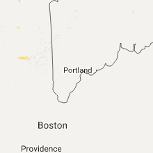
| 8:31 PM EDT | Quarter size hail in grafton county NH, 75.8 miles WNW of Portland, ME |
| 8:51 PM EDT | Trees and wires down in grafton county NH, 65 miles ESE of Burlington, VT |
| 8:54 PM EDT | Trees and wires down on route 3 in coos county NH, 81.2 miles E of Burlington, VT |
| 8:54 PM EDT | Trees down in grafton county NH, 68.9 miles ESE of Burlington, VT |
| 9:00 PM EDT | Trees and wires down on route 12 in cheshire county NH, 78.8 miles ENE of Schenectady, NY |
| 9:05 PM EDT | Trees down river rd and rt 12 in cheshire county NH, 76.9 miles E of Schenectady, NY |
| 9:06 PM EDT | Trees down in cheshire county NH, 78.8 miles ENE of Schenectady, NY |
| 9:10 PM EDT | Trees and wires down in cheshire county NH, 79.4 miles E of Schenectady, NY |
| 9:10 PM EDT | Trees and wires down in cheshire county NH, 83.4 miles ENE of Schenectady, NY |
| 9:15 PM EDT | Trees down court st and rt 12a in cheshire county NH, 83.8 miles E of Schenectady, NY |
| 9:15 PM EDT | Trees and wires down rt 12a in cheshire county NH, 83.5 miles E of Schenectady, NY |
| 9:19 PM EDT | Trees ad wires down in cheshire county NH, 84.5 miles E of Schenectady, NY |
| 9:20 PM EDT | Trees and wires dow in cheshire county NH, 90.8 miles ENE of Schenectady, NY |
| 9:27 PM EDT | Trees and wires down... trees blocking various roads in grafton county NH, 65.1 miles ESE of Burlington, VT |
| 9:27 PM EDT | Trees and wires down trees across various roads in grafton county NH, 72.4 miles E of Burlington, VT |
| 9:27 PM EDT | Trees and wires down... trees blocking various roads in grafton county NH, 60.4 miles ESE of Burlington, VT |
| 9:35 PM EDT | Large branches down in carroll county NH, 55.2 miles NW of Portland, ME |
| 9:37 PM EDT | Trees down in cheshire county NH, 70.9 miles NNW of Providence, RI |
| 10:05 PM EDT | Multiple reports of trees down all over town in hillsborough county NH, 78.8 miles WSW of Portland, ME |
| 10:15 PM EDT | Trees and wires down in rockingham county NH, 71.5 miles SW of Portland, ME |
Illinois
| Local Time | Report Details |
|---|---|
| 5:12 PM CDT | Quarter sized hail reported near Benton, IL, 58.1 miles NE of Cape Girardeau, MO, mostly dime sized hail... with a few quarter sized pieces. |
| 10:45 PM CDT | Quarter sized hail reported near Ivesdale, IL, 32.6 miles N of Mattoon, IL, report relayed by wand-tv |
| 5:39 AM CDT | 6 to 10 foot tall tree blown over...power out around tow in madison county IL, 17.3 miles NNE of Saint Louis, MO |
| 5:47 AM CDT | Storm damage reported in macoupin county IL, 34.9 miles NNE of Saint Louis, MO |
| 6:06 AM CDT | Two 80 by 30 foot storage sheds were destroye in macoupin county IL, 57.3 miles NNE of Saint Louis, MO |
Massachusetts
| Local Time | Report Details |
|---|---|
| 9:20 PM EDT | Tree down on hubbard hill road. road blocke in franklin county MA, 73.3 miles ESE of Schenectady, NY |
| 9:55 PM EDT | Trees down in a few location in worcester county MA, 60.4 miles NNW of Providence, RI |
| 10:00 PM EDT | Tree down blocking east road near leno par in worcester county MA, 56 miles NNW of Providence, RI |
| 10:20 PM EDT | Large branch down on high tension wire on mohagony ru in worcester county MA, 51.4 miles NNW of Providence, RI |
| 10:38 PM EDT | Tree down on west street at varnai stree in essex county MA, 63 miles N of Providence, RI |
| 10:38 PM EDT | Tree down on pleasant valley roa in essex county MA, 64.8 miles SSW of Portland, ME |
| 10:42 PM EDT | Tree down on greenville stree in middlesex county MA, 50.6 miles N of Providence, RI |
| 10:42 PM EDT | Tree down on pleasant stree in middlesex county MA, 56.5 miles N of Providence, RI |
| 10:42 PM EDT | Multiple trees down on prospect stree in essex county MA, 68.4 miles SSW of Portland, ME |
| 10:43 PM EDT | Tree down on pike stree in middlesex county MA, 55.7 miles N of Providence, RI |
| 10:45 PM EDT | Tree down across roadway on county road by river ben in essex county MA, 66.2 miles NNE of Providence, RI |
| 10:45 PM EDT | Trees and wires down on crestline circle in essex county MA, 56.7 miles NNE of Providence, RI |
| 10:55 PM EDT | Tree fell on house on whittier street in essex county MA, 68 miles NNE of Providence, RI |
| 10:55 PM EDT | Wires down on jeffferson street in essex county MA, 61.8 miles NNE of Providence, RI |
| 10:55 PM EDT | Tree down on wires on lynn street at bowen road in essex county MA, 53.8 miles NNE of Providence, RI |
| 11:00 PM EDT | Tree down on street lights on curtis avenue and morton ave in essex county MA, 48.9 miles NNE of Providence, RI |
Maine
| Local Time | Report Details |
|---|---|
| 9:40 PM EDT | Tree across route 1a. time estimated from radar in aroostook county ME, 17.9 miles NE of Caribou, ME |
| 9:57 PM EDT | 2 trees dow in aroostook county ME, 26.1 miles NNW of Caribou, ME |
Missouri
| Local Time | Report Details |
|---|---|
| 9:22 PM CDT | Half Dollar sized hail reported near Kansas City, MO, 12.9 miles NW of Kansas City, MO |
| 9:27 PM CDT | Quarter sized hail reported near Kansas City, MO, 11.3 miles NNW of Kansas City, MO |
| 9:35 PM CDT | Quarter sized hail reported near Platte City, MO, 20.6 miles NNW of Kansas City, MO |
| 9:38 PM CDT | Quarter sized hail reported near Platte City, MO, 19.5 miles NNW of Kansas City, MO, n highway and 136th |
| 9:55 PM CDT | Golf Ball sized hail reported near Smithville, MO, 19.8 miles N of Kansas City, MO |
| 9:56 PM CDT | Quarter sized hail reported near Smithville, MO, 19.1 miles N of Kansas City, MO, buckets of hail were falling |
| 10:14 PM CDT | Measured at kmci in platte county MO, 15.4 miles NNW of Kansas City, MO |
| 10:25 PM CDT | From social media in platte county MO, 11.3 miles NNW of Kansas City, MO |
| 10:30 PM CDT | Storm damage reported in clay county MO, 10.4 miles NNE of Kansas City, MO |
| 10:33 PM CDT | Storm damage reported in clay county MO, 10.8 miles N of Kansas City, MO |
| 10:37 PM CDT | Storm damage reported in clay county MO, 12.9 miles NE of Kansas City, MO |
| 10:47 PM CDT | 4-6 inch diameter branches snapped off of healthy oak trees in jackson county MO, 15.5 miles ESE of Kansas City, MO |
| 10:48 PM CDT | Large hardwood trees bent horizontally in clay county MO, 13.4 miles NE of Kansas City, MO |
| 10:50 PM CDT | 6-7inch tree branches down in jackson county MO, 8.8 miles E of Kansas City, MO |
| 12:51 AM CDT | Relayed report from fire dept. large tree blocking farm road 1100 near farm road 220 in barry county MO, 51.4 miles SW of Springfield, MO |
| 1:04 AM CDT | Report of docks damaged and boats upside down in the water on farm road 1252. tree damage was also reporte in barry county MO, 45.3 miles SSW of Springfield, MO |
| 1:10 AM CDT | Trees reported down on highway 39 north of farm road 213 in barry county MO, 39.1 miles SSW of Springfield, MO |
| 1:27 AM CDT | A powerline was reported down on highway 413 across from the reeds spring high schoo in stone county MO, 32 miles S of Springfield, MO |
| 1:30 AM CDT | *** 1 inj *** relayed report from leo... shingles blown of the camden hotel. fence blown down near the tanger mall. one person reported with a head injury at the camden in taney county MO, 39.3 miles S of Springfield, MO |
| 1:36 AM CDT | Report of 6 " diameter tree down on cox road across from wanda gray elementar in greene county MO, 6.3 miles SSW of Springfield, MO |
| 1:39 AM CDT | Reports of multiple power lines and trees dow in taney county MO, 35.2 miles SSE of Springfield, MO |
| 1:39 AM CDT | 40 inch diameter tree down at 137 lotus in rockaway beach. time estimated via rada in taney county MO, 35.8 miles SSE of Springfield, MO |
| 1:40 AM CDT | Reports of limbs from 3 to 4 inches in diameter on the roa in taney county MO, 38 miles SSE of Springfield, MO |
| 1:46 AM CDT | A large tree was reported down across highway 7 in taney county MO, 35.6 miles SSE of Springfield, MO |
| 1:47 AM CDT | Numerous trees reported down on hulls ford roa in taney county MO, 35.6 miles SSE of Springfield, MO |
| 1:47 AM CDT | Roof damage reported to home in taney county MO, 35.2 miles SSE of Springfield, MO |
| 1:48 AM CDT | Roof damage reported to home in taney county MO, 35.4 miles SSE of Springfield, MO |
| 1:54 AM CDT | Trees blown onto two homes causing damag in greene county MO, 7.7 miles ESE of Springfield, MO |
| 1:56 AM CDT | Large tree reported down near the intersection of state highway d and highway 12 in greene county MO, 7.5 miles ESE of Springfield, MO |
| 1:57 AM CDT | Multiple trees were reported down in the 6400 block of east skyline drive and ridgeline blocking road in greene county MO, 7.5 miles ESE of Springfield, MO |
| 2:00 AM CDT | A tree was blown onto a home causing significant roof damag in christian county MO, 23.4 miles SE of Springfield, MO |
| 2:02 AM CDT | Reports of trees down from dd highway south of goodhope close to plainview schoo in douglas county MO, 35.4 miles SE of Springfield, MO |
| 2:09 AM CDT | Two very large oak trees reported down on 194 leming road at the douglas and christian county lin in christian county MO, 26 miles ESE of Springfield, MO |
| 2:20 AM CDT | A large tree was reported down on the roa in douglas county MO, 38.7 miles ESE of Springfield, MO |
| 2:20 AM CDT | 80 foot tall tree with 4 foot circumference at base fell taking out power poles and power lines. lots of 7 to 10 inch limbs down on trailer house. numerous 4 to 6 inch in webster county MO, 13.3 miles E of Springfield, MO |
| 2:28 AM CDT | Large limb reported down on car on highway in douglas county MO, 49.3 miles ESE of Springfield, MO |
| 3:12 AM CDT | A few large limbs reported dow in miller county MO, 43.6 miles SSW of Columbia, MO |
| 3:15 AM CDT | Quarter sized hail reported near Jefferson City, MO, 27.5 miles SSE of Columbia, MO |
| 3:50 AM CDT | Storm damage reported in maries county MO, 35.5 miles NNW of Salem, MO |
| 4:04 AM CDT | Large tree blown down onto u.s. highway 5 in osage county MO, 40.8 miles SE of Columbia, MO |
| 4:13 AM CDT | Numerous trees uprooted and snapped in half in gasconade county MO, 49.2 miles N of Salem, MO |
| 4:13 AM CDT | Semi blown over on interstate 70 west of danvill in montgomery county MO, 38.7 miles E of Columbia, MO |
| 4:17 AM CDT | Large tree branch blown down and pea size hai in callaway county MO, 34.2 miles E of Columbia, MO |
| 4:39 AM CDT | Storm damage reported in montgomery county MO, 44.4 miles E of Columbia, MO |
| 5:00 AM CDT | Couple of trees uprooted and several large tree limbs blown dow in st. louis county MO, 25.4 miles WSW of Saint Louis, MO |
| 5:17 AM CDT | Several tree limbs blown dow in st. louis county MO, 7.6 miles WNW of Saint Louis, MO |
| 5:19 AM CDT | Storm damage reported in st. louis county MO, 13 miles NW of Saint Louis, MO |
Connecticut
| Local Time | Report Details |
|---|---|
| 11:55 PM EDT | Several trees down in litchfield county CT, 75.7 miles NNE of Brooklyn, NY |
Arkansas
| Local Time | Report Details |
|---|---|
| 11:45 PM CDT | Tree limbs down on west side of siloam spring in benton county AR, 55.9 miles N of Fort Smith, AR |
| 12:05 AM CDT | Storm damage reported in sebastian county AR, 14.7 miles SE of Fort Smith, AR |
| 12:14 AM CDT | Tree damaged at the bentonville municipal airport in benton county AR, 69 miles N of Fort Smith, AR |
| 12:15 AM CDT | Storm damage reported in benton county AR, 69 miles N of Fort Smith, AR |
| 12:20 AM CDT | Shingles blown off a home. time estimated from rada in washington county AR, 57.9 miles NNE of Fort Smith, AR |
| 12:30 AM CDT | Numerous reports of trees and power lines down throughout franklin count in franklin county AR, 34.1 miles ENE of Fort Smith, AR |
| 1:11 AM CDT | Lots of trees and powerlines were down in the western half of johnson count in johnson county AR, 51.6 miles ENE of Fort Smith, AR |
| 1:15 AM CDT | Lots of trees were down along with a few power line in newton county AR, 77.5 miles ENE of Fort Smith, AR |
Connect with Interactive Hail Maps