

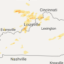
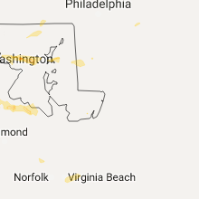
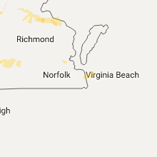
Hail Map for Friday, May 19, 2017

Number of Impacted Households on 5/19/2017
0
Impacted by 1" or Larger Hail
0
Impacted by 1.75" or Larger Hail
0
Impacted by 2.5" or Larger Hail
Square Miles of Populated Area Impacted on 5/19/2017
0
Impacted by 1" or Larger Hail
0
Impacted by 1.75" or Larger Hail
0
Impacted by 2.5" or Larger Hail


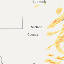
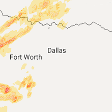
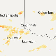


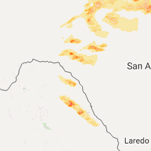


Cities Most Affected by Hail Storms of 5/19/2017
| Hail Size | Demographics of Zip Codes Affected | ||||||
|---|---|---|---|---|---|---|---|
| City | Count | Average | Largest | Pop Density | House Value | Income | Age |
| Santa Anna, TX | 1 | 4.50 | 4.50 | 4 | $33k | $23.3k | 43.9 |
| Burkburnett, TX | 2 | 2.13 | 2.50 | 148 | $64k | $38.5k | 38.2 |
| Brownwood, TX | 2 | 1.75 | 1.75 | 66 | $47k | $29.1k | 38.0 |
| Sweetwater, TX | 2 | 1.75 | 1.75 | 44 | $37k | $26.3k | 38.7 |
| Hico, TX | 2 | 1.75 | 1.75 | 10 | $51k | $31.3k | 43.4 |
| Paint Rock, TX | 1 | 2.75 | 2.75 | 1 | $58k | $34.1k | 48.5 |
| Bloomington, IN | 1 | 2.00 | 2.00 | 434 | $100k | $31.1k | 30.4 |
| Tishomingo, OK | 1 | 1.75 | 1.75 | 28 | $47k | $24.6k | 37.4 |
| Olney, TX | 1 | 1.75 | 1.75 | 15 | $34k | $25.4k | 42.7 |
| Salem, AR | 1 | 1.75 | 1.75 | 17 | $50k | $23.7k | 46.1 |
| Menard, TX | 1 | 1.75 | 1.75 | 1 | $30k | $23.1k | 49.4 |
| Purmela, TX | 1 | 1.75 | 1.75 | 6 | $49k | $25.9k | 43.5 |
| Depauw, IN | 1 | 1.75 | 1.75 | 42 | $79k | $38.6k | 40.9 |
| Reidsville, NC | 1 | 1.75 | 1.75 | 154 | $86k | $34.3k | 42.2 |
| Moneta, VA | 1 | 1.75 | 1.75 | 129 | $172k | $42.0k | 50.3 |
| Aspermont, TX | 1 | 1.75 | 1.75 | 1 | $31k | $27.0k | 46.1 |
| Spencer, IN | 1 | 1.75 | 1.75 | 76 | $90k | $37.4k | 42.4 |
| Wapello, IA | 1 | 1.75 | 1.75 | 30 | $70k | $38.1k | 41.8 |
Hail and Wind Damage Spotted on 5/19/2017
Filter by Report Type:Hail ReportsWind Reports
States Impacted
Texas, Kentucky, Kansas, Virginia, North Carolina, Ohio, Indiana, Pennsylvania, Tennessee, Missouri, Oklahoma, Arkansas, Iowa, Maryland, West VirginiaTexas
| Local Time | Report Details |
|---|---|
| 7:05 AM CDT | Storm damage reported in throckmorton county TX, 55.8 miles NE of Abilene, TX |
| 7:20 AM CDT | Downed utility lines just south and west of ivan. time estimated via rada in stephens county TX, 65.7 miles ENE of Abilene, TX |
| 9:10 AM CDT | Golf Ball sized hail reported near Sweetwater, TX, 39.1 miles W of Abilene, TX |
| 9:15 AM CDT | Golf Ball sized hail reported near Sweetwater, TX, 39.1 miles W of Abilene, TX |
| 9:45 AM CDT | Quarter sized hail reported near Roscoe, TX, 55.2 miles W of Abilene, TX |
| 11:00 AM CDT | Quarter sized hail reported near Throckmorton, TX, 60 miles NNE of Abilene, TX |
| 11:02 AM CDT | Ping Pong Ball sized hail reported near Throckmorton, TX, 60 miles NNE of Abilene, TX |
| 1:31 PM CDT | Quarter sized hail reported near Olney, TX, 42.8 miles SSW of Wichita Falls, TX, storm spotter report quarter size hail 4 miles sse of olney. |
| 1:35 PM CDT | Half Dollar sized hail reported near Olney, TX, 41.9 miles SSW of Wichita Falls, TX, storm spotter report half dollar size hail 2 miles sse of olney |
| 1:40 PM CDT | Golf Ball sized hail reported near Olney, TX, 40.2 miles SSW of Wichita Falls, TX, golf ball size hail report near olney |
| 2:12 PM CDT | Quarter sized hail reported near Windthorst, TX, 22.9 miles S of Wichita Falls, TX, nickel to quarter size hail reported at the windhorst general store |
| 2:24 PM CDT | Quarter sized hail reported near Henrietta, TX, 27.3 miles SSE of Wichita Falls, TX |
| 2:37 PM CDT | Quarter sized hail reported near Seymour, TX, 44.1 miles WSW of Wichita Falls, TX |
| 3:24 PM CDT | Quarter sized hail reported near San Angelo, TX, 82.1 miles SW of Abilene, TX, quarter hail at nws |
| 3:25 PM CDT | Half Dollar sized hail reported near San Angelo, TX, 82.1 miles SW of Abilene, TX |
| 3:38 PM CDT | Quarter sized hail reported near Burkburnett, TX, 13.1 miles NNW of Wichita Falls, TX |
| 3:43 PM CDT | Ping Pong Ball sized hail reported near Burkburnett, TX, 14.1 miles N of Wichita Falls, TX |
| 3:44 PM CDT | Golf Ball sized hail reported near Burkburnett, TX, 12.3 miles NNW of Wichita Falls, TX |
| 3:45 PM CDT | Tennis Ball sized hail reported near Burkburnett, TX, 12.3 miles NNW of Wichita Falls, TX, public reported tennis ball sized hail. picture on facebook. |
| 3:45 PM CDT | Large tree limbs down. resident lost 3 windows due to hail and tree limbs. also... major hail damage to vehicle in wichita county TX, 13 miles NNW of Wichita Falls, TX |
| 4:58 PM CDT | Quarter sized hail reported near San Angelo, TX, 83.4 miles SSW of Abilene, TX |
| 6:25 PM CDT | Baseball sized hail reported near Paint Rock, TX, 65.1 miles S of Abilene, TX, observed in paint rock. |
| 6:40 PM CDT | Storm damage reported in stonewall county TX, 61.2 miles NW of Abilene, TX |
| 6:55 PM CDT | Golf Ball sized hail reported near Aspermont, TX, 55.2 miles NNW of Abilene, TX |
| 7:00 PM CDT | Golf Ball sized hail reported near Purmela, TX, 28.9 miles NNW of Killeen, TX |
| 7:05 PM CDT | Golf Ball sized hail reported near Hico, TX, 60.6 miles NNW of Killeen, TX, golf ball size hail report 1 mile south of carlton. |
| 7:12 PM CDT | Quarter sized hail reported near Jonesboro, TX, 41.6 miles NNW of Killeen, TX, spotter report quarter size hail 6 miles w of cranfills gap |
| 7:24 PM CDT | Quarter sized hail reported near Hico, TX, 58.2 miles NNW of Killeen, TX |
| 7:26 PM CDT | Softball sized hail reported near Santa Anna, TX, 56.7 miles SSE of Abilene, TX, softball size hail reported |
| 7:28 PM CDT | Golf Ball sized hail reported near Hico, TX, 62.1 miles NNW of Killeen, TX |
| 7:32 PM CDT | Half Dollar sized hail reported near Miles, TX, 71.4 miles SSW of Abilene, TX, half dollar reported in mareta. |
| 8:02 PM CDT | Quarter sized hail reported near Bangs, TX, 62.9 miles SE of Abilene, TX, quarter size hail reported |
| 8:15 PM CDT | Golf Ball sized hail reported near Brownwood, TX, 67.6 miles SE of Abilene, TX, golf ball size haill reported |
| 8:17 PM CDT | Quarter sized hail reported near Hico, TX, 48.6 miles NNW of Killeen, TX, volunteer fire department report quarter size hail near cranfills gap |
| 8:25 PM CDT | Golf Ball sized hail reported near Brownwood, TX, 66.8 miles SE of Abilene, TX, emergency manager reports golf ball sized hail just north of brownwood. also had a wind gust of 55 mph. |
| 8:56 PM CDT | Quarter sized hail reported near Christoval, TX, 100.8 miles SSW of Abilene, TX, nws employee reported quarter sized hail 4 miles sw of christoval |
| 11:09 PM CDT | Quarter sized hail reported near Wolfforth, TX, 13.8 miles SW of Lubbock, TX |
| 11:10 PM CDT | Weather station just east of oak trail shores recorded 60 mph wind gust in hood county TX, 61.9 miles WSW of Dallas, TX |
| 11:22 PM CDT | Quarter sized hail reported near Lubbock, TX, 8.7 miles SW of Lubbock, TX |
| 11:25 PM CDT | Quarter sized hail reported near Lubbock, TX, 9.2 miles SW of Lubbock, TX |
| 11:34 PM CDT | Delayed report: lampasas pd reports several trees downed in the cit in lampasas county TX, 27 miles W of Killeen, TX |
| 11:36 PM CDT | Golf Ball sized hail reported near Menard, TX, 105.4 miles S of Abilene, TX, .sherriffs office reports golf ball sized hail in menard |
Kentucky
| Local Time | Report Details |
|---|---|
| 8:55 AM EDT | Trees and power lines dow in pulaski county KY, 51.7 miles SW of Irvine, KY |
| 9:40 AM EDT | Large tree limb downed. estimated wind gust of 40 mp in laurel county KY, 39.7 miles S of Irvine, KY |
| 4:35 PM EDT | Quarter sized hail reported near Crittenden, KY, 23.2 miles SSW of Cincinnati, OH |
| 4:07 PM CDT | Quarter sized hail reported near Hartford, KY, 50.2 miles SE of Evansville, IN |
| 4:36 PM CDT | Large tree limbs down and pea size hai in hancock county KY, 49.4 miles ESE of Evansville, IN |
| 9:40 PM EDT | Half Dollar sized hail reported near Rogers, KY, 18.5 miles E of Irvine, KY |
| 9:42 PM EDT | A tree was reported to have been downe in breathitt county KY, 31 miles ESE of Irvine, KY |
| 10:20 PM EDT | Large limb down on richmond st. north of downtow in rockcastle county KY, 29.8 miles SW of Irvine, KY |
| 10:39 PM EDT | Tree down near mile marker 23 on highway 3 in breathitt county KY, 39.7 miles ESE of Irvine, KY |
| 10:40 PM EDT | Quarter sized hail reported near Prestonsburg, KY, 56.7 miles E of Irvine, KY |
| 10:42 PM EDT | A tree was reported to have been downe in breathitt county KY, 31 miles ESE of Irvine, KY |
| 10:44 PM EDT | Tree down around mile marker 2 on ky 11 in floyd county KY, 64.5 miles E of Irvine, KY |
Kansas
| Local Time | Report Details |
|---|---|
| 10:50 AM CDT | Delayed report. road sign blown dow in harper county KS, 47.6 miles SW of Wichita, KS |
| 4:50 PM CDT | Storm damage reported in reno county KS, 56.9 miles WNW of Wichita, KS |
| 5:35 PM CDT | Delayed report. nine-inch diameter tree limb down west side of hutchinso in reno county KS, 41 miles NW of Wichita, KS |
| 6:02 PM CDT | Storm damage reported in reno county KS, 39.2 miles NW of Wichita, KS |
| 7:00 PM CDT | Delayed report. time estimated from rada in harvey county KS, 24.3 miles N of Wichita, KS |
Virginia
| Local Time | Report Details |
|---|---|
| 11:59 AM EDT | One tree down along muse field road in franklin county VA, 18.9 miles SSE of Roanoke, VA |
| 12:03 PM EDT | One tree down at the intersection of chestnut hill road and washboard road in franklin county VA, 19.2 miles SSE of Roanoke, VA |
| 1:03 PM EDT | Thunderstorm winds resulted in a downed tree across falling creek roa in bedford county VA, 27.6 miles E of Roanoke, VA |
| 1:06 PM EDT | Quarter sized hail reported near Bedford, VA, 23.2 miles E of Roanoke, VA |
| 1:06 PM EDT | Half Dollar sized hail reported near Bedford, VA, 22.7 miles E of Roanoke, VA |
| 1:07 PM EDT | Thunderstorm winds knocked down large tree limbs across prospect road near the community of hur in pittsylvania county VA, 37.5 miles ESE of Roanoke, VA |
| 1:13 PM EDT | Thunderstorm winds resulted in a downed tree across falling creek roa in bedford county VA, 25.5 miles E of Roanoke, VA |
| 1:24 PM EDT | One tree fell on a vehicle at the intersection of marysville road and east ferry road in campbell county VA, 43.3 miles E of Roanoke, VA |
| 1:29 PM EDT | One tree down on cody road in pittsylvania county VA, 47.5 miles ESE of Roanoke, VA |
| 2:08 PM EDT | Quarter sized hail reported near Cana, VA, 62 miles SW of Roanoke, VA |
| 2:30 PM EDT | Tree down on house in holly hills subdivisio in powhatan county VA, 6 miles W of Richmond, VA |
| 2:45 PM EDT | Golf Ball sized hail reported near Moneta, VA, 17.1 miles ESE of Roanoke, VA, time estimated by radar. |
| 3:48 PM EDT | Quarter sized hail reported near Richardsville, VA, 61.9 miles N of Richmond, VA |
| 3:50 PM EDT | Tree down on glebe r in dinwiddie county VA, 32 miles S of Richmond, VA |
| 3:52 PM EDT | Tree down on wilkinson rd near dinwiddi in dinwiddie county VA, 28.7 miles S of Richmond, VA |
| 4:29 PM EDT | Thunderstorm winds downed several large trees onto a powerline along va route 66 in pittsylvania county VA, 52.5 miles ESE of Roanoke, VA |
| 4:33 PM EDT | Multiple trees downed... some on power lines in culpeper county VA, 78.2 miles N of Richmond, VA |
| 4:54 PM EDT | Thunderstorm winds downed powerlines within the city of halifa in halifax county VA, 65.7 miles ESE of Roanoke, VA |
| 5:02 PM EDT | Thunderstorm winds resulted in downed trees and large branches along 501 northboun in halifax county VA, 59.6 miles NNW of Raleigh, NC |
| 5:05 PM EDT | Thunderstorm winds downed a tree along horseshoe trai in halifax county VA, 58.6 miles NNW of Raleigh, NC |
| 5:13 PM EDT | Thunderstorm winds resulted in several fallen trees within the community of scottsbur in halifax county VA, 67.7 miles N of Raleigh, NC |
| 5:30 PM EDT | Thunderstorm winds brought down numerous trees within and around the community of virgilin in halifax county VA, 53.3 miles N of Raleigh, NC |
| 5:35 PM EDT | 4 trees were reported down in the town of clarksvill in mecklenburg county VA, 57.7 miles N of Raleigh, NC |
| 6:15 PM EDT | Trees down on va route 3 between potomac mills and the intersection of route 3 and longwood roa in westmoreland county VA, 59.7 miles NE of Richmond, VA |
| 6:23 PM EDT | One tree down on sparta r in caroline county VA, 41.7 miles NE of Richmond, VA |
| 6:57 PM EDT | A tree down on finchs hill r in richmond county VA, 58.9 miles NE of Richmond, VA |
| 12:35 AM EDT | Several trees and powerlines down in the rocky fork and indian creek communitie in wise county VA, 36.3 miles NW of Bristol, TN |
North Carolina
| Local Time | Report Details |
|---|---|
| 12:20 PM EDT | Marshall police department reports trees down along baileys branch road just south of the french broad rive in madison county NC, 61.2 miles SSW of Bristol, TN |
| 1:29 PM EDT | Quarter sized hail reported near Blowing Rock, NC, 44.3 miles SE of Bristol, TN, report relayed via social media |
| 1:39 PM EDT | Quarter sized hail reported near Blowing Rock, NC, 44.3 miles SE of Bristol, TN, report relayed via social media |
| 2:25 PM EDT | Quarter sized hail reported near Marion, NC, 60.6 miles NNE of Greenville, SC, dime to quarter size hail at the dollar general in sugar hill. |
| 2:40 PM EDT | Thunderstorm winds downed several trees near the intersection of haystack road and luffman roa in surry county NC, 74.9 miles E of Bristol, TN |
| 3:16 PM EDT | Quarter sized hail reported near Hamptonville, NC, 62.7 miles N of Charlotte, NC |
| 3:16 PM EDT | Thunderstorm winds resulted in multiple trees down across the county... including in the community of hamptonvill in yadkin county NC, 62.7 miles N of Charlotte, NC |
| 3:21 PM EDT | Quarter sized hail reported near Yadkinville, NC, 62.9 miles N of Charlotte, NC |
| 3:50 PM EDT | Tree down on roadway blocking one lane of traffi in forsyth county NC, 72.5 miles NNE of Charlotte, NC |
| 3:57 PM EDT | Quarter sized hail reported near Rural Hall, NC, 74.4 miles SSW of Roanoke, VA |
| 4:12 PM EDT | Golf Ball sized hail reported near Reidsville, NC, 61.8 miles NW of Raleigh, NC, hail ranged from grape size up to golf ball size and lasted for about 5 minutes. |
| 4:14 PM EDT | Tree down on road and powerlines at 5800 regents park roa in forsyth county NC, 73.9 miles NNE of Charlotte, NC |
| 4:20 PM EDT | Quarter sized hail reported near Kernersville, NC, 75.1 miles NE of Charlotte, NC |
| 5:21 PM EDT | Multiple trees dow in orange county NC, 33.1 miles NW of Raleigh, NC |
| 5:24 PM EDT | Tree down at 2118 pearson r in orange county NC, 37 miles NW of Raleigh, NC |
| 5:27 PM EDT | Tree down at n. churton st. and e. corbin s in orange county NC, 32.7 miles NW of Raleigh, NC |
| 5:42 PM EDT | Several trees dow in durham county NC, 25.2 miles NNW of Raleigh, NC |
Ohio
| Local Time | Report Details |
|---|---|
| 12:29 PM EDT | Large tree down along state rte 140 near highland bend rd. time estimated by rada in scioto county OH, 71.9 miles WNW of Charleston, WV |
| 3:51 PM EDT | Large tree down along weavers ft jefferson rd. time estimated by rada in darke county OH, 64.2 miles N of Cincinnati, OH |
| 4:45 PM EDT | A giant tree was toppled and it fell on a ca in hamilton county OH, 3.5 miles E of Cincinnati, OH |
| 4:45 PM EDT | Several mature trees were knocked down blocking delta avenue. also a power pole was cracked by at the bas in hamilton county OH, 4.3 miles ENE of Cincinnati, OH |
| 6:11 PM EDT | Barn blown onto highway in ross county OH, 36.4 miles SSW of Columbus, OH |
| 6:17 PM EDT | Barn blown onto highway in ross county OH, 36.4 miles SSW of Columbus, OH |
| 6:37 PM EDT | One large tree knocked down at the corner of walnut and oak steets in bremen. others trees were also reported down in breme in fairfield county OH, 35.4 miles ESE of Columbus, OH |
| 6:45 PM EDT | Tree down in town of junction city blocking roadway in perry county OH, 45.6 miles ESE of Columbus, OH |
| 6:54 PM EDT | One large tree knocked down at the corner of walnut and oak steets in breme in fairfield county OH, 35.4 miles ESE of Columbus, OH |
| 7:00 PM EDT | Tree down blocking roadway in shawnee in perry county OH, 45.6 miles ESE of Columbus, OH |
| 7:42 PM EDT | Tree reported down and blocking one lane on sr 821 in noble county OH, 81.6 miles ESE of Columbus, OH |
Indiana
| Local Time | Report Details |
|---|---|
| 1:30 PM EDT | Quarter sized hail reported near Freedom, IN, 54.4 miles SW of Indianapolis, IN |
| 1:50 PM EDT | Quarter sized hail reported near Bloomington, IN, 46.2 miles SSW of Indianapolis, IN |
| 1:50 PM EDT | Golf Ball sized hail reported near Spencer, IN, 46.7 miles SW of Indianapolis, IN |
| 1:52 PM EDT | Quarter sized hail reported near Ellettsville, IN, 44.2 miles SW of Indianapolis, IN |
| 2:00 PM EDT | Hen Egg sized hail reported near Bloomington, IN, 45.5 miles SSW of Indianapolis, IN, reported at w 17th street bloomington... in. received via facebook. |
| 2:30 PM EDT | *** 2 inj *** estimated 65 mph wind. two 53 foot trailers on side. one semi truck with attached 53 foot trailer on side... driver and passenger sustaining minor injurie in madison county IN, 28.8 miles NE of Indianapolis, IN |
| 2:40 PM EDT | Half Dollar sized hail reported near Depauw, IN, 34.6 miles WNW of Louisville, KY, hail nearly covered ground. |
| 2:45 PM EDT | Golf Ball sized hail reported near Depauw, IN, 36.6 miles NW of Louisville, KY |
| 2:47 PM EDT | Half Dollar sized hail reported near Parker City, IN, 56 miles ENE of Indianapolis, IN |
| 3:06 PM EDT | Several tree limbs down in versailles area. time estimated by rada in ripley county IN, 40.7 miles W of Cincinnati, OH |
| 3:16 PM EDT | Large tree down along sr 129 near olean rd. time estimated by rada in ripley county IN, 39.5 miles WSW of Cincinnati, OH |
| 3:40 PM EDT | Tree down near allensville. time estimated by rada in switzerland county IN, 31.8 miles WSW of Cincinnati, OH |
| 4:20 PM EDT | Porch blown off of a mobile home and damage to a metal outbuildin in crawford county IN, 45.8 miles WNW of Louisville, KY |
Pennsylvania
| Local Time | Report Details |
|---|---|
| 3:05 PM EDT | Report of trees and wires down in north hopewell township on faraway driv in york county PA, 35.8 miles N of Baltimore, MD |
Tennessee
| Local Time | Report Details |
|---|---|
| 2:25 PM CDT | Half Dollar sized hail reported near Jackson, TN, 33.1 miles SSW of Mc Kenzie, TN |
Missouri
| Local Time | Report Details |
|---|---|
| 2:55 PM CDT | Damage to trees and buildings along hottel springs rd south of us 6 in newton county MO, 76.4 miles WSW of Springfield, MO |
| 3:11 PM CDT | Powerlines down along n. high stree in newton county MO, 63.8 miles WSW of Springfield, MO |
| 3:11 PM CDT | Trees and powerlines dow in newton county MO, 64.3 miles WSW of Springfield, MO |
| 3:11 PM CDT | Multiple reports of trees and powerlines down across the northern portions of neosho. some structural damage also reporte in newton county MO, 63.5 miles WSW of Springfield, MO |
| 3:35 PM CDT | Estimated 60 mph wind in lawrence county MO, 43 miles WSW of Springfield, MO |
| 3:40 PM CDT | Report of a home heavy damaged near exit 33 on i-4 in lawrence county MO, 41.7 miles WSW of Springfield, MO |
| 3:44 PM CDT | Multiple buildings damaged near 39.8 mm along i-44 per mercy ems superviso in lawrence county MO, 37.4 miles WSW of Springfield, MO |
| 3:45 PM CDT | Car blown off of i-44 near 43 mm along i-4 in lawrence county MO, 31.4 miles WSW of Springfield, MO |
| 3:49 PM CDT | Report of a barn in the roadway along oo highway 1/4 mile west of 39 highwa in lawrence county MO, 31.4 miles W of Springfield, MO |
| 3:55 PM CDT | Social media picture of bleachers thrown into netting at the miller ballpark. time estimated from rada in lawrence county MO, 30.3 miles W of Springfield, MO |
| 4:00 PM CDT | Several limbs down in everton and lockwoo in dade county MO, 38.4 miles WNW of Springfield, MO |
| 4:24 PM CDT | Half Dollar sized hail reported near Republic, MO, 12.1 miles WSW of Springfield, MO, quarter to half dollar sized hail per picture posted on social media. |
| 4:24 PM CDT | Multiple trees down... garage damage in polk county MO, 22.4 miles NW of Springfield, MO |
| 4:46 PM CDT | Powerlines down behind the us bank in humansvill in polk county MO, 43.7 miles NNW of Springfield, MO |
| 5:46 PM CDT | Trees dow in morgan county MO, 55.3 miles SSW of Columbia, MO |
| 6:27 PM CDT | Trees bkown over at 2600 block of route cc. time estiimated by rada in cole county MO, 27.5 miles SSE of Columbia, MO |
| 6:30 PM CDT | Jefferson city pd reported trees down and roofs off houses in an area between lohman and wardsville southwest of jefferson cit in cole county MO, 30.7 miles S of Columbia, MO |
| 6:34 PM CDT | Large tree limb down with smaller limbs snapped as wel in cole county MO, 27.5 miles SSE of Columbia, MO |
| 6:35 PM CDT | Large trees snapped at base. power poles damaged. shingles off roof on the west side of jefferson cit in cole county MO, 27.5 miles SSE of Columbia, MO |
| 6:35 PM CDT | Same spotter that called in jefferson city roof damage earlier reports power poles down along industrial drive... blocking the roadwa in cole county MO, 25.9 miles SSE of Columbia, MO |
| 6:44 PM CDT | Large tree uprooted with other large tree limbs dow in boone county MO, 11.6 miles SSE of Columbia, MO |
| 7:10 PM CDT | Quarter sized hail reported near West Plains, MO, 79.1 miles S of Salem, MO, quarter size hail reported at a local business near lanton. |
| 7:55 PM CDT | Trees were bent over touching the ground along with dime-sized hai in franklin county MO, 49.8 miles W of Saint Louis, MO |
| 3:15 AM CDT | Emergency management reported a circus tent blown down in thayer. additionally... trees and power lines down on hwy 63 in town. time estimated by rada in oregon county MO, 77 miles S of Salem, MO |
Oklahoma
| Local Time | Report Details |
|---|---|
| 3:20 PM CDT | Quarter sized hail reported near Grandfield, OK, 24.7 miles NNW of Wichita Falls, TX |
| 3:29 PM CDT | Quarter sized hail reported near Pauls Valley, OK, 55.2 miles SSE of Oklahoma City, OK |
| 4:01 PM CDT | Ping Pong Ball sized hail reported near Healdton, OK, 62.1 miles ENE of Wichita Falls, TX |
| 5:47 PM CDT | Quarter sized hail reported near Pryor, OK, 42.7 miles E of Tulsa, OK, reported in sportsmen acres |
| 5:50 PM CDT | Quarter sized hail reported near Pryor, OK, 42.4 miles ENE of Tulsa, OK, reported at the intersection of highway 20 and n435rd |
| 5:50 PM CDT | Quarter sized hail reported near Macomb, OK, 38.7 miles SE of Oklahoma City, OK |
| 6:14 PM CDT | Storm damage reported in garvin county OK, 60 miles W of Atoka, OK |
| 6:23 PM CDT | Half Dollar sized hail reported near Wagoner, OK, 37.3 miles ESE of Tulsa, OK |
| 7:30 PM CDT | Large tree limb downed at 51st and st loui in tulsa county OK, 4.3 miles ESE of Tulsa, OK |
| 7:45 PM CDT | Storm damage reported in tulsa county OK, 13.1 miles SSE of Tulsa, OK |
| 8:06 PM CDT | Storm damage reported in rogers county OK, 25.4 miles NE of Tulsa, OK |
| 8:09 PM CDT | Storm damage reported in mayes county OK, 36.6 miles E of Tulsa, OK |
| 8:09 PM CDT | Storm damage reported in mayes county OK, 34.4 miles ENE of Tulsa, OK |
| 8:24 PM CDT | Power pole dow in pontotoc county OK, 39.8 miles NW of Atoka, OK |
| 8:27 PM CDT | Quarter sized hail reported near Hulbert, OK, 44.3 miles ESE of Tulsa, OK, also estimated 55 mph wind gusts. |
| 8:30 PM CDT | Quarter sized hail reported near Springer, OK, 58.1 miles W of Atoka, OK |
| 8:33 PM CDT | Storm damage reported in johnston county OK, 39.6 miles W of Atoka, OK |
| 8:40 PM CDT | Ping Pong Ball sized hail reported near Roff, OK, 44 miles WNW of Atoka, OK |
| 9:26 PM CDT | Quarter sized hail reported near Mill Creek, OK, 40.1 miles W of Atoka, OK |
| 10:23 PM CDT | Golf Ball sized hail reported near Tishomingo, OK, 33.9 miles W of Atoka, OK |
| 11:14 PM CDT | 50-60 mph wind in johnston county OK, 21.4 miles W of Atoka, OK |
| 11:17 PM CDT | Half Dollar sized hail reported near Bromide, OK, 20.8 miles W of Atoka, OK |
| 11:27 PM CDT | Quarter sized hail reported near Coalgate, OK, 19.2 miles WNW of Atoka, OK |
| 12:49 AM CDT | Telephone poles downe in bryan county OK, 28.8 miles SSW of Atoka, OK |
Arkansas
| Local Time | Report Details |
|---|---|
| 4:39 PM CDT | Limbs were blown dow in prairie county AR, 46.2 miles ENE of Little Rock, AR |
| 5:50 PM CDT | Quarter sized hail reported near Pleasant Plains, AR, 66.2 miles NNE of Little Rock, AR |
| 5:51 PM CDT | Quarter sized hail reported near Bono, AR, 67.4 miles NW of Memphis, TN |
| 6:35 PM CDT | Quarter sized hail reported near Oxford, AR, 100.7 miles SSW of Salem, MO |
| 6:42 PM CDT | Some limbs were blown dow in lonoke county AR, 21 miles NE of Little Rock, AR |
| 6:42 PM CDT | Half Dollar sized hail reported near Austin, AR, 24.1 miles NE of Little Rock, AR |
| 6:50 PM CDT | Quarter sized hail reported near Salem, AR, 88.8 miles S of Salem, MO |
| 6:50 PM CDT | Quarter sized hail reported near Pleasant Plains, AR, 66.2 miles NNE of Little Rock, AR |
| 6:51 PM CDT | Golf Ball sized hail reported near Salem, AR, 88.8 miles S of Salem, MO |
| 6:52 PM CDT | A carport was damage in white county AR, 31.5 miles NE of Little Rock, AR |
| 7:10 PM CDT | A tree was blown down on east robbins roa in faulkner county AR, 25.3 miles NNW of Little Rock, AR |
| 7:21 PM CDT | Quarter sized hail reported near Conway, AR, 25.3 miles NNW of Little Rock, AR |
| 8:43 PM CDT | A tree was blown down over highway 28 in boone county AR, 59.9 miles SSE of Springfield, MO |
Iowa
| Local Time | Report Details |
|---|---|
| 4:45 PM CDT | Golf Ball sized hail reported near Wapello, IA, 59.3 miles NNE of Kahoka, MO, estimated from picture via social media. |
Maryland
| Local Time | Report Details |
|---|---|
| 6:48 PM EDT | Quarter sized hail reported near Silver Spring, MD, 27.5 miles WSW of Baltimore, MD |
| 7:12 PM EDT | Storm damage reported in anne arundel county MD, 16.3 miles SSW of Baltimore, MD |
| 8:25 PM EDT | Power poles and lines blown down on vehicles in the 1600 block of roberts station road. time estimated from rada in queen anne's county MD, 39.6 miles ESE of Baltimore, MD |
| 10:49 PM EDT | Numerous trees down in the eastern part of the county in howard county MD, 9.8 miles SW of Baltimore, MD |
West Virginia
| Local Time | Report Details |
|---|---|
| 9:31 PM EDT | Tree down along loudon heights road and bridge road in kanawha county WV, 0.5 miles E of Charleston, WV |
| 9:37 PM EDT | Tree down along russell street in clendenin in kanawha county WV, 16.1 miles ENE of Charleston, WV |
Connect with Interactive Hail Maps