

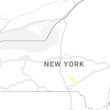
Hail Map for Saturday, April 15, 2023

Number of Impacted Households on 4/15/2023
0
Impacted by 1" or Larger Hail
0
Impacted by 1.75" or Larger Hail
0
Impacted by 2.5" or Larger Hail
Square Miles of Populated Area Impacted on 4/15/2023
0
Impacted by 1" or Larger Hail
0
Impacted by 1.75" or Larger Hail
0
Impacted by 2.5" or Larger Hail


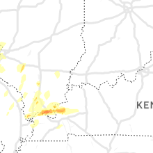
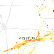


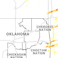


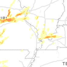
Cities Most Affected by Hail Storms of 4/15/2023
| Hail Size | Demographics of Zip Codes Affected | ||||||
|---|---|---|---|---|---|---|---|
| City | Count | Average | Largest | Pop Density | House Value | Income | Age |
| Pacific, MO | 5 | 2.05 | 3.00 | 209 | $117k | $48.3k | 39.6 |
| Bolivar, MO | 4 | 2.31 | 2.75 | 88 | $86k | $29.9k | 34.5 |
| Lamar, MO | 3 | 2.42 | 3.00 | 31 | $64k | $30.9k | 40.8 |
| Republic, MO | 3 | 2.08 | 2.50 | 356 | $84k | $36.7k | 33.6 |
| Ringgold, LA | 3 | 2.08 | 2.75 | 22 | $48k | $22.1k | 44.4 |
| Village Mills, TX | 3 | 2.08 | 2.50 | 0 | $103k | $50.0k | 55.0 |
| Magnolia, AR | 2 | 2.25 | 2.75 | 52 | $64k | $27.7k | 35.1 |
| Urbana, MO | 2 | 2.25 | 2.75 | 24 | $56k | $30.6k | 45.8 |
| Lockwood, MO | 1 | 4.00 | 4.00 | 11 | $50k | $28.1k | 42.2 |
| Fort Smith, AR | 2 | 1.88 | 2.00 | 2084 | $53k | $25.9k | 32.9 |
| Eureka, MO | 2 | 1.75 | 1.75 | 367 | $157k | $73.2k | 39.4 |
| Osage Beach, MO | 2 | 1.75 | 1.75 | 427 | $147k | $42.4k | 49.3 |
| Arcola, MO | 1 | 2.75 | 2.75 | 7 | $37k | $25.8k | 53.8 |
| Alma, AR | 1 | 2.50 | 2.50 | 144 | $81k | $33.9k | 36.7 |
| Dennard, AR | 1 | 2.50 | 2.50 | 13 | $45k | $23.2k | 45.2 |
| Mulberry, AR | 1 | 2.50 | 2.50 | 28 | $54k | $31.2k | 42.7 |
| Spiro, OK | 1 | 2.50 | 2.50 | 65 | $49k | $27.6k | 41.4 |
| Warren, TX | 1 | 2.50 | 2.50 | 12 | $45k | $32.9k | 44.0 |
| Converse, LA | 1 | 2.00 | 2.00 | 16 | $47k | $30.7k | 41.0 |
| Arkadelphia, AR | 1 | 2.00 | 2.00 | 37 | $76k | $29.8k | 33.0 |
| Reeds Spring, MO | 1 | 2.00 | 2.00 | 97 | $107k | $29.5k | 47.7 |
| Pittsburg, MO | 1 | 2.00 | 2.00 | 70 | $69k | $23.9k | 58.0 |
| Doyline, LA | 1 | 2.00 | 2.00 | 64 | $68k | $33.9k | 45.1 |
| Dyer, AR | 1 | 2.00 | 2.00 | 0 | $49k | $17.4k | 38.9 |
| Timpson, TX | 1 | 2.00 | 2.00 | 20 | $58k | $28.0k | 39.2 |
| Garfield, AR | 1 | 2.00 | 2.00 | 57 | $95k | $37.6k | 44.9 |
| Kountze, TX | 1 | 2.00 | 2.00 | 23 | $62k | $33.7k | 40.3 |
| Jerico Springs, MO | 1 | 2.00 | 2.00 | 10 | $42k | $32.9k | 48.5 |
| Bland, MO | 1 | 2.00 | 2.00 | 14 | $48k | $32.0k | 45.9 |
| Flemington, MO | 1 | 2.00 | 2.00 | 22 | $62k | $28.5k | 52.0 |
| Union, MO | 1 | 2.00 | 2.00 | 235 | $96k | $41.1k | 35.8 |
| Ozark, AR | 1 | 1.75 | 1.75 | 28 | $59k | $31.6k | 39.0 |
| Sour Lake, TX | 1 | 1.75 | 1.75 | 36 | $84k | $40.3k | 40.3 |
| Greenwood, AR | 1 | 1.75 | 1.75 | 150 | $79k | $37.5k | 36.8 |
| Labadie, MO | 1 | 1.75 | 1.75 | 89 | $152k | $62.1k | 42.4 |
| Shirley, AR | 1 | 1.75 | 1.75 | 29 | $57k | $25.3k | 45.8 |
| Dover, AR | 1 | 1.75 | 1.75 | 28 | $65k | $31.9k | 41.0 |
| Asbury, MO | 1 | 1.75 | 1.75 | 10 | $45k | $45.0k | 45.2 |
| Licking, MO | 1 | 1.75 | 1.75 | 21 | $60k | $23.7k | 38.2 |
| Villa Ridge, MO | 1 | 1.75 | 1.75 | 172 | $121k | $44.7k | 39.5 |
| Brixey, MO | 1 | 1.75 | 1.75 | 5 | $163k | $25.0k | 51.2 |
| Hermann, MO | 1 | 1.75 | 1.75 | 24 | $77k | $37.9k | 46.7 |
| Huntington, AR | 1 | 1.75 | 1.75 | 43 | $55k | $35.3k | 42.4 |
| Grover, MO | 1 | 1.75 | 1.75 | 1905 | $205k | $78.8k | 38.3 |
| Ballwin, MO | 1 | 1.75 | 1.75 | 2599 | $148k | $66.6k | 39.3 |
| San Augustine, TX | 1 | 1.75 | 1.75 | 17 | $53k | $26.6k | 45.2 |
| Shiner, TX | 1 | 1.75 | 1.75 | 23 | $56k | $29.4k | 46.2 |
| Wasola, MO | 1 | 1.75 | 1.75 | 10 | $58k | $19.9k | 46.9 |
| Clinton, AR | 1 | 1.75 | 1.75 | 22 | $61k | $24.7k | 44.4 |
| Owensville, MO | 1 | 1.75 | 1.75 | 32 | $74k | $34.4k | 43.0 |
| Springfield, MO | 1 | 1.75 | 1.75 | 684 | $67k | $28.2k | 32.2 |
Hail and Wind Damage Spotted on 4/15/2023
Filter by Report Type:Hail ReportsWind Reports
States Impacted
Missouri, Maryland, Louisiana, Mississippi, Kansas, New Jersey, Illinois, Alabama, Arkansas, Oklahoma, Kentucky, Florida, Texas, Georgia, TennesseeMissouri
| Local Time | Report Details |
|---|---|
| 7:24 AM CDT | Quarter sized hail reported near Camdenton, MO, 62.7 miles NNE of Springfield, MO, report from facebook with photo. |
| 7:24 AM CDT | Quarter sized hail reported near Camdenton, MO, 65.1 miles SSW of Columbia, MO, corrects previous hail report from camdenton. report from facebook with photo. |
| 1:04 PM CDT | Ping Pong Ball sized hail reported near Asbury, MO, 52.7 miles ESE of Chanute, KS |
| 1:15 PM CDT | Golf Ball sized hail reported near Asbury, MO, 54.7 miles ESE of Chanute, KS |
| 1:31 PM CDT | Golf Ball sized hail reported near Lamar, MO, 59.2 miles WNW of Springfield, MO, report from mping... golf ball... 1.75 in. |
| 1:39 PM CDT | Quarter sized hail reported near Lamar, MO, 58 miles WNW of Springfield, MO |
| 1:39 PM CDT | Half Dollar sized hail reported near Lamar, MO, 57.2 miles WNW of Springfield, MO |
| 1:58 PM CDT | Tennis Ball sized hail reported near Lamar, MO, 48.3 miles WNW of Springfield, MO, twitter with picture. |
| 2:01 PM CDT | Ping Pong Ball sized hail reported near Golden City, MO, 47 miles WNW of Springfield, MO |
| 2:05 PM CDT | Tea Cup sized hail reported near Lamar, MO, 51.5 miles WNW of Springfield, MO, twitter with pictures. |
| 2:07 PM CDT | Half Dollar sized hail reported near Golden City, MO, 45.2 miles WNW of Springfield, MO, polk county em. |
| 2:07 PM CDT | Half Dollar sized hail reported near Humansville, MO, 41.6 miles NNW of Springfield, MO, corrects previous hail report from 2 s golden city to 2 s humansville. polk county em. |
| 2:08 PM CDT | Half Dollar sized hail reported near Lamar, MO, 57.2 miles WNW of Springfield, MO, facebook with picture. |
| 2:08 PM CDT | Hen Egg sized hail reported near Flemington, MO, 43 miles NNW of Springfield, MO, picture via social media of approximately 2 inch diameter hail in flemington. time estimated from radar. |
| 2:09 PM CDT | Quarter sized hail reported near Stockton, MO, 43.6 miles NW of Springfield, MO, facebook with picture. |
| 2:20 PM CDT | Grapefruit sized hail reported near Lockwood, MO, 40.9 miles WNW of Springfield, MO, twitter with photos. some 3 in some 4 in. |
| 2:20 PM CDT | Hen Egg sized hail reported near Jerico Springs, MO, 48.6 miles NW of Springfield, MO, facebook with pictures. |
| 2:22 PM CDT | Hen Egg sized hail reported near Pittsburg, MO, 43.5 miles N of Springfield, MO, facebook with pictures. |
| 2:22 PM CDT | Baseball sized hail reported near Arcola, MO, 37 miles NW of Springfield, MO, facebook. |
| 2:22 PM CDT | Baseball sized hail reported near Bolivar, MO, 36.8 miles NNW of Springfield, MO |
| 2:34 PM CDT | Quarter sized hail reported near Urbana, MO, 44.3 miles N of Springfield, MO, near bisbee acres... via chat. |
| 2:39 PM CDT | Baseball sized hail reported near Urbana, MO, 45.4 miles N of Springfield, MO |
| 2:45 PM CDT | Quarter sized hail reported near Aldrich, MO, 29.9 miles NW of Springfield, MO |
| 2:45 PM CDT | Baseball sized hail reported near Bolivar, MO, 28.4 miles NNW of Springfield, MO |
| 2:45 PM CDT | Hen Egg sized hail reported near Bolivar, MO, 30.6 miles NNW of Springfield, MO, damage to plastic deck storage... siding... window screens. |
| 2:50 PM CDT | Ping Pong Ball sized hail reported near Bolivar, MO, 29.4 miles N of Springfield, MO, report from mping... ping pong ball... 1.50 in. |
| 2:53 PM CDT | Golf Ball sized hail reported near Bolivar, MO, 32.2 miles N of Springfield, MO, twitter with pictures. |
| 2:55 PM CDT | Quarter sized hail reported near Monett, MO, 40.9 miles WSW of Springfield, MO, quarter size hail... time approximate. |
| 2:56 PM CDT | Ping Pong Ball sized hail reported near Tunas, MO, 47.5 miles NNE of Springfield, MO |
| 3:00 PM CDT | Golf Ball sized hail reported near Urbana, MO, 44.8 miles N of Springfield, MO, facebook with picture. |
| 3:09 PM CDT | Half Dollar sized hail reported near Exeter, MO, 52.5 miles SW of Springfield, MO, report via social media of half dollar size hail near wheaton. time estimated from radar. |
| 3:11 PM CDT | Quarter sized hail reported near Seligman, MO, 64.8 miles SW of Springfield, MO, report from mping... quarter... 1.00 in. |
| 3:22 PM CDT | Quarter sized hail reported near Osage Beach, MO, 60.4 miles SSW of Columbia, MO, report from mping... quarter... 1.00 in. |
| 3:25 PM CDT | Golf Ball sized hail reported near Osage Beach, MO, 60.9 miles SSW of Columbia, MO |
| 3:26 PM CDT | Golf Ball sized hail reported near Osage Beach, MO, 59.1 miles SSW of Columbia, MO |
| 3:36 PM CDT | Ping Pong Ball sized hail reported near Montreal, MO, 63.8 miles NE of Springfield, MO, facebook with picture. |
| 3:36 PM CDT | Quarter sized hail reported near Half Way, MO, 30.5 miles N of Springfield, MO, twitter. |
| 3:39 PM CDT | Half Dollar sized hail reported near Eldridge, MO, 52.4 miles NNE of Springfield, MO, twitter with picture. |
| 3:40 PM CDT | Quarter sized hail reported near Aurora, MO, 28.8 miles SW of Springfield, MO, corrects previous hail report from aurora. quarter hail in aurora. time estimated from radar. |
| 3:42 PM CDT | Hen Egg sized hail reported near Republic, MO, 13 miles WSW of Springfield, MO, off duty nws employee. |
| 3:43 PM CDT | Tennis Ball sized hail reported near Republic, MO, 11.2 miles WSW of Springfield, MO |
| 3:48 PM CDT | Golf Ball sized hail reported near Republic, MO, 11.3 miles WSW of Springfield, MO, report from mping... golf ball... 1.75 in. |
| 3:49 PM CDT | Quarter sized hail reported near Billings, MO, 15.6 miles SW of Springfield, MO, report from mping... quarter... 1.00 in. |
| 3:51 PM CDT | Quarter sized hail reported near Springfield, MO, 4.5 miles WSW of Springfield, MO, report from mping... quarter... 1.00 in. |
| 3:53 PM CDT | Quarter sized hail reported near Springfield, MO, 3.3 miles W of Springfield, MO, report from mping... quarter... 1.00 in. |
| 3:54 PM CDT | Quarter sized hail reported near Springfield, MO, 4.2 miles SW of Springfield, MO, report from mping... quarter... 1.00 in. |
| 3:55 PM CDT | Ping Pong Ball sized hail reported near Springfield, MO, 1.7 miles WSW of Springfield, MO |
| 3:57 PM CDT | Quarter sized hail reported near Springfield, MO, 3.3 miles W of Springfield, MO, report from mping... quarter... 1.00 in. |
| 4:00 PM CDT | Quarter sized hail reported near Springfield, MO, 2.2 miles SSW of Springfield, MO, report from mping... quarter... 1.00 in. |
| 4:00 PM CDT | Power outages due to win in miller county MO, 47.9 miles NW of Salem, MO |
| 4:00 PM CDT | Quarter sized hail reported near Owensville, MO, 49.3 miles N of Salem, MO |
| 4:02 PM CDT | Quarter sized hail reported near Springfield, MO, 4.9 miles W of Springfield, MO, report from mping... quarter... 1.00 in. |
| 4:02 PM CDT | Quarter sized hail reported near Springfield, MO, 0.6 miles E of Springfield, MO, report from mping... quarter... 1.00 in. |
| 4:02 PM CDT | Quarter sized hail reported near Springfield, MO, 2.1 miles SSW of Springfield, MO, report from mping... quarter... 1.00 in. |
| 4:04 PM CDT | Golf Ball sized hail reported near Springfield, MO, 2.4 miles ESE of Springfield, MO, report from mping... golf ball... 1.75 in. |
| 4:04 PM CDT | Quarter sized hail reported near Thornfield, MO, 55.5 miles SE of Springfield, MO, delayed report. boater on lake had quarter size hail. time estimated from radar. |
| 4:05 PM CDT | Hen Egg sized hail reported near Reeds Spring, MO, 31.7 miles S of Springfield, MO, large hail... estimated up to 2 inches in diameter along 160 between reeds spring and walnut shade. time estimated from radar. |
| 4:10 PM CDT | Ping Pong Ball sized hail reported near Iberia, MO, 54.6 miles S of Columbia, MO, twitter with pictures. |
| 4:14 PM CDT | Golf Ball sized hail reported near Owensville, MO, 54.3 miles SE of Columbia, MO |
| 4:15 PM CDT | Quarter sized hail reported near Blue Eye, MO, 45.1 miles S of Springfield, MO, report from mping... quarter... 1.00 in. |
| 4:15 PM CDT | Quarter sized hail reported near Branson, MO, 33.8 miles S of Springfield, MO, email with pictures. |
| 4:16 PM CDT | Golf Ball sized hail reported near Hermann, MO, 50.6 miles ESE of Columbia, MO |
| 4:19 PM CDT | Quarter sized hail reported near Squires, MO, 44.6 miles ESE of Springfield, MO |
| 4:23 PM CDT | Report from mping... 1-inch tree limbs broken... shingles blown of in taney county MO, 39.3 miles S of Springfield, MO |
| 4:29 PM CDT | Quarter sized hail reported near Crocker, MO, 45.5 miles WNW of Salem, MO, report from mping... quarter... 1.00 in. |
| 4:30 PM CDT | Quarter sized hail reported near New Haven, MO, 60.1 miles W of Saint Louis, MO |
| 4:30 PM CDT | Quarter sized hail reported near Marshfield, MO, 25.1 miles ENE of Springfield, MO, public report sent in of measured 1 inch hail. time estimated from radar. |
| 4:32 PM CDT | Half Dollar sized hail reported near Ava, MO, 47.5 miles ESE of Springfield, MO, email with picture. |
| 4:35 PM CDT | Golf Ball sized hail reported near Wasola, MO, 54.4 miles SE of Springfield, MO |
| 4:37 PM CDT | Quarter sized hail reported near Monett, MO, 38.6 miles WSW of Springfield, MO, email with pictures. |
| 4:41 PM CDT | Ping Pong Ball sized hail reported near Hermann, MO, 47.3 miles ESE of Columbia, MO |
| 4:45 PM CDT | Storm damage reported in maries county MO, 36.3 miles NNW of Salem, MO |
| 4:48 PM CDT | Quarter sized hail reported near Brixey, MO, 58.6 miles ESE of Springfield, MO |
| 4:48 PM CDT | Golf Ball sized hail reported near Brixey, MO, 58.6 miles ESE of Springfield, MO, corrects previous hail report from brixey. |
| 4:52 PM CDT | Report from mping... 1-inch tree limbs broken... shingles blown of in phelps county MO, 27.1 miles NNW of Salem, MO |
| 4:52 PM CDT | Report from mping... 3-inch tree limbs broken... power poles broke in maries county MO, 33.6 miles NNW of Salem, MO |
| 4:55 PM CDT | Hen Egg sized hail reported near Bland, MO, 46 miles N of Salem, MO, very high winds also reported by law enforcement. |
| 4:55 PM CDT | Golf Ball sized hail reported near Licking, MO, 30.2 miles WSW of Salem, MO, golf ball sized in success... missouri. |
| 5:01 PM CDT | Mobile home damage... mobile home off foundation... barn roof ripped off... trees laying to west... debris in roadway in maries county MO, 38 miles NNW of Salem, MO |
| 5:03 PM CDT | Quarter sized hail reported near Drury, MO, 56.8 miles ESE of Springfield, MO, quarter hail at highway 15 and 95. |
| 5:03 PM CDT | Corrects previous tstm wnd gst report from odin. spotter reported 60 mph winds west of hartville at odin and highway 3 in wright county MO, 37.3 miles E of Springfield, MO |
| 5:06 PM CDT | Photo on twitter shows large tree down across highway 19. time estimated from rada in gasconade county MO, 42.4 miles N of Salem, MO |
| 5:06 PM CDT | Quarter sized hail reported near Cuba, MO, 30.7 miles NNE of Salem, MO, report from mping: quarter (1.00 in.). |
| 5:06 PM CDT | Quarter sized hail reported near Union, MO, 46.3 miles WSW of Saint Louis, MO, report from mping: quarter (1.00 in.). |
| 5:07 PM CDT | Quarter sized hail reported near Union, MO, 45.8 miles WSW of Saint Louis, MO, several reports of 1 inch hail between 507-510 pm. |
| 5:09 PM CDT | Quarter sized hail reported near Union, MO, 46.1 miles WSW of Saint Louis, MO, report from mping: quarter (1.00 in.). |
| 5:10 PM CDT | Quarter sized hail reported near Union, MO, 46 miles WSW of Saint Louis, MO |
| 5:12 PM CDT | Quarter sized hail reported near Union, MO, 43.9 miles WSW of Saint Louis, MO, report from mping: quarter (1.00 in.). |
| 5:15 PM CDT | Quarter sized hail reported near Mountain Grove, MO, 57 miles ESE of Springfield, MO |
| 5:16 PM CDT | Hen Egg sized hail reported near Union, MO, 45.1 miles WSW of Saint Louis, MO |
| 5:18 PM CDT | Quarter sized hail reported near Bourbon, MO, 39.5 miles NNE of Salem, MO, covering the ground. |
| 5:18 PM CDT | Two barns were reported to have been damage in ozark county MO, 67.7 miles ESE of Springfield, MO |
| 5:23 PM CDT | Half Dollar sized hail reported near Villa Ridge, MO, 38.6 miles WSW of Saint Louis, MO |
| 5:24 PM CDT | Quarter sized hail reported near Sullivan, MO, 44.9 miles NNE of Salem, MO |
| 5:25 PM CDT | Quarter sized hail reported near Bourbon, MO, 42.3 miles NNE of Salem, MO, quarter size hail south of sullivan. |
| 5:26 PM CDT | Report from mping... trees uprooted or snapped;...roof blown of in maries county MO, 37.5 miles NNW of Salem, MO |
| 5:30 PM CDT | Image on twitter shows large tree snapped at the base. time estimated from rada in franklin county MO, 45.2 miles NNE of Salem, MO |
| 5:30 PM CDT | Portion of roof blown off building in downtown sullivan. time estimated by rada in franklin county MO, 44.5 miles NNE of Salem, MO |
| 5:30 PM CDT | Social media report shows damage to a structure in sulliva in franklin county MO, 44.9 miles NNE of Salem, MO |
| 5:32 PM CDT | Half Dollar sized hail reported near Labadie, MO, 33.7 miles WSW of Saint Louis, MO, report from mping: half dollar (1.25 in.). |
| 5:33 PM CDT | Kuno asos measured 61mph wind gust with thunderstorm in howell county MO, 55.9 miles SSW of Salem, MO |
| 5:36 PM CDT | A tree and power pole were downed in lickin in texas county MO, 20.2 miles WSW of Salem, MO |
| 5:37 PM CDT | Quarter sized hail reported near Sullivan, MO, 45.2 miles NNE of Salem, MO, gusting winds as well. |
| 5:37 PM CDT | Golf Ball sized hail reported near Villa Ridge, MO, 39.7 miles WSW of Saint Louis, MO, via twitter with pictures. |
| 5:39 PM CDT | Quarter sized hail reported near Salem, MO, 3.3 miles NNE of Salem, MO, report from mping of quarter size. time estimated from radar. |
| 5:41 PM CDT | Ping Pong Ball sized hail reported near Villa Ridge, MO, 37.9 miles WSW of Saint Louis, MO, report from mping: ping pong ball (1.50 in.). |
| 5:42 PM CDT | Ping Pong Ball sized hail reported near Villa Ridge, MO, 37.9 miles WSW of Saint Louis, MO, report from mping: ping pong ball (1.50 in.). |
| 5:43 PM CDT | Ping Pong Ball sized hail reported near Labadie, MO, 33.9 miles WSW of Saint Louis, MO, report from mping: ping pong ball (1.50 in.). |
| 5:45 PM CDT | Half Dollar sized hail reported near Pacific, MO, 32.5 miles WSW of Saint Louis, MO |
| 5:45 PM CDT | Golf Ball sized hail reported near Labadie, MO, 33.7 miles WSW of Saint Louis, MO, report from mping: golf ball (1.75 in.). |
| 5:46 PM CDT | Report from mping: 1-inch tree limbs broken; shingles blown of in franklin county MO, 33.7 miles WSW of Saint Louis, MO |
| 5:48 PM CDT | Half Dollar sized hail reported near Pacific, MO, 31 miles WSW of Saint Louis, MO |
| 5:48 PM CDT | Golf Ball sized hail reported near Pacific, MO, 31.3 miles WSW of Saint Louis, MO, max size golf ball. |
| 5:49 PM CDT | Hen Egg sized hail reported near Pacific, MO, 31.5 miles WSW of Saint Louis, MO |
| 5:49 PM CDT | Tea Cup sized hail reported near Pacific, MO, 30.8 miles WSW of Saint Louis, MO, photo on twitter shows measured hail of 3 inches in diameter. time estimated from radar. |
| 5:51 PM CDT | Ping Pong Ball sized hail reported near Pacific, MO, 29.5 miles WSW of Saint Louis, MO, report from mping: ping pong ball (1.50 in.). |
| 5:56 PM CDT | Quarter sized hail reported near Labadie, MO, 34.6 miles W of Saint Louis, MO |
| 6:00 PM CDT | Quarter sized hail reported near Glencoe, MO, 24.5 miles W of Saint Louis, MO, report from mping: quarter (1.00 in.). |
| 6:00 PM CDT | Golf Ball sized hail reported near Pacific, MO, 30.7 miles WSW of Saint Louis, MO, report from mping: golf ball (1.75 in.). |
| 6:01 PM CDT | Quarter sized hail reported near Glencoe, MO, 25.1 miles W of Saint Louis, MO |
| 6:02 PM CDT | Quarter sized hail reported near Ballwin, MO, 19.1 miles W of Saint Louis, MO |
| 6:03 PM CDT | Half Dollar sized hail reported near Eureka, MO, 24.2 miles WSW of Saint Louis, MO |
| 6:04 PM CDT | Golf Ball sized hail reported near Eureka, MO, 26.2 miles WSW of Saint Louis, MO, report from mping: golf ball (1.75 in.). |
| 6:05 PM CDT | Quarter sized hail reported near Eureka, MO, 25.4 miles WSW of Saint Louis, MO, report from mping: quarter (1.00 in.). |
| 6:05 PM CDT | Golf Ball sized hail reported near Pacific, MO, 27 miles WSW of Saint Louis, MO, report from mping: golf ball (1.75 in.). |
| 6:06 PM CDT | Half Dollar sized hail reported near Eureka, MO, 24.6 miles WSW of Saint Louis, MO, report from mping: half dollar (1.25 in.). |
| 6:07 PM CDT | Quarter sized hail reported near Chesterfield, MO, 18 miles W of Saint Louis, MO |
| 6:07 PM CDT | Golf Ball sized hail reported near Eureka, MO, 24.7 miles WSW of Saint Louis, MO, report on twitter of ping pong to golf ball size hail. |
| 6:08 PM CDT | Quarter sized hail reported near Chesterfield, MO, 16.8 miles W of Saint Louis, MO |
| 6:10 PM CDT | Quarter sized hail reported near Saint Louis, MO, 13.9 miles WNW of Saint Louis, MO |
| 6:11 PM CDT | Quarter sized hail reported near Eureka, MO, 24.7 miles WSW of Saint Louis, MO, report from mping: quarter (1.00 in.). |
| 6:16 PM CDT | Quarter sized hail reported near Chesterfield, MO, 19 miles W of Saint Louis, MO, former nws employee report. |
| 6:17 PM CDT | Quarter sized hail reported near Maryland Heights, MO, 16 miles WNW of Saint Louis, MO |
| 6:18 PM CDT | Quarter sized hail reported near Ballwin, MO, 19.3 miles W of Saint Louis, MO |
| 6:20 PM CDT | Photo on twitter shows a wall of windows collapsed at the ballwin pointe rec center. time estimated from rada in st. louis county MO, 19.3 miles W of Saint Louis, MO |
| 6:21 PM CDT | Golf Ball sized hail reported near Grover, MO, 23 miles W of Saint Louis, MO, report from mping: golf ball (1.75 in.). |
| 6:22 PM CDT | Numerous trees down in buder upper par in st. louis county MO, 16.9 miles WSW of Saint Louis, MO |
| 6:23 PM CDT | Several homes missing parts of their roofs... large tree limbs down. possible tornad in st. louis county MO, 17.6 miles WSW of Saint Louis, MO |
| 6:23 PM CDT | Large trees limbs down... shingles off roof... wind estimated 60-70 mp in jefferson county MO, 34 miles SW of Saint Louis, MO |
| 6:25 PM CDT | Fire chief reports multiple trees snapped... a church steeple with the glass blown out... a few trees into houses... health department had a window blown ou in jefferson county MO, 33.7 miles SW of Saint Louis, MO |
| 6:26 PM CDT | Large tree blocking roadwa in st. louis county MO, 16.8 miles W of Saint Louis, MO |
| 6:28 PM CDT | Quarter sized hail reported near Ballwin, MO, 18.3 miles WSW of Saint Louis, MO, report from mping: quarter (1.00 in.). |
| 6:30 PM CDT | Shingles off roofs... branches dow in jefferson county MO, 33.7 miles SW of Saint Louis, MO |
| 6:31 PM CDT | Ping Pong Ball sized hail reported near Ballwin, MO, 18.3 miles WSW of Saint Louis, MO, report from mping: ping pong ball (1.50 in.). |
| 6:34 PM CDT | Golf Ball sized hail reported near Ballwin, MO, 16.1 miles WSW of Saint Louis, MO |
| 6:34 PM CDT | Quarter sized hail reported near Festus, MO, 30.4 miles SSW of Saint Louis, MO, report from mping: quarter (1.00 in.). |
| 6:35 PM CDT | Tractor trailer overturned on southbound i-55 near mcnutt. time estimated from rada in jefferson county MO, 27.6 miles SSW of Saint Louis, MO |
| 6:37 PM CDT | Large tree branch blocking traffi in st. louis county MO, 11.9 miles W of Saint Louis, MO |
| 6:37 PM CDT | Estimated 60 mph gusts with pea size hai in st. louis county MO, 11.9 miles WSW of Saint Louis, MO |
| 6:37 PM CDT | Power lines down at hwy 8 and harmon rd in frankcla in st. francois county MO, 51.6 miles ENE of Salem, MO |
| 6:40 PM CDT | Trees down... power lines down... debris - main street of hillsbor in jefferson county MO, 33.7 miles SW of Saint Louis, MO |
| 6:40 PM CDT | Quarter sized hail reported near Chesterfield, MO, 16.8 miles W of Saint Louis, MO |
| 6:40 PM CDT | Report from mping: 3-inch tree limbs broken; power poles broke in jefferson county MO, 27.4 miles SSW of Saint Louis, MO |
| 6:41 PM CDT | Quarter sized hail reported near Hillsboro, MO, 33.7 miles SW of Saint Louis, MO |
| 6:42 PM CDT | Images on twitter show several large trees and tree limbs snapped. time estimated from rada in st. louis city county MO, 5.5 miles SW of Saint Louis, MO |
| 6:43 PM CDT | Kstl asos. also gusted to 59 mph at 639 p in st. louis county MO, 12.5 miles NW of Saint Louis, MO |
| 6:44 PM CDT | Quarter sized hail reported near Pevely, MO, 28 miles SSW of Saint Louis, MO, report from mping: quarter (1.00 in.). |
| 6:46 PM CDT | Report of overturned vehicles on i-5 in jefferson county MO, 25.7 miles SSW of Saint Louis, MO |
| 6:47 PM CDT | Report from mping: 3-inch tree limbs broken; power poles broke in st. louis city county MO, 4.4 miles WNW of Saint Louis, MO |
| 6:48 PM CDT | Trees dow in st. louis county MO, 15.2 miles W of Saint Louis, MO |
| 6:51 PM CDT | Quarter sized hail reported near Pevely, MO, 26.1 miles SSW of Saint Louis, MO, report from mping: quarter (1.00 in.). |
| 6:52 PM CDT | Quarter sized hail reported near Pevely, MO, 25.7 miles SSW of Saint Louis, MO |
| 6:53 PM CDT | Trees dow in st. louis county MO, 11.9 miles W of Saint Louis, MO |
| 6:54 PM CDT | Trees dow in st. louis county MO, 15.2 miles W of Saint Louis, MO |
| 6:55 PM CDT | I-44 and hampto in st. louis city county MO, 4.9 miles W of Saint Louis, MO |
| 6:55 PM CDT | Report from mping: 3-inch tree limbs broken; power poles broke in st. louis county MO, 12.1 miles N of Saint Louis, MO |
| 6:56 PM CDT | Quarter sized hail reported near Saint Louis, MO, 3.8 miles WSW of Saint Louis, MO, also 30-40 mph winds. |
| 6:57 PM CDT | Tree limbs dow in st. francois county MO, 56.7 miles ENE of Salem, MO |
| 7:00 PM CDT | Report from mping: trees uprooted or snapped; roof blown of in st. louis city county MO, 4.6 miles SW of Saint Louis, MO |
| 7:00 PM CDT | Quarter sized hail reported near Saint Louis, MO, 4.6 miles SW of Saint Louis, MO, report from mping: quarter (1.00 in.). |
| 7:01 PM CDT | Large tree dow in st. louis county MO, 9.8 miles W of Saint Louis, MO |
| 7:51 PM CDT | Tree down onto a power line causing power outage in butler county MO, 59 miles SW of Cape Girardeau, MO |
| 9:12 PM CDT | Spotter reported 60 mph winds west of hartville at odin and highway 3 in wright county MO, 37.3 miles E of Springfield, MO |
Maryland
| Local Time | Report Details |
|---|---|
| 11:52 AM EDT | Quarter sized hail reported near Union Bridge, MD, 34.2 miles NW of Baltimore, MD |
| 1:36 PM EDT | Quarter sized hail reported near Reisterstown, MD, 15 miles NW of Baltimore, MD |
| 1:36 PM EDT | Half Dollar sized hail reported near Reisterstown, MD, 15.9 miles NW of Baltimore, MD, mping report of half dollar sized hail in reisterstown. |
| 4:05 PM EDT | A tree fell on powerlines near governor bridge rd and blackberry l in anne arundel county MD, 23.5 miles S of Baltimore, MD |
Louisiana
| Local Time | Report Details |
|---|---|
| 12:00 PM CDT | Tree blown over just east of hwy 445 and hwy 16 intersectio in tangipahoa county LA, 56.4 miles NNW of New Orleans, LA |
| 1:07 PM CDT | Mesonet station xptn pontchartrain causeway measured wind gust of 64 mph or 56 knot in gmz530 county LA, 17.2 miles N of New Orleans, LA |
| 1:08 PM CDT | Powerlines down due to trees falling on them near cloverland rd and fish hatchery r in st. tammany county LA, 27 miles NNE of New Orleans, LA |
| 1:14 PM CDT | Corrects previous tstm wnd dmg report from 4 nw slidell. trees down over interstate partially blocking lane in st. tammany county LA, 28.7 miles NNE of New Orleans, LA |
| 1:18 PM CDT | Trees down along bayou liberty road blocking both lane in st. tammany county LA, 26.7 miles NE of New Orleans, LA |
| 1:24 PM CDT | Weather station measured wind gust of 67 mph or 58 knot in st. tammany county LA, 25.1 miles NE of New Orleans, LA |
| 1:30 PM CDT | Corrects previous non-tstm wnd gst report from 7 e east new orleans. mesonet station 1825w nofd engine 31 - venetian isle in orleans county LA, 17.9 miles ENE of New Orleans, LA |
| 1:40 PM CDT | Trees down over interstate partially blocking lane in st. tammany county LA, 28.7 miles NNE of New Orleans, LA |
| 1:53 PM CDT | Asos station knew new orleans lakefront airport measured gust o 59 mph or 51 knot in orleans county LA, 6.6 miles NNE of New Orleans, LA |
| 5:00 PM CDT | Ping Pong Ball sized hail reported near Haughton, LA, 10.6 miles ENE of Shreveport, LA |
| 5:00 PM CDT | Ping Pong Ball sized hail reported near Barksdale AFB, LA, 4.6 miles ESE of Shreveport, LA |
| 5:09 PM CDT | Half Dollar sized hail reported near Bossier City, LA, 4.8 miles ENE of Shreveport, LA, lots of quarter size hail. a couple just smaller than ping pong ball size (~1.3â€). all stones larger than quarters are pancake shaped. |
| 5:22 PM CDT | Half Dollar sized hail reported near Bossier City, LA, 2.8 miles E of Shreveport, LA |
| 5:39 PM CDT | Ping Pong Ball sized hail reported near Haughton, LA, 13.9 miles E of Shreveport, LA |
| 6:10 PM CDT | Hen Egg sized hail reported near Doyline, LA, 21.3 miles ESE of Shreveport, LA, report via social media. |
| 6:20 PM CDT | Golf Ball sized hail reported near Ringgold, LA, 30.1 miles ESE of Shreveport, LA |
| 6:20 PM CDT | Ping Pong Ball sized hail reported near Ringgold, LA, 23.8 miles SE of Shreveport, LA, report via social media. |
| 6:40 PM CDT | Baseball sized hail reported near Ringgold, LA, 28 miles ESE of Shreveport, LA, baseball sized. |
| 6:45 PM CDT | Hen Egg sized hail reported near Converse, LA, 50.7 miles S of Shreveport, LA |
| 6:51 PM CDT | Ping Pong Ball sized hail reported near Heflin, LA, 28.1 miles E of Shreveport, LA, report via social media with picture. |
| 7:00 PM CDT | Half Dollar sized hail reported near Noble, LA, 57.5 miles S of Shreveport, LA, report from mping: half dollar (1.25 in.). |
| 7:01 PM CDT | Golf Ball sized hail reported near Ringgold, LA, 28.8 miles ESE of Shreveport, LA |
| 7:33 PM CDT | Reports of powerlines and a few trees down between black lake and campti... l in natchitoches county LA, 56.1 miles SE of Shreveport, LA |
| 7:57 PM CDT | Reports of trees down on highway 84 east of clarenc in natchitoches county LA, 64.5 miles SE of Shreveport, LA |
| 8:05 PM CDT | Quarter sized hail reported near Haughton, LA, 14.2 miles ESE of Shreveport, LA, gas station at the corner of 612 and 157 reported nickel to quarter size hail. |
| 8:09 PM CDT | Reports of a few trees and powerlines down in tow in sabine county LA, 66.9 miles SSE of Shreveport, LA |
| 8:10 PM CDT | Quarter sized hail reported near Sibley, LA, 26.2 miles E of Shreveport, LA, store in sibley reported dime to quarter size hail for several minutes. |
| 8:12 PM CDT | Quarter sized hail reported near Homer, LA, 42.4 miles ENE of Shreveport, LA, report from local gas station. |
| 9:15 PM CDT | Tree reported down at the corner of five oaks road and highway 55 in union county LA, 35.4 miles WNW of Bastrop, LA |
| 9:54 PM CDT | Quarter sized hail reported near Alexandria, LA, 80.6 miles NNW of Lafayette, LA, quarter size hail reported by the rapides parish emergency management direcotr. |
| 2:14 AM CDT | Quarter sized hail reported near New Orleans, LA, 4.7 miles ESE of New Orleans, LA, hail around the size of quarters reported in algiers. report via social media and nwschat. |
| 2:21 AM CDT | Dulac measured a sustained wind of 46 mph and a gust of 65 mp in terrebonne county LA, 57.2 miles SW of New Orleans, LA |
| 2:55 AM CDT | Awos station kgao gallian in lafourche county LA, 36.6 miles SSW of New Orleans, LA |
| 3:12 AM CDT | Buoy station gisl1 grand isle... l in jefferson county LA, 48.3 miles S of New Orleans, LA |
| 3:48 AM CDT | Pilot station east (pstl1) recorded a sustained wind of 40kt with a peak gust of 59k in gmz552 county LA, 81.2 miles SSE of New Orleans, LA |
Mississippi
| Local Time | Report Details |
|---|---|
| 12:03 PM CDT | Trees down... with one on a house with an entrapment. multiple chicken houses damaged and powerlines down. time estimated by rada in walthall county MS, 77.1 miles S of Jackson, MS |
| 12:13 PM CDT | Quarter sized hail reported near Foxworth, MS, 80.7 miles SSE of Jackson, MS, pretty good sized hail reported. |
| 12:13 PM CDT | Tree downe in marion county MS, 76.6 miles S of Jackson, MS |
| 12:55 PM CDT | Tree down across ford loo in lamar county MS, 82.6 miles SSE of Jackson, MS |
| 1:10 PM CDT | Quarter sized hail reported near Stringer, MS, 63.4 miles ESE of Jackson, MS, lots of hail... few stones up to quarter size. |
| 1:33 PM CDT | Broadcast media relayed a viewer report of a large tree that fell at the entrance to flint creek water park. time estimated from rada in stone county MS, 64.7 miles WNW of Mobile, AL |
| 1:44 PM CDT | Tin roof ripped off of bay marin in hancock county MS, 48.8 miles ENE of New Orleans, LA |
| 1:45 PM CDT | Multiple trees down on the road along highway 57 in the community of benndal in george county MS, 46.8 miles WNW of Mobile, AL |
| 2:12 PM CDT | 1-inch tree limbs broken and shingles blown of in harrison county MS, 58.4 miles WSW of Mobile, AL |
| 2:17 PM CDT | Large tree limb on shed shared via social media. time estimated by rada in harrison county MS, 55 miles WSW of Mobile, AL |
| 2:28 PM CDT | Large tree limbs down on powerline in vancleave... causing one to snap. time estimated by rada in jackson county MS, 38.7 miles WSW of Mobile, AL |
| 9:00 PM CDT | Tree fallen on hous in desoto county MS, 11.2 miles SSE of Memphis, TN |
Kansas
| Local Time | Report Details |
|---|---|
| 12:26 PM CDT | Quarter sized hail reported near Douglass, KS, 20.8 miles ESE of Wichita, KS, spotter report relayed via butler county emergency management. |
| 12:50 PM CDT | Quarter sized hail reported near Pittsburg, KS, 46.4 miles ESE of Chanute, KS, 1 inch hail relayed via chat by amateur radio. |
| 1:05 PM CDT | Ping Pong Ball sized hail reported near Pittsburg, KS, 46.9 miles ESE of Chanute, KS, reported via twitter with picture. |
New Jersey
| Local Time | Report Details |
|---|---|
| 2:05 PM EDT | Quarter sized hail reported near Piscataway, NJ, 28 miles WSW of Brooklyn, NY, quarter-sized hail reported on i-287. |
| 2:30 PM EDT | Quarter sized hail reported near Budd Lake, NJ, 40.9 miles WNW of Brooklyn, NY |
| 4:05 PM EDT | Quarter sized hail reported near Lumberton, NJ, 69.3 miles SW of Brooklyn, NY, mount laurel township. |
| 4:23 PM EDT | Corrects previous tstm wnd dmg report from 3 ene moorestown. multiple large tree limbs down across portions of hartford road just north of marne highwa in burlington county NJ, 68.4 miles SW of Brooklyn, NY |
Illinois
| Local Time | Report Details |
|---|---|
| 2:07 PM CDT | Quarter sized hail reported near Olive Branch, IL, 15.8 miles SE of Cape Girardeau, MO, quarter size hail reported at horseshoe lake. |
| 2:40 PM CDT | Quarter sized hail reported near Olmsted, IL, 27 miles ESE of Cape Girardeau, MO |
| 2:40 PM CDT | Several tree limbs down around the town of olmste in pulaski county IL, 27 miles ESE of Cape Girardeau, MO |
| 3:02 PM CDT | Quarter sized hail reported near Belknap, IL, 42.7 miles E of Cape Girardeau, MO, time estimated from radar. |
| 3:08 PM CDT | Several trees and large limbs down at airport and upper salem roa in massac county IL, 44.2 miles E of Cape Girardeau, MO |
| 3:22 PM CDT | Quarter sized hail reported near Golconda, IL, 54.3 miles E of Cape Girardeau, MO, hail up to 1 inch in size accumulated several inches deep in rural pope county. time estimated from radar. |
| 5:42 PM CDT | Quarter sized hail reported near Basco, IL, 23.5 miles ESE of Kahoka, MO |
| 5:47 PM CDT | Quarter sized hail reported near Basco, IL, 28.1 miles ESE of Kahoka, MO, a couple of quarter size hailstones reported. time estimated by radar. |
| 6:22 PM CDT | Half Dollar sized hail reported near Blandinsville, IL, 42.3 miles E of Kahoka, MO, delayed report. |
| 6:30 PM CDT | Large tree branches reported dow in morgan county IL, 73.7 miles ESE of Kahoka, MO |
| 6:43 PM CDT | Images from twitter show multiple large trees and tree branches snapped at a residence in madonnaville off of ahne road. portions of a tin roof of an outbuilding on the in monroe county IL, 24.8 miles S of Saint Louis, MO |
| 6:44 PM CDT | Images in a local news story shows a tree down along highway 156 near valmeyer. time estimated from rada in monroe county IL, 22.2 miles S of Saint Louis, MO |
| 6:45 PM CDT | Large tree down. relayed via social media. time estimated from rada in cass county IL, 63 miles SW of Peoria, IL |
| 6:45 PM CDT | Storm damage reported in madison county IL, 15.3 miles NNE of Saint Louis, MO |
| 6:48 PM CDT | Quarter sized hail reported near Valmeyer, IL, 23 miles SSW of Saint Louis, MO, report from mping: quarter (1.00 in.). |
| 7:00 PM CDT | Trees down along route 15 in monroe county IL, 21.2 miles S of Saint Louis, MO |
| 7:02 PM CDT | Picture from social media shows large tree blown down and multiple large limbs down in bellevill in st. clair county IL, 12.7 miles ESE of Saint Louis, MO |
| 7:10 PM CDT | Storm damage reported in st. clair county IL, 12.7 miles ESE of Saint Louis, MO |
| 7:12 PM CDT | Storm damage reported in st. clair county IL, 14.4 miles SE of Saint Louis, MO |
| 7:15 PM CDT | Home with roof damag in st. clair county IL, 14.8 miles ESE of Saint Louis, MO |
| 7:16 PM CDT | Report from mping: 3-inch tree limbs broken; power poles broke in st. clair county IL, 14.3 miles E of Saint Louis, MO |
| 7:20 PM CDT | Report from mping: 3-inch tree limbs broken; power poles broke in st. clair county IL, 32.7 miles SE of Saint Louis, MO |
| 7:25 PM CDT | Outbuilding destroyed. roof blown of in madison county IL, 23.9 miles ENE of Saint Louis, MO |
| 7:34 PM CDT | Large tree branch down onto a power line. time estimated from rada in washington county IL, 46.8 miles ESE of Saint Louis, MO |
| 7:37 PM CDT | Large tree branch down on power line in washington county IL, 46.8 miles ESE of Saint Louis, MO |
| 7:46 PM CDT | Storm damage reported in peoria county IL, 11.1 miles W of Peoria, IL |
| 7:49 PM CDT | Powerlines dow in fulton county IL, 44.8 miles W of Peoria, IL |
| 7:53 PM CDT | Estimated 60-70 mph wind in fulton county IL, 30.4 miles W of Peoria, IL |
| 7:58 PM CDT | Trees down and power out in southwest jefferson. winds estimated over 60 mp in jefferson county IL, 65.4 miles NNE of Cape Girardeau, MO |
| 8:00 PM CDT | Estimated wind gust in fulton county IL, 30.4 miles W of Peoria, IL |
| 8:00 PM CDT | Sporadic 2.5-4 tree limbs down north of fairview to approx 1 mile west of middlegrov in fulton county IL, 30.3 miles W of Peoria, IL |
| 8:01 PM CDT | Report from mping: trees uprooted or snapped; roof blown of in montgomery county IL, 47 miles NE of Saint Louis, MO |
| 8:05 PM CDT | Quarter sized hail reported near Peoria, IL, 6.9 miles NW of Peoria, IL |
| 8:09 PM CDT | Storm damage reported in peoria county IL, 17 miles NNW of Peoria, IL |
| 8:12 PM CDT | Quarter sized hail reported near Peoria, IL, 8.8 miles NNW of Peoria, IL, mping report. |
| 8:40 PM CDT | Quarter sized hail reported near , , 37.1 miles NE of Cape Girardeau, MO, quarter sized hail south of carterville. |
| 8:45 PM CDT | Trees reported down on power lines and over roadways. power outages also reporte in effingham county IL, 35.3 miles SW of Mattoon, IL |
| 8:45 PM CDT | Large tree branch down across route 51. relayed via social media photo. time estimated from rada in christian county IL, 38.2 miles W of Mattoon, IL |
| 8:48 PM CDT | Tree fell onto a power line near benton. relayed by wsil t in franklin county IL, 59.6 miles NE of Cape Girardeau, MO |
| 10:04 PM CDT | Asos station kcmi willard arp in champaign county IL, 38.2 miles N of Mattoon, IL |
Alabama
| Local Time | Report Details |
|---|---|
| 2:36 PM CDT | Broadcast media relayed a report on social media of a tree down... along with power outages in turnervill in mobile county AL, 20.7 miles NNW of Mobile, AL |
| 2:50 PM CDT | Emergency manager reports three trees down along cr 34 near the saint stephens community. time estimated from rada in washington county AL, 55.6 miles WSW of Camden, AL |
| 2:50 PM CDT | Multiple trees down near the communities of grand bay and irvingto in mobile county AL, 17.9 miles SSW of Mobile, AL |
| 3:00 PM CDT | Multiple trees down in the lake forest subdivision with one tree on a hom in baldwin county AL, 9.7 miles ESE of Mobile, AL |
| 3:00 PM CDT | Roof damage to at least one building. picture via social medi in baldwin county AL, 8.9 miles ESE of Mobile, AL |
| 3:05 PM CDT | Numerous reports of damaged trees near county road 2 in baldwin county AL, 12.9 miles ESE of Mobile, AL |
| 3:15 PM CDT | The loxley chili mesonet station recorded a wind gust of 58 mp in baldwin county AL, 19.5 miles E of Mobile, AL |
| 3:23 PM CDT | Broadcast media relayed a report of a pine tree downed in orange beach. time estimated from rada in baldwin county AL, 39.3 miles SE of Mobile, AL |
| 3:25 PM CDT | Marine thunderstorm wind gust to 58 mph at the awos station kvoa (viosca knoll768)... which is an elevated platfor in gmz670 county AL, 101.6 miles S of Mobile, AL |
| 3:52 PM CDT | Broadcast media relayed a report of structural damage to a residence on ponderosa ln near flomaton. time estimated from rada in escambia county AL, 52.9 miles ENE of Mobile, AL |
| 5:18 PM CDT | Trees down on highway 18 in coffee county AL, 69.3 miles NNE of Miramar Beach, FL |
| 5:21 PM CDT | Trees down on county road 41 in coffee county AL, 69.2 miles NNE of Miramar Beach, FL |
| 5:28 PM CDT | Trees down on county road 23 in coffee county AL, 77.3 miles NNE of Miramar Beach, FL |
| 5:30 PM CDT | Trees down on county road 24 in coffee county AL, 78.1 miles NNE of Miramar Beach, FL |
Arkansas
| Local Time | Report Details |
|---|---|
| 2:37 PM CDT | Quarter sized hail reported near Fayetteville, AR, 48.2 miles NNE of Fort Smith, AR |
| 2:39 PM CDT | Quarter sized hail reported near Fayetteville, AR, 52.3 miles NNE of Fort Smith, AR |
| 2:41 PM CDT | Quarter sized hail reported near Fayetteville, AR, 50.6 miles NNE of Fort Smith, AR |
| 2:47 PM CDT | Tree limbs up to one inch in diameter broke in benton county AR, 69.5 miles N of Fort Smith, AR |
| 2:50 PM CDT | Quarter sized hail reported near Fort Smith, AR, 3.6 miles NNE of Fort Smith, AR |
| 2:54 PM CDT | Large trees down with damage to a horse she in benton county AR, 60.5 miles N of Fort Smith, AR |
| 2:55 PM CDT | Thunderstorm winds estimated to 60 mp in benton county AR, 66.8 miles N of Fort Smith, AR |
| 2:55 PM CDT | Quarter sized hail reported near Centerton, AR, 67.7 miles N of Fort Smith, AR |
| 2:55 PM CDT | Quarter sized hail reported near Van Buren, AR, 6 miles NE of Fort Smith, AR |
| 2:55 PM CDT | Quarter sized hail reported near Fort Smith, AR, 0.3 miles SSE of Fort Smith, AR |
| 2:55 PM CDT | Hen Egg sized hail reported near Fort Smith, AR, 0.3 miles SSE of Fort Smith, AR |
| 2:56 PM CDT | Quarter sized hail reported near Bentonville, AR, 66 miles N of Fort Smith, AR |
| 2:57 PM CDT | Ping Pong Ball sized hail reported near Fort Smith, AR, 3.6 miles NNE of Fort Smith, AR |
| 3:02 PM CDT | Half Dollar sized hail reported near Bentonville, AR, 69.3 miles N of Fort Smith, AR |
| 3:04 PM CDT | Quarter sized hail reported near Fort Smith, AR, 2.9 miles E of Fort Smith, AR, social media report with picture. |
| 3:06 PM CDT | Golf Ball sized hail reported near Fort Smith, AR, 2.1 miles ENE of Fort Smith, AR |
| 3:09 PM CDT | Half Dollar sized hail reported near Pea Ridge, AR, 69.5 miles SW of Springfield, MO |
| 3:10 PM CDT | Tennis Ball sized hail reported near Alma, AR, 13.1 miles ENE of Fort Smith, AR |
| 3:12 PM CDT | Quarter sized hail reported near Bella Vista, AR, 73.2 miles SW of Springfield, MO, relayed by broadcast media. |
| 3:21 PM CDT | Broken tree limbs and some shingles blown off roo in sebastian county AR, 4.2 miles SE of Fort Smith, AR |
| 3:26 PM CDT | Hen Egg sized hail reported near Garfield, AR, 65.6 miles SW of Springfield, MO |
| 3:29 PM CDT | Quarter sized hail reported near Rogers, AR, 68.8 miles NNE of Fort Smith, AR, social media report. |
| 3:29 PM CDT | Tennis Ball sized hail reported near Mulberry, AR, 22.4 miles ENE of Fort Smith, AR |
| 3:30 PM CDT | Golf Ball sized hail reported near Dover, AR, 72.5 miles NW of Little Rock, AR, storm spotter reported 1.75 inch hail 9 miles northwest of hector... ar. |
| 3:30 PM CDT | Hen Egg sized hail reported near Dyer, AR, 17.8 miles ENE of Fort Smith, AR, relayed by storm chaser. |
| 3:30 PM CDT | Quarter sized hail reported near Mulberry, AR, 22.4 miles ENE of Fort Smith, AR |
| 3:37 PM CDT | Golf Ball sized hail reported near Huntington, AR, 19.5 miles SSE of Fort Smith, AR |
| 3:38 PM CDT | Quarter sized hail reported near Elkins, AR, 49.3 miles NNE of Fort Smith, AR |
| 3:40 PM CDT | Golf Ball sized hail reported near Greenwood, AR, 18.7 miles SE of Fort Smith, AR, hail observed near 2257 mt. harmondy raod southeast of greenwood. relayed by amateur radio. |
| 3:44 PM CDT | Golf Ball sized hail reported near Ozark, AR, 31.5 miles ENE of Fort Smith, AR, report relayed by emergency manager. |
| 3:50 PM CDT | Quarter sized hail reported near Paris, AR, 32.3 miles ESE of Fort Smith, AR |
| 3:51 PM CDT | Report of tree limb damag in sebastian county AR, 26.5 miles SSE of Fort Smith, AR |
| 3:58 PM CDT | Quarter sized hail reported near Booneville, AR, 29.7 miles ESE of Fort Smith, AR |
| 4:16 PM CDT | Quarter sized hail reported near Mena, AR, 52.2 miles SSE of Fort Smith, AR, report via mping. |
| 4:29 PM CDT | Quarter sized hail reported near Clarksville, AR, 51.7 miles E of Fort Smith, AR, social media report... estimated pea to quarter size hail in woodland... ar. |
| 4:38 PM CDT | Quarter sized hail reported near Subiaco, AR, 50.8 miles E of Fort Smith, AR, report via mping. |
| 4:55 PM CDT | Golf Ball sized hail reported near Clinton, AR, 66.2 miles NNW of Little Rock, AR |
| 4:55 PM CDT | Tennis Ball sized hail reported near Dennard, AR, 67.7 miles NNW of Little Rock, AR |
| 5:01 PM CDT | Storm damage reported in pope county AR, 58.2 miles NW of Little Rock, AR |
| 5:05 PM CDT | Corrects previous tstm wnd dmg report from 3 ne russellville regional airport. large trees blown down... roots pulled from groun in pope county AR, 58.1 miles NW of Little Rock, AR |
| 5:06 PM CDT | Golf Ball sized hail reported near Magnolia, AR, 52.5 miles NNE of Shreveport, LA |
| 5:10 PM CDT | Half Dollar sized hail reported near Mc Neil, AR, 50.2 miles SE of Nashville, AR |
| 5:15 PM CDT | Baseball sized hail reported near Magnolia, AR, 54.5 miles NNE of Shreveport, LA, social media picture of a hailstone estimated at baseball size a little southwest of magnolia. |
| 5:16 PM CDT | Quarter sized hail reported near Fox, AR, 71.9 miles N of Little Rock, AR |
| 5:20 PM CDT | Damage to outbuildings east of jerusale in conway county AR, 53.8 miles NNW of Little Rock, AR |
| 5:20 PM CDT | Golf Ball sized hail reported near Shirley, AR, 62.2 miles N of Little Rock, AR |
| 5:23 PM CDT | Ping Pong Ball sized hail reported near Magnolia, AR, 58.7 miles SE of Nashville, AR |
| 5:40 PM CDT | Hen Egg sized hail reported near Arkadelphia, AR, 54.2 miles E of Nashville, AR, picture of large hailstone on social media... no measurement reference in the photo. |
| 5:50 PM CDT | Quarter sized hail reported near Jessieville, AR, 54.1 miles NNE of Nashville, AR |
| 6:12 PM CDT | Quarter sized hail reported near Mountain Pine, AR, 49.1 miles W of Little Rock, AR |
| 6:30 PM CDT | Quarter sized hail reported near Hot Springs National Park, AR, 40.4 miles WSW of Little Rock, AR |
| 6:32 PM CDT | Quarter sized hail reported near Prattsville, AR, 32.7 miles SSW of Little Rock, AR |
| 6:35 PM CDT | Quarter sized hail reported near Batesville, AR, 75.3 miles NNE of Little Rock, AR |
| 6:40 PM CDT | Half Dollar sized hail reported near El Dorado, AR, 58.8 miles WNW of Bastrop, LA, 2 mi east of hopewell rd. |
| 6:52 PM CDT | Storm damage reported in jackson county AR, 72.2 miles WNW of Memphis, TN |
| 6:52 PM CDT | Trees and powerlines down in swifton. gusts estimated 60-70 mp in jackson county AR, 76.9 miles NW of Memphis, TN |
| 6:53 PM CDT | Quarter sized hail reported near Bryant, AR, 14.7 miles SW of Little Rock, AR |
| 6:53 PM CDT | Quarter sized hail reported near Little Rock, AR, 13 miles W of Little Rock, AR |
| 6:53 PM CDT | Quarter sized hail reported near Alexander, AR, 14.5 miles WSW of Little Rock, AR |
| 6:59 PM CDT | Quarter sized hail reported near Bryant, AR, 15.2 miles WSW of Little Rock, AR |
| 7:02 PM CDT | Quarter sized hail reported near Austin, AR, 23.2 miles NE of Little Rock, AR |
| 7:03 PM CDT | Quarter sized hail reported near Little Rock, AR, 3.8 miles WNW of Little Rock, AR |
| 7:07 PM CDT | Tractor trailer blown over on highway 67... northbound lan in craighead county AR, 72.1 miles NW of Memphis, TN |
| 7:10 PM CDT | Quarter sized hail reported near Ward, AR, 26.7 miles NE of Little Rock, AR |
| 7:12 PM CDT | Ping Pong Ball sized hail reported near Austin, AR, 24.7 miles NE of Little Rock, AR |
| 7:12 PM CDT | Quarter sized hail reported near Jacksonville, AR, 13.6 miles ENE of Little Rock, AR |
| 7:20 PM CDT | Trees down in walnut ridg in lawrence county AR, 81.6 miles NW of Memphis, TN |
| 7:33 PM CDT | Carport blown ove in poinsett county AR, 62.2 miles NW of Memphis, TN |
| 7:35 PM CDT | Corrects previous non-tstm wnd gst report from 3 s mccreanor. personal weather station measured 61 mp in lonoke county AR, 28.1 miles E of Little Rock, AR |
| 7:40 PM CDT | Power lines down along highway 135 at county road 99 in craighead county AR, 58.3 miles NNW of Memphis, TN |
| 7:43 PM CDT | Quarter sized hail reported near Corning, AR, 84.2 miles SW of Cape Girardeau, MO, picture of hail in corning. |
| 8:00 PM CDT | Quarter sized hail reported near El Dorado, AR, 49.1 miles WNW of Bastrop, LA, public report of lots of dime to quarter size hail falling south of el dorado. |
| 8:05 PM CDT | Tree down on power poles in manil in mississippi county AR, 50.7 miles N of Memphis, TN |
| 8:08 PM CDT | Tree on car on wise l in mississippi county AR, 52.9 miles N of Memphis, TN |
| 8:30 PM CDT | Quarter sized hail reported near Strong, AR, 34.5 miles NW of Bastrop, LA, estimated report from employee at teddy bears truckstop in strong. |
Oklahoma
| Local Time | Report Details |
|---|---|
| 2:47 PM CDT | Half Dollar sized hail reported near Moffett, OK, 1.1 miles WNW of Fort Smith, AR |
| 3:00 PM CDT | Tennis Ball sized hail reported near Spiro, OK, 14.6 miles SW of Fort Smith, AR |
Kentucky
| Local Time | Report Details |
|---|---|
| 3:29 PM CDT | Convective outflow wind gust in livingston county KY, 64.1 miles E of Cape Girardeau, MO |
| 3:50 PM CDT | Several trees downed in the salem area. time estimate from rada in livingston county KY, 60.8 miles SW of Evansville, IN |
| 3:50 PM CDT | Damage on shelby road. 40 foot camper thrown about 15 feet. numerous trees and power lines down. blew an ac unit off the foundation. lots of big trees dow in livingston county KY, 61.2 miles SW of Evansville, IN |
Florida
| Local Time | Report Details |
|---|---|
| 3:45 PM CDT | Broadcast media reports a tree fell onto a house in myrtle grove resulting in structural damag in escambia county FL, 48 miles ESE of Mobile, AL |
| 3:50 PM CDT | Retired nws employee estimated winds gusting to 50-60 mph on the west side of the escambia bay bridge on i-1 in escambia county FL, 48.6 miles WNW of Miramar Beach, FL |
| 3:55 PM CDT | Marine thunderstorm wind gust to 62 mph at the mesonet station (xfpl) fair point light in gmz634 county FL, 50.7 miles W of Miramar Beach, FL |
| 4:03 PM CDT | Estimated wind speeds of 55-60 mph in the community of bagda in santa rosa county FL, 42.8 miles WNW of Miramar Beach, FL |
| 4:04 PM CDT | Broadcast media relayed a report of multiple large trees... power lines... and poles down on munson highway near springfield roa in santa rosa county FL, 44 miles NW of Miramar Beach, FL |
| 4:51 PM CDT | Tree down on watson roa in walton county FL, 27.6 miles N of Miramar Beach, FL |
| 5:00 PM CDT | Power lines down and arcing along highway 2 in northern walton count in walton county FL, 38.6 miles NNE of Miramar Beach, FL |
| 5:15 PM CDT | Tree down on prescott roa in holmes county FL, 43.3 miles NNE of Miramar Beach, FL |
| 5:30 PM CDT | Report of trees down on several roads in walton count in walton county FL, 29.1 miles ENE of Miramar Beach, FL |
| 5:30 PM CDT | Tree down near highway 10 and highway 10 in holmes county FL, 33.8 miles NE of Miramar Beach, FL |
| 5:44 PM CDT | Trees down at white western springs roa in bay county FL, 38.9 miles E of Miramar Beach, FL |
| 5:54 PM CDT | Structural damage to a few houses reported on douglas roa in bay county FL, 45.5 miles ESE of Miramar Beach, FL |
| 5:55 PM CDT | Numerous trees and power lines down across washington count in washington county FL, 49.2 miles ENE of Miramar Beach, FL |
| 5:56 PM CDT | Trees down in the woods along transmitter roa in bay county FL, 46.7 miles ESE of Miramar Beach, FL |
| 6:03 PM CDT | Trees down across a road in the fountain are in bay county FL, 56.6 miles E of Miramar Beach, FL |
| 6:21 PM CDT | Numerous trees down across jackson count in jackson county FL, 65.4 miles ENE of Miramar Beach, FL |
| 6:24 PM CDT | Numerous trees down across calhoun count in calhoun county FL, 54.3 miles W of Tallahassee, FL |
| 6:30 PM CDT | Numerous trees down across calhoun count in calhoun county FL, 45.9 miles W of Tallahassee, FL |
| 6:30 PM CDT | Numerous trees down across jackson count in jackson county FL, 61.5 miles WNW of Tallahassee, FL |
| 7:50 PM EDT | Tree down on county road 379 in liberty county FL, 41.2 miles W of Tallahassee, FL |
| 6:56 PM CDT | Numerous trees down across jackson count in jackson county FL, 42.4 miles WNW of Tallahassee, FL |
| 8:04 PM EDT | Tree down on river landing roa in gadsden county FL, 38.4 miles WNW of Tallahassee, FL |
| 8:05 PM EDT | Tree down on telogia creek roa in gadsden county FL, 28.4 miles WNW of Tallahassee, FL |
| 8:07 PM EDT | Two trees down on cooks landing roa in gadsden county FL, 20.3 miles W of Tallahassee, FL |
| 8:35 PM EDT | Power line down along seminole lan in wakulla county FL, 28.7 miles SSW of Tallahassee, FL |
| 8:37 PM EDT | Two trees down along railroad av in wakulla county FL, 28.4 miles SSW of Tallahassee, FL |
| 8:37 PM EDT | Tree down along west tharpe roa in leon county FL, 4.6 miles WNW of Tallahassee, FL |
| 8:45 PM EDT | Tree down along n meridian road near iamoni in leon county FL, 15.2 miles N of Tallahassee, FL |
| 10:00 PM EDT | Power lines down along us 19 in northern taylor count in taylor county FL, 34.7 miles ESE of Tallahassee, FL |
| 10:00 PM EDT | Power lines down along us 221 in northern taylor count in taylor county FL, 40.4 miles ESE of Tallahassee, FL |
| 10:05 PM EDT | Power lines dow in taylor county FL, 47.3 miles ESE of Tallahassee, FL |
| 10:08 PM EDT | Power lines dow in taylor county FL, 51.1 miles SE of Tallahassee, FL |
| 11:15 PM EDT | Tree down on cr 34 in lafayette county FL, 83.3 miles WSW of Jacksonville, FL |
Texas
| Local Time | Report Details |
|---|---|
| 5:37 PM CDT | Quarter sized hail reported near Timpson, TX, 43.4 miles NNE of Lufkin, TX |
| 5:45 PM CDT | Hen Egg sized hail reported near Timpson, TX, 43.4 miles NNE of Lufkin, TX, lake timpson. |
| 5:50 PM CDT | Hen Egg sized hail reported near Kountze, TX, 39.8 miles WNW of Beaumont, TX, hen egg sized hail stone on a facebook picture. |
| 6:07 PM CDT | Tennis Ball sized hail reported near Village Mills, TX, 51.3 miles NW of Beaumont, TX, picture on facebook of tennis ball sized hail. |
| 6:19 PM CDT | Half Dollar sized hail reported near Lumberton, TX, 30 miles WNW of Beaumont, TX, facebook comment with pictures. |
| 6:20 PM CDT | Half Dollar sized hail reported near Kountze, TX, 39.8 miles WNW of Beaumont, TX, video on facebook showing ping pong ball sized hail. |
| 6:26 PM CDT | Hen Egg sized hail reported near Village Mills, TX, 48.2 miles NW of Beaumont, TX, picture on facebook of hen egg size hail stones. |
| 6:32 PM CDT | Tennis Ball sized hail reported near Warren, TX, 53.7 miles SSE of Lufkin, TX, picture on facebook with hail held next to a baseball. |
| 6:33 PM CDT | Quarter sized hail reported near Oakhurst, TX, 54.7 miles SW of Lufkin, TX, reports of 1 inch hail in the town of oakhurst. location is estimation and time estimated off of radar. |
| 6:34 PM CDT | Quarter sized hail reported near Lumberton, TX, 30 miles WNW of Beaumont, TX, picture on twitter of a hail stone next to a quarter. |
| 6:34 PM CDT | Golf Ball sized hail reported near Village Mills, TX, 51.3 miles NW of Beaumont, TX, report from facebook of golf ball sized hail. |
| 6:45 PM CDT | Quarter sized hail reported near Rosanky, TX, 77.9 miles ENE of San Antonio, TX, quarter size hail reported near the town of rosanky at around 6:45 pm. location estimated south of town via location of storm on radar. |
| 6:47 PM CDT | Ping Pong Ball sized hail reported near Muldoon, TX, 91 miles ENE of San Antonio, TX, muldoon volunteer fire dept reports numerous penny to nickel size with largest stones up to ping pong between west point and muldoon. time estimated via radar. |
| 7:01 PM CDT | Quarter sized hail reported near Muldoon, TX, 90 miles ENE of San Antonio, TX, time estimated via radar. |
| 7:09 PM CDT | Quarter sized hail reported near Coldspring, TX, 56.7 miles SSW of Lufkin, TX, reports of 1 inch hail in the town of coldspring. location is estimation and time estimated off of radar. |
| 7:11 PM CDT | Ping Pong Ball sized hail reported near Muldoon, TX, 92.3 miles ENE of San Antonio, TX |
| 7:25 PM CDT | Quarter sized hail reported near Shepherd, TX, 55.5 miles NNE of Houston, TX, reports of 1 inch hail in the town of shepherd. location is estimation and time estimated off of radar. |
| 7:30 PM CDT | Trees downed due to wind in san jacinto county TX, 54.9 miles NNE of Houston, TX |
| 7:41 PM CDT | Golf Ball sized hail reported near Shiner, TX, 78.6 miles E of San Antonio, TX, hail up to golfball size near the lavaca/gonzalez line on fm 532. |
| 8:20 PM CDT | Quarter sized hail reported near Beaumont, TX, 23.7 miles W of Beaumont, TX |
| 8:20 PM CDT | Golf Ball sized hail reported near Sour Lake, TX, 33.4 miles W of Beaumont, TX, picture of golf ball size hail on twitter at pinewood estates. |
| 8:43 PM CDT | Golf Ball sized hail reported near San Augustine, TX, 48.1 miles ENE of Lufkin, TX, report via social media. |
| 8:48 PM CDT | Quarter sized hail reported near Cuero, TX, 75.6 miles ESE of San Antonio, TX |
| 9:30 PM CDT | Quarter sized hail reported near Dayton, TX, 35.5 miles NE of Houston, TX, liberty county dispatch reported quarter sized hail in the town of dayton... which also corresponded with a public report. location is estimated. |
| 9:35 PM CDT | Quarter sized hail reported near Liberty, TX, 41 miles ENE of Houston, TX, liberty county dispatch reported 1 inch hail in town of liberty. location is estimated and time estimated off of radar. |
| 10:20 PM CDT | Quarter sized hail reported near La Porte, TX, 22.1 miles ESE of Houston, TX, public reports of hail. time estimated off of radar. |
| 11:12 PM CDT | Quarter sized hail reported near Orange Grove, TX, 50.8 miles WNW of Corpus Christi, TX |
Georgia
| Local Time | Report Details |
|---|---|
| 8:32 PM EDT | Tree down on martin luther king jr roa in decatur county GA, 36.1 miles NNW of Tallahassee, FL |
| 11:11 PM EDT | Trees down on loch laurel roa in lowndes county GA, 56.8 miles SSW of Douglas, GA |
Tennessee
| Local Time | Report Details |
|---|---|
| 8:55 PM CDT | Trees and power lines down near walnut grove road and yates roa in shelby county TN, 9.7 miles E of Memphis, TN |
| 9:00 PM CDT | Large tree down along davies plantation road near hillman way driv in shelby county TN, 17.6 miles ENE of Memphis, TN |
Connect with Interactive Hail Maps