

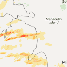
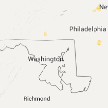
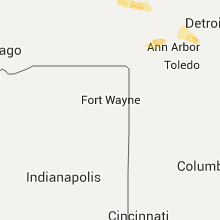
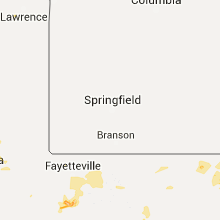
Hail Map for Friday, July 8, 2016

Number of Impacted Households on 7/8/2016
0
Impacted by 1" or Larger Hail
0
Impacted by 1.75" or Larger Hail
0
Impacted by 2.5" or Larger Hail
Square Miles of Populated Area Impacted on 7/8/2016
0
Impacted by 1" or Larger Hail
0
Impacted by 1.75" or Larger Hail
0
Impacted by 2.5" or Larger Hail


Cities Most Affected by Hail Storms of 7/8/2016
| Hail Size | Demographics of Zip Codes Affected | ||||||
|---|---|---|---|---|---|---|---|
| City | Count | Average | Largest | Pop Density | House Value | Income | Age |
| Bellaire, MI | 1 | 3.00 | 3.00 | 53 | $120k | $40.4k | 51.4 |
| East Jordan, MI | 1 | 3.00 | 3.00 | 47 | $90k | $38.6k | 43.4 |
| Glen Arbor, MI | 1 | 3.00 | 3.00 | 41 | $328k | $45.4k | 61.9 |
| Cushing, OK | 1 | 2.50 | 2.50 | 64 | $53k | $28.5k | 39.3 |
| Monument, CO | 1 | 2.50 | 2.50 | 691 | $270k | $87.9k | 42.8 |
| Alpena, MI | 1 | 2.00 | 2.00 | 109 | $80k | $34.2k | 45.6 |
| Lewiston, MI | 1 | 1.75 | 1.75 | 23 | $83k | $29.7k | 54.2 |
| Pinconning, MI | 1 | 1.75 | 1.75 | 73 | $79k | $40.3k | 43.7 |
| Stanley, NC | 1 | 1.75 | 1.75 | 342 | $98k | $41.4k | 40.7 |
| Empire, MI | 1 | 1.75 | 1.75 | 29 | $146k | $41.0k | 54.7 |
| Clarkrange, TN | 1 | 1.75 | 1.75 | 50 | $64k | $27.9k | 40.3 |
| Gamaliel, KY | 1 | 1.75 | 1.75 | 29 | $50k | $23.0k | 41.4 |
| Bentley, MI | 1 | 1.75 | 1.75 | 21 | $63k | $36.1k | 40.0 |
| Riverview, MI | 1 | 1.75 | 1.75 | 2293 | $0k | $0.0k | 43.3 |
| Central Lake, MI | 1 | 1.75 | 1.75 | 49 | $94k | $39.0k | 48.9 |
| Black Mountain, NC | 1 | 1.75 | 1.75 | 121 | $113k | $37.1k | 45.7 |
| Colorado Springs, CO | 1 | 1.75 | 1.75 | 3115 | $182k | $68.7k | 36.0 |
| Chandler, OK | 1 | 1.75 | 1.75 | 36 | $64k | $32.2k | 39.4 |
| Kalkaska, MI | 1 | 1.75 | 1.75 | 37 | $84k | $34.6k | 41.8 |
| Midland, TX | 1 | 1.75 | 1.75 | 2379 | $40k | $27.4k | 30.6 |
Hail and Wind Damage Spotted on 7/8/2016
Filter by Report Type:Hail ReportsWind Reports
States Impacted
Oklahoma, Kentucky, Indiana, Michigan, South Carolina, Ohio, West Virginia, Missouri, Florida, New Jersey, Virginia, Tennessee, New Mexico, Arkansas, Colorado, Wyoming, Texas, North Carolina, Georgia, New YorkOklahoma
| Local Time | Report Details |
|---|---|
| 7:45 AM CDT | Golf Ball sized hail reported near Chandler, OK, 39.6 miles ENE of Oklahoma City, OK, broadcast media showed a viewer photo. |
| 7:52 AM CDT | Quarter sized hail reported near Chandler, OK, 39.6 miles ENE of Oklahoma City, OK |
| 8:06 AM CDT | Storm damage reported in comanche county OK, 50.3 miles N of Wichita Falls, TX |
| 8:06 AM CDT | Storm damage reported in payne county OK, 44.5 miles WSW of Tulsa, OK |
| 8:20 AM CDT | Tennis Ball sized hail reported near Cushing, OK, 38 miles WSW of Tulsa, OK |
| 8:25 AM CDT | Several trees...limbs and power lines down. time estimated by rada in creek county OK, 33.2 miles W of Tulsa, OK |
| 8:35 AM CDT | Quarter sized hail reported near Drumright, OK, 37.8 miles WSW of Tulsa, OK, . |
| 8:38 AM CDT | Large tree blocking road. winds estimated at 60 to 70 mp in creek county OK, 20 miles W of Tulsa, OK |
| 9:00 AM CDT | Quarter sized hail reported near Okemah, OK, 52.5 miles SSW of Tulsa, OK, a few quarter size hail stones. mainly nickel size. |
| 9:30 AM CDT | Quarter sized hail reported near Collinsville, OK, 16.8 miles NNE of Tulsa, OK, report relayed by media via twitter. time estimated. |
| 4:45 PM CDT | Ping Pong Ball sized hail reported near Erick, OK, 55.9 miles NNE of Childress, TX |
| 5:10 PM CDT | 59 mph gust measured by el reno oklahoma mesonet in canadian county OK, 29.9 miles WNW of Oklahoma City, OK |
| 6:35 PM CDT | Storm damage reported in jackson county OK, 51.6 miles ENE of Childress, TX |
| 6:35 PM CDT | 2 inch tree limbs downed in greer county OK, 60.8 miles NE of Childress, TX |
| 7:10 PM CDT | Storm damage reported in pottawatomie county OK, 32.9 miles ESE of Oklahoma City, OK |
| 7:11 PM CDT | Storm damage reported in kiowa county OK, 76.4 miles ENE of Childress, TX |
| 7:34 PM CDT | 14 inch tree downed at broadway and 6th st in pottawatomie county OK, 24.4 miles E of Oklahoma City, OK |
| 7:35 PM CDT | Tree fell onto house at 9th and locust in pottawatomie county OK, 35.9 miles ESE of Oklahoma City, OK |
| 7:47 PM CDT | Estimated 60-65 mph in tillman county OK, 42.9 miles NW of Wichita Falls, TX |
| 7:50 PM CDT | Storm damage reported in tillman county OK, 42.8 miles NW of Wichita Falls, TX |
| 8:10 PM CDT | Quarter sized hail reported near Ada, OK, 54.5 miles SE of Oklahoma City, OK |
Kentucky
| Local Time | Report Details |
|---|---|
| 8:00 AM CDT | Storm damage reported in daviess county KY, 28.5 miles ESE of Evansville, IN |
| 8:02 AM CDT | Late report. barn blown down along curdsville delaware roa in daviess county KY, 28.5 miles ESE of Evansville, IN |
| 8:02 AM CDT | Late report. barn blown down along curdsville delaware roa in daviess county KY, 28.5 miles ESE of Evansville, IN |
| 8:03 AM CDT | Large tree fell and damaged roof awning on apartment buildin in daviess county KY, 21.6 miles SE of Evansville, IN |
| 8:10 AM CDT | Widespread tree damage with some homes damaged throughout the community. reported by fire chief while respondin in daviess county KY, 28.5 miles ESE of Evansville, IN |
| 8:20 AM CDT | Trees dow in hancock county KY, 44.2 miles E of Evansville, IN |
| 8:22 AM CDT | Tree reported down on car in hancock county KY, 36.4 miles E of Evansville, IN |
| 11:05 AM EDT | Tree reported dow in trimble county KY, 47.4 miles NNE of Louisville, KY |
| 11:27 AM EDT | Large tree fell through shed. time estimated by rada in carroll county KY, 46 miles SW of Cincinnati, OH |
| 11:28 AM EDT | Large limb down across mound hill road near hwy 55. a few large branches down in carrollton as wel in carroll county KY, 48.1 miles SW of Cincinnati, OH |
| 11:42 AM EDT | *** 2 inj *** 2 injuries from flying debri in gallatin county KY, 35.4 miles SW of Cincinnati, OH |
| 11:42 AM EDT | A tree down on smith ave. in warsa in gallatin county KY, 31 miles SW of Cincinnati, OH |
| 11:45 AM EDT | Trees dow in trimble county KY, 51.5 miles WSW of Cincinnati, OH |
| 11:45 AM EDT | Tree down. in trimble county KY, 51.2 miles WSW of Cincinnati, OH |
| 12:01 PM EDT | One tree dow in grant county KY, 29.3 miles S of Cincinnati, OH |
| 12:08 PM EDT | One large limb dow in boone county KY, 10.9 miles SW of Cincinnati, OH |
| 12:13 PM EDT | One tree down near turkey foot rd and colony d in kenton county KY, 7.8 miles SSW of Cincinnati, OH |
| 12:23 PM EDT | Trees and power lines down in clark county KY, 23.8 miles NNW of Irvine, KY |
| 12:45 PM EDT | Tree down on camargo levee r in montgomery county KY, 20.8 miles N of Irvine, KY |
| 12:45 PM EDT | Tree down on adams ridge roa in powell county KY, 11 miles N of Irvine, KY |
| 12:53 PM EDT | A few large branches down and one tree split at maysville country clu in mason county KY, 50.6 miles SE of Cincinnati, OH |
| 1:40 PM EDT | Trees blown down in the flatgap are in johnson county KY, 60.9 miles ENE of Irvine, KY |
| 1:54 PM EDT | A tree fell through a house per 911 dispatch. additionally...trees and powerlines have been reported down across roads throughout the county. time estimated from radar in greenup county KY, 59.8 miles WNW of Charleston, WV |
| 2:46 PM EDT | Trees reported down along reges road in estill county KY, 4.7 miles W of Irvine, KY |
| 2:52 PM EDT | Trees down along barns mountain road in estill county KY, 6.7 miles SE of Irvine, KY |
| 2:54 PM EDT | A few trees down in the town of lancaster. time estimated from rada in garrard county KY, 33.6 miles W of Irvine, KY |
| 2:59 PM EDT | Trees dow in garrard county KY, 28.8 miles W of Irvine, KY |
| 3:15 PM EDT | Tree blown down on old brodhead road. time estimated from rada in rockcastle county KY, 32 miles SW of Irvine, KY |
| 2:40 PM CDT | Golf Ball sized hail reported near Gamaliel, KY, 64.5 miles ENE of Nashville, TN, . |
| 2:40 PM CDT | Half Dollar sized hail reported near Tompkinsville, KY, 71.5 miles ENE of Nashville, TN, reported at celina road... tompkinsville... ky. |
| 4:40 PM EDT | Tree blown into a powerline in the tattersall portion of corbin. time estimated off rada in whitley county KY, 54.3 miles S of Irvine, KY |
| 4:45 PM EDT | Tree down on hous in laurel county KY, 32.4 miles S of Irvine, KY |
| 5:15 PM EDT | Trees blown down in the ambleside section of middlesboro. time estimated from rada in bell county KY, 46.2 miles NNE of Knoxville, TN |
| 6:10 PM CDT | Storm damage reported in carlisle county KY, 42 miles SE of Cape Girardeau, MO |
| 6:13 PM CDT | Storm damage reported in ballard county KY, 34.4 miles SE of Cape Girardeau, MO |
| 6:13 PM CDT | Storm damage reported in carlisle county KY, 42 miles SE of Cape Girardeau, MO |
| 6:15 PM CDT | Reports of multiple trees down across southern ballard county from just east of wickliffe toward lovelaceville... mainly south of hwy 28 in ballard county KY, 40.8 miles SE of Cape Girardeau, MO |
| 6:16 PM CDT | Uproot tree blocking highway 121 near the ballard carlisle county lin in ballard county KY, 40.8 miles SE of Cape Girardeau, MO |
| 6:18 PM CDT | Storm damage reported in ballard county KY, 34.4 miles SE of Cape Girardeau, MO |
| 6:20 PM CDT | Several reports of trees down across northern half of graves county including in the towns of hickory... fancy farm... melber... and folsomdale around 615 to 630p in graves county KY, 52.2 miles N of Mc Kenzie, TN |
| 6:25 PM CDT | Power lines down and stop lights out in mayfield in graves county KY, 42.5 miles N of Mc Kenzie, TN |
| 6:28 PM CDT | Large oak tree uprooted in graves county KY, 37.1 miles NNW of Mc Kenzie, TN |
| 6:30 PM CDT | Tree limbs down along state route 303 in graves county KY, 32.2 miles NNW of Mc Kenzie, TN |
| 6:32 PM CDT | Large tree over husbands roa in mccracken county KY, 52.4 miles ESE of Cape Girardeau, MO |
| 6:50 PM CDT | Multiple trees uproote in calloway county KY, 40.7 miles NNE of Mc Kenzie, TN |
| 7:03 PM CDT | Dime size hail reported with this storm as wel in christian county KY, 63.1 miles NW of Nashville, TN |
| 7:15 PM CDT | Multiple trees down on linton roa in trigg county KY, 50.9 miles NE of Mc Kenzie, TN |
| 7:37 PM CDT | Numerous trees down. madisonville road and hwy 189 are blocked. barn leveled. widespread power outages reported across the northern half of the count in christian county KY, 61.5 miles NW of Nashville, TN |
| 7:40 PM CDT | Tree down on power line on plum street and another tree down on annett court on east side of town. around 2500 customers are without power in christian count in christian county KY, 60.1 miles NW of Nashville, TN |
| 8:03 PM CDT | Widespread trees down throughout the county. power lines down in greenville. near continuous lightnin in muhlenberg county KY, 56.9 miles SSE of Evansville, IN |
| 8:14 PM CDT | Trees and power lines dow in logan county KY, 47.4 miles N of Nashville, TN |
| 8:14 PM CDT | Two trees down in elkton with winds at 60 mp in todd county KY, 49.1 miles NNW of Nashville, TN |
| 8:30 PM CDT | Widespread trees down throughout the county. power lines down in greenville. near continuous lightnin in muhlenberg county KY, 56.9 miles SSE of Evansville, IN |
| 8:49 PM CDT | Power line down at a residence reported at n tyler street... morgantown... k in butler county KY, 70.8 miles SE of Evansville, IN |
| 8:59 PM CDT | Trees down countywid in allen county KY, 48.6 miles NE of Nashville, TN |
Indiana
| Local Time | Report Details |
|---|---|
| 8:30 AM CDT | A couple of trees reported dow in perry county IN, 43.9 miles E of Evansville, IN |
| 10:30 AM EDT | Trees reported dow in harrison county IN, 27.2 miles NW of Louisville, KY |
| 10:30 AM EDT | Trees reported dow in harrison county IN, 36.5 miles NW of Louisville, KY |
| 10:30 AM EDT | Tree dow in crawford county IN, 43.4 miles NW of Louisville, KY |
| 10:35 AM EDT | Large tree top falle in floyd county IN, 23.1 miles NNW of Louisville, KY |
| 10:40 AM EDT | Tree down on hous in crawford county IN, 43.4 miles NW of Louisville, KY |
| 10:45 AM EDT | Trees reported dow in floyd county IN, 22.9 miles NNW of Louisville, KY |
| 11:00 AM EDT | Trees reported dow in clark county IN, 28.5 miles N of Louisville, KY |
| 11:15 AM EDT | Trees reported dow in jefferson county IN, 52.3 miles NNE of Louisville, KY |
| 11:20 AM EDT | Trees reported dow in washington county IN, 47.7 miles NNW of Louisville, KY |
| 11:22 AM EDT | Trees reported dow in washington county IN, 39.6 miles NNW of Louisville, KY |
| 11:25 AM EDT | Trees reported dow in jefferson county IN, 52.9 miles WSW of Cincinnati, OH |
| 11:30 AM EDT | Trees down on alder roa in jefferson county IN, 50.3 miles WSW of Cincinnati, OH |
| 11:36 AM EDT | Several trees down across roadways. time estimated from rada in switzerland county IN, 35 miles WSW of Cincinnati, OH |
| 11:40 AM EDT | Trees down over roadways. time estimated from rada in switzerland county IN, 31.8 miles WSW of Cincinnati, OH |
| 11:40 AM EDT | Trees and power pole dow in jefferson county IN, 52.2 miles WSW of Cincinnati, OH |
| 12:17 PM EDT | Tree and power pole down across sr 35 in ripley county IN, 39.6 miles W of Cincinnati, OH |
| 12:23 PM EDT | Tree down across sr 101 near co rd 900 in ripley county IN, 32.1 miles WNW of Cincinnati, OH |
| 12:27 PM EDT | Siding and portion of outer wall sheathing ripped off side of hous in dearborn county IN, 29.3 miles WNW of Cincinnati, OH |
| 7:32 PM EDT | Trees down... transformers blow in harrison county IN, 36.6 miles NW of Louisville, KY |
Michigan
| Local Time | Report Details |
|---|---|
| 10:50 AM EDT | Golf Ball sized hail reported near Empire, MI, 22.1 miles W of Traverse City, MI |
| 10:51 AM EDT | Quarter sized hail reported near Traverse City, MI, 1 miles SE of Traverse City, MI |
| 10:55 AM EDT | Quarter sized hail reported near Traverse City, MI, 1 miles SE of Traverse City, MI |
| 10:58 AM EDT | Tea Cup sized hail reported near Glen Arbor, MI, 21.2 miles WNW of Traverse City, MI |
| 11:04 AM EDT | Multiple trees down and roads closed near bunker hill rd and supply rd in grand traverse county MI, 10.6 miles E of Traverse City, MI |
| 11:06 AM EDT | Quarter sized hail reported near Cooks, MI, 61.8 miles SE of Marquette, MI, at least 1 inch hail estimated. observer arrived on site around 30 minutes after hail was estimated to have fallen...based on radar...and found nickel size hail coverin |
| 11:17 AM EDT | Ping Pong Ball sized hail reported near Cedar, MI, 12.7 miles NW of Traverse City, MI |
| 11:20 AM EDT | Quarter sized hail reported near Rapid City, MI, 16.7 miles E of Traverse City, MI |
| 11:35 AM EDT | Golf Ball sized hail reported near Kalkaska, MI, 35.7 miles E of Traverse City, MI |
| 11:40 AM EDT | Quarter sized hail reported near Suttons Bay, MI, 15.3 miles N of Traverse City, MI |
| 11:44 AM EDT | Ping Pong Ball sized hail reported near Elmira, MI, 38 miles ENE of Traverse City, MI, manistee lakes area |
| 11:44 AM EDT | Ping Pong Ball sized hail reported near Kalkaska, MI, 31.3 miles E of Traverse City, MI, manistee lakes area |
| 11:49 AM EDT | Tea Cup sized hail reported near East Jordan, MI, 36.5 miles NE of Traverse City, MI |
| 11:52 AM EDT | Half Dollar sized hail reported near East Jordan, MI, 36.9 miles NE of Traverse City, MI |
| 12:00 PM EDT | Quarter sized hail reported near Central Lake, MI, 27.6 miles NE of Traverse City, MI, 1.00 inch of rain in 20 minutes |
| 12:15 PM EDT | Ping Pong Ball sized hail reported near Gaylord, MI, 44.1 miles E of Traverse City, MI |
| 12:43 PM EDT | Quarter sized hail reported near Bellaire, MI, 25 miles NE of Traverse City, MI |
| 12:45 PM EDT | Ping Pong Ball sized hail reported near Bellaire, MI, 25 miles NE of Traverse City, MI |
| 12:45 PM EDT | Quarter sized hail reported near Suttons Bay, MI, 17.3 miles N of Traverse City, MI, 1.29 inches of rain |
| 12:48 PM EDT | Tea Cup sized hail reported near Bellaire, MI, 25 miles NE of Traverse City, MI |
| 12:49 PM EDT | Quarter sized hail reported near Lewiston, MI, 45.3 miles WSW of Alpena, MI |
| 12:49 PM EDT | Golf Ball sized hail reported near Central Lake, MI, 27.3 miles NE of Traverse City, MI |
| 1:00 PM EDT | Golf Ball sized hail reported near Lewiston, MI, 44.7 miles WSW of Alpena, MI |
| 1:11 PM EDT | Quarter sized hail reported near Atlanta, MI, 36.1 miles W of Alpena, MI |
| 1:11 PM EDT | Quarter sized hail reported near Lake, MI, 64.3 miles SSE of Traverse City, MI, observer also reports strong winds. |
| 1:18 PM EDT | Quarter sized hail reported near Atlanta, MI, 34.8 miles W of Alpena, MI |
| 1:20 PM EDT | Quarter sized hail reported near Negaunee, MI, 10.3 miles WSW of Marquette, MI, observed quarter sized hail near negaunee this afternoon. delayed report via social media. |
| 1:44 PM EDT | Ping Pong Ball sized hail reported near Hillman, MI, 22.8 miles WSW of Alpena, MI |
| 1:45 PM EDT | Quarter sized hail reported near Lake City, MI, 35.2 miles SE of Traverse City, MI, . |
| 1:50 PM EDT | Quarter sized hail reported near Lake City, MI, 35.8 miles SE of Traverse City, MI |
| 2:09 PM EDT | Storm damage reported in montmorency county MI, 44.7 miles WSW of Alpena, MI |
| 2:20 PM EDT | Damage to farm buildings in alpena county MI, 9.1 miles SW of Alpena, MI |
| 2:27 PM EDT | Hen Egg sized hail reported near Alpena, MI, 0.6 miles NNE of Alpena, MI |
| 2:30 PM EDT | Damage to several tree in roscommon county MI, 53.9 miles ESE of Traverse City, MI |
| 2:41 PM EDT | Trees down in alpena county MI, 0.6 miles NNE of Alpena, MI |
| 2:42 PM EDT | Multiple trees reported down in sheridan twp east of clare. time estimated from rada in clare county MI, 76.3 miles NW of Flint, MI |
| 2:57 PM EDT | Camper blown over. roof peeled off of out buildin in alcona county MI, 18 miles SW of Alpena, MI |
| 3:00 PM EDT | Golf Ball sized hail reported near Bentley, MI, 69.1 miles NNW of Flint, MI |
| 3:07 PM EDT | Ping Pong Ball sized hail reported near Standish, MI, 68.3 miles NNW of Flint, MI, . |
| 3:10 PM EDT | Storm damage reported in alpena county MI, 10.5 miles S of Alpena, MI |
| 3:11 PM EDT | Storm damage reported in alpena county MI, 10.5 miles S of Alpena, MI |
| 3:15 PM EDT | Several trees and power lines down from worth to northeast of standis in arenac county MI, 67.6 miles NNW of Flint, MI |
| 3:30 PM EDT | Trees down in midland county MI, 61 miles NW of Flint, MI |
| 3:42 PM EDT | Severe wind and nickle size hail in bay county MI, 60.5 miles N of Flint, MI |
| 3:42 PM EDT | Golf Ball sized hail reported near Pinconning, MI, 59.7 miles NNW of Flint, MI, marathon gas station |
| 3:42 PM EDT | Roof peeled off... trees snapped... and windows blown out in bay county MI, 61.8 miles N of Flint, MI |
| 3:56 PM EDT | Several trees were downed on private property just off m-21. resident reported that a branch impaled a garage wall. resident also stated that there is tree damage at be in ionia county MI, 28 miles E of Grand Rapids, MI |
| 3:56 PM EDT | Trees reported down over m-21 just west of the prison near ioni in ionia county MI, 28.5 miles E of Grand Rapids, MI |
| 3:58 PM EDT | Power lines reported down in ionia in ionia county MI, 31 miles E of Grand Rapids, MI |
| 4:00 PM EDT | Three fruit trees of aprox. 6 inch diameter were uprooted this afternoon. estimated time close to 4:00 p.m. edt. delayed report in schoolcraft county MI, 65.7 miles SE of Marquette, MI |
| 4:29 PM EDT | Quarter sized hail reported near Bay City, MI, 39.7 miles NNW of Flint, MI, via facebook photo |
| 4:40 PM EDT | Quarter sized hail reported near Bay City, MI, 41.3 miles NNW of Flint, MI |
| 4:41 PM EDT | Big trees down and numerous wires down sebewaing to bay port. via dispatc in huron county MI, 51.1 miles NNE of Flint, MI |
| 4:42 PM EDT | Healthy pine tree 4 feet in diameter snapped about 12 feet off the ground doing damage to power lines. one home was reported as being evacuated. delta twp fire is on th in clinton county MI, 46 miles ESE of Grand Rapids, MI |
| 4:44 PM EDT | Large branches down. wind gust estimated around 50 mp in huron county MI, 60.3 miles NNE of Flint, MI |
| 4:44 PM EDT | Quarter sized hail reported near Bay City, MI, 41.3 miles NNW of Flint, MI |
| 4:50 PM EDT | Em reports scattered areas with power lines and tree branches down across the southern end of the county. time estimated by rada in clinton county MI, 46 miles ESE of Grand Rapids, MI |
| 4:54 PM EDT | Tree blown over onto power lines near wright road and clark road in eagle. public report via social medi in clinton county MI, 48.5 miles ESE of Grand Rapids, MI |
| 4:57 PM EDT | Large trees down blocking roads...numerous power lines down across n. sanilac count in sanilac county MI, 53.4 miles NE of Flint, MI |
| 4:58 PM EDT | Spotter noted damage to an awning on his neighbors home. a utility shed was blown from the yard into another neighbors yard. a nine inch tree limb was broken from a tre in clinton county MI, 46.4 miles WSW of Flint, MI |
| 5:05 PM EDT | Pictures sent by the em. large tree down across the road near the intersection of okemos road and raby roa in ingham county MI, 42.1 miles WSW of Flint, MI |
| 5:08 PM EDT | Half inch hail and wind gusts estimated near 60 mph in ingham county MI, 42.8 miles WSW of Flint, MI |
| 5:10 PM EDT | Large branches and powerline down in shiawassee county MI, 30.6 miles WSW of Flint, MI |
| 5:13 PM EDT | Quarter sized hail reported near Lansing, MI, 45.2 miles WSW of Flint, MI, em relayed report from the public |
| 5:14 PM EDT | 2 ft diameter tree down at schwegler and daus...limb on wires at forestville rd and van dyke in tuscola county MI, 50.9 miles NNE of Flint, MI |
| 5:14 PM EDT | Max thunderstorm wind gust recorded at lansing capital airpor in clinton county MI, 48.6 miles WSW of Flint, MI |
| 5:20 PM EDT | Approximately the top 10 feet of a 30 feet pine was snapped off. winds were estimate around 50 mp in clinton county MI, 50.2 miles E of Grand Rapids, MI |
| 5:25 PM EDT | Tree approximately 10 inches in diameter reported down. emergency manager relayed this report from a trained storm spotte in ingham county MI, 44.4 miles WSW of Flint, MI |
| 6:00 PM EDT | Large trees down blocking roads. power lines down. via tuscola county dispatc in tuscola county MI, 37.2 miles NE of Flint, MI |
| 7:00 PM EDT | 8 inch diameter tree down blocking road at chubb and 6 mil in washtenaw county MI, 41.8 miles S of Flint, MI |
| 7:02 PM EDT | Numerous trees and limbs down at ridge and n territorial in plymouth twp in wayne county MI, 44.3 miles S of Flint, MI |
| 7:08 PM EDT | Large dead branches down at haggerty and ecorse in van buren twp in wayne county MI, 53.9 miles SSE of Flint, MI |
| 7:15 PM EDT | Gas station canopy collapsed on top of cars in wayne county MI, 50.2 miles SSE of Flint, MI |
| 7:26 PM EDT | Trees up to 1 foot diameter snapped. numerous medium to large branches dow in wayne county MI, 57.9 miles SSE of Flint, MI |
| 7:27 PM EDT | Allen parl...reeck and goddard...large trees down over a foot in diameter. power out. four homes in a row with large trees down. trees blocking roa in wayne county MI, 58.9 miles SSE of Flint, MI |
| 7:28 PM EDT | Trees snapped and uprooted in wayne county MI, 60 miles SSE of Flint, MI |
| 7:30 PM EDT | Power lines down on riverview street and west jefferson in wayne county MI, 63.3 miles SSE of Flint, MI |
| 7:30 PM EDT | Power lines down on riverview street and west jefferson in wayne county MI, 63.3 miles SSE of Flint, MI |
| 7:30 PM EDT | Large tree limbs down at 16th and pine streets...also several trees down at 17th and orchard street in wayne county MI, 61.4 miles SSE of Flint, MI |
| 7:30 PM EDT | Top of large tree...18 inch diameter...blown off in strong wind....on morle in wayne county MI, 54.1 miles SSE of Flint, MI |
| 7:30 PM EDT | Wind speed estimated at 65 mph...hail estimated at 1 inc in wayne county MI, 56.3 miles SSE of Flint, MI |
| 7:35 PM EDT | Large limbs down...downed power lines...major ponding on roadways...allen rd and eureka rd in wayne county MI, 60.6 miles SSE of Flint, MI |
| 7:36 PM EDT | Golf Ball sized hail reported near Riverview, MI, 63.3 miles SSE of Flint, MI, hail est. wind est. at 60 mph. torrential downpour. intersection of hale and fort rd. |
South Carolina
| Local Time | Report Details |
|---|---|
| 11:47 AM EDT | Report of tree down on pleasantdale rd between sc 76 and sc 9. time estimated by rada in horry county SC, 66.1 miles W of Wilmington, NC |
| 8:00 PM EDT | Several trees down along 176 and tinker creek roa in union county SC, 59.7 miles ESE of Greenville, SC |
| 8:39 PM EDT | Numerous powerlines dow in oconee county SC, 22 miles W of Greenville, SC |
| 8:45 PM EDT | Schp reported a tree down at gap hill rd and cofferdam rd in pickens county SC, 15.3 miles W of Greenville, SC |
| 8:45 PM EDT | Schp reported a tree down at geer highway and fire tower rd in greenville county SC, 17.3 miles NNE of Greenville, SC |
| 8:45 PM EDT | Schp reported a tree down at mccarson rd and river falls rd in greenville county SC, 18.2 miles N of Greenville, SC |
| 8:45 PM EDT | Downed tree blocking lyman lake rd in spartanburg county SC, 26.1 miles ENE of Greenville, SC |
| 8:50 PM EDT | Trees down across hampton roa in spartanburg county SC, 27.6 miles ENE of Greenville, SC |
| 9:05 PM EDT | Schp reported a tree down at melton rd and highway 88 in anderson county SC, 9 miles SSW of Greenville, SC |
| 9:08 PM EDT | Schp reported a tree down at elrod rd and sleepy hollow rd in anderson county SC, 9.4 miles SE of Greenville, SC |
| 9:10 PM EDT | Mping report of large brances and power poles downed in york county SC, 27 miles SW of Charlotte, NC |
| 9:15 PM EDT | Trees down across roadways in york county SC, 22.3 miles SSW of Charlotte, NC |
| 10:01 PM EDT | Reported numerous trees and power lines in and around the town of cheraw. many areas without power. in chesterfield county SC, 64.2 miles SE of Charlotte, NC |
| 10:01 PM EDT | Reported trees and power lines down between chesterfield and cheraw. other reports of strong winds in the area. in chesterfield county SC, 57.4 miles SE of Charlotte, NC |
| 10:02 PM EDT | Reported a few trees down along with one power line down in the area of mt. bethel garmany road and hwy. 176. in newberry county SC, 66.5 miles NNE of Augusta, GA |
| 10:05 PM EDT | Trees down along highway 176 and tinker creek roa in union county SC, 59.7 miles ESE of Greenville, SC |
| 10:13 PM EDT | Report of trees down across bennettsville. time estimated by rada in marlboro county SC, 76.9 miles ESE of Charlotte, NC |
| 10:29 PM EDT | Report of two trees down at intersection of hebron dunbar...hebron church...and manning farm road. time estimated by rada in marlboro county SC, 83.6 miles ESE of Charlotte, NC |
| 10:29 PM EDT | Report of tree down at intersection of coxe rd and sandy grove church rd. time estimated by rada in marlboro county SC, 82.4 miles ESE of Charlotte, NC |
| 10:32 PM EDT | Reported a few trees down along with one power line down in the area of mt. bethel garmany road and hwy. 176. in newberry county SC, 66.5 miles NNE of Augusta, GA |
| 10:33 PM EDT | Reported trees down near mt. bethel garmany road and miles roa in newberry county SC, 61.4 miles NNE of Augusta, GA |
| 10:39 PM EDT | Reported several trees and power lines down between the town of chesterfield and the north carolina line. in chesterfield county SC, 53.2 miles SE of Charlotte, NC |
| 10:55 PM EDT | Report of tree down at intersection of stonaway st and west main st. time estimated by rada in marlboro county SC, 77.2 miles ESE of Charlotte, NC |
| 11:19 PM EDT | Report of tree in roadway at intersection of south santiago dr and w palmetto st. time estimated by rada in florence county SC, 68.7 miles N of Charleston, SC |
| 11:19 PM EDT | Report of tree in roadway on i-95 at mile marker 191. time estimated by rada in dillon county SC, 84.2 miles W of Wilmington, NC |
| 11:22 PM EDT | Report of tree down at intersection of w sellers rd and us 501. time estimated by rada in marion county SC, 80.1 miles NNE of Charleston, SC |
| 11:30 PM EDT | Trees down along woodlawn roa in edgefield county SC, 9.8 miles NNW of Augusta, GA |
| 11:35 PM EDT | Trees down near mealing road and sweetwater roa in edgefield county SC, 9 miles N of Augusta, GA |
| 11:37 PM EDT | Report of tree down on sc 41a near t mart. time estimated by rada in marion county SC, 73.4 miles NNE of Charleston, SC |
| 11:38 PM EDT | Sc highway patrol reported trees in the roadway on brewer springs rd. at hwy 34. time estimated by rada in kershaw county SC, 70.1 miles SSE of Charlotte, NC |
| 11:44 PM EDT | Report of tree down on pee dee hwy near frye rd. time estimated by rada in horry county SC, 72.6 miles W of Wilmington, NC |
| 11:47 PM EDT | Report of tree down on pleasantdale rd between sc 76 and sc 9. time estimated by rada in horry county SC, 66.1 miles W of Wilmington, NC |
| 11:53 PM EDT | Trees down on the northwest side of the city of aiken in the vicinity of vaucluse road and trolley line roa in aiken county SC, 14.5 miles NE of Augusta, GA |
| 11:54 PM EDT | Trees down near pine log road and key plantation roa in aiken county SC, 9 miles E of Augusta, GA |
| 12:00 AM EDT | Report of tree down at the intersection of green sea rd and cascade rd. time estimated by rada in horry county SC, 55.7 miles W of Wilmington, NC |
| 12:06 AM EDT | Tree down on red bluff rd. time estimated by rada in horry county SC, 55.7 miles WSW of Wilmington, NC |
| 12:27 AM EDT | Report of tree down at the intersection of w john paul jones rd and savannah grove rd. time estimated by rada in florence county SC, 63.9 miles N of Charleston, SC |
| 1:40 AM EDT | Tree down across mill pond road near mount carmel road. time estimated based on rada in colleton county SC, 46.2 miles WSW of Charleston, SC |
| 2:03 AM EDT | Tree down near the intersection of the charleston highway and smoak road. time estimated based on radar and nearby surface observations from the walterboro airpor in colleton county SC, 41.6 miles WSW of Charleston, SC |
Ohio
| Local Time | Report Details |
|---|---|
| 12:40 PM EDT | Multiple trees down in batavia twnshp. time estimated by rada in clermont county OH, 17.5 miles E of Cincinnati, OH |
| 12:40 PM EDT | Tree down along e. cherry st. near bethel. time estimated by rada in clermont county OH, 25.5 miles ESE of Cincinnati, OH |
| 12:51 PM EDT | One tree down at sr 41 and sr 76 in brown county OH, 50.6 miles SE of Cincinnati, OH |
| 12:55 PM EDT | One tree down closing sr 763 at sr 12 in brown county OH, 46.7 miles ESE of Cincinnati, OH |
| 1:29 PM EDT | A power pole down on brouses run rd. also multiple trees down around friendship and west portsmout in scioto county OH, 80.9 miles WNW of Charleston, WV |
| 1:35 PM EDT | Three trees and powerlines down at rosemount rd and sr 13 in scioto county OH, 76.4 miles WNW of Charleston, WV |
| 1:45 PM EDT | Large tree down over oakes roa in scioto county OH, 67.2 miles WNW of Charleston, WV |
| 1:54 PM EDT | Trees down along cr 52 at mile marker 1. time estimated from radar in lawrence county OH, 62.8 miles WNW of Charleston, WV |
| 1:58 PM EDT | Trees and power lines down on sr 93 at mile marker 15. time estimated from radar in lawrence county OH, 61.3 miles WNW of Charleston, WV |
| 2:00 PM EDT | Trees and power lines down along sr 93 at mile marker 2. time estimated from radar in lawrence county OH, 56.5 miles WNW of Charleston, WV |
West Virginia
| Local Time | Report Details |
|---|---|
| 2:40 PM EDT | Trees down on booten creek road. time estimated from rada in cabell county WV, 37 miles W of Charleston, WV |
| 2:45 PM EDT | Trees down in town in mingo county WV, 56.5 miles SW of Charleston, WV |
| 2:50 PM EDT | Trees down in west hamlin. time estimated from rada in lincoln county WV, 30.9 miles W of Charleston, WV |
| 2:54 PM EDT | Tree down on mud river road near myra in lincoln county WV, 27.1 miles WSW of Charleston, WV |
| 3:00 PM EDT | Trees down along route 44. time estimated from rada in logan county WV, 40.3 miles SSW of Charleston, WV |
| 3:05 PM EDT | Trees down in wharncliffe in mingo county WV, 57.4 miles SSW of Charleston, WV |
| 3:07 PM EDT | Tree down on 6 mile road in danville. time estimated from rada in boone county WV, 21.3 miles SSW of Charleston, WV |
| 3:08 PM EDT | Trees down on spruce river road in boone county WV, 21.8 miles SSW of Charleston, WV |
| 3:15 PM EDT | Trees down in man in logan county WV, 43.9 miles SSW of Charleston, WV |
| 3:20 PM EDT | Trees down along route 85. time estimated from rada in wyoming county WV, 41.6 miles S of Charleston, WV |
| 3:28 PM EDT | Numerous reports of trees down across wyoming county including along rt.97 rt.99 rt.1 in wyoming county WV, 53.5 miles S of Charleston, WV |
| 3:34 PM EDT | Trees down in mullens area. time estimated from rada in wyoming county WV, 54.8 miles SSE of Charleston, WV |
| 3:44 PM EDT | Trees down in parking lot of mariott courtyard. photos sent of a tree over 1 foot in diamger down on a car causing significant damage. time estimated from rada in raleigh county WV, 44.9 miles SSE of Charleston, WV |
| 3:47 PM EDT | Tree down on a house in crab orchard. time estimated from rada in raleigh county WV, 47.6 miles SSE of Charleston, WV |
| 3:48 PM EDT | Estimated gust of 60mph on interstate 64 near exit 121. time estimated from rada in raleigh county WV, 49.3 miles SSE of Charleston, WV |
| 3:50 PM EDT | Quarter sized hail reported near Lashmeet, WV, 66.6 miles SSE of Charleston, WV, quarter sized hail near the intersection of beeson road and cole farm road |
| 3:51 PM EDT | Over 100 reports of wind incidents throughout raleigh county. trees down on a church and on a house. numerous trees down in beckley... beaver... and daniel in raleigh county WV, 48.2 miles SE of Charleston, WV |
| 3:52 PM EDT | One tree limb down that damaged the canopy of a camper in mercer county WV, 64.7 miles SSE of Charleston, WV |
| 3:55 PM EDT | One tree down at the intersection of airport road and stoney ridge road in mercer county WV, 70.5 miles W of Roanoke, VA |
| 3:57 PM EDT | One tree down at the intersection of airport road and shermanoaks road in mercer county WV, 67.2 miles W of Roanoke, VA |
| 4:05 PM EDT | A tree was blown down onto a car along route 20 near the community of pipestem. this report was submitted by a memeber of the public and relayed through local medi in summers county WV, 59.1 miles WNW of Roanoke, VA |
| 4:19 PM EDT | Numerous trees down across the county that started at 419 pm and ended at 441 pm...including along routes 12 and 219 in monroe county WV, 38.8 miles WNW of Roanoke, VA |
| 4:20 PM EDT | A large tree limb was blown down in the community of pickaway. this report was submitted by a member of the public and relayed by local medi in monroe county WV, 40.3 miles NW of Roanoke, VA |
| 4:30 PM EDT | A tree was blown down blocking highway 2 in greenbrier county WV, 57.6 miles NW of Roanoke, VA |
Missouri
| Local Time | Report Details |
|---|---|
| 1:53 PM CDT | Numerous trees and tree limbs down in the burlington subdivision. several roofs damaged...along with damage to siding and fencing. time estimated from rada in stone county MO, 33.4 miles S of Springfield, MO |
| 2:10 PM CDT | Multiple trees down along highway 160 in northern taney county in taney county MO, 33.5 miles S of Springfield, MO |
| 2:30 PM CDT | Tree blocking hwy t near hwy in douglas county MO, 33.7 miles SE of Springfield, MO |
| 2:40 PM CDT | Several tree limbs down around av in douglas county MO, 39.2 miles ESE of Springfield, MO |
| 3:09 PM CDT | Pole barn blown down near the intersection of hwy 14 and hwy 9 in douglas county MO, 56.8 miles ESE of Springfield, MO |
| 3:41 PM CDT | Estimated 60 mph winds at troop g headquarter in howell county MO, 50.6 miles SSW of Salem, MO |
| 4:18 PM CDT | Law enforcement reports numerous trees down around the town of winona. time estimated by rada in shannon county MO, 44.8 miles SSE of Salem, MO |
| 4:20 PM CDT | Law enforcement reported trees down in the blue spring area in eastern shannon county. time estimated by rada in shannon county MO, 38.3 miles SSE of Salem, MO |
| 4:35 PM CDT | Numerous trees down and a power line dow in carter county MO, 52 miles SE of Salem, MO |
| 5:10 PM CDT | Numerous trees down. between 50 to 60 phone calls to sheriffs office regarding trees down in carter count in carter county MO, 65.2 miles SE of Salem, MO |
| 5:25 PM CDT | Large tree down. wind gust associated with this storm was measured at 47 mp in butler county MO, 60.7 miles SW of Cape Girardeau, MO |
| 5:50 PM CDT | Trees dow in mississippi county MO, 35.3 miles SSE of Cape Girardeau, MO |
Florida
| Local Time | Report Details |
|---|---|
| 3:38 PM EDT | Quarter sized hail reported near Pembroke Pines, FL, 20.4 miles NNW of Miami, FL |
New Jersey
| Local Time | Report Details |
|---|---|
| 3:50 PM EDT | Trees down. time estimated from rada in morris county NJ, 37 miles WNW of Brooklyn, NY |
| 3:55 PM EDT | Multiple trees down. time estimated from radar in morris county NJ, 41.2 miles WNW of Brooklyn, NY |
| 4:00 PM EDT | Trees down. time estimated from radar in morris county NJ, 40.3 miles WNW of Brooklyn, NY |
| 4:00 PM EDT | Some trees down. time estimated from rada in morris county NJ, 38.3 miles WNW of Brooklyn, NY |
| 4:06 PM EDT | Multiple trees down. time estimated from radar in morris county NJ, 37.3 miles W of Brooklyn, NY |
| 4:10 PM EDT | Multiple trees down. time estimated from radar in morris county NJ, 32.6 miles W of Brooklyn, NY |
| 4:40 PM EDT | Tree limbs down. time estimated from rada in atlantic county NJ, 84.5 miles SSW of Brooklyn, NY |
| 4:45 PM EDT | Large tree limbs down. time estimated from rada in atlantic county NJ, 84.3 miles NNE of Ocean City, MD |
Virginia
| Local Time | Report Details |
|---|---|
| 3:52 PM EDT | Two power poles down on angel lane in tazewell county VA, 69.7 miles NE of Bristol, TN |
| 4:15 PM EDT | A large tree was blown down. this report was submitted by a member of the public and relayed through local medi in giles county VA, 49.2 miles W of Roanoke, VA |
| 4:41 PM EDT | One tree down near the intersection of prices fork road and merrimac road in montgomery county VA, 29.4 miles W of Roanoke, VA |
| 4:45 PM EDT | Numerous trees down across the county with many power outages reported. storms crossed the county from about 440 pm to 500 pm per rada in craig county VA, 18.6 miles NNW of Roanoke, VA |
| 5:05 PM EDT | 2 trees down in catawba. one fell on the house and damaged an ac uni in roanoke county VA, 12.4 miles NW of Roanoke, VA |
| 5:05 PM EDT | Two trees were blown down along with large limbs from several other tree in roanoke county VA, 8.7 miles NNW of Roanoke, VA |
| 5:05 PM EDT | Multiple large trees were blown down near the intersection of maggie lane and poor mountain roa in roanoke county VA, 11.6 miles WSW of Roanoke, VA |
| 5:07 PM EDT | Multiple trees were blown down across the community of dalevill in botetourt county VA, 10.3 miles N of Roanoke, VA |
| 5:08 PM EDT | 60 mph gust measured at roanoke regional airport in city of roanoke county VA, 4.6 miles NNW of Roanoke, VA |
| 5:09 PM EDT | Trees snapped and blown down on olsen road. report from wfxr-t in roanoke county VA, 5.8 miles NNW of Roanoke, VA |
| 5:10 PM EDT | Thunderstorm winds blew down a large tree branch on nover avenue. report from wfxr-t in roanoke county VA, 5 miles NNW of Roanoke, VA |
| 5:10 PM EDT | Multiple trees were blown down across the community of troutvill in botetourt county VA, 10.1 miles NNE of Roanoke, VA |
| 5:14 PM EDT | Tree blown down by thunderstorm winds on franklin pik in floyd county VA, 23.8 miles SSW of Roanoke, VA |
| 5:15 PM EDT | Tree blown down by thunderstorm winds on cypress road southeas in floyd county VA, 23.5 miles SSW of Roanoke, VA |
| 5:15 PM EDT | Multiple trees were blown down across the community of blue ridg in botetourt county VA, 10 miles NE of Roanoke, VA |
| 5:15 PM EDT | Multiple limbs at least 12 inches in diameter were blown dow in roanoke county VA, 5 miles E of Roanoke, VA |
| 5:20 PM EDT | One tree two feet in diameter was blown down and was blocking part of turner branch roa in bedford county VA, 7.2 miles E of Roanoke, VA |
| 5:20 PM EDT | Thunderstorm winds resulted in a tree down in the northern portion of the community of hillsville... v in carroll county VA, 55.3 miles SW of Roanoke, VA |
| 5:30 PM EDT | Two trees and numerous large branches blown down by thunderstorm wind in pittsylvania county VA, 39 miles ESE of Roanoke, VA |
| 5:30 PM EDT | One tree blown down by thunderstorm winds on little snake creek roa in carroll county VA, 55 miles SW of Roanoke, VA |
| 5:35 PM EDT | Multiple large trees were blown down in the community of basset in henry county VA, 34.7 miles S of Roanoke, VA |
| 5:50 PM EDT | A large tree was blown down onto a fenc in pittsylvania county VA, 29.3 miles SE of Roanoke, VA |
| 5:55 PM EDT | Multiple trees were blown down in the community of axto in henry county VA, 43.2 miles SSE of Roanoke, VA |
| 5:55 PM EDT | A tree was blown down onto a home along friendly church roa in henry county VA, 43.6 miles S of Roanoke, VA |
| 6:00 PM EDT | Social media report of several large trees down in the community of chatham... v in pittsylvania county VA, 43.2 miles SE of Roanoke, VA |
| 6:02 PM EDT | Thunderstorm winds blew down a tree on a home on friendly church road. henry county dispatch reports widespread wind damage across the county from bassett to axton. tim in henry county VA, 43.6 miles S of Roanoke, VA |
| 6:05 PM EDT | Two trees and numerous large branches blown down by thunderstorm wind in pittsylvania county VA, 39 miles ESE of Roanoke, VA |
| 6:27 PM EDT | Social media report of a tree down along west main street in the city of danville... v in city of danville county VA, 56 miles SSE of Roanoke, VA |
| 6:45 PM EDT | Report from wset-tv...several large tree limbs blown down. time estimated from rada in halifax county VA, 64.7 miles NNW of Raleigh, NC |
| 6:47 PM EDT | Quarter sized hail reported near Chesapeake, VA, 11.6 miles WNW of Virginia Beach, VA, quarter size hail. |
| 6:54 PM EDT | Tree down on interstate 85 mile marker 13 in mecklenburg county VA, 59.7 miles SSW of Richmond, VA |
| 7:06 PM EDT | Tree down at airport road in mecklenburg county VA, 65.9 miles SW of Richmond, VA |
| 7:13 PM EDT | Tree down on evergreen road in mecklenburg county VA, 57.7 miles N of Raleigh, NC |
Tennessee
| Local Time | Report Details |
|---|---|
| 2:57 PM CDT | Half Dollar sized hail reported near Celina, TN, 80.3 miles ENE of Nashville, TN |
| 3:13 PM CDT | A tree down on raymond road north of monroe in overton county TN, 81.5 miles WNW of Knoxville, TN |
| 3:18 PM CDT | Trees down all across pickett count in pickett county TN, 79.7 miles WNW of Knoxville, TN |
| 4:58 PM EDT | Several trees dow in claiborne county TN, 41.3 miles N of Knoxville, TN |
| 3:59 PM CDT | Quarter sized hail reported near Livingston, TN, 82.3 miles E of Nashville, TN |
| 5:10 PM EDT | Trees downe in claiborne county TN, 45.5 miles NNE of Knoxville, TN |
| 4:10 PM CDT | Large tree across and blocking highway 85 in alpin in overton county TN, 78.4 miles WNW of Knoxville, TN |
| 5:10 PM EDT | Trees and power lines down along glades roa in morgan county TN, 52.8 miles WNW of Knoxville, TN |
| 5:10 PM EDT | Trees and power lines down on blades roa in morgan county TN, 46.6 miles WNW of Knoxville, TN |
| 5:15 PM EDT | Trees downe in claiborne county TN, 39.4 miles NNE of Knoxville, TN |
| 4:19 PM CDT | Golf Ball sized hail reported near Clarkrange, TN, 63.7 miles WNW of Knoxville, TN, hail report from clarkrange |
| 5:25 PM EDT | A few trees down fromstraight-line severe thunderstorm winds in hancock county TN, 51.1 miles NE of Knoxville, TN |
| 5:45 PM EDT | Trees down along hwy 62 in the joyner communit in morgan county TN, 30.4 miles WNW of Knoxville, TN |
| 5:48 PM EDT | Numerous trees dow in hawkins county TN, 45.7 miles WSW of Bristol, TN |
| 5:52 PM EDT | Numerous trees dow in hawkins county TN, 36.5 miles WSW of Bristol, TN |
| 5:58 PM EDT | Quarter sized hail reported near Whitesburg, TN, 49 miles ENE of Knoxville, TN, at the davy crockett campground. |
| 5:00 PM CDT | Quarter sized hail reported near Cookeville, TN, 70.9 miles E of Nashville, TN, quarter size hail reported on willow ave in cookeville. |
| 6:00 PM EDT | One tree down in east oak ridg in anderson county TN, 20.1 miles W of Knoxville, TN |
| 6:03 PM EDT | Quarter sized hail reported near Pigeon Forge, TN, 23.4 miles ESE of Knoxville, TN |
| 5:05 PM CDT | Quarter sized hail reported near Cookeville, TN, 72 miles E of Nashville, TN, quarter size hail reported in east part of cookeville. |
| 6:07 PM EDT | Large tree down blocking emory road...and it also took out power line in knox county TN, 8.7 miles WNW of Knoxville, TN |
| 6:10 PM EDT | Trees down along crystal springs roa in washington county TN, 19.1 miles SW of Bristol, TN |
| 5:10 PM CDT | Several trees down on powerlines in cookevill in putnam county TN, 70.9 miles E of Nashville, TN |
| 6:15 PM EDT | Several trees dow in hawkins county TN, 27.5 miles W of Bristol, TN |
| 6:20 PM EDT | Numerous trees down across the count in roane county TN, 33.6 miles W of Knoxville, TN |
| 6:20 PM EDT | Roof partially removed at camelot circl in washington county TN, 19.9 miles SSW of Bristol, TN |
| 6:20 PM EDT | One tree dow in knox county TN, 15.8 miles WSW of Knoxville, TN |
| 6:30 PM EDT | Recorded on a davis wind sensor. multiple trees down in the area with power outage in carter county TN, 17.4 miles S of Bristol, TN |
| 6:40 PM EDT | Numerous trees downed by thunderstorm outflow wind in blount county TN, 16.1 miles S of Knoxville, TN |
| 6:50 PM EDT | Quarter sized hail reported near Loudon, TN, 29 miles WSW of Knoxville, TN |
| 6:57 PM EDT | Numerous trees down thoughout gsmnp. trees through cars and camper in sevier county TN, 28.7 miles SE of Knoxville, TN |
| 7:10 PM EDT | Numerous trees down in seymour. minor structural damage to a few homes. roof off the dolar general store on highway 44 in sevier county TN, 10.5 miles SE of Knoxville, TN |
| 7:40 PM EDT | Trees dow in monroe county TN, 45.3 miles SSW of Knoxville, TN |
| 8:20 PM EDT | Several trees down near turtletown in polk county TN, 54.1 miles E of Chattanooga, TN |
| 7:20 PM CDT | Trees down on the trace road in stewart county TN, 35 miles NE of Mc Kenzie, TN |
| 7:25 PM CDT | Trees and power lines down on highway 232 in stewart county TN, 37.6 miles NE of Mc Kenzie, TN |
| 7:45 PM CDT | Quarter sized hail reported near Mcminnville, TN, 51.7 miles NNW of Chattanooga, TN, quarter size hail reported in mcminnville |
| 7:48 PM CDT | Power lines down on riversbend road in stewart county TN, 51.7 miles WNW of Nashville, TN |
| 8:05 PM CDT | Amatuer radio relayed report of trees down south of ft campbell with power outages in spring creek subdivisio in montgomery county TN, 41.8 miles NW of Nashville, TN |
| 8:10 PM CDT | Trees down across the southern part of the count in bledsoe county TN, 35.9 miles N of Chattanooga, TN |
| 8:15 PM CDT | Numerous trees and power lines down across dickson county in dickson county TN, 34.2 miles W of Nashville, TN |
| 8:19 PM CDT | Trees down on highway 48 south just north of cumberland furnace in dickson county TN, 33.6 miles WNW of Nashville, TN |
| 8:30 PM CDT | Tree down in cheatham county TN, 22.3 miles NW of Nashville, TN |
| 8:35 PM CDT | Reports of tree limbs down at kingston rd and hwy 96... also at the woodlands subdivision near the harpeth middle schoo in cheatham county TN, 18.6 miles WSW of Nashville, TN |
| 8:35 PM CDT | Power outages and trees down along hwy 25 in cross plains in robertson county TN, 26.2 miles NNE of Nashville, TN |
| 8:35 PM CDT | Tree blocking hwy 76 near distillery roa in robertson county TN, 17.4 miles N of Nashville, TN |
| 8:40 PM CDT | Trees down and power outages in the white house area and elsewhere in robertson count in robertson county TN, 21 miles NNE of Nashville, TN |
| 8:40 PM CDT | Trees down and power outages in the white house area and elsewhere in robertson count in robertson county TN, 21 miles NNE of Nashville, TN |
| 8:45 PM CDT | Large tree and power lines down on timberline driv in williamson county TN, 23.1 miles SW of Nashville, TN |
| 8:50 PM CDT | Tree down and blocking 7600 block of chester road in fairview in williamson county TN, 23.5 miles SW of Nashville, TN |
| 8:50 PM CDT | Tree and power line down at 1708 northview avenue in east nashville in davidson county TN, 3.1 miles NE of Nashville, TN |
| 8:50 PM CDT | Trees down on center point road in sumner county TN, 14.5 miles NE of Nashville, TN |
| 8:53 PM CDT | In downtown nashville at nissan stadium 30-40 mph wind gusts blew over tents at nashville glow ru in davidson county TN, 0.2 miles NNW of Nashville, TN |
| 8:55 PM CDT | Tspotter report of a tree down on a house in gallatin. no injurie in sumner county TN, 23.5 miles NE of Nashville, TN |
| 8:57 PM CDT | Home weather station measured 65 mph at intersection of brush creek and hwy 10 in williamson county TN, 23.1 miles SW of Nashville, TN |
| 9:00 PM CDT | Two 12 inch trees down and power outage at harding place and tampa driv in davidson county TN, 0.2 miles NNW of Nashville, TN |
| 9:00 PM CDT | Large tree down on shute court in the brandywine point neighborhoo in davidson county TN, 9.6 miles NE of Nashville, TN |
| 9:00 PM CDT | Storm damage reported in wilson county TN, 12.4 miles ENE of Nashville, TN |
| 9:01 PM CDT | Nws employee reported 60 mph wind gust at nws offic in davidson county TN, 9.6 miles NE of Nashville, TN |
| 9:01 PM CDT | Trees down and power outages in the white house area and elsewhere in robertson count in robertson county TN, 21 miles NNE of Nashville, TN |
| 9:02 PM CDT | Trees down along mcgavock pike...est wind gust 72 mph in davidson county TN, 0.2 miles NNW of Nashville, TN |
| 9:03 PM CDT | Power lines down on saundersville road in hendersonvill in sumner county TN, 13.1 miles NE of Nashville, TN |
| 9:03 PM CDT | Nashville airport asos measured a peak wind gust of 52 knots / 60 mph in davidson county TN, 6.4 miles ESE of Nashville, TN |
| 9:04 PM CDT | Trees down in the fieldstone farms subdivisio in williamson county TN, 16.8 miles SSW of Nashville, TN |
| 9:05 PM CDT | Tree snapped on southwest side of radnor lak in davidson county TN, 9 miles SSW of Nashville, TN |
| 9:05 PM CDT | Power lines down at iroquois apartments in bellevue in davidson county TN, 9.5 miles SW of Nashville, TN |
| 9:05 PM CDT | Tree down on burton road and davis corner west of laguardo in wilson county TN, 19.7 miles ENE of Nashville, TN |
| 9:07 PM CDT | 2 large trees down across cave springs road in wilson county TN, 27.2 miles ENE of Nashville, TN |
| 9:08 PM CDT | Trees down in the woodbine area... blocking ennis roa in davidson county TN, 0.2 miles NNW of Nashville, TN |
| 9:08 PM CDT | Tree branch down at franklin road and lancaster driv in williamson county TN, 16.8 miles SSW of Nashville, TN |
| 9:08 PM CDT | Several trees down on thomas road in northern wilson county in wilson county TN, 27.4 miles ENE of Nashville, TN |
| 9:09 PM CDT | Tree down on road in pleasant shade in macon county TN, 48.1 miles ENE of Nashville, TN |
| 9:10 PM CDT | Trees down on red nix road in marshall county TN, 54.5 miles S of Nashville, TN |
| 9:13 PM CDT | Trees down on new town road in marshall county TN, 55.1 miles S of Nashville, TN |
| 9:13 PM CDT | Trees down in lebanon at mabry court... hartmann drive/hickory ridge/blue devil drive in wilson county TN, 24.7 miles E of Nashville, TN |
| 9:13 PM CDT | Nashville international airport measured a wind gust of 51 knots / 59 mph in davidson county TN, 6.4 miles ESE of Nashville, TN |
| 9:14 PM CDT | Trees down on several road around franklin cliffe run... peytonsville/pratt... franklin rd/lancaster in williamson county TN, 16.8 miles SSW of Nashville, TN |
| 9:14 PM CDT | Lebanon airport awos measured a peak wind gust of 53 knots / 61 mph in wilson county TN, 25.7 miles E of Nashville, TN |
| 9:15 PM CDT | Numerous trees and power lines down all across macon county with many falling on homes and outbuildings. one home reportedly destroyed from the number of trees that fel in macon county TN, 48.3 miles ENE of Nashville, TN |
| 9:15 PM CDT | Tree on house and power lines down on hill stree in wilson county TN, 25.8 miles E of Nashville, TN |
| 9:15 PM CDT | Pwoer out at franklin road and concord roa in williamson county TN, 11.6 miles S of Nashville, TN |
| 9:16 PM CDT | Large tree down on montgomery way in smyrna in rutherford county TN, 19.6 miles SE of Nashville, TN |
| 9:16 PM CDT | Trees down near pipkins hills drive in spring hill in maury county TN, 30.4 miles SSW of Nashville, TN |
| 9:17 PM CDT | Trees down at sumner crossing subdivisio in robertson county TN, 21 miles NNE of Nashville, TN |
| 9:19 PM CDT | Storm damage reported in wilson county TN, 25.8 miles E of Nashville, TN |
| 9:20 PM CDT | Power lines down on faulkner lane...tree blocking smith road...and tree down on benders ferry roa in wilson county TN, 14.7 miles ENE of Nashville, TN |
| 9:22 PM CDT | Tree blocking hwy 76 near distillery roa in robertson county TN, 17.4 miles N of Nashville, TN |
| 9:26 PM CDT | Trees down in rome in smith county TN, 41.4 miles E of Nashville, TN |
| 9:27 PM CDT | Trees down on pipkin hills driv in maury county TN, 30.5 miles SSW of Nashville, TN |
| 9:30 PM CDT | Tree down on 1000 block of statesville road in watertown in wilson county TN, 36.1 miles E of Nashville, TN |
| 9:30 PM CDT | Trees down in riddleton in smith county TN, 43.7 miles ENE of Nashville, TN |
| 9:33 PM CDT | Tree down across hwy 53 in new middleton in smith county TN, 44.1 miles E of Nashville, TN |
| 9:42 PM CDT | Trees reported down near i-65 and coleman road in marshall county TN, 53.9 miles S of Nashville, TN |
| 9:52 PM CDT | Trees down blocking the roadway at lee fox circle and s grundy quarles highway in jackson county TN, 65.2 miles E of Nashville, TN |
| 9:58 PM CDT | Tree fell on a house at 55 mcmahan road causing damage. time estimated by rada in cannon county TN, 52 miles SE of Nashville, TN |
| 10:05 PM CDT | Numerous trees and power lines down in and around cookeville with widespread power outages in putnam county TN, 70.9 miles E of Nashville, TN |
| 10:06 PM CDT | Tree fell on a camper on dodson branch highway in northern putnam county. no injurie in putnam county TN, 71.2 miles E of Nashville, TN |
| 10:10 PM CDT | Several trees down in whitwell are in marion county TN, 15.9 miles NW of Chattanooga, TN |
| 10:13 PM CDT | Tree down and power outages west of livingston on standing stone highway in overton county TN, 76.3 miles ENE of Nashville, TN |
| 11:00 PM CDT | 500 homes without power in the clifty communit in cumberland county TN, 57.6 miles N of Chattanooga, TN |
| 11:10 PM CDT | Several trees down in whitwell are in marion county TN, 15.9 miles NW of Chattanooga, TN |
| 12:20 AM EDT | Trees and power lines down across the city of chattanoog in hamilton county TN, 3.2 miles ENE of Chattanooga, TN |
| 12:47 AM EDT | Tree fell through a trailer at 645 old chattanooga pike s in bradley county TN, 24.1 miles ENE of Chattanooga, TN |
| 12:50 AM EDT | Trees and power lines down across the southern part of the count in bradley county TN, 25.8 miles E of Chattanooga, TN |
| 1:00 AM EDT | Trees down in the oldfort communit in polk county TN, 32.9 miles E of Chattanooga, TN |
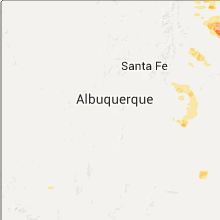
New Mexico
| Local Time | Report Details |
|---|---|
| 2:27 PM MDT | Half Dollar sized hail reported near Raton, NM, 71.1 miles ENE of Taos, NM, half dollar size hail reported with quarter size hail continuing to fall. |
| 3:40 PM MDT | Half Dollar sized hail reported near Raton, NM, 71.6 miles ENE of Taos, NM, there was 0.71 of rain at report and raining again. hail ranging from pea size to half dollar size... most are nickel to quarter size. |
| 6:30 PM MDT | Quarter sized hail reported near Wagon Mound, NM, 56 miles ESE of Taos, NM, pea to quarter size hail accumulated 2 to 3 inches deep. |
Arkansas
| Local Time | Report Details |
|---|---|
| 4:00 PM CDT | Large tree branch laying on hwy 63 at lawrence co line from craighead c in lawrence county AR, 73.2 miles NW of Memphis, TN |
| 4:05 PM CDT | A few trees down and a pool damage in lawrence county AR, 73.2 miles NW of Memphis, TN |
Colorado
| Local Time | Report Details |
|---|---|
| 3:48 PM MDT | Tennis Ball sized hail reported near Monument, CO, 45.6 miles S of Denver, CO, . |
| 3:55 PM MDT | Quarter sized hail reported near Colorado Springs, CO, 50.5 miles S of Denver, CO, . |
| 4:05 PM MDT | Golf Ball sized hail reported near Colorado Springs, CO, 47.8 miles N of Pueblo, CO, . |
| 4:14 PM MDT | Half Dollar sized hail reported near Colorado Springs, CO, 48.4 miles N of Pueblo, CO, . |
| 4:18 PM MDT | Quarter sized hail reported near U S A F Academy, CO, 50.1 miles S of Denver, CO, . |
| 4:20 PM MDT | Half Dollar sized hail reported near Colorado Springs, CO, 48.4 miles N of Pueblo, CO, . |
| 4:25 PM MDT | Half Dollar sized hail reported near Colorado Springs, CO, 51.1 miles N of Pueblo, CO, . |
| 4:30 PM MDT | Quarter sized hail reported near Peyton, CO, 48.7 miles N of Pueblo, CO, . the duration of the hail event was 10 minutes. |
| 4:45 PM MDT | Quarter sized hail reported near Fountain, CO, 30.4 miles N of Pueblo, CO, . |
| 5:27 PM MDT | Quarter sized hail reported near Colorado City, CO, 25.7 miles SSW of Pueblo, CO, . |
| 5:32 PM MDT | Quarter sized hail reported near Colorado City, CO, 25.7 miles SSW of Pueblo, CO, . |
| 5:38 PM MDT | Quarter sized hail reported near Rye, CO, 26.5 miles SSW of Pueblo, CO, . the reported observer location was 3 se colo city. |
Wyoming
| Local Time | Report Details |
|---|---|
| 3:55 PM MDT | Storm damage reported in laramie county WY, 43.1 miles ESE of Laramie, WY |
Texas
| Local Time | Report Details |
|---|---|
| 5:05 PM CDT | West texas mesonet report in cottle county TX, 38.7 miles SSW of Childress, TX |
| 5:15 PM CDT | West texas mesonet report in cottle county TX, 38.7 miles SSW of Childress, TX |
| 5:34 PM CDT | Power poles down from wind gusts in cottle county TX, 28.3 miles SSW of Childress, TX |
| 5:51 PM CDT | Quarter sized hail reported near , , 47.1 miles S of Childress, TX |
| 6:11 PM CDT | Power poles down from wind gusts in cottle county TX, 28.3 miles SSW of Childress, TX |
| 7:01 PM CDT | The tarzan mesonet recorded a 58 mph gus in martin county TX, 38.9 miles NNE of Odessa, TX |
| 7:50 PM CDT | Golf Ball sized hail reported near Midland, TX, 19.9 miles ENE of Odessa, TX, quarter to golf ball sized hail on the south side of midland. |
| 7:55 PM CDT | Quarter sized hail reported near Midland, TX, 21.2 miles ENE of Odessa, TX |
| 8:00 PM CDT | Roof blown off garage... damage to home at powell and frankli in midland county TX, 20.2 miles ENE of Odessa, TX |
| 8:02 PM CDT | Power lines down on wall street in midland in midland county TX, 20.2 miles ENE of Odessa, TX |
North Carolina
| Local Time | Report Details |
|---|---|
| 6:06 PM EDT | Quarter sized hail reported near Black Mountain, NC, 55.5 miles NNE of Greenville, SC, also estimated 55 mph wind gust |
| 6:10 PM EDT | Half Dollar sized hail reported near Black Mountain, NC, 55.8 miles NNE of Greenville, SC |
| 6:12 PM EDT | Golf Ball sized hail reported near Black Mountain, NC, 56.8 miles NNE of Greenville, SC, reported at exit 65 on i-40. |
| 6:18 PM EDT | Quarter sized hail reported near Old Fort, NC, 57.9 miles NNE of Greenville, SC |
| 6:20 PM EDT | Trees down. bat cave road close in mcdowell county NC, 56 miles NNE of Greenville, SC |
| 6:28 PM EDT | Four to six trees blown down across rockingham county...most likely near the eden are in rockingham county NC, 53.7 miles SSE of Roanoke, VA |
| 6:30 PM EDT | Tree down at the intersection of poure road and route 704 in stokes county NC, 53.2 miles SSW of Roanoke, VA |
| 6:38 PM EDT | Around thirty to fourty trees down in reese and zionville and in other areas of western watauga county...entered reese at 638 pm and crossed zionville at 643 pm in watauga county NC, 28.7 miles SE of Bristol, TN |
| 6:43 PM EDT | One tree down on lawrence roa in caswell county NC, 61.6 miles SE of Roanoke, VA |
| 6:45 PM EDT | One tree down on melvin wrenn roa in caswell county NC, 60.9 miles NW of Raleigh, NC |
| 6:45 PM EDT | One tree down near intersection of blanch road and culver roa in caswell county NC, 61 miles NW of Raleigh, NC |
| 6:45 PM EDT | *** 3 inj *** extensive damage reported across the entire county between about 630 and 700 pm. several injuries have been reported but exact numbers are not availabl in watauga county NC, 40.5 miles SE of Bristol, TN |
| 6:45 PM EDT | Multiple trees down along route 194 near meat camp road in watauga county NC, 38.4 miles SE of Bristol, TN |
| 6:48 PM EDT | Multiple trees down along bamboo road and deerfield road in watauga county NC, 43.9 miles SE of Bristol, TN |
| 6:50 PM EDT | One tree down on quick roa in caswell county NC, 62.7 miles SSE of Roanoke, VA |
| 6:53 PM EDT | A couple of power lines blown down near pine hall and between pine hall and walnut cov in stokes county NC, 66 miles S of Roanoke, VA |
| 6:53 PM EDT | One tree down on old satterfield roa in caswell county NC, 60.2 miles NW of Raleigh, NC |
| 6:55 PM EDT | Nunerous trees and power lines down. wind gusts estimated at 60 mph or greater by trained spotte in watauga county NC, 40.5 miles SE of Bristol, TN |
| 6:55 PM EDT | Tree down along curtis creek rd in avery county NC, 33.7 miles SSE of Bristol, TN |
| 6:55 PM EDT | Measured wind gust of 63 mph at ktnb located in boone north carolina in watauga county NC, 41.8 miles SE of Bristol, TN |
| 6:55 PM EDT | Tree down on river road near pine hall in stokes county NC, 65.8 miles S of Roanoke, VA |
| 6:56 PM EDT | Two trees blown dow in nash county NC, 45.1 miles ENE of Raleigh, NC |
| 7:00 PM EDT | One tree down on stephentown roa in caswell county NC, 54.9 miles NW of Raleigh, NC |
| 7:00 PM EDT | One power line down on route 86 near the northern city limits of yanceyville in caswell county NC, 60.4 miles NW of Raleigh, NC |
| 7:00 PM EDT | Storm damage reported in avery county NC, 39.7 miles SSE of Bristol, TN |
| 7:03 PM EDT | Tree down at 4670 hickory nut gap roa in avery county NC, 35.6 miles SSE of Bristol, TN |
| 7:05 PM EDT | Trees down on little mountain creek rd and hwy 96/sunset r in granville county NC, 40.3 miles N of Raleigh, NC |
| 7:09 PM EDT | Multiple power lines and trees down in millers creek in wilkes county NC, 61.3 miles ESE of Bristol, TN |
| 7:10 PM EDT | Tree blocking both lanes of hwy 321 in caldwell county SC, 55.5 miles SE of Bristol, TN |
| 7:12 PM EDT | Several tree limbs down and dime sized hail fell in wilkes county NC, 62.3 miles ESE of Bristol, TN |
| 7:14 PM EDT | Several trees and powerlines down on a farm near ferguson and a roof blown off a building in wilkes county NC, 58.8 miles SE of Bristol, TN |
| 7:15 PM EDT | Several one foot in diameter pine trees blown down on green meadow lane in wilkes county NC, 63.3 miles ESE of Bristol, TN |
| 7:15 PM EDT | Several trees down of at least 6 inches in diamete in wilkes county NC, 57.9 miles ESE of Bristol, TN |
| 7:16 PM EDT | Several tree tops snapped by thunderstorm wind in wilkes county NC, 62.6 miles ESE of Bristol, TN |
| 7:17 PM EDT | Turtle dove rd in caldwell county NC, 60.7 miles SE of Bristol, TN |
| 7:17 PM EDT | Turtle dove rd in caldwell county NC, 60.7 miles SE of Bristol, TN |
| 7:20 PM EDT | Multiple trees down near mobile home park along calico rd and hartland r in caldwell county NC, 60.7 miles SE of Bristol, TN |
| 7:20 PM EDT | Trees dow in yancey county NC, 46.5 miles S of Bristol, TN |
| 7:24 PM EDT | Scanner reports relayed via social media of at least 20 reports of trees and powerlines down. at least one on a residence with entrapment. roof damage to a gas statio in iredell county NC, 55 miles N of Charlotte, NC |
| 7:25 PM EDT | Many trees and powerlines down along hartland rd and highway 1 in caldwell county NC, 60.7 miles SE of Bristol, TN |
| 7:25 PM EDT | Thunderstorm winds downed several large 100+ year old oak trees... a few pines... and several softer trees and large limbs near hays n in wilkes county NC, 65.7 miles ESE of Bristol, TN |
| 7:34 PM EDT | Multiple trees down along piney grove rd and sulphur springs rd in alexander county NC, 51.8 miles NNW of Charlotte, NC |
| 7:37 PM EDT | Tree down at bethel church rd and durango dr. several other trees reported down across the count in forsyth county NC, 76.9 miles S of Roanoke, VA |
| 7:37 PM EDT | One tree down near the state road grocery store in wilkes county NC, 76.7 miles ESE of Bristol, TN |
| 7:38 PM EDT | Tree on home with possible structual collapse on lakeside loop in alexander county NC, 47.9 miles NNW of Charlotte, NC |
| 7:40 PM EDT | Large tree across roadway on cheatham ford r in alexander county NC, 48.8 miles NNW of Charlotte, NC |
| 7:40 PM EDT | Sulphur spings road closed in vashti due to trees in alexander county NC, 55.2 miles NNW of Charlotte, NC |
| 7:41 PM EDT | Many trees and powerlines down at intersection of hartland rd and highway 18 in caldwell county NC, 60.7 miles SE of Bristol, TN |
| 7:44 PM EDT | Scattered trees down countywide in swain county NC, 45.2 miles SE of Knoxville, TN |
| 7:45 PM EDT | Quarter sized hail reported near Lawndale, NC, 42.3 miles WNW of Charlotte, NC |
| 7:45 PM EDT | Warren county 911 reports at least 10 trees down across the count in warren county NC, 50.2 miles NNE of Raleigh, NC |
| 7:45 PM EDT | Multiple trees down at intersection of falston rd and clineland r in cleveland county NC, 36.5 miles WNW of Charlotte, NC |
| 7:49 PM EDT | Numerous large trees blown down by thunderstorm winds on angus road near boonevill in yadkin county NC, 67.8 miles N of Charlotte, NC |
| 7:50 PM EDT | Several trees dow in gaston county NC, 32.5 miles WNW of Charlotte, NC |
| 7:55 PM EDT | Quarter sized hail reported near Sylva, NC, 51.1 miles NW of Greenville, SC |
| 7:55 PM EDT | Trees down across the western sections of the hiawasse dam/villag in cherokee county NC, 57.6 miles SSW of Knoxville, TN |
| 7:57 PM EDT | 3 large trees down along robert r in gaston county NC, 31.4 miles WNW of Charlotte, NC |
| 7:57 PM EDT | Tree down at brassfield rd and robert procher wa in guilford county NC, 72.3 miles WNW of Raleigh, NC |
| 8:00 PM EDT | Golf Ball sized hail reported near Stanley, NC, 18.8 miles NW of Charlotte, NC |
| 8:05 PM EDT | Ping Pong Ball sized hail reported near Stanley, NC, 17.6 miles WNW of Charlotte, NC |
| 8:10 PM EDT | Siding blown off a hous in lincoln county NC, 23.6 miles NW of Charlotte, NC |
| 8:20 PM EDT | Several trees reported down in east gastonia in gaston county NC, 18.9 miles W of Charlotte, NC |
| 8:20 PM EDT | Several trees blown down in the area of middlebrook dr and idols r in forsyth county NC, 59.5 miles NNE of Charlotte, NC |
| 8:25 PM EDT | 911 center and public report of trees and power lines down in robersonville and possible structure damage. time estimated based on rada in martin county NC, 78.3 miles E of Raleigh, NC |
| 8:25 PM EDT | Edgecombe county 911 reports numerous trees down across the count in edgecombe county NC, 61.4 miles E of Raleigh, NC |
| 8:26 PM EDT | Scattered trees down along highway 276 south of brevar in transylvania county NC, 22.5 miles NNW of Greenville, SC |
| 8:30 PM EDT | Several trees down south part of county and east of murphy in cherokee county NC, 60.3 miles S of Knoxville, TN |
| 8:30 PM EDT | Quarter sized hail reported near Mount Holly, NC, 14.6 miles NW of Charlotte, NC |
| 8:32 PM EDT | Scanner relay of several trees dow in iredell county NC, 24.7 miles N of Charlotte, NC |
| 8:35 PM EDT | Tree down on i-85 near mile marker 93. in addition... davidson 911 reports numerous other trees down across the count in davidson county NC, 52 miles NE of Charlotte, NC |
| 8:38 PM EDT | Scattered trees and utility lines down across northwest charlott in mecklenburg county NC, 6.1 miles WNW of Charlotte, NC |
| 8:40 PM EDT | Trees down including one on a hous in mecklenburg county NC, 2.9 miles ENE of Charlotte, NC |
| 8:42 PM EDT | 2 large trees down on a house in plaza midwoo in mecklenburg county NC, 2.2 miles ENE of Charlotte, NC |
| 8:45 PM EDT | Trees down all across the southern end of rowan count in rowan county NC, 33 miles NE of Charlotte, NC |
| 8:45 PM EDT | City em reported 15 trees down in the city... one on a house. numerous power outages from concord to mount pleasan in cabarrus county NC, 19 miles NE of Charlotte, NC |
| 8:50 PM EDT | Johnston county 911 reports several trees down in the road along and near hwy 42 east of clayto in johnston county NC, 20.6 miles ESE of Raleigh, NC |
| 8:50 PM EDT | Tree down at s bbunker hill rd and hawkins t in guilford county NC, 75.5 miles NE of Charlotte, NC |
| 8:53 PM EDT | Trees and power lines dow in orange county NC, 32.7 miles NW of Raleigh, NC |
| 8:55 PM EDT | Trees down on powerlines on burlwood and lower rocky river roa in cabarrus county NC, 14.7 miles ENE of Charlotte, NC |
| 9:00 PM EDT | Trees down on miller mountai in polk county NC, 34.7 miles NNE of Greenville, SC |
| 9:00 PM EDT | Randolph county em reports at least 12-15 reports of downed trees across the count in randolph county NC, 57 miles ENE of Charlotte, NC |
| 9:05 PM EDT | Quarter sized hail reported near Goldsboro, NC, 44.1 miles SE of Raleigh, NC, hail of at least quarter sized observed on i-795. |
| 9:11 PM EDT | Officers reported several trees down in the fremont are in wayne county NC, 40.9 miles ESE of Raleigh, NC |
| 9:15 PM EDT | Numerous reports of trees down across the county between 900 and 930 pm ed in greene county NC, 56.2 miles ESE of Raleigh, NC |
| 9:15 PM EDT | Scattered areas of downed trees across the county... some on power line in union county NC, 23.3 miles SE of Charlotte, NC |
| 9:20 PM EDT | Trees dow in pitt county NC, 66.7 miles E of Raleigh, NC |
| 9:25 PM EDT | Tree down on juniper c in orange county NC, 25.8 miles WNW of Raleigh, NC |
| 9:35 PM EDT | Structure damage on river road. time estimated based on rada in craven county NC, 82.1 miles NNE of Wilmington, NC |
| 9:40 PM EDT | Anson county 911 reports several trees down in the lilesville are in anson county NC, 51.1 miles ESE of Charlotte, NC |
| 9:47 PM EDT | Two trees down blocking both lanes of traffic... bascom chapel rd and dan r in moore county NC, 62.8 miles WSW of Raleigh, NC |
| 9:50 PM EDT | Tree down reported on pinehurst s in moore county NC, 63.8 miles SW of Raleigh, NC |
| 9:50 PM EDT | Barn blown into road in 2100 block of county line r in johnston county NC, 23.2 miles S of Raleigh, NC |
| 9:52 PM EDT | Mping report of large branches and power poles downed in cleveland county NC, 50.6 miles W of Charlotte, NC |
| 9:55 PM EDT | Tree reported down on lake forest dr... blocking both lane in moore county NC, 63.4 miles SW of Raleigh, NC |
| 9:55 PM EDT | Kewn asos gust to 58 mp in craven county NC, 78.4 miles NE of Wilmington, NC |
| 9:56 PM EDT | Awos station 2 wnw camp mackall /hff in richmond county NC, 71.1 miles SW of Raleigh, NC |
| 10:15 PM EDT | Trees down on highway 70 near catfish lake roa in craven county NC, 73 miles NE of Wilmington, NC |
| 10:20 PM EDT | Trees and fence knocked dow in craven county NC, 73.5 miles NE of Wilmington, NC |
| 10:20 PM EDT | Trees down on highway 24 at midway par in onslow county NC, 49.9 miles NE of Wilmington, NC |
| 10:27 PM EDT | Alligator river in amz130 county NC, 59 miles S of Virginia Beach, VA |
| 10:27 PM EDT | Trees in the road near the intersection of raynor and beasley road in johnston county NC, 32.4 miles SSE of Raleigh, NC |
| 12:02 AM EDT | Tree fell on home in kelly... on pinewood road off of lightknot road in bladen county NC, 26 miles NW of Wilmington, NC |
Georgia
| Local Time | Report Details |
|---|---|
| 8:20 PM EDT | A tree was blown down at ivylog rd and moccasin r in union county GA, 69.4 miles S of Knoxville, TN |
| 8:20 PM EDT | A tree was blown down on ivylog creek roa in union county GA, 69.2 miles S of Knoxville, TN |
| 8:35 PM EDT | Large tree limbs were blown down in front of home depot on highway 51 in union county GA, 74.5 miles S of Knoxville, TN |
| 8:45 PM EDT | A tree was blown down on caldwell rd near murphy highwa in union county GA, 72.6 miles S of Knoxville, TN |
| 11:39 PM EDT | Reported tree down on a power line in thomson. in mcduffie county GA, 30.3 miles W of Augusta, GA |
| 11:57 PM EDT | Tree down on home just off of mike padgett highwa in richmond county GA, 8.2 miles S of Augusta, GA |
New York
| Local Time | Report Details |
|---|---|
| 11:15 PM EDT | Awnings torn off of camper in chautauqua county NY, 59.8 miles S of Buffalo, NY |
Connect with Interactive Hail Maps