

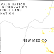
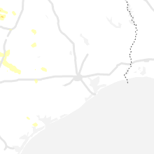
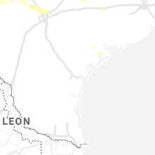
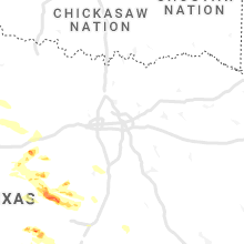
Hail Map for Friday, May 28, 2021

Number of Impacted Households on 5/28/2021
0
Impacted by 1" or Larger Hail
0
Impacted by 1.75" or Larger Hail
0
Impacted by 2.5" or Larger Hail
Square Miles of Populated Area Impacted on 5/28/2021
0
Impacted by 1" or Larger Hail
0
Impacted by 1.75" or Larger Hail
0
Impacted by 2.5" or Larger Hail


Cities Most Affected by Hail Storms of 5/28/2021
| Hail Size | Demographics of Zip Codes Affected | ||||||
|---|---|---|---|---|---|---|---|
| City | Count | Average | Largest | Pop Density | House Value | Income | Age |
| Dexter, NM | 3 | 2.90 | 3.00 | 13 | $45k | $29.6k | 34.6 |
| Crane, TX | 2 | 2.00 | 2.00 | 12 | $38k | $31.4k | 35.1 |
| Coyanosa, TX | 1 | 2.50 | 2.50 | 0 | $27k | $22.9k | 42.9 |
| Mentone, TX | 1 | 2.00 | 2.00 | 0 | $13k | $40.0k | 53.0 |
| Odessa, TX | 1 | 2.00 | 2.00 | 26 | $55k | $32.4k | 30.3 |
| Capitan, NM | 1 | 2.00 | 2.00 | 0 | $87k | $28.1k | 49.3 |
| Carlsbad, NM | 1 | 2.00 | 2.00 | 16 | $65k | $32.8k | 38.4 |
| Artesia, NM | 1 | 1.75 | 1.75 | 13 | $65k | $31.3k | 35.1 |
| Mertzon, TX | 1 | 1.75 | 1.75 | 0 | $61k | $38.1k | 44.9 |
| Portales, NM | 1 | 1.75 | 1.75 | 28 | $55k | $26.6k | 29.0 |
| Broadus, MT | 1 | 1.75 | 1.75 | 0 | $58k | $27.8k | 49.9 |
| Llano, TX | 1 | 1.75 | 1.75 | 10 | $85k | $35.8k | 51.0 |
Hail and Wind Damage Spotted on 5/28/2021
Filter by Report Type:Hail ReportsWind Reports
States Impacted
Texas, Tennessee, Virginia, New Mexico, Montana, Maryland, Wyoming, South Carolina, ColoradoTexas
| Local Time | Report Details |
|---|---|
| 7:25 AM CDT | Quarter sized hail reported near Flomot, TX, 43.1 miles WSW of Childress, TX |
| 12:45 PM CDT | Quarter sized hail reported near Shallowater, TX, 10.2 miles NW of Lubbock, TX, several reports of nickel to quarter-sized hail. |
| 1:01 PM CDT | Quarter sized hail reported near Lubbock, TX, 8.3 miles NW of Lubbock, TX, report via twitter. |
| 1:14 PM CDT | Quarter sized hail reported near Ralls, TX, 28.1 miles ENE of Lubbock, TX, report via twitter |
| 1:22 PM CDT | Half Dollar sized hail reported near Ralls, TX, 26.8 miles ENE of Lubbock, TX, mostly quarters... with some 1.25" hail stones. |
| 2:30 PM CDT | Quarter sized hail reported near Gatesville, TX, 24.3 miles NNW of Killeen, TX, broadcast media reported quarter size hail in arnett. |
| 3:07 PM CDT | 5 small aircraft overturned at the gatesville airport with significant damage to at least 1 aircraft hanger. a handful of trees down across the city of gatesvill in coryell county TX, 21.3 miles NNW of Killeen, TX |
| 4:46 PM CDT | Quarter sized hail reported near Alpine, TX, 0.3 miles WNW of Alpine, TX, social media report of pea sized hail with quarter size hail mixed in. |
| 5:05 PM CDT | Golf Ball sized hail reported near Llano, TX, 49.2 miles WSW of Killeen, TX, golf ball sized hail reported between tow and bluffton... relayed via ham. location marker is approximate. |
| 5:23 PM CDT | Tennis Ball sized hail reported near Coyanosa, TX, 63.3 miles SW of Odessa, TX, spotter photo of 2.5 inch hailstone. |
| 5:48 PM CDT | Half Dollar sized hail reported near Mertzon, TX, 98.9 miles SW of Abilene, TX |
| 5:50 PM CDT | Quarter sized hail reported near Mertzon, TX, 100.8 miles ESE of Odessa, TX |
| 5:52 PM CDT | Quarter sized hail reported near Mertzon, TX, 100.6 miles ESE of Odessa, TX |
| 5:52 PM CDT | Golf Ball sized hail reported near Mertzon, TX, 100 miles ESE of Odessa, TX, observed golf ball size hail. no damage or injuries. |
| 6:00 PM CDT | Delayed report of trees down on 2147 outside of cottonwood shores. time approximat in burnet county TX, 52.2 miles SW of Killeen, TX |
| 6:09 PM CDT | Hen Egg sized hail reported near Crane, TX, 37.6 miles SSW of Odessa, TX |
| 6:10 PM CDT | Quarter sized hail reported near Grandfalls, TX, 46.4 miles SW of Odessa, TX |
| 6:20 PM CDT | Hen Egg sized hail reported near Mentone, TX, 80.1 miles W of Odessa, TX, social media photo of hen egg size hail along 652 one mile south of the state line. |
| 6:34 PM CDT | 64 mph wind gust measured at a personal weather station near thurman bend r in travis county TX, 51.7 miles SSW of Killeen, TX |
| 6:35 PM CDT | Cwop station reported 58 mph wind gust. fm 2769 at hill s in travis county TX, 48.4 miles SSW of Killeen, TX |
| 6:35 PM CDT | Quarter sized hail reported near Junction, TX, 101 miles NE of Del Rio, TX |
| 6:38 PM CDT | Cwop mesonet station near villa montana way reported 67 mph wind gus in travis county TX, 49.4 miles S of Killeen, TX |
| 6:42 PM CDT | Hen Egg sized hail reported near Crane, TX, 31.8 miles S of Odessa, TX, 65 mph wind gust measured |
| 6:42 PM CDT | Tea Cup sized hail reported near , , 21.9 miles SW of Odessa, TX, 61 mph measured wind gust as well. |
| 6:59 PM CDT | Quarter sized hail reported near Saragosa, TX, 46.3 miles N of Alpine, TX |
| 7:08 PM CDT | Golf Ball sized hail reported near , , 69.7 miles W of Odessa, TX |
| 7:09 PM CDT | West texas mesonet site at segovia 7 ssw measured a wind gust of 65 mp in kimble county TX, 96 miles NW of San Antonio, TX |
| 7:11 PM CDT | Asos station kaus austin-bergstrom intl arp in travis county TX, 64.6 miles S of Killeen, TX |
| 7:14 PM CDT | Corrects previous non-tstm wnd gst report from 6 s wells branch. estimated 60 mph gusts at rundberg and i-35... about an inch of water on i-35 reported as well with tor in travis county TX, 52.2 miles S of Killeen, TX |
| 7:15 PM CDT | Quarter sized hail reported near Johnson City, TX, 61.7 miles N of San Antonio, TX, cocorahs observer reported nickel and quarter sized hail. |
| 7:20 PM CDT | Hen Egg sized hail reported near Odessa, TX, 11.7 miles S of Odessa, TX, 60 mph wind also reported. |
| 7:21 PM CDT | Hen Egg sized hail reported near , , 15.2 miles S of Odessa, TX, 2.2 inch measured |
| 7:35 PM CDT | Report of the roof torn off at the red rock general stor in bastrop county TX, 72.8 miles ENE of San Antonio, TX |
| 7:51 PM CDT | Quarter sized hail reported near Kerrville, TX, 58 miles NW of San Antonio, TX |
| 7:56 PM CDT | Tennis Ball sized hail reported near , , 60.5 miles WSW of Odessa, TX |
| 8:00 PM CDT | Quarter sized hail reported near Mentone, TX, 72.7 miles W of Odessa, TX |
| 8:08 PM CDT | Powerline down on hwy 38 in ector county TX, 9.8 miles SSE of Odessa, TX |
| 8:20 PM CDT | Hen Egg sized hail reported near , , 58.6 miles WSW of Odessa, TX, relayed report of 2 inch hail along i-20 8e barstow. |
| 8:27 PM CDT | Large tree blown down over southbound lanes of u.s. 7 in fayette county TX, 91.6 miles W of Houston, TX |
| 8:36 PM CDT | Measured by davis instrumen in fayette county TX, 92.1 miles W of Houston, TX |
| 9:11 PM CDT | Large tree limbs and power poles broke in bexar county TX, 22 miles NNW of San Antonio, TX |
| 9:20 PM CDT | Storm damage reported in yoakum county TX, 62.1 miles WSW of Lubbock, TX |
| 9:28 PM CDT | Power line down at mexico road and north 38 in hockley county TX, 29.1 miles WNW of Lubbock, TX |
| 9:32 PM CDT | Measured by sat aso in bexar county TX, 8 miles N of San Antonio, TX |
| 9:33 PM CDT | 77 mph gust recorded at sat aso in bexar county TX, 8 miles N of San Antonio, TX |
| 9:35 PM CDT | Small tree limbs broke in bexar county TX, 3.1 miles N of San Antonio, TX |
| 9:35 PM CDT | Numerous reported of tree... fence... and power line damage across the north and northeast side of the san antonio metro are in bexar county TX, 10.5 miles NE of San Antonio, TX |
| 9:39 PM CDT | Large tree trunk snappe in bexar county TX, 9.5 miles NE of San Antonio, TX |
| 10:32 PM CDT | Andrews mesonet in andrews county TX, 33.4 miles NNW of Odessa, TX |
| 10:55 PM CDT | Quarter sized hail reported near Andrews, TX, 34 miles NNW of Odessa, TX |
| 11:40 PM CDT | Small tree limbs down and estimated winds of 60 mp in ector county TX, 6.8 miles W of Odessa, TX |
| 11:55 PM CDT | Storm damage reported in howard county TX, 47.3 miles ENE of Odessa, TX |
| 1:07 AM CDT | Storm damage reported in reagan county TX, 69.7 miles SE of Odessa, TX |
| 3:30 AM CDT | Quarter sized hail reported near Comstock, TX, 23.8 miles NW of Del Rio, TX, quarter sized hail reported by border patrol near comstock. |
Tennessee
| Local Time | Report Details |
|---|---|
| 1:03 PM CDT | Trees down on watauga drive in east cookevill in putnam county TN, 72 miles E of Nashville, TN |
| 4:11 PM EDT | Trees down in the area... and some power outage in anderson county TN, 17.8 miles NW of Knoxville, TN |
| 5:06 PM EDT | Report from mping: 3-inch tree limbs broken in hamblen county TN, 31.2 miles ENE of Knoxville, TN |
| 5:09 PM EDT | Sustained winds around 40mph with strongest gusts up to around 60mp in hamblen county TN, 32.5 miles ENE of Knoxville, TN |
| 5:10 PM EDT | Trees down and limbs broken in panther creek state par in hamblen county TN, 33.4 miles ENE of Knoxville, TN |
| 5:10 PM EDT | Spotter measured 67mph gust. numerous large tree limbs dow in hamblen county TN, 35.5 miles ENE of Knoxville, TN |
| 5:10 PM EDT | Damage to several boats at cedar hill marina on cherokee lak in hamblen county TN, 32.1 miles ENE of Knoxville, TN |
| 5:11 PM EDT | Shed damage in hamblen county TN, 36.8 miles ENE of Knoxville, TN |
| 6:50 PM EDT | Reports of trees down around hampto in carter county TN, 21 miles S of Bristol, TN |
Virginia
| Local Time | Report Details |
|---|---|
| 2:12 PM EDT | Trees dow in westmoreland county VA, 71.5 miles ENE of Richmond, VA |
| 2:56 PM EDT | Trees and power lines down in lancaster shore in lancaster county VA, 61.4 miles ENE of Richmond, VA |
| 3:00 PM EDT | Numerous trees and power lines down on shore drive and sycamore ln off of morattico r in lancaster county VA, 61.9 miles ENE of Richmond, VA |
| 3:25 PM EDT | Corrects previous time of tstm wnd dmg report from lottsburg. tree downed along northumberland highway (us-360) between callao and lottsbur in northumberland county VA, 69.8 miles ENE of Richmond, VA |
| 3:35 PM EDT | Tree downed along northumberland highway (us-360) between callao and lottsbur in northumberland county VA, 69.8 miles ENE of Richmond, VA |
| 4:09 PM EDT | One tree down near intersection of red house and country estates roa in appomattox county VA, 61.3 miles E of Roanoke, VA |
| 4:20 PM EDT | Tree down on us highway 220 blocking one lane near the exit ramp to rocky mount. time estimated from rada in franklin county VA, 17 miles SSE of Roanoke, VA |
| 5:37 PM EDT | Two trees blew down on massaponax church road near hickory ridge roa in spotsylvania county VA, 47.6 miles N of Richmond, VA |
| 5:47 PM EDT | Tree blew down on route 607 near kings highwa in king george county VA, 56.6 miles NNE of Richmond, VA |
| 6:29 PM EDT | Tree blew down on hungerford road near bryans roa in king george county VA, 58.8 miles NNE of Richmond, VA |
| 7:21 PM EDT | Tree down near ashdale r in essex county VA, 53 miles ENE of Richmond, VA |
| 9:03 PM EDT | Tree dow in southampton county VA, 57.9 miles SSE of Richmond, VA |
| 1:49 AM EDT | 1-inch tree limbs broken; shingles blown of in pittsylvania county VA, 48.6 miles SE of Roanoke, VA |
New Mexico
| Local Time | Report Details |
|---|---|
| 1:36 PM MDT | Quarter sized hail reported near Ilfeld, NM, 66.6 miles ENE of Albuquerque, NM |
| 2:30 PM MDT | Quarter sized hail reported near Des Moines, NM, 91 miles ENE of Taos, NM |
| 3:15 PM MDT | Ping Pong Ball sized hail reported near Des Moines, NM, 91 miles ENE of Taos, NM |
| 3:42 PM MDT | Quarter sized hail reported near Encino, NM, 78.5 miles E of Albuquerque, NM |
| 4:12 PM MDT | Ping Pong Ball sized hail reported near Corona, NM, 66.3 miles NW of Roswell, NM |
| 4:15 PM MDT | Quarter sized hail reported near Tucumcari, NM, 13.9 miles WSW of Tucumcari, NM, along i-40 |
| 5:00 PM MDT | Quarter sized hail reported near Tucumcari, NM, 15.9 miles S of Tucumcari, NM, on highway 209 |
| 5:20 PM MDT | Storm damage reported in de baca county NM, 55.2 miles SSW of Tucumcari, NM |
| 6:05 PM MDT | Hen Egg sized hail reported near Capitan, NM, 41.9 miles WNW of Roswell, NM |
| 6:25 PM MDT | Quarter sized hail reported near Roswell, NM, 7.5 miles WSW of Roswell, NM, partially covered highway 380. |
| 6:40 PM MDT | Quarter sized hail reported near Dexter, NM, 10.1 miles SSE of Roswell, NM |
| 6:40 PM MDT | Quarter sized hail reported near Roswell, NM, 5.3 miles SSE of Roswell, NM, krow asos. |
| 6:41 PM MDT | Quarter sized hail reported near Portales, NM, 72.2 miles SSE of Tucumcari, NM |
| 6:45 PM MDT | Quarter sized hail reported near Portales, NM, 73.1 miles SSE of Tucumcari, NM |
| 6:45 PM MDT | Quarter sized hail reported near Portales, NM, 72.2 miles SSE of Tucumcari, NM |
| 6:47 PM MDT | Golf Ball sized hail reported near Portales, NM, 72.2 miles SSE of Tucumcari, NM |
| 6:48 PM MDT | Tennis Ball sized hail reported near Dexter, NM, 13.2 miles SSE of Roswell, NM |
| 6:50 PM MDT | Power pole bending toward road in chaves county NM, 14.9 miles SSE of Roswell, NM |
| 6:50 PM MDT | Half Dollar sized hail reported near Portales, NM, 72.9 miles SSE of Tucumcari, NM, torrential rain 65-70 mph wind gusts |
| 6:52 PM MDT | Quarter sized hail reported near Clovis, NM, 61.2 miles SSE of Tucumcari, NM |
| 6:57 PM MDT | Tea Cup sized hail reported near Dexter, NM, 13.4 miles SSE of Roswell, NM, on highway 285 |
| 6:57 PM MDT | Tea Cup sized hail reported near Dexter, NM, 11.3 miles SSE of Roswell, NM, on highway 285 |
| 7:00 PM MDT | Power poles and lines down in parts of clovi in curry county NM, 62.6 miles SSE of Tucumcari, NM |
| 7:08 PM MDT | Kcvn awo in curry county NM, 63.6 miles SE of Tucumcari, NM |
| 7:08 PM MDT | Quarter sized hail reported near Dexter, NM, 16.7 miles SSE of Roswell, NM, at lake van |
| 7:12 PM MDT | Snapped power pole on morgan rd. 1mi w of sr2 near hagerman in chaves county NM, 21.8 miles SSE of Roswell, NM |
| 7:30 PM MDT | Tatum mesonet measures 66 mph wind gus in lea county NM, 69.4 miles E of Roswell, NM |
| 7:31 PM MDT | Storm damage reported in lea county NM, 69.7 miles E of Roswell, NM |
| 8:19 PM MDT | Ping Pong Ball sized hail reported near Artesia, NM, 38.7 miles SSE of Roswell, NM, social media report of mostly quarter size hail or smaller with a few ping pong ball size hail. |
| 8:45 PM MDT | Quarter sized hail reported near Artesia, NM, 54.3 miles S of Roswell, NM, report of mostly smaller hail around dime size with largest hail up to quarter size. |
| 9:01 PM MDT | Golf Ball sized hail reported near Artesia, NM, 55.1 miles S of Roswell, NM, spotter report of up to golf ball size hail on the road at their location. hailed for about 10 minutes. |
| 9:13 PM MDT | Quarter sized hail reported near Carlsbad, NM, 70.5 miles SSE of Roswell, NM, social media photo of quarter size hail in carlsbad. |
| 9:14 PM MDT | Hen Egg sized hail reported near Carlsbad, NM, 62.4 miles S of Roswell, NM, spotter reports quarter size hail falling with hen egg size hail on the highway. |
Montana
| Local Time | Report Details |
|---|---|
| 4:08 PM MDT | Half Dollar sized hail reported near Edgar, MT, 27.4 miles SW of Billings, MT, half dollar hail with 4 inch/hour rainfall. |
| 4:10 PM MDT | Ping Pong Ball sized hail reported near Fromberg, MT, 27.9 miles SW of Billings, MT, hail size ranging from pea to ping pong ball. |
| 5:23 PM MDT | Quarter sized hail reported near Fort Smith, MT, 43.4 miles SE of Billings, MT, leaf damage shredded leaves car dents broken car windows. |
| 5:25 PM MDT | Half Dollar sized hail reported near Fort Smith, MT, 43 miles SE of Billings, MT, hail was half dollar sized and smaller. |
| 6:13 PM MDT | Wolf mountain raws in big horn county MT, 72.6 miles ESE of Billings, MT |
| 6:18 PM MDT | Storm damage reported in big horn county MT, 72.6 miles ESE of Billings, MT |
| 7:48 PM MDT | Golf Ball sized hail reported near Broadus, MT, 68.2 miles SSE of Miles City, MT |
| 7:50 PM MDT | Quarter sized hail reported near Broadus, MT, 70 miles SSE of Miles City, MT |
| 8:36 PM MDT | Storm damage reported in powder river county MT, 49.9 miles N of Gillette, WY |
Maryland
| Local Time | Report Details |
|---|---|
| 6:21 PM EDT | Tree... wires... and telephone pole blew down on chicamuxen road near marbury run roa in charles county MD, 57.9 miles SSW of Baltimore, MD |
| 6:29 PM EDT | Tree blew down on hungerford road near bryans roa in charles county MD, 52.5 miles SSW of Baltimore, MD |
Wyoming
| Local Time | Report Details |
|---|---|
| 7:06 PM MDT | Storm damage reported in sheridan county WY, 67.8 miles WNW of Gillette, WY |
| 7:08 PM MDT | Storm damage reported in sheridan county WY, 67.8 miles WNW of Gillette, WY |
| 7:10 PM MDT | Storm damage reported in sheridan county WY, 67.8 miles WNW of Gillette, WY |
| 8:24 PM MDT | Storm damage reported in campbell county WY, 50.6 miles NNE of Gillette, WY |
| 8:44 PM MDT | Storm damage reported in crook county WY, 48.7 miles NE of Gillette, WY |
| 8:51 PM MDT | Storm damage reported in campbell county WY, 50.4 miles NNE of Gillette, WY |
South Carolina
| Local Time | Report Details |
|---|---|
| 9:45 PM EDT | Mping report of 3-inch tree limbs and power poles broken in pickens county SC, 0.6 miles E of Greenville, SC |
| 10:20 PM EDT | Large broken tree limbs in pickens county SC, 8.4 miles SW of Greenville, SC |
| 10:35 PM EDT | Damage to screened-in front porch in pickens county SC, 7.4 miles NNW of Greenville, SC |
| 10:45 PM EDT | Report of multiple downed trees in anderson county SC, 27.7 miles S of Greenville, SC |
Colorado
| Local Time | Report Details |
|---|---|
| 8:18 PM MDT | Quarter sized hail reported near Fountain, CO, 29.7 miles N of Pueblo, CO |
Connect with Interactive Hail Maps