

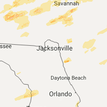
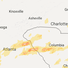
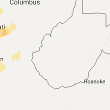
Hail Map for Wednesday, April 5, 2017

Number of Impacted Households on 4/5/2017
0
Impacted by 1" or Larger Hail
0
Impacted by 1.75" or Larger Hail
0
Impacted by 2.5" or Larger Hail
Square Miles of Populated Area Impacted on 4/5/2017
0
Impacted by 1" or Larger Hail
0
Impacted by 1.75" or Larger Hail
0
Impacted by 2.5" or Larger Hail


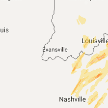
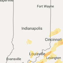


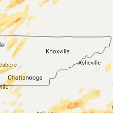

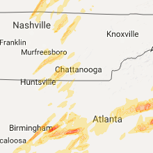


Cities Most Affected by Hail Storms of 4/5/2017
| Hail Size | Demographics of Zip Codes Affected | ||||||
|---|---|---|---|---|---|---|---|
| City | Count | Average | Largest | Pop Density | House Value | Income | Age |
| Munford, AL | 4 | 2.63 | 3.00 | 55 | $77k | $37.0k | 39.3 |
| Pell City, AL | 4 | 2.44 | 2.75 | 214 | $81k | $31.2k | 36.2 |
| Heflin, AL | 4 | 2.06 | 2.50 | 37 | $75k | $29.6k | 40.8 |
| Birmingham, AL | 3 | 2.00 | 2.50 | 1049 | $165k | $56.2k | 39.4 |
| Talladega, AL | 3 | 1.83 | 2.00 | 76 | $69k | $30.7k | 39.6 |
| Bowling Green, KY | 3 | 1.75 | 1.75 | 184 | $81k | $27.7k | 28.6 |
| Lincoln, AL | 2 | 2.13 | 2.50 | 96 | $89k | $33.8k | 39.5 |
| Jemison, AL | 2 | 1.88 | 2.00 | 83 | $83k | $32.9k | 36.6 |
| Lincolnton, GA | 2 | 1.75 | 1.75 | 39 | $84k | $31.8k | 44.4 |
| Roanoke, AL | 1 | 2.50 | 2.50 | 58 | $60k | $29.9k | 39.4 |
| Bolivia, NC | 1 | 2.00 | 2.00 | 76 | $110k | $35.2k | 46.5 |
| Richmond, KY | 1 | 2.00 | 2.00 | 202 | $99k | $32.4k | 32.5 |
| Wellington, AL | 1 | 1.75 | 1.75 | 91 | $76k | $33.2k | 41.2 |
| Ashburn, GA | 1 | 1.75 | 1.75 | 33 | $57k | $22.4k | 38.0 |
| Fitzgerald, GA | 1 | 1.75 | 1.75 | 66 | $61k | $27.4k | 37.3 |
| Southport, NC | 1 | 1.75 | 1.75 | 239 | $151k | $40.1k | 53.3 |
| Bardstown, KY | 1 | 1.75 | 1.75 | 202 | $90k | $40.0k | 36.4 |
| Mc Cormick, SC | 1 | 1.75 | 1.75 | 28 | $79k | $32.2k | 54.9 |
| West Columbia, SC | 1 | 1.75 | 1.75 | 896 | $95k | $45.3k | 37.7 |
| Red Boiling Springs, TN | 1 | 1.75 | 1.75 | 43 | $56k | $27.0k | 41.6 |
| Lockport, KY | 1 | 1.75 | 1.75 | 13 | $34k | $41.3k | 46.1 |
| Manchester, TN | 1 | 1.75 | 1.75 | 122 | $85k | $35.8k | 38.8 |
| Alvaton, KY | 1 | 1.75 | 1.75 | 118 | $105k | $50.6k | 42.0 |
| Smiths Station, AL | 1 | 1.75 | 1.75 | 277 | $89k | $42.9k | 37.8 |
| Temple, GA | 1 | 1.75 | 1.75 | 228 | $86k | $38.4k | 34.0 |
| Palmetto, GA | 1 | 1.75 | 1.75 | 153 | $95k | $39.7k | 36.3 |
| Tybee Island, GA | 1 | 1.75 | 1.75 | 298 | $180k | $50.4k | 53.5 |
| Greensburg, KY | 1 | 1.75 | 1.75 | 47 | $53k | $24.2k | 42.9 |
| Pleasureville, KY | 1 | 1.75 | 1.75 | 36 | $80k | $41.3k | 40.7 |
| Palmyra, IN | 1 | 1.75 | 1.75 | 101 | $92k | $41.0k | 39.7 |
| Anniston, AL | 1 | 1.75 | 1.75 | 539 | $46k | $20.8k | 38.2 |
| Boston, KY | 1 | 1.75 | 1.75 | 40 | $78k | $36.4k | 42.7 |
| Gordonsville, TN | 1 | 1.75 | 1.75 | 72 | $88k | $43.3k | 37.9 |
| Wedowee, AL | 1 | 1.75 | 1.75 | 39 | $74k | $26.5k | 45.3 |
| Camden, AL | 1 | 1.75 | 1.75 | 19 | $59k | $18.0k | 40.1 |
| Floyds Knobs, IN | 1 | 1.75 | 1.75 | 261 | $142k | $63.7k | 42.9 |
| Georgetown, IN | 1 | 1.75 | 1.75 | 292 | $126k | $56.1k | 40.0 |
Hail and Wind Damage Spotted on 4/5/2017
Filter by Report Type:Hail ReportsWind Reports
States Impacted
Alabama, Georgia, South Carolina, Illinois, Florida, Kentucky, Indiana, Tennessee, Ohio, North CarolinaAlabama
| Local Time | Report Details |
|---|---|
| 7:39 AM CDT | Tree down near the intersection of county road 5 and bishop road in clay county. estimated 40-50 mph wind in clay county AL, 44.3 miles NNW of Auburn, AL |
| 7:41 AM CDT | Tree down blocking westover road near old highway 280. estimated 40-50 mph wind in shelby county AL, 12.5 miles SE of Birmingham, AL |
| 8:36 AM CDT | Trees down blocking dickinson road in clarke county AL, 29.4 miles WSW of Camden, AL |
| 9:10 AM CDT | Golf Ball sized hail reported near Camden, AL, 0.2 miles S of Camden, AL, pictures on social media of ping pong to golf ball size hail in camden |
| 9:10 AM CDT | Quarter sized hail reported near Camden, AL, 0.2 miles S of Camden, AL, quarter size hail reported in camden |
| 10:15 AM CDT | Trees down at boykin avenue and don circle. one power line dow in dale county AL, 79.7 miles S of Auburn, AL |
| 10:25 AM CDT | Quarter sized hail reported near Montgomery, AL, 56.8 miles ENE of Camden, AL |
| 10:53 AM CDT | Many trees and power lines down along state route 95 near holly and calhoun drives in the white oak subdivision. this could possibly be tornado damage and will be inves in henry county AL, 60.9 miles SSE of Auburn, AL |
| 12:45 PM CDT | Tree down on house. estimated 40-50 mph wind in shelby county AL, 16.3 miles SE of Birmingham, AL |
| 1:17 PM CDT | Two weekend homes had been heavily damaged from fallen trees. several other trees down in the area. possible tornad in barbour county AL, 60.5 miles SSE of Auburn, AL |
| 3:36 PM CDT | Golf Ball sized hail reported near Talladega, AL, 39.4 miles E of Birmingham, AL |
| 3:36 PM CDT | Hen Egg sized hail reported near Talladega, AL, 39.4 miles E of Birmingham, AL, hail ranging from quarter to hen egg (1" - 2"). |
| 3:42 PM CDT | Golf Ball sized hail reported near Talladega, AL, 40.6 miles E of Birmingham, AL |
| 3:50 PM CDT | Ping Pong Ball sized hail reported near Ohatchee, AL, 49.5 miles ENE of Birmingham, AL |
| 3:54 PM CDT | Hen Egg sized hail reported near Munford, AL, 50.3 miles E of Birmingham, AL |
| 3:54 PM CDT | Baseball sized hail reported near Munford, AL, 50.3 miles E of Birmingham, AL, a few reports of baseball-sized hail in the munford area. |
| 3:54 PM CDT | Tea Cup sized hail reported near Munford, AL, 50.3 miles E of Birmingham, AL, hail stone measured at 3" in diameter. |
| 3:54 PM CDT | Baseball sized hail reported near Munford, AL, 49.7 miles E of Birmingham, AL, several more reports of baseball-sized hail reported in the munford area. |
| 4:05 PM CDT | Half Dollar sized hail reported near Oxford, AL, 57 miles E of Birmingham, AL |
| 4:10 PM CDT | Golf Ball sized hail reported near Anniston, AL, 56.5 miles E of Birmingham, AL |
| 4:11 PM CDT | Golf Ball sized hail reported near Wellington, AL, 61.5 miles ENE of Birmingham, AL |
| 4:11 PM CDT | Half Dollar sized hail reported near Jacksonville, AL, 63.5 miles ENE of Birmingham, AL |
| 4:12 PM CDT | Trees down across the road at stemley road and renfroe roa in talladega county AL, 33.4 miles E of Birmingham, AL |
| 4:15 PM CDT | Quarter sized hail reported near Piedmont, AL, 67.5 miles ENE of Birmingham, AL |
| 4:20 PM CDT | Trees blown down on county line roa in talladega county AL, 49.9 miles E of Birmingham, AL |
| 4:23 PM CDT | Hen Egg sized hail reported near Heflin, AL, 66.1 miles N of Auburn, AL, golfball- to tennis ball-sized hail. time corrected (estimated). |
| 4:23 PM CDT | Hen Egg sized hail reported near Heflin, AL, 69.4 miles N of Auburn, AL |
| 4:28 PM CDT | Golf Ball sized hail reported near Heflin, AL, 68.8 miles W of Atlanta, GA |
| 4:39 PM CDT | Tennis Ball sized hail reported near Heflin, AL, 66.1 miles N of Auburn, AL, golfball- to tennis ball-sized hail. |
| 4:40 PM CDT | Tree downe in cleburne county AL, 60.8 miles WSW of Atlanta, GA |
| 4:45 PM CDT | Quarter sized hail reported near Cedar Bluff, AL, 58.1 miles SSW of Chattanooga, TN, quarter size hail hail on cr 9. |
| 4:55 PM CDT | Quarter sized hail reported near Huntsville, AL, 61.9 miles E of Florence, AL, quarter size hail in medical district of huntsville hospital. |
| 4:56 PM CDT | Quarter sized hail reported near Huntsville, AL, 61.9 miles E of Florence, AL, quarter size hail on jordan road in huntsville. |
| 5:12 PM CDT | Quarter sized hail reported near Wadley, AL, 38.2 miles N of Auburn, AL |
| 5:26 PM CDT | Quarter sized hail reported near Bessemer, AL, 20.4 miles SSW of Birmingham, AL |
| 5:28 PM CDT | Quarter sized hail reported near Bessemer, AL, 19.5 miles SSW of Birmingham, AL |
| 5:30 PM CDT | Quarter sized hail reported near Birmingham, AL, 11.1 miles S of Birmingham, AL |
| 5:30 PM CDT | Tennis Ball sized hail reported near Roanoke, AL, 38.5 miles N of Auburn, AL |
| 5:38 PM CDT | Quarter sized hail reported near Birmingham, AL, 9 miles S of Birmingham, AL |
| 5:40 PM CDT | Quarter sized hail reported near Birmingham, AL, 9.7 miles S of Birmingham, AL |
| 5:45 PM CDT | Quarter sized hail reported near Birmingham, AL, 7.8 miles SSE of Birmingham, AL |
| 5:46 PM CDT | Quarter sized hail reported near Birmingham, AL, 7.1 miles SSE of Birmingham, AL |
| 5:50 PM CDT | Quarter sized hail reported near Leeds, AL, 15.8 miles E of Birmingham, AL |
| 5:50 PM CDT | Golf Ball sized hail reported near Birmingham, AL, 7.3 miles SE of Birmingham, AL, colonnade shopping area. |
| 5:52 PM CDT | Golf Ball sized hail reported near Birmingham, AL, 6.3 miles SE of Birmingham, AL |
| 5:55 PM CDT | Golf Ball sized hail reported near Jemison, AL, 40.1 miles S of Birmingham, AL |
| 5:55 PM CDT | Hen Egg sized hail reported near Jemison, AL, 40.1 miles S of Birmingham, AL |
| 5:57 PM CDT | Tennis Ball sized hail reported near Birmingham, AL, 7.6 miles E of Birmingham, AL |
| 6:00 PM CDT | Half Dollar sized hail reported near Trussville, AL, 15.8 miles ENE of Birmingham, AL |
| 6:00 PM CDT | Ping Pong Ball sized hail reported near Trussville, AL, 15.8 miles ENE of Birmingham, AL |
| 6:04 PM CDT | Several trees blown down around arg in st. clair county AL, 20.5 miles NE of Birmingham, AL |
| 6:05 PM CDT | Quarter sized hail reported near Trussville, AL, 20.5 miles NE of Birmingham, AL |
| 6:07 PM CDT | Quarter sized hail reported near Odenville, AL, 27 miles ENE of Birmingham, AL |
| 6:08 PM CDT | Quarter sized hail reported near Wedowee, AL, 50.5 miles N of Auburn, AL, quarter size hail covering the ground. |
| 6:10 PM CDT | Quarter sized hail reported near Margaret, AL, 23.4 miles ENE of Birmingham, AL |
| 6:10 PM CDT | Golf Ball sized hail reported near Wedowee, AL, 48.4 miles N of Auburn, AL |
| 6:14 PM CDT | Baseball sized hail reported near Pell City, AL, 31 miles E of Birmingham, AL |
| 6:14 PM CDT | Hen Egg sized hail reported near Pell City, AL, 31 miles E of Birmingham, AL |
| 6:15 PM CDT | Quarter sized hail reported near Odenville, AL, 26.5 miles ENE of Birmingham, AL |
| 6:20 PM CDT | Tennis Ball sized hail reported near Pell City, AL, 31 miles E of Birmingham, AL |
| 6:22 PM CDT | Tennis Ball sized hail reported near Pell City, AL, 31 miles E of Birmingham, AL |
| 6:26 PM CDT | Golf Ball sized hail reported near Lincoln, AL, 40.4 miles E of Birmingham, AL |
| 6:26 PM CDT | Tennis Ball sized hail reported near Lincoln, AL, 40.4 miles E of Birmingham, AL |
| 7:04 PM CDT | Quarter sized hail reported near Piedmont, AL, 71.8 miles W of Atlanta, GA |
| 7:15 PM CDT | Quarter sized hail reported near Fort Payne, AL, 47.9 miles SSW of Chattanooga, TN, quarter size hail reported in downtown fort payne... near interstate 59. |
| 7:45 PM CDT | Quarter sized hail reported near Goodwater, AL, 49.9 miles SE of Birmingham, AL, lots of hail ranging from pea to quarter size around hanover. |
| 8:22 PM CDT | A large tree was blown down and blocking the roa in elmore county AL, 37.8 miles W of Auburn, AL |
| 8:40 PM CDT | Radar detected tds in northwest chambers count in chambers county AL, 27.9 miles N of Auburn, AL |
| 8:41 PM CDT | Several trees blown down. possible tornad in chambers county AL, 27 miles N of Auburn, AL |
| 8:42 PM CDT | Several trees blown down. possible tornad in chambers county AL, 27.7 miles N of Auburn, AL |
| 9:31 PM CDT | Quarter sized hail reported near Opelika, AL, 6.6 miles ENE of Auburn, AL |
| 9:37 PM CDT | Quarter sized hail reported near Opelika, AL, 6.6 miles ENE of Auburn, AL |
| 9:38 PM CDT | Quarter sized hail reported near Opelika, AL, 8 miles SE of Auburn, AL |
| 10:03 PM CDT | Quarter sized hail reported near Salem, AL, 14.1 miles E of Auburn, AL |
| 10:04 PM CDT | Quarter sized hail reported near Salem, AL, 18.9 miles E of Auburn, AL |
| 10:05 PM CDT | Golf Ball sized hail reported near Smiths Station, AL, 22.8 miles ESE of Auburn, AL |
| 10:07 PM CDT | Trees were blown down in and around smiths statio in lee county AL, 23.3 miles ESE of Auburn, AL |
Georgia
| Local Time | Report Details |
|---|---|
| 8:44 AM EDT | Golf Ball sized hail reported near Palmetto, GA, 21.1 miles SW of Atlanta, GA, reports of golf ball sized hail was being reported by the fire chief in chattahoochee hills near the intersection of wilkerson mill rd and cascade palmetto hwy |
| 10:00 AM EDT | Large tree down blocking deshong rd in gwinnett county GA, 17.8 miles ENE of Atlanta, GA |
| 10:16 AM EDT | Small tree limbs down... less than 2 inch in diamete in banks county GA, 60.6 miles WSW of Greenville, SC |
| 11:48 AM EDT | Metal roof blown off of bilding...multiple trees down with home damage. possible tornado sightin in clay county GA, 61.9 miles SSE of Auburn, AL |
| 11:50 AM EDT | A tree was blown over in the road near the intersection of castle dr and gloster rd sw in gwinnett county GA, 29.4 miles NE of Atlanta, GA |
| 12:04 PM EDT | Tree down on house...possible tornado in the area in quitman county GA, 60.4 miles SSE of Auburn, AL |
| 12:10 PM EDT | Half Dollar sized hail reported near Tyrone, GA, 22.3 miles SSW of Atlanta, GA, half dollar-sized hail reported in tyrone. |
| 12:26 PM EDT | Golf Ball sized hail reported near Lincolnton, GA, 42.2 miles NW of Augusta, GA, lincoln county em reported golf-ball size hail from goshen northward to the county line. |
| 1:30 PM EDT | Quarter sized hail reported near Union Point, GA, 70 miles E of Atlanta, GA, quarter-sized hail reported in penfield ga |
| 2:10 PM EDT | Golf Ball sized hail reported near Lincolnton, GA, 33.3 miles WNW of Augusta, GA, lincoln county em reported golf-ball size hail occurring on greenwood church road near the county line. |
| 2:46 PM EDT | Social media through broadcast media that a tree was down on power lines along west lake forest driv in richmond county GA, 5.5 miles W of Augusta, GA |
| 3:20 PM EDT | Quarter sized hail reported near Arabi, GA, 57 miles WNW of Douglas, GA, quarter sized hail confirmed in arabi |
| 3:28 PM EDT | Half Dollar sized hail reported near Sycamore, GA, 48.7 miles WNW of Douglas, GA, spotter reports 1.25 inch hail in sycamore...edited for location |
| 3:28 PM EDT | Quarter sized hail reported near Ashburn, GA, 49.2 miles WNW of Douglas, GA, spotter reports hail of 1 inch in ashburn |
| 3:45 PM EDT | Golf Ball sized hail reported near Ashburn, GA, 49.2 miles WNW of Douglas, GA, media relayed report and photo of golf ball size hail via twitter. |
| 4:01 PM EDT | Golf Ball sized hail reported near Fitzgerald, GA, 30.7 miles NW of Douglas, GA, report of golf ball sized hail in ben hill county |
| 5:21 PM EDT | Bulloch county 911 reported a tree down on garfield stree in bulloch county GA, 49.1 miles WNW of Savannah, GA |
| 5:23 PM EDT | Bulloch county 911 reported a tree down on red fern lane near statesbor in bulloch county GA, 47.8 miles NW of Savannah, GA |
| 5:24 PM EDT | Bulloch county 911 reported a tree down on w c hodges r in bulloch county GA, 51.7 miles NW of Savannah, GA |
| 5:34 PM EDT | Bulloch county 911 reported a tree down at the intersection of maria sorrell road and bell road in bulloch county GA, 49.1 miles NW of Savannah, GA |
| 5:34 PM EDT | Trees down along maria sorrel road...one leaning power pole. roadway not blocke in bulloch county GA, 49 miles NW of Savannah, GA |
| 5:38 PM EDT | Screven county 911 reported a tree down on rocky ford r in screven county GA, 54.2 miles SSE of Augusta, GA |
| 5:40 PM EDT | Quarter sized hail reported near Waco, GA, 53.8 miles W of Atlanta, GA, quarter-sized hail spotted in haralson county about a half mile south of i-20. |
| 5:43 PM EDT | Bulloch county 911 reported a tree down at the intersection of harville road and jim waters road in bulloch county GA, 42.6 miles WNW of Savannah, GA |
| 5:43 PM EDT | Trees down along the daisy nevills highway at mosley road. time estimated based on rada in evans county GA, 44.2 miles WNW of Savannah, GA |
| 5:50 PM EDT | Half Dollar sized hail reported near Bremen, GA, 45.6 miles W of Atlanta, GA, quarter to half dollar sized hail on i-20 at exit 5 |
| 6:04 PM EDT | Quarter sized hail reported near Lumber City, GA, 27.3 miles N of Douglas, GA, quarter-sized hail reported on fishing creek road |
| 6:04 PM EDT | Tree reported down on hwy 117 southwest of lumber cit in telfair county GA, 26.6 miles NNE of Douglas, GA |
| 6:18 PM EDT | Half Dollar sized hail reported near Lyons, GA, 45.7 miles NE of Douglas, GA, quarter to half dollar sized hail off sam beasley road |
| 6:43 PM EDT | Quarter sized hail reported near Franklin, GA, 41.4 miles NNE of Auburn, AL |
| 6:53 PM EDT | Trees and power lines down around the city of douglas. portion of a roof collapsed on a home in dougla in coffee county GA, 0.3 miles N of Douglas, GA |
| 8:27 PM EDT | Quarter sized hail reported near Lakeland, GA, 34.6 miles SSW of Douglas, GA, hail of 1 inch reported in lanier county |
| 8:27 PM EDT | Ping Pong Ball sized hail reported near Lakeland, GA, 30.2 miles SSW of Douglas, GA, em reported hail of 1.5 inches in the sirmans area of lanier county. |
| 8:42 PM EDT | Tree down on bugle lane at highway 31 in irwin county GA, 29.2 miles W of Douglas, GA |
| 8:57 PM EDT | Tree down on vickers road in irwin county GA, 14.2 miles NW of Douglas, GA |
| 9:10 PM EDT | Tree and powerlines reported down in canton on oakdale road off of knox bridge highway in cherokee county GA, 33.2 miles NNW of Atlanta, GA |
| 9:29 PM EDT | Golf Ball sized hail reported near Temple, GA, 34.5 miles W of Atlanta, GA, golf ball sized hail reported near hwy 101 and hwy 120 in paulding county. |
| 10:25 PM EDT | Quarter sized hail reported near Lagrange, GA, 36.2 miles NE of Auburn, AL, quarter sized hail reported in the pyne road area |
| 11:00 PM EDT | Quarter sized hail reported near Dacula, GA, 33.7 miles NE of Atlanta, GA, quarter-sized hail reported near ga-324 and ga-124. |
| 11:05 PM EDT | Trees and powerlines down along us-27 north of hamilton. power out in parts of hamilton in harris county GA, 37.2 miles ENE of Auburn, AL |
| 11:07 PM EDT | Ping Pong Ball sized hail reported near Auburn, GA, 37 miles ENE of Atlanta, GA, ping pong ball sized hail reported in auburn ga |
| 11:08 PM EDT | Quarter sized hail reported near Gainesville, GA, 52.4 miles NE of Atlanta, GA, quarter sized hail and rainfall rates at 3.5 inches per hour at the hall county eoc |
| 11:35 PM EDT | Quarter sized hail reported near Commerce, GA, 62.2 miles NE of Atlanta, GA, public reported quarter-sized hail at the quiktrip near commerce |
| 11:38 PM EDT | Trees down at intersection of 14th street and w poplar street in griffin in spalding county GA, 34.9 miles S of Atlanta, GA |
| 11:45 PM EDT | Quarter sized hail reported near Carnesville, GA, 52 miles SW of Greenville, SC, general public reported quarter size hail ssw of carnesville |
| 11:49 PM EDT | Quarter sized hail reported near Royston, GA, 48.7 miles SW of Greenville, SC, trained spotter reported dime to quarter (1") size hail in franklin springs |
| 11:50 PM EDT | Quarter sized hail reported near Tybee Island, GA, 14.4 miles ESE of Savannah, GA, observed near andrea drive. |
| 11:50 PM EDT | Quarter sized hail reported near Tybee Island, GA, 15.2 miles ESE of Savannah, GA, hail for about 10 minutes on jones avenue |
| 11:52 PM EDT | Quarter sized hail reported near , , 15.7 miles ESE of Savannah, GA, hail observed on 2nd ave. |
| 11:52 PM EDT | Ping Pong Ball sized hail reported near Tybee Island, GA, 14.2 miles ESE of Savannah, GA |
| 11:55 PM EDT | Golf Ball sized hail reported near Tybee Island, GA, 14.2 miles ESE of Savannah, GA |
| 12:00 AM EDT | Quarter sized hail reported near Canon, GA, 41.1 miles SSW of Greenville, SC, trained spotter reported quarter (1") size hail on bethany bowersville rd. |
| 12:00 AM EDT | Quarter sized hail reported near Hartwell, GA, 33.2 miles SW of Greenville, SC, public reported quarter size hail on reed creek. |
| 12:00 AM EDT | Emergency mngr reported about a half dozen homes damaged in southern hart county...two by falling trees and the others with roofs partially torn off. numerous trees wer in hart county GA, 38 miles SSW of Greenville, SC |
| 2:15 AM EDT | Tree down in st marys near ready street. time estimated from rada in camden county GA, 27 miles NNE of Jacksonville, FL |
| 2:25 AM EDT | Scattered power outages across waynesville area. wind gusts estimated to 35-45 mp in brantley county GA, 62.4 miles N of Jacksonville, FL |
South Carolina
| Local Time | Report Details |
|---|---|
| 12:27 PM EDT | Golf Ball sized hail reported near Mc Cormick, SC, 44.2 miles NW of Augusta, GA, ongoing large hail and gusty winds at hwy 81 and morrah bridge road. |
| 12:53 PM EDT | Quarter sized hail reported near Newberry, SC, 57.9 miles NNE of Augusta, GA, media via social media posted image of 1 inch hail in newberry. |
| 1:13 PM EDT | Roof blown off furniture stor in edgefield county SC, 26.2 miles NNE of Augusta, GA |
| 1:18 PM EDT | Trees dow in edgefield county SC, 27.3 miles NNE of Augusta, GA |
| 1:19 PM EDT | Trees blocking roa in edgefield county SC, 26.8 miles NNE of Augusta, GA |
| 1:22 PM EDT | Grain silo heavily damaged and multiple trees along with power lines down at hwy 39 and murphy farm roa in saluda county SC, 31.6 miles NNE of Augusta, GA |
| 1:25 PM EDT | County em reported tree down on hous in saluda county SC, 29.8 miles NNE of Augusta, GA |
| 1:25 PM EDT | Trees down near the first baptist churc in edgefield county SC, 26.8 miles NNE of Augusta, GA |
| 1:30 PM EDT | Trained spotter reported multiple trees down on cars in dealership lot.. several cars damage in saluda county SC, 31.4 miles NE of Augusta, GA |
| 1:30 PM EDT | Trees down near the first baptist churc in edgefield county SC, 26.8 miles NNE of Augusta, GA |
| 1:45 PM EDT | Numerous trees down hwy 23 between ward and ridge spring blocking roadwa in saluda county SC, 30.1 miles NNE of Augusta, GA |
| 1:46 PM EDT | Ping Pong Ball sized hail reported near Leesville, SC, 40.5 miles NE of Augusta, GA, amateur radio operator reported ping-pong ball size hail on main street in beatesburg-leesville... sc. |
| 1:50 PM EDT | Broadcast media reported with images significant wind damage to a mobile home in gilbert. radar indicated a possible tornado in the are in lexington county SC, 45.9 miles NE of Augusta, GA |
| 2:09 PM EDT | Social media picture through broadcast media of a tree down across railroad avenue in lexingto in lexington county SC, 54.7 miles NE of Augusta, GA |
| 2:12 PM EDT | Trees blocking highwa in aiken county SC, 7.5 miles ENE of Augusta, GA |
| 2:20 PM EDT | Golf Ball sized hail reported near West Columbia, SC, 58.9 miles NE of Augusta, GA, public reported golf ball size hail at the enterprise car lot near the columbia metropolitan airport. |
| 2:21 PM EDT | Tree down blocking roadway dogwood trail at woodside roa in lexington county SC, 57.7 miles NE of Augusta, GA |
| 2:22 PM EDT | Reported a couple small trees down near the platt springs road entrance to the columbia metro airpor in lexington county SC, 58.5 miles NE of Augusta, GA |
| 2:23 PM EDT | 68 mph wind gust recorded at the columbia metropolitan airport (kcae) aso in lexington county SC, 58.6 miles ENE of Augusta, GA |
| 2:45 PM EDT | A social media report through local broadcast media of a tree uprooted and landed on a small shed. along with a nearby large hardwood tree snappe in richland county SC, 69.2 miles ENE of Augusta, GA |
| 2:46 PM EDT | County reported power lines down at garner's ferry and trotter roa in richland county SC, 69.6 miles ENE of Augusta, GA |
| 3:21 PM EDT | Schp reports trees in roadway 1735 hatchaway bridge road at langdon roa in aiken county SC, 24.2 miles ENE of Augusta, GA |
| 4:50 PM EDT | Quarter sized hail reported near Latta, SC, 85.2 miles W of Wilmington, NC, media relayed report of brief period of quarter sized hail. |
| 5:00 PM EDT | *** 1 inj *** oak tree fell into home. two vehicles damaged. one child injured and sent to hospital in florence. hail of unknown size fel in dillon county SC, 85.2 miles W of Wilmington, NC |
| 5:10 PM EDT | Power lines down on sc highway 9 near pee dee church roa in dillon county SC, 80 miles W of Wilmington, NC |
| 5:46 PM EDT | Power lines down on sc highway 9 near pee dee church roa in dillon county SC, 80 miles W of Wilmington, NC |
| 6:00 PM EDT | Quarter sized hail reported near Conway, SC, 62.6 miles NE of Charleston, SC, relayed by media. |
| 7:04 PM EDT | Schp reported a tree on the roadway near the intersection of highway 17 and wiggins roa in colleton county SC, 47.5 miles NNE of Savannah, GA |
| 7:55 PM EDT | Quarter sized hail reported near Charleston, SC, 26.8 miles S of Charleston, SC |
| 7:55 PM EDT | Quarter sized hail reported near Charleston, SC, 26.9 miles S of Charleston, SC, spotter reported quarter size hail in carolina bay. |
| 7:55 PM EDT | Quarter sized hail reported near Johns Island, SC, 27.9 miles SSW of Charleston, SC, downpour of hail up to the size of quarters...most of it falling as dime to nickel size. |
| 7:59 PM EDT | Ping Pong Ball sized hail reported near Charleston, SC, 25.4 miles S of Charleston, SC, 1.25 to 1.5 inch hail |
| 8:00 PM EDT | Half Dollar sized hail reported near Charleston, SC, 27.6 miles S of Charleston, SC, social media picture indicated hail larger that quarter sized fell on indaba way. |
| 8:00 PM EDT | Half Dollar sized hail reported near Charleston, SC, 27.3 miles S of Charleston, SC |
| 8:04 PM EDT | Quarter sized hail reported near Charleston, SC, 27.3 miles S of Charleston, SC, observed near the intersection of highway 61 and glenn mcconnell parkway. |
| 8:15 PM EDT | The weatherflow site at the isle of palms pier measured a 50 knot wind gus in amz350 county SC, 31.5 miles SSE of Charleston, SC |
| 8:20 PM EDT | Large tree down in the moss park are in charleston county SC, 29.1 miles SSE of Charleston, SC |
| 12:05 AM EDT | Amateur radio reported metal roof blown off abandoned building at sc hwy 253 and sc hwy 29 in greenville county SC, 18 miles NE of Greenville, SC |
| 12:07 AM EDT | Fire dept reported a storage building roof blown off on walnut hill d in pickens county SC, 1.4 miles S of Greenville, SC |
| 12:13 AM EDT | Schp reported a tree down at carrington ln and parker bowie rd in anderson county SC, 36.4 miles S of Greenville, SC |
| 12:15 AM EDT | Emergency mngr reported numerous trees and powerlines down on hwy 81 south at clyde arnold r in anderson county SC, 29.4 miles S of Greenville, SC |
| 12:15 AM EDT | Em reports damage to structures trees and power lines. at least one roof reportedly torn off structure. roadway is blocked in both directions. no injuries reporte in anderson county SC, 34.8 miles S of Greenville, SC |
| 12:16 AM EDT | Schp reported a tree down at wright school rd and highway 28 in anderson county SC, 33.9 miles S of Greenville, SC |
| 12:16 AM EDT | Anderson regional airport asos reported a wind gust of 70 mph in anderson county SC, 24.3 miles SSW of Greenville, SC |
| 12:16 AM EDT | Schp reported a tree down at rainey rd and devonshire rd in anderson county SC, 31.9 miles SSW of Greenville, SC |
| 12:17 AM EDT | Emergency mngr reported numerous trees down in star in anderson county SC, 31.6 miles S of Greenville, SC |
| 12:17 AM EDT | Emergency mngr reported numerous trees down blocking hwy 81 at the starr fire departmen in anderson county SC, 32.2 miles S of Greenville, SC |
| 12:20 AM EDT | Schp reported a tree down at due west highway and old emerson bridge rd in anderson county SC, 29.1 miles S of Greenville, SC |
| 12:20 AM EDT | Fire dept/rescue reported trees and power lines down on due west hw in anderson county SC, 28.5 miles SSE of Greenville, SC |
| 12:20 AM EDT | Fire dept/rescue reported trees and power lines down on highway 28 in anderson county SC, 29.7 miles S of Greenville, SC |
| 12:25 AM EDT | Schp reported a tree down at highway 252 and griffin farm rd in anderson county SC, 28.9 miles SSE of Greenville, SC |
| 12:30 AM EDT | Half Dollar sized hail reported near Belton, SC, 25.7 miles SSE of Greenville, SC, trained spotter reported half dollar (1.25") size hail between belton and honea path |
| 12:30 AM EDT | 911 call center reported numerous trees blown down in the town of honea path...with main st still blocked and closed by fallen tree in anderson county SC, 28.6 miles SSE of Greenville, SC |
| 12:30 AM EDT | Public reported a tree down destroying a deck and a pool on blue forest l in anderson county SC, 6.4 miles ESE of Greenville, SC |
| 12:31 AM EDT | Schp reported a tree down at old gunter rd and bessie rd in greenville county SC, 13.7 miles SE of Greenville, SC |
| 12:35 AM EDT | Emergency mngr reported a tree down on pine dr in piedmon in greenville county SC, 14.1 miles SE of Greenville, SC |
| 12:42 AM EDT | Emergency mngr reported tree down on house on standing springs rd in greenville county SC, 16.9 miles ESE of Greenville, SC |
| 12:43 AM EDT | Quarter sized hail reported near Simpsonville, SC, 20.9 miles ESE of Greenville, SC, trained spotter reported quarter (1") size hail in simpsonville |
| 12:45 AM EDT | Schp reported a tree down on poole st in spartanburg county SC, 32.9 miles E of Greenville, SC |
| 12:45 AM EDT | Schp reported a tree down at ekom beach rd poplar springs rd and indian mound rd in laurens county SC, 37.8 miles SE of Greenville, SC |
| 12:49 AM EDT | Schp reported a tree down at harris bridge rd and boggy branch rd in laurens county SC, 33.5 miles ESE of Greenville, SC |
| 12:51 AM EDT | Schp reported a tree down at highway 252 and mill ham dr in laurens county SC, 36.9 miles SE of Greenville, SC |
| 12:51 AM EDT | Emergency mngr reported trees down on fred dean rd in anderson county SC, 30.6 miles S of Greenville, SC |
| 12:51 AM EDT | Emergency mngr reported trees down on pruitt rd in anderson county SC, 34.1 miles S of Greenville, SC |
| 12:51 AM EDT | Emergency mngr reported a tree down on charles beaty rd in anderson county SC, 33.3 miles S of Greenville, SC |
| 12:51 AM EDT | Emergency mngr reported trees down on parker bowie r in anderson county SC, 34.2 miles S of Greenville, SC |
| 12:54 AM EDT | Emergency mngr reported trees down on middleton r in anderson county SC, 30.5 miles S of Greenville, SC |
| 12:55 AM EDT | Emergency mngr reported trees down on old emerson bridge rd. at hwy 185 in anderson county SC, 29.1 miles S of Greenville, SC |
| 12:55 AM EDT | Schp reported a tree down at stagecoach rd and tomahawk ln in laurens county SC, 38.3 miles SE of Greenville, SC |
| 1:04 AM EDT | Schp reported a tree down at horseshoe rd and princeton highway in anderson county SC, 28.1 miles SSE of Greenville, SC |
| 1:59 AM EDT | Roof damage on sc highway 41 in anderson county SC, 35.3 miles S of Greenville, SC |
Illinois
| Local Time | Report Details |
|---|---|
| 2:08 PM CDT | Significant roof damage to home and tree slammed through garage. damage oriented northwest to southeast. occurred on cameron dr near dogwood r in jackson county IL, 34.9 miles NE of Cape Girardeau, MO |
| 3:22 PM CDT | Half Dollar sized hail reported near Mc Leansboro, IL, 53.3 miles W of Evansville, IN, viewer submitted picture slightly larger than quarter sized. |
| 3:34 PM CDT | Another enfield report. possible tornado. witnesses saw funnel. large trees 4 feet in diameter uprooted. tree tops twisted and broke apart. some car ports were lifted a in white county IL, 43.2 miles WNW of Evansville, IN |
| 3:34 PM CDT | Another enfield report. possible tornado. witnesses saw funnel. large trees 4 feet in diameter uprooted. tree tops twisted and broke apart. some car ports were lifted a in white county IL, 43.2 miles WNW of Evansville, IN |
| 3:34 PM CDT | Another enfield report. possible tornado. witnesses saw funnel. large trees 4 feet in diameter uprooted. tree tops twisted and broke apart. some car ports were lifted a in white county IL, 43.2 miles WNW of Evansville, IN |
| 3:49 PM CDT | Quarter sized hail reported near Olney, IL, 55.1 miles NNW of Evansville, IN, pea to quarter size hail at 500 north and route 130...south of olney and west of calhoun. |
| 4:09 PM CDT | Quarter sized hail reported near Claremont, IL, 54.6 miles SSE of Mattoon, IL, reported 1 mile north of route 50. |
Florida
| Local Time | Report Details |
|---|---|
| 3:28 PM EDT | Half Dollar sized hail reported near Quincy, FL, 33.6 miles WNW of Tallahassee, FL, spotter reports 1.25 inch hail in sycamore |
| 12:26 AM EDT | Law enforcement reported tree down across road on county road 24 in suwannee county FL, 74.2 miles E of Tallahassee, FL |
| 12:35 AM EDT | Law enforcement reported a tree down just east of jasper. the time given was based on rada in hamilton county FL, 68.2 miles S of Douglas, GA |
| 2:00 AM EDT | Tree down on sr-200 near callahan. power lines taken down by tree. power outages reported in the are in nassau county FL, 19.7 miles NNW of Jacksonville, FL |
| 3:15 AM EDT | Backyard gazebo heavily damage in clay county FL, 24.3 miles SW of Jacksonville, FL |
| 5:45 AM EDT | Media reported power line down on highway 42 near weirsdal in marion county FL, 44.8 miles NW of Orlando, FL |
| 5:48 AM EDT | Middle tampa bay buoy reported a 59 mph wind gus in gmz830 county FL, 11.4 miles N of Bradenton, FL |
Kentucky
| Local Time | Report Details |
|---|---|
| 2:58 PM CDT | Ping Pong Ball sized hail reported near Harned, KY, 41.3 miles WSW of Louisville, KY |
| 4:10 PM CDT | Shingles off a home near warren east high schoo in warren county KY, 63.8 miles NNE of Nashville, TN |
| 4:10 PM CDT | Storm damage reported in warren county KY, 62.4 miles NNE of Nashville, TN |
| 4:17 PM CDT | Quarter sized hail reported near Brownsville, KY, 64.8 miles SW of Louisville, KY |
| 4:17 PM CDT | Power lines dow in edmonson county KY, 58.4 miles SSW of Louisville, KY |
| 4:21 PM CDT | Power lines down on ky 7 in breckinridge county KY, 31.4 miles W of Louisville, KY |
| 4:22 PM CDT | Quarter sized hail reported near Bowling Green, KY, 57.8 miles NNE of Nashville, TN |
| 4:23 PM CDT | Golf Ball sized hail reported near Bowling Green, KY, 59.6 miles NNE of Nashville, TN |
| 4:23 PM CDT | Golf Ball sized hail reported near Bowling Green, KY, 58.9 miles NNE of Nashville, TN, veterans memorial parkway and morgantown road. |
| 5:25 PM EDT | Quarter sized hail reported near Elizabethtown, KY, 21.5 miles SSW of Louisville, KY |
| 4:29 PM CDT | Barn damage in warren county KY, 67.7 miles NNE of Nashville, TN |
| 5:30 PM EDT | Tree blown on to a mobile home in the woodland mobile home par in hardin county KY, 20.8 miles SSW of Louisville, KY |
| 5:30 PM EDT | Storm damage reported in shelby county KY, 22.2 miles NE of Louisville, KY |
| 5:30 PM EDT | Mobile home blown ove in hardin county KY, 20.5 miles SSW of Louisville, KY |
| 4:34 PM CDT | Golf Ball sized hail reported near Bowling Green, KY, 68 miles NNE of Nashville, TN |
| 4:34 PM CDT | Power lines dow in warren county KY, 68 miles NNE of Nashville, TN |
| 5:45 PM EDT | Golf Ball sized hail reported near Boston, KY, 14.6 miles S of Louisville, KY |
| 4:46 PM CDT | Golf Ball sized hail reported near Alvaton, KY, 54 miles NNE of Nashville, TN |
| 5:47 PM EDT | Quarter sized hail reported near Boston, KY, 14.6 miles S of Louisville, KY |
| 4:50 PM CDT | Trees down... building damage... power lines dow in metcalfe county KY, 59.2 miles S of Louisville, KY |
| 5:53 PM EDT | A roof was blown off a modular home. four to 5 barns were destroyed. a mobile home was destroyed near watkins lane. trees were downed. boards were peeled off a fenc in henry county KY, 41 miles NE of Louisville, KY |
| 5:55 PM EDT | Quarter sized hail reported near Pleasureville, KY, 45.7 miles NE of Louisville, KY |
| 5:55 PM EDT | Barns down along point pleasant roa in henry county KY, 43.2 miles NE of Louisville, KY |
| 6:00 PM EDT | Golf Ball sized hail reported near Bardstown, KY, 18.6 miles SE of Louisville, KY |
| 6:00 PM EDT | Quarter sized hail reported near Coxs Creek, KY, 18.8 miles ESE of Louisville, KY |
| 5:03 PM CDT | Barns flattened between glasgow and hisevill in barren county KY, 63.8 miles S of Louisville, KY |
| 6:03 PM EDT | Golf Ball sized hail reported near Pleasureville, KY, 48.7 miles NE of Louisville, KY |
| 6:06 PM EDT | Golf Ball sized hail reported near Lockport, KY, 50.4 miles NE of Louisville, KY |
| 6:06 PM EDT | Quarter sized hail reported near Pleasureville, KY, 39.8 miles NE of Louisville, KY |
| 5:12 PM CDT | Barn destroye in green county KY, 55.7 miles S of Louisville, KY |
| 5:13 PM CDT | Quarter sized hail reported near Burkesville, KY, 82.4 miles ENE of Nashville, TN |
| 6:14 PM EDT | Tree down on greenup rd. barn debris from unknown source location also on greenup rd. time estimated from rada in owen county KY, 48.4 miles SSW of Cincinnati, OH |
| 6:15 PM EDT | Quarter sized hail reported near Coxs Creek, KY, 18.8 miles ESE of Louisville, KY |
| 5:18 PM CDT | Building wall blown dow in cumberland county KY, 81.4 miles S of Louisville, KY |
| 5:25 PM CDT | Trees dow in green county KY, 51.6 miles SSE of Louisville, KY |
| 5:25 PM CDT | Golf Ball sized hail reported near Greensburg, KY, 51.6 miles SSE of Louisville, KY |
| 6:34 PM EDT | Storm damage reported in franklin county KY, 44.8 miles E of Louisville, KY |
| 6:36 PM EDT | Tree down on race track rd. couple of powerlines down in several locations throughout the county. time estimated from rada in campbell county KY, 16.6 miles SSE of Cincinnati, OH |
| 6:40 PM EDT | Tree down on daugherty ave and miller pik in marion county KY, 38.1 miles SE of Louisville, KY |
| 6:43 PM EDT | Half Dollar sized hail reported near Campbellsville, KY, 49.6 miles SSE of Louisville, KY |
| 6:45 PM EDT | Trees down reported at pearidge rd... frankfort... k in franklin county KY, 45.1 miles ENE of Louisville, KY |
| 6:55 PM EDT | Small tree limbs dow in scott county KY, 46.6 miles NW of Irvine, KY |
| 7:00 PM EDT | Trees dow in scott county KY, 43.5 miles NW of Irvine, KY |
| 7:03 PM EDT | Scattered tree damage throughout county... particularly in northern half. time estimated from rada in pendleton county KY, 26.7 miles SSE of Cincinnati, OH |
| 7:05 PM EDT | Damage to roof reported at scott county high schoo in scott county KY, 48.9 miles NW of Irvine, KY |
| 7:15 PM EDT | Report of a roof off a house on spruce drive and ky state hwy 36 in harrison county KY, 50.3 miles S of Cincinnati, OH |
| 7:20 PM EDT | Trees and power lines down at hwy 34 and taylor r in boyle county KY, 41.4 miles W of Irvine, KY |
| 7:35 PM EDT | Trees down on power lines. 300 to 400 customers in jessamine county without powe in jessamine county KY, 32.8 miles WNW of Irvine, KY |
| 7:50 PM EDT | Shingles blown off a home. one inch tree limbs snappe in fayette county KY, 32.9 miles NW of Irvine, KY |
| 8:04 PM EDT | Hen Egg sized hail reported near Richmond, KY, 24.7 miles WNW of Irvine, KY |
| 8:05 PM EDT | Quarter sized hail reported near Lexington, KY, 28.9 miles NW of Irvine, KY |
| 8:07 PM EDT | Quarter sized hail reported near Richmond, KY, 21.5 miles WNW of Irvine, KY, hail half inch to quarter size. |
| 8:17 PM EDT | Power lines down. tree on a hous in clark county KY, 23.8 miles NNW of Irvine, KY |
| 8:37 PM EDT | Trees down on highway 8 in powell county KY, 9.7 miles N of Irvine, KY |
| 8:46 PM EDT | Trees dow in powell county KY, 9.7 miles NE of Irvine, KY |
| 8:48 PM EDT | Two trees down at intersections of main street and science ridge roa in montgomery county KY, 20.2 miles NNE of Irvine, KY |
| 8:48 PM EDT | Trees down on highway 60. power lines down in salt lick and olympia spring in bath county KY, 34.6 miles NNE of Irvine, KY |
| 8:54 PM EDT | Trees down on highway 36 east at olympi in bath county KY, 31.4 miles NNE of Irvine, KY |
| 9:06 PM EDT | Trees down on highway 172 in rowan county KY, 38.2 miles NE of Irvine, KY |
| 9:06 PM EDT | Trees down on hawkins branch roa in menifee county KY, 20.9 miles NE of Irvine, KY |
| 9:12 PM EDT | Trees down on christian stree in rowan county KY, 43.5 miles NE of Irvine, KY |
| 9:50 PM EDT | Several trees down throughout carter count in carter county KY, 70.8 miles NE of Irvine, KY |
| 10:10 PM EDT | Several trees down in carter county KY, 60.3 miles NE of Irvine, KY |
Indiana
| Local Time | Report Details |
|---|---|
| 4:27 PM EDT | Quarter sized hail reported near Scipio, IN, 56.2 miles SSE of Indianapolis, IN |
| 4:40 PM EDT | Quarter sized hail reported near Greensburg, IN, 46.3 miles SE of Indianapolis, IN |
| 4:42 PM EDT | Golf Ball sized hail reported near Georgetown, IN, 25 miles NNW of Louisville, KY |
| 4:46 PM EDT | Quarter sized hail reported near Georgetown, IN, 23.6 miles NNW of Louisville, KY |
| 4:51 PM EDT | Quarter sized hail reported near Georgetown, IN, 22.5 miles NNW of Louisville, KY |
| 4:52 PM EDT | Golf Ball sized hail reported near Floyds Knobs, IN, 24.2 miles NNW of Louisville, KY |
| 5:07 PM EDT | Quarter sized hail reported near Ramsey, IN, 32.9 miles NW of Louisville, KY |
| 5:11 PM EDT | Half Dollar sized hail reported near Palmyra, IN, 36.8 miles NW of Louisville, KY |
| 5:17 PM EDT | Golf Ball sized hail reported near Palmyra, IN, 36.1 miles NW of Louisville, KY |
| 5:30 PM EDT | Quarter sized hail reported near Lynn, IN, 66.9 miles ENE of Indianapolis, IN, report from off-duty police officer and relayed through em. |
| 7:06 PM EDT | Quarter sized hail reported near Nashville, IN, 44.2 miles SSW of Indianapolis, IN |
| 7:06 PM EDT | Part of large tree snapped and brought down power line in monroe county IN, 44.2 miles SSW of Indianapolis, IN |
| 7:18 PM EDT | Quarter sized hail reported near Nashville, IN, 39.4 miles S of Indianapolis, IN, relayed via law enforcement. |
Tennessee
| Local Time | Report Details |
|---|---|
| 3:50 PM CDT | Trees reported down in the county with scattered power outages. time estimated based on rada in bedford county TN, 50.2 miles SSE of Nashville, TN |
| 3:55 PM CDT | Trees reported down in the county with scattered power outages. time estimated based on rada in bedford county TN, 50.2 miles SSE of Nashville, TN |
| 3:57 PM CDT | Half Dollar sized hail reported near Fayetteville, TN, 63.2 miles SSE of Nashville, TN, half-dollar size hail in belleville. |
| 3:59 PM CDT | Quarter sized hail reported near Fayetteville, TN, 63.2 miles SSE of Nashville, TN, quarter size hail in belleville. |
| 3:59 PM CDT | Roof blown off house and barn destroye in bedford county TN, 54.2 miles SSE of Nashville, TN |
| 4:18 PM CDT | Golf Ball sized hail reported near Manchester, TN, 57.2 miles NW of Chattanooga, TN, at mile marker 105 |
| 4:19 PM CDT | Quarter sized hail reported near Murfreesboro, TN, 37.5 miles SE of Nashville, TN |
| 4:26 PM CDT | Quarter sized hail reported near Manchester, TN, 54 miles NW of Chattanooga, TN |
| 4:30 PM CDT | Quarter sized hail reported near Watertown, TN, 36 miles E of Nashville, TN |
| 4:31 PM CDT | Ping Pong Ball sized hail reported near Watertown, TN, 36.4 miles E of Nashville, TN, mping report |
| 4:34 PM CDT | Quarter sized hail reported near Manchester, TN, 50.5 miles NW of Chattanooga, TN, picture of various hail sizes ranging from penny to quarter size |
| 4:36 PM CDT | Golf Ball sized hail reported near Gordonsville, TN, 41.3 miles E of Nashville, TN |
| 4:40 PM CDT | Quarter sized hail reported near Carthage, TN, 47.3 miles E of Nashville, TN, facebook image of quarter size hail |
| 4:45 PM CDT | Quarter sized hail reported near Morrison, TN, 51.4 miles NW of Chattanooga, TN, nickel and quarter size hail between 445 pm and 450 pm |
| 4:53 PM CDT | Half Dollar sized hail reported near Red Boiling Springs, TN, 64.1 miles ENE of Nashville, TN, quarter to half dollar size hail. |
| 4:58 PM CDT | Quarter sized hail reported near Tullahoma, TN, 56.1 miles WNW of Chattanooga, TN |
| 5:02 PM CDT | Quarter sized hail reported near Lafayette, TN, 49.5 miles ENE of Nashville, TN, image of several quarter size hailstones |
| 5:02 PM CDT | Quarter sized hail reported near Whitleyville, TN, 67.7 miles ENE of Nashville, TN, image of hail slightly larger than a quarter |
| 5:03 PM CDT | *** 1 inj *** law enforcement reports a mobile home was destroyed. one minor injury. possible tornado. time estimated based on rada in warren county TN, 51.7 miles NNW of Chattanooga, TN |
| 5:03 PM CDT | *** 1 inj *** law enforcement reports a mobile home was destroyed. one minor injury. possible tornado. time estimated based on rada in warren county TN, 45 miles NNW of Chattanooga, TN |
| 5:07 PM CDT | Quarter sized hail reported near Manchester, TN, 52.4 miles NW of Chattanooga, TN, nickel to quarter size hail ongoing |
| 5:09 PM CDT | Golf Ball sized hail reported near Red Boiling Springs, TN, 57.5 miles ENE of Nashville, TN |
| 5:40 PM CDT | Quarter sized hail reported near Cowan, TN, 41.1 miles WNW of Chattanooga, TN, slightly larger than quarter size hail in cowan. |
| 5:45 PM CDT | Quarter sized hail reported near Sewanee, TN, 36.2 miles WNW of Chattanooga, TN, quarter size hail reported in sewanee. |
| 6:06 PM CDT | Quarter sized hail reported near Whitwell, TN, 15.6 miles WNW of Chattanooga, TN |
| 6:14 PM CDT | Quarter sized hail reported near Silver Point, TN, 56.5 miles E of Nashville, TN, mostly nickel size hail but a few quarters mixed in |
| 6:30 PM CDT | Quarter sized hail reported near Dunlap, TN, 22.8 miles NNW of Chattanooga, TN, hail ranged in size from a nickel to a quarter. |
| 9:22 PM EDT | Trees down in and around the knoxville area. report seen on knoxville police department twitter accoun in knox county TN, 1.8 miles WNW of Knoxville, TN |
Ohio
| Local Time | Report Details |
|---|---|
| 5:44 PM EDT | Numerous trees down in oxford township. time estimated from rada in butler county OH, 30.8 miles NNW of Cincinnati, OH |
| 6:06 PM EDT | Quarter sized hail reported near Gratis, OH, 37.5 miles N of Cincinnati, OH |
| 6:06 PM EDT | Tree dow in preble county OH, 37.5 miles N of Cincinnati, OH |
| 6:18 PM EDT | Tin roof of a barn pulled back. time estimated from rada in montgomery county OH, 43.4 miles N of Cincinnati, OH |
| 6:18 PM EDT | Several large limbs downed. pieces of a barn tin roof blown off. time estimated from rada in montgomery county OH, 44.7 miles N of Cincinnati, OH |
| 6:32 PM EDT | Dime sized hail as wel in hamilton county OH, 1.6 miles NE of Cincinnati, OH |
| 6:37 PM EDT | Storm damage reported in montgomery county OH, 56.8 miles NNE of Cincinnati, OH |
| 6:38 PM EDT | Quarter sized hail reported near Dayton, OH, 48.1 miles NNE of Cincinnati, OH |
| 6:43 PM EDT | Storm damage reported in montgomery county OH, 55.9 miles NNE of Cincinnati, OH |
| 6:45 PM EDT | Storm damage reported in greene county OH, 55.5 miles NNE of Cincinnati, OH |
| 6:49 PM EDT | Entire tree uprooted in a yard on dayton-springfield rd. time estimated from rada in greene county OH, 53 miles W of Columbus, OH |
| 6:54 PM EDT | Quarter sized hail reported near Medway, OH, 55.4 miles W of Columbus, OH |
| 6:55 PM EDT | Several large tree limbs down near enon rd. time estimated from rada in clark county OH, 49.4 miles W of Columbus, OH |
| 7:01 PM EDT | Tree down throughout county... especially in williamsburg area. time estimated from rada in clermont county OH, 24.8 miles E of Cincinnati, OH |
| 7:06 PM EDT | Branches down in brown county OH, 31.9 miles E of Cincinnati, OH |
| 7:07 PM EDT | Numerous instances of tree damage in northern part of county. a roof of a trailer was blown off near e main st. time estimated from rada in brown county OH, 31.9 miles E of Cincinnati, OH |
| 7:08 PM EDT | One large limb 6 inches in diameter downe in brown county OH, 32.5 miles E of Cincinnati, OH |
| 7:12 PM EDT | Tree down on greenbush rd. time estimated from rada in highland county OH, 34.7 miles E of Cincinnati, OH |
| 7:12 PM EDT | Tree down on beltz rd. time estimated from rada in highland county OH, 34.7 miles E of Cincinnati, OH |
| 7:29 PM EDT | Tree down along green rd. time estimated from rada in highland county OH, 48.3 miles E of Cincinnati, OH |
| 7:30 PM EDT | Tree down near berrysville rd. time estimated from rada in highland county OH, 50.8 miles E of Cincinnati, OH |
| 7:53 PM EDT | Branch down along lower twin road. time estimated from rada in ross county OH, 46.7 miles SSW of Columbus, OH |
| 8:19 PM EDT | Several trees down in western part of county... including on davis rd... greenridge rd... and along rte 22 in pike county OH, 54.8 miles S of Columbus, OH |
| 8:32 PM EDT | Several trees downed in saltcreek township. time estimated from rada in pickaway county OH, 33.2 miles SSE of Columbus, OH |
North Carolina
| Local Time | Report Details |
|---|---|
| 7:12 PM EDT | Quarter sized hail reported near Ocean Isle Beach, NC, 37 miles SW of Wilmington, NC, hail increasing from dime at 708 pm to quarter-sized at 712 pm. |
| 7:16 PM EDT | Quarter sized hail reported near Supply, NC, 33.1 miles SW of Wilmington, NC |
| 7:17 PM EDT | Ping Pong Ball sized hail reported near , , 28.4 miles SW of Wilmington, NC, 2 miles west of intercoastal waterway bridge. |
| 7:18 PM EDT | Half Dollar sized hail reported near Supply, NC, 29.2 miles SW of Wilmington, NC, hail from quarter to half dollar sizedl. |
| 7:26 PM EDT | Hen Egg sized hail reported near Bolivia, NC, 21.9 miles SW of Wilmington, NC, 2 inch hail near sunset harbor realyed by media. time estimated based off radar. |
| 7:30 PM EDT | Golf Ball sized hail reported near Southport, NC, 23.3 miles SSW of Wilmington, NC |
| 12:37 AM EDT | Quarter sized hail reported near Morganton, NC, 58.1 miles NW of Charlotte, NC, broadcast media reported quarter (1") size hail on amherst rd and zion rd in morganton. |
| 12:56 AM EDT | Quarter sized hail reported near Valdese, NC, 55.1 miles NW of Charlotte, NC, broadcast media reported quarter (1") size hail onlovelady rd in valdese. |
| 1:08 AM EDT | Half Dollar sized hail reported near Hickory, NC, 45.1 miles NW of Charlotte, NC, general public reported half dollar size hail near st. stephens |
| 2:25 AM EDT | Tree down on road and power lines near hillside drive and mowery driv in forsyth county NC, 69.9 miles NE of Charlotte, NC |
| 5:45 AM EDT | Quarter sized hail reported near Julian, NC, 58.3 miles W of Raleigh, NC, hail up to the size of quarters. |
| 5:56 AM EDT | Quarter sized hail reported near Whitsett, NC, 57.5 miles WNW of Raleigh, NC, dime to quarter-sized hail reported at the bojangles and mcdonalds at exit 135 on i-85/40. |
| 6:14 AM EDT | Quarter sized hail reported near Yanceyville, NC, 58.1 miles NW of Raleigh, NC, report from the public relayed by local media. |
| 7:45 AM EDT | Quarter sized hail reported near Durham, NC, 18 miles NW of Raleigh, NC |
Connect with Interactive Hail Maps