

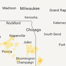
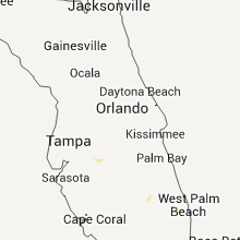
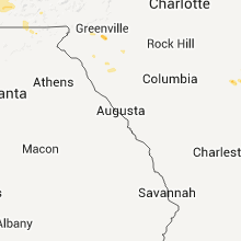
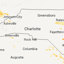
Hail Map for Sunday, June 19, 2011

Number of Impacted Households on 6/19/2011
0
Impacted by 1" or Larger Hail
0
Impacted by 1.75" or Larger Hail
0
Impacted by 2.5" or Larger Hail
Square Miles of Populated Area Impacted on 6/19/2011
0
Impacted by 1" or Larger Hail
0
Impacted by 1.75" or Larger Hail
0
Impacted by 2.5" or Larger Hail


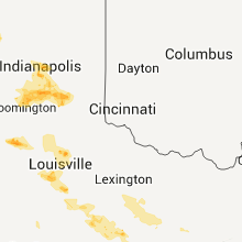


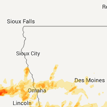


Cities Most Affected by Hail Storms of 6/19/2011
| Hail Size | Demographics of Zip Codes Affected | ||||||
|---|---|---|---|---|---|---|---|
| City | Count | Average | Largest | Pop Density | House Value | Income | Age |
| Hayes Center, NE | 4 | 1.94 | 2.50 | 1 | $34k | $26.9k | 47.0 |
| Imperial, NE | 3 | 2.42 | 2.75 | 2 | $67k | $34.4k | 41.3 |
| Westmoreland, TN | 3 | 2.33 | 2.75 | 93 | $71k | $33.1k | 37.4 |
| Arapahoe, NE | 3 | 2.25 | 2.50 | 6 | $45k | $29.4k | 46.4 |
| Cookeville, TN | 3 | 1.83 | 2.00 | 426 | $94k | $28.6k | 33.0 |
| Cambridge, NE | 2 | 2.25 | 2.75 | 3 | $46k | $33.3k | 48.9 |
| Shelby, NE | 2 | 2.25 | 2.75 | 8 | $67k | $39.3k | 41.3 |
| Nebraska City, NE | 2 | 2.25 | 2.50 | 56 | $77k | $35.5k | 41.5 |
| Wallace, KS | 1 | 4.25 | 4.25 | 1 | $11k | $27.5k | 49.1 |
| Elba, NE | 2 | 2.13 | 2.50 | 3 | $73k | $33.8k | 43.9 |
| Julesburg, CO | 2 | 2.00 | 2.00 | 6 | $62k | $28.8k | 48.8 |
| Sparta, TN | 2 | 1.88 | 2.00 | 69 | $78k | $29.3k | 42.2 |
| Stuart, NE | 2 | 1.75 | 1.75 | 2 | $53k | $30.7k | 47.1 |
| Curtis, NE | 2 | 1.75 | 1.75 | 3 | $50k | $32.4k | 32.1 |
| Silver Creek, NE | 2 | 1.75 | 1.75 | 4 | $51k | $36.0k | 43.1 |
| Wauneta, NE | 2 | 1.75 | 1.75 | 1 | $40k | $30.1k | 50.2 |
| Champion, NE | 1 | 2.75 | 2.75 | 2 | $35k | $30.3k | 45.6 |
| White City, KS | 1 | 2.75 | 2.75 | 5 | $40k | $36.2k | 41.6 |
| Newport, NE | 1 | 2.50 | 2.50 | 1 | $15k | $32.7k | 50.8 |
| Crook, CO | 1 | 2.50 | 2.50 | 1 | $53k | $26.0k | 50.8 |
| Oxford, NE | 1 | 2.50 | 2.50 | 3 | $40k | $32.2k | 45.5 |
| Edison, NE | 1 | 2.50 | 2.50 | 1 | $31k | $33.6k | 45.3 |
| Shepherdsville, KY | 1 | 2.25 | 2.25 | 235 | $115k | $44.9k | 38.4 |
| Strasburg, CO | 1 | 2.00 | 2.00 | 21 | $179k | $52.4k | 38.7 |
| Ithaca, NE | 1 | 2.00 | 2.00 | 8 | $63k | $38.6k | 37.4 |
| Padroni, CO | 1 | 2.00 | 2.00 | 0 | $63k | $37.7k | 47.6 |
| Crossville, TN | 1 | 1.75 | 1.75 | 199 | $85k | $28.6k | 42.4 |
| Shoals, IN | 1 | 1.75 | 1.75 | 21 | $53k | $34.2k | 43.1 |
| Holyoke, CO | 1 | 1.75 | 1.75 | 6 | $81k | $32.1k | 41.5 |
| Broken Bow, NE | 1 | 1.75 | 1.75 | 12 | $57k | $31.8k | 42.8 |
| Ovid, CO | 1 | 1.75 | 1.75 | 1 | $44k | $25.9k | 49.2 |
| Union, NE | 1 | 1.75 | 1.75 | 17 | $103k | $42.2k | 43.8 |
| Turkey, NC | 1 | 1.75 | 1.75 | 37 | $61k | $26.9k | 38.5 |
| Palisade, NE | 1 | 1.75 | 1.75 | 2 | $33k | $24.9k | 48.5 |
| Bargersville, IN | 1 | 1.75 | 1.75 | 223 | $110k | $56.8k | 37.3 |
| Conway, SC | 1 | 1.75 | 1.75 | 149 | $87k | $31.4k | 37.3 |
| Amherst, CO | 1 | 1.75 | 1.75 | 2 | $78k | $36.5k | 36.4 |
| Bellwood, NE | 1 | 1.75 | 1.75 | 12 | $70k | $35.8k | 44.4 |
| Manhattan, KS | 1 | 1.75 | 1.75 | 192 | $89k | $27.9k | 24.4 |
| Sidney, IA | 1 | 1.75 | 1.75 | 9 | $64k | $41.0k | 43.3 |
| Junction City, KS | 1 | 1.75 | 1.75 | 128 | $67k | $31.2k | 29.3 |
| Fleming, CO | 1 | 1.75 | 1.75 | 2 | $80k | $32.7k | 44.1 |
| Spencer, TN | 1 | 1.75 | 1.75 | 26 | $54k | $27.2k | 42.9 |
| Elwood, NE | 1 | 1.75 | 1.75 | 9 | $81k | $37.8k | 50.5 |
| Otis, CO | 1 | 1.75 | 1.75 | 2 | $61k | $35.5k | 43.9 |
| Martinsville, IN | 1 | 1.75 | 1.75 | 160 | $115k | $45.8k | 40.4 |
| Stuart, IA | 1 | 1.75 | 1.75 | 17 | $81k | $34.4k | 42.8 |
| Stockville, NE | 1 | 1.75 | 1.75 | 0 | $31k | $35.5k | 63.5 |
| Arnold, NE | 1 | 1.75 | 1.75 | 2 | $39k | $27.5k | 48.8 |
| Louisville, KY | 1 | 1.75 | 1.75 | 2656 | $91k | $37.1k | 36.7 |
| Memphis, MO | 1 | 1.75 | 1.75 | 16 | $50k | $30.1k | 40.0 |
| Scotia, NE | 1 | 1.75 | 1.75 | 2 | $24k | $25.9k | 43.3 |
Hail and Wind Damage Spotted on 6/19/2011
Filter by Report Type:Hail ReportsWind Reports
States Impacted
Kentucky, Indiana, Nebraska, Tennessee, South Carolina, Florida, Wyoming, Illinois, North Carolina, Colorado, Kansas, Iowa, MissouriKentucky
| Local Time | Report Details |
|---|---|
| 12:00 PM UTC | Trees down on coleman roa in meade county KY, 22.2 miles WSW of Louisville, KY |
| 12:06 PM UTC | Shed was blown about 20 feet and destroyed on flowervale lan in jefferson county KY, 11 miles NW of Louisville, KY |
| 12:06 PM UTC | Tree downed on the roof of a home on cedarwood driv in jefferson county KY, 11 miles NW of Louisville, KY |
| 12:06 PM UTC | Tree down on hous in jefferson county KY, 11 miles NW of Louisville, KY |
| 12:15 PM UTC | Large tree dow in jefferson county KY, 7.9 miles N of Louisville, KY |
| 12:23 PM UTC | Limbs down in bullitt county KY, 10.1 miles ENE of Louisville, KY |
| 12:43 PM UTC | Two trees downed by thunderstorm winds along old mumfordville road north of glasgo in barren county KY, 65 miles S of Louisville, KY |
| 12:52 PM UTC | Trees were downed along depot street and 150 valley hill road in springfield in washington county KY, 34.1 miles SE of Louisville, KY |
| 1:18 PM UTC | One tree was downed in junction cit in boyle county KY, 45.3 miles W of Irvine, KY |
| 1:35 PM UTC | Three trees down in stone creek neighborhood in fayette county KY, 35.9 miles NW of Irvine, KY |
| 10:00 PM UTC | Quarter sized hail reported near La Center, KY, 35.5 miles ESE of Cape Girardeau, MO |
| 10:02 PM UTC | Half Dollar sized hail reported near Barlow, KY, 30.5 miles ESE of Cape Girardeau, MO, half dollar to nearly golfball size hail. late report. |
| 10:05 PM UTC | Quarter sized hail reported near Kevil, KY, 39.7 miles ESE of Cape Girardeau, MO |
| 11:09 PM UTC | Quarter sized hail reported near Scottsville, KY, 48.8 miles NE of Nashville, TN, fell near forest springs. |
| 5:47 AM UTC | Quarter sized hail reported near Shepherdsville, KY, 5.1 miles NE of Louisville, KY |
| 1:52 AM EDT | Hen Egg sized hail reported near Shepherdsville, KY, 4.2 miles NE of Louisville, KY, golf ball and larger size hail |
| 5:54 AM UTC | Quarter sized hail reported near Shepherdsville, KY, 5.3 miles E of Louisville, KY |
| 6:10 AM UTC | Several trees dow in laurel county KY, 36.1 miles SSW of Irvine, KY |
| 6:15 AM UTC | Trees down on old way roa in laurel county KY, 39.5 miles S of Irvine, KY |
| 6:25 AM UTC | Golf Ball sized hail reported near Louisville, KY, 10.6 miles N of Louisville, KY, golf ball size hail |
| 7:00 AM UTC | Tree down on hardbell station road near the wasioto golf cours in bell county KY, 55.9 miles NNE of Knoxville, TN |
| 7:10 AM UTC | Trees down on hwy 180 in knox county KY, 53.7 miles N of Knoxville, TN |
| 9:05 AM UTC | Sixty to ninety trees blown down on hwy 92e near the knox county lin in whitley county KY, 50.3 miles N of Knoxville, TN |
Indiana
| Local Time | Report Details |
|---|---|
| 12:01 PM UTC | Trees dow in harrison county IN, 16.9 miles NW of Louisville, KY |
| 12:30 PM UTC | Trees powerlines down near scottsburg in scott county IN, 48.6 miles N of Louisville, KY |
| 12:33 PM UTC | Two trees down along state highway 56 just east of the scott county lin in jefferson county IN, 51.2 miles N of Louisville, KY |
| 6:00 AM UTC | Golf Ball sized hail reported near Shoals, IN, 72.4 miles NE of Evansville, IN, time estimated. |
| 6:03 AM UTC | Quarter sized hail reported near Williams, IN, 71.9 miles SSW of Indianapolis, IN |
| 6:25 AM UTC | Half Dollar sized hail reported near Mitchell, IN, 66.4 miles NW of Louisville, KY, time estimated. |
| 6:29 AM UTC | Quarter sized hail reported near Mitchell, IN, 66.4 miles NW of Louisville, KY |
| 6:36 AM UTC | Half Dollar sized hail reported near Mitchell, IN, 66.4 miles NW of Louisville, KY |
| 4:00 AM EDT | Golf Ball sized hail reported near Martinsville, IN, 27.9 miles SSW of Indianapolis, IN, on columbus st. time estimated. |
| 8:19 AM UTC | Quarter sized hail reported near Greenwood, IN, 12.4 miles S of Indianapolis, IN |
| 8:45 AM UTC | Ping Pong Ball sized hail reported near Greenwood, IN, 10.4 miles SSE of Indianapolis, IN, time estimated. |
| 8:55 AM UTC | Quarter sized hail reported near New Whiteland, IN, 14.5 miles S of Indianapolis, IN, time estimated. |
| 9:37 AM UTC | Quarter sized hail reported near Indianapolis, IN, 0.9 miles N of Indianapolis, IN |
| 9:55 AM UTC | Golf Ball sized hail reported near Bargersville, IN, 17.1 miles S of Indianapolis, IN, time estimated. |
| 11:54 AM UTC | 3 large trees down across roadways in rural areas between 2 and 5 miles northwest of mount ay in newton county IN, 66.7 miles SSE of Chicago, IL |
Nebraska
| Local Time | Report Details |
|---|---|
| 2:23 PM UTC | Imperial asos reported a wind gust of 77 mph. delayed repor in chase county NE, 62.6 miles SW of North Platte, NE |
| 7:55 PM UTC | Ping Pong Ball sized hail reported near Kimball, NE, 51.2 miles S of Scottsbluff, NE |
| 8:50 PM UTC | Strong winds over 60 mph caused extensive large tree damage. structural damage to a home by a fallen tree and pivot irrigation system overturne in chase county NE, 58.8 miles SSW of North Platte, NE |
| 10:25 PM UTC | Quarter sized hail reported near Newport, NE, 37.2 miles W of Oneill, NE, public reported quarter sized hail 5 miles ssw of newport |
| 10:53 PM UTC | Half Dollar sized hail reported near Newport, NE, 36.1 miles WNW of Oneill, NE, quarters and half dollars size hail reported in newport. |
| 11:02 PM UTC | Tennis Ball sized hail reported near Newport, NE, 36.5 miles WNW of Oneill, NE, the hail lasted for 20 minutes. |
| 11:02 PM UTC | Baseball sized hail reported near Imperial, NE, 57.4 miles ENE of Yuma, CO |
| 11:22 PM UTC | Ping Pong Ball sized hail reported near Arnold, NE, 26.7 miles ENE of North Platte, NE, marble to ping pong ball sized hail partially covering the ground |
| 11:36 PM UTC | Golf Ball sized hail reported near Stuart, NE, 27.3 miles WNW of Oneill, NE |
| 11:38 PM UTC | Golf Ball sized hail reported near Stuart, NE, 29.8 miles WNW of Oneill, NE |
| 12:06 AM UTC | Quarter sized hail reported near Atkinson, NE, 24.3 miles NW of Oneill, NE, public reported a few hail stones the size of a quarter...but most were the size of a large marble. |
| 12:12 AM UTC | Golf Ball sized hail reported near Hayes Center, NE, 54.6 miles SSW of North Platte, NE, public reported golf ball sized hail 10 s of hayes center |
| 12:12 AM UTC | Golf Ball sized hail reported near Palisade, NE, 54.1 miles SSW of North Platte, NE, public reported golf ball sized hail 10 sw of hayes center |
| 12:30 AM UTC | Baseball sized hail reported near Imperial, NE, 57.4 miles ENE of Yuma, CO, time of report corrected. |
| 12:39 AM UTC | Quarter sized hail reported near Big Springs, NE, 68.8 miles W of North Platte, NE |
| 12:45 AM UTC | Golf Ball sized hail reported near Hayes Center, NE, 49.9 miles S of North Platte, NE, golf ball sized hail 9 se of hayes center |
| 1:15 AM UTC | Quarter sized hail reported near Brule, NE, 58.9 miles W of North Platte, NE |
| 1:40 AM UTC | Golf Ball sized hail reported near Stockville, NE, 46.4 miles SSE of North Platte, NE |
| 1:59 AM UTC | Half Dollar sized hail reported near Arnold, NE, 41.8 miles NE of North Platte, NE |
| 2:00 AM UTC | Quarter sized hail reported near Hayes Center, NE, 51.4 miles SSW of North Platte, NE |
| 2:05 AM UTC | Golf Ball sized hail reported near Arnold, NE, 35.7 miles ENE of North Platte, NE, time is estimated...this is a delayed report. |
| 2:23 AM UTC | Imperial asos reported a wind gust of 77 mph. delayed repor in chase county NE, 62.6 miles SW of North Platte, NE |
| 2:30 AM UTC | Main transmission lines blown down just north of cambridge. air conditioning units blown off of hospital in cambridg in furnas county NE, 66.8 miles SSE of North Platte, NE |
| 2:38 AM UTC | 45 to 50 mph winds with gusts of 65 mph. also rotation in stor in furnas county NE, 73.5 miles SE of North Platte, NE |
| 2:38 AM UTC | Quarter sized hail reported near Nebraska City, NE, 40.3 miles S of Omaha, NE |
| 2:40 AM UTC | Garage and barn destroyed. trees 1.5 to 2 feet in diameter are down. power lines are also dow in furnas county NE, 69.9 miles SE of North Platte, NE |
| 2:49 AM UTC | Half Dollar sized hail reported near North Platte, NE, 10.1 miles S of North Platte, NE |
| 2:57 AM UTC | Ping Pong Ball sized hail reported near North Platte, NE, 11.5 miles S of North Platte, NE |
| 2:59 AM UTC | Tennis Ball sized hail reported near Arapahoe, NE, 72.8 miles SE of North Platte, NE |
| 3:00 AM UTC | Quarter sized hail reported near Hayes Center, NE, 34.5 miles S of North Platte, NE, delayed report of pea to quarter size hail. storm total rainfall was 1.70 inches at this location. |
| 3:00 AM UTC | Half Dollar sized hail reported near Hayes Center, NE, 47.3 miles SSW of North Platte, NE, delayed report of hail the size of quarters with a few half dollar sized stones. |
| 3:00 AM UTC | Half Dollar sized hail reported near Wauneta, NE, 51.5 miles SW of North Platte, NE, quarter to half dollar sized hail caused siding damage on west side of home along with one broken window. |
| 3:00 AM UTC | Golf Ball sized hail reported near Hayes Center, NE, 44 miles S of North Platte, NE, estimated around 10 pm cdt with extensive crop damage from three separate storm cells. |
| 3:00 AM UTC | Golf Ball sized hail reported near Broken Bow, NE, 69.4 miles ENE of North Platte, NE |
| 3:00 AM UTC | Tennis Ball sized hail reported near Nebraska City, NE, 40.3 miles S of Omaha, NE, hail fell around 10-1015 pm. |
| 3:03 AM UTC | Golf Ball sized hail reported near Elwood, NE, 70.1 miles SE of North Platte, NE, golf ball sized hailed reported near gosper county line |
| 3:05 AM UTC | Golf Ball sized hail reported near Wauneta, NE, 47.2 miles SW of North Platte, NE, delayed report. siding and roof damage caused by golf ball sized hail. |
| 3:05 AM UTC | Storm damage reported in furnas county NE, 76.9 miles SE of North Platte, NE |
| 3:08 AM UTC | Half Dollar sized hail reported near Hayes Center, NE, 47.7 miles SSW of North Platte, NE, hail with 60 mph wind gusts. |
| 3:08 AM UTC | Golf Ball sized hail reported near Arapahoe, NE, 72.8 miles SE of North Platte, NE |
| 3:12 AM UTC | Tennis Ball sized hail reported near Arapahoe, NE, 75.5 miles SE of North Platte, NE |
| 3:12 AM UTC | Tennis Ball sized hail reported near Edison, NE, 70.6 miles SE of North Platte, NE |
| 3:13 AM UTC | Ping Pong Ball sized hail reported near Edison, NE, 77.9 miles SE of North Platte, NE |
| 3:15 AM UTC | Quarter sized hail reported near Sargent, NE, 67.5 miles SSW of Oneill, NE, delayed report from yesterday evening. |
| 3:25 AM UTC | Baseball sized hail reported near Champion, NE, 58.8 miles ENE of Yuma, CO, chase county sheriff reported golf ball and baseball sized hail in champion |
| 3:30 AM UTC | Quarter sized hail reported near Hayes Center, NE, 35.3 miles S of North Platte, NE |
| 3:30 AM UTC | Hen Egg sized hail reported near Nebraska City, NE, 40.3 miles S of Omaha, NE |
| 3:30 AM UTC | Tennis Ball sized hail reported near Hayes Center, NE, 44.7 miles SSW of North Platte, NE, hail ranged from quarter to golf ball size - with some hail as large as tennis balls. roof damage at residence. |
| 3:30 AM UTC | Tennis Ball sized hail reported near Oxford, NE, 79.5 miles SE of North Platte, NE, delayed report. time estimated from radar. |
| 3:35 AM UTC | Golf Ball sized hail reported near Imperial, NE, 62.6 miles SW of North Platte, NE |
| 3:36 AM UTC | Golf Ball sized hail reported near Cambridge, NE, 66.8 miles SSE of North Platte, NE |
| 3:37 AM UTC | Ping Pong Ball sized hail reported near Atlanta, NE, 72.7 miles WSW of Grand Island, NE |
| 3:37 AM UTC | Ping Pong Ball sized hail reported near Oxford, NE, 74.8 miles WSW of Grand Island, NE, corrected for location. |
| 3:45 AM UTC | Ping Pong Ball sized hail reported near Hayes Center, NE, 30.1 miles S of North Platte, NE, delayed report. large hail to ping pong ball size cracked truck windshield and punched holes in vinyl siding on home. |
| 4:15 AM UTC | Golf Ball sized hail reported near Curtis, NE, 34.9 miles SSE of North Platte, NE |
| 4:32 AM UTC | Golf Ball sized hail reported near Union, NE, 31.1 miles S of Omaha, NE |
| 4:40 AM UTC | Ping Pong Ball sized hail reported near Merna, NE, 37.6 miles ENE of North Platte, NE |
| 4:40 AM UTC | Golf Ball sized hail reported near Elba, NE, 34 miles NW of Grand Island, NE, delayed report of hail and 60 mph winds from nebraska rainfall assessment and information network observer. time estimated from radar. |
| 4:53 AM UTC | Tennis Ball sized hail reported near Cotesfield, NE, 33.6 miles NNW of Grand Island, NE |
| 4:55 AM UTC | Quarter sized hail reported near Hayes Center, NE, 51.7 miles S of North Platte, NE, the hail damaged siding. |
| 4:55 AM UTC | Golf Ball sized hail reported near Curtis, NE, 42.8 miles SSE of North Platte, NE, time of report was estimated. |
| 5:01 AM UTC | Quarter sized hail reported near Hayes Center, NE, 52.4 miles S of North Platte, NE |
| 5:14 AM UTC | Hen Egg sized hail reported near Ithaca, NE, 32 miles WSW of Omaha, NE, reports of sky lights being broke out also. |
| 5:35 AM UTC | 2-3 inch diameter tree limbs down. pea to penny size hai in howard county NE, 20.7 miles NNW of Grand Island, NE |
| 5:46 AM UTC | Baseball sized hail reported near Cambridge, NE, 66.8 miles SSE of North Platte, NE, winds estimated at 60 to 70 mph. |
| 6:08 AM UTC | Large tree blown down on power lines. six center pivots flipped ove in dodge county NE, 44.8 miles NW of Omaha, NE |
| 6:10 AM UTC | Two inch diameter tree limbs dow in saunders county NE, 35.4 miles W of Omaha, NE |
| 6:13 AM UTC | 60 to 65 mph winds...heavy rain and nickel size hail. several 6 inch diameter tree limbs down on highway 18 in custer county NE, 65.3 miles WNW of Grand Island, NE |
| 6:15 AM UTC | Half Dollar sized hail reported near Elwood, NE, 67.5 miles SE of North Platte, NE |
| 6:16 AM UTC | Half Dollar sized hail reported near Elwood, NE, 68.6 miles SE of North Platte, NE |
| 6:17 AM UTC | Ping Pong Ball sized hail reported near Elwood, NE, 68.5 miles SE of North Platte, NE |
| 6:30 AM UTC | Golf Ball sized hail reported near Scotia, NE, 47.8 miles NNW of Grand Island, NE, delayed report via nerain observer. golf ball size started around 130am and lasted 15-20 minutes. |
| 6:36 AM UTC | Golf Ball sized hail reported near Wauneta, NE, 58.8 miles SSW of North Platte, NE, chase county sheriff reported golf ball sized hail and very heavy rain in wauneta |
| 6:44 AM UTC | Corrected location from original report to put in merrick county. old elevator blown across highway 30. debris covering the road between clarks and silver creek. power in merrick county NE, 43.1 miles NE of Grand Island, NE |
| 6:44 AM UTC | Old elevator blown across highway 30. debris covering the road between clarks and silver creek. power lines down in clarks and power is out to the town of clark in nance county NE, 43.6 miles NE of Grand Island, NE |
| 7:00 AM UTC | 2 large trees blown down in city par in burt county NE, 54.3 miles NNW of Omaha, NE |
| 7:02 AM UTC | Golf Ball sized hail reported near Silver Creek, NE, 43.1 miles NE of Grand Island, NE, corrected location from original report |
| 7:02 AM UTC | Golf Ball sized hail reported near Silver Creek, NE, 43.6 miles NE of Grand Island, NE |
| 7:05 AM UTC | Baseball sized hail reported near Shelby, NE, 52.1 miles ENE of Grand Island, NE, delayed report from public relayed by omaha national weather service office. |
| 7:11 AM UTC | Quarter sized hail reported near Kearney, NE, 44.7 miles WSW of Grand Island, NE |
| 7:20 AM UTC | Golf Ball sized hail reported near Shelby, NE, 50.5 miles ENE of Grand Island, NE, delayed report of hail which caused broken siding on their home. time estimated from radar. |
| 7:30 AM UTC | Estimated wind gusts up to 60 mp in butler county NE, 64.1 miles ENE of Grand Island, NE |
| 7:35 AM UTC | Golf Ball sized hail reported near Bellwood, NE, 64.1 miles ENE of Grand Island, NE, still a few stones falling at 241 am. |
| 8:27 AM UTC | Storm damage reported in merrick county NE, 13.2 miles ENE of Grand Island, NE |
| 8:30 AM UTC | Storm damage reported in merrick county NE, 21.9 miles NE of Grand Island, NE |
Tennessee
| Local Time | Report Details |
|---|---|
| 4:45 PM UTC | A few trees dow in greene county TN, 45.2 miles SW of Bristol, TN |
| 7:35 PM UTC | Quarter sized hail reported near Powell, TN, 7.8 miles NW of Knoxville, TN |
| 10:47 PM UTC | Golf Ball sized hail reported near Westmoreland, TN, 43.9 miles NE of Nashville, TN |
| 10:57 PM UTC | Tennis Ball sized hail reported near Westmoreland, TN, 41.7 miles NE of Nashville, TN, largest hail measured at 2.25 inches |
| 10:59 PM UTC | Quarter sized hail reported near Westmoreland, TN, 40.4 miles NE of Nashville, TN |
| 11:04 PM UTC | Baseball sized hail reported near Westmoreland, TN, 40 miles NE of Nashville, TN, baseball size hail was reported in the oak grove community at state highway 174 and pleasant grove road. |
| 11:25 PM UTC | Quarter sized hail reported near Lafayette, TN, 48.3 miles ENE of Nashville, TN, dime to quarter sized hail |
| 12:04 AM UTC | Quarter sized hail reported near Gainesboro, TN, 64.4 miles ENE of Nashville, TN |
| 12:14 AM UTC | Quarter sized hail reported near Gainesboro, TN, 64.4 miles ENE of Nashville, TN |
| 7:25 PM CDT | Half Dollar sized hail reported near Cookeville, TN, 70.9 miles E of Nashville, TN |
| 7:26 PM CDT | Golf Ball sized hail reported near Cookeville, TN, 71 miles E of Nashville, TN |
| 7:28 PM CDT | Quarter sized hail reported near Cookeville, TN, 70.9 miles E of Nashville, TN |
| 7:30 PM CDT | Golf Ball sized hail reported near Cookeville, TN, 70.9 miles E of Nashville, TN |
| 12:30 AM UTC | Several trees and powerlines down in and around algood and northeast of cookeville in putnam county TN, 74.3 miles E of Nashville, TN |
| 12:35 AM UTC | Storm damage reported in putnam county TN, 73.2 miles E of Nashville, TN |
| 7:35 PM CDT | Quarter sized hail reported near Cookeville, TN, 70.9 miles E of Nashville, TN |
| 7:36 PM CDT | Quarter sized hail reported near Algood, TN, 74.3 miles E of Nashville, TN |
| 7:36 PM CDT | Hen Egg sized hail reported near Cookeville, TN, 70.9 miles E of Nashville, TN |
| 7:42 PM CDT | Several trees were blown over near the intersection of willow avenue and west cemetery roa in putnam county TN, 70.9 miles E of Nashville, TN |
| 7:45 PM CDT | Partial roof was blown off a building at 265 south jefferson avenu in putnam county TN, 70.9 miles E of Nashville, TN |
| 7:45 PM CDT | Quarter sized hail reported near Cookeville, TN, 70.9 miles E of Nashville, TN |
| 7:55 PM CDT | Half Dollar sized hail reported near Sparta, TN, 61.6 miles N of Chattanooga, TN |
| 1:00 AM UTC | Golf Ball sized hail reported near Crossville, TN, 62.7 miles W of Knoxville, TN |
| 8:15 PM CDT | Golf Ball sized hail reported near Sparta, TN, 64.4 miles N of Chattanooga, TN, golfball hail reported by public in de rossett in white county. |
| 1:28 AM UTC | Quarter sized hail reported near Crossville, TN, 62.7 miles W of Knoxville, TN, 1 inch diameter hail was reported. |
| 1:50 AM UTC | Few tree limbs dow in rhea county TN, 51.1 miles NNE of Chattanooga, TN |
| 9:00 PM CDT | Golf Ball sized hail reported near Spencer, TN, 52.6 miles N of Chattanooga, TN, golfball size hail reported by public on hodges ferry road. |
| 9:00 PM CDT | Hen Egg sized hail reported near Sparta, TN, 61.6 miles N of Chattanooga, TN |
| 2:05 AM UTC | Quarter sized hail reported near Ten Mile, TN, 46.6 miles WSW of Knoxville, TN |
| 2:25 AM UTC | One tree down on big spring gap r in bledsoe county TN, 43.2 miles N of Chattanooga, TN |
| 2:40 AM UTC | Quarter sized hail reported near Madisonville, TN, 41.5 miles SSW of Knoxville, TN |
| 2:55 AM UTC | Tree down on hom in mcminn county TN, 48.8 miles NE of Chattanooga, TN |
| 2:55 AM UTC | Tree down on home at 108 mason stree in mcminn county TN, 48.9 miles NE of Chattanooga, TN |
| 7:45 AM UTC | Multiple trees down in grainger county TN, 44.4 miles NE of Knoxville, TN |
| 8:03 AM UTC | Trees down on highway 25 in claiborne county TN, 38.6 miles NE of Knoxville, TN |
| 8:20 AM UTC | One tree down in hamblen county TN, 46.7 miles ENE of Knoxville, TN |
| 8:30 AM UTC | Trees down on little creek in claiborne county TN, 43 miles NNE of Knoxville, TN |
| 8:30 AM UTC | One tree down on lonesome pine trai in greene county TN, 44.8 miles WSW of Bristol, TN |
| 9:00 AM UTC | Numerous trees down across the eastern portions of the count in claiborne county TN, 45.5 miles NNE of Knoxville, TN |
South Carolina
| Local Time | Report Details |
|---|---|
| 5:50 PM UTC | Tree down on hoyt rogers r in marion county SC, 74.7 miles W of Wilmington, NC |
| 6:19 PM UTC | Quarter sized hail reported near Florence, SC, 66.1 miles NNE of Charleston, SC |
| 7:16 PM UTC | Tree down across sc544 east bound vicinity state road 81 in horry county SC, 69.2 miles NE of Charleston, SC |
| 7:20 PM UTC | Golf Ball sized hail reported near Conway, SC, 64.6 miles NE of Charleston, SC |
| 7:28 PM UTC | Quarter sized hail reported near Myrtle Beach, SC, 68.2 miles ENE of Charleston, SC |
| 7:32 PM UTC | Half Dollar sized hail reported near Myrtle Beach, SC, 67.2 miles ENE of Charleston, SC |
| 7:33 PM UTC | Tree down in the roadway on state rt 54 in horry county SC, 69.2 miles NE of Charleston, SC |
| 7:40 PM UTC | Quarter sized hail reported near , , 68.4 miles ENE of Charleston, SC |
| 7:45 PM UTC | Trees dow in horry county SC, 63.7 miles NE of Charleston, SC |
| 7:46 PM UTC | Quarter sized hail reported near Myrtle Beach, SC, 65.7 miles ENE of Charleston, SC |
| 7:47 PM UTC | Half Dollar sized hail reported near Myrtle Beach, SC, 65.7 miles ENE of Charleston, SC |
| 9:00 PM UTC | Several trees down near the street intersection of main and croft. one tree clipped a house. another tree fell on a couple of parked car in greenville county SC, 13.1 miles E of Greenville, SC |
| 9:09 PM UTC | Tree across road near old mcelhaney rd in greenville county SC, 10 miles NE of Greenville, SC |
| 9:10 PM UTC | Half Dollar sized hail reported near Enoree, SC, 38 miles ESE of Greenville, SC, enoree fd |
| 9:28 PM UTC | Quarter sized hail reported near Simpsonville, SC, 21.7 miles E of Greenville, SC |
| 9:30 PM UTC | Quarter sized hail reported near Simpsonville, SC, 25.5 miles E of Greenville, SC, east georgia rd at fd |
| 9:47 PM UTC | Quarter sized hail reported near Fountain Inn, SC, 28.4 miles ESE of Greenville, SC, hail to size of qua |
| 4:03 AM UTC | Large tree down on rocky ford road. time determined by rada in anderson county SC, 24.6 miles SSE of Greenville, SC |
| 4:10 AM UTC | Trees down at fish hatchery road and hwy 10 in oconee county SC, 26.8 miles WNW of Greenville, SC |
| 4:29 AM UTC | Trees down in oconee county SC, 24.6 miles W of Greenville, SC |
| 4:32 AM UTC | Trees and power lines down on nicole drive near old chapman bridge. fire started in nearby wooded are in oconee county SC, 20.2 miles WNW of Greenville, SC |
| 4:32 AM UTC | Multiple trees and power lines down along highway 11 between salem and lake keowe in oconee county SC, 21.8 miles WNW of Greenville, SC |
| 4:33 AM UTC | Metal roof off house in oconee county SC, 22 miles W of Greenville, SC |
| 4:33 AM UTC | Trees dow in oconee county SC, 22 miles W of Greenville, SC |
| 4:40 AM UTC | Trees down in li in pickens county SC, 6.3 miles WSW of Greenville, SC |
| 4:40 AM UTC | Tree down through house on odell drive off hwy 17 in pickens county SC, 6.9 miles W of Greenville, SC |
| 5:03 AM UTC | Tree blocking simpson road. time determined by rada in anderson county SC, 20.8 miles S of Greenville, SC |
| 5:03 AM UTC | Large tree down on rocky ford road. time determined by rada in anderson county SC, 24.6 miles SSE of Greenville, SC |
| 5:10 AM UTC | Trees down in anderson county SC, 22.2 miles SSE of Greenville, SC |
| 5:41 AM UTC | One tree down on old abbeville highway. time determined by rada in abbeville county SC, 48.3 miles SSE of Greenville, SC |
| 6:35 AM UTC | Roof of barn partially blown off and several large tree limbs down in the yard in lexington county SC, 47.8 miles NE of Augusta, GA |
Florida
| Local Time | Report Details |
|---|---|
| 6:50 PM UTC | Half Dollar sized hail reported near Coral Springs, FL, 37.3 miles N of Miami, FL, skywarn spotter reported half dollar size hail in coral springs. |
| 6:50 PM UTC | Skywarn spotter reported winds of at least 60 mph and pine trees down at eagle trace golf clu in broward county FL, 37.3 miles N of Miami, FL |
| 8:30 PM UTC | A thunderstorm produced a wind gust estimated at 60 mph in hialeah near the flamingo horse track. a few small trees estimated to be 8 to 9 feet tall have been knocked d in miami-dade county FL, 9.6 miles NNW of Miami, FL |
| 11:50 PM UTC | Estimated 50 mph wind gust snapped a tree 10 feet above the ground in pine castl in orange county FL, 4.7 miles S of Orlando, FL |
Wyoming
| Local Time | Report Details |
|---|---|
| 9:07 PM UTC | Quarter sized hail reported near Cheyenne, WY, 43.1 miles ESE of Laramie, WY, mostly pea size. |
| 9:19 PM UTC | Half Dollar sized hail reported near Cheyenne, WY, 43.1 miles ESE of Laramie, WY, on the north side of cheyenne. |
| 9:19 PM UTC | Half Dollar sized hail reported near Cheyenne, WY, 47.7 miles E of Laramie, WY |
Illinois
| Local Time | Report Details |
|---|---|
| 9:20 PM UTC | Quarter sized hail reported near Mound City, IL, 25.8 miles SE of Cape Girardeau, MO, quarter size hail at mound city. |
| 10:56 PM UTC | Quarter sized hail reported near Wonder Lake, IL, 50.7 miles NW of Chicago, IL, dime to quarter sized hail. at pine and thompson roads. |
| 10:59 PM UTC | Half Dollar sized hail reported near Wonder Lake, IL, 50.7 miles NW of Chicago, IL, at pine and thompson roads. |
| 10:45 AM UTC | Storm damage reported in livingston county IL, 51.4 miles ENE of Peoria, IL |
| 11:16 AM UTC | Swath of damage noted starting near county roads 1000n and 7000w...extending northeast. damage to pole barn...with multiple trees uprooted that were 2 plus feet in diam in kankakee county IL, 55.5 miles SSW of Chicago, IL |
| 11:16 AM UTC | Trees down and across warner bridge road...1 mile north of rt 17. estimated diameter of biggest trees were 12-15 inches. time estimated from rada in kankakee county IL, 51.6 miles SSW of Chicago, IL |
North Carolina
| Local Time | Report Details |
|---|---|
| 9:27 PM UTC | Half Dollar sized hail reported near Emerald Isle, NC, 60.3 miles ENE of Wilmington, NC, quarter to half dollar size hail reported in emerald isle beach |
| 9:32 PM UTC | Quarter sized hail reported near Indian Beach, NC, 68 miles ENE of Wilmington, NC, nickel to quarter size hail reported in indian beach |
| 3:10 AM UTC | 2 trees down near 1214 mountain creek roa in graham county NC, 43.5 miles S of Knoxville, TN |
| 3:15 AM UTC | 2 trees down on state road 1122 in the snowbird communit in graham county NC, 47.7 miles S of Knoxville, TN |
| 3:20 AM UTC | Trees and power lines down county wid in cherokee county NC, 60.3 miles S of Knoxville, TN |
| 3:30 AM UTC | Multiple trees down in the nantahala communit in macon county NC, 53.3 miles SSE of Knoxville, TN |
| 3:35 AM UTC | Several trees dow in clay county NC, 64.8 miles S of Knoxville, TN |
| 3:35 AM UTC | 2 trees down along hw-28 nort in macon county NC, 51.4 miles WNW of Greenville, SC |
| 3:40 AM UTC | One tree down near the intersection of jones ridge road and hw-441 sout in macon county NC, 50.4 miles WNW of Greenville, SC |
| 3:50 AM UTC | Tree on powerlines at base of cowee mt in macon county NC, 52.8 miles WNW of Greenville, SC |
| 4:05 AM UTC | Storm damage reported in jackson county NC, 32.2 miles WNW of Greenville, SC |
| 4:05 AM UTC | Numerous trees and powerlines dow in jackson county NC, 34.3 miles NW of Greenville, SC |
| 4:05 AM UTC | Windows and interior doors blown out of hom in jackson county NC, 34.3 miles NW of Greenville, SC |
| 4:25 AM UTC | Quarter sized hail reported near Wilson, NC, 40.8 miles E of Raleigh, NC, hail the size of quarters and very heavy rain fell in downtown wilson on main street |
| 4:47 AM UTC | Quarter sized hail reported near Elizabethtown, NC, 53.2 miles NW of Wilmington, NC, dime to quarter size hail in ammon. time estimated by radar. |
| 5:20 AM UTC | One tree was reported down on a house along east park street near urban driv in wake county NC, 7.2 miles W of Raleigh, NC |
| 5:25 AM UTC | Quarter sized hail reported near Cary, NC, 14.6 miles W of Raleigh, NC, quarter size hail in western cary. |
| 5:28 AM UTC | Golf Ball sized hail reported near Turkey, NC, 53.9 miles NNW of Wilmington, NC |
| 5:30 AM UTC | One tree was reported down across hardimont road near quail hollow driv in wake county NC, 4 miles NNE of Raleigh, NC |
| 5:40 AM UTC | Quarter sized hail reported near , , 53.4 miles N of Wilmington, NC, nickel to quarter size hail reported by police in warsaw. |
| 6:33 AM UTC | One tree was reported down on the corner of a house at east greenwood avenue and north saratoga street in wilson county NC, 47.8 miles ESE of Raleigh, NC |
| 6:40 AM UTC | Tree down on catfish lake road in craven county NC, 68.5 miles NE of Wilmington, NC |
| 7:00 AM UTC | Beaufort asos observed a 66 knot wind gus in carteret county NC, 81.2 miles ENE of Wilmington, NC |
| 7:00 AM UTC | Hanger destroyed at michael smith airport in beaufort in carteret county NC, 81.2 miles ENE of Wilmington, NC |
| 7:20 AM UTC | Quarter sized hail reported near Beaufort, NC, 87.3 miles ENE of Wilmington, NC, public reports nickel to quarter size hail observed in otway. |
| 7:21 AM UTC | Greene county 911 center reports trees down across west greene street in snow hil in greene county NC, 59.4 miles ESE of Raleigh, NC |
| 8:20 AM UTC | Tree down at 500 chelsie road in craven county NC, 75.6 miles NE of Wilmington, NC |
Colorado
| Local Time | Report Details |
|---|---|
| 10:39 PM UTC | Quarter sized hail reported near Peetz, CO, 61.5 miles NNW of Yuma, CO |
| 11:15 PM UTC | Quarter sized hail reported near Crook, CO, 55.9 miles N of Yuma, CO |
| 11:28 PM UTC | Tennis Ball sized hail reported near Crook, CO, 51.3 miles N of Yuma, CO |
| 11:38 PM UTC | Half Dollar sized hail reported near Crook, CO, 54 miles N of Yuma, CO |
| 12:08 AM UTC | Golf Ball sized hail reported near Ovid, CO, 60.7 miles NNE of Yuma, CO |
| 12:17 AM UTC | Half Dollar sized hail reported near Sedgwick, CO, 54 miles NNE of Yuma, CO |
| 12:20 AM UTC | Hen Egg sized hail reported near Julesburg, CO, 62.9 miles NNE of Yuma, CO |
| 12:24 AM UTC | Hen Egg sized hail reported near Julesburg, CO, 63 miles NNE of Yuma, CO |
| 12:30 AM UTC | Golf Ball sized hail reported near Fleming, CO, 39.2 miles N of Yuma, CO, wind gusts estimated at 60 mph |
| 12:30 AM UTC | Golf Ball sized hail reported near Amherst, CO, 48.7 miles NE of Yuma, CO |
| 1:05 AM UTC | Storm damage reported in logan county CO, 39.2 miles N of Yuma, CO |
| 1:06 AM UTC | Hen Egg sized hail reported near Padroni, CO, 50.8 miles NNW of Yuma, CO |
| 1:19 AM UTC | Quarter sized hail reported near Holyoke, CO, 43.8 miles NNE of Yuma, CO |
| 1:57 AM UTC | Golf Ball sized hail reported near Otis, CO, 20.1 miles NNW of Yuma, CO |
| 2:04 AM UTC | Quarter sized hail reported near Keenesburg, CO, 39.7 miles NE of Denver, CO |
| 2:07 AM UTC | Hen Egg sized hail reported near Strasburg, CO, 38.6 miles ENE of Denver, CO |
| 2:18 AM UTC | Quarter sized hail reported near Yuma, CO, 18.8 miles NNE of Yuma, CO, pea to quarter size hail covering the ground. little wind at this time. |
| 2:40 AM UTC | Golf Ball sized hail reported near Holyoke, CO, 32.1 miles NE of Yuma, CO |
| 3:54 AM UTC | Quarter sized hail reported near Woodrow, CO, 46 miles W of Yuma, CO |
| 4:12 AM UTC | Storm damage reported in washington county CO, 25.3 miles WNW of Yuma, CO |
| 4:48 AM UTC | Quarter sized hail reported near Yuma, CO, 0.2 miles ENE of Yuma, CO |
| 5:20 AM UTC | Storm damage reported in yuma county CO, 26.3 miles E of Yuma, CO |
| 9:30 AM UTC | Quarter sized hail reported near Eads, CO, 99.7 miles E of Pueblo, CO |
| 10:23 AM UTC | Radio tower blown down. two 10 inch in diameter trees uprooted. debris strewn across property. time based off radar dat in kiowa county CO, 80.5 miles WNW of Garden City, KS |
| 10:30 AM UTC | Storm damage reported in kiowa county CO, 84.5 miles WNW of Garden City, KS |
| 10:30 AM UTC | Quarter sized hail reported near Sheridan Lake, CO, 84.5 miles WNW of Garden City, KS |
Kansas
| Local Time | Report Details |
|---|---|
| 12:37 AM UTC | Quarter sized hail reported near Chapman, KS, 32.6 miles SW of Manhattan, KS |
| 12:52 AM UTC | Half Dollar sized hail reported near Woodbine, KS, 30.8 miles SW of Manhattan, KS |
| 12:52 AM UTC | Half Dollar sized hail reported near White City, KS, 30.4 miles SSW of Manhattan, KS |
| 12:54 AM UTC | Baseball sized hail reported near White City, KS, 30.4 miles SSW of Manhattan, KS |
| 1:01 AM UTC | Quarter sized hail reported near White City, KS, 29.3 miles SSW of Manhattan, KS |
| 1:52 AM UTC | Golf Ball sized hail reported near Junction City, KS, 20.8 miles SSW of Manhattan, KS, lasted 10 mins. |
| 2:15 AM UTC | Quarter sized hail reported near Fort Riley, KS, 13.4 miles SW of Manhattan, KS, on interstate 70 at exit 303 |
| 2:53 AM UTC | Quarter sized hail reported near Manhattan, KS, 0.4 miles W of Manhattan, KS |
| 2:54 AM UTC | Quarter sized hail reported near Manhattan, KS, 0.4 miles W of Manhattan, KS |
| 2:56 AM UTC | Golf Ball sized hail reported near Manhattan, KS, 4.5 miles NNW of Manhattan, KS, most of the hail was quarter-size |
| 11:06 AM UTC | Top of grainbin blown off with tin lying alongside hwy 27. approximately 5 irrigation pivots blown over along and west of hwy 27. time estimated from rada in wallace county KS, 60.4 miles SW of Colby, KS |
| 11:06 AM UTC | Cedar windbreak severely damaged with several large trees uprooted. semi-truck blown over and shingles blown off house. time estimated by rada in wallace county KS, 62.4 miles SW of Colby, KS |
| 11:10 AM UTC | Also blowing dirt and nickel sized hail in wallace county KS, 55.7 miles SSW of Colby, KS |
| 11:10 AM UTC | Empty grain bins and power poles blown down. irrigation pivots blown over. out-buildings blown down and windows broken from hail. time approximated from rada in wallace county KS, 57.2 miles SW of Colby, KS |
| 11:10 AM UTC | Out-buildings blown dow in wallace county KS, 50.5 miles SW of Colby, KS |
| 11:17 AM UTC | Storm damage reported in wallace county KS, 58.6 miles SW of Colby, KS |
| 11:17 AM UTC | Broken utility poles. time estimate in wallace county KS, 52.2 miles SW of Colby, KS |
| 11:17 AM UTC | Grapefruit sized hail reported near Wallace, KS, 52.2 miles SW of Colby, KS, time estimate |
Iowa
| Local Time | Report Details |
|---|---|
| 3:00 AM UTC | Quarter sized hail reported near Hamburg, IA, 40.3 miles SSE of Omaha, NE |
| 3:00 AM UTC | Quarter sized hail reported near Clarinda, IA, 61.8 miles SE of Omaha, NE |
| 3:33 AM UTC | Ping Pong Ball sized hail reported near Arispe, IA, 54.2 miles SW of Des Moines, IA |
| 3:35 AM UTC | Quarter sized hail reported near Arispe, IA, 54.2 miles SW of Des Moines, IA |
| 4:15 AM UTC | Golf Ball sized hail reported near Sidney, IA, 38.6 miles SSE of Omaha, NE |
| 4:52 AM UTC | Four mature trees downed along with numerous four to six inch in diameter limbs. two different powerlines downed by falling trees. an abandoned mobile home moved off it in ringgold county IA, 64.8 miles SSW of Des Moines, IA |
| 4:56 AM UTC | Half Dollar sized hail reported near Johnston, IA, 11.1 miles NNW of Des Moines, IA, at the nws office in johnston |
| 5:12 AM UTC | Heavy rain and pea hail was also being reported west of leo in decatur county IA, 59.2 miles S of Des Moines, IA |
| 5:15 AM UTC | Significant tree damage in the town of leon. an estimated 100 to 200 trees felled in town with large tree limbs littering the town. trees fell onto the roofs of many ho in decatur county IA, 59.1 miles S of Des Moines, IA |
| 5:45 AM UTC | Storm damage reported in lucas county IA, 42.6 miles SSE of Des Moines, IA |
| 5:48 AM UTC | Ping Pong Ball sized hail reported near Grimes, IA, 9.3 miles WNW of Des Moines, IA |
| 5:53 AM UTC | Awning of camper torn off...some siding taken off house. power ou in lucas county IA, 46.6 miles SSE of Des Moines, IA |
| 5:56 AM UTC | Half Dollar sized hail reported near Johnston, IA, 11.1 miles NNW of Des Moines, IA, at the nws office in johnston |
| 6:15 AM UTC | Numerous small branches and limbs down along with a few portions of larger trees. some of these were blocking part of the road. another tree fell onto a vehicle at the in monroe county IA, 57.4 miles SE of Des Moines, IA |
| 6:15 AM UTC | Numerous small branches and limbs down along with a few portions of larger trees. some of these were blocking portions of the road. another tree fell onto a vehicle at in monroe county IA, 57.4 miles SE of Des Moines, IA |
| 6:17 AM UTC | Storm damage reported in monroe county IA, 57.4 miles SE of Des Moines, IA |
| 7:50 AM UTC | Ping Pong Ball sized hail reported near Fontanelle, IA, 47.4 miles WSW of Des Moines, IA, hail dented pick up truck. |
| 8:08 AM UTC | Ping Pong Ball sized hail reported near Logan, IA, 27.3 miles NNE of Omaha, NE |
| 8:10 AM UTC | Golf Ball sized hail reported near Stuart, IA, 35 miles W of Des Moines, IA |
| 8:11 AM UTC | Quarter sized hail reported near Dexter, IA, 32.2 miles W of Des Moines, IA |
| 9:10 AM UTC | Numerous six inch tree branches down. a 40 to 50 ft tree fell on top of a house. time estimated from rada in cass county IA, 49.3 miles ENE of Omaha, NE |
| 10:05 AM UTC | Numerous trees downed with some trees on top of houses. power lines downed and a storage shead shifted from its foundation. cars thrown into a ditch. winds ripped the f in mahaska county IA, 50.8 miles E of Des Moines, IA |
Missouri
| Local Time | Report Details |
|---|---|
| 5:08 AM UTC | Golf Ball sized hail reported near Memphis, MO, 20.1 miles NW of Kahoka, MO, occurring right now. |
Connect with Interactive Hail Maps