

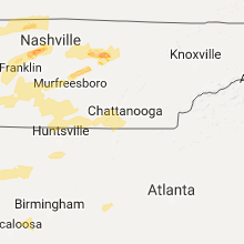
Hail Map for Thursday, March 9, 2017

Number of Impacted Households on 3/9/2017
0
Impacted by 1" or Larger Hail
0
Impacted by 1.75" or Larger Hail
0
Impacted by 2.5" or Larger Hail
Square Miles of Populated Area Impacted on 3/9/2017
0
Impacted by 1" or Larger Hail
0
Impacted by 1.75" or Larger Hail
0
Impacted by 2.5" or Larger Hail


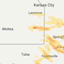


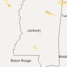
Cities Most Affected by Hail Storms of 3/9/2017
| Hail Size | Demographics of Zip Codes Affected | ||||||
|---|---|---|---|---|---|---|---|
| City | Count | Average | Largest | Pop Density | House Value | Income | Age |
| Carthage, MO | 3 | 2.50 | 3.00 | 133 | $67k | $31.0k | 35.5 |
| Carterville, MO | 3 | 2.17 | 2.75 | 815 | $45k | $29.8k | 34.7 |
| Nevada, MO | 3 | 2.17 | 2.75 | 91 | $65k | $30.9k | 40.0 |
| Grove, OK | 2 | 2.13 | 2.50 | 161 | $104k | $27.4k | 50.1 |
| Jackson, TN | 2 | 2.13 | 2.50 | 393 | $102k | $47.1k | 35.9 |
| Afton, OK | 2 | 1.75 | 1.75 | 53 | $86k | $32.5k | 50.9 |
| Oronogo, MO | 1 | 3.00 | 3.00 | 62 | $69k | $33.8k | 33.0 |
| Wentworth, MO | 1 | 2.75 | 2.75 | 24 | $63k | $32.1k | 40.0 |
| Joplin, MO | 1 | 2.75 | 2.75 | 583 | $68k | $30.4k | 35.1 |
| Stotts City, MO | 1 | 2.50 | 2.50 | 21 | $27k | $32.0k | 40.5 |
| Jasper, MO | 1 | 2.00 | 2.00 | 14 | $54k | $31.2k | 39.1 |
| Ottawa, KS | 1 | 2.00 | 2.00 | 96 | $73k | $37.4k | 35.8 |
| Webb City, MO | 1 | 2.00 | 2.00 | 441 | $72k | $30.4k | 32.4 |
| Appleton City, MO | 1 | 1.75 | 1.75 | 14 | $51k | $27.5k | 46.1 |
| Mathiston, MS | 1 | 1.75 | 1.75 | 35 | $56k | $27.8k | 38.8 |
| Eminence, MO | 1 | 1.75 | 1.75 | 4 | $51k | $23.0k | 46.3 |
| Lamar, MO | 1 | 1.75 | 1.75 | 31 | $64k | $30.9k | 40.8 |
| Creighton, MO | 1 | 1.75 | 1.75 | 19 | $60k | $42.3k | 41.6 |
| Shell Knob, MO | 1 | 1.75 | 1.75 | 52 | $94k | $29.2k | 58.8 |
| Iola, KS | 1 | 1.75 | 1.75 | 65 | $44k | $31.6k | 38.5 |
| Quincy, MO | 1 | 1.75 | 1.75 | 9 | $35k | $17.3k | 60.6 |
| Paola, KS | 1 | 1.75 | 1.75 | 53 | $110k | $46.6k | 41.7 |
| Fort Gibson, OK | 1 | 1.75 | 1.75 | 88 | $76k | $36.3k | 38.2 |
| Amory, MS | 1 | 1.75 | 1.75 | 89 | $69k | $31.7k | 40.9 |
| Locust Grove, OK | 1 | 1.75 | 1.75 | 41 | $58k | $27.3k | 38.7 |
| Golden, MO | 1 | 1.75 | 1.75 | 61 | $89k | $29.2k | 58.5 |
| Mountain View, AR | 1 | 1.75 | 1.75 | 20 | $69k | $21.5k | 48.8 |
| Wyandotte, OK | 1 | 1.75 | 1.75 | 33 | $52k | $30.6k | 42.7 |
| Monett, MO | 1 | 1.75 | 1.75 | 137 | $72k | $32.5k | 35.5 |
| Detroit, AL | 1 | 1.75 | 1.75 | 19 | $56k | $28.2k | 41.8 |
| Hamilton, AL | 1 | 1.75 | 1.75 | 42 | $71k | $27.5k | 42.6 |
| Ellsinore, MO | 1 | 1.75 | 1.75 | 14 | $48k | $25.9k | 38.1 |
| Cassville, MO | 1 | 1.75 | 1.75 | 50 | $68k | $29.0k | 41.0 |
| Mindenmines, MO | 1 | 1.75 | 1.75 | 9 | $31k | $25.7k | 36.8 |
| Neosho, MO | 1 | 1.75 | 1.75 | 121 | $68k | $33.8k | 35.9 |
Hail and Wind Damage Spotted on 3/9/2017
Filter by Report Type:Hail ReportsWind Reports
States Impacted
Kansas, Tennessee, Missouri, Mississippi, Alabama, Arkansas, Oklahoma, Kentucky, GeorgiaKansas
| Local Time | Report Details |
|---|---|
| 10:10 AM CST | Half Dollar sized hail reported near Piqua, KS, 19.4 miles NNW of Chanute, KS |
| 10:39 AM CST | Quarter sized hail reported near Iola, KS, 17.3 miles N of Chanute, KS |
| 10:45 AM CST | Golf Ball sized hail reported near Iola, KS, 17.5 miles NNE of Chanute, KS, via social media |
| 10:46 AM CST | Quarter sized hail reported near Iola, KS, 17.3 miles N of Chanute, KS |
| 10:50 AM CST | Quarter sized hail reported near Moran, KS, 24.1 miles NE of Chanute, KS |
| 11:30 AM CST | Quarter sized hail reported near Fort Scott, KS, 42 miles ENE of Chanute, KS, radio station reports hail in the listening area from pea size to the size of quarters. coop site is at the radio station. |
| 12:11 PM CST | Quarter sized hail reported near Ottawa, KS, 45 miles SW of Kansas City, MO |
| 12:15 PM CST | Hen Egg sized hail reported near Ottawa, KS, 48 miles SW of Kansas City, MO |
| 12:28 PM CST | Half Dollar sized hail reported near Wellsville, KS, 37.6 miles SW of Kansas City, MO, approximately half dollar size hail at the wellsville elementary school. |
| 12:51 PM CST | Golf Ball sized hail reported near Paola, KS, 32.9 miles SSW of Kansas City, MO, report of numerous hailstones of quarter size to golf ball size via the spotternetwork. |
Tennessee
| Local Time | Report Details |
|---|---|
| 11:52 AM CST | Trees were knocked down on champ roa in moore county TN, 61.8 miles WNW of Chattanooga, TN |
| 11:53 AM CST | Trees were knocked down at 1506 fayetteville highwa in moore county TN, 63.5 miles WNW of Chattanooga, TN |
| 11:55 AM CST | Trees were knocked down on harry hill roa in moore county TN, 61.4 miles WNW of Chattanooga, TN |
| 11:56 AM CST | Trees were knocked down at 1506 lynchburg highwa in moore county TN, 62 miles WNW of Chattanooga, TN |
| 11:56 AM CST | Trees were knocked down at 20 lois ridge roa in moore county TN, 61.1 miles WNW of Chattanooga, TN |
| 8:07 PM CST | Quarter sized hail reported near Burns, TN, 30.8 miles WSW of Nashville, TN, picture of 1inch hail in dickson county. |
| 8:12 PM CST | Quarter sized hail reported near White Bluff, TN, 24.5 miles W of Nashville, TN, social media report of quarter size hail. |
| 8:40 PM CST | Quarter sized hail reported near Whites Creek, TN, 7 miles NNW of Nashville, TN, twitter report of greater than 1 hail in fontanel. |
| 8:48 PM CST | Quarter sized hail reported near Clarksville, TN, 41.8 miles NW of Nashville, TN, web picture of 1 hail. time estimated from radar. |
| 8:54 PM CST | Quarter sized hail reported near Clarksville, TN, 40.1 miles NW of Nashville, TN, got a report of hail large enough to put a few dents in a vehicle on honrburger lane. |
| 9:17 PM CST | High winds blew over a tractor trailer truck on highway 45 near the parker hannifin corp.buildin in weakley county TN, 15.8 miles W of Mc Kenzie, TN |
| 9:20 PM CST | Several trees and power lines down in chestnut glad in weakley county TN, 23.4 miles NW of Mc Kenzie, TN |
| 9:39 PM CST | Quarter sized hail reported near Jackson, TN, 38.8 miles SSW of Mc Kenzie, TN, one inch hail in the union university area. |
| 9:40 PM CST | Ping Pong Ball sized hail reported near Jackson, TN, 38.8 miles SSW of Mc Kenzie, TN, 1 1/2 inch hail on old humboldt road 1/2 west of highway 45. |
| 9:40 PM CST | Golf Ball sized hail reported near Jackson, TN, 35.7 miles SSW of Mc Kenzie, TN, fell on ashport road. |
| 9:45 PM CST | Winds estimated 60 to 70 mp in carroll county TN, 0.7 miles NE of Mc Kenzie, TN |
| 9:45 PM CST | Half Dollar sized hail reported near Lebanon, TN, 26.8 miles E of Nashville, TN, got a report of 1.25 hail. |
| 9:45 PM CST | Tennis Ball sized hail reported near Jackson, TN, 35.1 miles SSW of Mc Kenzie, TN |
| 9:48 PM CST | Emergency manager reported trees down on upper standing rock road and leatherwood road. time estimated via rada in stewart county TN, 41.5 miles ENE of Mc Kenzie, TN |
| 9:55 PM CST | Large tree down on 4295 big sandy road. road blocke in benton county TN, 25.7 miles ENE of Mc Kenzie, TN |
| 9:55 PM CST | Large tree down on 4295 big sandy road. road blocke in benton county TN, 25.7 miles ENE of Mc Kenzie, TN |
| 10:00 PM CST | Half Dollar sized hail reported near Murfreesboro, TN, 34.7 miles SE of Nashville, TN, received a call from a spoter of 1.50 hail on elam road. |
| 10:00 PM CST | Trees down across tow in carroll county TN, 15.7 miles ESE of Mc Kenzie, TN |
| 10:04 PM CST | Talked with the erin fire department. they reported trees and limbs down... and wind strong enough to blow open doors. they also had dime size hai in houston county TN, 47.6 miles ENE of Mc Kenzie, TN |
| 10:10 PM CST | Quarter sized hail reported near Lexington, TN, 34.1 miles SSE of Mc Kenzie, TN |
| 10:15 PM CST | Trees down on natchez parkwa in benton county TN, 24.1 miles SE of Mc Kenzie, TN |
| 10:15 PM CST | Ping Pong Ball sized hail reported near Lexington, TN, 34.1 miles SSE of Mc Kenzie, TN |
| 10:16 PM CST | Trees down on 4th street and also on bear creek road in parsons. time is radar estimate in decatur county TN, 40.1 miles SE of Mc Kenzie, TN |
| 10:19 PM CST | Trees down on perryville road in perryvill in decatur county TN, 44.4 miles SE of Mc Kenzie, TN |
| 10:21 PM CST | Quarter sized hail reported near Huron, TN, 36.8 miles S of Mc Kenzie, TN, one inch hail in luray. |
| 10:30 PM CST | Quarter sized hail reported near Lexington, TN, 34.1 miles SSE of Mc Kenzie, TN, two rounds of hail ended up leaving 2 to 3 inch depth over roads in lexington especially east church street and the main road out of lexington. |
| 10:52 PM CST | Quarter sized hail reported near Cookeville, TN, 70.9 miles E of Nashville, TN, spotter reported 1 hail in cookeville. |
| 10:54 PM CST | A trained spotter in the greenhills area reported trees dow in davidson county TN, 5.2 miles SSW of Nashville, TN |
| 11:00 PM CST | Emergency manager reported trees down on twin oaks driv in williamson county TN, 18.2 miles SSW of Nashville, TN |
| 11:05 PM CST | Trees down on power lines on pamela drive in columbia in maury county TN, 40.7 miles SSW of Nashville, TN |
| 11:10 PM CST | Trees down on powerlines on pamela drive in columbia in maury county TN, 47.5 miles SSW of Nashville, TN |
| 11:10 PM CST | Quarter sized hail reported near Columbia, TN, 43.7 miles SSW of Nashville, TN, maury county 911 called with 1 hail and strong winds. |
| 11:10 PM CST | Interstate sign snapped at mm 40 on eastbound i-840 in williamson county TN, 20.5 miles S of Nashville, TN |
| 11:17 PM CST | Large trees down on house and car in culleoka in maury county TN, 42.6 miles S of Nashville, TN |
| 11:20 PM CST | Trees down on arno road near trinity road...tree in roadway at 4255 gosey hill road...and tree in roadway at franklin road and moores lane in williamson county TN, 16.8 miles SSW of Nashville, TN |
| 11:23 PM CST | Trees down in mooresville in marshall county TN, 50.2 miles S of Nashville, TN |
| 11:24 PM CST | Em reported a 70 mph wind gust at david crocket schoo in lawrence county TN, 35.8 miles NNE of Florence, AL |
| 11:27 PM CST | A large tree is down on a house and car in raleigh. a man was rescued from the house. time is radar estimate in shelby county TN, 8.9 miles ENE of Memphis, TN |
| 11:27 PM CST | Several trees down in lewisburg on midway street in marshall county TN, 49.5 miles S of Nashville, TN |
| 11:28 PM CST | Several large trees blown down in lewisburg including one on a house. reports of significant damage on fayetteville highway near belfast. possible tornad in marshall county TN, 49.5 miles S of Nashville, TN |
| 11:36 PM CST | Em reported 60 mph wind gust in revilo .. multiple power outage in lawrence county TN, 35 miles NE of Florence, AL |
| 11:36 PM CST | Beford ema reported semi and trailer overturned at walmart distribution center. also several trees down in area and across highwa in bedford county TN, 45.6 miles SSE of Nashville, TN |
| 11:40 PM CST | Large tree down on highland street near central avenue intersection. time is radar estimate in shelby county TN, 6.6 miles ESE of Memphis, TN |
| 11:40 PM CST | Roof damage to a home on cortner hollow roa in bedford county TN, 53.9 miles S of Nashville, TN |
| 11:42 PM CST | 911 reported lots of damage in the center of the county. a parked tractor trailer was flipped and roof damage. time estimated via rada in bedford county TN, 50.5 miles SSE of Nashville, TN |
| 11:42 PM CST | Roof damage at antique mall in bell buckle in bedford county TN, 46.5 miles SSE of Nashville, TN |
| 11:48 PM CST | Trees were knocked down on highway 231/shelbyville highwa in moore county TN, 59.3 miles SSE of Nashville, TN |
| 11:50 PM CST | Trees were knocked down at 1201 mount herman roa in moore county TN, 58 miles SSE of Nashville, TN |
| 11:52 PM CST | Trees were knocked down at 5857 charity roa in moore county TN, 60.9 miles SSE of Nashville, TN |
| 11:55 PM CST | Trees were knocked down at 347 buckeye loop roa in moore county TN, 63.3 miles WNW of Chattanooga, TN |
| 11:58 PM CST | Trees were knocked down at 115 morris hollow roa in moore county TN, 63.3 miles SSE of Nashville, TN |
| 11:58 PM CST | Several trees reported down with powerlines impacted in the tullahoma area just north of tims ford lak in franklin county TN, 55 miles WNW of Chattanooga, TN |
| 12:00 AM CST | Trees were knocked down at 7125 dry prong roa in moore county TN, 59.1 miles W of Chattanooga, TN |
| 12:02 AM CST | Trees were knocked down at 239 hurricane creek roa in moore county TN, 59.6 miles WNW of Chattanooga, TN |
| 12:02 AM CST | *** 1 inj *** trees... powerlines down on capshaw road. home damaged... car flipped. on dekalb/warren county lin in de kalb county TN, 57.7 miles ESE of Nashville, TN |
| 12:03 AM CST | Trees were knocked down at 2431 lynchburg highwa in moore county TN, 62.4 miles WNW of Chattanooga, TN |
| 12:03 AM CST | Trees were knocked down at 2449 winchester highwa in moore county TN, 61.1 miles WNW of Chattanooga, TN |
| 12:03 AM CST | Trees were knocked down on chestnut ridge roa in moore county TN, 58.3 miles WNW of Chattanooga, TN |
| 12:03 AM CST | Trees were knocked down at 75 tankersley ridge roa in moore county TN, 57.4 miles WNW of Chattanooga, TN |
| 12:03 AM CST | Trees were knocked down at 2243 raysville roa in moore county TN, 59.6 miles WNW of Chattanooga, TN |
| 12:04 AM CST | Trees were knocked down at 9404 chestnut ridge roa in moore county TN, 58.2 miles WNW of Chattanooga, TN |
| 12:04 AM CST | Trees were knocked down at 24 patterson roa in moore county TN, 59.5 miles WNW of Chattanooga, TN |
| 12:04 AM CST | Trees were knocked down at 1908 cobb hollow roa in moore county TN, 60.6 miles WNW of Chattanooga, TN |
| 12:04 AM CST | Trees and power lines were knocked down at 2370 hurricane creek roa in moore county TN, 58.9 miles WNW of Chattanooga, TN |
| 12:04 AM CST | Trees were knocked down at 5653 winchester highwa in moore county TN, 58.5 miles WNW of Chattanooga, TN |
| 12:05 AM CST | Trees were knocked down at 1097 turkey creek roa in moore county TN, 58.1 miles WNW of Chattanooga, TN |
| 12:05 AM CST | Half Dollar sized hail reported near Tullahoma, TN, 56.1 miles WNW of Chattanooga, TN |
| 12:06 AM CST | A power pole was knocked down at 2106 gourdneck road. in franklin county TN, 56 miles WNW of Chattanooga, TN |
| 12:08 AM CST | Trees and power lines were knocked down. power outages reporte in franklin county TN, 54.7 miles WNW of Chattanooga, TN |
| 12:09 AM CST | Powerlines down on capshaw road in warren county in warren county TN, 60.2 miles NNW of Chattanooga, TN |
| 12:35 AM CST | Trees down in jasper and vicinit in marion county TN, 18.2 miles W of Chattanooga, TN |
| 12:45 AM CST | Trees down in whitwell and vicinit in marion county TN, 15.9 miles NW of Chattanooga, TN |
| 2:00 AM EST | A few drees down near the 3700 block of bonny oaks driv in hamilton county TN, 4.8 miles ENE of Chattanooga, TN |
| 1:20 AM CST | Multiple trees down around tims ford lake southwest of tullahoma. several roads and areas are affecte in moore county TN, 60.6 miles WNW of Chattanooga, TN |
Missouri
| Local Time | Report Details |
|---|---|
| 12:07 PM CST | Hen Egg sized hail reported near Nevada, MO, 61.3 miles E of Chanute, KS, via facebook picture. nevada today between 12 and 12 15. |
| 12:11 PM CST | Half Dollar sized hail reported near Nevada, MO, 60.8 miles E of Chanute, KS, . |
| 12:18 PM CST | Golf Ball sized hail reported near Nevada, MO, 62 miles ENE of Chanute, KS, . |
| 12:20 PM CST | Baseball sized hail reported near Nevada, MO, 67.9 miles ENE of Chanute, KS, baseball size hail reported on social media with a picture. time was estimated by radar. |
| 12:45 PM CST | Quarter sized hail reported near Butler, MO, 59.6 miles SSE of Kansas City, MO, mostly dimes to nickels with an isolated quarter sized stone. |
| 1:15 PM CST | Golf Ball sized hail reported near Appleton City, MO, 69.1 miles SSE of Kansas City, MO, . |
| 1:39 PM CST | Quarter sized hail reported near Hermitage, MO, 51.1 miles N of Springfield, MO, . |
| 1:40 PM CST | Golf Ball sized hail reported near Quincy, MO, 56.1 miles N of Springfield, MO, via facebook. . |
| 1:53 PM CST | Golf Ball sized hail reported near Creighton, MO, 48.8 miles SSE of Kansas City, MO |
| 2:01 PM CST | Quarter sized hail reported near Deepwater, MO, 72.3 miles N of Springfield, MO |
| 2:20 PM CST | Quarter sized hail reported near Edwards, MO, 64.6 miles N of Springfield, MO, via facebook. measured 1.00" hail. near hwy aa near edwards in benton co. |
| 2:20 PM CST | Half Dollar sized hail reported near Edwards, MO, 64.6 miles N of Springfield, MO, via facebook. measured 1.25" hail. near hwy aa near edwards in benton co. corrected for size. |
| 2:55 PM CST | Quarter sized hail reported near Camdenton, MO, 63.6 miles NNE of Springfield, MO, measured 1.00" hail at hwy 54 and hwy 5. |
| 3:05 PM CST | Ping Pong Ball sized hail reported near Clinton, MO, 67 miles SE of Kansas City, MO, ping pong sized hail at 911 call center. |
| 3:08 PM CST | Quarter sized hail reported near Clinton, MO, 67.7 miles SE of Kansas City, MO |
| 3:18 PM CST | Quarter sized hail reported near Clinton, MO, 77.1 miles N of Springfield, MO, trained spotter estimated quarter size hail. |
| 3:22 PM CST | Ping Pong Ball sized hail reported near Deepwater, MO, 73.1 miles N of Springfield, MO |
| 3:30 PM CST | Quarter sized hail reported near Richland, MO, 49.8 miles WNW of Salem, MO, reported on social media with a picture. time was estimated. |
| 3:35 PM CST | Quarter sized hail reported near Warsaw, MO, 71.3 miles N of Springfield, MO, nickel to quarter size hail reported on social media with a picture from the warsaw area. time was estimated. |
| 3:35 PM CST | Quarter sized hail reported near Waynesville, MO, 38.8 miles WNW of Salem, MO, nickle to quarter size hail reported on social media with a picture and hail covered the ground. time was estimated by radar. |
| 3:43 PM CST | Quarter sized hail reported near Lebanon, MO, 47.6 miles NE of Springfield, MO, lebanon weather watcher reports quarter size hail covering the ground at the otc lebanon campus on east side of town. |
| 4:13 PM CST | Ping Pong Ball sized hail reported near Walnut Grove, MO, 21.9 miles NW of Springfield, MO, via social media picture. time estimated based on radar. |
| 4:15 PM CST | Golf Ball sized hail reported near Mindenmines, MO, 50.6 miles ESE of Chanute, KS, golf ball size hail. corrected for size. |
| 4:20 PM CST | Half Dollar sized hail reported near Plato, MO, 35 miles W of Salem, MO, quarter to half dollar size hail reported on social media with a picture in the evening shade area. time was estimated. |
| 4:20 PM CST | Quarter sized hail reported near Linn Creek, MO, 65.6 miles NNE of Springfield, MO, nickel to quarter size hail reported in linn creek on social media with a picture. time was estimated. |
| 4:22 PM CST | Quarter sized hail reported near Hartville, MO, 50 miles WSW of Salem, MO, quarter size hail fell from approx 4:22 to 4:32 pm. via internet subsm. |
| 4:22 PM CST | Quarter sized hail reported near Walnut Grove, MO, 17.7 miles NW of Springfield, MO, quarter to dime size hail. . |
| 4:28 PM CST | Quarter sized hail reported near Pleasant Hope, MO, 17.4 miles N of Springfield, MO, np 215 and carolyn street pleasant hope had quarter to dime size hail covered roads. |
| 4:36 PM CST | Half Dollar sized hail reported near Pleasant Hope, MO, 17.4 miles N of Springfield, MO, 1.25" hail from pleasant hope to tin town on state highway. |
| 4:37 PM CST | Half Dollar sized hail reported near Lamar, MO, 60.1 miles ESE of Chanute, KS, size ranged from dime to half dollar. via facebook picture. time estimated based on radar. |
| 4:45 PM CST | Golf Ball sized hail reported near Lamar, MO, 57.8 miles WNW of Springfield, MO, golf ball size hail reported by fire department. |
| 4:45 PM CST | Ping Pong Ball sized hail reported near Fair Grove, MO, 12.4 miles NNE of Springfield, MO, ping pong size hail on the north side of fellows lake reported on social media with a picture. time was estimated. |
| 4:46 PM CST | Quarter sized hail reported near Jasper, MO, 55.2 miles W of Springfield, MO, 1.00" hail. |
| 4:47 PM CST | Hen Egg sized hail reported near Jasper, MO, 56.3 miles W of Springfield, MO, via facebook picture. time estimated based on radar. . |
| 4:51 PM CST | Baseball sized hail reported near Carthage, MO, 55.9 miles W of Springfield, MO, via social media. picture of windshield damage but not of hail. time estimated based on radar. |
| 4:52 PM CST | Tea Cup sized hail reported near Carthage, MO, 56.5 miles W of Springfield, MO, hail (3.00") -- -- spotter is 2 miles n of carytown... mo (jasper county). |
| 4:58 PM CST | Quarter sized hail reported near Strafford, MO, 10.4 miles ENE of Springfield, MO, quarter to dime size hail. |
| 5:00 PM CST | Quarter sized hail reported near Joplin, MO, 64.3 miles SE of Chanute, KS, 1.00" hail. |
| 5:05 PM CST | Ping Pong Ball sized hail reported near Strafford, MO, 12.7 miles ENE of Springfield, MO, ping pong hail reported on social media with picture. time was estimated. |
| 5:08 PM CST | Quarter sized hail reported near Mountain Grove, MO, 51.7 miles SW of Salem, MO, nickel to quarter size hail reported on social media with a picture. the hail picture was along highway 95 north of mountain grove. time was estimated. |
| 5:12 PM CST | Quarter sized hail reported near Eminence, MO, 25.6 miles SSE of Salem, MO, coop observer reported 1.00" hail. |
| 5:13 PM CST | Quarter sized hail reported near Carl Junction, MO, 59.6 miles SE of Chanute, KS, 1.00" hail. |
| 5:13 PM CST | Half Dollar sized hail reported near Webb City, MO, 64.8 miles SE of Chanute, KS, 5:13 p.m. quarter to half dollar size hail in webb city. |
| 5:13 PM CST | Hen Egg sized hail reported near Webb City, MO, 64.8 miles SE of Chanute, KS, via facebook picture. time estimated based on radar. |
| 5:15 PM CST | Ping Pong Ball sized hail reported near Webb City, MO, 64.8 miles SE of Chanute, KS, this was webb city mo golf ball size and a little bigger between 5:15-5:30. via facebook picture. |
| 5:15 PM CST | Hen Egg sized hail reported near Carterville, MO, 63.5 miles W of Springfield, MO, near carterville. via facebook picture. time estimated based on radar. |
| 5:15 PM CST | Shingles blown off roof north of payne stewart golf course. privacy fence blown ove in greene county MO, 4.2 miles NNE of Springfield, MO |
| 5:15 PM CST | Quarter sized hail reported near Fordland, MO, 21.1 miles E of Springfield, MO, nickel to quarter size hail reported near forland on social media with a picture. time was estimated. |
| 5:17 PM CST | Quarter sized hail reported near Strafford, MO, 10.4 miles ENE of Springfield, MO, 1.00" hail via ham radio. |
| 5:18 PM CST | Quarter sized hail reported near Marshfield, MO, 24.6 miles ENE of Springfield, MO, nickel to quarter size hail. . |
| 5:19 PM CST | Quarter sized hail reported near Carterville, MO, 63.5 miles W of Springfield, MO, quarter to dime size hail. |
| 5:20 PM CST | Quarter sized hail reported near Marshfield, MO, 18.6 miles ENE of Springfield, MO, quarter size hail near mile marker 96 on i-44 southwest of marshfield. picture from social media and time was estimated by radar. |
| 5:23 PM CST | Trees and power lines down across roa in shannon county MO, 32.3 miles SSE of Salem, MO |
| 5:24 PM CST | Quarter sized hail reported near Oronogo, MO, 63.8 miles ESE of Chanute, KS, 1.00" hail. via internet submission. |
| 5:24 PM CST | Golf Ball sized hail reported near Eminence, MO, 34.7 miles S of Salem, MO, alley spring park ranger reported. damaging golf ball size hail. |
| 5:25 PM CST | Baseball sized hail reported near Joplin, MO, 61.8 miles W of Springfield, MO, via facebook picture. about 5:25. . |
| 5:25 PM CST | Half Dollar sized hail reported near Sarcoxie, MO, 46.6 miles W of Springfield, MO, quarter to half dollar size hail reported on social media with a picture. time was estimated by radar. |
| 5:26 PM CST | Golf Ball sized hail reported near Carterville, MO, 63.5 miles W of Springfield, MO, carterville police department is reporting golf ball size hail. |
| 5:29 PM CST | Baseball sized hail reported near Carterville, MO, 63.5 miles W of Springfield, MO, baseball size hail reported by the fire chief. |
| 5:30 PM CST | Ping Pong Ball sized hail reported near Cabool, MO, 45.4 miles SW of Salem, MO, picture from social media. time was estimated. |
| 5:31 PM CST | Ping Pong Ball sized hail reported near Seymour, MO, 29.1 miles E of Springfield, MO, ping pong ball hail in seymour. e55 mph winds -- power out in seymour. |
| 5:31 PM CST | Tea Cup sized hail reported near Oronogo, MO, 63.8 miles ESE of Chanute, KS, dime to quarter size in oronogo. 3" hail just to the north. via internet submission. |
| 5:32 PM CST | Tennis Ball sized hail reported near Stotts City, MO, 36.9 miles W of Springfield, MO, tennis ball size hail reported on social media with a picture. time was estimated. |
| 5:34 PM CST | Ping Pong Ball sized hail reported near Carthage, MO, 56.7 miles W of Springfield, MO, taken from the jasper county 911 center south of carthage mo. time based on radar estimate. |
| 5:35 PM CST | Half Dollar sized hail reported near Springfield, MO, 0.6 miles S of Springfield, MO, via facebook. |
| 5:37 PM CST | Half Dollar sized hail reported near Seymour, MO, 24.4 miles E of Springfield, MO, 1.25" hail. |
| 5:40 PM CST | Golf Ball sized hail reported near Carthage, MO, 59.6 miles W of Springfield, MO, cr 170 and fir rd fire department is reporting golf ball size hail and traffic at stand still due to heavy rain fall. |
| 5:45 PM CST | Ping Pong Ball sized hail reported near Willow Springs, MO, 44.9 miles SSW of Salem, MO, ping pong hail reported in south texas county on social media with a picture. time was estimated. |
| 5:50 PM CST | Quarter sized hail reported near Eunice, MO, 30.5 miles SSW of Salem, MO, quarter size hail reported on social media with picture and time was estimated by radar. |
| 5:50 PM CST | Ping Pong Ball sized hail reported near Diamond, MO, 58 miles WSW of Springfield, MO, between diamond and fidelity mo at approx 5:50 pm. via facebook picture. |
| 5:55 PM CST | Ping Pong Ball sized hail reported near Summersville, MO, 32.2 miles SSW of Salem, MO, picture from social media. time was estimated. |
| 6:03 PM CST | Half Dollar sized hail reported near Walnut Grove, MO, 21.9 miles NW of Springfield, MO, via internet. 1.25" hail. lasted about 10 mins. |
| 6:05 PM CST | Baseball sized hail reported near Wentworth, MO, 45.6 miles WSW of Springfield, MO, baseball size hail reported on social media with a picture. multiple reports of damage to cars in the area. time was estimated. |
| 6:10 PM CST | Golf Ball sized hail reported near Ellsinore, MO, 65.2 miles SE of Salem, MO |
| 6:21 PM CST | Mountain grove fire chief reports several roofs have shingles blown off... small trees blown over... privacy fence on hovis street blown over. northeast part of tow in wright county MO, 53 miles SW of Salem, MO |
| 6:22 PM CST | Quarter sized hail reported near Monett, MO, 40.5 miles WSW of Springfield, MO, 1.00" hail. . |
| 6:22 PM CST | Golf Ball sized hail reported near Monett, MO, 40.9 miles WSW of Springfield, MO, golf ball size hail reported on social media with a picture. time was estimated. |
| 6:24 PM CST | Aurora pd reporting rural fire truck and passenger vehicle blown off the roadway into a ditch on route k north of aurora at farm road 216 in lawrence county MO, 28.8 miles SW of Springfield, MO |
| 6:34 PM CST | Quarter sized hail reported near Monett, MO, 40.5 miles WSW of Springfield, MO, quarter sized hail...monett walmart parking lot 634pm. |
| 6:39 PM CST | Quarter sized hail reported near Sarcoxie, MO, 46.7 miles WSW of Springfield, MO, quarter sized hail sw of sarcoxie...639pm s of i44. |
| 6:50 PM CST | Tree and power line damage in butler county MO, 58.3 miles SW of Cape Girardeau, MO |
| 6:52 PM CST | Several trees and road signs down on highway 6 in butler county MO, 57.1 miles WSW of Cape Girardeau, MO |
| 7:01 PM CST | Quarter sized hail reported near Rockaway Beach, MO, 35.2 miles SSE of Springfield, MO, quarter sized hail reported by ham radio operator 1 mile se of f highway at 65. ham reports quarter sized hail at merriam woods - f highway near 160. |
| 7:04 PM CST | Golf Ball sized hail reported near Neosho, MO, 72 miles WSW of Springfield, MO, golf ball size hail. . |
| 7:10 PM CST | Golf Ball sized hail reported near Cassville, MO, 48.5 miles SW of Springfield, MO, golf ball size hail near cassville reported on social media with a picture. time was estimated. |
| 7:11 PM CST | Quarter sized hail reported near Neosho, MO, 64 miles WSW of Springfield, MO, quarter sized hail wornall and south street in south central neosho. other reports also of 1.00" hail from the public. |
| 7:13 PM CST | Half Dollar sized hail reported near Kissee Mills, MO, 39.2 miles SSE of Springfield, MO, ham radio report quarter sized hail on 76 highway near the river church (east of forsyth 5 miles). now half dollar sized reported by same station. |
| 7:15 PM CST | Half Dollar sized hail reported near Neosho, MO, 64.6 miles WSW of Springfield, MO, half dollar size hail reported on social media with a picture. time was estimated |
| 7:20 PM CST | Ping Pong Ball sized hail reported near Goodman, MO, 69.3 miles WSW of Springfield, MO, ping pong size hail reported on social media with a picture. time was estimated. |
| 7:25 PM CST | Quarter sized hail reported near West Plains, MO, 64.9 miles SSW of Salem, MO, nickel to quarter size hail reported on social media with a picture. time was estimated. |
| 7:27 PM CST | Quarter sized hail reported near South West City, MO, 78.3 miles N of Fort Smith, AR, . |
| 7:35 PM CST | Quarter sized hail reported near Bloomfield, MO, 35.5 miles SW of Cape Girardeau, MO, northwest side of town |
| 7:35 PM CST | Golf Ball sized hail reported near Shell Knob, MO, 45.3 miles SSW of Springfield, MO, golf ball size hail near viola... missouri. picture on social media. time was estimated |
| 7:35 PM CST | Golf Ball sized hail reported near Golden, MO, 51.5 miles SSW of Springfield, MO, golf ball size hail near golden reported on social media with a picture. time was estimated. |
| 7:41 PM CST | Quarter sized hail reported near Ridgedale, MO, 49.1 miles S of Springfield, MO, quarter sized hail 86 highway at big cedar. |
| 7:42 PM CST | Quarter sized hail reported near Noel, MO, 80 miles SW of Springfield, MO, quarter size hail in noel per law enforcement. |
| 7:45 PM CST | Anemometer at malden airport reported a measured wind gust of 64 miles an hou in dunklin county MO, 55.4 miles SSW of Cape Girardeau, MO |
| 7:45 PM CST | Ping Pong Ball sized hail reported near Ridgedale, MO, 49.1 miles S of Springfield, MO, hail picture on social media near top of the rock. time was estimated. |
| 7:48 PM CST | Quarter sized hail reported near Ridgedale, MO, 46.9 miles S of Springfield, MO, quarter sized hail hwy 65 and hwy 86....quarter sized hail...relay from stone county 911. |
| 7:50 PM CST | Possible tornado? on the west side of bernie there were several grain bins damaged. he saw pictures of a house with severe damage. between bernie and malden there were in stoddard county MO, 49.6 miles SSW of Cape Girardeau, MO |
| 7:51 PM CST | Reports of trees down on houses skyline road forsyth. also roof on top of a car with one person trapped in forsyt in taney county MO, 36.8 miles SSE of Springfield, MO |
| 7:52 PM CST | House damage....reports of windows blown out....central crossing fire respondin in stone county MO, 48.6 miles SSW of Springfield, MO |
| 8:10 PM CST | Quarter sized hail reported near Clarkton, MO, 63.3 miles SSW of Cape Girardeau, MO, one inch hail in clarkton. |
| 8:10 PM CST | Estimated wind gusts to 60 mp in dunklin county MO, 63.3 miles SSW of Cape Girardeau, MO |
| 8:13 PM CST | Quarter sized hail reported near Noel, MO, 75.1 miles SW of Springfield, MO, quarter size hail on hwy 71 just south of pineville. |
| 8:25 PM CST | Quarter sized hail reported near Pineville, MO, 73.3 miles SW of Springfield, MO, quarter size hail near jane... missouri. picture was from social media and time was estimated by radar. |
| 8:30 PM CST | Winds estimated to be between 60 and 70 mph at the air base north of malde in dunklin county MO, 55.4 miles SSW of Cape Girardeau, MO |
| 8:30 PM CST | Quarter sized hail reported near Malden, MO, 55.4 miles SSW of Cape Girardeau, MO, one inch hail in malden. |
| 10:04 PM CST | Quarter sized hail reported near Cardwell, MO, 63.5 miles NNW of Memphis, TN |
Mississippi
| Local Time | Report Details |
|---|---|
| 5:16 PM CST | Quarter sized hail reported near Silver Creek, MS, 49.3 miles SSE of Jackson, MS, quarter size hail on the north side of silver creek. |
| 5:42 PM CST | Ping Pong Ball sized hail reported near Monticello, MS, 62 miles S of Jackson, MS, ping pong ball size hail reported in the tilton area. |
| 5:45 PM CST | Quarter sized hail reported near Tremont, MS, 50.7 miles SW of Florence, AL, quarter sized hail reported. |
| 6:21 PM CST | Half Dollar sized hail reported near Eupora, MS, 28.3 miles WNW of Starkville, MS, just south of walthall. |
| 6:35 PM CST | Quarter sized hail reported near Smithville, MS, 47.9 miles NNE of Starkville, MS, one inch hail between new salem and smithville. |
| 6:42 PM CST | Golf Ball sized hail reported near Mathiston, MS, 19 miles WNW of Starkville, MS, golf ball hail on the north side of mathiston. |
| 6:44 PM CST | Quarter sized hail reported near Mathiston, MS, 19 miles WNW of Starkville, MS, quarter size hail in mathiston. |
| 6:49 PM CST | Quarter sized hail reported near Maben, MS, 16.5 miles WNW of Starkville, MS, mix of quarter and nickel size hail in maben. |
| 7:16 PM CST | A few trees down around the town of amor in monroe county MS, 40.9 miles NNE of Starkville, MS |
| 7:16 PM CST | Ping Pong Ball sized hail reported near Amory, MS, 40.9 miles NNE of Starkville, MS, more damage from large hail causing broken windows at 3 businesses and one car lot reporting damage from hail. |
| 7:16 PM CST | Golf Ball sized hail reported near Amory, MS, 40.9 miles NNE of Starkville, MS, golfball sized hail for 2 minutes in the town of amory. |
| 7:24 PM CST | Traffic light was damaged at the intersection of south montgomery street and locksley wa in oktibbeha county MS, 1.1 miles S of Starkville, MS |
| 7:29 PM CST | Half Dollar sized hail reported near Starkville, MS, 0.6 miles SW of Starkville, MS, half dollar size hail reported 2 miles southeast of the mississippi state campus. |
| 12:12 AM CST | A large tree is down on a house in independence near highways 306 and 305. time is radar estimate in tate county MS, 34.1 miles SSE of Memphis, TN |
| 12:12 AM CST | A large tree is down on a house in independence near highways 306 and 305. time is radar estimate in tate county MS, 34.1 miles SSE of Memphis, TN |
| 1:04 AM CST | Report of roof damage to an outbuilding near dennis mcdougal boat ramp. time is radar estimate in tishomingo county MS, 37.1 miles WSW of Florence, AL |
| 1:17 AM CST | Large tree on house on walnut street in tupelo. time is radar estimate in lee county MS, 54.9 miles N of Starkville, MS |
| 1:46 AM CST | Large tree down... blocking highway 371 one mile north of highway in monroe county MS, 42.2 miles NNE of Starkville, MS |
Alabama
| Local Time | Report Details |
|---|---|
| 6:00 PM CST | Quarter sized hail reported near Vina, AL, 49.9 miles SW of Florence, AL, traveler reported hail covering the ground and it looked like snow cover. the largest piece was estimated at quarter size... but most was smaller. |
| 6:35 PM CST | Quarter sized hail reported near Hamilton, AL, 47.8 miles SSW of Florence, AL, . |
| 7:46 PM CST | Golf Ball sized hail reported near Detroit, AL, 56 miles SSW of Florence, AL, golfball size hail reported along highway 19 in the byrd community. |
| 8:01 PM CST | Ping Pong Ball sized hail reported near Hamilton, AL, 49 miles SSW of Florence, AL, . |
| 8:04 PM CST | Golf Ball sized hail reported near Hamilton, AL, 48.9 miles SSW of Florence, AL, . |
| 11:52 PM CST | Half Dollar sized hail reported near Hamilton, AL, 48.6 miles SSW of Florence, AL, hail larger than quarter-sized reported by public in the hamilton area. time estimated by radar. |
| 12:05 AM CST | Tree reported down on one of the tree haven glen apartment complex buildings in huntsville. twelve apartment units were affecte in madison county AL, 60.5 miles E of Florence, AL |
| 12:10 AM CST | Quarter sized hail reported near Hackleburg, AL, 41.1 miles SSW of Florence, AL, quarter sized hail south of hackleburg at around 12:10am. . |
| 12:15 AM CST | Power lines reported down just east of ardmore. a tree was also down that apparently was blocking a medical vehicle in the same are in madison county AL, 52.2 miles ENE of Florence, AL |
| 12:45 AM CST | Quarter sized hail reported near Huntsville, AL, 62.9 miles E of Florence, AL, quarter size hail reported at the intersection of golf road and south memorial parkway in huntsville. |
| 1:23 AM CST | Quarter sized hail reported near Vinemont, AL, 49.7 miles N of Birmingham, AL, quarter size hail reported in south vinemont. |
| 1:28 AM CST | Thunderstorm wind gusts estimated near 60 mph in the crossville area. dime size hail also reporte in dekalb county AL, 63.9 miles SW of Chattanooga, TN |
| 1:28 AM CST | Several trees reported down near ide in dekalb county AL, 36.1 miles SSW of Chattanooga, TN |
| 1:30 AM CST | Two pine trees and one pecan tree uprooted. penny sized hail also at location. wind estimated at 55mph. in blount county AL, 33.4 miles N of Birmingham, AL |
| 1:40 AM CST | Thunderstorm wind gusts estimated around 60 mph near ara in marshall county AL, 57.8 miles NNE of Birmingham, AL |
| 1:48 AM CST | Power pole reported down on home with power line attached in the rainsville are in dekalb county AL, 48.8 miles SW of Chattanooga, TN |
| 2:40 AM CST | Pleasant grove fire dept reporting tree down on 7th avenue. time estimated by rada in jefferson county AL, 9.3 miles W of Birmingham, AL |
| 3:10 AM CST | Nws employee estimated 60mph gust at wfo. in shelby county AL, 23.5 miles S of Birmingham, AL |
| 3:12 AM CST | Emergency manager reports tree down at intersection of idaho rd. and mountain view rd. time estimated by rada in clay county AL, 53.5 miles ESE of Birmingham, AL |
| 3:18 AM CST | Tree blown across both lanes of floyd springs road. time estimated by rada in clay county AL, 49.9 miles NNW of Auburn, AL |
| 3:18 AM CST | Emergency manager reports tree down across both lanes of royster road. time estimated by rada in clay county AL, 49.6 miles NNW of Auburn, AL |
| 3:20 AM CST | Emergency manager reports tree down across hwy 148 between mile markers 5 and 10. vehicle wrecked into downed tree. time estimated by rada in clay county AL, 50.4 miles NW of Auburn, AL |
| 4:12 AM CST | Tree down on road at intersection of hogan road and cold springs road near holtville. report from elmore county sheriffs dept. time estimated by radar. in elmore county AL, 50.6 miles W of Auburn, AL |
| 4:12 AM CST | Millbrook police dept reports tree on house on fieldcrest ct. time estimated by rada in elmore county AL, 52.6 miles W of Auburn, AL |
| 4:18 AM CST | Millbrook police dept. reports tree across coosada road. time estimated by rada in elmore county AL, 51.3 miles W of Auburn, AL |
Arkansas
| Local Time | Report Details |
|---|---|
| 6:35 PM CST | Quarter sized hail reported near Smithville, AR, 95.3 miles NW of Memphis, TN, one inch hail between new salem and smithville. |
| 7:55 PM CST | Quarter sized hail reported near Omaha, AR, 51.3 miles S of Springfield, MO |
| 8:00 PM CST | Quarter sized hail reported near Gravette, AR, 71.4 miles N of Fort Smith, AR |
| 8:10 PM CST | Quarter sized hail reported near Decatur, AR, 65.9 miles N of Fort Smith, AR |
| 8:10 PM CST | Half Dollar sized hail reported near Decatur, AR, 65.9 miles N of Fort Smith, AR |
| 8:24 PM CST | Quarter sized hail reported near Gentry, AR, 61.1 miles N of Fort Smith, AR |
| 8:40 PM CST | Quarter sized hail reported near Springdale, AR, 58 miles N of Fort Smith, AR |
| 8:45 PM CST | Ping Pong Ball sized hail reported near Yellville, AR, 75.3 miles SSE of Springfield, MO |
| 8:50 PM CST | Quarter sized hail reported near Yellville, AR, 79.5 miles SSE of Springfield, MO |
| 9:02 PM CST | Quarter sized hail reported near Harriet, AR, 89.9 miles SSE of Springfield, MO |
| 9:05 PM CST | Quarter sized hail reported near Fayetteville, AR, 48.8 miles NNE of Fort Smith, AR |
| 9:06 PM CST | Quarter sized hail reported near Fayetteville, AR, 48.8 miles NNE of Fort Smith, AR, predominately dime size with a few quarters. also 50 mph winds and minor flooding. |
| 9:30 PM CST | Golf Ball sized hail reported near Mountain View, AR, 77.9 miles N of Little Rock, AR |
| 9:50 PM CST | Quarter sized hail reported near Batesville, AR, 78.8 miles NNE of Little Rock, AR |
| 9:50 PM CST | Storm damage reported in independence county AR, 78.8 miles NNE of Little Rock, AR |
| 10:23 PM CST | Storm damage reported in independence county AR, 76 miles NE of Little Rock, AR |
| 11:43 PM CST | Quarter sized hail reported near Perryville, AR, 34.9 miles WNW of Little Rock, AR |
Oklahoma
| Local Time | Report Details |
|---|---|
| 6:43 PM CST | Golf Ball sized hail reported near Afton, OK, 69.5 miles ENE of Tulsa, OK |
| 6:47 PM CST | Quarter sized hail reported near Afton, OK, 69.5 miles ENE of Tulsa, OK |
| 7:00 PM CST | Golf Ball sized hail reported near Afton, OK, 73.5 miles ENE of Tulsa, OK, golfball size hail at the intersection of 125 and 59... north of copeland. |
| 7:15 PM CST | Golf Ball sized hail reported near Grove, OK, 73.5 miles ENE of Tulsa, OK, golfball size hail near sailboat bridge northwest of grove on hwy 59. time estimated by radar. |
| 7:15 PM CST | Tennis Ball sized hail reported near Grove, OK, 74.7 miles ENE of Tulsa, OK, relayed over social media from channel 6. time estimated by radar. |
| 7:20 PM CST | Golf Ball sized hail reported near Wyandotte, OK, 80.4 miles ENE of Tulsa, OK, golfball size hail in cayuga. |
| 7:22 PM CST | Half Dollar sized hail reported near Grove, OK, 80.3 miles ENE of Tulsa, OK |
| 7:42 PM CST | Golf Ball sized hail reported near Locust Grove, OK, 45 miles E of Tulsa, OK, time estimated by radar. |
| 8:30 PM CST | Quarter sized hail reported near Wagoner, OK, 39.4 miles ESE of Tulsa, OK, quarter size hail at fort gibson lake. |
| 8:53 PM CST | Golf Ball sized hail reported near Fort Gibson, OK, 49.5 miles ESE of Tulsa, OK |
| 10:05 PM CST | Quarter sized hail reported near Sallisaw, OK, 23.1 miles WNW of Fort Smith, AR, also estimated 60 mph winds. |
| 10:30 PM CST | Quarter sized hail reported near Spiro, OK, 18.9 miles WSW of Fort Smith, AR |
Kentucky
| Local Time | Report Details |
|---|---|
| 7:22 PM CST | Quarter sized hail reported near Mayfield, KY, 41.9 miles N of Mc Kenzie, TN |
| 7:40 PM CST | Quarter sized hail reported near Murray, KY, 34.7 miles NNE of Mc Kenzie, TN |
| 7:46 PM CST | Quarter sized hail reported near Murray, KY, 34.7 miles NNE of Mc Kenzie, TN, ky highway 94 and 280 |
| 7:47 PM CST | Quarter sized hail reported near Murray, KY, 34.7 miles NNE of Mc Kenzie, TN |
| 7:55 PM CST | Quarter sized hail reported near Almo, KY, 40.7 miles NNE of Mc Kenzie, TN |
| 8:10 PM CST | Quarter sized hail reported near Cadiz, KY, 53.3 miles NE of Mc Kenzie, TN |
| 8:22 PM CST | Trees uprooted or snapped in fulton county KY, 52.1 miles S of Cape Girardeau, MO |
| 8:45 PM CST | Telephone and electric poles down in downtown hickman in fulton county KY, 47.6 miles NW of Mc Kenzie, TN |
| 9:20 PM CST | Power line down between murray and lynn grove in calloway county KY, 33.7 miles NNE of Mc Kenzie, TN |
Georgia
| Local Time | Report Details |
|---|---|
| 3:52 AM EST | Multiple trees down along chapel hill road and liberty roa in douglas county GA, 19.6 miles WSW of Atlanta, GA |
Connect with Interactive Hail Maps