

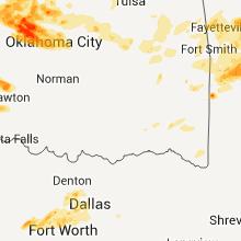
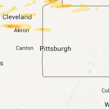
Hail Map for Monday, May 23, 2011

Number of Impacted Households on 5/23/2011
0
Impacted by 1" or Larger Hail
0
Impacted by 1.75" or Larger Hail
0
Impacted by 2.5" or Larger Hail
Square Miles of Populated Area Impacted on 5/23/2011
0
Impacted by 1" or Larger Hail
0
Impacted by 1.75" or Larger Hail
0
Impacted by 2.5" or Larger Hail


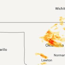

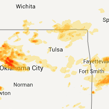


Cities Most Affected by Hail Storms of 5/23/2011
| Hail Size | Demographics of Zip Codes Affected | ||||||
|---|---|---|---|---|---|---|---|
| City | Count | Average | Largest | Pop Density | House Value | Income | Age |
| Okarche, OK | 6 | 2.27 | 3.10 | 7 | $82k | $39.0k | 42.4 |
| Kingfisher, OK | 4 | 1.88 | 2.00 | 25 | $73k | $37.7k | 39.0 |
| Mountain View, OK | 3 | 2.42 | 3.01 | 4 | $33k | $24.9k | 46.4 |
| Oklahoma City, OK | 3 | 2.08 | 2.50 | 2957 | $75k | $22.0k | 29.6 |
| Gotebo, OK | 2 | 2.63 | 3.51 | 2 | $22k | $28.8k | 44.4 |
| Mocksville, NC | 2 | 2.13 | 2.50 | 132 | $97k | $36.8k | 40.5 |
| Yukon, OK | 2 | 2.00 | 2.00 | 529 | $87k | $49.1k | 35.3 |
| Braman, OK | 2 | 1.88 | 2.00 | 3 | $33k | $32.1k | 49.2 |
| North Wilkesboro, NC | 2 | 1.75 | 1.75 | 205 | $85k | $31.5k | 41.4 |
| Sentinel, OK | 2 | 1.75 | 1.75 | 2 | $31k | $30.1k | 39.6 |
| Meno, OK | 2 | 1.75 | 1.75 | 6 | $55k | $35.5k | 40.8 |
| North Ridgeville, OH | 2 | 1.75 | 1.75 | 1332 | $130k | $54.2k | 40.7 |
| Carnegie, OK | 2 | 1.75 | 1.75 | 8 | $42k | $24.6k | 41.2 |
| Healdton, OK | 2 | 1.75 | 1.75 | 37 | $33k | $24.8k | 38.5 |
| Apache, OK | 1 | 3.20 | 3.20 | 11 | $49k | $28.1k | 41.0 |
| Helena, OK | 1 | 3.00 | 3.00 | 3 | $35k | $34.0k | 44.9 |
| Wellington, KS | 1 | 2.75 | 2.75 | 42 | $60k | $36.4k | 38.8 |
| Electra, TX | 1 | 2.75 | 2.75 | 11 | $30k | $26.5k | 41.9 |
| Ringwood, OK | 1 | 2.50 | 2.50 | 10 | $50k | $30.6k | 38.6 |
| Greenfield, OK | 1 | 2.00 | 2.00 | 4 | $30k | $22.5k | 55.4 |
| Rosebud, MO | 1 | 2.00 | 2.00 | 27 | $68k | $36.3k | 43.0 |
| Flatgap, KY | 1 | 2.00 | 2.00 | 44 | $48k | $23.4k | 39.8 |
| Indiahoma, OK | 1 | 1.75 | 1.75 | 11 | $56k | $33.4k | 39.8 |
| Garysburg, NC | 1 | 1.75 | 1.75 | 27 | $53k | $23.5k | 43.8 |
| Roaring River, NC | 1 | 1.75 | 1.75 | 64 | $74k | $30.9k | 41.5 |
| Rocky, OK | 1 | 1.75 | 1.75 | 5 | $30k | $31.6k | 42.5 |
| Imperial, NE | 1 | 1.75 | 1.75 | 2 | $67k | $34.4k | 41.3 |
| Hamptonville, NC | 1 | 1.75 | 1.75 | 86 | $85k | $37.2k | 39.4 |
| Salyersville, KY | 1 | 1.75 | 1.75 | 32 | $57k | $20.1k | 39.1 |
| Newton Falls, OH | 1 | 1.75 | 1.75 | 258 | $88k | $39.2k | 42.9 |
| Union Grove, NC | 1 | 1.75 | 1.75 | 42 | $93k | $34.5k | 44.4 |
| Huntingburg, IN | 1 | 1.75 | 1.75 | 120 | $82k | $39.1k | 38.8 |
| Vienna, OH | 1 | 1.75 | 1.75 | 159 | $98k | $45.6k | 48.0 |
| Corydon, IN | 1 | 1.75 | 1.75 | 101 | $99k | $42.4k | 39.7 |
| Enid, OK | 1 | 1.75 | 1.75 | 170 | $39k | $26.6k | 33.1 |
| Fairview, OK | 1 | 1.75 | 1.75 | 10 | $52k | $30.5k | 44.8 |
| Utica, KS | 1 | 1.75 | 1.75 | 1 | $32k | $30.0k | 51.1 |
| North Olmsted, OH | 1 | 1.75 | 1.75 | 2828 | $142k | $52.5k | 43.4 |
| Wilkesboro, NC | 1 | 1.75 | 1.75 | 191 | $118k | $39.6k | 43.6 |
| Olney, IL | 1 | 1.75 | 1.75 | 79 | $65k | $31.0k | 42.3 |
| Cleveland, OH | 1 | 1.75 | 1.75 | 3030 | $127k | $42.7k | 45.0 |
| Atwood, KS | 1 | 1.75 | 1.75 | 4 | $49k | $32.6k | 50.7 |
| Winona, KS | 1 | 1.75 | 1.75 | 0 | $32k | $33.1k | 44.1 |
| Greensboro, MD | 1 | 1.75 | 1.75 | 126 | $100k | $39.6k | 35.9 |
Hail and Wind Damage Spotted on 5/23/2011
Filter by Report Type:Hail ReportsWind Reports
States Impacted
Kansas, Oklahoma, Kentucky, Missouri, Texas, Michigan, Illinois, Arkansas, Colorado, North Carolina, Indiana, Ohio, Pennsylvania, Maryland, Tennessee, Florida, Virginia, Nebraska, New York, New Jersey, West VirginiaKansas
| Local Time | Report Details |
|---|---|
| 12:11 PM UTC | Storm damage reported in montgomery county KS, 40.7 miles S of Chanute, KS |
| 12:25 PM UTC | Storm damage reported in labette county KS, 25.6 miles SSE of Chanute, KS |
| 12:31 PM UTC | Quarter sized hail reported near Caney, KS, 53.3 miles SSW of Chanute, KS |
| 7:48 AM CDT | Storm damage reported in labette county KS, 45.3 miles SSE of Chanute, KS |
| 1:12 PM UTC | Quarter sized hail reported near Chetopa, KS, 51.7 miles SSE of Chanute, KS, reported at sw 90th street and highway 166. |
| 9:33 PM UTC | Baseball sized hail reported near Wellington, KS, 36.5 miles S of Wichita, KS |
| 9:42 PM UTC | Quarter sized hail reported near Wellington, KS, 29.7 miles S of Wichita, KS |
| 9:46 PM UTC | Half Dollar sized hail reported near Wellington, KS, 29.2 miles S of Wichita, KS, report was located at highway 160 and interstate 35. |
| 11:22 PM UTC | Quarter sized hail reported near Atwood, KS, 34.7 miles N of Colby, KS |
| 11:39 PM UTC | Golf Ball sized hail reported near Atwood, KS, 39.5 miles N of Colby, KS |
| 12:16 AM UTC | Golf Ball sized hail reported near Winona, KS, 20.3 miles SSW of Colby, KS |
| 8:55 AM UTC | Quarter sized hail reported near Scott City, KS, 42.6 miles N of Garden City, KS |
| 9:46 AM UTC | Quarter sized hail reported near Healy, KS, 47.2 miles NNE of Garden City, KS |
| 10:30 AM UTC | Quarter sized hail reported near Dighton, KS, 51.5 miles NNE of Garden City, KS |
| 10:40 AM UTC | Golf Ball sized hail reported near Utica, KS, 52.8 miles NE of Garden City, KS |
| 11:45 AM UTC | Quarter sized hail reported near Bazine, KS, 32.7 miles SW of Hays, KS, the hail broke holes in fiberglass roof panels on a shed. |
| 11:46 AM UTC | Quarter sized hail reported near Brownell, KS, 30.4 miles SW of Hays, KS, the ground was white with hail stones varying from the size of peas to the size of quarters. |
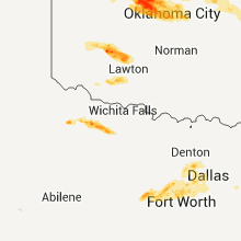
Oklahoma
| Local Time | Report Details |
|---|---|
| 12:30 PM UTC | Tree blown down in nowata county OK, 49.5 miles SSW of Chanute, KS |
| 1:10 PM UTC | Quarter sized hail reported near Welch, OK, 55.1 miles S of Chanute, KS |
| 1:15 PM UTC | Storm damage reported in nowata county OK, 52.1 miles NNE of Tulsa, OK |
| 1:30 PM UTC | Quarter sized hail reported near Welch, OK, 57.7 miles SSE of Chanute, KS |
| 6:56 PM UTC | Quarter sized hail reported near Quapaw, OK, 62.3 miles SE of Chanute, KS, mostly dime sized but a few as big as a quarter. |
| 8:55 PM UTC | Quarter sized hail reported near Fairview, OK, 53.2 miles ESE of Woodward, OK |
| 8:55 PM UTC | Quarter sized hail reported near Seiling, OK, 40.9 miles SE of Woodward, OK |
| 9:05 PM UTC | Quarter sized hail reported near Oakwood, OK, 53.7 miles SE of Woodward, OK |
| 9:05 PM UTC | Quarter sized hail reported near Seiling, OK, 40.9 miles SE of Woodward, OK |
| 4:20 PM CDT | Tennis Ball sized hail reported near Ringwood, OK, 64 miles E of Woodward, OK |
| 9:24 PM UTC | Quarter sized hail reported near Sentinel, OK, 79.9 miles NE of Childress, TX |
| 9:24 PM UTC | Golf Ball sized hail reported near Meno, OK, 69 miles E of Woodward, OK, report via off duty wfo hastings employee. |
| 4:24 PM CDT | Golf Ball sized hail reported near Meno, OK, 68.5 miles E of Woodward, OK |
| 9:29 PM UTC | Tea Cup sized hail reported near Helena, OK, 64.6 miles E of Woodward, OK, report relayed via off duty wfo hastings employee. |
| 9:33 PM UTC | Golf Ball sized hail reported near Sentinel, OK, 77.7 miles NE of Childress, TX |
| 9:33 PM UTC | Golf Ball sized hail reported near Rocky, OK, 81.2 miles NE of Childress, TX |
| 9:35 PM UTC | Golf Ball sized hail reported near Braman, OK, 52.9 miles S of Wichita, KS |
| 9:37 PM UTC | Hen Egg sized hail reported near Braman, OK, 53.1 miles S of Wichita, KS |
| 9:45 PM UTC | Golf Ball sized hail reported near Sentinel, OK, 78.2 miles NE of Childress, TX |
| 9:46 PM UTC | Quarter sized hail reported near Elmer, OK, 49.3 miles E of Childress, TX |
| 9:54 PM UTC | Golf Ball sized hail reported near Enid, OK, 67.1 miles NNW of Oklahoma City, OK |
| 10:01 PM UTC | Storm damage reported in kay county OK, 70.2 miles S of Wichita, KS |
| 10:10 PM UTC | Quarter sized hail reported near Tipton, OK, 54.8 miles NW of Wichita Falls, TX |
| 10:13 PM UTC | Quarter sized hail reported near Mountain View, OK, 80.6 miles WSW of Oklahoma City, OK |
| 10:18 PM UTC | Golf Ball sized hail reported near Gotebo, OK, 81.2 miles WSW of Oklahoma City, OK |
| 10:18 PM UTC | Tennis Ball sized hail reported near Mountain View, OK, 80.6 miles WSW of Oklahoma City, OK |
| 10:19 PM UTC | Quarter sized hail reported near Enid, OK, 67.1 miles NNW of Oklahoma City, OK |
| 10:21 PM UTC | Half Dollar sized hail reported near Medford, OK, 54.3 miles SSW of Wichita, KS |
| 10:24 PM UTC | Tea Cup sized hail reported near Gotebo, OK, 80.8 miles NNW of Wichita Falls, TX |
| 10:29 PM UTC | Quarter sized hail reported near Frederick, OK, 47.4 miles NW of Wichita Falls, TX, at manitou |
| 10:40 PM UTC | Ping Pong Ball sized hail reported near Frederick, OK, 47.4 miles NW of Wichita Falls, TX, at manitou |
| 10:45 PM UTC | Golf Ball sized hail reported near Mountain View, OK, 74.1 miles WSW of Oklahoma City, OK |
| 10:45 PM UTC | Hen Egg sized hail reported near Greenfield, OK, 51.6 miles WNW of Oklahoma City, OK |
| 10:52 PM UTC | Tea Cup sized hail reported near Mountain View, OK, 80.6 miles WSW of Oklahoma City, OK |
| 11:00 PM UTC | Quarter sized hail reported near Carnegie, OK, 66.2 miles WSW of Oklahoma City, OK |
| 11:07 PM UTC | Quarter sized hail reported near Okarche, OK, 38.2 miles WNW of Oklahoma City, OK |
| 11:11 PM UTC | Quarter sized hail reported near Kingfisher, OK, 38.7 miles NW of Oklahoma City, OK |
| 11:12 PM UTC | Golf Ball sized hail reported near Okarche, OK, 38.2 miles WNW of Oklahoma City, OK |
| 11:13 PM UTC | Tennis Ball sized hail reported near Okarche, OK, 31.5 miles WNW of Oklahoma City, OK |
| 11:23 PM UTC | Golf Ball sized hail reported near Indiahoma, OK, 51.1 miles NNW of Wichita Falls, TX |
| 11:26 PM UTC | Golf Ball sized hail reported near Carnegie, OK, 66.2 miles WSW of Oklahoma City, OK |
| 11:30 PM UTC | Quarter sized hail reported near Carnegie, OK, 68.2 miles WSW of Oklahoma City, OK |
| 11:30 PM UTC | Tea Cup sized hail reported near Apache, OK, 64.5 miles SW of Oklahoma City, OK |
| 11:31 PM UTC | Golf Ball sized hail reported near Okarche, OK, 39.2 miles WNW of Oklahoma City, OK |
| 11:44 PM UTC | Golf Ball sized hail reported near Carnegie, OK, 67.7 miles N of Wichita Falls, TX |
| 11:58 PM UTC | Golf Ball sized hail reported near Fairview, OK, 52.5 miles ESE of Woodward, OK |
| 12:02 AM UTC | Golf Ball sized hail reported near Healdton, OK, 61 miles ENE of Wichita Falls, TX |
| 12:07 AM UTC | Storm damage reported in logan county OK, 38.7 miles N of Oklahoma City, OK |
| 12:10 AM UTC | Golf Ball sized hail reported near Healdton, OK, 59.7 miles ENE of Wichita Falls, TX |
| 12:20 AM UTC | Reports of several trees blown down in the vicinity of kenwoo in delaware county OK, 57.9 miles E of Tulsa, OK |
| 12:23 AM UTC | Golf Ball sized hail reported near , , 36.4 miles N of Oklahoma City, OK |
| 12:30 AM UTC | Quarter sized hail reported near Okeene, OK, 61.9 miles NW of Oklahoma City, OK |
| 12:35 AM UTC | Half Dollar sized hail reported near Okeene, OK, 59.6 miles NW of Oklahoma City, OK |
| 1:09 AM UTC | Quarter sized hail reported near Kingfisher, OK, 37.5 miles NW of Oklahoma City, OK |
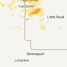
| 1:12 AM UTC | Several trees and a few power lines blown down in cherokee county OK, 48.1 miles NW of Fort Smith, AR |
| 1:17 AM UTC | Golf Ball sized hail reported near Kingfisher, OK, 35.3 miles NW of Oklahoma City, OK |
| 1:22 AM UTC | Golf Ball sized hail reported near Kingfisher, OK, 34.2 miles NW of Oklahoma City, OK |
| 1:24 AM UTC | Storm damage reported in adair county OK, 37.4 miles NNW of Fort Smith, AR |
| 8:25 PM CDT | Hen Egg sized hail reported near Kingfisher, OK, 32.2 miles NNW of Oklahoma City, OK |
| 1:31 AM UTC | Hen Egg sized hail reported near Kingfisher, OK, 33.5 miles NW of Oklahoma City, OK |
| 1:46 AM UTC | Storm damage reported in payne county OK, 52.4 miles NNE of Oklahoma City, OK |
| 2:25 AM UTC | Numerous power lines down in le flore county OK, 24.8 miles WSW of Fort Smith, AR |
| 2:28 AM UTC | Power lines down in le flore county OK, 2.6 miles SSW of Fort Smith, AR |
| 2:33 AM UTC | Large tree down...multiple power lines down...some property damag in le flore county OK, 2.6 miles SSW of Fort Smith, AR |
| 2:34 AM UTC | Storm damage reported in le flore county OK, 20.4 miles SW of Fort Smith, AR |
| 2:40 AM UTC | Ping Pong Ball sized hail reported near Okarche, OK, 31.4 miles NW of Oklahoma City, OK |
| 2:43 AM UTC | Golf Ball sized hail reported near Okarche, OK, 31.4 miles NW of Oklahoma City, OK |
| 2:44 AM UTC | Baseball sized hail reported near Okarche, OK, 31.4 miles NW of Oklahoma City, OK |
| 9:44 PM CDT | Tea Cup sized hail reported near Okarche, OK, 31.8 miles NW of Oklahoma City, OK |
| 3:20 AM UTC | Hen Egg sized hail reported near Oklahoma City, OK, 14.3 miles NW of Oklahoma City, OK |
| 3:27 AM UTC | Hen Egg sized hail reported near Oklahoma City, OK, 13 miles NW of Oklahoma City, OK |
| 3:31 AM UTC | Half Dollar sized hail reported near Oklahoma City, OK, 0.6 miles ESE of Oklahoma City, OK, portland and 166th |
| 3:45 AM UTC | Hen Egg sized hail reported near Oklahoma City, OK, 0.6 miles ESE of Oklahoma City, OK, at memorial and western ave |
| 10:45 PM CDT | Tennis Ball sized hail reported near Oklahoma City, OK, 10.4 miles NW of Oklahoma City, OK |
| 3:55 AM UTC | Quarter sized hail reported near Edmond, OK, 13.5 miles NNE of Oklahoma City, OK |
| 3:59 AM UTC | Quarter sized hail reported near Oklahoma City, OK, 0.6 miles ESE of Oklahoma City, OK, at memorial and coltrane roads |
| 4:05 AM UTC | Golf Ball sized hail reported near Oklahoma City, OK, 0.6 miles ESE of Oklahoma City, OK, i-35 exit 136 near turner turnpike exit |
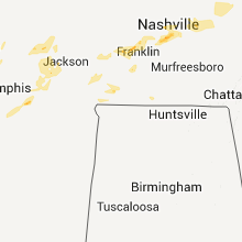
Kentucky
| Local Time | Report Details |
|---|---|
| 1:01 PM UTC | Tree down near south for in breathitt county KY, 36.7 miles ESE of Irvine, KY |
| 1:07 PM UTC | Tree down on hwy 30 es in breathitt county KY, 41.5 miles E of Irvine, KY |
| 9:14 AM EDT | Golf Ball sized hail reported near Salyersville, KY, 42.5 miles E of Irvine, KY |
| 1:14 PM UTC | Trees down in foraker along highway 3 in magoffin county KY, 45.8 miles E of Irvine, KY |
| 1:22 PM UTC | Trees down between highway 460 and 4 in pike county KY, 63.1 miles N of Bristol, TN |
| 1:28 PM UTC | High winds moved a triaxle rv trailer approximately 2 to 3 feet. winds also ripped awning apart. limbs approximately 2 inches in diameter were broken off of trees and a in knox county KY, 57.5 miles S of Irvine, KY |
| 10:18 PM UTC | 70 mile an hour wind gusts in downtown louisville in jefferson county KY, 18.1 miles N of Louisville, KY |
| 10:24 PM UTC | Several trees down along river road in jefferson county KY, 16.1 miles N of Louisville, KY |
| 10:26 PM UTC | Storm damage reported in oldham county KY, 33.1 miles NE of Louisville, KY |
| 10:47 PM UTC | Large trees down along with 65 mile an hour wind gusts in henry county KY, 46.5 miles NE of Louisville, KY |
| 10:51 PM UTC | Trees down in shelby county KY, 31.3 miles ENE of Louisville, KY |
| 11:14 PM UTC | A large tree limb was downed on a hous in kenton county KY, 3.1 miles SW of Cincinnati, OH |
| 11:17 PM UTC | Barn damaged in owen county KY, 43.1 miles SSW of Cincinnati, OH |
| 11:20 PM UTC | Trees dow in boone county KY, 13 miles WSW of Cincinnati, OH |
| 11:27 PM UTC | Storm damage reported in kenton county KY, 5.6 miles SW of Cincinnati, OH |
| 11:40 PM UTC | Trees down in harrison county KY, 39.9 miles SSE of Cincinnati, OH |
| 11:50 PM UTC | Trees down in harrison county KY, 41 miles S of Cincinnati, OH |
| 11:55 PM UTC | Quarter sized hail reported near Cadiz, KY, 50.9 miles NE of Mc Kenzie, TN |
| 12:10 AM UTC | Several downed trees blocking roads across the city in scott county KY, 46.7 miles NW of Irvine, KY |
| 12:28 AM UTC | Several trees down across lexington including two near brian station and johnston road in fayette county KY, 35.4 miles NW of Irvine, KY |
| 12:30 AM UTC | Tree down in lewis county KY, 62.5 miles SE of Cincinnati, OH |
| 12:30 AM UTC | Tree down in lewis county KY, 56.2 miles NNE of Irvine, KY |
| 1:05 AM UTC | Quarter sized hail reported near Brownsville, KY, 60.3 miles SW of Louisville, KY |
| 1:07 AM UTC | Two trees down in the load area...exact roads unknown in greenup county KY, 73.5 miles WNW of Charleston, WV |
| 1:22 AM UTC | Trees down between highway 460 and 4 in magoffin county KY, 50.6 miles E of Irvine, KY |
| 1:32 AM UTC | Quarter sized hail reported near Flatgap, KY, 60 miles ENE of Irvine, KY, quarter sized hail near junction of route 172 and patterson creek road |
| 9:33 PM EDT | Hen Egg sized hail reported near Flatgap, KY, 60.9 miles ENE of Irvine, KY |
| 1:41 AM UTC | Lines down in lowmansville in lawrence county KY, 66.7 miles WSW of Charleston, WV |
| 4:18 AM UTC | Trees down along hwy 1277. time est from rada in whitley county KY, 56.7 miles SSW of Irvine, KY |
| 4:18 AM UTC | Trees down along hwy 699 near mm10/11. time est from rada in leslie county KY, 60.1 miles SE of Irvine, KY |
| 11:23 AM UTC | Tree blown on to a power line on highway 44 in cumberland county KY, 86.3 miles ENE of Nashville, TN |
| 11:39 AM UTC | Trees down in albany. at 0745 am edt...a 51mph gust was measured near alban in clinton county KY, 84.6 miles NW of Knoxville, TN |
| 11:39 AM UTC | Trees down in alban in clinton county KY, 84.6 miles NW of Knoxville, TN |
| 11:45 AM UTC | Trees were downed near dale hollow lak in cumberland county KY, 89.1 miles ENE of Nashville, TN |
| 11:54 AM UTC | Trees...power lines...and limbs were blown down in the towns of zula and number on in wayne county KY, 81.3 miles NW of Knoxville, TN |
| 11:54 AM UTC | Trees...power lines...and limbs were blown down in zul in wayne county KY, 81.3 miles NW of Knoxville, TN |
Missouri
| Local Time | Report Details |
|---|---|
| 1:48 PM UTC | Quarter sized hail reported near Joplin, MO, 63.9 miles SE of Chanute, KS |
| 1:56 PM UTC | 60 to 70 mph wind gust and pea hail relayed by spotter in vernon county MO, 57.6 miles NW of Springfield, MO |
| 2:35 PM UTC | Storm damage reported in hickory county MO, 46 miles N of Springfield, MO |
| 3:43 PM UTC | Three foot diameter tree down in eldo in miller county MO, 43.6 miles SSW of Columbia, MO |
| 3:55 PM UTC | Tree down across state route e just north of the route e/route a intersectio in phelps county MO, 32.7 miles NW of Salem, MO |
| 4:22 PM UTC | Quarter sized hail reported near St James, MO, 26.1 miles N of Salem, MO, dime to quarter sized hail reported near state route b/county road 1060 intersection. |
| 4:30 PM UTC | Hen Egg sized hail reported near Rosebud, MO, 56.1 miles N of Salem, MO, three foot diameter tree uprooted near residence. many other trees uprooted and limbs broken off near observer location. |
| 4:30 PM UTC | Several trees uprooted. one tree was 2 feet in diamete in gasconade county MO, 52.5 miles N of Salem, MO |
| 4:30 PM UTC | Three foot diameter tree uprooted near residence. many other trees uprooted and limbs broken off near observer locatio in gasconade county MO, 56.1 miles N of Salem, MO |
| 4:39 PM UTC | Tin sheets off of roofs and limbs down everywhere in tow in gasconade county MO, 46 miles N of Salem, MO |
| 4:42 PM UTC | Pea-size hail fell with this storm as well. no damage visible in the immediate are in gasconade county MO, 49.2 miles N of Salem, MO |
| 4:50 PM UTC | Power out in the berger area along with pea size hail in franklin county MO, 58.8 miles ESE of Columbia, MO |
| 4:55 PM UTC | A few shingles blown off of some roof in franklin county MO, 53.8 miles NNE of Salem, MO |
| 4:59 PM UTC | 6 to 10 inch diameter limbs down...pea size hail in franklin county MO, 45.6 miles WSW of Saint Louis, MO |
| 5:00 PM UTC | Trees and power lines down throughout the county... including along holt road in the south end... hwy 100 in the north end... and live lines down in owensvill in gasconade county MO, 49.2 miles N of Salem, MO |
| 5:00 PM UTC | Roof off a mobile home. late report probably took place around noo in warren county MO, 46.5 miles WNW of Saint Louis, MO |
| 5:02 PM UTC | Trees down along independence street in downtown union... relayed by amateur radi in franklin county MO, 45.6 miles WSW of Saint Louis, MO |
| 5:04 PM UTC | Small tree limbs down. estimated winds of 40 to 50 mp in franklin county MO, 44.2 miles W of Saint Louis, MO |
| 5:05 PM UTC | Storm damage reported in warren county MO, 44 miles W of Saint Louis, MO |
| 5:06 PM UTC | Hall brothers lumber has roofing blown of in franklin county MO, 45.6 miles WSW of Saint Louis, MO |
| 5:11 PM UTC | 55 to 60 mph winds estimated with 9-inch diameter trees bent over at a 90 degree angle. winds lasted about 30 second in st. charles county MO, 34.4 miles WNW of Saint Louis, MO |
| 5:12 PM UTC | 50 to 60 mph gust at wentzville parkway at west meye in st. charles county MO, 37.8 miles WNW of Saint Louis, MO |
| 5:16 PM UTC | Numerous finger to thumb size diameter branches dow in st. charles county MO, 29.5 miles WNW of Saint Louis, MO |
| 5:22 PM UTC | Numerous trees and at least one power line down in tow in franklin county MO, 45.6 miles WSW of Saint Louis, MO |
| 5:23 PM UTC | Report is from the st. albans area...trees up to 1 foot in diameter snapped in franklin county MO, 31.1 miles W of Saint Louis, MO |
| 5:27 PM UTC | 3 9-18 inch trees down at meadowbrook country club near clayton and kerrs mill roa in st. louis county MO, 20.6 miles W of Saint Louis, MO |
| 5:29 PM UTC | Large limbs and trees down at 141 and big bend. one lane of southbound 141 blocke in st. louis county MO, 17 miles W of Saint Louis, MO |
| 5:30 PM UTC | 12 inch branches down in st. louis county MO, 7.1 miles W of Saint Louis, MO |
| 5:31 PM UTC | From the towe in st. louis county MO, 13 miles NW of Saint Louis, MO |
| 5:32 PM UTC | Quarter sized hail reported near Valley Park, MO, 16.1 miles WSW of Saint Louis, MO, 1 mile west of intersection of big bend and 141. |
| 5:35 PM UTC | 30 inch tree blocking road at hillsdale and normandy roa in st. louis county MO, 7.4 miles NW of Saint Louis, MO |
| 5:35 PM UTC | 20 inch diameter tree down blocking traffic at arsenal and branno in st. louis city county MO, 2.3 miles WNW of Saint Louis, MO |
| 5:40 PM UTC | Large tree uprooted onto home in tower grov in st. louis city county MO, 2.3 miles WNW of Saint Louis, MO |
| 5:44 PM UTC | Three-inch tree down at 367 and parker intersection in st. louis county MO, 12.3 miles NNW of Saint Louis, MO |
| 5:45 PM UTC | Numerous trees... branches... and power outages throughout the city from ksdk channel in st. louis city county MO, 2.3 miles WNW of Saint Louis, MO |
| 5:45 PM UTC | 3-inch diameter trees down at intersection of des peres road and wild deer road. 8-inch limb blocking warson woods drive near timberlake driv in st. louis county MO, 10.4 miles W of Saint Louis, MO |
| 5:48 PM UTC | Several 4-6 inch branches down in the area of st. louis university hospita in st. louis city county MO, 2.3 miles WNW of Saint Louis, MO |
| 5:50 PM UTC | Shingles and debris blown about along with a pushed in garage doo in lincoln county MO, 38.9 miles NW of Saint Louis, MO |
| 6:12 PM UTC | Multiple large trees and power lines down with almost every road closed at st. albans. smaller trees down in gray summit. estimated wind gust at 65 mp in franklin county MO, 34.9 miles WSW of Saint Louis, MO |
| 6:41 PM UTC | Metal carport blown onto road in howell county MO, 77.7 miles SSW of Salem, MO |
| 7:12 PM UTC | Quarter sized hail reported near Redford, MO, 41.2 miles ESE of Salem, MO, quarter-sized hail |
| 8:18 PM UTC | Large tree across highway m in madison county MO, 37 miles WNW of Cape Girardeau, MO |
| 9:00 PM UTC | From new wells to the perry county line...numerous trees down...3 to 4 barns with roofs blown off...shingles off a few houses in cape girardeau county MO, 18.2 miles NNW of Cape Girardeau, MO |
| 9:25 PM UTC | Billboards and signs blown down between exits 61 and 67 on interstate 55 between sikeston and matthew in scott county MO, 29.2 miles S of Cape Girardeau, MO |
| 1:01 AM UTC | Quarter sized hail reported near Norborne, MO, 50.3 miles ENE of Kansas City, MO |
Texas
| Local Time | Report Details |
|---|---|
| 10:16 AM CDT | Quarter sized hail reported near Weatherford, TX, 46.9 miles W of Dallas, TX, north of white settlement rd. |
| 10:19 AM CDT | Quarter sized hail reported near Fort Worth, TX, 38.7 miles W of Dallas, TX |
| 3:25 PM UTC | Quarter sized hail reported near Sansom Park, TX, 35.2 miles W of Dallas, TX, quarter size hail fell for 10 minutes starting at 1015 am at jacksboro highway and confederate parkway |
| 10:25 AM CDT | Quarter sized hail reported near Fort Worth, TX, 31.8 miles W of Dallas, TX, berry st. and interstate 35w |
| 10:32 AM CDT | Quarter sized hail reported near Fort Worth, TX, 34.1 miles W of Dallas, TX, nickel to quarter size hail 2 miles se of river oaks |
| 3:34 PM UTC | Quarter sized hail reported near Blue Mound, TX, 32.1 miles W of Dallas, TX, intersection of fossil creek blvd and sandshell dr. |
| 3:39 PM UTC | Quarter sized hail reported near Fort Worth, TX, 31.8 miles W of Dallas, TX |
| 11:40 AM CDT | Quarter sized hail reported near Shady Shores, TX, 29.9 miles NNW of Dallas, TX, shady shores and interstate 35 |
| 10:43 PM UTC | Tennis Ball sized hail reported near , , 35 miles W of Wichita Falls, TX |
| 10:45 PM UTC | Baseball sized hail reported near Electra, TX, 33 miles WSW of Wichita Falls, TX |
| 12:08 AM UTC | Quarter sized hail reported near Holliday, TX, 22.3 miles SSW of Wichita Falls, TX |
Michigan
| Local Time | Report Details |
|---|---|
| 4:56 PM UTC | Six inch diameter limbs down and several trees in midland county MI, 50.6 miles NNW of Flint, MI |
| 7:40 PM UTC | Numerous four inch diameter limbs down in washtenaw county MI, 54.3 miles S of Flint, MI |
| 7:54 PM UTC | 30 inch diameter tree down in wayne county MI, 48.4 miles SSE of Flint, MI |
| 7:56 PM UTC | Powerlines and 3-4 inch diameter limbs down in wayne county MI, 49.5 miles SSE of Flint, MI |
| 7:56 PM UTC | Several six inch diameter limbs down in wayne county MI, 50.1 miles SSE of Flint, MI |
| 8:07 PM UTC | Large tree down in wayne county MI, 52.9 miles SE of Flint, MI |
| 8:15 PM UTC | Tree limbs down in macomb county MI, 51.8 miles SE of Flint, MI |
| 8:15 PM UTC | Large tree down on powerlines in macomb county MI, 52.9 miles SE of Flint, MI |
| 8:15 PM UTC | Numerous large limbs down in macomb county MI, 52.5 miles SE of Flint, MI |
| 8:20 PM UTC | Trees down in macomb county MI, 54.1 miles SE of Flint, MI |
| 9:17 PM UTC | 3-4 inch diameter limbs down. pea size hail also reporte in washtenaw county MI, 59.8 miles SSW of Flint, MI |
| 9:50 PM UTC | Three inch diameter limbs down in wayne county MI, 51.7 miles SSE of Flint, MI |
| 9:58 PM UTC | Eight inch diameter limb down and damage to a church in washtenaw county MI, 54.7 miles S of Flint, MI |
| 10:19 PM UTC | Ping Pong Ball sized hail reported near Adrian, MI, 73.4 miles SSW of Flint, MI |
| 10:27 PM UTC | Trees down in lenawee county MI, 72.4 miles S of Flint, MI |
| 10:30 PM UTC | Trees down in lenawee county MI, 70.8 miles S of Flint, MI |
| 10:30 PM UTC | Trees down in lenawee county MI, 68.1 miles S of Flint, MI |
| 12:04 AM UTC | Quarter sized hail reported near Exeter, MI, 65.6 miles S of Flint, MI |
| 12:17 AM UTC | Numerous trees down in the community in wayne county MI, 66.4 miles SSE of Flint, MI |
Illinois
| Local Time | Report Details |
|---|---|
| 5:48 PM UTC | Relayed via the tower chief in madison county IL, 21.1 miles NNE of Saint Louis, MO |
| 5:51 PM UTC | 2 to 3 inch diameter trees at numerous locations around glen carbo in madison county IL, 15.4 miles NE of Saint Louis, MO |
| 5:53 PM UTC | Chimney damaged near the intersection of hwy 203 and 20th st in madison county IL, 6.8 miles NNE of Saint Louis, MO |
| 5:55 PM UTC | 3-inch tree limbs blown down with power out in parts of wood rive in madison county IL, 17.3 miles NNE of Saint Louis, MO |
| 6:02 PM UTC | 12 inch diameter tree down on clay street in troy... i in madison county IL, 18.2 miles ENE of Saint Louis, MO |
| 6:26 PM UTC | 30-inch tree snapped 6 feet off the groun in bond county IL, 46.8 miles ENE of Saint Louis, MO |
| 6:30 PM UTC | Quarter sized hail reported near Salem, IL, 67.6 miles E of Saint Louis, MO |
| 6:54 PM UTC | Six inch diameter branches down in marion county IL, 58.4 miles E of Saint Louis, MO |
| 7:04 PM UTC | Powerlines down in effingham county IL, 41.2 miles SSW of Mattoon, IL |
| 7:10 PM UTC | Large tree limbs down. time estimate in effingham county IL, 39.1 miles SSW of Mattoon, IL |
| 7:24 PM UTC | Storm damage reported in clay county IL, 56.9 miles S of Mattoon, IL |
| 7:24 PM UTC | Tree limbs down in clay county IL, 54.9 miles S of Mattoon, IL |
| 7:25 PM UTC | Tree limbs up to 6 inches in diameter down...along with vinyl fencing and powerlines down on the northeast side of flora. time estimated. relayed by weh in clay county IL, 55.5 miles S of Mattoon, IL |
| 7:28 PM UTC | Storm damage reported in effingham county IL, 26 miles SSW of Mattoon, IL |
| 7:30 PM UTC | Tree down across main street. time estimate in clay county IL, 54.6 miles S of Mattoon, IL |
| 7:30 PM UTC | Tree down and powerlines down in jasper county IL, 32.1 miles SSE of Mattoon, IL |
| 7:34 PM UTC | Trees blown down in jasper county IL, 31.4 miles SE of Mattoon, IL |
| 7:41 PM UTC | Roof off building at 23rd and washington avenue... multiple reports of up to 36-inch diameter trees down throughout cit in madison county IL, 6.8 miles NNE of Saint Louis, MO |
| 7:47 PM UTC | Tree limbs and powerlines down across town in richland county IL, 54.1 miles SSE of Mattoon, IL |
| 7:47 PM UTC | Golf Ball sized hail reported near Olney, IL, 52.7 miles SSE of Mattoon, IL, on the north side of town |
| 7:53 PM UTC | Powerlines down. winds estimated at 60 mp in crawford county IL, 38.3 miles SE of Mattoon, IL |
| 7:58 PM UTC | Tree down on a house. time estimate in clark county IL, 24.2 miles ESE of Mattoon, IL |
| 8:15 PM UTC | Storm damage reported in lawrence county IL, 54.9 miles N of Evansville, IN |
| 8:18 PM UTC | Tree limbs coming down in wabash county IL, 30.7 miles NNW of Evansville, IN |
| 8:21 PM UTC | Utility pole blown down in clark county IL, 37.1 miles E of Mattoon, IL |
| 8:21 PM UTC | Quarter sized hail reported near Browns, IL, 35.9 miles NW of Evansville, IN, nickel to quarter size hail |
| 8:39 PM UTC | Power pole snapped in vermilion county IL, 46.3 miles NE of Mattoon, IL |
| 8:39 PM UTC | Three foot diameter tree blown down in vermilion county IL, 46.3 miles NE of Mattoon, IL |
| 8:40 PM UTC | Storm damage reported in vermilion county IL, 51.7 miles NE of Mattoon, IL |
| 10:22 PM UTC | Late report...time correccted. em reported damage countywide. several barns damaged with two homes moved off of foundation...numerous trees snapped or down. 2 main area in gallatin county IL, 39.9 miles WSW of Evansville, IN |
| 10:25 PM UTC | Several power poles down in gallatin county IL, 39.9 miles WSW of Evansville, IN |
| 10:30 PM UTC | Late report...time estimated. em reported damage countywide. several barns damaged with numerous trees snapped or down. 2 main areas...near the community of ridgway and in gallatin county IL, 39.9 miles WSW of Evansville, IN |
Arkansas
| Local Time | Report Details |
|---|---|
| 5:55 PM UTC | Quarter sized hail reported near Gassville, AR, 78 miles SE of Springfield, MO |
| 6:56 PM UTC | Large trees were uproote in fulton county AR, 88.9 miles S of Salem, MO |
| 7:04 PM UTC | Quarter sized hail reported near Ash Flat, AR, 97.1 miles S of Salem, MO |
| 7:05 PM UTC | Trees and power lines down between ash flat and wirt in sharp county AR, 97.1 miles S of Salem, MO |
| 7:06 PM UTC | A roof was blown off a health food store at hwy 62 and hwy 412 on pontiac d in sharp county AR, 94.9 miles S of Salem, MO |
| 7:27 PM UTC | Possible tornado. a narrow line of several trees down in a rural area between upper and lower james creek road in randolph county AR, 89.8 miles SSE of Salem, MO |
| 7:27 PM UTC | Quarter sized hail reported near Ravenden, AR, 93.3 miles S of Salem, MO |
| 7:48 PM UTC | A few trees down in the town of warm springs. a powerline was down in middlebrook...which is just southeast of warm spring in randolph county AR, 83.5 miles SSE of Salem, MO |
| 8:00 PM UTC | Possible tornado. a narrow line of several trees down in a rural area between upper and lower james creek road in randolph county AR, 89.8 miles SSE of Salem, MO |
| 8:24 PM UTC | A powerline or two was knocked down at the intersection of cr 224 and hwy 141 near the town of beech grov in greene county AR, 77.3 miles NNW of Memphis, TN |
| 8:55 PM UTC | A shed was blown dow in clay county AR, 77.7 miles N of Memphis, TN |
| 9:05 PM UTC | A tree and possibly a few power lines are down in marked tree at the intersection of railroad and frisco stree in poinsett county AR, 33.6 miles NW of Memphis, TN |
| 2:22 AM UTC | Several mobile homes damaged in crawford county AR, 14.9 miles NE of Fort Smith, AR |
| 2:23 AM UTC | Storm damage reported in crawford county AR, 5.5 miles NE of Fort Smith, AR |
| 2:24 AM UTC | Power lines down in crawford county AR, 22.6 miles NE of Fort Smith, AR |
| 2:25 AM UTC | Broken power pole in crawford county AR, 5.5 miles NE of Fort Smith, AR |
| 2:25 AM UTC | Tree downed in crawford county AR, 5.5 miles NE of Fort Smith, AR |
| 2:30 AM UTC | Power line down in crawford county AR, 13.1 miles ENE of Fort Smith, AR |
| 2:35 AM UTC | Tree down in fort smith in sebastian county AR, 1.3 miles ENE of Fort Smith, AR |
| 2:45 AM UTC | Quarter sized hail reported near Fort Smith, AR, 1.3 miles ENE of Fort Smith, AR, reported in south fort smith |
| 2:45 AM UTC | Storm damage reported in sebastian county AR, 1.3 miles ENE of Fort Smith, AR |
| 2:48 AM UTC | Power lines down in crawford county AR, 13.2 miles NE of Fort Smith, AR |
| 2:55 AM UTC | Storm damage reported in crawford county AR, 22.4 miles ENE of Fort Smith, AR |
| 3:00 AM UTC | Roof damage to a home in franklin county AR, 30 miles E of Fort Smith, AR |
| 3:05 AM UTC | Numerous trees down in crawford county AR, 23.5 miles ENE of Fort Smith, AR |
| 3:10 AM UTC | Numerous trees down in franklin county AR, 34.1 miles ENE of Fort Smith, AR |
| 3:15 AM UTC | Numerous trees and power lines were blown down around booneville and throughout logan count in logan county AR, 33 miles ESE of Fort Smith, AR |
| 3:15 AM UTC | Roof damage. estimated 70 mph win in franklin county AR, 33.5 miles E of Fort Smith, AR |
| 3:15 AM UTC | Svr363 roof damage. estimated 70 miles an hou in franklin county AR, 33.5 miles E of Fort Smith, AR |
| 3:15 AM UTC | Quarter sized hail reported near Ozark, AR, 33.5 miles E of Fort Smith, AR, svr363 |
| 3:25 AM UTC | Svr364 trees and powerlines downed in the denning are in franklin county AR, 37.3 miles E of Fort Smith, AR |
| 3:45 AM UTC | Quarter sized hail reported near Belleville, AR, 58.6 miles ESE of Fort Smith, AR |
| 3:45 AM UTC | Numerous trees and power lines were blown down. a tree was blown down on to a car...trapping the occupan in yell county AR, 58.6 miles ESE of Fort Smith, AR |
Colorado
| Local Time | Report Details |
|---|---|
| 6:30 PM UTC | Quarter sized hail reported near Colorado Springs, CO, 45.9 miles SSE of Denver, CO, no damage. |
| 8:13 PM UTC | Quarter sized hail reported near Aurora, CO, 13.7 miles ESE of Denver, CO |
| 8:40 PM UTC | Quarter sized hail reported near Colorado Springs, CO, 45.9 miles SSE of Denver, CO, no damage. |
| 10:49 PM UTC | Quarter sized hail reported near Fort Morgan, CO, 56.5 miles W of Yuma, CO |
North Carolina
| Local Time | Report Details |
|---|---|
| 7:37 PM UTC | A few trees down in the bills creek area reported by the shingle hollow fire departmen in rutherford county NC, 53.3 miles NNE of Greenville, SC |
| 7:50 PM UTC | Quarter sized hail reported near Roaring River, NC, 68.8 miles N of Charlotte, NC, occurred in the town of roaring river |
| 7:53 PM UTC | Tree down on highway 268 near johnson road in wilkes county NC, 68.8 miles NNW of Charlotte, NC |
| 7:55 PM UTC | Many large trees down in wilkes county NC, 62.1 miles ESE of Bristol, TN |
| 3:57 PM EDT | Golf Ball sized hail reported near Wilkesboro, NC, 65.9 miles NNW of Charlotte, NC, occurred on fishing creek road |
| 8:00 PM UTC | Several trees down in wilkes county NC, 67.6 miles ESE of Bristol, TN |
| 8:01 PM UTC | At least six pine trees down near the intersection of pads road and boone trail in wilkes county NC, 62.6 miles ESE of Bristol, TN |
| 8:01 PM UTC | Golf Ball sized hail reported near North Wilkesboro, NC, 62.6 miles ESE of Bristol, TN, occurred near the intersection of pads road and boone trail |
| 4:07 PM EDT | Golf Ball sized hail reported near Roaring River, NC, 64.5 miles N of Charlotte, NC, exit 276 at hwy 421 |
| 8:10 PM UTC | Two large trees down in wilkes county NC, 63.1 miles ESE of Bristol, TN |
| 8:12 PM UTC | Quarter sized hail reported near Ronda, NC, 66.2 miles N of Charlotte, NC |
| 8:18 PM UTC | Quarter sized hail reported near State Road, NC, 77.9 miles E of Bristol, TN |
| 8:21 PM UTC | Quarter sized hail reported near Thurmond, NC, 77.7 miles E of Bristol, TN, hail fell for about 4 minutes in town |
| 4:27 PM EDT | Golf Ball sized hail reported near North Wilkesboro, NC, 66.9 miles ESE of Bristol, TN |
| 8:41 PM UTC | Quarter sized hail reported near Ellenboro, NC, 50.8 miles W of Charlotte, NC, hail up to quarter sized near the county border of rutherford and cleveland...on the rutherford side not far from ellenboro. |
| 4:45 PM EDT | Golf Ball sized hail reported near Union Grove, NC, 55 miles N of Charlotte, NC |
| 8:50 PM UTC | Quarter sized hail reported near Bostic, NC, 55.2 miles WNW of Charlotte, NC |
| 4:52 PM EDT | Golf Ball sized hail reported near Hamptonville, NC, 53.7 miles N of Charlotte, NC |
| 9:02 PM UTC | Quarter sized hail reported near Harmony, NC, 50.7 miles N of Charlotte, NC, dime to quarter sized hail. |
| 9:05 PM UTC | Quarter sized hail reported near Mocksville, NC, 50.4 miles N of Charlotte, NC, nickel to quarter sized hail falling in sheffield. |
| 9:08 PM UTC | Half Dollar sized hail reported near Mocksville, NC, 49.8 miles NNE of Charlotte, NC, half dollar sized hail. |
| 5:20 PM EDT | Golf Ball sized hail reported near Mocksville, NC, 49.3 miles NNE of Charlotte, NC, a few hail stones may have been larger |
| 5:20 PM EDT | Tennis Ball sized hail reported near Mocksville, NC, 48.7 miles NNE of Charlotte, NC, raleigh weather office relayed report of tennie ball sized hail just off interstate 40 west of mocksville. |
| 10:15 PM UTC | Quarter sized hail reported near Roanoke Rapids, NC, 71.6 miles NE of Raleigh, NC, newspaper reported quarter sized hail at the chockeyotte ball fields |
| 10:18 PM UTC | Quarter sized hail reported near Roanoke Rapids, NC, 72 miles NE of Raleigh, NC, quarter sized hail in roanoke rapids |
| 10:40 PM UTC | Golf Ball sized hail reported near Franktown, NC, 75.1 miles S of Richmond, VA |
| 11:21 PM UTC | Half Dollar sized hail reported near Conway, NC, 66.5 miles WSW of Virginia Beach, VA |
| 12:22 AM UTC | Tree down across road in bertie county NC, 60 miles SW of Virginia Beach, VA |
| 12:58 AM UTC | Quarter sized hail reported near Tarboro, NC, 66.5 miles ENE of Raleigh, NC |
Indiana
| Local Time | Report Details |
|---|---|
| 8:08 PM UTC | Quarter sized hail reported near Royal Center, IN, 75 miles NNW of Indianapolis, IN, 1 inch to a little bigger |
| 8:10 PM UTC | Quarter sized hail reported near Macy, IN, 54.5 miles W of Fort Wayne, IN |
| 8:20 PM UTC | Several tree limbs were reported down as wel in vigo county IN, 49.1 miles E of Mattoon, IL |
| 8:23 PM UTC | Pea sized hail also reporte in vermillion county IN, 53.5 miles ENE of Mattoon, IL |
| 8:24 PM UTC | Storm damage reported in sullivan county IN, 62.5 miles ESE of Mattoon, IL |
| 8:28 PM UTC | Storm damage reported in gibson county IN, 26.4 miles N of Evansville, IN |
| 8:28 PM UTC | Trees reported down around vincenne in knox county IN, 48.6 miles N of Evansville, IN |
| 8:29 PM UTC | Storm damage reported in knox county IN, 49.1 miles N of Evansville, IN |
| 8:29 PM UTC | Power outages reported in decker...with telephone and electric lines down at 4th and church s in knox county IN, 37.5 miles N of Evansville, IN |
| 8:32 PM UTC | Trees down in the roann area...time estimated from radar in wabash county IN, 44.4 miles WSW of Fort Wayne, IN |
| 8:33 PM UTC | Quarter sized hail reported near Garrett, IN, 19.1 miles N of Fort Wayne, IN |
| 8:34 PM UTC | Storm damage reported in vigo county IN, 53.4 miles E of Mattoon, IL |
| 8:35 PM UTC | Quarter sized hail reported near Princeton, IN, 26.4 miles N of Evansville, IN |
| 8:36 PM UTC | Shingles pulled off several houses in the spring hill area of terre haut in vigo county IN, 53.4 miles E of Mattoon, IL |
| 8:44 PM UTC | Tree blocking the road in terre haute at 19th and maple. numerous other tree limbs dow in vigo county IN, 53.2 miles E of Mattoon, IL |
| 8:45 PM UTC | Shingles were also reported to blown off home in daviess county IN, 51.8 miles NNE of Evansville, IN |
| 8:45 PM UTC | Winds estimated to be at least 65 to 70 mph...with a possible wall clou in daviess county IN, 51.8 miles NNE of Evansville, IN |
| 8:45 PM UTC | Numerous reports of trees down and power outages in terre haut in vigo county IN, 53.2 miles E of Mattoon, IL |
| 8:47 PM UTC | Half Dollar sized hail reported near Oakland City, IN, 27.6 miles NNE of Evansville, IN |
| 8:47 PM UTC | Half a hog barn was removed at county road 100 south and 350 eas in daviess county IN, 51.9 miles NNE of Evansville, IN |
| 8:57 PM UTC | Quarter sized hail reported near Evansville, IN, 1.3 miles E of Evansville, IN |
| 9:00 PM UTC | Golf Ball sized hail reported near Huntingburg, IN, 39.7 miles NE of Evansville, IN |
| 9:00 PM UTC | Trees down in jasper along with 60 mile an hour winds in dubois county IN, 44.3 miles NE of Evansville, IN |
| 9:07 PM UTC | Quarter sized hail reported near Ferdinand, IN, 42.2 miles ENE of Evansville, IN |
| 9:18 PM UTC | Wind gusts estimated at 70 to 80 mph in bloomington. much debris noted as wel in monroe county IN, 47.2 miles SSW of Indianapolis, IN |
| 9:22 PM UTC | Storm damage reported in dubois county IN, 52.4 miles ENE of Evansville, IN |
| 9:23 PM UTC | Storm damage reported in monroe county IN, 47.6 miles SSW of Indianapolis, IN |
| 9:23 PM UTC | Trees down in the orleans area in orange county IN, 61.1 miles NW of Louisville, KY |
| 9:23 PM UTC | Quarter sized hail reported near French Lick, IN, 58.6 miles WNW of Louisville, KY |
| 9:24 PM UTC | Quarter sized hail reported near Indianapolis, IN, 8.4 miles WSW of Indianapolis, IN |
| 9:26 PM UTC | Storm damage reported in marion county IN, 8.1 miles WSW of Indianapolis, IN |
| 9:26 PM UTC | One half inch hail also reporte in lawrence county IN, 59.2 miles SSW of Indianapolis, IN |
| 9:26 PM UTC | Four inch diameter tree branch down at 10th and walnu in monroe county IN, 45.7 miles SSW of Indianapolis, IN |
| 9:27 PM UTC | Storm damage reported in huntington county IN, 30.1 miles WSW of Fort Wayne, IN |
| 9:27 PM UTC | Trees reported dow in montgomery county IN, 44.1 miles WNW of Indianapolis, IN |
| 9:27 PM UTC | Quarter sized hail reported near Indianapolis, IN, 0.9 miles N of Indianapolis, IN, trained spotter reported quarter size hail at iupui campus. |
| 9:28 PM UTC | A barn roof was reported to be blown off...a well as multiple trees down including a fourteen inch diameter tre in lawrence county IN, 67.5 miles NNW of Louisville, KY |
| 9:30 PM UTC | Multiple trees down across bloomington...especially at 3rd and hawthorn as well as in windsor par in monroe county IN, 45.7 miles SSW of Indianapolis, IN |
| 9:34 PM UTC | Storm damage reported in allen county IN, 6.9 miles WSW of Fort Wayne, IN |
| 9:34 PM UTC | Trees and power lines down in the campbellsburg area in washington county IN, 54.4 miles NNW of Louisville, KY |
| 9:35 PM UTC | Multiple trees down on county road 625 east...one mile south of hwy 4 in montgomery county IN, 41 miles NW of Indianapolis, IN |
| 9:38 PM UTC | Trees and power lines down in the marengo area in crawford county IN, 43 miles NW of Louisville, KY |
| 9:45 PM UTC | Two foot diameter tree downe in brown county IN, 37.4 miles S of Indianapolis, IN |
| 9:45 PM UTC | A barn was destroye in washington county IN, 54.6 miles NNW of Louisville, KY |
| 9:54 PM UTC | Golf Ball sized hail reported near Corydon, IN, 21.6 miles NW of Louisville, KY, golf ball size hail and 60 mile an hour winds |
| 9:59 PM UTC | Quarter sized hail reported near Uniondale, IN, 19.7 miles SSW of Fort Wayne, IN |
| 10:00 PM UTC | Two foot diameter live trees and power lines were reported downed near north main and adams street in johnson county IN, 19.7 miles SSE of Indianapolis, IN |
| 10:00 PM UTC | Large limbs and small trees reported dow in jackson county IN, 52.7 miles SSE of Indianapolis, IN |
| 10:05 PM UTC | A six inch diameter tree limb was reported dow in bartholomew county IN, 40.5 miles SSE of Indianapolis, IN |
| 10:07 PM UTC | Quarter sized hail reported near Ramsey, IN, 32.9 miles NW of Louisville, KY |
| 10:08 PM UTC | Storm damage reported in bartholomew county IN, 38.5 miles SSE of Indianapolis, IN |
| 10:10 PM UTC | Storm damage reported in floyd county IN, 22.4 miles NNW of Louisville, KY |
| 10:14 PM UTC | Roof damage in cobblers crossing subdivision in floyd county IN, 26.3 miles NNW of Louisville, KY |
| 10:15 PM UTC | A barn was reported to be destroyed near the intersection of state route 3 and cr 700 wes in decatur county IN, 50.3 miles SE of Indianapolis, IN |
| 10:18 PM UTC | Three grain bins were blown over near the intersection of s cr 350w and w cr 850 in decatur county IN, 49.5 miles SE of Indianapolis, IN |
| 10:20 PM UTC | Storm damage reported in henry county IN, 33.1 miles E of Indianapolis, IN |
| 10:20 PM UTC | A large pine tree was reported down as wel in rush county IN, 28.2 miles E of Indianapolis, IN |
| 10:21 PM UTC | Storm damage reported in clark county IN, 21.5 miles N of Louisville, KY |
| 10:24 PM UTC | Large trees down...roof damage...steeple blown off a church...outbuilding destroyed in jefferson county IN, 53.5 miles WSW of Cincinnati, OH |
| 10:30 PM UTC | Quarter sized hail reported near Holton, IN, 47.1 miles W of Cincinnati, OH |
| 10:30 PM UTC | An eight inch diameter tree branch was reported down on a ca in henry county IN, 33.1 miles E of Indianapolis, IN |
| 10:34 PM UTC | Storm damage reported in delaware county IN, 46.3 miles NE of Indianapolis, IN |
| 10:34 PM UTC | Barn destroyed. numerous trees down across the count in ripley county IN, 44.9 miles W of Cincinnati, OH |
| 10:40 PM UTC | Trailers overturne in fayette county IN, 51.1 miles NW of Cincinnati, OH |
| 10:45 PM UTC | Trees dow in switzerland county IN, 38.7 miles SW of Cincinnati, OH |
| 10:47 PM UTC | Time estimated from radar and nearby aso in delaware county IN, 47.1 miles NE of Indianapolis, IN |
| 10:48 PM UTC | One tree downed on olive branch roa in wayne county IN, 54.5 miles ENE of Indianapolis, IN |
| 10:51 PM UTC | Trees down along state route 1. wind gust estimate in dearborn county IN, 22.2 miles WNW of Cincinnati, OH |
| 10:52 PM UTC | Tree downed on george early roa in wayne county IN, 57.9 miles NNW of Cincinnati, OH |
| 10:53 PM UTC | Tree downed on south fourth stree in wayne county IN, 55.6 miles NNW of Cincinnati, OH |
| 10:55 PM UTC | Trees/large limbs downed in dearborn county IN, 31.5 miles W of Cincinnati, OH |
| 10:57 PM UTC | Barn damaged and trees knocked down near indiana 44 at 9 mile r in union county IN, 40.1 miles NNW of Cincinnati, OH |
| 10:59 PM UTC | One tree downed on pitts roa in wayne county IN, 60.7 miles NNW of Cincinnati, OH |
| 11:01 PM UTC | A garage was significantly damaged. siding and window damage done to a hous in wayne county IN, 58.4 miles NNW of Cincinnati, OH |
| 11:02 PM UTC | Numerous trees down across richmon in wayne county IN, 54 miles NNW of Cincinnati, OH |
| 11:05 PM UTC | Small trees down...blocked road but are now cleared. small boat on a trailer was pushed into a truck...minor damag in jay county IN, 45 miles S of Fort Wayne, IN |
Ohio
| Local Time | Report Details |
|---|---|
| 8:41 PM UTC | Several large limbs dow in wood county OH, 70.8 miles ENE of Fort Wayne, IN |
| 8:55 PM UTC | Several large trees dow in wood county OH, 78.4 miles ENE of Fort Wayne, IN |
| 8:56 PM UTC | 6-10 inch diameter tree down in city par in wood county OH, 78.4 miles ENE of Fort Wayne, IN |
| 9:11 PM UTC | 60 mph wind gus in ottawa county OH, 86.1 miles W of Cleveland, OH |
| 9:13 PM UTC | 65 mph wind gus in ottawa county OH, 74.7 miles W of Cleveland, OH |
| 9:20 PM UTC | One large tree down in tow in sandusky county OH, 85 miles W of Cleveland, OH |
| 10:33 PM UTC | 60 mph wind gus in lorain county OH, 31.9 miles WSW of Cleveland, OH |
| 10:50 PM UTC | Quarter sized hail reported near Elyria, OH, 23.4 miles WSW of Cleveland, OH |
| 10:55 PM UTC | Quarter sized hail reported near Elyria, OH, 23.4 miles WSW of Cleveland, OH |
| 10:59 PM UTC | Several trees and telephone poles down on center ridge roa in lorain county OH, 18.8 miles WSW of Cleveland, OH |
| 6:59 PM EDT | Half Dollar sized hail reported near North Ridgeville, OH, 18.8 miles WSW of Cleveland, OH |
| 11:00 PM UTC | Quarter sized hail reported near Elyria, OH, 23.4 miles WSW of Cleveland, OH |
| 7:00 PM EDT | Golf Ball sized hail reported near North Ridgeville, OH, 18.8 miles WSW of Cleveland, OH |
| 7:04 PM EDT | Quarter sized hail reported near North Ridgeville, OH, 18.8 miles WSW of Cleveland, OH |
| 11:04 PM UTC | Quarter sized hail reported near Grafton, OH, 21.8 miles SW of Cleveland, OH |
| 11:05 PM UTC | Half Dollar sized hail reported near Elyria, OH, 22.5 miles WSW of Cleveland, OH |
| 11:06 PM UTC | Power pole down in lorain county OH, 18.8 miles WSW of Cleveland, OH |
| 7:06 PM EDT | Golf Ball sized hail reported near North Ridgeville, OH, 18.8 miles WSW of Cleveland, OH |
| 11:08 PM UTC | 5 power poles down just south of st henry. corrected event typ in mercer county OH, 52.1 miles SSE of Fort Wayne, IN |
| 11:10 PM UTC | Large tree limbs snappe in hamilton county OH, 5.7 miles W of Cincinnati, OH |
| 11:11 PM UTC | Twenty poles snapped/minor damage to house/minor damage to apartments/barn blown off foundation in clark county OH, 38.1 miles W of Columbus, OH |
| 11:12 PM UTC | Storm damage reported in hamilton county OH, 8.2 miles WNW of Cincinnati, OH |
| 11:12 PM UTC | Storm damage reported in hamilton county OH, 8.6 miles NW of Cincinnati, OH |
| 11:13 PM UTC | Roof collapsed at great northern mall food court new addition constructio in cuyahoga county OH, 13.6 miles WSW of Cleveland, OH |
| 11:13 PM UTC | Quarter sized hail reported near North Olmsted, OH, 13.6 miles WSW of Cleveland, OH |
| 7:13 PM EDT | Half Dollar sized hail reported near North Ridgeville, OH, 21.6 miles WSW of Cleveland, OH |
| 11:15 PM UTC | Trees downed in hamilton county OH, 7.8 miles N of Cincinnati, OH |
| 11:15 PM UTC | Several branches down in cuyahoga county OH, 8.7 miles SSW of Cleveland, OH |
| 11:15 PM UTC | Golf Ball sized hail reported near North Olmsted, OH, 13.6 miles WSW of Cleveland, OH |
| 11:16 PM UTC | Trees downed across springfield pik in hamilton county OH, 8.6 miles N of Cincinnati, OH |
| 11:17 PM UTC | A semi trailer was overturned on us route 3 in preble county OH, 43.9 miles N of Cincinnati, OH |
| 11:19 PM UTC | A tree was downed on a ca in hamilton county OH, 4.7 miles NE of Cincinnati, OH |
| 11:20 PM UTC | Butler county regional airpor in butler county OH, 17.5 miles N of Cincinnati, OH |
| 7:20 PM EDT | Quarter sized hail reported near Parma Heights, OH, 8.7 miles SSW of Cleveland, OH |
| 7:21 PM EDT | Half Dollar sized hail reported near Parma Heights, OH, 8.7 miles SSW of Cleveland, OH |
| 11:22 PM UTC | Tree downe in hamilton county OH, 8.5 miles NE of Cincinnati, OH |
| 7:25 PM EDT | Golf Ball sized hail reported near Middleburg Heights, OH, 11.2 miles SSW of Cleveland, OH |
| 11:28 PM UTC | Storm damage reported in fayette county OH, 35 miles SW of Columbus, OH |
| 11:28 PM UTC | A barn was significantly damaged with the roof remove in darke county OH, 61.7 miles N of Cincinnati, OH |
| 11:29 PM UTC | Storm damage reported in hamilton county OH, 4.6 miles E of Cincinnati, OH |
| 11:29 PM UTC | Barn destroyed/power lines downed/roof of barn damaged in darke county OH, 61 miles N of Cincinnati, OH |
| 11:29 PM UTC | Trees down in cuyahoga county OH, 11.2 miles SSW of Cleveland, OH |
| 11:29 PM UTC | The metal roof of a house was peeled of in darke county OH, 60.3 miles N of Cincinnati, OH |
| 7:30 PM EDT | Half Dollar sized hail reported near Parma, OH, 8.8 miles SSW of Cleveland, OH |
| 11:33 PM UTC | Quarter sized hail reported near North Royalton, OH, 13.8 miles SSW of Cleveland, OH |
| 11:34 PM UTC | Large tree down in lorain county OH, 23.4 miles WSW of Cleveland, OH |
| 11:34 PM UTC | One large tree down at a school in lorain county OH, 18.8 miles WSW of Cleveland, OH |
| 11:35 PM UTC | Tree downed in butler county OH, 28.7 miles NNE of Cincinnati, OH |
| 11:37 PM UTC | Tree down across roa in montgomery county OH, 50.2 miles NNE of Cincinnati, OH |
| 11:37 PM UTC | Numerous trees downed in parts of englewood and clayto in montgomery county OH, 52 miles NNE of Cincinnati, OH |
| 11:38 PM UTC | Storm damage reported in butler county OH, 17.1 miles NNE of Cincinnati, OH |
| 11:38 PM UTC | Storm damage reported in butler county OH, 17.5 miles NNE of Cincinnati, OH |
| 11:38 PM UTC | Wind gusts of 60 to 70 mph in montgomery county OH, 50.3 miles NNE of Cincinnati, OH |
| 11:38 PM UTC | Several trees down near amelia high school in clermont county OH, 16.2 miles ESE of Cincinnati, OH |
| 11:38 PM UTC | Panels were ripped off a bar in miami county OH, 58.9 miles N of Cincinnati, OH |
| 11:41 PM UTC | Numerous trees down and damage to a dairy farm along rench road. examination from law enforcement...in collaboration with national weather service meteorologists...indi in miami county OH, 67.8 miles N of Cincinnati, OH |
| 11:42 PM UTC | Several trees downed in montgomery county OH, 50.8 miles NNE of Cincinnati, OH |
| 11:44 PM UTC | Svrl trees in montgomery county OH, 47.7 miles NNE of Cincinnati, OH |
| 11:45 PM UTC | Quarter sized hail reported near Twinsburg, OH, 17.8 miles SE of Cleveland, OH |
| 11:46 PM UTC | Part of a roof blown off of a restauran in greene county OH, 49.1 miles NNE of Cincinnati, OH |
| 11:46 PM UTC | Tree downed on a ca in miami county OH, 61.4 miles NNE of Cincinnati, OH |
| 11:46 PM UTC | Multiple trees snapped or uprooted. one tree fell onto a house and another tree fell onto powerline in greene county OH, 49.1 miles NNE of Cincinnati, OH |
| 11:50 PM UTC | Honda plant in shelby county OH, 67.5 miles SE of Fort Wayne, IN |
| 11:50 PM UTC | A roof was blown off of a bar in shelby county OH, 67.3 miles SE of Fort Wayne, IN |
| 11:50 PM UTC | Tree uproote in shelby county OH, 67.3 miles SE of Fort Wayne, IN |
| 11:54 PM UTC | Tree downed/power poles leaning in shelby county OH, 65.3 miles WNW of Columbus, OH |
| 11:54 PM UTC | A tree was downed on east market stree in greene county OH, 51 miles NE of Cincinnati, OH |
| 11:56 PM UTC | Trees downe in clark county OH, 50.2 miles W of Columbus, OH |
| 11:56 PM UTC | Multiple trees downed along dayton yellow springs road near the greene country clu in greene county OH, 54 miles WSW of Columbus, OH |
| 11:58 PM UTC | Roof partially removed from a bowling alley north of georgetow in brown county OH, 36.4 miles ESE of Cincinnati, OH |
| 11:58 PM UTC | Roof damage to chicken house in clark county OH, 54.5 miles W of Columbus, OH |
| 11:59 PM UTC | Nws office in clinton county OH, 43.1 miles ENE of Cincinnati, OH |
| 11:59 PM UTC | Fence blown dow in shelby county OH, 61.5 miles WNW of Columbus, OH |
| 11:59 PM UTC | Tree down/partial roof damage to garage in clinton county OH, 40.1 miles ENE of Cincinnati, OH |
| 12:00 AM UTC | Tree down in newbury township in geauga county OH, 26.6 miles E of Cleveland, OH |
| 12:01 AM UTC | On cherrybend rd. barn had roof taken off. several large trees up rooted along with large limbs broken in clinton county OH, 48.7 miles ENE of Cincinnati, OH |
| 12:02 AM UTC | Storm damage reported in miami county OH, 67.4 miles WNW of Columbus, OH |
| 12:02 AM UTC | Lg tree uprooted wind gust e60 mph in montgomery county OH, 49.2 miles NNE of Cincinnati, OH |
| 12:03 AM UTC | Storm damage reported in clinton county OH, 44.3 miles ENE of Cincinnati, OH |
| 12:04 AM UTC | Tree downe in logan county OH, 56.3 miles WNW of Columbus, OH |
| 12:05 AM UTC | House damaged. time estimated from rada in brown county OH, 39 miles ESE of Cincinnati, OH |
| 12:07 AM UTC | Storm damage reported in logan county OH, 56.1 miles NW of Columbus, OH |
| 12:09 AM UTC | Roof collapsed at great northern mall food cour in cuyahoga county OH, 13.6 miles WSW of Cleveland, OH |
| 12:10 AM UTC | Storm damage reported in logan county OH, 51.6 miles WNW of Columbus, OH |
| 12:10 AM UTC | 4-6 inch limbs down mainly north of memorial dr in fairfield county OH, 27.2 miles SE of Columbus, OH |
| 12:10 AM UTC | 2-4 ft trees and power lines in highland county OH, 53.4 miles E of Cincinnati, OH |
| 12:11 AM UTC | Trees downed in highland county OH, 48.6 miles E of Cincinnati, OH |
| 12:11 AM UTC | Twenty poles snapped/minor damage to house/minor damage to apartments/barn blown off foundation. corrected time of even in clark county OH, 38.1 miles W of Columbus, OH |
| 12:14 AM UTC | Large tree down on a hous in highland county OH, 48.6 miles E of Cincinnati, OH |
| 12:15 AM UTC | Trees down in parkman and auburn townshi in geauga county OH, 28.5 miles E of Cleveland, OH |
| 12:15 AM UTC | Svrl utility poles down nr bosart rd and sr 4 in clark county OH, 39.8 miles W of Columbus, OH |
| 12:28 AM UTC | Corrected time of even in fayette county OH, 35 miles SW of Columbus, OH |
| 12:30 AM UTC | Numerous trees down in adams county OH, 56.1 miles ESE of Cincinnati, OH |
| 12:30 AM UTC | Trees downed countywide in adams county OH, 56.4 miles ESE of Cincinnati, OH |
| 12:30 AM UTC | Golf Ball sized hail reported near Newton Falls, OH, 42 miles ESE of Cleveland, OH, quarter to golfball size hail in braceville. |
| 12:34 AM UTC | 18 inch healthy tree snapped off at ground level. camper pushed and rolled out into a field and heavily damage in ross county OH, 37.8 miles SSW of Columbus, OH |
| 12:36 AM UTC | Tree downe in union county OH, 21.7 miles NW of Columbus, OH |
| 12:39 AM UTC | A large trailer was blown ove in franklin county OH, 12.7 miles WNW of Columbus, OH |
| 12:40 AM UTC | Several power poles and trees down in ross county OH, 41.9 miles SSW of Columbus, OH |
| 12:40 AM UTC | Barn under construction had posts knocked out of the ground on hinton-mill rd in union county OH, 24.3 miles NW of Columbus, OH |
| 12:42 AM UTC | Quarter sized hail reported near Madison, OH, 37.9 miles ENE of Cleveland, OH |
| 12:43 AM UTC | Storm damage reported in union county OH, 25.6 miles NW of Columbus, OH |
| 12:47 AM UTC | Storm damage reported in franklin county OH, 6.1 miles WNW of Columbus, OH |
| 12:47 AM UTC | Tree dow in champaign county OH, 34.1 miles WNW of Columbus, OH |
| 12:48 AM UTC | Golf Ball sized hail reported near Vienna, OH, 55.2 miles ESE of Cleveland, OH |
| 12:50 AM UTC | Storm damage reported in franklin county OH, 8.9 miles NNW of Columbus, OH |
| 12:53 AM UTC | Storm damage reported in franklin county OH, 6.6 miles SSE of Columbus, OH |
| 12:55 AM UTC | Intersection of high st and lane ave nr osu in franklin county OH, 2.1 miles NNE of Columbus, OH |
| 12:55 AM UTC | Intersection of high st and lane ave nr osu. corrected lat-lon locatio in franklin county OH, 3.3 miles N of Columbus, OH |
| 12:59 AM UTC | Large pole barn destroyed on sr 13 in pickaway county OH, 28 miles S of Columbus, OH |
| 1:00 AM UTC | Storm damage reported in scioto county OH, 78 miles WNW of Charleston, WV |
| 1:00 AM UTC | Power lines fell onto a tree in portsmouth. the tree then caught fire. peak wind gust was 51 miles per hou in scioto county OH, 78 miles WNW of Charleston, WV |
| 1:00 AM UTC | Tree dow in scioto county OH, 80.5 miles WNW of Charleston, WV |
| 1:00 AM UTC | Tree downed on main street in reynoldsbur in franklin county OH, 11.3 miles E of Columbus, OH |
| 1:01 AM UTC | Quarter sized hail reported near Vienna, OH, 55.2 miles ESE of Cleveland, OH, hail at yng airport. |
| 1:01 AM UTC | Quarter sized hail reported near Youngstown, OH, 57.1 miles NW of Pittsburgh, PA |
| 1:01 AM UTC | Storm damage reported in scioto county OH, 78.7 miles WNW of Charleston, WV |
| 1:01 AM UTC | A semi trailer was blown over on us route 33 near bixby roa in franklin county OH, 9.9 miles SE of Columbus, OH |
| 1:03 AM UTC | Several trees down on 5 houses across the northern portion of the count in lorain county OH, 23.4 miles WSW of Cleveland, OH |
| 1:03 AM UTC | Trees down blocking rt 71 sout in cuyahoga county OH, 11.2 miles SSW of Cleveland, OH |
| 1:03 AM UTC | Two large trees dow in cuyahoga county OH, 11.2 miles SSW of Cleveland, OH |
| 1:10 AM UTC | 4-6 inch limbs down mainly north of memorial dr. corrected time of even in fairfield county OH, 27.2 miles SE of Columbus, OH |
| 1:15 AM UTC | Storm damage reported in fairfield county OH, 27.2 miles SE of Columbus, OH |
| 1:21 AM UTC | Several trees down blocking roads in tow in huron county OH, 47.5 miles SW of Cleveland, OH |
| 1:25 AM UTC | A half dozen trees down in southern part of county including bellvill in richland county OH, 52.3 miles NNE of Columbus, OH |
| 1:26 AM UTC | Trees and power lines are down across the county...beginning at 9...26pm in athens county OH, 65.4 miles SE of Columbus, OH |
| 1:27 AM UTC | Numerous trees down in perry county OH, 31.3 miles E of Columbus, OH |
| 1:28 AM UTC | Numerous trees down in perry county OH, 38.8 miles ESE of Columbus, OH |
| 1:28 AM UTC | Tree down on state route 160 near wilkesville in vinton county OH, 62.7 miles NW of Charleston, WV |
| 1:29 AM UTC | Tree down on county road 21 near ironton in lawrence county OH, 57.8 miles WNW of Charleston, WV |
| 1:30 AM UTC | Numerous trees down in perry county OH, 48.7 miles ESE of Columbus, OH |
| 1:35 AM UTC | Numerous trees down in perry county OH, 54.6 miles ESE of Columbus, OH |
| 1:51 AM UTC | Tree down on county road 9 near mcconnelsville in morgan county OH, 65.5 miles ESE of Columbus, OH |
| 1:52 AM UTC | Tree down on state route 37 near malta in morgan county OH, 64.5 miles ESE of Columbus, OH |
| 2:00 AM UTC | Power lines dow in coshocton county OH, 69.7 miles ENE of Columbus, OH |
| 2:00 AM UTC | Several trees and large branches down in the northeast portion of the count in holmes county OH, 61.7 miles S of Cleveland, OH |
| 2:05 AM UTC | Numerous trees and power lines down on chestnut s in coshocton county OH, 64.4 miles ENE of Columbus, OH |
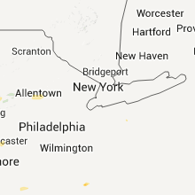
Pennsylvania
| Local Time | Report Details |
|---|---|
| 8:55 PM UTC | Tress and wires down in clinton county PA, 31.9 miles NE of State College, PA |
| 9:20 PM UTC | Widespread trees and wires down in juniata county PA, 39.5 miles E of State College, PA |
| 9:25 PM UTC | Several barns damaged in juniata county PA, 37.9 miles ESE of State College, PA |
| 9:35 PM UTC | Widespread treees and wires down in union county PA, 52.4 miles E of State College, PA |
| 9:40 PM UTC | Damage to homes along route 147 in northumberland county PA, 55.5 miles E of State College, PA |
| 9:45 PM UTC | Emergency manager on the scene of possible tornado damage in union county PA, 52.4 miles E of State College, PA |
| 9:45 PM UTC | Widespread trees and wires down along route 15 in union county PA, 53.6 miles E of State College, PA |
| 10:45 PM UTC | Widespread trees and wires down in tamaqua in schuylkill county PA, 43.7 miles SSW of Scranton, PA |
| 11:22 PM UTC | Trees down in carbon county PA, 41.8 miles S of Scranton, PA |
| 11:30 PM UTC | Trees down and also roof damage in carbon county PA, 38.7 miles S of Scranton, PA |
| 11:36 PM UTC | Trees down... funnels sighted als in carbon county PA, 42.2 miles S of Scranton, PA |
| 12:08 AM UTC | 2 trees down in erie. numerous branches dow in erie county PA, 80.9 miles SW of Buffalo, NY |
| 12:20 AM UTC | Storm damage reported in northampton county PA, 52.3 miles SSE of Scranton, PA |
| 1:05 AM UTC | Quarter sized hail reported near Pymatuning, PA, 65.6 miles NNW of Pittsburgh, PA |
| 1:10 AM UTC | Several trees down in shenango twp in mercer county PA, 55.1 miles NNW of Pittsburgh, PA |
Maryland
| Local Time | Report Details |
|---|---|
| 10:00 PM UTC | Quarter sized hail reported near Poolesville, MD, 45.1 miles WSW of Baltimore, MD |
| 10:10 PM UTC | Quarter sized hail reported near Poolesville, MD, 45.1 miles WSW of Baltimore, MD |
| 12:10 AM UTC | Golf Ball sized hail reported near Greensboro, MD, 48 miles ESE of Baltimore, MD |
Tennessee
| Local Time | Report Details |
|---|---|
| 10:00 PM UTC | Trained spotter reported that his personal weather station recorded a wind gust of 62 mp in tipton county TN, 26 miles NE of Memphis, TN |
| 11:00 PM UTC | Wind gust to 66 mph at sheriffs office in dresde in weakley county TN, 13.9 miles NW of Mc Kenzie, TN |
| 11:15 PM UTC | Quarter sized hail reported near Jackson, TN, 37.6 miles SSW of Mc Kenzie, TN, majority of the hail falling was pea size...however a few quarter size stones were mixed in. reported just north of i-40. |
| 12:00 AM UTC | Sheriffs office rpts tree down on house at 400 block of north hancock road in the town of big roc in stewart county TN, 49.5 miles NE of Mc Kenzie, TN |
| 12:00 AM UTC | Sheriffs relays public report of possible tornado damage in the town of big rock on cherry hollow rd. roof blown off house...trailer lifted off groun in stewart county TN, 49.5 miles NE of Mc Kenzie, TN |
| 12:08 AM UTC | Sheriffs office rpts tree down on house on earl coppage road in the town of big roc in stewart county TN, 49.5 miles NE of Mc Kenzie, TN |
| 12:35 AM UTC | Quarter sized hail reported near Decaturville, TN, 46.3 miles SSE of Mc Kenzie, TN |
| 4:50 AM CDT | East nashville...40+ trees down. numerous powerpoles dow in davidson county TN, 1.6 miles E of Nashville, TN |
| 9:55 AM UTC | Near opry mills in davidson county TN, 4 miles NE of Nashville, TN |
| 4:55 AM CDT | Half Dollar sized hail reported near Nashville, TN, 4 miles NE of Nashville, TN, near opry mills |
| 9:57 AM UTC | Strong winds knocked down about a dozen trees near hadley middle school and the old hickory golf clu in davidson county TN, 9.7 miles ENE of Nashville, TN |
| 5:00 AM CDT | Trees down in madison in davidson county TN, 5.7 miles NE of Nashville, TN |
| 10:20 AM UTC | Trees down county-wide in sumner county TN, 23.5 miles NE of Nashville, TN |
| 10:45 AM UTC | Trees down county-wide in macon county TN, 48.3 miles ENE of Nashville, TN |
Florida
| Local Time | Report Details |
|---|---|
| 10:00 PM UTC | Several trees were reported down near nw 115th avenu in marion county FL, 73.9 miles NW of Orlando, FL |
| 10:10 PM UTC | Pine tree reported down blocking road near intersection of west highway 326 and nw highway 27. time of event based on radar imager in marion county FL, 77.5 miles NW of Orlando, FL |
Virginia
| Local Time | Report Details |
|---|---|
| 10:12 PM UTC | Tree down across road in greensville county VA, 60.9 miles S of Richmond, VA |
| 10:50 PM UTC | Quarter sized hail reported near Amherst, VA, 54.2 miles ENE of Roanoke, VA, quarter size hail reported on deerfield drive. |
| 12:20 AM UTC | Quarter sized hail reported near Hampton, VA, 25.5 miles NNW of Virginia Beach, VA, hail covering ground |
Nebraska
| Local Time | Report Details |
|---|---|
| 11:46 PM UTC | Quarter sized hail reported near Culbertson, NE, 42.3 miles N of Colby, KS |
| 12:23 AM UTC | Quarter sized hail reported near Culbertson, NE, 47.3 miles N of Colby, KS |
| 12:25 AM UTC | Golf Ball sized hail reported near Imperial, NE, 59.3 miles ENE of Yuma, CO, report was relayed via sheriffs office...time was estimated. |
| 12:45 AM UTC | Quarter sized hail reported near Imperial, NE, 58.4 miles ENE of Yuma, CO, pea to marble size hail reported covering ground...largest hail size of a quarter. |
| 1:00 AM UTC | Quarter sized hail reported near Imperial, NE, 60.2 miles ENE of Yuma, CO |
New York
| Local Time | Report Details |
|---|---|
| 12:38 AM UTC | Quarter sized hail reported near Long Island City, NY, 20.6 miles S of Colby, KS |
| 12:43 AM UTC | Multiple trees and power lines down in chautauqua county NY, 67.2 miles SW of Buffalo, NY |
| 12:48 AM UTC | Multiple trees and power lines down in chautauqua county NY, 70.7 miles SSW of Buffalo, NY |
| 1:00 AM UTC | Multiple trees abd power lines down in chautauqua county NY, 63.8 miles SSW of Buffalo, NY |
| 1:08 AM UTC | Multiple trees and power lines down in chautauqua county NY, 61.9 miles SSW of Buffalo, NY |
New Jersey
| Local Time | Report Details |
|---|---|
| 12:55 AM UTC | Trees down in southeastern warren county... mainly in washington tw in warren county NJ, 53.1 miles W of Brooklyn, NY |
West Virginia
| Local Time | Report Details |
|---|---|
| 1:14 AM UTC | Tree down on mount olive road and tree down morgan road both in macarthur in raleigh county WV, 47 miles SSE of Charleston, WV |
| 2:16 AM UTC | Power line down on woodstone road in wood county WV, 59.1 miles N of Charleston, WV |
| 2:16 AM UTC | Power lines down in cabell county WV, 31.4 miles W of Charleston, WV |
| 2:59 AM UTC | Numerous trees and power lines down across the huntington area in cabell county WV, 43.1 miles W of Charleston, WV |
| 3:06 AM UTC | Numerous trees and power lines down across the huntington area in cabell county WV, 43.1 miles W of Charleston, WV |
Connect with Interactive Hail Maps