

Hail Map for Tuesday, May 24, 2011

Number of Impacted Households on 5/24/2011
0
Impacted by 1" or Larger Hail
0
Impacted by 1.75" or Larger Hail
0
Impacted by 2.5" or Larger Hail
Square Miles of Populated Area Impacted on 5/24/2011
0
Impacted by 1" or Larger Hail
0
Impacted by 1.75" or Larger Hail
0
Impacted by 2.5" or Larger Hail


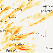


Cities Most Affected by Hail Storms of 5/24/2011
| Hail Size | Demographics of Zip Codes Affected | ||||||
|---|---|---|---|---|---|---|---|
| City | Count | Average | Largest | Pop Density | House Value | Income | Age |
| Rush Center, KS | 5 | 3.30 | 6.00 | 3 | $31k | $31.9k | 50.1 |
| Haslet, TX | 6 | 2.33 | 4.25 | 361 | $173k | $75.0k | 32.9 |
| Ness City, KS | 4 | 3.13 | 4.25 | 5 | $46k | $32.2k | 47.5 |
| Keller, TX | 4 | 2.75 | 4.25 | 3597 | $42k | $20.2k | 32.8 |
| Ingalls, KS | 4 | 2.75 | 2.75 | 1 | $71k | $39.0k | 35.9 |
| Springtown, TX | 5 | 2.15 | 2.75 | 180 | $88k | $43.7k | 37.6 |
| Fort Worth, TX | 5 | 1.95 | 2.75 | 1021 | $81k | $34.6k | 32.4 |
| Arlington, TX | 4 | 2.00 | 2.75 | 3562 | $100k | $40.2k | 35.9 |
| Dallas, TX | 3 | 2.33 | 2.75 | 2382 | $56k | $27.5k | 38.8 |
| Noble, OK | 3 | 2.09 | 2.51 | 165 | $68k | $35.4k | 36.9 |
| Garden City, KS | 2 | 3.13 | 4.25 | 44 | $85k | $38.1k | 30.2 |
| Irving, TX | 2 | 3.00 | 4.25 | 4932 | $90k | $37.3k | 30.3 |
| Kaufman, TX | 2 | 2.25 | 2.75 | 111 | $75k | $42.2k | 36.0 |
| Alexander, KS | 2 | 2.25 | 2.75 | 1 | $30k | $13.1k | 52.9 |
| Pierceville, KS | 2 | 2.25 | 2.75 | 5 | $35k | $46.0k | 28.5 |
| Sherman, TX | 2 | 2.25 | 2.75 | 305 | $53k | $31.7k | 31.9 |
| Azle, TX | 1 | 4.00 | 4.00 | 413 | $86k | $43.5k | 41.0 |
| Livingston, TN | 2 | 1.88 | 2.00 | 92 | $76k | $26.8k | 42.3 |
| Lancaster, KS | 2 | 1.75 | 1.75 | 11 | $49k | $37.3k | 41.8 |
| Grapevine, TX | 2 | 1.75 | 1.75 | 1309 | $157k | $71.9k | 37.5 |
| Watonga, OK | 1 | 3.00 | 3.00 | 16 | $47k | $27.7k | 33.5 |
| Newcastle, OK | 1 | 2.75 | 2.75 | 131 | $92k | $48.7k | 39.0 |
| Crandall, TX | 1 | 2.75 | 2.75 | 110 | $99k | $53.5k | 34.6 |
| Mineral Wells, TX | 1 | 2.75 | 2.75 | 121 | $45k | $30.1k | 36.2 |
| Washington, OK | 1 | 2.50 | 2.50 | 40 | $82k | $43.0k | 37.8 |
| Cimarron, KS | 1 | 2.00 | 2.00 | 2 | $80k | $40.2k | 34.1 |
| Celina, TX | 1 | 2.00 | 2.00 | 90 | $114k | $52.8k | 36.1 |
| Jefferson, NC | 1 | 2.00 | 2.00 | 106 | $101k | $29.9k | 46.2 |
| Hobart, OK | 1 | 1.75 | 1.75 | 21 | $35k | $25.9k | 39.1 |
| Coppell, TX | 1 | 1.75 | 1.75 | 2442 | $211k | $96.8k | 37.7 |
| Rosston, TX | 1 | 1.75 | 1.75 | 4 | $0k | $0.0k | 43.5 |
| Ada, OK | 1 | 1.75 | 1.75 | 101 | $62k | $27.0k | 34.4 |
| Bedford, TX | 1 | 1.75 | 1.75 | 4784 | $126k | $59.6k | 41.3 |
| Oklahoma City, OK | 1 | 1.75 | 1.75 | 3212 | $57k | $31.4k | 33.0 |
| Hydro, OK | 1 | 1.75 | 1.75 | 10 | $51k | $29.9k | 39.3 |
| Apache, OK | 1 | 1.75 | 1.75 | 11 | $49k | $28.1k | 41.0 |
| Great Bend, KS | 1 | 1.75 | 1.75 | 78 | $61k | $33.4k | 38.0 |
| Saint Jo, TX | 1 | 1.75 | 1.75 | 5 | $46k | $30.5k | 43.1 |
| Taylor, TX | 1 | 1.75 | 1.75 | 128 | $82k | $41.0k | 36.1 |
| Traphill, NC | 1 | 1.75 | 1.75 | 31 | $83k | $35.5k | 42.6 |
| Lake City, KS | 1 | 1.75 | 1.75 | 0 | $23k | $42.8k | 52.8 |
| Cedar Hill, TX | 1 | 1.75 | 1.75 | 1188 | $96k | $60.1k | 34.2 |
| Howe, OK | 1 | 1.75 | 1.75 | 38 | $54k | $28.3k | 37.8 |
| Monticello, IA | 1 | 1.75 | 1.75 | 41 | $84k | $37.1k | 42.6 |
| Penhook, VA | 1 | 1.75 | 1.75 | 40 | $115k | $38.7k | 51.1 |
| Francesville, IN | 1 | 1.75 | 1.75 | 13 | $72k | $38.9k | 43.0 |
| Jacksboro, TX | 1 | 1.75 | 1.75 | 9 | $47k | $33.5k | 37.9 |
| Coats, KS | 1 | 1.75 | 1.75 | 1 | $17k | $33.4k | 37.5 |
| Prophetstown, IL | 1 | 1.75 | 1.75 | 26 | $77k | $38.1k | 45.6 |
| Beggs, OK | 1 | 1.75 | 1.75 | 26 | $61k | $34.0k | 38.8 |
| Chesapeake, VA | 1 | 1.75 | 1.75 | 1329 | $127k | $55.8k | 38.4 |
| Euless, TX | 1 | 1.75 | 1.75 | 2614 | $98k | $41.1k | 33.5 |
| Norman, OK | 1 | 1.75 | 1.75 | 1507 | $76k | $30.9k | 29.8 |
| Forestburg, TX | 1 | 1.75 | 1.75 | 7 | $62k | $34.0k | 47.3 |
| Marion, IN | 1 | 1.75 | 1.75 | 256 | $58k | $32.3k | 35.8 |
| Gainesville, TX | 1 | 1.75 | 1.75 | 74 | $70k | $35.5k | 38.3 |
| Lawton, OK | 1 | 1.75 | 1.75 | 161 | $68k | $29.6k | 33.9 |
| Whitesboro, TX | 1 | 1.75 | 1.75 | 44 | $69k | $35.6k | 41.2 |
| Millsap, TX | 1 | 1.75 | 1.75 | 33 | $71k | $39.9k | 43.1 |
| Elkhart, KS | 1 | 1.75 | 1.75 | 2 | $83k | $49.2k | 38.3 |
| Rozel, KS | 1 | 1.75 | 1.75 | 1 | $29k | $35.6k | 49.3 |
Hail and Wind Damage Spotted on 5/24/2011
Filter by Report Type:Hail ReportsWind Reports
States Impacted
Kentucky, North Carolina, Kansas, Virginia, Colorado, Tennessee, Nebraska, Missouri, Oklahoma, Iowa, Illinois, Maryland, Texas, Wyoming, Indiana, ArkansasKentucky
| Local Time | Report Details |
|---|---|
| 12:03 PM UTC | Power lines and trees are down and blocking the road in the delta community on brammer hill roa in wayne county KY, 69.1 miles SSW of Irvine, KY |
| 12:06 PM UTC | Trees and limbs were blown down in monticell in wayne county KY, 76.4 miles SW of Irvine, KY |
| 12:33 PM UTC | Trees down north end of the count in mccreary county KY, 62.1 miles NNW of Knoxville, TN |
| 12:49 PM UTC | Limbs that are 2 to 3 inches in diameter are broken on hwy 2 in whitley county KY, 54.3 miles S of Irvine, KY |
| 1:09 PM UTC | Leslie county transportation director reported 2-3 trees down on cars along ky 3427 near wolfe creek. time est from rada in leslie county KY, 58.6 miles SE of Irvine, KY |
| 1:30 PM UTC | Trees are down across the area. one tree fell onto a car and same tree into house. two homes sustained damag in leslie county KY, 57.6 miles SE of Irvine, KY |
| 2:30 PM UTC | Trees down on telephone lines in paw paw communit in clay county KY, 41 miles SSE of Irvine, KY |
| 5:30 PM UTC | Two trees down across roa in knox county KY, 58 miles S of Irvine, KY |
| 7:26 PM UTC | Tree across 110 in letcher county KY, 50.5 miles NW of Bristol, TN |
| 7:34 PM UTC | Trees down along hwy 25w near mm16. time est from rada in whitley county KY, 58.9 miles NNW of Knoxville, TN |
| 7:43 PM UTC | Several trees down along ky 628 and ky 2996 near emlyn. time est from rada in whitley county KY, 52.4 miles NNW of Knoxville, TN |
| 7:43 PM UTC | Trees down over rt 856 around the williamsburg area. time est from rada in whitley county KY, 55.5 miles NNW of Knoxville, TN |
| 7:47 PM UTC | Trees down on alum ford road at yahoo fall in mccreary county KY, 66.2 miles NNW of Knoxville, TN |
| 8:09 PM UTC | Trees down on rock creek road...whirly circle and lum strunk roa in mccreary county KY, 54.2 miles NNW of Knoxville, TN |
| 8:09 PM UTC | Trees down over ky 92. time est from rada in whitley county KY, 50.3 miles N of Knoxville, TN |
| 8:12 PM UTC | Quarter sized hail reported near Strunk, KY, 52.8 miles NNW of Knoxville, TN, began hailing at 410pm as dime sized. |
| 8:34 PM UTC | Tree down in jamestow in russell county KY, 77.4 miles SSE of Louisville, KY |
| 8:35 PM UTC | Tree blown down blocking hwy 25 in bell county KY, 52.6 miles NNE of Knoxville, TN |
| 10:40 PM UTC | Several trees down in gibbs...reported by publi in knox county KY, 47.1 miles S of Irvine, KY |
North Carolina
| Local Time | Report Details |
|---|---|
| 12:30 PM UTC | Trees down on forbush high school propert in yadkin county NC, 69.1 miles NNE of Charlotte, NC |
| 5:00 PM UTC | One tree down on east warren avenu in rockingham county NC, 52.8 miles S of Roanoke, VA |
| 5:01 PM UTC | One tree down on chestnut stree in rockingham county NC, 53.7 miles SSE of Roanoke, VA |
| 5:30 PM UTC | Trees down in tow in rockingham county NC, 60.8 miles S of Roanoke, VA |
| 5:54 PM UTC | 911 center reported one tree down on cunningham road in northwestern person county in person county NC, 57.6 miles NNW of Raleigh, NC |
| 7:28 PM UTC | Ping Pong Ball sized hail reported near McGrady, NC, 57.8 miles ESE of Bristol, TN |
| 7:48 PM UTC | Golf Ball sized hail reported near Traphill, NC, 68.4 miles ESE of Bristol, TN |
| 8:00 PM UTC | Large bradford pear tree split in wilkes county NC, 72.4 miles ESE of Bristol, TN |
| 8:03 PM UTC | Half Dollar sized hail reported near Thurmond, NC, 73.5 miles ESE of Bristol, TN |
| 8:10 PM UTC | Ping Pong Ball sized hail reported near State Road, NC, 75 miles N of Charlotte, NC |
| 8:23 PM UTC | Ping Pong Ball sized hail reported near Dobson, NC, 76 miles N of Charlotte, NC |
| 8:25 PM UTC | Trees dow in wilkes county NC, 68.2 miles ESE of Bristol, TN |
| 8:32 PM UTC | Quarter sized hail reported near Siloam, NC, 75.3 miles SSW of Roanoke, VA, quarter size hail on atkinson road. |
| 8:53 PM UTC | Quarter sized hail reported near King, NC, 71 miles SSW of Roanoke, VA, mainly marble size hail but a few up to quarter size on musket drive. |
| 9:02 PM UTC | Quarter sized hail reported near Germanton, NC, 70.4 miles SSW of Roanoke, VA, quarter size hail covering the ground on boles road. |
| 9:52 PM UTC | Hen Egg sized hail reported near Jefferson, NC, 49.7 miles ESE of Bristol, TN |
| 9:55 PM UTC | Quarter sized hail reported near Boone, NC, 39.2 miles SE of Bristol, TN |
| 9:58 PM UTC | Quarter sized hail reported near Boone, NC, 40.5 miles SE of Bristol, TN, dime to quarter size hail just north of boone. |
| 10:00 PM UTC | Quarter sized hail reported near Boone, NC, 40 miles SE of Bristol, TN, fell for several minutes. |
| 10:25 PM UTC | Trees down near mulberry in wilkes county NC, 62.9 miles ESE of Bristol, TN |
| 10:49 PM UTC | A couple of trees down near millers cree in wilkes county NC, 61 miles ESE of Bristol, TN |
| 10:57 PM UTC | Trees down on power lines approximately 3 miles wnw of intersection of state route 16 and highway 421 in wilkes county NC, 60 miles ESE of Bristol, TN |
| 11:00 PM UTC | Sevral trees reported down by amateur radio operato in wilkes county NC, 62.1 miles ESE of Bristol, TN |
| 11:10 PM UTC | Two large trees down on crossroads church roa in surry county NC, 76.1 miles SW of Roanoke, VA |
| 11:34 PM UTC | About 4 trees blown down in the hamptonville are in yadkin county NC, 61.2 miles N of Charlotte, NC |
| 12:10 AM UTC | Trees down on elm grove church roa in rockingham county NC, 65.8 miles WNW of Raleigh, NC |
| 12:11 AM UTC | Trees down on mizpah church roa in rockingham county NC, 65 miles WNW of Raleigh, NC |
| 12:15 AM UTC | Trees down on fieldcrest roa in rockingham county NC, 54 miles SSE of Roanoke, VA |
| 12:30 AM UTC | Trees down on forbush high school propert in yadkin county NC, 69.1 miles NNE of Charlotte, NC |
| 12:40 AM UTC | Numerous large tree limbs down in caswell county NC, 62.6 miles SSE of Roanoke, VA |
| 12:55 AM UTC | Several large tree limbs blown down on brandy trace lan in rockingham county NC, 69.9 miles S of Roanoke, VA |
Kansas
| Local Time | Report Details |
|---|---|
| 12:35 PM UTC | Storm damage reported in russell county KS, 29.2 miles ENE of Hays, KS |
| 12:58 PM UTC | Storm damage reported in lincoln county KS, 50.3 miles ENE of Hays, KS |
| 12:58 PM UTC | Quarter sized hail reported near Sylvan Grove, KS, 50.3 miles ENE of Hays, KS |
| 2:43 PM UTC | Golf Ball sized hail reported near Lancaster, KS, 50.1 miles NW of Kansas City, MO |
| 4:20 PM UTC | Golf Ball sized hail reported near Lancaster, KS, 50.1 miles NW of Kansas City, MO |
| 6:05 PM UTC | Quarter sized hail reported near Rolla, KS, 77.6 miles SSW of Garden City, KS, hail is covering the ground. |
| 6:10 PM UTC | Quarter sized hail reported near Rolla, KS, 78.1 miles SSW of Garden City, KS |
| 6:48 PM UTC | Quarter sized hail reported near Hugoton, KS, 59.4 miles SSW of Garden City, KS |
| 7:27 PM UTC | Quarter sized hail reported near Ulysses, KS, 31.3 miles SSW of Garden City, KS |
| 7:35 PM UTC | Golf Ball sized hail reported near Elkhart, KS, 81.8 miles SW of Garden City, KS, hail covered the ground and accumulated to a depth of six inches along the side of buildings. the wind gusted to 60 mph. |
| 7:35 PM UTC | Baseball sized hail reported near Ingalls, KS, 16.8 miles E of Garden City, KS, the hail broke a hole through an insu |
| 7:37 PM UTC | Baseball sized hail reported near Ingalls, KS, 17.1 miles E of Garden City, KS, most hail varied from the size of peas to quarters. funnel clouds also were observed. |
| 8:05 PM UTC | Quarter sized hail reported near Garden City, KS, 1 miles NE of Garden City, KS |
| 8:15 PM UTC | Quarter sized hail reported near Ulysses, KS, 51.3 miles SW of Garden City, KS |
| 8:15 PM UTC | Baseball sized hail reported near Pierceville, KS, 13 miles ESE of Garden City, KS, tennis ball to baseball sized hail reported. |
| 8:20 PM UTC | Hen Egg sized hail reported near Garden City, KS, 8.4 miles E of Garden City, KS, reported from garden city faa tower personnel. |
| 8:23 PM UTC | Golf Ball sized hail reported near Pierceville, KS, 11.7 miles ESE of Garden City, KS |
| 3:27 PM CDT | Grapefruit sized hail reported near Garden City, KS, 12.7 miles ESE of Garden City, KS, baseball to softball sized hail was reported. |
| 8:35 PM UTC | Baseball sized hail reported near Ingalls, KS, 16.8 miles E of Garden City, KS, the hail broke a hole through an insu |
| 8:37 PM UTC | Baseball sized hail reported near Ingalls, KS, 17.1 miles E of Garden City, KS, most hail varied from the size of peas to quarters. funnel clouds also were observed. |
| 8:50 PM UTC | Quarter sized hail reported near Garden City, KS, 23.2 miles ENE of Garden City, KS |
| 9:00 PM UTC | Hen Egg sized hail reported near Cimarron, KS, 26.9 miles ENE of Garden City, KS |
| 9:00 PM UTC | Employee also reported nickel-sized hail...three broken windows and some roof damage to residenc in sherman county KS, 43.8 miles WSW of Colby, KS |
| 9:00 PM UTC | Employee also reports nickel-sized hail in sherman county KS, 43.8 miles WSW of Colby, KS |
| 9:06 PM UTC | Golf Ball sized hail reported near Lake City, KS, 62.6 miles NNE of Woodward, OK |
| 9:06 PM UTC | Storm damage reported in sherman county KS, 39.5 miles W of Colby, KS |
| 9:10 PM UTC | Storm damage reported in lane county KS, 37.1 miles NE of Garden City, KS |
| 9:15 PM UTC | Quarter sized hail reported near Goodland, KS, 35.8 miles W of Colby, KS |
| 9:18 PM UTC | Golf Ball sized hail reported near Coats, KS, 79.6 miles NNE of Woodward, OK |
| 9:24 PM UTC | Baseball sized hail reported near , , 65.5 miles SSE of Hays, KS, this report by the public was heard over the police scanner. |
| 9:24 PM UTC | 69 knot wind gust reported at goodland asos in sherman county KS, 35.8 miles W of Colby, KS |
| 9:24 PM UTC | Estimated by an experience storm spotte in pratt county KS, 79.9 miles W of Wichita, KS |
| 9:25 PM UTC | Game warden reported two circle pivot irrigation systems damaged. time estimate in sherman county KS, 35.6 miles W of Colby, KS |
| 9:25 PM UTC | Quarter sized hail reported near Dighton, KS, 50.5 miles NNE of Garden City, KS |
| 9:27 PM UTC | Storm damage reported in kingman county KS, 42.5 miles W of Wichita, KS |
| 9:30 PM UTC | Sections of fence blown down as well as a tree. wind driven half inch hail persisted for 20 minutes causing hail damage to trees and propert in sherman county KS, 36 miles W of Colby, KS |
| 9:35 PM UTC | Storm damage reported in sherman county KS, 26.9 miles W of Colby, KS |
| 9:35 PM UTC | Power pole down hwy 24 in sherman county KS, 26.9 miles W of Colby, KS |
| 9:37 PM UTC | Storm damage reported in kingman county KS, 42.5 miles W of Wichita, KS |
| 9:41 PM UTC | Ksn weather lab site measures 59 mph wind gus in reno county KS, 34.2 miles WNW of Wichita, KS |
| 9:41 PM UTC | Emergency manager reports tree limbs down in arlington but no size was specifie in reno county KS, 48.5 miles WNW of Wichita, KS |
| 9:45 PM UTC | Golf Ball sized hail reported near Rozel, KS, 38 miles S of Hays, KS |
| 9:45 PM UTC | Emergency manager reports a 6 inch tree limb through a roof in west central hutchinso in reno county KS, 41 miles NW of Wichita, KS |
| 9:48 PM UTC | Storm damage reported in scott county KS, 35.3 miles N of Garden City, KS |
| 9:51 PM UTC | Asos measures 69 mph wind gus in reno county KS, 41 miles NW of Wichita, KS |
| 9:56 PM UTC | Emergency manager reports 12 inch diameter tree down in hutchinso in reno county KS, 41 miles NW of Wichita, KS |
| 9:56 PM UTC | 5 power poles broken near monument. poles all laying to the eas in logan county KS, 20.6 miles S of Colby, KS |
| 9:56 PM UTC | Eight power poles broken near monument. poles all laying to the east. correction from previous report of five poles dow in logan county KS, 20.6 miles S of Colby, KS |
| 4:56 PM CDT | Grapefruit sized hail reported near Ness City, KS, 50.7 miles ENE of Garden City, KS, several baseball sized hail stones were reported in addition to a couple that were softball sized. |
| 9:59 PM UTC | Power pole down in sherman county KS, 50.2 miles W of Colby, KS |
| 10:00 PM UTC | Live seven-inch diameter tree limb down. several pieces of tin roofing removed from a shed. time of event estimated from nearby report in logan county KS, 34.4 miles SSW of Colby, KS |
| 10:00 PM UTC | Golf Ball sized hail reported near Great Bend, KS, 51.9 miles SE of Hays, KS |
| 10:02 PM UTC | Quarter sized hail reported near Great Bend, KS, 45.2 miles SE of Hays, KS, amateur radio reports some quarter sized hail but mostly dime or smaller. |
| 10:02 PM UTC | Power lines reported down via emergency manager at 82nd and riverto in reno county KS, 51.3 miles NW of Wichita, KS |
| 10:04 PM UTC | Railroad crossing arm damaged according to emergency manager at k14 and us 5 in reno county KS, 51.2 miles WNW of Wichita, KS |
| 10:06 PM UTC | Emergency manager reports 6 to 8 inch tree limbs down as well as square hay bales thrown 30 feet and an unoccupied porta potty thrown 50 yard in sedgwick county KS, 19 miles W of Wichita, KS |
| 10:08 PM UTC | Baseball sized hail reported near Ness City, KS, 43.2 miles SW of Hays, KS |
| 10:09 PM UTC | Baseball sized hail reported near Ness City, KS, 43.1 miles SW of Hays, KS |
| 10:11 PM UTC | Kwch storm chaser reports 60 mph winds in andal in sedgwick county KS, 17.6 miles WNW of Wichita, KS |
| 10:12 PM UTC | Power lines reported down via emergency manager at 82nd and riverto in reno county KS, 51.3 miles NW of Wichita, KS |
| 10:16 PM UTC | Baseball sized hail reported near Rush Center, KS, 27.2 miles SSE of Hays, KS |
| 10:17 PM UTC | Amateur radio reports heavy rain and 60 mph wind in sumner county KS, 29 miles S of Wichita, KS |
| 10:18 PM UTC | Trained spotter reports 70 mph winds 1 east of highway 4 and 15 in ellsworth county KS, 62 miles E of Hays, KS |
| 10:20 PM UTC | Ping Pong Ball sized hail reported near Ness City, KS, 37.4 miles SW of Hays, KS |
| 5:20 PM CDT | Baseball sized hail reported near Ness City, KS, 42.7 miles SW of Hays, KS |
| 5:21 PM CDT | Softball sized hail reported near Timken, KS, 28.9 miles SSE of Hays, KS, giant hail measured at 6 inches in diameter fell through the roof of a church in timken. |
| 10:22 PM UTC | Amateur radio reports 18 to 20 inch diameter trees down north of k19 and 28 in barton county KS, 49 miles SE of Hays, KS |
| 10:24 PM UTC | Kwch storm chaser reports 50 to 60 mph winds near caldwel in sumner county KS, 47.1 miles SSW of Wichita, KS |
| 5:30 PM CDT | Grapefruit sized hail reported near Timken, KS, 28.9 miles SSE of Hays, KS, hail was covering the ground. |
| 10:34 PM UTC | Storm damage reported in reno county KS, 39.4 miles NW of Wichita, KS |
| 10:35 PM UTC | Amateur radio reports 70 mph winds for approximately 5 minute in mcpherson county KS, 33.4 miles N of Wichita, KS |
| 10:44 PM UTC | Emergency manager reports power lines down at k96 and us 54 which blocked traffic on the ramp from south bound k96 to east bound 5 in sedgwick county KS, 4.2 miles E of Wichita, KS |
| 10:44 PM UTC | Emergency manager reports the city of nickerson is without powe in reno county KS, 52.1 miles NW of Wichita, KS |
| 10:44 PM UTC | Emergency manager reports power lines down at 143rd street and us 5 in sedgwick county KS, 5.3 miles E of Wichita, KS |
| 10:48 PM UTC | Golf Ball sized hail reported near Alexander, KS, 30.1 miles SSW of Hays, KS |
| 10:49 PM UTC | Ping Pong Ball sized hail reported near Pfeifer, KS, 13.2 miles SSE of Hays, KS |
| 10:53 PM UTC | Trained spotter estimates wind gusts to 60 to 65 mp in butler county KS, 27.4 miles NNE of Wichita, KS |
| 11:00 PM UTC | Baseball sized hail reported near Alexander, KS, 30.1 miles SSW of Hays, KS |
| 11:15 PM UTC | Law enforcement reports 60 mph winds at timber south of 40t in marion county KS, 34 miles NNE of Wichita, KS |
| 11:15 PM UTC | A roof was blown from a building and power poles were blown down in lacross in rush county KS, 23.5 miles S of Hays, KS |
| 11:16 PM UTC | Fire fighter reports winds of 65 mph if not greate in butler county KS, 32.5 miles NE of Wichita, KS |
| 11:17 PM UTC | Trained spotter reports 8 to 10 inch diameter tree limbs down on 3rd stree in mcpherson county KS, 63.6 miles NNW of Wichita, KS |
| 11:20 PM UTC | Quarter sized hail reported near Hoisington, KS, 21.8 miles SE of Hays, KS, trained spotter reports quarter and nickel sized hail. |
| 11:20 PM UTC | High winds produced minor roof d in rush county KS, 28.4 miles S of Hays, KS |
| 11:21 PM UTC | Quarter sized hail reported near Hoisington, KS, 21.8 miles SE of Hays, KS |
| 11:24 PM UTC | Emergency manager reports that a semi trailer was blown over between mile markers 82 and 83 on the kansas turnpik in butler county KS, 36 miles ENE of Wichita, KS |
| 11:26 PM UTC | Florence fire department reports winds of 60 mph and heavy rai in marion county KS, 44.1 miles NNE of Wichita, KS |
| 11:28 PM UTC | Quarter sized hail reported near Gorham, KS, 18.7 miles ESE of Hays, KS |
| 11:30 PM UTC | Golf Ball sized hail reported near Rush Center, KS, 32.1 miles S of Hays, KS |
| 11:36 PM UTC | Golf Ball sized hail reported near Rush Center, KS, 32.1 miles S of Hays, KS |
| 11:45 PM UTC | Law enforcement estimates 70 mph wind in barton county KS, 45.6 miles SSE of Hays, KS |
| 11:55 PM UTC | Storm damage reported in barton county KS, 44.4 miles SE of Hays, KS |
| 12:00 AM UTC | Storm damage reported in butler county KS, 14 miles E of Wichita, KS |
| 12:05 AM UTC | Storm damage reported in barton county KS, 38.4 miles SE of Hays, KS |
| 12:05 AM UTC | Law enforcement reports a roof was blown off of a buildin in barton county KS, 45.2 miles SE of Hays, KS |
| 12:08 AM UTC | Quarter sized hail reported near Stafford, KS, 72.1 miles SSE of Hays, KS |
| 12:11 AM UTC | Amateur radio reports sustained 60 mph wind in barton county KS, 34.3 miles ESE of Hays, KS |
| 12:15 AM UTC | Storm damage reported in barton county KS, 44.1 miles ESE of Hays, KS |
| 12:20 AM UTC | Storm damage reported in barton county KS, 48.3 miles SE of Hays, KS |
| 12:28 AM UTC | Storm damage reported in elk county KS, 53.9 miles ESE of Wichita, KS |
| 12:35 AM UTC | Storm damage reported in ellsworth county KS, 53.5 miles ESE of Hays, KS |
| 12:43 AM UTC | Storm damage reported in russell county KS, 44.6 miles ENE of Hays, KS |
| 12:44 AM UTC | Amateur radio reports a 12 inch diameter tree limb dow in chautauqua county KS, 60.8 miles SW of Chanute, KS |
| 12:44 AM UTC | Emergency manager reports several trees uprooted up to 3.5 feet in diamete in greenwood county KS, 46.9 miles WNW of Chanute, KS |
| 12:45 AM UTC | Storm damage reported in greenwood county KS, 43.7 miles WNW of Chanute, KS |
| 12:45 AM UTC | Law enforcement reports roof off of a barn and tree damage of undetermined siz in greenwood county KS, 50.3 miles W of Chanute, KS |
| 12:47 AM UTC | Storm damage reported in ellsworth county KS, 49.8 miles E of Hays, KS |
| 12:52 AM UTC | Trained spotter estimates 70 to 80 mph winds 2 north and 5 west of lyon in rice county KS, 67.4 miles NW of Wichita, KS |
| 12:57 AM UTC | Trained spotter reports wind gusts of 70 mp in montgomery county KS, 53.3 miles SSW of Chanute, KS |
| 1:15 AM UTC | Storm damage reported in lincoln county KS, 64.7 miles E of Hays, KS |
| 1:17 AM UTC | Several power lines down in the city of chautauqu in chautauqua county KS, 60.8 miles SW of Chanute, KS |
| 1:21 AM UTC | Amateur radio reports an 18 inch tree down on chautauqua stree in chautauqua county KS, 55.3 miles SW of Chanute, KS |
| 1:30 AM UTC | Storm damage reported in montgomery county KS, 40.7 miles S of Chanute, KS |
| 1:34 AM UTC | Storm damage reported in labette county KS, 25.6 miles SSE of Chanute, KS |
| 1:45 AM UTC | Power is out around minneapolis in ottawa county KS, 61.8 miles W of Manhattan, KS |
| 1:51 AM UTC | Emergency manager reports one business at cloud and s 9th streets having windows blown out of their store. a 10 inch diameter and a 15 to 18 inch diameter trees reporte in saline county KS, 62.1 miles WSW of Manhattan, KS |
| 1:51 AM UTC | Fire department reports powerlines down on santa fe avenue near prescott near the salina regional health cente in saline county KS, 62.1 miles WSW of Manhattan, KS |
| 1:58 AM UTC | Trees down on 90th road between faulkner and melrose kansa in cherokee county KS, 46.9 miles SSE of Chanute, KS |
| 2:05 AM UTC | Storm damage reported in neosho county KS, 19.1 miles SE of Chanute, KS |
| 2:05 AM UTC | Kake storm chasers report powerlines blocking santa fe and crawfor in saline county KS, 62.1 miles WSW of Manhattan, KS |
| 2:05 AM UTC | 2 outbuildings flattened. 1 car flippe in neosho county KS, 17.1 miles SE of Chanute, KS |
| 2:10 AM UTC | Power lines down in neosho county KS, 14 miles ESE of Chanute, KS |
| 2:20 AM UTC | Spotter estimated 50 to 60 mph winds with gust fron in dickinson county KS, 34.8 miles WSW of Manhattan, KS |
| 2:20 AM UTC | Storm damage reported in dickinson county KS, 25.2 miles WSW of Manhattan, KS |
| 2:23 AM UTC | Quarter sized hail reported near Edgerton, KS, 33 miles SW of Kansas City, MO |
| 2:46 AM UTC | Storm damage reported in johnson county KS, 21.8 miles WSW of Kansas City, MO |
| 2:55 AM UTC | Trees and power poles blown dow in cherokee county KS, 49.9 miles SE of Chanute, KS |
| 2:58 AM UTC | Storm damage reported in leavenworth county KS, 23.5 miles NW of Kansas City, MO |
| 2:58 AM UTC | Power poles and trees down 6 miles west of columbus on hwy 160 in cherokee county KS, 44.8 miles SE of Chanute, KS |
| 2:59 AM UTC | Storm damage reported in cherokee county KS, 61 miles SE of Chanute, KS |
| 2:59 AM UTC | Storm damage reported in cherokee county KS, 61 miles SE of Chanute, KS |
| 3:00 AM UTC | *** 1 inj *** suv was blown off the road at 7th and chico roa in cherokee county KS, 61 miles SE of Chanute, KS |
| 3:02 AM UTC | Storm damage reported in cherokee county KS, 54.4 miles SE of Chanute, KS |
| 3:06 AM UTC | Storm damage reported in leavenworth county KS, 27.4 miles NW of Kansas City, MO |
| 4:16 AM UTC | Storm damage reported in neosho county KS, 1 miles SSW of Chanute, KS |
Virginia
| Local Time | Report Details |
|---|---|
| 1:53 PM UTC | Half Dollar sized hail reported near Grundy, VA, 49.3 miles N of Bristol, TN |
| 2:25 PM UTC | 1 tree dow in scott county VA, 23.9 miles WNW of Bristol, TN |
| 2:35 PM UTC | Trees down in cit in tazewell county VA, 42.1 miles NNE of Bristol, TN |
| 2:40 PM UTC | 1 tree dow in wise county VA, 42.3 miles NNW of Bristol, TN |
| 2:45 PM UTC | Few trees dow in russell county VA, 20.2 miles N of Bristol, TN |
| 2:45 PM UTC | Few trees dow in russell county VA, 32.4 miles NNE of Bristol, TN |
| 4:00 PM UTC | Trees down near town of sonta in franklin county VA, 24 miles SSE of Roanoke, VA |
| 4:10 PM UTC | Trees down north of tow in city of galax county VA, 68.2 miles SW of Roanoke, VA |
| 4:25 PM UTC | Golf Ball sized hail reported near Penhook, VA, 26.4 miles SE of Roanoke, VA |
| 4:29 PM UTC | Quarter sized hail reported near Penhook, VA, 26.4 miles SE of Roanoke, VA |
| 4:42 PM UTC | Trees down in patrick spring in patrick county VA, 46.3 miles SSW of Roanoke, VA |
| 4:45 PM UTC | Trees down south part of lake are in bedford county VA, 23 miles ESE of Roanoke, VA |
| 4:47 PM UTC | Trees down along riceville roa in pittsylvania county VA, 47.3 miles ESE of Roanoke, VA |
| 4:57 PM UTC | Trees dow in pittsylvania county VA, 49.5 miles ESE of Roanoke, VA |
| 5:08 PM UTC | Tree blown down on in pittsylvania county VA, 44.7 miles SE of Roanoke, VA |
| 5:15 PM UTC | Trees down countywid in henry county VA, 44.4 miles S of Roanoke, VA |
| 5:27 PM UTC | Quarter sized hail reported near Danville, VA, 58.4 miles SE of Roanoke, VA |
| 5:30 PM UTC | Many trees dow in halifax county VA, 59.6 miles ESE of Roanoke, VA |
| 5:55 PM UTC | 5-6 large limbs blown dow in charlotte county VA, 55.7 miles SW of Richmond, VA |
| 6:15 PM UTC | Large tree blown over in mecklenburg county VA, 59.5 miles SSW of Richmond, VA |
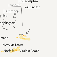
| 7:27 PM UTC | Numerous trees down on property including one on the house. call from individual and from law enforcement in the area. in sussex county VA, 49.3 miles SSE of Richmond, VA |
| 7:34 PM UTC | Storm damage reported in southampton county VA, 55.6 miles W of Virginia Beach, VA |
| 7:41 PM UTC | Large tree limbs down in southampton county VA, 50.1 miles W of Virginia Beach, VA |
| 7:41 PM UTC | Tree down as well as large tree limbs...shingle damage to house in southampton county VA, 50.1 miles W of Virginia Beach, VA |
| 8:00 PM UTC | One tree down on dunbar rd in wise county VA, 41.4 miles NW of Bristol, TN |
| 8:15 PM UTC | *** 1 fatal *** crane pushed against building pinning shipyard employee in city of hampton county VA, 24 miles NNW of Virginia Beach, VA |
| 8:15 PM UTC | *** 1 fatal *** tstm wind gust pushed crane against building pinning shipyard employe in city of norfolk county VA, 18.5 miles NW of Virginia Beach, VA |
| 8:19 PM UTC | At lfi in city of hampton county VA, 28.2 miles NW of Virginia Beach, VA |
| 8:20 PM UTC | Trees snapped and power lines down near st. juliens creek naval anne in city of portsmouth county VA, 14.8 miles WNW of Virginia Beach, VA |
| 8:20 PM UTC | Silos knocked down and other damage in the area in accomack county VA, 38.5 miles SW of Ocean City, MD |
| 8:20 PM UTC | Quarter sized hail reported near Temperanceville, VA, 38.5 miles SW of Ocean City, MD |
| 8:22 PM UTC | Storm damage reported in anz632 county VA, 21.4 miles NW of Virginia Beach, VA |
| 8:22 PM UTC | Large tree branch down on vehicle in city of portsmouth county VA, 14.6 miles WNW of Virginia Beach, VA |
| 8:22 PM UTC | Large tree branch down on vehicle. damage to ntelos pavilio in city of portsmouth county VA, 14.6 miles WNW of Virginia Beach, VA |
| 8:24 PM UTC | Money point nos-ports...mnpv in city of chesapeake county VA, 13.5 miles W of Virginia Beach, VA |
| 4:30 PM EDT | Golf Ball sized hail reported near Chesapeake, VA, 20.1 miles WNW of Virginia Beach, VA, golfball hail reported. |
| 8:30 PM UTC | Numerous trees and power lines down...howe farms subdivisio in city of hampton county VA, 26.1 miles NNW of Virginia Beach, VA |
| 8:30 PM UTC | Trees down. one tree on hom in city of virginia b county VA, 6.9 miles WNW of Virginia Beach, VA |
| 8:30 PM UTC | *** 5 inj *** pole vault mat and other debris blown around...injuries at landstown h. in city of virginia b county VA, 2.8 miles NW of Virginia Beach, VA |
| 8:30 PM UTC | Homes in subdivision sustained shingle and roof damag in city of chesapeake county VA, 10 miles W of Virginia Beach, VA |
| 8:33 PM UTC | Vadot site va007 at high rise bridg in city of chesapeake county VA, 12.8 miles W of Virginia Beach, VA |
| 8:36 PM UTC | Storm damage reported in city of virginia b county VA, 5.4 miles NNE of Virginia Beach, VA |
| 8:36 PM UTC | 1st island chesapeake bay bridge tunnel in anz634 county VA, 15.1 miles N of Virginia Beach, VA |
| 8:37 PM UTC | Quarter sized hail reported near Cedar Bluff, VA, 42.2 miles NE of Bristol, TN, occurred at pizza hut at 107 front street |
| 8:40 PM UTC | Numerous trees down or snappe in city of virginia b county VA, 6.7 miles NNE of Virginia Beach, VA |
| 8:41 PM UTC | At kmfv in accomack county VA, 60.6 miles SW of Ocean City, MD |
| 8:42 PM UTC | Quarter sized hail reported near Virginia Beach, VA, 11.8 miles NNW of Virginia Beach, VA |
| 8:44 PM UTC | Sustained 55 gusts to 72 mph...oceana naval air station ntu in city of virginia b county VA, 5.4 miles NNE of Virginia Beach, VA |
| 8:45 PM UTC | Back bay raw in city of virginia b county VA, 9.7 miles SE of Virginia Beach, VA |
| 9:00 PM UTC | Homes in subdivision sustained shingle and roof damag in city of chesapeake county VA, 10 miles W of Virginia Beach, VA |
| 9:42 PM UTC | Tree down on flanary bridge roa in lee county VA, 50.4 miles W of Bristol, TN |
| 9:45 PM UTC | Power lines down in carroll county VA, 68.5 miles WSW of Roanoke, VA |
| 9:45 PM UTC | One tree dow in lee county VA, 48.9 miles W of Bristol, TN |
| 10:28 PM UTC | Few trees down around town in carroll county VA, 49.7 miles SW of Roanoke, VA |
| 10:33 PM UTC | Few trees down around town in carroll county VA, 62.5 miles SW of Roanoke, VA |
| 10:45 PM UTC | Franklin county public safety director reported numerous trees down due to straight-line winds blocking henry road near the intersection with providence church road in in franklin county VA, 29.8 miles S of Roanoke, VA |
| 10:53 PM UTC | One tree down along central academy roa in patrick county VA, 43.4 miles SSW of Roanoke, VA |
| 11:02 PM UTC | Storm damage reported in franklin county VA, 32.2 miles SSE of Roanoke, VA |
| 11:30 PM UTC | Storm damage reported in pittsylvania county VA, 40.6 miles SE of Roanoke, VA |
| 11:32 PM UTC | Power line down in pittsylvania county VA, 43.2 miles SE of Roanoke, VA |
| 11:43 PM UTC | Storm damage reported in pittsylvania county VA, 38.5 miles SE of Roanoke, VA |
| 11:48 PM UTC | Trees down on old richmond roa in pittsylvania county VA, 54.7 miles SE of Roanoke, VA |
| 12:11 AM UTC | Power line down in pittsylvania county VA, 58.3 miles SE of Roanoke, VA |
| 12:11 AM UTC | 2 trees down in kentuck in pittsylvania county VA, 55.1 miles SE of Roanoke, VA |
| 12:15 AM UTC | Tree and power line blown down on higway 5 in halifax county VA, 63.6 miles NNW of Raleigh, NC |
| 12:16 AM UTC | Power line blown down on wolf trap roa in halifax county VA, 64.6 miles N of Raleigh, NC |
| 12:29 AM UTC | Trees down in the randolph are in charlotte county VA, 71.3 miles SW of Richmond, VA |
| 12:52 AM UTC | Tree down on a house in mecklenburg county VA, 64.5 miles NNE of Raleigh, NC |
| 1:06 AM UTC | Tree blocking roa in mecklenburg county VA, 62.6 miles NNE of Raleigh, NC |
| 1:13 AM UTC | Tree down across road in mecklenburg county VA, 59.3 miles NNE of Raleigh, NC |
| 1:15 AM UTC | Tree 4 feet in diameter uprooted in mecklenburg county VA, 59.5 miles SSW of Richmond, VA |
| 1:22 AM UTC | Tree down on south bound lane of interstate 85 in brunswick county VA, 52.2 miles SSW of Richmond, VA |
| 1:30 AM UTC | Numerous trees dow in mecklenburg county VA, 59.5 miles SSW of Richmond, VA |
| 1:35 AM UTC | Numerous trees down blocking intersection in brunswick county VA, 48.3 miles S of Richmond, VA |
| 1:35 AM UTC | Tree down on power line in southampton county VA, 55.9 miles SSE of Richmond, VA |
| 1:51 AM UTC | Tree down across road in sussex county VA, 43.3 miles S of Richmond, VA |
| 2:05 AM UTC | Tree down on power line in southampton county VA, 55.9 miles SSE of Richmond, VA |
Colorado
| Local Time | Report Details |
|---|---|
| 3:16 PM UTC | Quarter sized hail reported near Yoder, CO, 38.1 miles NE of Pueblo, CO |
| 6:25 PM UTC | Quarter sized hail reported near Colorado City, CO, 29.4 miles SSW of Pueblo, CO |
| 8:05 PM UTC | Storm damage reported in kit carson county CO, 60.8 miles SSE of Yuma, CO |
| 8:08 PM UTC | Storm damage reported in kit carson county CO, 60.8 miles SSE of Yuma, CO |
| 8:10 PM UTC | Quarter sized hail reported near Burlington, CO, 69.5 miles WSW of Colby, KS, hail beginning to cover the ground |
| 9:30 PM UTC | Quarter sized hail reported near Wray, CO, 20.2 miles NE of Yuma, CO |
Tennessee
| Local Time | Report Details |
|---|---|
| 3:17 PM UTC | Quarter sized hail reported near Bristol, TN, 1.9 miles SE of Bristol, TN |
| 12:48 PM CDT | Quarter sized hail reported near Hartsville, TN, 37.8 miles ENE of Nashville, TN |
| 1:41 PM CDT | Quarter sized hail reported near Hartsville, TN, 37.8 miles ENE of Nashville, TN, public rpt of quarter sized hail. |
| 7:00 PM UTC | Few trees down in the kingsport are in sullivan county TN, 19.3 miles WSW of Bristol, TN |
| 7:45 PM UTC | Golf Ball sized hail reported near Livingston, TN, 82.3 miles E of Nashville, TN, spotter rpts golf ball sized hail. |
| 7:53 PM UTC | Hen Egg sized hail reported near Livingston, TN, 82.3 miles E of Nashville, TN, spotter rpt of two inch hail in livingston. |
| 8:40 PM UTC | Tree down in jamestow in fentress county TN, 65.5 miles WNW of Knoxville, TN |
| 8:50 PM UTC | Few trees dow in scott county TN, 45.6 miles NW of Knoxville, TN |
| 9:35 PM UTC | Few trees down in the speedwell are in campbell county TN, 33.1 miles N of Knoxville, TN |
| 9:55 PM UTC | One tree dow in claiborne county TN, 39.4 miles NNE of Knoxville, TN |
| 10:20 PM UTC | One tree down on war creek rd in hancock county TN, 50 miles NE of Knoxville, TN |
| 10:40 PM UTC | Several trees down in gibbs...reported by publi in knox county TN, 14.7 miles NNE of Knoxville, TN |
| 10:45 PM UTC | Several trees dow in grainger county TN, 17.9 miles NE of Knoxville, TN |
Nebraska
| Local Time | Report Details |
|---|---|
| 5:20 PM UTC | Branches up to 5 inches in diameter broken off trees in polk county NE, 53.6 miles ENE of Grand Island, NE |
| 11:20 PM UTC | Half Dollar sized hail reported near Hemingford, NE, 38.6 miles NE of Scottsbluff, NE, hail broke windows |
Missouri
| Local Time | Report Details |
|---|---|
| 5:35 PM UTC | 1-2 inch branches down in platte city in platte county MO, 20.6 miles NNW of Kansas City, MO |
| 5:45 PM UTC | Storm damage reported in clinton county MO, 27.8 miles NNE of Kansas City, MO |
| 5:50 PM UTC | Quarter sized hail reported near Smithville, MO, 19.1 miles N of Kansas City, MO |
| 5:50 PM UTC | Storm damage reported in clay county MO, 19.1 miles N of Kansas City, MO |
| 5:57 PM UTC | Storm damage reported in clay county MO, 2.8 miles NNE of Kansas City, MO |
| 6:03 PM UTC | Quarter sized hail reported near Gladstone, MO, 7.5 miles N of Kansas City, MO |
| 6:15 PM UTC | Ping Pong Ball sized hail reported near Excelsior Springs, MO, 25 miles NE of Kansas City, MO |
| 3:07 AM UTC | Storm damage reported in jasper county MO, 66.4 miles SE of Chanute, KS |
| 3:07 AM UTC | Quarter sized hail reported near Kansas City, MO, 3.5 miles SSE of Kansas City, MO, 46th and paseo. |
| 3:22 AM UTC | Roof damge was reported to the granby publics works buildin in newton county MO, 56.6 miles WSW of Springfield, MO |
| 3:27 AM UTC | Trees on home with heavy roof damage in vernon county MO, 68.5 miles ENE of Chanute, KS |
| 3:35 AM UTC | Power lines and trees down in schell city in vernon county MO, 72.1 miles NW of Springfield, MO |
| 3:35 AM UTC | Power poles and trees blown down in vernon county MO, 72.1 miles NW of Springfield, MO |
| 3:45 AM UTC | Four large grain bins blown down in dade county MO, 39.7 miles WNW of Springfield, MO |
| 6:05 AM UTC | An eight inch tree limb was reported down. wind gusts were estimated to 40 mp in linn county MO, 70.3 miles NW of Columbia, MO |
| 6:15 AM UTC | Tree blown down over dock miller roa in stone county MO, 48.4 miles S of Springfield, MO |
| 7:00 AM UTC | Tree uprooted and a few powerlines dow in macon county MO, 65.3 miles SW of Kahoka, MO |
| 7:26 AM UTC | Carport roof blown down...numerous shingles from a house missing...5 trees blown down up to 18 inches in diameter at 7209 state road c in callaway county MO, 23.2 miles ESE of Columbia, MO |
| 7:28 AM UTC | Part of barn damaged and power lines down on state road uu in callaway county MO, 24.1 miles ESE of Columbia, MO |
| 8:15 AM UTC | Power lines and trees down north of gladden. one tree is blocking hwy 68 north of gladden. time estimated from rada in dent county MO, 8.5 miles SSE of Salem, MO |
| 8:43 AM UTC | Quarter sized hail reported near Butler, MO, 59.7 miles SSE of Kansas City, MO |
| 8:55 AM UTC | Public reports window blown out of house on co rd 239 one mile south of hwy 76. possible tornado damage in douglas county MO, 52.5 miles ESE of Springfield, MO |
| 9:05 AM UTC | Sullivan rgnl arpt in franklin county MO, 44.9 miles NNE of Salem, MO |
Oklahoma
| Local Time | Report Details |
|---|---|
| 6:50 PM UTC | Quarter sized hail reported near Keyes, OK, 110.1 miles SW of Garden City, KS |
| 7:29 PM UTC | Half Dollar sized hail reported near Hobart, OK, 76.1 miles ENE of Childress, TX |
| 7:30 PM UTC | Golf Ball sized hail reported near Hobart, OK, 76.1 miles ENE of Childress, TX |
| 8:29 PM UTC | Golf Ball sized hail reported near Hydro, OK, 61.5 miles W of Oklahoma City, OK |
| 8:33 PM UTC | Tea Cup sized hail reported near Watonga, OK, 63 miles WNW of Oklahoma City, OK |
| 9:16 PM UTC | Golf Ball sized hail reported near Lawton, OK, 47.9 miles N of Wichita Falls, TX, west lawton |
| 9:31 PM UTC | Golf Ball sized hail reported near Apache, OK, 63.6 miles SW of Oklahoma City, OK |
| 9:43 PM UTC | Golf Ball sized hail reported near Midwest City, OK, 7.4 miles E of Oklahoma City, OK |
| 10:02 PM UTC | Storm damage reported in kay county OK, 67.8 miles S of Wichita, KS |
| 10:30 PM UTC | Storm damage reported in kay county OK, 60.4 miles SSE of Wichita, KS |
| 10:30 PM UTC | Storm damage reported in logan county OK, 26.8 miles N of Oklahoma City, OK |
| 10:37 PM UTC | Baseball sized hail reported near Newcastle, OK, 17.6 miles SSW of Oklahoma City, OK |
| 10:50 PM UTC | Ping Pong Ball sized hail reported near Norman, OK, 17.3 miles SSE of Oklahoma City, OK |
| 5:50 PM CDT | Tennis Ball sized hail reported near Washington, OK, 25.7 miles S of Oklahoma City, OK |
| 5:50 PM CDT | Tennis Ball sized hail reported near Noble, OK, 24 miles SSE of Oklahoma City, OK |
| 11:00 PM UTC | Hen Egg sized hail reported near Norman, OK, 24 miles SSE of Oklahoma City, OK |
| 11:05 PM UTC | Golf Ball sized hail reported near Norman, OK, 22.3 miles SSE of Oklahoma City, OK, the hail was reported at hwy 9 and 60th street. golf-ball size hail was also reported at rock creek road and 60th street. the hail occurred from 605 pm to 615 pm. |
| 11:07 PM UTC | Golf Ball sized hail reported near Norman, OK, 18 miles SSE of Oklahoma City, OK, national weather center |
| 11:14 PM UTC | Quarter sized hail reported near Del City, OK, 4.8 miles ESE of Oklahoma City, OK |
| 11:23 PM UTC | Ping Pong Ball sized hail reported near Oklahoma City, OK, 8.2 miles ESE of Oklahoma City, OK |
| 6:31 PM CDT | Storm damage reported in oklahoma county OK, 8.2 miles ESE of Oklahoma City, OK |
| 11:35 PM UTC | Quarter sized hail reported near Healdton, OK, 62.1 miles ENE of Wichita Falls, TX |
| 11:50 PM UTC | Tor081- trees downed in pawne in pawnee county OK, 46.9 miles WNW of Tulsa, OK |
| 11:51 PM UTC | Quarter sized hail reported near Moore, OK, 9.3 miles S of Oklahoma City, OK, intesection of main and wyndemere drive |
| 11:57 PM UTC | Svr367 / tor 081 in osage county OK, 29.4 miles NW of Tulsa, OK |
| 11:57 PM UTC | Storm damage reported in osage county OK, 29.4 miles NW of Tulsa, OK |
| 12:00 AM UTC | Storm damage reported in stephens county OK, 57.7 miles NNE of Wichita Falls, TX |
| 12:01 AM UTC | Quarter sized hail reported near Healdton, OK, 62.9 miles ENE of Wichita Falls, TX |
| 12:08 AM UTC | Storm damage reported in love county OK, 65 miles E of Wichita Falls, TX |
| 12:10 AM UTC | House destroyed and trees down. possible tornado. about one mile from airpor in osage county OK, 41.6 miles NNW of Tulsa, OK |
| 12:15 AM UTC | Svr-367 trees and some powerlines downed in clevelan in pawnee county OK, 28.3 miles WNW of Tulsa, OK |
| 12:16 AM UTC | Trees reported down from the wind. location approximat in osage county OK, 40.8 miles NNW of Tulsa, OK |
| 12:16 AM UTC | Quarter sized hail reported near Drumright, OK, 39.9 miles SW of Tulsa, OK |
| 12:18 AM UTC | Storm damage reported in pawnee county OK, 32.7 miles W of Tulsa, OK |
| 12:20 AM UTC | 10 inch trees down and across highway 60 in osage county OK, 42.7 miles NNW of Tulsa, OK |
| 12:30 AM UTC | 70 to 80 mph gusts. power line flashe in creek county OK, 20 miles W of Tulsa, OK |
| 12:35 AM UTC | Frank phillips and virginia ave. church damaged. hospital also damaged at frank phillips near hwy 7 in washington county OK, 41.4 miles N of Tulsa, OK |
| 12:50 AM UTC | Shingles off roof and double wide garage door creased by win in tulsa county OK, 14.9 miles NNE of Tulsa, OK |
| 12:53 AM UTC | Estimated 50 to 60 mp in tulsa county OK, 9.3 miles W of Tulsa, OK |
| 12:53 AM UTC | Estimated 60 to 70 mph in downtown area from tv medi in tulsa county OK, 4.3 miles ESE of Tulsa, OK |
| 1:00 AM UTC | Svr368 in osage county OK, 18.2 miles N of Tulsa, OK |
| 1:02 AM UTC | Storm damage reported in marshall county OK, 42 miles WSW of Atoka, OK |
| 1:10 AM UTC | 4 foot diameter tree dow in nowata county OK, 42.7 miles NNE of Tulsa, OK |
| 1:15 AM UTC | Tor085 trees blown dow in okmulgee county OK, 30.6 miles S of Tulsa, OK |
| 8:17 PM CDT | Golf Ball sized hail reported near Beggs, OK, 29.8 miles SSW of Tulsa, OK |
| 1:20 AM UTC | 241st south and hwy 75a in creek county OK, 19 miles SSW of Tulsa, OK |
| 1:20 AM UTC | Storm damage reported in nowata county OK, 46.8 miles NNE of Tulsa, OK |
| 1:22 AM UTC | Storm damage reported in tulsa county OK, 5.9 miles ENE of Tulsa, OK |
| 8:22 PM CDT | Quarter sized hail reported near Tulsa, OK, 5.9 miles ENE of Tulsa, OK, tulsa int airport |
| 1:25 AM UTC | Storm damage reported in craig county OK, 51.6 miles S of Chanute, KS |
| 1:25 AM UTC | Storm damage reported in okmulgee county OK, 21.4 miles S of Tulsa, OK |
| 1:25 AM UTC | Many large limbs broken by wind. trees and limbs had to cleared from roads just south and southeast of ashland. possible tornad in pittsburg county OK, 26.7 miles N of Atoka, OK |
| 1:32 AM UTC | Trees down at hectorville road and bixby roa in okmulgee county OK, 21.9 miles SSE of Tulsa, OK |
| 1:35 AM UTC | Powerlines downed in south coffeyvill in nowata county OK, 48.2 miles SSW of Chanute, KS |
| 1:49 AM UTC | Numerous trees down and damaged. some trees blown onto house in muskogee county OK, 29.6 miles SE of Tulsa, OK |
| 1:50 AM UTC | Half Dollar sized hail reported near Ada, OK, 40.7 miles NW of Atoka, OK |
| 1:50 AM UTC | Storm damage reported in muskogee county OK, 32.3 miles SE of Tulsa, OK |
| 1:50 AM UTC | Damage being reported in haskell. possible tornad in muskogee county OK, 29.1 miles SE of Tulsa, OK |
| 1:50 AM UTC | Four semi tractor trailers overturne in muskogee county OK, 29.1 miles SE of Tulsa, OK |
| 1:50 AM UTC | Many structures damaged. 12 inch diameter trees blown dow in muskogee county OK, 29.1 miles SE of Tulsa, OK |
| 2:00 AM UTC | Svr-371 in rogers county OK, 28.3 miles E of Tulsa, OK |
| 2:00 AM UTC | Roof blown off house near town of red bir in wagoner county OK, 28 miles SE of Tulsa, OK |
| 2:01 AM UTC | Golf Ball sized hail reported near Ada, OK, 40.7 miles NW of Atoka, OK |
| 2:15 AM UTC | Several large trees down. metal storage building damage in wagoner county OK, 37 miles ESE of Tulsa, OK |
| 2:20 AM UTC | 30 homes damaged. 10 destroye in wagoner county OK, 42 miles ESE of Tulsa, OK |
| 2:24 AM UTC | Svr371 - large one ton plus construction sign blown across roa in wagoner county OK, 24.1 miles SE of Tulsa, OK |
| 2:26 AM UTC | Trees down and power lines down. trapped a family in their hous in pushmataha county OK, 42.8 miles ENE of Atoka, OK |
| 2:27 AM UTC | Several pine trees broken off half way u in latimer county OK, 51.2 miles NE of Atoka, OK |
| 2:30 AM UTC | Storm damage reported in ottawa county OK, 62.3 miles SE of Chanute, KS |
| 2:49 AM UTC | A few large limbs blown down. many small limbs broken and dow in pushmataha county OK, 46.6 miles ENE of Atoka, OK |
| 2:58 AM UTC | Ping Pong Ball sized hail reported near Hugo, OK, 45.1 miles SE of Atoka, OK |
| 3:00 AM UTC | Quarter sized hail reported near McAlester, OK, 46.1 miles NNE of Atoka, OK, mostly dime sized by a few quarter sized |
| 3:02 AM UTC | Quarter sized hail reported near Hugo, OK, 43.8 miles SE of Atoka, OK |
| 3:08 AM UTC | Quarter sized hail reported near Talihina, OK, 56.4 miles SW of Fort Smith, AR, light tree damage from about 3 south of talihina to about 3 east of talihina and crossing talihina drive abotu 7 miles east of talihina. no large limbs. |
| 3:08 AM UTC | Quarter sized hail reported near Talihina, OK, 59.7 miles SW of Fort Smith, AR |
| 3:15 AM UTC | Tree damage. several large limbs broke in delaware county OK, 68.7 miles N of Fort Smith, AR |
| 3:44 AM UTC | Golf Ball sized hail reported near Howe, OK, 38.5 miles SSW of Fort Smith, AR |
| 3:48 AM UTC | Small barn destroyed...mobile home shifted off foundation...severeal trees snapped. possible tornad in le flore county OK, 40.7 miles SSW of Fort Smith, AR |
| 3:55 AM UTC | Houses damaged...people trappe in le flore county OK, 35.6 miles SSW of Fort Smith, AR |
| 3:55 AM UTC | Structural damag in le flore county OK, 35.6 miles SSW of Fort Smith, AR |
| 3:56 AM UTC | Many large trees blown down. damage extends to southwest about 4 miles. probable tornad in le flore county OK, 32.4 miles SSW of Fort Smith, AR |
| 3:57 AM UTC | Several trees dow in le flore county OK, 32.4 miles SSW of Fort Smith, AR |
| 3:59 AM UTC | Power poles downed. several trees down and had blocked part of hwy 59 between heavener and how. possible tornado damag in le flore county OK, 13.7 miles SW of Fort Smith, AR |
| 4:00 AM UTC | Tree damage. large limbs down. strong rotation shown on rada in adair county OK, 40.9 miles N of Fort Smith, AR |
| 4:07 AM UTC | Storm damage reported in le flore county OK, 24.8 miles WSW of Fort Smith, AR |
| 4:14 AM UTC | Many trees blown down and damaged. power lines downed. one tree fell on a moving car. occupant was pinned in car. no serious injur in le flore county OK, 15 miles SW of Fort Smith, AR |
| 4:15 AM UTC | Tor 096 trees blown down in bokosh in le flore county OK, 24.8 miles WSW of Fort Smith, AR |
| 4:15 AM UTC | Tor096 powerlines downed in monro in le flore county OK, 27.2 miles SSW of Fort Smith, AR |
| 4:20 AM UTC | Residentail wind damage at spiro and how in le flore county OK, 15 miles SW of Fort Smith, AR |
| 4:20 AM UTC | Svr 376 powerlines dow in le flore county OK, 15 miles SW of Fort Smith, AR |
Iowa
| Local Time | Report Details |
|---|---|
| 7:45 PM UTC | Grain bin and shed damaged by straight line winds. estimated gust to 60 mph. along wood road. from guthrie county emergency manage in guthrie county IA, 38.7 miles WNW of Des Moines, IA |
| 7:50 PM UTC | Trained spotter reports 55 to 60 mph at the walmart in grimes. 4 inch diameter trees snapped with win in polk county IA, 9.3 miles WNW of Des Moines, IA |
| 7:53 PM UTC | Damage to large wooden railing on front porch. winds estimaed up to 60 mp in polk county IA, 10.6 miles WNW of Des Moines, IA |
| 7:55 PM UTC | Awos measurement at perry airport in dallas county IA, 32.7 miles WNW of Des Moines, IA |
| 7:58 PM UTC | Highway sign at the exit blown dow in dallas county IA, 22.9 miles NW of Des Moines, IA |
| 8:00 PM UTC | Power lines down due to win in dallas county IA, 24.4 miles NW of Des Moines, IA |
| 8:10 PM UTC | 6in tree branch and 14in tree branch blown down...time estimated in dallas county IA, 24.4 miles NW of Des Moines, IA |
| 8:24 PM UTC | From story county emergency manager in story county IA, 20.3 miles N of Des Moines, IA |
| 8:42 PM UTC | Several three inch diameter tree limbs down at the dmacc campus in ankeny in polk county IA, 7.6 miles N of Des Moines, IA |
| 9:17 PM UTC | Storm damage reported in marshall county IA, 42.3 miles NE of Des Moines, IA |
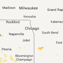
| 9:28 PM UTC | Golf Ball sized hail reported near Monticello, IA, 33.2 miles ENE of Cedar Rapids, IA, at least golfballs. hail 2 plus inches deep. hail broke visor on truck. |
| 9:40 PM UTC | Storm damage reported in iowa county IA, 36.1 miles WSW of Cedar Rapids, IA |
| 10:20 PM UTC | Downed power lines on 21st av in benton county IA, 21.5 miles W of Cedar Rapids, IA |
| 10:24 PM UTC | Quarter sized hail reported near Aurora, IA, 43.3 miles N of Cedar Rapids, IA, time estimated by radar... |
| 10:30 PM UTC | Roof blown off a bar in muscatine county IA, 35.3 miles SE of Cedar Rapids, IA |
| 10:35 PM UTC | Quarter sized hail reported near Iowa City, IA, 22.6 miles SSE of Cedar Rapids, IA, penny to quarter size hail reported. |
Illinois
| Local Time | Report Details |
|---|---|
| 7:45 PM UTC | Golf Ball sized hail reported near Prophetstown, IL, 69.2 miles NNW of Peoria, IL, hail started as pea sized and increased to golf ball size. altogether the hail lasted for about 20 minutes. |
| 10:00 AM UTC | Large tree limbs down in town. time estimate in morgan county IL, 74.6 miles SSW of Peoria, IL |
| 10:00 AM UTC | Large tree limbs blown down causing roof damage to a barn. tv antenna topple in morgan county IL, 65.1 miles N of Saint Louis, MO |
| 10:15 AM UTC | The tops of several 8 to 10-inch diameter trees were snapped off near 67 and old 36 just west of jacksonvill in morgan county IL, 75.1 miles SSW of Peoria, IL |
| 10:30 AM UTC | Power lines down and several uprooted trees in mason county IL, 43.5 miles SSW of Peoria, IL |
| 10:30 AM UTC | Large tree limbs and ham radio antenna blown down in cass county IL, 60.8 miles SSW of Peoria, IL |
| 10:30 AM UTC | Shed blown down and blocking road in cass county IL, 60.3 miles SSW of Peoria, IL |
| 10:41 AM UTC | About 1 mile stretch of power poles down on rt 104 between auburn and i55 in sangamon county IL, 70 miles NNE of Saint Louis, MO |
| 11:03 AM UTC | Large tree limbs down in sangamon county IL, 64.5 miles S of Peoria, IL |
| 11:15 AM UTC | Part of the roof blown off high school. power out for much of south side of delava in tazewell county IL, 22.4 miles S of Peoria, IL |
| 11:15 AM UTC | Windows blown out of a house...and a metal shed blown onto roa in tazewell county IL, 22.4 miles S of Peoria, IL |
Maryland
| Local Time | Report Details |
|---|---|
| 8:49 PM UTC | Quarter sized hail reported near Glenwood, MD, 22.5 miles W of Baltimore, MD |
| 8:49 PM UTC | Quarter sized hail reported near Woodbine, MD, 23.1 miles W of Baltimore, MD, hail was smaller than golfballs more near the size of quarters. |
Texas
| Local Time | Report Details |
|---|---|
| 9:15 PM UTC | Quarter sized hail reported near Strawn, TX, 72.8 miles E of Abilene, TX |
| 9:16 PM UTC | Quarter sized hail reported near Jacksboro, TX, 49.2 miles SSE of Wichita Falls, TX, 2n jacksboro near hwy 281 |
| 4:16 PM CDT | Quarter sized hail reported near Jacksboro, TX, 50.5 miles SSE of Wichita Falls, TX, reported west of jacksboro on hwy 380 |
| 9:17 PM UTC | Golf Ball sized hail reported near Jacksboro, TX, 51.1 miles SSE of Wichita Falls, TX |
| 9:18 PM UTC | Quarter sized hail reported near Wichita Falls, TX, 0.1 miles NNE of Wichita Falls, TX, loop 11 ans us 287 |
| 9:29 PM UTC | Quarter sized hail reported near Bryson, TX, 51.4 miles S of Wichita Falls, TX |
| 9:49 PM UTC | Quarter sized hail reported near Jacksboro, TX, 38.5 miles SE of Wichita Falls, TX |
| 9:58 PM UTC | Golf Ball sized hail reported near Millsap, TX, 71.3 miles W of Dallas, TX |
| 10:03 PM UTC | Quarter sized hail reported near Mineral Wells, TX, 76 miles W of Dallas, TX |
| 5:06 PM CDT | Baseball sized hail reported near Mineral Wells, TX, 75.9 miles W of Dallas, TX |
| 5:19 PM CDT | Baseball sized hail reported near Springtown, TX, 53.1 miles WNW of Dallas, TX |
| 10:40 PM UTC | Golf Ball sized hail reported near St Jo, TX, 57.7 miles ESE of Wichita Falls, TX |
| 10:53 PM UTC | Half Dollar sized hail reported near Springtown, TX, 49 miles WNW of Dallas, TX, hwy 730 |
| 10:55 PM UTC | Quarter sized hail reported near Reno, TX, 48 miles WNW of Dallas, TX, reported at hwy 199 and midway |
| 6:00 PM CDT | Ping Pong Ball sized hail reported near Springtown, TX, 50.3 miles WNW of Dallas, TX |
| 11:19 PM UTC | Golf Ball sized hail reported near Springtown, TX, 59.6 miles WNW of Dallas, TX, golfball hail in springtown |
| 11:25 PM UTC | Storm damage reported in montague county TX, 32.3 miles E of Wichita Falls, TX |
| 6:48 PM CDT | Golf Ball sized hail reported near Forestburg, TX, 59.6 miles ESE of Wichita Falls, TX |
| 11:50 PM UTC | Quarter sized hail reported near Muenster, TX, 61.9 miles NNW of Dallas, TX, quarter size hail south of muenster. |
| 6:50 PM CDT | Golf Ball sized hail reported near Fort Worth, TX, 32.3 miles WNW of Dallas, TX |
| 7:11 PM CDT | Golf Ball sized hail reported near Rosston, TX, 61.5 miles NW of Dallas, TX |
| 7:19 PM CDT | Storm damage reported in cooke county TX, 57.7 miles NNW of Dallas, TX |
| 7:20 PM CDT | Ping Pong Ball sized hail reported near Arlington, TX, 16.6 miles W of Dallas, TX |
| 7:20 PM CDT | Golf Ball sized hail reported near Springtown, TX, 53.1 miles WNW of Dallas, TX |
| 7:25 PM CDT | Golf Ball sized hail reported near Springtown, TX, 53.7 miles WNW of Dallas, TX |
| 7:27 PM CDT | Baseball sized hail reported near Springtown, TX, 53.7 miles WNW of Dallas, TX, baseball size hail north of springtown. |
| 12:28 AM UTC | Half Dollar sized hail reported near Gainesville, TX, 64.7 miles NNW of Dallas, TX |
| 7:30 PM CDT | Hen Egg sized hail reported near Haslet, TX, 34.9 miles WNW of Dallas, TX |
| 7:39 PM CDT | Quarter sized hail reported near Azle, TX, 43.6 miles WNW of Dallas, TX |
| 7:40 PM CDT | Golf Ball sized hail reported near Haslet, TX, 38.7 miles WNW of Dallas, TX |
| 7:42 PM CDT | Half Dollar sized hail reported near Haslet, TX, 34.9 miles WNW of Dallas, TX |
| 7:42 PM CDT | Grapefruit sized hail reported near Azle, TX, 46.7 miles WNW of Dallas, TX |
| 7:46 PM CDT | Tennis Ball sized hail reported near Haslet, TX, 38.7 miles WNW of Dallas, TX |
| 12:50 AM UTC | Trees down and shingles blown off apartment building roof in tarrant county TX, 35.7 miles W of Dallas, TX |
| 7:54 PM CDT | Golf Ball sized hail reported near Haslet, TX, 38.7 miles WNW of Dallas, TX |
| 7:55 PM CDT | Tennis Ball sized hail reported near Fort Worth, TX, 29.5 miles WNW of Dallas, TX |
| 7:55 PM CDT | Grapefruit sized hail reported near Haslet, TX, 38.7 miles WNW of Dallas, TX |
| 1:00 AM UTC | Several large trees either d in tarrant county TX, 25.5 miles W of Dallas, TX |
| 8:00 PM CDT | Multiple trees down & shingles torn from roof in denton county TX, 32.5 miles NW of Dallas, TX |
| 8:00 PM CDT | Golf Ball sized hail reported near Irving, TX, 8.1 miles WNW of Dallas, TX, golfball size hail at intersection of hwy 114 and macarthur blvd. |
| 1:01 AM UTC | Extensive house damage in tarrant county TX, 34 miles W of Dallas, TX |
| 8:02 PM CDT | Golf Ball sized hail reported near Grapevine, TX, 19.6 miles WNW of Dallas, TX, golfball size hail reported in grapevine |
| 8:10 PM CDT | Golf Ball sized hail reported near Grapevine, TX, 19.4 miles NW of Dallas, TX, golfball hail in grap |
| 1:11 AM UTC | Interstate 820 and hwy 377 in tarrant county TX, 31.8 miles W of Dallas, TX |
| 8:14 PM CDT | Quarter sized hail reported near Dfw Airport, TX, 17.6 miles NW of Dallas, TX |
| 8:15 PM CDT | Tennis Ball sized hail reported near Fort Worth, TX, 30.3 miles WNW of Dallas, TX, nw side of keller between hwy 170 and golden triangle blvd. |
| 8:19 PM CDT | Golf Ball sized hail reported near Bedford, TX, 20.1 miles WNW of Dallas, TX |
| 8:19 PM CDT | Golf Ball sized hail reported near Fort Worth, TX, 38.1 miles W of Dallas, TX |
| 8:20 PM CDT | Grapefruit sized hail reported near Irving, TX, 7.8 miles WNW of Dallas, TX |
| 8:22 PM CDT | Golf Ball sized hail reported near Keller, TX, 28.4 miles WNW of Dallas, TX |
| 8:22 PM CDT | Baseball sized hail reported near Sherman, TX, 58 miles SSW of Atoka, OK |
| 8:25 PM CDT | Ping Pong Ball sized hail reported near Irving, TX, 7.8 miles WNW of Dallas, TX, ping pong size hail in irving. |
| 8:27 PM CDT | Tennis Ball sized hail reported near Dallas, TX, 1.1 miles ESE of Dallas, TX, 116 chesterfield circle dallas |
| 8:28 PM CDT | Golf Ball sized hail reported near Dfw Airport, TX, 17.6 miles NW of Dallas, TX |
| 8:28 PM CDT | Grapefruit sized hail reported near Fort Worth, TX, 29.2 miles WNW of Dallas, TX, softball size hail with estimated 70 mph winds nw side of k |
| 8:30 PM CDT | Estimated 70 mph winds knocked down two very large trees just se of e loop 820 and i-30 intersectio in tarrant county TX, 26 miles W of Dallas, TX |
| 8:33 PM CDT | Golf Ball sized hail reported near Cedar Hill, TX, 16.4 miles SSW of Dallas, TX, at 183 and mockingbird |
| 8:35 PM CDT | Golf Ball sized hail reported near Farmers Branch, TX, 12.1 miles NNW of Dallas, TX |
| 8:49 PM CDT | Baseball sized hail reported near Dallas, TX, 1.1 miles ESE of Dallas, TX, skillman & southwestern |
| 9:01 PM CDT | Golf Ball sized hail reported near Gainesville, TX, 62.2 miles NNW of Dallas, TX |
| 9:01 PM CDT | Baseball sized hail reported near Fort Worth, TX, 31.8 miles W of Dallas, TX |
| 9:02 PM CDT | Golf Ball sized hail reported near Arlington, TX, 19.2 miles W of Dallas, TX, i-20 and bowen |
| 9:02 PM CDT | Golf Ball sized hail reported near Fort Worth, TX, 30.6 miles W of Dallas, TX, i-30 and beach |
| 9:03 PM CDT | Golf Ball sized hail reported near Fort Worth, TX, 31.8 miles W of Dallas, TX |
| 2:04 AM UTC | 70-85 mph wind in cooke county TX, 54.9 miles NNW of Dallas, TX |
| 9:05 PM CDT | Baseball sized hail reported near Arlington, TX, 19.2 miles W of Dallas, TX, i-20 and bowen |
| 2:08 AM UTC | Golf Ball sized hail reported near Whitesboro, TX, 58.8 miles N of Dallas, TX |
| 9:19 PM CDT | Golf Ball sized hail reported near Arlington, TX, 19.2 miles W of Dallas, TX |
| 9:20 PM CDT | Quarter sized hail reported near Arlington, TX, 16.6 miles W of Dallas, TX, 2 s euless penny to quarter size hail |
| 9:20 PM CDT | Golf Ball sized hail reported near Arlington, TX, 19.2 miles W of Dallas, TX |
| 9:20 PM CDT | Golf Ball sized hail reported near Fort Worth, TX, 16.8 miles W of Dallas, TX |
| 9:27 PM CDT | Quarter sized hail reported near Whitesboro, TX, 60.2 miles N of Dallas, TX |
| 2:29 AM UTC | Quarter sized hail reported near Valley View, TX, 47.4 miles NNW of Dallas, TX |
| 9:30 PM CDT | Ping Pong Ball sized hail reported near Dallas, TX, 1.1 miles ESE of Dallas, TX, near downtown dallas. |
| 9:30 PM CDT | Very large tree branches broken and wood fence blown down. one inch hail occurred as wel in dallas county TX, 2.1 miles ESE of Dallas, TX |
| 9:34 PM CDT | Storm damage reported in tarrant county TX, 19.2 miles W of Dallas, TX |
| 9:37 PM CDT | Quarter sized hail reported near Sherman, TX, 58.6 miles SSW of Atoka, OK |
| 2:38 AM UTC | Storm damage reported in grayson county TX, 58 miles SSW of Atoka, OK |
| 9:40 PM CDT | Golf Ball sized hail reported near Sherman, TX, 57.5 miles SSW of Atoka, OK |
| 9:42 PM CDT | Quarter sized hail reported near Fort Worth, TX, 41.5 miles WNW of Dallas, TX |
| 9:45 PM CDT | Golf Ball sized hail reported near Haslet, TX, 38.7 miles WNW of Dallas, TX |
| 9:48 PM CDT | Quarter sized hail reported near Justin, TX, 37.2 miles NW of Dallas, TX |
| 9:48 PM CDT | Hen Egg sized hail reported near Celina, TX, 37.3 miles N of Dallas, TX, large limbs down |
| 9:50 PM CDT | Storm damage reported in tarrant county TX, 19.2 miles W of Dallas, TX |
| 9:50 PM CDT | Quarter sized hail reported near Argyle, TX, 32.5 miles NW of Dallas, TX |
| 10:00 PM CDT | Storm damage reported in denton county TX, 30.2 miles NNW of Dallas, TX |
| 10:11 PM CDT | Baseball sized hail reported near Crandall, TX, 22.9 miles ESE of Dallas, TX, just s of crandall baseball hail |
| 10:13 PM CDT | Large tree approx 2-4 ft wide lying in road at beltline in dallas county TX, 14.6 miles SSE of Dallas, TX |
| 10:23 PM CDT | Quarter sized hail reported near Euless, TX, 16.9 miles WNW of Dallas, TX |
| 10:23 PM CDT | Golf Ball sized hail reported near Kaufman, TX, 26.3 miles ESE of Dallas, TX |
| 10:24 PM CDT | Baseball sized hail reported near Kaufman, TX, 30.6 miles ESE of Dallas, TX |
| 10:25 PM CDT | Storm damage reported in collin county TX, 17.2 miles NNE of Dallas, TX |
| 10:33 PM CDT | Estimated wind gust 65 mph with sheets of rain in dallas county TX, 12.6 miles NNE of Dallas, TX |
| 3:37 AM UTC | 62 mph measured wind power flashes and power outages in collin county TX, 26.8 miles NE of Dallas, TX |
| 10:40 PM CDT | Large trees down in highland par in dallas county TX, 3.2 miles NNE of Dallas, TX |
| 3:40 AM UTC | Quarter sized hail reported near Joshua, TX, 38.9 miles SW of Dallas, TX |
| 3:40 AM UTC | Ping Pong Ball sized hail reported near Cleburne, TX, 46 miles SW of Dallas, TX, hail 3/4 inch short bursts lasted less 2 min |
| 11:17 PM CDT | Hwy 243 and hwy 175 in kaufman county TX, 30.9 miles ESE of Dallas, TX |
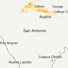
| 4:34 AM UTC | Quarter sized hail reported near San Saba, TX, 59.1 miles W of Killeen, TX |
| 7:11 AM UTC | Quarter sized hail reported near , , 24 miles SW of Killeen, TX |
| 7:54 AM UTC | Quarter sized hail reported near Jarrell, TX, 23.7 miles SSE of Killeen, TX |
| 4:15 AM CDT | Golf Ball sized hail reported near Taylor, TX, 42.9 miles SSE of Killeen, TX, media relayed report from the public of golf ball size hail near taylor. |
| 5:05 AM CDT | Quarter sized hail reported near Austin, TX, 52.1 miles S of Killeen, TX |
| 5:07 AM CDT | Ping Pong Ball sized hail reported near Austin, TX, 52.1 miles S of Killeen, TX, quarter to half dollar size hail |
Wyoming
| Local Time | Report Details |
|---|---|
| 9:57 PM UTC | Quarter sized hail reported near Rozet, WY, 11.9 miles ENE of Gillette, WY |
Indiana
| Local Time | Report Details |
|---|---|
| 11:04 PM UTC | Quarter sized hail reported near Marion, IN, 50.6 miles SW of Fort Wayne, IN |
| 11:11 PM UTC | Golf Ball sized hail reported near Marion, IN, 50.6 miles SW of Fort Wayne, IN, small limbs down |
| 4:25 AM UTC | Golf Ball sized hail reported near Francesville, IN, 76.5 miles SSE of Chicago, IL, hail up to golf ball size...lasted for 15 min |
Arkansas
| Local Time | Report Details |
|---|---|
| 4:20 AM UTC | Quarter sized hail reported near Huntington, AR, 22.9 miles SSE of Fort Smith, AR |
| 4:30 AM UTC | At fianna hills..power outages...numerous small trees broken. several large tree limbs broke in sebastian county AR, 1.3 miles ENE of Fort Smith, AR |
| 4:40 AM UTC | Storm damage reported in sebastian county AR, 7.8 miles ESE of Fort Smith, AR |
| 4:40 AM UTC | Structural house damage. house siding blown off. two windows blown out. barn damaged. possible tornad in crawford county AR, 4.5 miles N of Fort Smith, AR |
| 5:00 AM UTC | Houses detroyed in me in franklin county AR, 30 miles E of Fort Smith, AR |
| 5:05 AM UTC | Storm damage reported in crawford county AR, 18.4 miles N of Fort Smith, AR |
| 5:15 AM UTC | Storm damage reported in washington county AR, 48.3 miles NNE of Fort Smith, AR |
| 5:20 AM UTC | 4 ft tree snapped in franklin county AR, 37.4 miles E of Fort Smith, AR |
| 5:20 AM UTC | Quarter sized hail reported near Hartman, AR, 42.9 miles E of Fort Smith, AR |
| 5:29 AM UTC | Houses damaged in clarksvill in johnson county AR, 53.9 miles E of Fort Smith, AR |
| 5:42 AM UTC | Quarter sized hail reported near Clarksville, AR, 53.9 miles E of Fort Smith, AR |
Connect with Interactive Hail Maps