

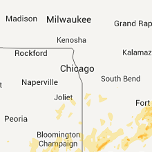
Hail Map for Wednesday, May 25, 2011

Number of Impacted Households on 5/25/2011
0
Impacted by 1" or Larger Hail
0
Impacted by 1.75" or Larger Hail
0
Impacted by 2.5" or Larger Hail
Square Miles of Populated Area Impacted on 5/25/2011
0
Impacted by 1" or Larger Hail
0
Impacted by 1.75" or Larger Hail
0
Impacted by 2.5" or Larger Hail


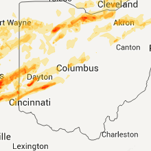


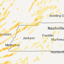


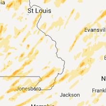


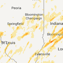


Cities Most Affected by Hail Storms of 5/25/2011
| Hail Size | Demographics of Zip Codes Affected | ||||||
|---|---|---|---|---|---|---|---|
| City | Count | Average | Largest | Pop Density | House Value | Income | Age |
| Saint Louis, MO | 10 | 2.88 | 4.50 | 3445 | $150k | $41.3k | 38.9 |
| Dayton, OH | 6 | 2.04 | 3.00 | 1785 | $161k | $63.8k | 45.9 |
| Xenia, OH | 6 | 2.04 | 2.75 | 272 | $91k | $41.4k | 40.9 |
| Cleveland, TX | 4 | 2.94 | 4.00 | 83 | $15k | $9.0k | 35.4 |
| Bedford, IN | 4 | 2.69 | 2.75 | 152 | $76k | $35.9k | 41.9 |
| Greensburg, IN | 4 | 2.63 | 4.00 | 73 | $89k | $40.0k | 38.8 |
| Bellbrook, OH | 4 | 2.25 | 3.00 | 764 | $141k | $63.1k | 40.1 |
| Morrisville, MO | 4 | 2.13 | 3.00 | 40 | $65k | $33.8k | 39.7 |
| Ellington, MO | 4 | 1.75 | 1.75 | 8 | $45k | $26.9k | 43.2 |
| Ash Grove, MO | 3 | 2.17 | 2.75 | 43 | $77k | $35.8k | 42.9 |
| Greenville, OH | 3 | 1.75 | 1.75 | 154 | $92k | $36.8k | 43.4 |
| Walnut Grove, MO | 2 | 2.25 | 2.75 | 30 | $62k | $34.5k | 41.0 |
| Pineville, LA | 2 | 2.25 | 2.50 | 181 | $80k | $32.7k | 36.4 |
| Straughn, IN | 1 | 4.25 | 4.25 | 27 | $75k | $51.7k | 42.4 |
| Odon, IN | 2 | 2.13 | 2.50 | 68 | $70k | $38.5k | 33.3 |
| Greenwood, IN | 2 | 1.88 | 2.00 | 1317 | $137k | $56.0k | 37.1 |
| Findlay, OH | 2 | 1.88 | 2.00 | 333 | $108k | $43.8k | 37.6 |
| Climax Springs, MO | 2 | 1.75 | 1.75 | 31 | $128k | $36.7k | 56.8 |
| Cave City, AR | 2 | 1.75 | 1.75 | 34 | $53k | $30.2k | 39.9 |
| Bauxite, AR | 2 | 1.75 | 1.75 | 78 | $83k | $39.2k | 36.0 |
| Potosi, MO | 2 | 1.75 | 1.75 | 30 | $63k | $26.0k | 39.4 |
| Montgomery City, MO | 2 | 1.75 | 1.75 | 29 | $65k | $33.3k | 40.8 |
| Bronson, TX | 2 | 1.75 | 1.75 | 13 | $40k | $28.9k | 45.1 |
| Gosport, IN | 2 | 1.75 | 1.75 | 44 | $90k | $39.0k | 41.5 |
| Huntsville, TX | 2 | 1.75 | 1.75 | 96 | $81k | $31.6k | 32.8 |
| Olean, MO | 2 | 1.75 | 1.75 | 28 | $68k | $32.5k | 42.3 |
| Fostoria, OH | 2 | 1.75 | 1.75 | 161 | $70k | $33.3k | 39.8 |
| Columbus, IN | 2 | 1.75 | 1.75 | 211 | $97k | $41.4k | 36.5 |
| Brookville, IN | 1 | 3.00 | 3.00 | 63 | $95k | $40.8k | 39.8 |
| Sheridan, TX | 1 | 2.75 | 2.75 | 0 | $50k | $24.8k | 44.3 |
| De Soto, MO | 1 | 2.75 | 2.75 | 149 | $83k | $38.9k | 39.1 |
| Bellevue, OH | 1 | 2.75 | 2.75 | 110 | $93k | $42.9k | 38.8 |
| Whiteland, IN | 1 | 2.75 | 2.75 | 595 | $96k | $54.2k | 35.3 |
| Ganado, TX | 1 | 2.50 | 2.50 | 8 | $54k | $35.3k | 38.3 |
| Deville, LA | 1 | 2.50 | 2.50 | 64 | $76k | $35.8k | 37.2 |
| Miamisburg, OH | 1 | 2.50 | 2.50 | 1089 | $118k | $46.0k | 37.1 |
| Clyde, OH | 1 | 2.50 | 2.50 | 202 | $87k | $40.2k | 39.4 |
| Newark, AR | 1 | 2.00 | 2.00 | 25 | $54k | $30.9k | 39.3 |
| Lewisville, IN | 1 | 2.00 | 2.00 | 22 | $84k | $52.5k | 43.2 |
| Indianapolis, IN | 1 | 2.00 | 2.00 | 2706 | $112k | $54.2k | 34.4 |
| Rison, AR | 1 | 2.00 | 2.00 | 19 | $53k | $34.1k | 39.5 |
| Bloomfield, IN | 1 | 1.75 | 1.75 | 52 | $75k | $36.9k | 41.4 |
| Marion, LA | 1 | 1.75 | 1.75 | 11 | $51k | $26.3k | 42.7 |
| Widener, AR | 1 | 1.75 | 1.75 | 5 | $29k | $20.9k | 43.4 |
| Seymour, IL | 1 | 1.75 | 1.75 | 15 | $119k | $68.8k | 41.3 |
| Doniphan, MO | 1 | 1.75 | 1.75 | 21 | $50k | $22.3k | 41.7 |
| Barnett, MO | 1 | 1.75 | 1.75 | 32 | $68k | $34.1k | 35.0 |
| Granite City, IL | 1 | 1.75 | 1.75 | 979 | $62k | $37.1k | 38.8 |
| Cadet, MO | 1 | 1.75 | 1.75 | 68 | $50k | $27.6k | 36.8 |
| White Hall, AR | 1 | 1.75 | 1.75 | 157 | $65k | $34.4k | 38.8 |
| West Alexandria, OH | 1 | 1.75 | 1.75 | 113 | $95k | $44.2k | 41.4 |
| Green Springs, OH | 1 | 1.75 | 1.75 | 60 | $86k | $40.7k | 41.0 |
| Cole Camp, MO | 1 | 1.75 | 1.75 | 18 | $66k | $29.5k | 44.3 |
| Lafayette, IN | 1 | 1.75 | 1.75 | 336 | $118k | $45.3k | 36.4 |
| Cedarville, OH | 1 | 1.75 | 1.75 | 55 | $120k | $42.5k | 21.7 |
| Middletown, OH | 1 | 1.75 | 1.75 | 536 | $111k | $45.0k | 42.2 |
| Winnie, TX | 1 | 1.75 | 1.75 | 29 | $58k | $35.4k | 37.3 |
| Natchitoches, LA | 1 | 1.75 | 1.75 | 100 | $78k | $25.9k | 30.3 |
| Ravenna, OH | 1 | 1.75 | 1.75 | 370 | $107k | $41.6k | 40.8 |
| Republic, OH | 1 | 1.75 | 1.75 | 29 | $89k | $40.0k | 39.1 |
| Paris, IL | 1 | 1.75 | 1.75 | 47 | $56k | $35.0k | 42.9 |
| Grovespring, MO | 1 | 1.75 | 1.75 | 17 | $46k | $29.1k | 42.2 |
| Union City, TN | 1 | 1.75 | 1.75 | 90 | $75k | $33.9k | 40.6 |
| Blessing, TX | 1 | 1.75 | 1.75 | 0 | $55k | $27.1k | 33.0 |
| Amo, IN | 1 | 1.75 | 1.75 | 0 | $81k | $41.8k | 36.5 |
| Salem, MO | 1 | 1.75 | 1.75 | 21 | $63k | $27.0k | 42.8 |
| Giddings, TX | 1 | 1.75 | 1.75 | 40 | $73k | $35.4k | 35.6 |
| La Grange, TX | 1 | 1.75 | 1.75 | 40 | $80k | $37.2k | 45.0 |
| Lohman, MO | 1 | 1.75 | 1.75 | 40 | $131k | $49.8k | 43.8 |
| Hiram, OH | 1 | 1.75 | 1.75 | 106 | $139k | $51.3k | 34.9 |
| Arnold, MO | 1 | 1.75 | 1.75 | 1657 | $103k | $50.6k | 38.2 |
| Blackwell, MO | 1 | 1.75 | 1.75 | 64 | $10k | $40.2k | 37.7 |
| Bloomville, OH | 1 | 1.75 | 1.75 | 27 | $82k | $40.9k | 39.5 |
| Sandusky, OH | 1 | 1.75 | 1.75 | 734 | $90k | $36.0k | 41.3 |
| Lilbourn, MO | 1 | 1.75 | 1.75 | 4 | $42k | $24.5k | 40.7 |
| Mill Spring, MO | 1 | 1.75 | 1.75 | 4 | $18k | $26.1k | 42.3 |
| Delphi, IN | 1 | 1.75 | 1.75 | 60 | $86k | $44.6k | 40.2 |
| Warren, OH | 1 | 1.75 | 1.75 | 1402 | $77k | $33.9k | 42.2 |
| Hope, IN | 1 | 1.75 | 1.75 | 74 | $87k | $42.2k | 39.6 |
| Columbus, TX | 1 | 1.75 | 1.75 | 34 | $83k | $36.1k | 43.9 |
| Fort Wayne, IN | 1 | 1.75 | 1.75 | 786 | $246k | $112.3k | 38.7 |
| Roanoke, IN | 1 | 1.75 | 1.75 | 98 | $114k | $50.6k | 41.2 |
| Clayton, OH | 1 | 1.75 | 1.75 | 451 | $139k | $52.7k | 43.4 |
| Ravenden, AR | 1 | 1.75 | 1.75 | 12 | $40k | $24.1k | 47.4 |
| Spiceland, IN | 1 | 1.75 | 1.75 | 53 | $83k | $46.9k | 40.7 |
| San Augustine, TX | 1 | 1.75 | 1.75 | 17 | $53k | $26.6k | 45.2 |
| Smithville, AR | 1 | 1.75 | 1.75 | 10 | $52k | $30.1k | 45.2 |
| Ramsey, IL | 1 | 1.75 | 1.75 | 18 | $49k | $29.7k | 40.6 |
| Garwood, TX | 1 | 1.75 | 1.75 | 3 | $60k | $29.8k | 45.0 |
| Schulenburg, TX | 1 | 1.75 | 1.75 | 31 | $63k | $33.8k | 46.3 |
| New Castle, IN | 1 | 1.75 | 1.75 | 191 | $81k | $36.6k | 41.3 |
| Gas City, IN | 1 | 1.75 | 1.75 | 596 | $66k | $36.3k | 39.9 |
| Yorktown, AR | 1 | 1.75 | 1.75 | 0 | $0k | $0.0k | 0.0 |
| Farmerville, LA | 1 | 1.75 | 1.75 | 53 | $70k | $30.1k | 39.8 |
| Owensburg, IN | 1 | 1.75 | 1.75 | 24 | $59k | $27.2k | 39.5 |
| Couch, MO | 1 | 1.75 | 1.75 | 8 | $19k | $23.0k | 50.6 |
| Brookville, OH | 1 | 1.75 | 1.75 | 182 | $115k | $44.8k | 44.4 |
| Stinesville, IN | 1 | 1.75 | 1.75 | 0 | $47k | $37.5k | 45.8 |
| Englewood, OH | 1 | 1.75 | 1.75 | 1089 | $107k | $49.8k | 41.4 |
| Coushatta, LA | 1 | 1.75 | 1.75 | 24 | $49k | $23.4k | 38.5 |
| Imboden, AR | 1 | 1.75 | 1.75 | 20 | $49k | $24.7k | 41.6 |
| College Corner, OH | 1 | 1.75 | 1.75 | 68 | $84k | $36.5k | 40.2 |
| Ellis Grove, IL | 1 | 1.75 | 1.75 | 26 | $56k | $41.0k | 42.4 |
| Lake Village, AR | 1 | 1.75 | 1.75 | 15 | $81k | $28.2k | 44.0 |
| Cambridge City, IN | 1 | 1.75 | 1.75 | 78 | $79k | $34.8k | 40.8 |
| Burlington, IN | 1 | 1.75 | 1.75 | 67 | $0k | $0.0k | 41.3 |
| Gunnison, MS | 1 | 1.75 | 1.75 | 3 | $40k | $20.1k | 31.3 |
| Lebanon, MO | 1 | 1.75 | 1.75 | 73 | $75k | $30.1k | 38.8 |
| Plain City, OH | 1 | 1.75 | 1.75 | 123 | $141k | $50.9k | 39.0 |
Hail and Wind Damage Spotted on 5/25/2011
Filter by Report Type:Hail ReportsWind Reports
States Impacted
Illinois, Indiana, Missouri, Mississippi, Ohio, Arkansas, Iowa, Texas, Louisiana, Tennessee, Kentucky, Pennsylvania, New York, California, Alabama, South CarolinaIllinois
| Local Time | Report Details |
|---|---|
| 12:40 PM UTC | Several farm outbuildings destroyed. time estimate in piatt county IL, 39.7 miles NNW of Mattoon, IL |
| 12:45 PM UTC | 2 outbuildings and 1 grain bin destroyed. from macon county emergency managemen in macon county IL, 36 miles NW of Mattoon, IL |
| 1:00 PM UTC | Tree down on railroad tracks in douglas county IL, 21.2 miles NNE of Mattoon, IL |
| 1:08 PM UTC | Trees down from county em in champaign county IL, 33.7 miles N of Mattoon, IL |
| 1:10 PM UTC | Old flat roof barn blown of in champaign county IL, 30.1 miles N of Mattoon, IL |
| 1:10 PM UTC | Semi blown over on i-57 at mm 220 in champaign county IL, 30.1 miles N of Mattoon, IL |
| 1:10 PM UTC | Semi blown over on i-57. one injur in champaign county IL, 29.4 miles N of Mattoon, IL |
| 1:15 PM UTC | Powerlines and power poles down in champaign county IL, 44.2 miles NNE of Mattoon, IL |
| 1:17 PM UTC | Powerlines down in champaign county IL, 42.3 miles NNE of Mattoon, IL |
| 1:20 PM UTC | 7 power poles down in douglas county IL, 33.2 miles NE of Mattoon, IL |
| 1:29 PM UTC | 2 semis blown over on i-74 between mm 194 and 19 in champaign county IL, 49.1 miles NNE of Mattoon, IL |
| 1:36 PM UTC | Numerous trees and powerlines down in vermilion county IL, 72.1 miles NNE of Mattoon, IL |
| 1:40 PM UTC | Trees down and siding off a house in vermilion county IL, 50.5 miles NNE of Mattoon, IL |
| 1:55 PM UTC | Storm damage reported in vermilion county IL, 77.8 miles NNE of Mattoon, IL |
| 1:57 PM UTC | Trees and powerlines down in vermilion county IL, 60.5 miles NE of Mattoon, IL |
| 1:58 PM UTC | Power lines down on the east side of danvill in vermilion county IL, 61.4 miles NE of Mattoon, IL |
| 5:57 PM UTC | Golf Ball sized hail reported near Ramsey, IL, 45.9 miles WSW of Mattoon, IL |
| 6:46 PM UTC | Quarter sized hail reported near Windsor, IL, 14.7 miles W of Mattoon, IL |
| 6:47 PM UTC | Quarter sized hail reported near Stewardson, IL, 19.5 miles SW of Mattoon, IL |
| 8:05 PM UTC | Quarter sized hail reported near Taylor Springs, IL, 51.2 miles NE of Saint Louis, MO |
| 8:45 PM UTC | 3-inch limbs were down with pea-size hai in bond county IL, 46.8 miles ENE of Saint Louis, MO |
| 8:55 PM UTC | Ping Pong Ball sized hail reported near Bunker Hill, IL, 34 miles NNE of Saint Louis, MO, near intersection of hwy 138 and 159 |
| 9:03 PM UTC | Ping Pong Ball sized hail reported near Carlinville, IL, 47.5 miles NNE of Saint Louis, MO |
| 9:10 PM UTC | Quarter sized hail reported near Winchester, IL, 70.8 miles NNW of Saint Louis, MO |
| 9:10 PM UTC | Tree limbs...trees...power poles and power lines blown dow in scott county IL, 70.5 miles NNW of Saint Louis, MO |
| 9:15 PM UTC | Quarter sized hail reported near Carlinville, IL, 47.9 miles NNE of Saint Louis, MO, 1 inch hail on route 4. |
| 9:18 PM UTC | Storage shed destroye in scott county IL, 76.6 miles NNW of Saint Louis, MO |
| 9:35 PM UTC | Trees and power lines down reported by cass county sheriff office in cass county IL, 64.7 miles SW of Peoria, IL |
| 9:38 PM UTC | Quarter sized hail reported near Granite City, IL, 6.8 miles NNE of Saint Louis, MO |
| 9:42 PM UTC | Quarter sized hail reported near Granite City, IL, 6.8 miles NNE of Saint Louis, MO, at the corner of lynch and vine avenues. |
| 9:45 PM UTC | Trees and powerlines blown down in schuyler county IL, 56.6 miles SW of Peoria, IL |
| 9:45 PM UTC | Tree fell on house on kenny street in tow in sangamon county IL, 68.3 miles W of Mattoon, IL |
| 9:56 PM UTC | Golf Ball sized hail reported near Granite City, IL, 6.8 miles NNE of Saint Louis, MO |
| 10:00 PM UTC | Trees down and power out. time estimate in montgomery county IL, 59.7 miles NNE of Saint Louis, MO |
| 10:03 PM UTC | Quarter sized hail reported near Freeburg, IL, 20.8 miles SE of Saint Louis, MO, also a wind gust to 47 mph. |
| 10:05 PM UTC | Ping Pong Ball sized hail reported near Freeburg, IL, 20.8 miles SE of Saint Louis, MO |
| 10:05 PM UTC | Storm damage reported in st. clair county IL, 20.8 miles SE of Saint Louis, MO |
| 10:07 PM UTC | Half Dollar sized hail reported near Mechanicsburg, IL, 59.1 miles WNW of Mattoon, IL |
| 10:08 PM UTC | Storm damage reported in madison county IL, 17.3 miles NNE of Saint Louis, MO |
| 10:12 PM UTC | Quarter sized hail reported near Mascoutah, IL, 22.6 miles ESE of Saint Louis, MO |
| 10:19 PM UTC | Golf Ball sized hail reported near Paris, IL, 37.9 miles ENE of Mattoon, IL |
| 10:20 PM UTC | Tree fell on a hous in sangamon county IL, 68.3 miles W of Mattoon, IL |
| 10:21 PM UTC | 2-3 inch limbs down in madison county IL, 29.1 miles ENE of Saint Louis, MO |
| 10:21 PM UTC | Numerous trees and power lines down. power out in most of the tow in st clair county IL, 49 miles SSE of Columbia, MO |
| 10:25 PM UTC | Golf Ball sized hail reported near Ellis Grove, IL, 44.8 miles SSE of Saint Louis, MO, hail increased from nickel size to golf ball size. |
| 10:25 PM UTC | Trees down in town in mason county IL, 25.6 miles SSW of Peoria, IL |
| 10:25 PM UTC | Large tree limb broken off...one foot in diameter...in lincoln on 5th street. from two nws employee in logan county IL, 39.1 miles SSE of Peoria, IL |
| 10:25 PM UTC | Major structural damage to popcorn factory in mason county IL, 27.4 miles SSW of Peoria, IL |
| 10:28 PM UTC | Storm damage reported in logan county IL, 47.6 miles SSE of Peoria, IL |
| 10:28 PM UTC | Tree topped at wfo lincoln in logan county IL, 39.8 miles SSE of Peoria, IL |
| 10:30 PM UTC | Powerline blown dow in menard county IL, 54.5 miles SSW of Peoria, IL |
| 10:40 PM UTC | 6-7 inch diameter tree snapped of at the base causing some roof damage in warren county IL, 57.2 miles WNW of Peoria, IL |
| 10:40 PM UTC | Tree down. snapped of at the bas in warren county IL, 57.2 miles WNW of Peoria, IL |
| 10:42 PM UTC | Numerous reports of trees and tree limbs down. shed blown off foundation at 309 part street. 4 foot tree fell on house. from damage summary sheet from peoria county eme in peoria county IL, 14.4 miles SW of Peoria, IL |
| 10:42 PM UTC | Numerous large trees down...power out. minor road flooding as well. time is approximat in bond county IL, 46.8 miles ENE of Saint Louis, MO |
| 10:46 PM UTC | Large limbs blown down and a fence blown down. west of bartonville at the corner of oak grove road and smithville road...4 miles south of trivoli. from damage summary s in peoria county IL, 15.9 miles WSW of Peoria, IL |
| 10:49 PM UTC | Storm damage reported in warren county IL, 58.4 miles WNW of Peoria, IL |
| 10:49 PM UTC | Numerous branches and limbs over streets...some as large as 6 to 8 inches in diamete in montgomery county IL, 50.5 miles WSW of Mattoon, IL |
| 10:50 PM UTC | Storm damage reported in knox county IL, 43.5 miles WNW of Peoria, IL |
| 10:50 PM UTC | Trees and power lines down in bond county IL, 46.8 miles ENE of Saint Louis, MO |
| 10:50 PM UTC | Power lines down in bond county IL, 49.8 miles ENE of Saint Louis, MO |
| 10:51 PM UTC | Recorded at peoria airport in peoria county IL, 3.5 miles NNW of Peoria, IL |
| 5:52 PM CDT | Wind gust estimated near lamp road in tazewell county IL, 7.6 miles SE of Peoria, IL |
| 10:52 PM UTC | Numerous trees and power lines blown down at numerous locations across the city of peoria. many traffic lights out. time of occurance was between 552 pm and 605 pm. fro in peoria county IL, 3.5 miles NNW of Peoria, IL |
| 10:55 PM UTC | 10 inch tree blown down blocking road...14305 n. edgewater drive. from damage summary sheet from peoria county emergency managemen in peoria county IL, 6 miles NW of Peoria, IL |
| 5:55 PM CDT | Tree blown down blocking road...3 miles south of edwards...near corner of route 8 and heinz lane. from damage summary sheet from peoria county emergency management offi in peoria county IL, 9.2 miles NW of Peoria, IL |
| 5:57 PM CDT | Trees blown down on the kickapoo edwards blacktop...south of route 150 by about one 10th of a mile. from peoria county emergency management damage summary shee in peoria county IL, 11.3 miles NW of Peoria, IL |
| 10:57 PM UTC | Quarter sized hail reported near Centralia, IL, 58.4 miles E of Saint Louis, MO |
| 10:58 PM UTC | Utility poles blown over on the east side of cheste in randolph county IL, 45.4 miles NNW of Cape Girardeau, MO |
| 11:00 PM UTC | Numerous branches and limbs over streets...some as large as 6 to 8 inches in diamete in montgomery county IL, 50.5 miles WSW of Mattoon, IL |
| 11:02 PM UTC | 10 inch tree limb snapped off live maple tree approximately 8 feet above ground in tazewell county IL, 2.5 miles SE of Peoria, IL |
| 11:05 PM UTC | 3 inch diameter tree branch blown down in tazewell county IL, 8.7 miles SSW of Peoria, IL |
| 11:07 PM UTC | Quarter sized hail reported near Rio, IL, 51.4 miles NW of Peoria, IL |
| 11:08 PM UTC | Update report from em...event occurred between eddyville and glendale illinois. large trees down. power outages along state hwy 147. partial roof removed on home and ba in pope county IL, 54.2 miles ENE of Cape Girardeau, MO |
| 11:08 PM UTC | Trees down along route 3 between rockwood and cheste in randolph county IL, 38 miles NNW of Cape Girardeau, MO |
| 11:09 PM UTC | Storm damage reported in knox county IL, 51.4 miles NW of Peoria, IL |
| 11:11 PM UTC | Tree and power poles snapped off in mclean county IL, 49.9 miles ESE of Peoria, IL |
| 11:12 PM UTC | Quarter sized hail reported near Magnolia, IL, 35.3 miles NNE of Peoria, IL |
| 11:13 PM UTC | Semi blown over at i-74 mile marker 145 in mclean county IL, 45.7 miles ESE of Peoria, IL |
| 11:15 PM UTC | Delayed report. power poles down and part of a machine shed blown apart. time estimate in shelby county IL, 11.3 miles WSW of Mattoon, IL |
| 11:18 PM UTC | Tree blown down along us-150. time estimate in knox county IL, 39.8 miles WNW of Peoria, IL |
| 11:19 PM UTC | Outbuildings damaged at lowes. large vent torn off roof at a s in knox county IL, 45.2 miles WNW of Peoria, IL |
| 11:19 PM UTC | Outbuildings damaged at lowes. shed blown over at the catholic school. time estimate in knox county IL, 45.2 miles WNW of Peoria, IL |
| 11:25 PM UTC | Quarter sized hail reported near Pesotum, IL, 30.1 miles N of Mattoon, IL |
| 11:30 PM UTC | Some small to medium tree limbs down...and a few power lines dow in effingham county IL, 26.6 miles SSW of Mattoon, IL |
| 11:30 PM UTC | Some shingles blown off a house roof...doors blown off an outbuilding...and 10 inch diameter tree limbs down. time estimate in shelby county IL, 16.8 miles WSW of Mattoon, IL |
| 11:34 PM UTC | Broken limbs with wind gusts estimated 50 mp in union county IL, 18.2 miles NE of Cape Girardeau, MO |
| 11:38 PM UTC | Storm damage reported in franklin county IL, 51.8 miles NNE of Cape Girardeau, MO |
| 11:45 PM UTC | Update...half dozen trees down with widespread power outages reported throughout the community due to blown transformer in williamson county IL, 44.4 miles NE of Cape Girardeau, MO |
| 11:46 PM UTC | Limbs down and property damage reported. portable garage buildings rolled ove in union county IL, 20 miles ENE of Cape Girardeau, MO |
| 11:47 PM UTC | Wind gusts estimated 50 to 60 mph. report of trees and power lines down northwest of tow in jefferson county IL, 73.4 miles ESE of Saint Louis, MO |
| 11:49 PM UTC | Golf Ball sized hail reported near Seymour, IL, 42.7 miles N of Mattoon, IL |
| 11:53 PM UTC | Storm damage reported in williamson county IL, 42.4 miles NE of Cape Girardeau, MO |
| 11:55 PM UTC | Ping Pong Ball sized hail reported near Camargo, IL, 24.6 miles NNE of Mattoon, IL |
| 12:00 AM UTC | Late report...destoryed shed with multiple trees down with some uprooted and snappe in johnson county IL, 39.5 miles E of Cape Girardeau, MO |
| 12:00 AM UTC | Late report...destoryed shed with multiple trees down with some uprooted and snapped. event occurred in the community of grantsburg illinoi in johnson county IL, 44.4 miles E of Cape Girardeau, MO |
| 12:01 AM UTC | State trooper reports wind gusts 70 to 80 mp in franklin county IL, 51.5 miles NE of Cape Girardeau, MO |
| 12:05 AM UTC | 8 and 12 inch diameter branches fell on wood fenc in douglas county IL, 24.6 miles NNE of Mattoon, IL |
| 12:07 AM UTC | Wind gust reported from champaign airport in champaign county IL, 40.5 miles N of Mattoon, IL |
| 12:09 AM UTC | Trees down and electical transformers blowing u in williamson county IL, 44.4 miles NE of Cape Girardeau, MO |
| 12:10 AM UTC | Trees and power lines blown down...one tree was blown down on house in clay county IL, 56.3 miles S of Mattoon, IL |
| 12:14 AM UTC | Several trees down with wind gusts estimated at 70 mp in pope county IL, 48.7 miles E of Cape Girardeau, MO |
| 12:15 AM UTC | Late report...multiple trees down with some homes receiving minor damage. winds with the storm were estimated 60 to 70 mp in johnson county IL, 36.2 miles ENE of Cape Girardeau, MO |
| 12:17 AM UTC | Storm damage reported in champaign county IL, 49.3 miles NNE of Mattoon, IL |
| 12:20 AM UTC | Numerous trees blown down in town in clay county IL, 54.6 miles S of Mattoon, IL |
| 12:20 AM UTC | Wood shed...21x30 foot in size...was picked up and thrown over 30 foot tree in clay county IL, 54.6 miles S of Mattoon, IL |
| 12:20 AM UTC | Numerous trees blown down along route 50 from two miles east of clay city to the richland county lin in clay county IL, 54.7 miles S of Mattoon, IL |
| 12:22 AM UTC | Storm damage reported in lawrence county IL, 52.4 miles N of Evansville, IN |
| 12:22 AM UTC | Measured with davis weather-view wind equipmen in clay county IL, 58.2 miles S of Mattoon, IL |
| 12:27 AM UTC | 75 mph wind estimated in downbust. damage was located on southeast side of town. garage flattened by uprooted tree. some other uprooted trees and hundreds limbs down. i in saline county IL, 56.3 miles WSW of Evansville, IN |
| 12:30 AM UTC | Numerous trees down and signs blown ove in saline county IL, 56.3 miles WSW of Evansville, IN |
| 12:30 AM UTC | Several buildings were damaged on the south side of newto in jasper county IL, 35.8 miles SSE of Mattoon, IL |
| 12:33 AM UTC | Numerous trees dow in saline county IL, 56.5 miles WSW of Evansville, IN |
| 12:39 AM UTC | Significant tree damage in the jamesburg area. roads are blocke in vermilion county IL, 64 miles NNE of Mattoon, IL |
| 12:40 AM UTC | Quarter sized hail reported near Bellmont, IL, 33.6 miles NW of Evansville, IN |
| 12:43 AM UTC | Half Dollar sized hail reported near Bellmont, IL, 33.6 miles NW of Evansville, IN |
| 7:46 PM CDT | Trees dow in edwards county IL, 38.8 miles NW of Evansville, IN |
| 12:47 AM UTC | Storm damage reported in lawrence county IL, 52.4 miles N of Evansville, IN |
| 12:51 AM UTC | Microburst with 90 mph peak winds from equality to at least 5 miles east. see public information statement for detail in gallatin county IL, 45.5 miles WSW of Evansville, IN |
| 12:51 AM UTC | Roof blown off of the gallatin county schoo in gallatin county IL, 41 miles WSW of Evansville, IN |
| 1:00 AM UTC | Trees and power lines down in lawrence county IL, 58.3 miles SE of Mattoon, IL |
| 1:00 AM UTC | Numerous trees down...one tree down on mobile home in lawrence county IL, 52.4 miles N of Evansville, IN |
| 1:00 AM UTC | Numerous trees down along route 1 toward birds...some trees 2 to 3 feet in diamater in lawrence county IL, 54.4 miles N of Evansville, IN |
| 1:00 AM UTC | Houses demolished...additional structural damage in the area in crawford county IL, 50.1 miles SE of Mattoon, IL |
| 1:10 AM UTC | 12 power poles broken and lines down. damage scattered in an area paralleling i-70 from clark center to the indiana borde in clark county IL, 34.2 miles ESE of Mattoon, IL |
| 1:12 AM UTC | Tree down on house in clark county IL, 37.1 miles E of Mattoon, IL |
Indiana
| Local Time | Report Details |
|---|---|
| 2:08 PM UTC | Estimated winds of 50 to 60 mph and had pea size hai in warren county IN, 70.9 miles NE of Mattoon, IL |
| 2:20 PM UTC | Poles down at 500s and 600e. trees down at several locations in newton county including 600w and in newton county IN, 70.6 miles S of Chicago, IL |
| 2:24 PM UTC | Sr 55 and us 14. possible tornado. structural damage to house...2 farm sheds...and grain bi in newton county IN, 71.3 miles S of Chicago, IL |
| 2:24 PM UTC | Trees down south side of tow in jasper county IN, 69.8 miles SSE of Chicago, IL |
| 2:24 PM UTC | Trees down. sr 14 near 200 in jasper county IN, 70.6 miles SSE of Chicago, IL |
| 2:25 PM UTC | Shed heavily damaged. utility poles down. near state road 55 and county rd 600 in newton county IN, 71.3 miles S of Chicago, IL |
| 2:30 PM UTC | 14132 state highway 246. barn destroyed and blown across road. power lines down. trees down and law enforcement reports the tops are twisted. time estimate in owen county IN, 60.7 miles SW of Indianapolis, IN |
| 2:32 PM UTC | Quarter sized hail reported near Attica, IN, 63.7 miles WNW of Indianapolis, IN |
| 2:45 PM UTC | Structural damage reported in francesville. no further details. time estimate in pulaski county IN, 73 miles SSE of Chicago, IL |
| 2:48 PM UTC | Trees downed up to 2 feet in diameter near nw edge of west lafayette. time estimated from rada in tippecanoe county IN, 61.5 miles NW of Indianapolis, IN |
| 3:10 PM UTC | Power pole down at 550 w and 350 in porter county IN, 43.1 miles SSE of Chicago, IL |
| 3:10 PM UTC | Golf Ball sized hail reported near Lafayette, IN, 61.2 miles NNW of Indianapolis, IN |
| 3:20 PM UTC | Golf Ball sized hail reported near Delphi, IN, 64.5 miles NNW of Indianapolis, IN |
| 3:40 PM UTC | Large tree branch blown down in marshall county IN, 69.6 miles W of Fort Wayne, IN |
| 4:24 PM UTC | Quarter sized hail reported near Williams, IN, 71.9 miles SSW of Indianapolis, IN, time estimated. |
| 4:49 PM UTC | Quarter sized hail reported near Frankfort, IN, 44.5 miles NNW of Indianapolis, IN |
| 5:38 PM UTC | Quarter sized hail reported near , , 12.7 miles WSW of Fort Wayne, IN |
| 5:40 PM UTC | Quarter sized hail reported near Fort Wayne, IN, 10.7 miles WNW of Fort Wayne, IN, hail to size of quarters at us 30 and leesburg rd |
| 5:43 PM UTC | Golf Ball sized hail reported near Roanoke, IN, 16.2 miles WSW of Fort Wayne, IN |
| 5:46 PM UTC | Ping Pong Ball sized hail reported near Columbia City, IN, 18.9 miles WSW of Fort Wayne, IN, hail fell approx for 2 minutes...broke one half to one inch diameter maple tree limbs |
| 5:55 PM UTC | Quarter sized hail reported near Fort Wayne, IN, 6 miles WNW of Fort Wayne, IN, i-69 and leesburg rd. |
| 5:55 PM UTC | Golf Ball sized hail reported near Fort Wayne, IN, 10.5 miles W of Fort Wayne, IN, golfball size hail reported on sr 14 just east of the allen and whitley county line. |
| 6:03 PM UTC | Quarter sized hail reported near Fort Wayne, IN, 1.6 miles W of Fort Wayne, IN, one inch hail on the north side of fort wayne...innovation blvd and cook road. lasted for two minutes. |
| 6:09 PM UTC | 62 mph wind gust measured in waynedale in allen county IN, 1.6 miles W of Fort Wayne, IN |
| 6:11 PM UTC | Quarter sized hail reported near Martinsville, IN, 27.9 miles SSW of Indianapolis, IN |
| 6:13 PM UTC | Measured at 1100 grant s in tippecanoe county IN, 58.5 miles NW of Indianapolis, IN |
| 6:19 PM UTC | Quarter sized hail reported near Martinsville, IN, 27.9 miles SSW of Indianapolis, IN |
| 6:19 PM UTC | Power lines down at cherry and mitchell s in morgan county IN, 27.9 miles SSW of Indianapolis, IN |
| 6:30 PM UTC | Quarter sized hail reported near Martinsville, IN, 18 miles SSW of Indianapolis, IN, 0.50 inches of rain also. |
| 6:39 PM UTC | Quarter sized hail reported near Rossville, IN, 51 miles NNW of Indianapolis, IN |
| 6:42 PM UTC | Quarter sized hail reported near Greenwood, IN, 10.4 miles SSE of Indianapolis, IN |
| 2:42 PM EDT | Quarter sized hail reported near New Whiteland, IN, 14.5 miles S of Indianapolis, IN |
| 6:48 PM UTC | Power lines down in beech grov in marion county IN, 4.5 miles SE of Indianapolis, IN |
| 6:53 PM UTC | Hen Egg sized hail reported near Indianapolis, IN, 10.2 miles SSE of Indianapolis, IN |
| 6:59 PM UTC | Golf Ball sized hail reported near Burlington, IN, 50.7 miles NNW of Indianapolis, IN, also observed possible funnel cloud. |
| 7:00 PM UTC | Quarter sized hail reported near Bargersville, IN, 17.1 miles S of Indianapolis, IN |
| 7:03 PM UTC | 10 inch tree limb downe in daviess county IN, 51.8 miles NNE of Evansville, IN |
| 3:15 PM EDT | Tennis Ball sized hail reported near Odon, IN, 63.5 miles NNE of Evansville, IN, time estimated from radar. |
| 7:25 PM UTC | Half Dollar sized hail reported near Oolitic, IN, 62.3 miles SSW of Indianapolis, IN |
| 3:30 PM EDT | Golf Ball sized hail reported near Odon, IN, 72 miles SW of Indianapolis, IN |
| 7:31 PM UTC | Quarter sized hail reported near Marion, IN, 46.2 miles SW of Fort Wayne, IN, two rounds of hail. most recent was up to size of quarters. |
| 7:34 PM UTC | Quarter sized hail reported near Greentown, IN, 50.2 miles NNE of Indianapolis, IN |
| 7:42 PM UTC | Golf Ball sized hail reported near Owensburg, IN, 66.2 miles SSW of Indianapolis, IN |
| 7:45 PM UTC | Quarter sized hail reported near Williams, IN, 71.9 miles SSW of Indianapolis, IN |
| 7:45 PM UTC | Golf Ball sized hail reported near Bloomfield, IN, 64.9 miles SW of Indianapolis, IN |
| 7:51 PM UTC | 2 foot diameter tree uprooted in the 3400 block of indiana ave in fort wayne...time estimated from radar in allen county IN, 1.6 miles W of Fort Wayne, IN |
| 7:55 PM UTC | Telephone pole blow over with wires not on the ground. numerous 2-3 inch branches broken off trees all near ardmore ave a quarter mile south of engle road in allen county IN, 5.7 miles WSW of Fort Wayne, IN |
| 3:57 PM EDT | Quarter sized hail reported near Bedford, IN, 65.2 miles SSW of Indianapolis, IN |
| 3:59 PM EDT | Baseball sized hail reported near Bedford, IN, 65.2 miles SSW of Indianapolis, IN |
| 4:10 PM EDT | Tennis Ball sized hail reported near Bedford, IN, 65.2 miles SSW of Indianapolis, IN |
| 8:43 PM UTC | 0.5 mile south of 25th and taylor rd...8 inch tree limbs dow in bartholomew county IN, 40.5 miles SSE of Indianapolis, IN |
| 8:45 PM UTC | Large trees down. roof damage to bar in bartholomew county IN, 44.5 miles SSE of Indianapolis, IN |
| 8:55 PM UTC | Quarter sized hail reported near Columbus, IN, 42.8 miles SSE of Indianapolis, IN |
| 8:55 PM UTC | Tress up to 3 feet in diameter downed on the north side of columbu in bartholomew county IN, 40.5 miles SSE of Indianapolis, IN |
| 9:13 PM UTC | Grain bins blown 100 yards at 300 n and sr in decatur county IN, 44.6 miles SE of Indianapolis, IN |
| 5:15 PM EDT | Baseball sized hail reported near Greensburg, IN, 43.9 miles SE of Indianapolis, IN, trees also downed. |
| 5:18 PM EDT | Accompanied by golfball size hai in decatur county IN, 46.3 miles SE of Indianapolis, IN |
| 5:22 PM EDT | Golf Ball sized hail reported near Hope, IN, 38.1 miles SSE of Indianapolis, IN |
| 5:23 PM EDT | Quarter sized hail reported near Greensburg, IN, 47.3 miles ESE of Indianapolis, IN, at 500 n and 400 e. |
| 5:24 PM EDT | Grapefruit sized hail reported near Greensburg, IN, 47.2 miles SE of Indianapolis, IN |
| 5:25 PM EDT | Quarter sized hail reported near Greensburg, IN, 43 miles ESE of Indianapolis, IN |
| 5:25 PM EDT | Golf Ball sized hail reported near Greensburg, IN, 46.3 miles SE of Indianapolis, IN, golf ball size hail on w washington st. |
| 9:25 PM UTC | Three barns damaged along with a silo at 250 e and 100 in henry county IN, 37.5 miles ENE of Indianapolis, IN |
| 5:27 PM EDT | Semi blown over at sr 3 and i-7 in decatur county IN, 46.3 miles SE of Indianapolis, IN |
| 5:30 PM EDT | Hen Egg sized hail reported near Greensburg, IN, 46.3 miles SE of Indianapolis, IN, measured on 4th st. |
| 5:30 PM EDT | Several buildings destroyed at the decatur co. fairground in decatur county IN, 46.3 miles SE of Indianapolis, IN |
| 9:30 PM UTC | Trees 8 to 12 inches in diameter uprooted at 300 n and 400 in decatur county IN, 46.8 miles SE of Indianapolis, IN |
| 5:32 PM EDT | 16 inch live tree down blocking highway at sr 3 and 4 in decatur county IN, 46.3 miles SE of Indianapolis, IN |
| 5:35 PM EDT | Barn and home damaged in greensburg...no location give in decatur county IN, 46.3 miles SE of Indianapolis, IN |
| 5:37 PM EDT | Semi tipped over at sr 3 and 280 in decatur county IN, 46.3 miles SE of Indianapolis, IN |
| 9:40 PM UTC | Quarter sized hail reported near Bloomfield, IN, 64.9 miles SW of Indianapolis, IN |
| 9:46 PM UTC | Half Dollar sized hail reported near Richmond, IN, 47 miles NNW of Cincinnati, OH, half dollar size hail caused broken windshields. |
| 9:47 PM UTC | Half Dollar sized hail reported near Richmond, IN, 47 miles NNW of Cincinnati, OH, windshields broken |
| 9:55 PM UTC | Lg limb in franklin county IN, 41.9 miles NW of Cincinnati, OH |
| 9:55 PM UTC | Quarter sized hail reported near Freedom, IN, 52.3 miles SW of Indianapolis, IN, half inch to one inch diameter hail. |
| 9:55 PM UTC | Quarter sized hail reported near Laurel, IN, 44.5 miles NW of Cincinnati, OH |
| 6:10 PM EDT | Tea Cup sized hail reported near Brookville, IN, 30.7 miles NW of Cincinnati, OH |
| 10:12 PM UTC | Quarter sized hail reported near Muncie, IN, 50.2 miles NE of Indianapolis, IN |
| 10:15 PM UTC | Quarter sized hail reported near Bloomington, IN, 45.7 miles SSW of Indianapolis, IN, huntington park area |
| 10:15 PM UTC | Quarter sized hail reported near Ellettsville, IN, 44.8 miles SW of Indianapolis, IN |
| 10:22 PM UTC | Golf Ball sized hail reported near Stinesville, IN, 41.8 miles SW of Indianapolis, IN |
| 10:25 PM UTC | Golf Ball sized hail reported near Gosport, IN, 36.1 miles SW of Indianapolis, IN |
| 10:30 PM UTC | Quarter sized hail reported near Rossville, IN, 51.7 miles NNW of Indianapolis, IN, hail pea to quarter size. |
| 10:41 PM UTC | Quarter sized hail reported near Martinsville, IN, 26.9 miles SSW of Indianapolis, IN |
| 10:44 PM UTC | Quarter sized hail reported near Martinsville, IN, 25.8 miles SSW of Indianapolis, IN |
| 10:47 PM UTC | Golf Ball sized hail reported near , , 42.4 miles NE of Evansville, IN |
| 10:51 PM UTC | Quarter sized hail reported near Martinsville, IN, 25.8 miles SSW of Indianapolis, IN |
| 10:52 PM UTC | Ping Pong Ball sized hail reported near Martinsville, IN, 18 miles SSW of Indianapolis, IN |
| 11:12 PM UTC | Quarter sized hail reported near Greenwood, IN, 10.2 miles S of Indianapolis, IN |
| 7:13 PM EDT | Baseball sized hail reported near New Whiteland, IN, 15.3 miles SSE of Indianapolis, IN, us 31 and tracy rd. |
| 11:14 PM UTC | Half Dollar sized hail reported near Greenwood, IN, 10.4 miles SSE of Indianapolis, IN |
| 7:19 PM EDT | Ping Pong Ball sized hail reported near Indianapolis, IN, 0.9 miles N of Indianapolis, IN, at stop 11 and emerson. |
| 11:20 PM UTC | Half Dollar sized hail reported near Gosport, IN, 36.1 miles SW of Indianapolis, IN, getting larger as falling. |
| 7:20 PM EDT | Golf Ball sized hail reported near Amo, IN, 25.1 miles WSW of Indianapolis, IN |
| 11:20 PM UTC | Hen Egg sized hail reported near Greenwood, IN, 10.5 miles SSE of Indianapolis, IN, 1 w of i-65. |
| 7:24 PM EDT | Half Dollar sized hail reported near Indianapolis, IN, 0.9 miles N of Indianapolis, IN, 7000 e and 6000 s. |
| 7:25 PM EDT | Half Dollar sized hail reported near Indianapolis, IN, 0.9 miles N of Indianapolis, IN, at southport and franklin. |
| 11:25 PM UTC | Golf Ball sized hail reported near Gosport, IN, 34 miles SW of Indianapolis, IN |
| 11:26 PM UTC | Quarter sized hail reported near Ellettsville, IN, 41.2 miles SW of Indianapolis, IN |
| 11:28 PM UTC | Golf Ball sized hail reported near Greenwood, IN, 10.4 miles SSE of Indianapolis, IN, 1 w of greenwood airport. |
| 11:30 PM UTC | Golf Ball sized hail reported near Gas City, IN, 48.5 miles SSW of Fort Wayne, IN |
| 11:35 PM UTC | Ping Pong Ball sized hail reported near Franklin, IN, 20.3 miles SSE of Indianapolis, IN, hail fell from 727 to 735 pm. |
| 11:42 PM UTC | Tree doown on house on sr 135...1 block sout of johnson and marion county lin in johnson county IN, 10.4 miles SSE of Indianapolis, IN |
| 7:47 PM EDT | Quarter sized hail reported near Greenfield, IN, 20.6 miles E of Indianapolis, IN |
| 7:49 PM EDT | Baseball sized hail reported near Bedford, IN, 65.2 miles SSW of Indianapolis, IN, pea to baseball size hail. |
| 11:50 PM UTC | Half Dollar sized hail reported near Oolitic, IN, 62.3 miles SSW of Indianapolis, IN |
| 7:54 PM EDT | Baseball sized hail reported near Bedford, IN, 65.2 miles SSW of Indianapolis, IN, southern bedford. |
| 11:55 PM UTC | Quarter sized hail reported near Lebanon, IN, 25.9 miles NW of Indianapolis, IN |
| 8:16 PM EDT | Quarter sized hail reported near Knightstown, IN, 33.1 miles E of Indianapolis, IN |
| 12:20 AM UTC | Quarter sized hail reported near Marion, IN, 44.1 miles SW of Fort Wayne, IN |
| 8:23 PM EDT | Golf Ball sized hail reported near Spiceland, IN, 37.9 miles E of Indianapolis, IN, eastern dunreith. |
| 8:33 PM EDT | Golf Ball sized hail reported near New Castle, IN, 43.3 miles ENE of Indianapolis, IN |
| 8:35 PM EDT | Hen Egg sized hail reported near Lewisville, IN, 44.4 miles E of Indianapolis, IN |
| 12:42 AM UTC | Golf Ball sized hail reported near Dublin, IN, 50.1 miles E of Indianapolis, IN, golf ball hail. |
| 8:43 PM EDT | Ping Pong Ball sized hail reported near New Castle, IN, 43.3 miles ENE of Indianapolis, IN |
| 8:45 PM EDT | Grapefruit sized hail reported near Straughn, IN, 46.4 miles E of Indianapolis, IN |
| 8:49 PM EDT | Quarter sized hail reported near Columbus, IN, 41.9 miles SSE of Indianapolis, IN |
| 12:53 AM UTC | Quarter sized hail reported near Economy, IN, 58.2 miles ENE of Indianapolis, IN, quarter size hail reported in economy and williamsburg. |
| 8:57 PM EDT | Golf Ball sized hail reported near Columbus, IN, 40.5 miles SSE of Indianapolis, IN, central ave and us 31. |
| 9:01 PM EDT | Golf Ball sized hail reported near Columbus, IN, 40.5 miles SSE of Indianapolis, IN, rocky ford and 330 central. |
| 1:05 AM UTC | Quarter sized hail reported near Morristown, IN, 24.9 miles ESE of Indianapolis, IN |
| 1:08 AM UTC | Wind gusts estimated 60 to 70 mp in gibson county IN, 26.4 miles N of Evansville, IN |
| 1:09 AM UTC | Multiple trees down across the city...with one falling on a house located on hunt stree in wayne county IN, 54 miles NNW of Cincinnati, OH |
| 1:11 AM UTC | Trees dow in posey county IN, 18.5 miles W of Evansville, IN |
| 1:15 AM UTC | Power lines down and transformers poppin in vanderburgh county IN, 7.9 miles NW of Evansville, IN |
| 1:15 AM UTC | Half Dollar sized hail reported near Morristown, IN, 24.9 miles ESE of Indianapolis, IN |
| 1:17 AM UTC | Trees and power lines down on northeast side of town. power outages reporte in vanderburgh county IN, 1.3 miles E of Evansville, IN |
| 1:17 AM UTC | Trees and power lines down throughout the community. wind gusts estimated 80 mp in vanderburgh county IN, 1.3 miles E of Evansville, IN |
| 1:20 AM UTC | Storm damage reported in sullivan county IN, 49.3 miles ESE of Mattoon, IL |
| 1:23 AM UTC | Storm damage reported in vanderburgh county IN, 1.3 miles E of Evansville, IN |
| 1:23 AM UTC | Storm damage reported in vanderburgh county IN, 1.3 miles E of Evansville, IN |
| 1:24 AM UTC | Straight line winds estimated at 70 mph. several trees uprooted. shingles blown off fire station. large tree blown over onto a garage. damage was generally from just so in warrick county IN, 12.4 miles NNE of Evansville, IN |
| 1:25 AM UTC | Storm damage reported in sullivan county IN, 66.2 miles ESE of Mattoon, IL |
| 1:25 AM UTC | Update..numerous trees and power poles down. major power line down with much of the west side of the metro area without powe in vanderburgh county IN, 1.3 miles E of Evansville, IN |
| 1:30 AM UTC | Storm damage reported in vigo county IN, 53.3 miles E of Mattoon, IL |
| 1:30 AM UTC | *** 1 inj *** large tree fell on home injuring one perso in warrick county IN, 16.8 miles ENE of Evansville, IN |
| 1:35 AM UTC | Siding torn off a business in wayne county IN, 56.5 miles NNW of Cincinnati, OH |
| 1:36 AM UTC | Power poles snapped near the honda plan in decatur county IN, 44.3 miles SE of Indianapolis, IN |
| 1:42 AM UTC | Downed pwr lines sr 241 and hart st rd in knox county IN, 42.7 miles NNE of Evansville, IN |
| 1:45 AM UTC | Quarter sized hail reported near Lafayette, IN, 58.5 miles NW of Indianapolis, IN |
| 1:46 AM UTC | Quarter sized hail reported near West Lafayette, IN, 61.5 miles NW of Indianapolis, IN, university drive |
| 1:54 AM UTC | Quarter sized hail reported near West Lafayette, IN, 63 miles NW of Indianapolis, IN |
| 1:55 AM UTC | Overturned mobile homes in dubois county IN, 39.7 miles NE of Evansville, IN |
| 1:55 AM UTC | Updated...numerous trees and power lines down. widespread power outages reported in jaspe in dubois county IN, 44.3 miles NE of Evansville, IN |
| 1:55 AM UTC | Widespread power outages reported in jaspe in dubois county IN, 44.3 miles NE of Evansville, IN |
| 1:56 AM UTC | Tractor trailer blown over. corrected tim in dubois county IN, 39.7 miles NE of Evansville, IN |
| 2:00 AM UTC | Outbuildings demolished and trees down in dubois county IN, 49.3 miles NE of Evansville, IN |
| 2:05 AM UTC | Storm damage reported in martin county IN, 60.1 miles NE of Evansville, IN |
| 2:10 AM UTC | Storm damage reported in spencer county IN, 28.9 miles ESE of Evansville, IN |
| 2:13 AM UTC | Tree knocked down blocking wagner roa in wayne county IN, 50.6 miles E of Indianapolis, IN |
| 2:15 AM UTC | Storm damage reported in crawford county IN, 55.4 miles ENE of Evansville, IN |
| 2:15 AM UTC | Storm damage reported in monroe county IN, 45.7 miles SSW of Indianapolis, IN |
| 2:15 AM UTC | Many trees and limbs down...one was 2 feet in diameter at 2nd st and wayma in monroe county IN, 45.7 miles SSW of Indianapolis, IN |
| 2:19 AM UTC | Storm damage reported in hamilton county IN, 28.7 miles NNE of Indianapolis, IN |
| 2:24 AM UTC | Storm damage reported in hendricks county IN, 11.3 miles W of Indianapolis, IN |
| 2:25 AM UTC | Storm damage reported in daviess county IN, 67.2 miles NNE of Evansville, IN |
| 2:27 AM UTC | Storm damage reported in crawford county IN, 40.1 miles WNW of Louisville, KY |
| 2:28 AM UTC | Twenty high voltage towers in a row were twisted or knocked to the ground 1900 west barner street...just north of state route 28 and just outside of the business par in clinton county IN, 40.2 miles NNW of Indianapolis, IN |
| 2:29 AM UTC | Storm damage reported in crawford county IN, 38.7 miles NW of Louisville, KY |
| 2:30 AM UTC | 14132 state highway 246. barn destroyed and blown across road. power lines down. trees down and law enforcement reports the tops are twisted. time estimate in owen county IN, 60.7 miles SW of Indianapolis, IN |
| 2:30 AM UTC | Roof off of a small building in crawford county IN, 46.9 miles WNW of Louisville, KY |
| 2:30 AM UTC | Scattered power outages and tree damage across crawford county in crawford county IN, 46.9 miles WNW of Louisville, KY |
| 2:30 AM UTC | Tractor trailer blown over in dubois county IN, 39.7 miles NE of Evansville, IN |
| 2:32 AM UTC | Multiple large trees down on the south side of tow in warrick county IN, 16.8 miles ENE of Evansville, IN |
| 2:35 AM UTC | Roof off barn at 500 s and sr 136. reported at 1035 p in montgomery county IN, 32.6 miles WNW of Indianapolis, IN |
| 2:35 AM UTC | Large tree down near intersection of 9th street and south e stree in wayne county IN, 54 miles NNW of Cincinnati, OH |
| 2:38 AM UTC | Quarter sized hail reported near Buck Creek, IN, 59.4 miles NNW of Indianapolis, IN |
| 2:40 AM UTC | Storm damage reported in harrison county IN, 32.9 miles NW of Louisville, KY |
| 2:40 AM UTC | Trees down...some damage to homes including siding blown off homes in perry county IN, 47.2 miles ENE of Evansville, IN |
| 2:45 AM UTC | Trees down on south side of bloomingto in monroe county IN, 45.7 miles SSW of Indianapolis, IN |
| 2:45 AM UTC | Sr 39 and sr 32. ply wood on street. roof off apartment buildin in boone county IN, 25.9 miles NW of Indianapolis, IN |
| 2:48 AM UTC | Several large trees down. one blocking sr 75 in carroll county IN, 51.7 miles NNW of Indianapolis, IN |
| 2:49 AM UTC | Storm damage reported in harrison county IN, 27.2 miles NW of Louisville, KY |
| 2:50 AM UTC | Several large trees dow in monroe county IN, 45.7 miles SSW of Indianapolis, IN |
| 2:50 AM UTC | 12 ft diameter tree down across rd at 1763e and 500 in clinton county IN, 43.9 miles NNW of Indianapolis, IN |
| 2:56 AM UTC | Storm damage reported in johnson county IN, 30.3 miles SSE of Indianapolis, IN |
| 3:00 AM UTC | Storm damage reported in hamilton county IN, 28.7 miles NNE of Indianapolis, IN |
| 3:15 AM UTC | Two foot diameter tree down. time estimated based on rada in shelby county IN, 24.9 miles ESE of Indianapolis, IN |
| 3:23 AM UTC | Storm damage reported in clark county IN, 21.5 miles N of Louisville, KY |
| 3:28 AM UTC | Two semi trucks blown off of interstate 70 in henry county IN, 32 miles E of Indianapolis, IN |
| 3:32 AM UTC | 4 inch diameter tree limbs down on some of the roads near marion in grant county IN, 46.2 miles SW of Fort Wayne, IN |
| 3:44 AM UTC | Trees down. time estimated from rada in switzerland county IN, 38.7 miles SW of Cincinnati, OH |
| 3:53 AM UTC | Quarter sized hail reported near Muncie, IN, 50.2 miles NE of Indianapolis, IN |
| 3:53 AM UTC | Accompanied by 1 inch hail in delaware county IN, 50.2 miles NE of Indianapolis, IN |
| 3:55 AM UTC | Storm damage reported in delaware county IN, 55.1 miles ENE of Indianapolis, IN |
| 4:03 AM UTC | Measured 62mph wind gust. limbs and large branches down blocking the roa in wells county IN, 27.6 miles SSW of Fort Wayne, IN |
Missouri
| Local Time | Report Details |
|---|---|
| 4:00 PM UTC | Quarter sized hail reported near Osceola, MO, 62.2 miles NNW of Springfield, MO |
| 4:45 PM UTC | Ping Pong Ball sized hail reported near Grandview, MO, 15.8 miles SSE of Kansas City, MO |
| 5:10 PM UTC | Golf Ball sized hail reported near Cole Camp, MO, 57.8 miles SW of Columbia, MO |
| 5:15 PM UTC | Golf Ball sized hail reported near Walnut Grove, MO, 19.9 miles NW of Springfield, MO |
| 5:18 PM UTC | Quarter sized hail reported near Ash Grove, MO, 17.6 miles WNW of Springfield, MO |
| 5:19 PM UTC | Baseball sized hail reported near Walnut Grove, MO, 16.8 miles NW of Springfield, MO |
| 5:21 PM UTC | Hen Egg sized hail reported near Ash Grove, MO, 17.6 miles WNW of Springfield, MO |
| 5:24 PM UTC | Golf Ball sized hail reported near Ash Grove, MO, 17.6 miles WNW of Springfield, MO |
| 5:25 PM UTC | Golf Ball sized hail reported near Climax Springs, MO, 62.9 miles NNE of Springfield, MO |
| 5:25 PM UTC | Baseball sized hail reported near Ash Grove, MO, 17.6 miles WNW of Springfield, MO |
| 12:28 PM CDT | Quarter sized hail reported near Oak Grove, MO, 25.6 miles ESE of Kansas City, MO |
| 5:28 PM UTC | Tea Cup sized hail reported near Morrisville, MO, 19.5 miles NNW of Springfield, MO |
| 5:30 PM UTC | Hen Egg sized hail reported near Morrisville, MO, 20.2 miles NNW of Springfield, MO |
| 5:39 PM UTC | Quarter sized hail reported near Hartville, MO, 44.6 miles ENE of Springfield, MO |
| 5:42 PM UTC | Golf Ball sized hail reported near Climax Springs, MO, 62.9 miles NNE of Springfield, MO |
| 5:42 PM UTC | Golf Ball sized hail reported near Morrisville, MO, 17.8 miles NNW of Springfield, MO |
| 5:42 PM UTC | Golf Ball sized hail reported near Grovespring, MO, 46.2 miles ENE of Springfield, MO |
| 5:46 PM UTC | Quarter sized hail reported near Stover, MO, 50 miles SW of Columbia, MO |
| 5:47 PM UTC | Golf Ball sized hail reported near Morrisville, MO, 17.8 miles NNW of Springfield, MO |
| 5:50 PM UTC | Golf Ball sized hail reported near Lebanon, MO, 44.7 miles ENE of Springfield, MO |
| 5:54 PM UTC | Quarter sized hail reported near Springfield, MO, 0.6 miles S of Springfield, MO, hail at wfo |
| 6:00 PM UTC | Quarter sized hail reported near Springfield, MO, 2.1 miles N of Springfield, MO, along i-44 in north springfield |
| 6:06 PM UTC | Quarter sized hail reported near Springfield, MO, 0.6 miles S of Springfield, MO, farm road 94 and hwy h |
| 6:06 PM UTC | Quarter sized hail reported near Waynesville, MO, 41.4 miles WNW of Salem, MO |
| 6:10 PM UTC | Quarter sized hail reported near Lake Ozark, MO, 54.5 miles SSW of Columbia, MO, 3.5 mile marker at horseshoe bend |
| 6:16 PM UTC | Quarter sized hail reported near Fair Grove, MO, 14.1 miles NNE of Springfield, MO, estimated 50 mph winds |
| 6:16 PM UTC | Quarter sized hail reported near Springfield, MO, 0.6 miles S of Springfield, MO, campbell and james river |
| 6:18 PM UTC | Quarter sized hail reported near Fair Grove, MO, 14.1 miles NNE of Springfield, MO, estimated 50 mph winds |
| 6:20 PM UTC | Quarter sized hail reported near Fair Grove, MO, 14.1 miles NNE of Springfield, MO |
| 6:22 PM UTC | Golf Ball sized hail reported near Barnett, MO, 43.4 miles SSW of Columbia, MO |
| 6:25 PM UTC | 2 to 3 inch tree limbs down and fr159 and hwy aa in greene county MO, 4.9 miles N of Springfield, MO |
| 6:32 PM UTC | Quarter sized hail reported near Dixon, MO, 38.9 miles NW of Salem, MO |
| 6:32 PM UTC | Several large tree limbs were downed by wind in miller county MO, 43.6 miles SSW of Columbia, MO |
| 6:32 PM UTC | Several large tree limbs were downed by wind in miller county MO, 40.8 miles S of Columbia, MO |
| 6:32 PM UTC | Several large tree limbs were downed by wind in miller county MO, 38.9 miles SSW of Columbia, MO |
| 6:33 PM UTC | Storm damage reported in webster county MO, 21.5 miles NE of Springfield, MO |
| 6:35 PM UTC | Golf Ball sized hail reported near Olean, MO, 39.4 miles SSW of Columbia, MO |
| 6:40 PM UTC | Golf Ball sized hail reported near Olean, MO, 38.9 miles SSW of Columbia, MO |
| 6:52 PM UTC | Quarter sized hail reported near Jonesburg, MO, 55.7 miles E of Columbia, MO, dime to quarter sized hail. |
| 7:00 PM UTC | Golf Ball sized hail reported near Lohman, MO, 28.5 miles S of Columbia, MO |
| 7:00 PM UTC | A large six inch tree limb was downed on a powerlin in miller county MO, 50.3 miles S of Columbia, MO |
| 7:05 PM UTC | Golf Ball sized hail reported near Montgomery City, MO, 44.6 miles E of Columbia, MO |
| 7:15 PM UTC | Golf Ball sized hail reported near Montgomery City, MO, 44.4 miles E of Columbia, MO |
| 7:20 PM UTC | Ping Pong Ball sized hail reported near , , 45.6 miles E of Columbia, MO |
| 7:20 PM UTC | Tree blown across a power lin in pulaski county MO, 38.8 miles WNW of Salem, MO |
| 7:30 PM UTC | Ping Pong Ball sized hail reported near Middletown, MO, 48 miles ENE of Columbia, MO |
| 7:40 PM UTC | Quarter sized hail reported near Kingdom City, MO, 21.2 miles E of Columbia, MO |
| 7:40 PM UTC | Metal roofing blown of of barn. several trees also reported down in the are in dent county MO, 12.3 miles W of Salem, MO |
| 7:41 PM UTC | Quarter sized hail reported near St Martins, MO, 24.3 miles S of Columbia, MO |
| 7:45 PM UTC | Quarter sized hail reported near Houston, MO, 31.5 miles SW of Salem, MO |
| 7:45 PM UTC | Half Dollar sized hail reported near Vienna, MO, 44.4 miles NNW of Salem, MO |
| 7:50 PM UTC | Quarter sized hail reported near West Plains, MO, 64.9 miles SSW of Salem, MO |
| 7:50 PM UTC | Quarter sized hail reported near Steelville, MO, 23.7 miles NNE of Salem, MO |
| 7:52 PM UTC | Quarter sized hail reported near Perry, MO, 48.6 miles NE of Columbia, MO |
| 8:00 PM UTC | Golf Ball sized hail reported near Couch, MO, 71.3 miles S of Salem, MO |
| 8:00 PM UTC | Trees and power lines down along county road 244 in oregon county MO, 76.5 miles SSE of Salem, MO |
| 8:02 PM UTC | Golf Ball sized hail reported near Ellington, MO, 41.4 miles SE of Salem, MO |
| 8:05 PM UTC | Quarter sized hail reported near Gatewood, MO, 78.6 miles SSE of Salem, MO, quarter size hail reported. |
| 8:05 PM UTC | Ping Pong Ball sized hail reported near Lake St Louis, MO, 33.3 miles WNW of Saint Louis, MO |
| 8:05 PM UTC | Trees down along county road 225 just south of county road 30 in oregon county MO, 72.7 miles SSE of Salem, MO |
| 8:06 PM UTC | Golf Ball sized hail reported near Ellington, MO, 41.4 miles SE of Salem, MO, hail covered ground. |
| 8:10 PM UTC | Golf Ball sized hail reported near Ellington, MO, 38 miles SE of Salem, MO |
| 8:15 PM UTC | Quarter sized hail reported near Marthasville, MO, 42.8 miles W of Saint Louis, MO |
| 8:15 PM UTC | Golf Ball sized hail reported near Salem, MO, 15.7 miles SW of Salem, MO |
| 8:20 PM UTC | A nws survey team determined that downburst winds uprooted several trees along and just east of highway 72 from about 3 miles north of lake spring to 5 miles east of ro in phelps county MO, 19.4 miles NNW of Salem, MO |
| 8:23 PM UTC | Golf Ball sized hail reported near Ellington, MO, 41.4 miles SE of Salem, MO |
| 8:25 PM UTC | Quarter sized hail reported near West Plains, MO, 64.9 miles SSW of Salem, MO |
| 8:29 PM UTC | Baseball sized hail reported near De Soto, MO, 38.9 miles SSW of Saint Louis, MO |
| 8:30 PM UTC | Quarter sized hail reported near Edina, MO, 21.9 miles WSW of Kahoka, MO |
| 8:34 PM UTC | Quarter sized hail reported near Festus, MO, 33.1 miles SSW of Saint Louis, MO |
| 8:40 PM UTC | Quarter sized hail reported near Wentzville, MO, 39.6 miles WNW of Saint Louis, MO |
| 8:55 PM UTC | Quarter sized hail reported near Farmington, MO, 58.7 miles NW of Cape Girardeau, MO |
| 8:57 PM UTC | Storm damage reported in st. charles county MO, 29.5 miles WNW of Saint Louis, MO |
| 8:57 PM UTC | Quarter sized hail reported near Imperial, MO, 20.3 miles SSW of Saint Louis, MO |
| 8:58 PM UTC | Quarter sized hail reported near Imperial, MO, 20.3 miles SSW of Saint Louis, MO, at the intersection of i-55 and richardson road. |
| 9:00 PM UTC | Quarter sized hail reported near Farmington, MO, 58.7 miles NW of Cape Girardeau, MO, at city hall |
| 9:01 PM UTC | Ping Pong Ball sized hail reported near Imperial, MO, 20.3 miles SSW of Saint Louis, MO |
| 9:03 PM UTC | Golf Ball sized hail reported near Potosi, MO, 46.3 miles ENE of Salem, MO |
| 9:04 PM UTC | Quarter sized hail reported near Arnold, MO, 16.5 miles SW of Saint Louis, MO |
| 9:05 PM UTC | Golf Ball sized hail reported near Arnold, MO, 16.5 miles SW of Saint Louis, MO |
| 9:09 PM UTC | Ping Pong Ball sized hail reported near St Louis, MO, 14.5 miles SSW of Saint Louis, MO, hail size increased quickly from quarters to ping pong balls. |
| 9:10 PM UTC | Half Dollar sized hail reported near St Louis, MO, 14.5 miles SSW of Saint Louis, MO, 1 to 1.25 inch hail. |
| 9:10 PM UTC | Golf Ball sized hail reported near Potosi, MO, 46.3 miles ENE of Salem, MO |
| 9:10 PM UTC | Power lines down. delayed report...time estimate in lincoln county MO, 43.7 miles NW of Saint Louis, MO |
| 9:12 PM UTC | Storm damage reported in clark county MO, 11.3 miles W of Kahoka, MO |
| 9:12 PM UTC | 4 foot tree down over the road at old troy roa in lincoln county MO, 38.9 miles NW of Saint Louis, MO |
| 9:12 PM UTC | Tree limbs down around tow in clark county MO, 11.3 miles W of Kahoka, MO |
| 9:12 PM UTC | Golf Ball sized hail reported near Cadet, MO, 51.4 miles SSW of Saint Louis, MO |
| 4:12 PM CDT | Golf Ball sized hail reported near St Louis, MO, 11 miles SW of Saint Louis, MO, at lemay and lindbergh. |
| 9:14 PM UTC | Numerous 3 inch diameter tree limbs dow in st. charles county MO, 24.5 miles WNW of Saint Louis, MO |
| 9:15 PM UTC | Quarter sized hail reported near Birch Tree, MO, 44.7 miles S of Salem, MO |
| 9:15 PM UTC | Quarter sized hail reported near St Louis, MO, 8 miles SSW of Saint Louis, MO, 0.75 to 1 inch hail |
| 9:15 PM UTC | Golf Ball sized hail reported near Crestwood, MO, 10.8 miles WSW of Saint Louis, MO |
| 9:15 PM UTC | Golf Ball sized hail reported near Blackwell, MO, 45.6 miles SSW of Saint Louis, MO, est 60 mph gusts...in washington county near big river |
| 9:15 PM UTC | Golf Ball sized hail reported near St Louis, MO, 9.2 miles SW of Saint Louis, MO, jefferson barracksd |
| 9:15 PM UTC | Storm damage reported in st. charles county MO, 24 miles NNW of Saint Louis, MO |
| 9:19 PM UTC | Golf Ball sized hail reported near Mill Spring, MO, 61.7 miles SE of Salem, MO, golf ball size hail reported. reported between mill spring and williamsville. |
| 9:20 PM UTC | Tea Cup sized hail reported near St Louis, MO, 2.3 miles WNW of Saint Louis, MO, near i44 and kingshighway |
| 9:20 PM UTC | Trees down on hwy 19 in shannon county MO, 25.2 miles SSE of Salem, MO |
| 9:22 PM UTC | Tea Cup sized hail reported near Sunset Hills, MO, 13.4 miles WSW of Saint Louis, MO, oblong 3 inch hail. |
| 9:23 PM UTC | Several trees down on hwy 60 in shannon county MO, 44.7 miles S of Salem, MO |
| 9:23 PM UTC | Several trees down on state route 106 in shannon county MO, 35.6 miles SSE of Salem, MO |
| 9:25 PM UTC | Quarter sized hail reported near Webster Groves, MO, 8.6 miles WSW of Saint Louis, MO |
| 9:25 PM UTC | Trees down between johnson shut-ins and ironto in iron county MO, 45.3 miles E of Salem, MO |
| 4:29 PM CDT | Baseball sized hail reported near St Louis, MO, 8.9 miles SW of Saint Louis, MO, funnel cloud also observed to the east |
| 9:30 PM UTC | Quarter sized hail reported near St Louis, MO, 2.3 miles WNW of Saint Louis, MO, downtown |
| 9:30 PM UTC | 2 foot tree was split on top of a house at brittany place and highway in st. charles county MO, 25.8 miles WNW of Saint Louis, MO |
| 9:32 PM UTC | Tennis Ball sized hail reported near St Louis, MO, 2.3 miles WNW of Saint Louis, MO, at the intersection of i-44 and grand blvd. |
| 9:35 PM UTC | Softball sized hail reported near Sunset Hills, MO, 13.4 miles WSW of Saint Louis, MO, at gravois and heidelberg. |
| 9:40 PM UTC | Baseball sized hail reported near St Louis, MO, 2.3 miles WNW of Saint Louis, MO, at the st. louis university campus. |
| 9:42 PM UTC | Golf Ball sized hail reported near Doniphan, MO, 84.1 miles SSE of Salem, MO, golf ball size hail reported south of doniphan. |
| 9:42 PM UTC | Softball sized hail reported near St Louis, MO, 2.3 miles WNW of Saint Louis, MO, baseball to softball size hail on south side of city. |
| 9:53 PM UTC | Storm damage reported in jefferson county MO, 17.8 miles SW of Saint Louis, MO |
| 10:01 PM UTC | Half Dollar sized hail reported near Myrtle, MO, 79 miles S of Salem, MO |
| 10:13 PM UTC | Storm damage reported in st. francois county MO, 58.7 miles NW of Cape Girardeau, MO |
| 10:21 PM UTC | Large tree fell on police vehicl in shannon county MO, 44.7 miles S of Salem, MO |
| 10:21 PM UTC | Numerous trees and power lines down. power out in most of the tow in osage county MO, 49 miles SSE of Columbia, MO |
| 10:34 PM UTC | Large tree down along 11th stree in butler county MO, 60.7 miles SW of Cape Girardeau, MO |
| 5:42 PM CDT | Part of a roof blown off house... numerous tree limbs down in dunklin county MO, 63.1 miles SSW of Cape Girardeau, MO |
| 10:48 PM UTC | Winds estimated 70 to 80 mph countywide. trees reported down on several roadways. one tree on home along hwy 72. marble size hail reported throughout the count in bollinger county MO, 24 miles W of Cape Girardeau, MO |
| 11:23 PM UTC | Tree limbs down and damage to carpor in pemiscot county MO, 60.8 miles S of Cape Girardeau, MO |
| 11:25 PM UTC | Roof blown off of barn. wall cloud associated with this stor in cape girardeau county MO, 6.9 miles W of Cape Girardeau, MO |
| 11:30 PM UTC | Golf Ball sized hail reported near Lilbourn, MO, 49.3 miles S of Cape Girardeau, MO, golf ball size hail reported in town. |
| 11:30 PM UTC | Late report...destroyed wooden bar in cape girardeau county MO, 11.4 miles NNW of Cape Girardeau, MO |
| 11:40 PM UTC | There is some wind damag in pemiscot county MO, 63.5 miles NNE of Memphis, TN |
| 11:40 PM UTC | Quarter sized hail reported near Cooter, MO, 63.5 miles NNE of Memphis, TN |
| 11:50 PM UTC | Straight lines winds came through town at 650 pm and lasted for 30 minutes. no stuctural damage. some power lines down across count in pemiscot county MO, 64.4 miles W of Mc Kenzie, TN |
Mississippi
| Local Time | Report Details |
|---|---|
| 12:32 PM CDT | Quarter sized hail reported near Lena, MS, 25.4 miles ESE of Kansas City, MO |
| 12:57 AM UTC | Quarter sized hail reported near Gunnison, MS, 94 miles SE of Little Rock, AR |
| 1:00 AM UTC | Golf Ball sized hail reported near Gunnison, MS, 94.2 miles SE of Little Rock, AR |
| 1:05 AM UTC | Quarter sized hail reported near Hernando, MS, 24.3 miles S of Memphis, TN |
| 1:05 AM UTC | Quarter sized hail reported near Hernando, MS, 28.4 miles S of Memphis, TN |
| 1:15 AM UTC | Multiple trees downed in rosedale...including one that fell on a house...and one blocking a roa in bolivar county MS, 89.9 miles NE of Bastrop, LA |
| 1:45 AM UTC | Quarter sized hail reported near Courtland, MS, 62.7 miles S of Memphis, TN |
| 2:00 AM UTC | A tree fell on a carport on north church stree in sunflower county MS, 96.3 miles SSW of Memphis, TN |
| 2:00 AM UTC | Tree was blown down on 1st stree in sunflower county MS, 96.3 miles SSW of Memphis, TN |
| 2:10 AM UTC | A window at a restaurant was blown out by strong winds in washington county MS, 65.1 miles NE of Bastrop, LA |
| 2:10 AM UTC | Numerous trees and power lines downed between greenville and wayside. also windshields shattered by large hail in the area...hail size unknow in washington county MS, 63.4 miles NE of Bastrop, LA |
| 2:20 AM UTC | Numerous trees downed across washington county in a corridor from south of greenville to the tribbett are in washington county MS, 75.8 miles ENE of Bastrop, LA |
| 2:25 AM UTC | Numerous trees and power lines downed in the city of grenada and north of the city in grenada county. one tree fell on a moving vehicl in grenada county MS, 61.4 miles WNW of Starkville, MS |
| 2:30 AM UTC | Trees down on county road 149 and anchorage roa in lafayette county MS, 63 miles SSE of Memphis, TN |
| 9:36 PM CDT | A couple power lines were blown dow in sunflower county MS, 83.7 miles NNW of Jackson, MS |
| 2:50 AM UTC | A few trees and power poles dow in leflore county MS, 83.2 miles N of Jackson, MS |
| 2:53 AM UTC | Power outages were reporte in leflore county MS, 83.2 miles N of Jackson, MS |
| 2:53 AM UTC | Several trees down along cr 51 in leflore county MS, 79.7 miles W of Starkville, MS |
| 2:55 AM UTC | Trees and power lines down across much of the count in union county MS, 71.6 miles N of Starkville, MS |
| 2:58 AM UTC | Powerlines down across parts of southern and central pontotoc county in pontotoc county MS, 50.4 miles NNW of Starkville, MS |
| 3:00 AM UTC | A few trees and power lines dow in washington county MS, 67.5 miles ENE of Bastrop, LA |
| 3:00 AM UTC | Trees downed in the holcomb and leflore areas in grenada county MS, 69.1 miles WNW of Starkville, MS |
| 3:06 AM UTC | Storm damage reported in tippah county MS, 66.7 miles ESE of Memphis, TN |
| 3:07 AM UTC | A few trees dow in carroll county MS, 69.7 miles W of Starkville, MS |
| 3:15 AM UTC | Trees were downed across eastern grenada county...including one across pleasant grove r in grenada county MS, 45.5 miles WNW of Starkville, MS |
| 3:20 AM UTC | Half Dollar sized hail reported near Tupelo, MS, 54.9 miles N of Starkville, MS |
| 3:30 AM UTC | A few trees dow in carroll county MS, 69.7 miles W of Starkville, MS |
| 3:35 AM UTC | A few trees were down on cr 31 in carroll county MS, 66.3 miles W of Starkville, MS |
| 3:37 AM UTC | Roof blown off mobile home in lee county MS, 45 miles N of Starkville, MS |
| 6:02 AM UTC | Large trees downed and uprooted along cuts road in ackerma in choctaw county MS, 23.3 miles WSW of Starkville, MS |
Ohio
| Local Time | Report Details |
|---|---|
| 6:53 PM UTC | Quarter sized hail reported near Antwerp, OH, 18.9 miles ENE of Fort Wayne, IN |
| 8:10 PM UTC | Quarter sized hail reported near Toledo, OH, 88.7 miles ENE of Fort Wayne, IN, 1 inch hail |
| 8:26 PM UTC | 2 trees down in ottawa county OH, 83 miles W of Cleveland, OH |
| 8:40 PM UTC | Tractor trailor blown over by e75mph winds exit 145 i75s in hancock county OH, 72.8 miles E of Fort Wayne, IN |
| 4:43 PM EDT | Quarter sized hail reported near Findlay, OH, 76.3 miles E of Fort Wayne, IN |
| 8:45 PM UTC | Tree down. 36 inch diameter in lucas county OH, 87.8 miles ENE of Fort Wayne, IN |
| 4:48 PM EDT | Golf Ball sized hail reported near Findlay, OH, 76.3 miles E of Fort Wayne, IN |
| 4:49 PM EDT | Hen Egg sized hail reported near Findlay, OH, 76.3 miles E of Fort Wayne, IN |
| 8:51 PM UTC | Ping Pong Ball sized hail reported near Van Wert, OH, 30.6 miles ESE of Fort Wayne, IN, measured 58 mph winds and ping pong size hail |
| 4:52 PM EDT | Ping Pong Ball sized hail reported near Findlay, OH, 76.3 miles E of Fort Wayne, IN, broke car windows. |
| 9:15 PM UTC | Storm damage reported in seneca county OH, 85.4 miles NNW of Columbus, OH |
| 9:15 PM UTC | Estimated 65 mph winds blew down a five inch diameter tree onto a hous in seneca county OH, 85.4 miles NNW of Columbus, OH |
| 9:17 PM UTC | Golf Ball sized hail reported near Fostoria, OH, 85.4 miles NNW of Columbus, OH |
| 9:17 PM UTC | Golf Ball sized hail reported near Fostoria, OH, 85 miles NNW of Columbus, OH |
| 9:38 PM UTC | Golf Ball sized hail reported near Green Springs, OH, 72.6 miles WSW of Cleveland, OH |
| 9:45 PM UTC | Power lines down across the ageather rd... east of kemp road and reservoir on the west side of lima in allen county OH, 56.7 miles ESE of Fort Wayne, IN |
| 5:48 PM EDT | Tennis Ball sized hail reported near Clyde, OH, 68.3 miles W of Cleveland, OH |
| 5:53 PM EDT | Baseball sized hail reported near Bellevue, OH, 61.7 miles WSW of Cleveland, OH |
| 10:00 PM UTC | Golf Ball sized hail reported near Republic, OH, 71.2 miles WSW of Cleveland, OH |
| 10:05 PM UTC | Quarter sized hail reported near Fostoria, OH, 85.4 miles NNW of Columbus, OH |
| 10:05 PM UTC | Quarter sized hail reported near Bellevue, OH, 62.7 miles WSW of Cleveland, OH |
| 10:06 PM UTC | Ping Pong Ball sized hail reported near Milan, OH, 48.8 miles WSW of Cleveland, OH |
| 10:06 PM UTC | Golf Ball sized hail reported near Sandusky, OH, 53.6 miles W of Cleveland, OH |
| 10:10 PM UTC | A possible tornado. a metal building totally destroye in huron county OH, 53.1 miles WSW of Cleveland, OH |
| 10:10 PM UTC | Golf Ball sized hail reported near College Corner, OH, 35.9 miles NNW of Cincinnati, OH, golf ball size hail. |
| 10:14 PM UTC | Trees/power lines down in hardin county OH, 67.7 miles NW of Columbus, OH |
| 10:25 PM UTC | Golf Ball sized hail reported near Bloomville, OH, 75.1 miles N of Columbus, OH |
| 6:30 PM EDT | Quarter sized hail reported near Vermilion, OH, 33.3 miles W of Cleveland, OH |
| 10:32 PM UTC | Quarter sized hail reported near Camden, OH, 34.2 miles NNW of Cincinnati, OH, also reported winds est 50 mph. corrected time. |
| 10:35 PM UTC | Quarter sized hail reported near Oxford, OH, 30.8 miles NNW of Cincinnati, OH |
| 10:49 PM UTC | Half Dollar sized hail reported near Middletown, OH, 32.1 miles N of Cincinnati, OH |
| 6:51 PM EDT | Golf Ball sized hail reported near Middletown, OH, 32.4 miles N of Cincinnati, OH |
| 10:52 PM UTC | Quarter sized hail reported near Camden, OH, 34.2 miles NNW of Cincinnati, OH, also reported winds est 50 mph |
| 6:57 PM EDT | Quarter sized hail reported near North Olmsted, OH, 13.6 miles WSW of Cleveland, OH |
| 11:00 PM UTC | Quarter sized hail reported near Dayton, OH, 49.2 miles NNE of Cincinnati, OH, nr intersection i75 and i675 |
| 7:00 PM EDT | Quarter sized hail reported near Norwalk, OH, 51.2 miles WSW of Cleveland, OH |
| 11:04 PM UTC | Quarter sized hail reported near Miamisburg, OH, 38.4 miles NNE of Cincinnati, OH, quarter size hail and 70 mph wind gusts in miami township south of dayton mall. |
| 7:06 PM EDT | Tennis Ball sized hail reported near Miamisburg, OH, 37.3 miles NNE of Cincinnati, OH, hail increased from golf ball to tennis ball size. |
| 7:11 PM EDT | Tea Cup sized hail reported near Dayton, OH, 39.2 miles NNE of Cincinnati, OH |
| 11:14 PM UTC | Golf Ball sized hail reported near Centerville, OH, 41.7 miles NNE of Cincinnati, OH |
| 7:15 PM EDT | Hen Egg sized hail reported near Bellbrook, OH, 43 miles NNE of Cincinnati, OH |
| 11:15 PM UTC | Hen Egg sized hail reported near Centerville, OH, 41.8 miles NNE of Cincinnati, OH, covering the ground |
| 11:17 PM UTC | Golf Ball sized hail reported near Centerville, OH, 41.7 miles NNE of Cincinnati, OH, nr intersection sr48/i675 |
| 7:17 PM EDT | Golf Ball sized hail reported near Dayton, OH, 43 miles NNE of Cincinnati, OH |
| 7:18 PM EDT | Tea Cup sized hail reported near Bellbrook, OH, 43 miles NNE of Cincinnati, OH, hail 2.5 to 3 |
| 11:19 PM UTC | Quarter sized hail reported near Kettering, OH, 45.1 miles NNE of Cincinnati, OH |
| 7:20 PM EDT | Hen Egg sized hail reported near Bellbrook, OH, 43 miles NNE of Cincinnati, OH |
| 7:20 PM EDT | Hen Egg sized hail reported near Beavercreek, OH, 48.8 miles NNE of Cincinnati, OH, hail increased from 1 to 2 inches in diameter between 720 and 730 pm. |
| 7:21 PM EDT | Hen Egg sized hail reported near Bellbrook, OH, 43 miles NNE of Cincinnati, OH, time estimated from radar. |
| 11:28 PM UTC | Quarter sized hail reported near Beavercreek, OH, 49.1 miles NNE of Cincinnati, OH |
| 7:28 PM EDT | Golf Ball sized hail reported near Xenia, OH, 49.1 miles NE of Cincinnati, OH, also limbs down with minor structural damage |
| 7:28 PM EDT | Hen Egg sized hail reported near Xenia, OH, 50.3 miles NE of Cincinnati, OH |
| 7:29 PM EDT | Golf Ball sized hail reported near Xenia, OH, 47 miles NE of Cincinnati, OH |
| 7:30 PM EDT | Baseball sized hail reported near Xenia, OH, 50.3 miles NE of Cincinnati, OH, golf ball to baseball size hail. extensive damage to cars and other flat surfaces exposed to the hail. tree limbs 4-5 inches in diameter broken off. rainfall amount 0.9 |
| 11:31 PM UTC | Ping Pong Ball sized hail reported near Beavercreek, OH, 49.1 miles NNE of Cincinnati, OH |
| 7:33 PM EDT | Hen Egg sized hail reported near Xenia, OH, 50.3 miles NE of Cincinnati, OH, hail increased from half inch to |
| 11:35 PM UTC | Multiple trees down on power lines/transformer on fire in lake county OH, 17.2 miles NE of Cleveland, OH |
| 7:36 PM EDT | Quarter sized hail reported near Xenia, OH, 50.3 miles NE of Cincinnati, OH, time estimated from radar. |
| 7:37 PM EDT | Quarter sized hail reported near Richfield, OH, 19.1 miles S of Cleveland, OH |
| 11:45 PM UTC | One tree and numerous branches down. the tree fell onto a porch and destroyed the porc in summit county OH, 24.7 miles SSE of Cleveland, OH |
| 11:47 PM UTC | Golf Ball sized hail reported near Cedarville, OH, 45.6 miles WSW of Columbus, OH |
| 11:48 PM UTC | Quarter sized hail reported near Streetsboro, OH, 25.4 miles SE of Cleveland, OH |
| 11:52 PM UTC | Quarter sized hail reported near New Madison, OH, 58.2 miles N of Cincinnati, OH, nickel to quarter size hail. |
| 11:55 PM UTC | Quarter sized hail reported near New Madison, OH, 57.1 miles N of Cincinnati, OH |
| 12:00 AM UTC | Roofs reported off industrial buildings. also gutters torn off building in summit county OH, 24.7 miles SSE of Cleveland, OH |
| 12:15 AM UTC | Quarter sized hail reported near Eaton, OH, 39.9 miles N of Cincinnati, OH |
| 12:16 AM UTC | Several trees down in ashtabula county OH, 43.4 miles ENE of Cleveland, OH |
| 12:20 AM UTC | Tree on a hous in clark county OH, 39.4 miles WSW of Columbus, OH |
| 12:20 AM UTC | Golf Ball sized hail reported near West Alexandria, OH, 43.7 miles N of Cincinnati, OH, hail rapidly increased from pea size to golf ball size. |
| 12:22 AM UTC | Golf Ball sized hail reported near Hiram, OH, 31.6 miles ESE of Cleveland, OH |
| 12:23 AM UTC | Quarter sized hail reported near West Alexandria, OH, 43.7 miles N of Cincinnati, OH |
| 12:24 AM UTC | Quarter sized hail reported near Brookville, OH, 45.4 miles N of Cincinnati, OH |
| 8:33 PM EDT | Hen Egg sized hail reported near Xenia, OH, 50.3 miles NE of Cincinnati, OH, hail increased from half inch to |
| 12:34 AM UTC | Golf Ball sized hail reported near Brookville, OH, 50.8 miles N of Cincinnati, OH |
| 12:39 AM UTC | Golf Ball sized hail reported near Englewood, OH, 53 miles N of Cincinnati, OH |
| 12:41 AM UTC | Ping Pong Ball sized hail reported near Union, OH, 55.7 miles N of Cincinnati, OH, largest hailstone the spotter observed. |
| 12:41 AM UTC | Golf Ball sized hail reported near Clayton, OH, 52.5 miles N of Cincinnati, OH |
| 12:45 AM UTC | Large limb dow in miami county OH, 58.9 miles N of Cincinnati, OH |
| 12:47 AM UTC | Quarter sized hail reported near Canton, OH, 50.8 miles SSE of Cleveland, OH |
| 12:47 AM UTC | Quarter sized hail reported near Vandalia, OH, 55.9 miles NNE of Cincinnati, OH |
| 12:55 AM UTC | Tree down on 3600 block of lefevre r in miami county OH, 60.5 miles W of Columbus, OH |
| 1:19 AM UTC | Half Dollar sized hail reported near New Madison, OH, 60.2 miles N of Cincinnati, OH |
| 1:30 AM UTC | Golf Ball sized hail reported near Greenville, OH, 68.8 miles N of Cincinnati, OH |
| 1:34 AM UTC | Also half inch hail in darke county OH, 63.6 miles N of Cincinnati, OH |
| 1:35 AM UTC | Quarter sized hail reported near Greenville, OH, 70.2 miles N of Cincinnati, OH |
| 1:36 AM UTC | Golf Ball sized hail reported near Greenville, OH, 68.8 miles N of Cincinnati, OH, also 45-50 mph winds |
| 1:47 AM UTC | Ping Pong Ball sized hail reported near Bradford, OH, 71.3 miles N of Cincinnati, OH, ping pong ball size hail. |
| 1:57 AM UTC | Quarter sized hail reported near Marysville, OH, 27.3 miles NW of Columbus, OH |
| 1:57 AM UTC | Quarter sized hail reported near Covington, OH, 70.5 miles N of Cincinnati, OH |
| 2:00 AM UTC | Storm damage reported in shelby county OH, 64 miles WNW of Columbus, OH |
| 2:05 AM UTC | Storm damage reported in union county OH, 17.5 miles NW of Columbus, OH |
| 2:07 AM UTC | Quarter sized hail reported near Plain City, OH, 17.5 miles NW of Columbus, OH, quarter size hail. |
| 10:12 PM EDT | Golf Ball sized hail reported near Plain City, OH, 19.7 miles NW of Columbus, OH |
| 2:15 AM UTC | Quarter sized hail reported near Ostrander, OH, 23.9 miles NNW of Columbus, OH |
| 2:17 AM UTC | Trees down along miami-shelby rd. corrected tim in shelby county OH, 63.5 miles WNW of Columbus, OH |
| 2:19 AM UTC | Tree down on mason r in shelby county OH, 62.9 miles WNW of Columbus, OH |
| 2:23 AM UTC | Quarter sized hail reported near Delaware, OH, 23.7 miles N of Columbus, OH |
| 2:44 AM UTC | Trees down. corrected tim in shelby county OH, 63.5 miles WNW of Columbus, OH |
| 2:44 AM UTC | Trees dow in shelby county OH, 63.5 miles WNW of Columbus, OH |
| 3:09 AM UTC | Measured brief 60 mph gust in west jefferson in madison county OH, 14.2 miles W of Columbus, OH |
| 11:09 PM EDT | Golf Ball sized hail reported near Greenville, OH, 68.1 miles N of Cincinnati, OH, trees were also reported down county wide. |
| 3:15 AM UTC | Several large trees down in wayne county OH, 41.8 miles S of Cleveland, OH |
| 3:29 AM UTC | Trees and power lines down in city...blocking walnut and harrison street in miami county OH, 70.4 miles N of Cincinnati, OH |
| 3:45 AM UTC | Tree limbs down in hamilton county OH, 6.1 miles ENE of Cincinnati, OH |
| 11:45 PM EDT | Quarter sized hail reported near Fairfax, OH, 6.1 miles ENE of Cincinnati, OH |
| 11:58 PM EDT | Golf Ball sized hail reported near Ravenna, OH, 35.4 miles SE of Cleveland, OH |
| 4:10 AM UTC | Trees twisted and powers knocked dow in butler county OH, 17.8 miles NNW of Cincinnati, OH |
| 4:11 AM UTC | Trees dow in shelby county OH, 63.5 miles WNW of Columbus, OH |
| 4:20 AM UTC | A number of structures sustained roof and chimney damage... and a carport collapsed. large trees as big as 5 feet in diameter were snapped and uprooted. 20 cars were da in butler county OH, 15.5 miles N of Cincinnati, OH |
| 4:20 AM UTC | Half Dollar sized hail reported near Warren, OH, 48.8 miles ESE of Cleveland, OH |
| 4:21 AM UTC | Golf Ball sized hail reported near Warren, OH, 48.8 miles ESE of Cleveland, OH |
| 4:22 AM UTC | 2 homes heavily damaged. 5 homes moderately damaged. 1 overturned vehicl in butler county OH, 20.9 miles NNE of Cincinnati, OH |
| 4:24 AM UTC | Several trees down 9-16 inches in dia in butler county OH, 20.5 miles NNE of Cincinnati, OH |
| 4:25 AM UTC | Numerous tree branches snapped...along with siding and minor roof damage to several homes in the greenbrier subdivisio in butler county OH, 19.4 miles NNE of Cincinnati, OH |
| 4:27 AM UTC | Two very large trees 2-3 feet in diameter were snapped of in butler county OH, 17.5 miles NNE of Cincinnati, OH |
| 4:32 AM UTC | Peak gust at lunken airport asos in hamilton county OH, 4.6 miles E of Cincinnati, OH |
| 4:34 AM UTC | Multiple trees downed along glendale driv in clermont county OH, 14.8 miles E of Cincinnati, OH |
| 4:37 AM UTC | Storm damage reported in darke county OH, 67.4 miles SSE of Fort Wayne, IN |
| 4:40 AM UTC | Large branches snapped from trees along interstate 75 just south of the kyles station road overpas in butler county OH, 22.5 miles NNE of Cincinnati, OH |
| 4:45 AM UTC | Tree limbs down. corrected tim in hamilton county OH, 6.1 miles ENE of Cincinnati, OH |
| 12:45 AM EDT | Quarter sized hail reported near Fairfax, OH, 6.1 miles ENE of Cincinnati, OH, corrected time. |
| 4:53 AM UTC | Trees and power poles downed on state route 38 in clinton county OH, 41.1 miles NE of Cincinnati, OH |
| 4:54 AM UTC | Dime size hai in auglaize county OH, 52.4 miles SE of Fort Wayne, IN |
| 4:55 AM UTC | A barn was damaged on gurneyville road northwest of wilmington. part of the roof was blown off. numerous trees downe in clinton county OH, 43.6 miles NE of Cincinnati, OH |
| 4:57 AM UTC | A barn was damaged with pieces blown into nearby field in clinton county OH, 45.2 miles NE of Cincinnati, OH |
| 5:01 AM UTC | Measured at nws wilmington in clinton county OH, 43.1 miles ENE of Cincinnati, OH |
| 5:10 AM UTC | Multiple telephone poles snapped...trees downed...and a roof blown off a barn near ohio 72 and burr roa in greene county OH, 46 miles SW of Columbus, OH |
| 5:15 AM UTC | Large trees down on gregg road. time is estimate in fayette county OH, 35.4 miles SW of Columbus, OH |
| 5:24 AM UTC | Barn destroyed on lewis road. time estimate in fayette county OH, 35.3 miles SW of Columbus, OH |
| 5:25 AM UTC | 2 pines trees snapped off along with numerous limbs and branches broken at 4025 st. rte 32 in madison county OH, 26.5 miles SW of Columbus, OH |
| 5:29 AM UTC | Storm damage reported in madison county OH, 23.4 miles W of Columbus, OH |
| 5:43 AM UTC | Five minutes with sustained winds 50 mph. gusts estimated at 65 mp in madison county OH, 21.9 miles SW of Columbus, OH |
| 5:50 AM UTC | Barn blown down on state route 56 in hancock county OH, 79.4 miles E of Fort Wayne, IN |
| 5:50 AM UTC | Tree and powerlines dow in hancock county OH, 79.8 miles NNW of Columbus, OH |
| 5:52 AM UTC | Damage to barns and a roof removed from a garag in madison county OH, 26 miles WSW of Columbus, OH |
| 6:05 AM UTC | Storm damage reported in franklin county OH, 6.7 miles ESE of Columbus, OH |
| 6:05 AM UTC | Some large branches dow in marion county OH, 43.2 miles N of Columbus, OH |
| 6:07 AM UTC | Storm damage reported in delaware county OH, 29.9 miles NNW of Columbus, OH |
| 6:07 AM UTC | Storm damage reported in delaware county OH, 23.7 miles N of Columbus, OH |
| 6:13 AM UTC | On hamilton road in delaware county OH, 23.7 miles N of Columbus, OH |
| 6:40 AM UTC | Large limb dow in huron county OH, 62.1 miles WSW of Cleveland, OH |
| 7:00 AM UTC | One tree dow in huron county OH, 47.5 miles SW of Cleveland, OH |
Arkansas
| Local Time | Report Details |
|---|---|
| 7:06 PM UTC | Two powerpoles were snapped just outside of horseshoe bend along hwy 298. power is currently out to several businesse in izard county AR, 98.4 miles S of Salem, MO |
| 8:05 PM UTC | Quarter sized hail reported near Calico Rock, AR, 93.7 miles SE of Springfield, MO |
| 8:18 PM UTC | Quarter sized hail reported near Little Rock, AR, 2.9 miles WSW of Little Rock, AR, quarter size hail reported at villages of wellington in west little rock. |
| 8:28 PM UTC | Ping Pong Ball sized hail reported near Jacksonville, AR, 15.2 miles NNE of Little Rock, AR, reported at employees house. |
| 3:30 PM CDT | Golf Ball sized hail reported near Bauxite, AR, 19.5 miles SW of Little Rock, AR |
| 8:35 PM UTC | Quarter sized hail reported near Cabot, AR, 23 miles NE of Little Rock, AR |
| 3:37 PM CDT | Quarter sized hail reported near Bauxite, AR, 19.5 miles SW of Little Rock, AR |
| 8:37 PM UTC | Quarter sized hail reported near Bryant, AR, 15.6 miles SW of Little Rock, AR |
| 3:39 PM CDT | Golf Ball sized hail reported near Bauxite, AR, 19.5 miles SW of Little Rock, AR |
| 8:41 PM UTC | Ping Pong Ball sized hail reported near Benton, AR, 21.3 miles SW of Little Rock, AR |
| 8:45 PM UTC | Quarter sized hail reported near Beebe, AR, 28.8 miles NE of Little Rock, AR |
| 8:47 PM UTC | Quarter sized hail reported near Jacksonville, AR, 15.6 miles NNE of Little Rock, AR |
| 8:48 PM UTC | Golf Ball sized hail reported near Cave City, AR, 92.4 miles NNE of Little Rock, AR |
| 8:52 PM UTC | Golf Ball sized hail reported near Cave City, AR, 91.9 miles NNE of Little Rock, AR |
| 8:57 PM UTC | House along hwy 230 was damaged inside of cave city. powelines are also dow in sharp county AR, 92.4 miles NNE of Little Rock, AR |
| 8:59 PM UTC | Golf Ball sized hail reported near Ravenden, AR, 97.6 miles S of Salem, MO |
| 9:10 PM UTC | Golf Ball sized hail reported near Imboden, AR, 96.4 miles NW of Memphis, TN |
| 9:14 PM UTC | Quarter sized hail reported near Lynn, AR, 90 miles NW of Memphis, TN |
| 9:14 PM UTC | Hen Egg sized hail reported near Newark, AR, 81.4 miles NE of Little Rock, AR |
| 9:23 PM UTC | Golf Ball sized hail reported near Lynn, AR, 90 miles NW of Memphis, TN |
| 9:46 PM UTC | Power lines down in walnut ridg in lawrence county AR, 81.6 miles NW of Memphis, TN |
| 9:59 PM UTC | Quarter sized hail reported near White Hall, AR, 33.8 miles SSE of Little Rock, AR |
| 10:00 PM UTC | Golf Ball sized hail reported near White Hall, AR, 33.8 miles SSE of Little Rock, AR |
| 10:05 PM UTC | Quarter sized hail reported near Bono, AR, 66.3 miles NW of Memphis, TN |
| 10:14 PM UTC | Hen Egg sized hail reported near Rison, AR, 55.3 miles S of Little Rock, AR |
| 10:17 PM UTC | Storm damage reported in clay county AR, 84.5 miles SW of Cape Girardeau, MO |
| 10:21 PM UTC | Quarter sized hail reported near Fisher, AR, 55.5 miles WNW of Memphis, TN |
| 10:30 PM UTC | Storm damage reported in greene county AR, 74.2 miles NNW of Memphis, TN |
| 10:30 PM UTC | Quarter sized hail reported near Marmaduke, AR, 74.2 miles NNW of Memphis, TN |
| 10:32 PM UTC | Trees down... powerlines down in clay county AR, 73.3 miles SSW of Cape Girardeau, MO |
| 10:40 PM UTC | Quarter sized hail reported near Harrisburg, AR, 47.3 miles NW of Memphis, TN, quarter sized hail in the town of harrisburg. |
| 10:49 PM UTC | Quarter sized hail reported near Trumann, AR, 44.6 miles NW of Memphis, TN, also falling debris. |
| 11:01 PM UTC | Quarter sized hail reported near Forrest City, AR, 40.9 miles WSW of Memphis, TN |
| 11:11 PM UTC | Golf Ball sized hail reported near Yorktown, AR, 53.2 miles SSE of Little Rock, AR |
| 11:17 PM UTC | Golf Ball sized hail reported near Widener, AR, 28.7 miles W of Memphis, TN |
| 11:42 PM UTC | Quarter sized hail reported near Gillett, AR, 67 miles SE of Little Rock, AR |
| 11:42 PM UTC | Numerous trees...power lines...and power poles are down across the town of gillett. multiple houses have sustained minor to moderate roof damag in arkansas county AR, 67 miles SE of Little Rock, AR |
| 11:51 PM UTC | Multiple homes and business damaged in the southern part of town. multiple power lines across the count in crittenden county AR, 7.5 miles W of Memphis, TN |
| 12:01 AM UTC | Powerlines dow in crittenden county AR, 6.3 miles W of Memphis, TN |
| 12:25 AM UTC | *** 1 inj *** large tree limbs/branches in union county AR, 52.9 miles NW of Bastrop, LA |
| 12:55 AM UTC | A few trees down in ashley county AR, 24.4 miles N of Bastrop, LA |
| 1:38 AM UTC | A shed was damaged in the portland area...also several trees and power lines were dow in ashley county AR, 39.6 miles NE of Bastrop, LA |
| 1:38 AM UTC | A shed was damaged in the portland area in ashley county AR, 39.6 miles NE of Bastrop, LA |
| 1:38 AM UTC | 8 powerpoles snapped along 165. several trees snapped and uprooted. tree down on mobile home on cr 53. damage to outbuidling in ashley county AR, 41.2 miles NE of Bastrop, LA |
| 1:40 AM UTC | Large oak trees uprooted and porch damaged along hwy 16 in ashley county AR, 40.3 miles NE of Bastrop, LA |
| 1:55 AM UTC | Ping Pong Ball sized hail reported near Lake Village, AR, 52.1 miles NE of Bastrop, LA |
| 1:56 AM UTC | Trees down across hwy 159 between jennie and lake villag in chicot county AR, 50.5 miles NE of Bastrop, LA |
| 1:58 AM UTC | Couple powerpoles snapped on north lake shore dr along with snapped tree in chicot county AR, 52.5 miles NE of Bastrop, LA |
| 1:58 AM UTC | Numerous trees downed along lakehall road at chicot county par in chicot county AR, 53.6 miles NE of Bastrop, LA |
| 2:00 AM UTC | Golf Ball sized hail reported near Lake Village, AR, 55.8 miles NE of Bastrop, LA, swath of large hail up to golfball size from lake chicot state park to the us highway 82 mississippi river bridge. |
Iowa
| Local Time | Report Details |
|---|---|
| 9:58 PM UTC | Storm damage reported in des moines county IA, 41.1 miles NE of Kahoka, MO |
| 10:08 PM UTC | Entire roof blown off of a bar in des moines county IA, 46.2 miles NE of Kahoka, MO |
Texas
| Local Time | Report Details |
|---|---|
| 11:37 PM UTC | Golf Ball sized hail reported near San Augustine, TX, 38.4 miles ENE of Lufkin, TX, roberts comm |
| 12:02 AM UTC | Golf Ball sized hail reported near Bronson, TX, 44.7 miles E of Lufkin, TX, at geneva |
| 12:24 AM UTC | Golf Ball sized hail reported near Bronson, TX, 46.2 miles E of Lufkin, TX, golf ball size hail at the intersection of hwy 21 and fm 3121 |
| 1:18 AM UTC | Quarter sized hail reported near Paige, TX, 71.6 miles SSE of Killeen, TX |
| 1:20 AM UTC | Golf Ball sized hail reported near Giddings, TX, 80.1 miles SE of Killeen, TX |
| 1:23 AM UTC | Half Dollar sized hail reported near , , 87.7 miles SSE of Killeen, TX |
| 1:28 AM UTC | Quarter sized hail reported near La Grange, TX, 87.4 miles SSE of Killeen, TX |
| 1:30 AM UTC | Quarter sized hail reported near La Grange, TX, 87.1 miles SSE of Killeen, TX |
| 9:10 PM CDT | Golf Ball sized hail reported near La Grange, TX, 86.9 miles W of Houston, TX |
| 2:11 AM UTC | Quarter sized hail reported near Somerville, TX, 80.5 miles WNW of Houston, TX |
| 9:15 PM CDT | Quarter sized hail reported near Smithville, TX, 81.6 miles SSE of Killeen, TX, quarter size hail...tree damage...and privacy fence damage near lake thunderbird. |
| 2:40 AM UTC | Quarter sized hail reported near Giddings, TX, 82.2 miles SE of Killeen, TX |
| 10:23 PM CDT | Quarter sized hail reported near La Grange, TX, 91.3 miles W of Houston, TX |
| 10:24 PM CDT | Quarter sized hail reported near La Grange, TX, 91.3 miles W of Houston, TX |
| 3:30 AM UTC | Quarter sized hail reported near Huntsville, TX, 64.3 miles N of Houston, TX |
| 3:40 AM UTC | Golf Ball sized hail reported near Huntsville, TX, 67.1 miles NNW of Houston, TX, golfball sized hail at intersection of state highway 30 and fm highway 1791. |
| 3:50 AM UTC | Quarter sized hail reported near La Grange, TX, 90.8 miles W of Houston, TX, pea up to quarter size hail |
| 10:54 PM CDT | Golf Ball sized hail reported near Huntsville, TX, 57.9 miles N of Houston, TX, golfball sized hail at state highway 150 and fm highway 1097 |
| 11:00 PM CDT | Tea Cup sized hail reported near Cleveland, TX, 38.9 miles NNE of Houston, TX, tennis ball to tea cup size hail in southern san jacinto county |
| 4:30 AM UTC | Quarter sized hail reported near Columbus, TX, 71.1 miles W of Houston, TX |
| 11:30 PM CDT | Golf Ball sized hail reported near Cleveland, TX, 45.4 miles NNE of Houston, TX |
| 11:32 PM CDT | Tea Cup sized hail reported near Cleveland, TX, 45.4 miles NNE of Houston, TX, golfball to tea cup sized hail at intersection of fm highway 1725 and tony tap road. |
| 11:40 PM CDT | Quarter sized hail reported near Schulenburg, TX, 92.6 miles W of Houston, TX |
| 11:40 PM CDT | Grapefruit sized hail reported near Cleveland, TX, 43.5 miles NNE of Houston, TX, baseball to grapefruit sized hail all around cleveland |
| 11:50 PM CDT | Golf Ball sized hail reported near Garwood, TX, 68.5 miles WSW of Houston, TX, golf ball size hail in altair at the intersection of highways 71 and 98. |
| 4:50 AM UTC | Golf Ball sized hail reported near Columbus, TX, 72.2 miles W of Houston, TX |
| 12:00 AM CDT | Quarter sized hail reported near Weimar, TX, 84.9 miles W of Houston, TX |
| 12:03 AM CDT | Quarter sized hail reported near Weimar, TX, 84.9 miles W of Houston, TX |
| 5:05 AM UTC | Quarter sized hail reported near Schulenburg, TX, 92.8 miles W of Houston, TX |
| 12:24 AM CDT | Trees blown down in westlak in liberty county TX, 33.8 miles ENE of Houston, TX |
| 5:28 AM UTC | Golf Ball sized hail reported near Schulenburg, TX, 92.7 miles W of Houston, TX |
| 12:55 AM CDT | Baseball sized hail reported near Sheridan, TX, 80.4 miles WSW of Houston, TX |
| 1:02 AM CDT | Quarter sized hail reported near Hallettsville, TX, 88.6 miles WSW of Houston, TX, hail pockmarks on car |
| 6:17 AM UTC | Roof ripped off a trailer home in jackson county TX, 87.2 miles WSW of Houston, TX |
| 6:18 AM UTC | Golf Ball sized hail reported near Winnie, TX, 42.9 miles WSW of Beaumont, TX |
| 1:43 AM CDT | Ping Pong Ball sized hail reported near Pasadena, TX, 14.9 miles ESE of Houston, TX, up to ping pong size hail in pasadena area |
| 1:50 AM CDT | Wind gust measured with a portable weather station in jackson county TX, 84.8 miles SW of Houston, TX |
| 1:50 AM CDT | Tennis Ball sized hail reported near Ganado, TX, 84.8 miles SW of Houston, TX, windows broken on cars and houses due to the hail |
| 7:18 AM UTC | Estimated at the jai in jackson county TX, 92.9 miles NNE of Corpus Christi, TX |
| 7:36 AM UTC | Storm damage reported in victoria county TX, 84.9 miles NNE of Corpus Christi, TX |
| 7:50 AM UTC | Golf Ball sized hail reported near Blessing, TX, 80 miles SW of Houston, TX |
| 8:00 AM UTC | Power lines downed. transformer on fir in matagorda county TX, 89.4 miles SW of Houston, TX |
| 8:29 AM UTC | Quarter sized hail reported near Yorktown, TX, 67.4 miles ESE of San Antonio, TX, nickel to quarter size hail for 15 minutes |
Louisiana
| Local Time | Report Details |
|---|---|
| 11:41 PM UTC | Quarter sized hail reported near Pleasant Hill, LA, 49.7 miles SSE of Shreveport, LA, hail as large as quarters covered the ground in the north part of town |
| 12:34 AM UTC | Quarter sized hail reported near Pleasant Hill, LA, 49.7 miles SSE of Shreveport, LA, hail as large as quarters covered the ground in the north part of town |
| 12:55 AM UTC | Golf Ball sized hail reported near Farmerville, LA, 30 miles W of Bastrop, LA, dime size to golf |
| 12:57 AM UTC | Golf Ball sized hail reported near Marion, LA, 22.4 miles WNW of Bastrop, LA |
| 1:08 AM UTC | Quarter sized hail reported near Farmerville, LA, 28.2 miles W of Bastrop, LA |
| 1:22 AM UTC | Half Dollar sized hail reported near Hornbeck, LA, 78 miles E of Lufkin, TX, public reported hail for approximately 2-3 mins with hail size ranging nickel to half-dollar as shown in pictures sent to tv station. |
| 1:23 AM UTC | Golf Ball sized hail reported near Coushatta, LA, 40.2 miles SE of Shreveport, LA |
| 2:10 AM UTC | Trees down on morgan quick road...just west of the chestnut communit in natchitoches county LA, 52.3 miles SE of Shreveport, LA |
| 2:42 AM UTC | Several trees downed in morehouse parish and in the city of bastrop...some blocking roadway in morehouse county LA, 3.9 miles NE of Bastrop, LA |
| 3:03 AM UTC | Golf Ball sized hail reported near Natchitoches, LA, 52.9 miles SE of Shreveport, LA, one mile southeast of allen. |
| 10:20 PM CDT | Quarter sized hail reported near Natchitoches, LA, 64.4 miles SE of Shreveport, LA |
| 3:24 AM UTC | Half Dollar sized hail reported near Natchitoches, LA, 60.5 miles SE of Shreveport, LA |
| 3:40 AM UTC | Quarter sized hail reported near Clarence, LA, 63.7 miles SE of Shreveport, LA |
| 4:15 AM UTC | Quarter sized hail reported near Colfax, LA, 95.3 miles SE of Shreveport, LA |
| 4:34 AM UTC | Quarter sized hail reported near Ball, LA, 85.9 miles NNW of Lafayette, LA, ball police department reports some hail up to quarter size. |
| 4:50 AM UTC | Quarter sized hail reported near Pineville, LA, 80 miles NNW of Lafayette, LA, kalb-tv received report of quarter size hail that lasted for 10 minutes on philadelphia road in libuse. |
| 4:50 AM UTC | Hen Egg sized hail reported near Pineville, LA, 79.5 miles NNW of Lafayette, LA, kalb-tv received viewer picture of hen egg sized hail that fell in the philadelphia community 1 mile east of the baptist church. |
| 4:55 AM UTC | Tennis Ball sized hail reported near Pineville, LA, 80.6 miles NNW of Lafayette, LA, kalb-tv had a reliable report of tennis ball size hail in the community of philadelphia...just to the south-southwest of esler field. |
| 5:07 AM UTC | Tennis Ball sized hail reported near Deville, LA, 76.2 miles N of Lafayette, LA, photos from public via facebook show several hailstones ranging from 2 to 2.5 inches fell in deville |
| 5:10 AM UTC | Cleco reported widespread power outages in rapides parish due to downed trees and tree limbs on power line in rapides county LA, 78.3 miles N of Lafayette, LA |
| 5:20 AM UTC | Cleco and entergy both reported widespread power outages in avoyelles parish due to downed trees and tree limbs on power line in avoyelles county LA, 69.4 miles N of Lafayette, LA |
| 5:25 AM UTC | Public reported via facebook several trees uprooted and minor roof damage to homes in marksville in avoyelles county LA, 62.7 miles N of Lafayette, LA |
Tennessee
| Local Time | Report Details |
|---|---|
| 11:50 PM UTC | Half Dollar sized hail reported near Mason, TN, 33.9 miles ENE of Memphis, TN, half dollar sized hail and 55 mph winds blew small tree limbs down. |
| 12:00 AM UTC | Power lines and large trees down in fayette county TN, 40 miles E of Memphis, TN |
| 12:00 AM UTC | Reports of significant damage in tiptonville area. sturctural damage to an apartmen in lake county TN, 55.7 miles WNW of Mc Kenzie, TN |
| 12:19 AM UTC | Trees and powerlines down at summer and raleigh lagrange roa in shelby county TN, 12.8 miles ENE of Memphis, TN |
| 12:30 AM UTC | Power lines down...roof damage from winds. no trees dow in lauderdale county TN, 43.5 miles NNE of Memphis, TN |
| 12:36 AM UTC | Quarter sized hail reported near Arlington, TN, 26 miles ENE of Memphis, TN, quarter sized hail near macedonia rd. |
| 12:37 AM UTC | Storm damage reported in dyer county TN, 42 miles W of Mc Kenzie, TN |
| 12:38 AM UTC | Multiple power outtages and homes with minor roof damage in dyer county TN, 42 miles W of Mc Kenzie, TN |
| 12:38 AM UTC | Possible tornado damage. swath of damage from troy to union city including multiple trees in obion county TN, 35.6 miles NW of Mc Kenzie, TN |
| 12:39 AM UTC | Multiple trees and powerlines down. minor roof damage to home in lauderdale county TN, 52.5 miles WSW of Mc Kenzie, TN |
| 12:49 AM UTC | Quarter sized hail reported near Atoka, TN, 26 miles NE of Memphis, TN |
| 12:50 AM UTC | Quarter sized hail reported near Lakeland, TN, 19.3 miles ENE of Memphis, TN |
| 12:50 AM UTC | Trees down...flag pole broken...strong winds and heavy rain lasted about 10 minutes. some minor street floodin in obion county TN, 35.6 miles NW of Mc Kenzie, TN |
| 12:55 AM UTC | Golf Ball sized hail reported near Union City, TN, 35.6 miles NW of Mc Kenzie, TN |
| 1:10 AM UTC | Half Dollar sized hail reported near Covington, TN, 38 miles NE of Memphis, TN |
| 1:21 AM UTC | Small tree limbs down and powerlines down damage extends to 3 ne of brownsvill in haywood county TN, 54.4 miles NE of Memphis, TN |
| 1:27 AM UTC | Possible tornado damage. swath of damage from troy to union city including multiple trees in obion county TN, 35.6 miles NW of Mc Kenzie, TN |
| 1:45 AM UTC | Storm damage reported in madison county TN, 43.4 miles SSW of Mc Kenzie, TN |
| 1:53 AM UTC | Storm damage reported in madison county TN, 43.4 miles SSW of Mc Kenzie, TN |
| 2:15 AM UTC | Roof damaged on several house in henry county TN, 16.4 miles NE of Mc Kenzie, TN |
| 2:17 AM UTC | Storm damage reported in madison county TN, 40.6 miles SSW of Mc Kenzie, TN |
| 2:25 AM UTC | Trees and power lines down in northwest portion of the count in hardin county TN, 52.6 miles S of Mc Kenzie, TN |
| 2:28 AM UTC | Significant tree damage reported on rushing creek road in the land between the lake in stewart county TN, 46 miles NE of Mc Kenzie, TN |
| 2:30 AM UTC | Multiple trees dow in henry county TN, 16.4 miles NE of Mc Kenzie, TN |
| 2:40 AM UTC | Possible tornado. multiple trees and lines down across the county. industrial buildings damage in mcnairy county TN, 50.2 miles NW of Florence, AL |
| 2:41 AM UTC | Several trees were blown down including one on a hous in benton county TN, 24.9 miles ENE of Mc Kenzie, TN |
| 3:00 AM UTC | Trees dow in stewart county TN, 50.3 miles WNW of Nashville, TN |
| 3:00 AM UTC | Trees down with line of storms countywid in humphreys county TN, 48.4 miles W of Nashville, TN |
| 3:00 AM UTC | Trees down hwy 25 and 71 in sumner county TN, 25.2 miles NNE of Nashville, TN |
| 3:03 AM UTC | Trees and lines were blown down all across northern perry count in perry county TN, 44.1 miles SE of Mc Kenzie, TN |
| 3:15 AM UTC | Trees dow in dickson county TN, 32 miles W of Nashville, TN |
| 3:25 AM UTC | Trees down across count in montgomery county TN, 41.8 miles NW of Nashville, TN |
| 3:29 AM UTC | Multiple trees down and snapped trees on mosley ferry roa in cheatham county TN, 22.1 miles WNW of Nashville, TN |
| 3:30 AM UTC | Trees down north of cit in cheatham county TN, 17.5 miles WNW of Nashville, TN |
| 3:35 AM UTC | Tree dow in dickson county TN, 30.8 miles WSW of Nashville, TN |
| 3:39 AM UTC | Numerous trees and power lines down. one tree on a house and two trees on car in hardin county TN, 45.2 miles WNW of Florence, AL |
| 3:42 AM UTC | Numerous trees and powerlines were blown dow in perry county TN, 56 miles N of Florence, AL |
| 3:45 AM UTC | Trees down in springfiel in robertson county TN, 23.6 miles NNW of Nashville, TN |
| 3:50 AM UTC | Trees down in cit in hickman county TN, 45.8 miles SW of Nashville, TN |
| 3:55 AM UTC | Trees down hwy 25 and 71 in sumner county TN, 25.2 miles NNE of Nashville, TN |
| 4:15 AM UTC | 60 mph wind gus in sumner county TN, 13.1 miles NE of Nashville, TN |
| 4:15 AM UTC | Large tree limbs and branches dow in hardin county TN, 36.4 miles WNW of Florence, AL |
| 4:17 AM UTC | Trees were blown down on cane creek rd near pleasantvill in hickman county TN, 57.3 miles SE of Mc Kenzie, TN |
| 4:18 AM UTC | Power poles down just east of lawrencebur in lawrence county TN, 37.6 miles NE of Florence, AL |
| 4:20 AM UTC | Trees down on power lines in portlan in sumner county TN, 32.5 miles NNE of Nashville, TN |
| 4:22 AM UTC | Quarter sized hail reported near Lawrenceburg, TN, 36.4 miles NNE of Florence, AL, quarter size hail reported near lawrenceburg. |
| 4:25 AM UTC | Trees down on power lines in portlan in sumner county TN, 32.5 miles NNE of Nashville, TN |
| 4:25 AM UTC | Trees down on cars and power outages. howard switch and memorial road intersectio in lewis county TN, 52.2 miles N of Florence, AL |
| 4:34 AM UTC | Tree down on hous in lawrence county TN, 44.2 miles NNE of Florence, AL |
| 4:40 AM UTC | Trees down blocking hwy 64 west in lawrence county TN, 36.4 miles NNE of Florence, AL |
| 4:40 AM UTC | Trees down blocking hwy 43 near cit in maury county TN, 48.5 miles SSW of Nashville, TN |
| 4:40 AM UTC | Mobile home turned over. person trapped insid in lawrence county TN, 30.2 miles NNE of Florence, AL |
| 4:44 AM UTC | Several trees were blown dow in giles county TN, 33.1 miles ENE of Florence, AL |
| 4:45 AM UTC | Multiple trees uprooted and 2 houses with trees on them near hidden lake circle in maury county TN, 41.6 miles SSW of Nashville, TN |
| 4:50 AM UTC | Trees down and damage to commercial building. door blown i in sumner county TN, 13.1 miles NE of Nashville, TN |
| 4:50 AM UTC | Roof blown off home in gandy communit in lawrence county TN, 30.2 miles NNE of Florence, AL |
| 4:56 AM UTC | Trees were blown dow in giles county TN, 54.9 miles NE of Florence, AL |
| 5:00 AM UTC | Tree down on house. new prospect communit in lawrence county TN, 47.1 miles NNE of Florence, AL |
| 5:01 AM UTC | Numerous trees were blown dow in giles county TN, 47.5 miles ENE of Florence, AL |
| 5:10 AM UTC | Trees down on carport. hwy 91 and us 3 in maury county TN, 40.7 miles SSW of Nashville, TN |
| 5:15 AM UTC | Quarter sized hail reported near Shelbyville, TN, 50.2 miles SSE of Nashville, TN |
| 5:20 AM UTC | Storm damage reported in rutherford county TN, 30.9 miles SE of Nashville, TN |
| 5:20 AM UTC | Reports of trees and power lines down in parts of smyrna and lavergn in rutherford county TN, 19.4 miles SE of Nashville, TN |
| 5:25 AM UTC | Many trees are down with structural damage in fayettevill in lincoln county TN, 67.7 miles ENE of Florence, AL |
| 5:30 AM UTC | State route 20 in northern part of county closed. large tree on power lin in lawrence county TN, 36.4 miles NNE of Florence, AL |
| 5:30 AM UTC | Trees were blown down in the providence communit in wilson county TN, 16.1 miles E of Nashville, TN |
| 5:30 AM UTC | Quarter sized hail reported near Smyrna, TN, 19.4 miles SE of Nashville, TN |
| 5:31 AM UTC | Reported thunderstorm wind gust to 60 mp in wilson county TN, 23.5 miles ENE of Nashville, TN |
| 5:31 AM UTC | Large tree down at burnt knob road and blackman roa in rutherford county TN, 30.9 miles SE of Nashville, TN |
| 5:49 AM UTC | Numerous trees were blown down including one on a house and two on car in cannon county TN, 46.4 miles ESE of Nashville, TN |
| 5:50 AM UTC | Trees down northern part of county...fredonia roa in coffee county TN, 55.3 miles NW of Chattanooga, TN |
| 5:59 AM UTC | Emergency manager reports 6-10 roads in sumner county closed due to trees and power lines dow in sumner county TN, 23.5 miles NE of Nashville, TN |
| 6:00 AM UTC | Power lines down at 121 taylor drive in lavergn in rutherford county TN, 16.4 miles SE of Nashville, TN |
| 6:00 AM UTC | Poles and power lines down at 2850 posey hill roa in wilson county TN, 14.7 miles ENE of Nashville, TN |
| 6:00 AM UTC | Power lines down near symrn in rutherford county TN, 19.4 miles SE of Nashville, TN |
| 6:05 AM UTC | Tema reports a convenient store was leveled in smithville. this is a possible tornado but uncomfirmed at this tim in de kalb county TN, 55.5 miles ESE of Nashville, TN |
| 6:10 AM UTC | Several trees were blown down in gainsboro and power was knocked ou in jackson county TN, 64.4 miles ENE of Nashville, TN |
| 6:10 AM UTC | Power lines down 3804 stewarts ferry pik in wilson county TN, 14.7 miles ENE of Nashville, TN |
| 6:15 AM UTC | Tree down i-40 at mile marker 27 in putnam county TN, 70.9 miles E of Nashville, TN |
| 6:15 AM UTC | Multiple reports of trees blown dow in warren county TN, 51.7 miles NNW of Chattanooga, TN |
| 6:30 AM UTC | Numerous trees down countywide. reported by dispatc in marion county TN, 16.2 miles W of Chattanooga, TN |
| 6:35 AM UTC | Trees down on lillys chapel road. roof blown off out buildin in putnam county TN, 63.7 miles E of Nashville, TN |
| 6:35 AM UTC | Large tree blown down near intersection of hwy 41 and hwy 5 in coffee county TN, 52.4 miles NW of Chattanooga, TN |
| 6:36 AM UTC | Trees and power lines down in several areas in dekalb count in de kalb county TN, 55.5 miles ESE of Nashville, TN |
| 6:36 AM UTC | Trees and power lines down near highway 56 and seals hollow roa in cannon county TN, 46.4 miles ESE of Nashville, TN |
| 6:41 AM UTC | Trees down near the intersection of dry valley road and maxwell roa in putnam county TN, 70.9 miles E of Nashville, TN |
| 6:45 AM UTC | Numerous trees...powerlines and telephone lines down in and around dunlap. reported by dispatc in sequatchie county TN, 22.8 miles NNW of Chattanooga, TN |
| 7:03 AM UTC | Trees and power lines were blown down. much of the area is still without powe in fentress county TN, 65.5 miles WNW of Knoxville, TN |
| 7:15 AM UTC | A few trees down near sunbright...tennessee in morgan county TN, 46.1 miles WNW of Knoxville, TN |
| 7:50 AM UTC | Trees and power lines down near cleveland...tennesse in bradley county TN, 26.5 miles ENE of Chattanooga, TN |
Kentucky
| Local Time | Report Details |
|---|---|
| 12:10 AM UTC | Trees and limbs down along interstate 24 near mile marker 2 in marshall county KY, 62.1 miles N of Mc Kenzie, TN |
| 12:13 AM UTC | Storm damage reported in mccracken county KY, 47 miles ESE of Cape Girardeau, MO |
| 12:25 AM UTC | Reported at barkley regional airpor in mccracken county KY, 47 miles ESE of Cape Girardeau, MO |
| 12:34 AM UTC | Wind gusts estimated 70 to 80 mph in the farley are in mccracken county KY, 52.4 miles ESE of Cape Girardeau, MO |
| 12:43 AM UTC | Quarter sized hail reported near Hickman, KY, 47.6 miles NW of Mc Kenzie, TN |
| 12:45 AM UTC | Late report...3 to 3.5 inch diameter tree branches ripped off of tree in livingston county KY, 64.7 miles E of Cape Girardeau, MO |
| 12:52 AM UTC | Storm damage reported in marshall county KY, 57.6 miles N of Mc Kenzie, TN |
| 12:55 AM UTC | Storm damage reported in union county KY, 24.6 miles SW of Evansville, IN |
| 12:56 AM UTC | Wind gusts estimated. event occurred at intersection of hwys 62 and 9 in marshall county KY, 62.6 miles N of Mc Kenzie, TN |
| 1:04 AM UTC | Storm damage reported in marshall county KY, 62.6 miles N of Mc Kenzie, TN |
| 1:04 AM UTC | Storm damage reported in marshall county KY, 62.6 miles N of Mc Kenzie, TN |
| 1:17 AM UTC | Storm damage reported in marshall county KY, 44.2 miles N of Mc Kenzie, TN |
| 1:29 AM UTC | Large tree fell across mobile hom in henderson county KY, 9.5 miles S of Evansville, IN |
| 1:34 AM UTC | 10 power poles blown down along hwy 14 in webster county KY, 26.1 miles S of Evansville, IN |
| 1:44 AM UTC | Numerous trees dow in hopkins county KY, 44 miles S of Evansville, IN |
| 1:45 AM UTC | Storm damage reported in mclean county KY, 29.8 miles SSE of Evansville, IN |
| 1:45 AM UTC | On hwy 147 or wrightsburg rd and bd luck road...4 chicken houses were destroyed and a total loss. these chicken houses were approximately 50 ft wide and 500 to 550 ft l in webster county KY, 29.5 miles SSE of Evansville, IN |
| 1:46 AM UTC | Storm damage reported in daviess county KY, 20.8 miles SE of Evansville, IN |
| 1:52 AM UTC | Measured along interstate 64 near mile marker 5 in trigg county KY, 64 miles NE of Mc Kenzie, TN |
| 1:54 AM UTC | Storm damage reported in daviess county KY, 28.5 miles ESE of Evansville, IN |
| 1:55 AM UTC | Storm damage reported in caldwell county KY, 63.3 miles SSW of Evansville, IN |
| 2:01 AM UTC | Trees down near apollo high schoo in daviess county KY, 28.5 miles ESE of Evansville, IN |
| 2:02 AM UTC | Storm damage reported in hopkins county KY, 48.8 miles S of Evansville, IN |
| 2:06 AM UTC | Occurred along pleasant valley roa in daviess county KY, 28.5 miles ESE of Evansville, IN |
| 2:09 AM UTC | 10 power poles blown down along hwy 14 in webster county KY, 26.1 miles S of Evansville, IN |
| 2:10 AM UTC | Late report...time estimated...at least dozens of large trees down along the south side of main street with damage to dozens of home in trigg county KY, 64 miles NE of Mc Kenzie, TN |
| 2:10 AM UTC | Microburst occurred with wind speeds estimated at around 100 mph. there was light to moderate damage to about 30 homes...mainly due to fallen trees. one home destroyed in trigg county KY, 64 miles NE of Mc Kenzie, TN |
| 2:17 AM UTC | Storm damage reported in perry county KY, 44.2 miles E of Evansville, IN |
| 2:23 AM UTC | Trees and power lines down near the community. winds estimated 60 mph associated with this stor in muhlenberg county KY, 46.5 miles SSE of Evansville, IN |
| 2:32 AM UTC | 8500 customers in calloway...marshall and graves have no powe in marshall county KY, 50.2 miles N of Mc Kenzie, TN |
| 2:35 AM UTC | Storm damage reported in trigg county KY, 60.2 miles NE of Mc Kenzie, TN |
| 2:37 AM UTC | Reported by jackson purchase energy...over 6400 customers without power in 6 counties across the kentucky purchase are in graves county KY, 42.5 miles N of Mc Kenzie, TN |
| 2:40 AM UTC | Late report...part of roof off of linton methodist church and numerous trees dow in trigg county KY, 50.9 miles NE of Mc Kenzie, TN |
| 2:41 AM UTC | Tree on a home in ohio county KY, 49.3 miles SE of Evansville, IN |
| 2:47 AM UTC | Measured at higway 800 and the pennyrile parkwa in christian county KY, 64.1 miles S of Evansville, IN |
| 2:50 AM UTC | Storm damage reported in breckinridge county KY, 42.6 miles WSW of Louisville, KY |
| 2:50 AM UTC | Trees down blocking roadways. power outages reported. wind gusts with storm were measured at 56 mp in christian county KY, 68.2 miles NW of Nashville, TN |
| 3:06 AM UTC | Measured at flaherty ham radio site. time estimated based on radar passage of gust fron in meade county KY, 20.4 miles WSW of Louisville, KY |
| 3:09 AM UTC | Occurring on north side of tow in christian county KY, 61.5 miles NW of Nashville, TN |
| 3:15 AM UTC | Report of trees and power lines down in jefferson county KY, 25.6 miles NNE of Louisville, KY |
| 3:18 AM UTC | Storm damage reported in christian county KY, 53.6 miles NW of Nashville, TN |
| 3:18 AM UTC | Roof of one home blown of in hopkins county KY, 51.1 miles S of Evansville, IN |
| 3:20 AM UTC | Trees and power lines down in jefferson county KY, 16.1 miles N of Louisville, KY |
| 3:25 AM UTC | Storm damage reported in christian county KY, 52.7 miles NW of Nashville, TN |
| 3:30 AM UTC | 60 to 70 mph wind estimated in douglass hills in jefferson county KY, 19.6 miles NNE of Louisville, KY |
| 3:36 AM UTC | Storm damage reported in jefferson county KY, 21.7 miles NNE of Louisville, KY |
| 3:40 AM UTC | Measured at the shelby county mesonet sit in shelby county KY, 21.9 miles ENE of Louisville, KY |
| 3:46 AM UTC | Trees and power lines down throughout logan county in logan county KY, 46.8 miles N of Nashville, TN |
| 3:55 AM UTC | Power outage also in shelby county KY, 32.1 miles ENE of Louisville, KY |
| 4:00 AM UTC | Several trees down and debris from a roof at the intersection of hwy 23 and hwy 621 in simpson county KY, 43.9 miles NNE of Nashville, TN |
| 4:03 AM UTC | Many hardwood trees down along and near bogle road in warren county KY, 51.3 miles NNE of Nashville, TN |
| 4:07 AM UTC | Downed trees blocking roads across simpson county in simpson county KY, 40.5 miles NNE of Nashville, TN |
| 4:10 AM UTC | Large branches broken in boone county KY, 10.8 miles WSW of Cincinnati, OH |
| 4:10 AM UTC | An apartment building was damaged in bowling green with part of the roof torn off...shingles in the courtyard...and shutters ripped off of brick sidin in warren county KY, 55.2 miles NNE of Nashville, TN |
| 4:12 AM UTC | Barn and trees down in simpson county KY, 41.8 miles NNE of Nashville, TN |
| 4:13 AM UTC | Storm damage reported in warren county KY, 58.4 miles NNE of Nashville, TN |
| 4:15 AM UTC | Gusts to 60 mph at hooper station road four miles southeast of shelbyvill in shelby county KY, 32.6 miles ENE of Louisville, KY |
| 4:15 AM UTC | Large branches broken. time estimated from rada in grant county KY, 29.9 miles S of Cincinnati, OH |
| 4:16 AM UTC | Large branches broken in kenton county KY, 8.1 miles SW of Cincinnati, OH |
| 4:20 AM UTC | Trained spotter reported winds in excess of 60 mph near bowling green junior high in warren county KY, 57.6 miles NNE of Nashville, TN |
| 4:27 AM UTC | Large branches broken in campbell county KY, 12.1 miles SSE of Cincinnati, OH |
| 4:28 AM UTC | Three foot diameter trees down across the area. power out in alexandria with lines down. road signs blown down. ky hwy 915 blocked by fallen tree in campbell county KY, 12.1 miles SSE of Cincinnati, OH |
| 4:29 AM UTC | Extensive tree damage in alexandria including numerous trees snapped and uprooted. minor roof damage to a few structures. power poles snappe in campbell county KY, 12.1 miles SSE of Cincinnati, OH |
| 4:42 AM UTC | Several trees down in barren county KY, 61.7 miles NE of Nashville, TN |
| 4:44 AM UTC | Trees down in bradford are in bracken county KY, 29.9 miles SE of Cincinnati, OH |
| 5:09 AM UTC | Several trees downed across green county...including one in greensbur in green county KY, 51.6 miles SSE of Louisville, KY |
| 6:45 AM UTC | Barn blown into ky 200 near hwy 16 in wayne county KY, 77.3 miles SW of Irvine, KY |
| 6:50 AM UTC | A tree was blown down onto a house along hwy 1546 in mur in wayne county KY, 80.9 miles NW of Knoxville, TN |
| 6:55 AM UTC | Trees were blown down onto a trailer home on evelyn avenue in monticell in wayne county KY, 76.4 miles SW of Irvine, KY |
| 7:04 AM UTC | Trees were blown down on hwy 80 just west of somerse in pulaski county KY, 55.9 miles SW of Irvine, KY |
| 7:05 AM UTC | Limb broken off of a walnut tree and blow down the street. also had pea sized hail almost covering the groun in pulaski county KY, 48 miles SW of Irvine, KY |
| 7:15 AM UTC | Power outages were reported in burnsid in pulaski county KY, 59.9 miles SW of Irvine, KY |
| 7:18 AM UTC | A trained spotter reports trees down in his yar in mccreary county KY, 62.1 miles NNW of Knoxville, TN |
| 7:18 AM UTC | Trees down in a persons yar in mccreary county KY, 62.1 miles NNW of Knoxville, TN |
| 7:21 AM UTC | Power outages were reported in mount victor in pulaski county KY, 51.6 miles SSW of Irvine, KY |
| 7:43 AM UTC | Tree blown down outside of the jail in londo in laurel county KY, 39.7 miles S of Irvine, KY |
| 7:45 AM UTC | 3 large trees down across hwy 122 in laurel county KY, 36.1 miles SSW of Irvine, KY |
| 7:47 AM UTC | A power line was blown down on laurel lake road in keav in laurel county KY, 49.5 miles SSW of Irvine, KY |
| 7:58 AM UTC | Tree down on east highway 57 in clay county KY, 29.9 miles SSE of Irvine, KY |
| 8:17 AM UTC | Tree down on state route 63 in clay county KY, 39.3 miles SSE of Irvine, KY |
| 8:23 AM UTC | Tree down on grannys branch roa in clay county KY, 44.9 miles SSE of Irvine, KY |
Pennsylvania
| Local Time | Report Details |
|---|---|
| 12:57 AM UTC | Numerous trees down several location in crawford county PA, 80.5 miles E of Cleveland, OH |
| 1:05 AM UTC | Numerous trees blown dow in armstrong county PA, 40.6 miles NNE of Pittsburgh, PA |
| 1:05 AM UTC | Numerous trees blown dow in mercer county PA, 68.3 miles E of Cleveland, OH |
| 1:35 AM UTC | Trees down in lawrence county PA, 43 miles NNW of Pittsburgh, PA |
| 1:35 AM UTC | Large trees blown down on graceland rd... neshannock twp in lawrence county PA, 45 miles NNW of Pittsburgh, PA |
| 1:35 AM UTC | Large trees blown down on lakewood-neshannock rd... hickory twp in lawrence county PA, 44 miles NNW of Pittsburgh, PA |
| 1:38 AM UTC | Large trees blown down on east brook-harlansburg rd... scott twp in lawrence county PA, 43.1 miles NNW of Pittsburgh, PA |
| 1:39 AM UTC | Numerous trees blown down countywid in mercer county PA, 56.1 miles NNW of Pittsburgh, PA |
| 1:47 AM UTC | Numerous trees down in warren county PA, 76.5 miles SSW of Buffalo, NY |
| 1:49 AM UTC | 1 large tree blown down on ray milton rd in venango county PA, 64.4 miles N of Pittsburgh, PA |
| 1:54 AM UTC | Large tree blown dow in venango county PA, 53 miles N of Pittsburgh, PA |
| 2:03 AM UTC | 1 tree blown dow in butler county PA, 31.2 miles N of Pittsburgh, PA |
| 2:10 AM UTC | Large trees blown dow in clarion county PA, 51.9 miles NNE of Pittsburgh, PA |
| 2:17 AM UTC | Numerous trees down in warren county PA, 76.5 miles SSW of Buffalo, NY |
| 2:22 AM UTC | Several trees down in clarion county PA, 42.6 miles NNE of Pittsburgh, PA |
| 2:27 AM UTC | Large trees blown dow in clarion county PA, 50.7 miles NNE of Pittsburgh, PA |
| 2:56 AM UTC | Trees and wires down countywid in mckean county PA, 65 miles S of Buffalo, NY |
| 3:00 AM UTC | A few hundred trees uprooted and snapped along kansas branch rd. a few houses along the same road had shingles blown off the roo in mckean county PA, 67.7 miles SSE of Buffalo, NY |
| 3:40 AM UTC | Numerous trees and wires down on rt 872 near austi in potter county PA, 59.6 miles NNW of State College, PA |
| 3:48 AM UTC | Trees down across road on rt 46 near emporiu in cameron county PA, 53.2 miles NNW of State College, PA |
| 4:50 AM UTC | Trees down across hyner mtn r in clinton county PA, 39.7 miles NNE of State College, PA |
| 5:00 AM UTC | Several trees down across the count in crawford county PA, 80.5 miles E of Cleveland, OH |
| 5:30 AM UTC | Large branches and power lines down in mercer county PA, 70.1 miles E of Cleveland, OH |
New York
| Local Time | Report Details |
|---|---|
| 2:00 AM UTC | Tree down across route 62 in chautauqua county NY, 61.3 miles SSW of Buffalo, NY |
| 3:28 AM UTC | Trees dow in allegany county NY, 63.1 miles SE of Buffalo, NY |
| 3:30 AM UTC | Barn knocked down in allegany county NY, 59.9 miles SE of Buffalo, NY |
| 4:45 AM UTC | Telephone pole snappe in steuben county NY, 79.2 miles SW of Syracuse, NY |
California
| Local Time | Report Details |
|---|---|
| 2:00 AM UTC | Possible outbuilding/barn tornado damage at 2910 table mountain blv in butte county CA, 63.7 miles NNW of Citrus Heights, CA |
| 2:10 AM UTC | Quarter sized hail reported near Oroville, CA, 69.6 miles NNW of Citrus Heights, CA |
Alabama
| Local Time | Report Details |
|---|---|
| 3:41 AM UTC | Large sign destroyed at cherokee high school. damage to a traile in colbert county AL, 16.3 miles W of Florence, AL |
| 3:41 AM UTC | Tree down on a house on guthrie stree in colbert county AL, 16.3 miles W of Florence, AL |
| 3:42 AM UTC | Trees down blocking highway 72 eastbound. debris in the roadwa in colbert county AL, 18.7 miles W of Florence, AL |
| 3:43 AM UTC | Large swath of trees and power lines down throughout the city of cherokee. entire city without power. also reports of damage to a railroad crossing ar in colbert county AL, 17 miles W of Florence, AL |
| 3:55 AM UTC | Trees and power lines down on cr 12 in lauderdale county AL, 12.9 miles W of Florence, AL |
| 4:14 AM UTC | Widespread power outages. numerous trees and power lines down throughout the city. 30 to 50 power poles were knocked down with up to 20000 customers without powe in lauderdale county AL, 0.3 miles W of Florence, AL |
| 4:14 AM UTC | Widespread power outages. numerous trees and power lines down throughout the cit in lauderdale county AL, 0.3 miles W of Florence, AL |
| 4:17 AM UTC | Measured gust to 67 mp in colbert county AL, 4.2 miles S of Florence, AL |
| 4:24 AM UTC | Widespread wind damage is being reported all across colbert county. large trees have been reported down on cars and houses and are blocking roadways. widespread power o in colbert county AL, 5.2 miles SSW of Florence, AL |
| 4:30 AM UTC | Roof torn off of hr block building on the corner of avalon ave and woodwar in colbert county AL, 4 miles SSE of Florence, AL |
| 4:30 AM UTC | Top of large hardwood tree broken at coves court residence. took down power line to house. all power out in neighborhoo in lauderdale county AL, 7.4 miles ENE of Florence, AL |
| 4:42 AM UTC | Unknown damage reported in anderson. spotter reported hearing a roa in lauderdale county AL, 24.7 miles ENE of Florence, AL |
| 4:43 AM UTC | Trees down and widespread power outages. tree on a mobile home at the intersection of 798 and cr 23 in lawrence county AL, 22.4 miles SE of Florence, AL |
| 4:43 AM UTC | Trees down and power outage in lawrence county AL, 17.2 miles ESE of Florence, AL |
| 4:47 AM UTC | Widespread wind damage and power outages. significant damage to a mobile hom in lauderdale county AL, 16.6 miles ENE of Florence, AL |
| 5:15 AM UTC | Numerous trees down in decatu in morgan county AL, 42.1 miles ESE of Florence, AL |
| 5:15 AM UTC | Roofs damaged and trees down in the lagrange mountain are in colbert county AL, 11.1 miles SSE of Florence, AL |
| 5:25 AM UTC | Tree damage.path 25 yards in madison county AL, 63.7 miles E of Florence, AL |
| 5:44 AM UTC | Several large trees down on rimevillage dr behind the target off of university drive. time of damage estimated based on rada in madison county AL, 56.8 miles E of Florence, AL |
| 5:52 AM UTC | Quarter sized hail reported near Jasper, AL, 40.6 miles NW of Birmingham, AL, public report of quarter size hail. |
South Carolina
| Local Time | Report Details |
|---|---|
| 7:50 AM UTC | Trees and power lines down near cleveland...tennesse in greenville county SC, 17 miles NNE of Greenville, SC |
Connect with Interactive Hail Maps