

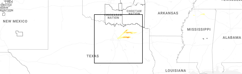
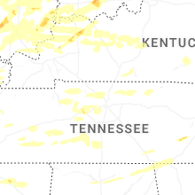
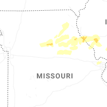
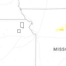
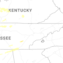
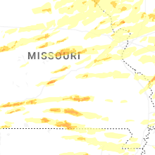
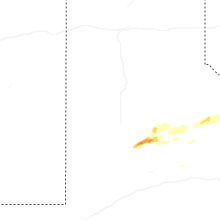
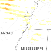
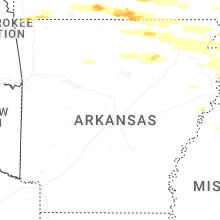
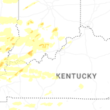
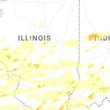
Hail Map for Monday, April 27, 2026
Number of Impacted Households on 4/27/2026
0
Impacted by 1" or Larger Hail
0
Impacted by 1.75" or Larger Hail
0
Impacted by 2.5" or Larger Hail
Square Miles of Populated Area Impacted on 4/27/2026
0
Impacted by 1" or Larger Hail
0
Impacted by 1.75" or Larger Hail
0
Impacted by 2.5" or Larger Hail
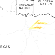


Cities Most Affected by Hail Storms of 4/27/2026
| Hail Size | Demographics of Zip Codes Affected | ||||||
|---|---|---|---|---|---|---|---|
| City | Count | Average | Largest | Pop Density | House Value | Income | Age |
| Bourbon, MO | 4 | 2.31 | 3.00 | 22 | $68k | $36.2k | 39.6 |
| Versailles, MO | 3 | 2.83 | 3.50 | 40 | $62k | $29.5k | 40.5 |
| Mount Vernon, MO | 3 | 2.25 | 2.50 | 65 | $74k | $32.9k | 41.1 |
| Willow Springs, MO | 3 | 2.00 | 2.50 | 24 | $52k | $22.5k | 40.8 |
| Elk Creek, MO | 2 | 2.88 | 3.00 | 9 | $41k | $21.7k | 50.4 |
| Commerce, TX | 2 | 2.63 | 3.50 | 109 | $60k | $25.5k | 28.1 |
| Houston, MO | 2 | 2.50 | 2.50 | 46 | $67k | $24.7k | 43.2 |
| Sullivan, MO | 1 | 4.00 | 4.00 | 53 | $78k | $36.0k | 38.8 |
| Mexico, MO | 2 | 1.88 | 2.00 | 67 | $67k | $33.0k | 38.9 |
| Rowlett, TX | 2 | 1.88 | 2.00 | 2856 | $116k | $71.3k | 39.2 |
| Alton, IL | 2 | 1.88 | 2.00 | 771 | $62k | $34.3k | 38.4 |
| Lebanon, MO | 2 | 1.75 | 1.75 | 73 | $75k | $30.1k | 38.8 |
| Rockwall, TX | 2 | 1.75 | 1.75 | 1196 | $154k | $65.8k | 38.0 |
| Wentworth, MO | 1 | 2.50 | 2.50 | 24 | $63k | $32.1k | 40.0 |
| Norwood, MO | 1 | 2.50 | 2.50 | 17 | $52k | $26.1k | 38.0 |
| Pomona, MO | 1 | 2.50 | 2.50 | 24 | $64k | $26.3k | 41.1 |
| Jerseyville, IL | 1 | 2.50 | 2.50 | 93 | $82k | $41.1k | 40.4 |
| Post, TX | 1 | 2.00 | 2.00 | 5 | $39k | $26.8k | 33.1 |
| Pacific, MO | 1 | 2.00 | 2.00 | 209 | $117k | $48.3k | 39.6 |
| Solo, MO | 1 | 2.00 | 2.00 | 18 | $23k | $48.5k | 40.7 |
| West Plains, MO | 1 | 2.00 | 2.00 | 54 | $73k | $27.3k | 39.0 |
| Ava, MO | 1 | 2.00 | 2.00 | 18 | $55k | $25.9k | 44.4 |
| Royse City, TX | 1 | 2.00 | 2.00 | 205 | $84k | $47.7k | 32.9 |
| Yukon, MO | 1 | 2.00 | 2.00 | 19 | $49k | $32.2k | 47.0 |
| Centerville, KS | 1 | 2.00 | 2.00 | 5 | $33k | $44.2k | 49.5 |
| Aurora, MO | 1 | 1.75 | 1.75 | 75 | $62k | $27.4k | 39.7 |
| Worden, IL | 1 | 1.75 | 1.75 | 74 | $80k | $45.8k | 40.6 |
| Leslie, MO | 1 | 1.75 | 1.75 | 34 | $88k | $41.1k | 42.3 |
| Moran, KS | 1 | 1.75 | 1.75 | 8 | $38k | $29.0k | 46.7 |
| Lonedell, MO | 1 | 1.75 | 1.75 | 43 | $73k | $46.8k | 42.1 |
| Quinlan, TX | 1 | 1.75 | 1.75 | 128 | $56k | $34.4k | 42.6 |
| Bethalto, IL | 1 | 1.75 | 1.75 | 508 | $82k | $45.2k | 40.4 |
| Eldon, MO | 1 | 1.75 | 1.75 | 81 | $69k | $30.6k | 40.4 |
| Richardson, TX | 1 | 1.75 | 1.75 | 4010 | $118k | $60.6k | 37.4 |
| Cave City, AR | 1 | 1.75 | 1.75 | 34 | $53k | $30.2k | 39.9 |
| Linden, IN | 1 | 1.75 | 1.75 | 29 | $85k | $41.5k | 36.9 |
| Holland, IN | 1 | 1.75 | 1.75 | 34 | $67k | $40.7k | 39.6 |
| Labadie, MO | 1 | 1.75 | 1.75 | 89 | $152k | $62.1k | 42.4 |
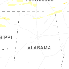
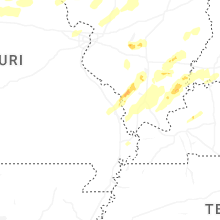
Hail and Wind Damage Spotted on 4/27/2026
Filter by Report Type:Hail ReportsWind Reports
States Impacted
Missouri, Illinois, Indiana, Kentucky, Kansas, Iowa, Texas, Nevada, Wisconsin, Mississippi, Arkansas, Tennessee, OhioMissouri
| Local Time | Report Details |
|---|---|
| 7:15 AM CDT | Trees down in roadway. large branches broken off trees. time estimated from rada in howard county MO, 29.4 miles NW of Columbia, MO |
| 7:24 AM CDT | Several power poles down in slate in saline county MO, 43.2 miles WNW of Columbia, MO |
| 7:25 AM CDT | Multiple large 12+ inch tree limbs dow in cass county MO, 33.7 miles SSE of Kansas City, MO |
| 7:28 AM CDT | Powerlines down on state route a. time estimated from rada in randolph county MO, 28.5 miles NNW of Columbia, MO |
| 7:29 AM CDT | Power pole tilted. time estimated from rada in randolph county MO, 29.1 miles NNW of Columbia, MO |
| 7:30 AM CDT | Flag pole knocked over. time estimated from rada in howard county MO, 21.6 miles NNW of Columbia, MO |
| 7:30 AM CDT | Large branch snapped. time estimated from rada in howard county MO, 22 miles NNW of Columbia, MO |
| 7:30 AM CDT | Large branch snapped. time estimated from rada in howard county MO, 22 miles NNW of Columbia, MO |
| 7:31 AM CDT | Large tree limbs broken. time estimated from rada in randolph county MO, 31.4 miles N of Columbia, MO |
| 7:31 AM CDT | Multiple limbs dow in randolph county MO, 29.4 miles N of Columbia, MO |
| 7:33 AM CDT | Large tree split on property and partially across the road. time estimated from rada in randolph county MO, 33.3 miles NNW of Columbia, MO |
| 7:35 AM CDT | Large tree branches snapped. time estimated from rada in randolph county MO, 27.1 miles N of Columbia, MO |
| 7:35 AM CDT | Storm damage reported in randolph county MO, 35.4 miles N of Columbia, MO |
| 7:51 AM CDT | Storm damage reported in monroe county MO, 43.1 miles NNE of Columbia, MO |
| 8:35 AM CDT | Quarter sized hail reported near Hannibal, MO, 55.5 miles SSE of Kahoka, MO |
| 12:25 PM CDT | Quarter sized hail reported near Saint Charles, MO, 22.1 miles WNW of Saint Louis, MO, report from mping: quarter (1.00 in.). |
| 1:34 PM CDT | Ping Pong Ball sized hail reported near Bridgeton, MO, 15.5 miles WNW of Saint Louis, MO, report from mping: ping pong ball (1.50 in.). |
| 1:35 PM CDT | Quarter sized hail reported near Chesterfield, MO, 20.8 miles W of Saint Louis, MO |
| 1:36 PM CDT | Quarter sized hail reported near Chesterfield, MO, 16.8 miles W of Saint Louis, MO |
| 1:38 PM CDT | Half Dollar sized hail reported near Chesterfield, MO, 20.6 miles W of Saint Louis, MO |
| 1:48 PM CDT | Quarter sized hail reported near Saint Louis, MO, 9.5 miles WNW of Saint Louis, MO, at midland and i-170. |
| 2:13 PM CDT | Quarter sized hail reported near Amoret, MO, 52.9 miles S of Kansas City, MO |
| 2:21 PM CDT | Quarter sized hail reported near Warrenton, MO, 58.6 miles E of Columbia, MO |
| 2:23 PM CDT | Quarter sized hail reported near Adrian, MO, 50.1 miles SSE of Kansas City, MO |
| 2:56 PM CDT | Quarter sized hail reported near Moscow Mills, MO, 44.8 miles WNW of Saint Louis, MO |
| 3:00 PM CDT | Power lines down on ethlyn r in lincoln county MO, 42.2 miles NW of Saint Louis, MO |
| 3:08 PM CDT | Quarter sized hail reported near Columbia, MO, 3.3 miles N of Columbia, MO, report from mping: quarter (1.00 in.). |
| 3:10 PM CDT | Quarter sized hail reported near Columbia, MO, 2.3 miles WNW of Columbia, MO, report from mping: quarter (1.00 in.). |
| 3:19 PM CDT | Quarter sized hail reported near Windsor, MO, 69.7 miles SE of Kansas City, MO, time estimated from radar. |
| 3:32 PM CDT | Quarter sized hail reported near Sedalia, MO, 50.1 miles WSW of Columbia, MO, time estimated from radar. |
| 3:36 PM CDT | Report from aso in pettis county MO, 48.1 miles WSW of Columbia, MO |
| 3:42 PM CDT | Hen Egg sized hail reported near Mexico, MO, 29.1 miles ENE of Columbia, MO |
| 3:54 PM CDT | Quarter sized hail reported near Syracuse, MO, 34.9 miles SW of Columbia, MO |
| 3:55 PM CDT | Ping Pong Ball sized hail reported near Mexico, MO, 28.7 miles ENE of Columbia, MO |
| 3:57 PM CDT | Quarter sized hail reported near Mexico, MO, 27.9 miles ENE of Columbia, MO, report from mping: quarter (1.00 in.). |
| 3:59 PM CDT | Quarter sized hail reported near Mexico, MO, 35.8 miles NE of Columbia, MO |
| 4:10 PM CDT | Quarter sized hail reported near Mexico, MO, 35.8 miles NE of Columbia, MO, second round of quarter-sized hail. |
| 4:10 PM CDT | Corrects previous tstm wnd dmg report from 1 e diamond. newton county diamond fire units out on trees down and up rooted on j highway east of diamond near deputy driv in newton county MO, 57.7 miles WSW of Springfield, MO |
| 4:10 PM CDT | Corrects previous tstm wnd dmg report from 1 e diamond. newton county diamond fire units out on trees down and up rooted on j highway east of diamond near deputy driv in newton county MO, 57.7 miles WSW of Springfield, MO |
| 4:10 PM CDT | Golf Ball sized hail reported near Mexico, MO, 29 miles ENE of Columbia, MO, picture received of hail with a quarter for reference. time estimated. |
| 4:12 PM CDT | Powerlines dow in jasper county MO, 49.3 miles W of Springfield, MO |
| 4:15 PM CDT | Quarter sized hail reported near Sarcoxie, MO, 46.7 miles WSW of Springfield, MO, heavy rain... pea size hail... sporadic quarter size hail... a few strong gusts of wind. |
| 4:22 PM CDT | Quarter sized hail reported near Sarcoxie, MO, 40.6 miles WSW of Springfield, MO, nickle to quarter sized hail reported at i44 34 mm. |
| 4:24 PM CDT | Tennis Ball sized hail reported near Wentworth, MO, 40.3 miles WSW of Springfield, MO, from spotter from joplin fire that lives on highway 97... three miles south of i-44. had approximately 2-3” hail just now at his house. |
| 4:28 PM CDT | Hen Egg sized hail reported near Versailles, MO, 42.5 miles SW of Columbia, MO, about 3 miles north versailles. |
| 4:28 PM CDT | Tea Cup sized hail reported near Versailles, MO, 42.5 miles SW of Columbia, MO, corrects previous hail report from 3 n versailles. corrects previous hail report from 3 n versailles. about 3 miles north versailles. |
| 4:28 PM CDT | Tea Cup sized hail reported near Versailles, MO, 42.5 miles SW of Columbia, MO, corrects previous hail report from 3 n versailles. about 3 miles north versailles. hail ranged from versailles 1 inch to 3.5 inch. |
| 4:30 PM CDT | Golf Ball sized hail reported near Mount Vernon, MO, 29.8 miles WSW of Springfield, MO, it was bigger than a quarter and smaller than a lime. |
| 4:34 PM CDT | Tree branch on the road... almost all of road is blocke in lawrence county MO, 30.3 miles WSW of Springfield, MO |
| 4:35 PM CDT | Two reports of trees down around hill top roa in mcdonald county MO, 78.5 miles N of Fort Smith, AR |
| 4:36 PM CDT | Tennis Ball sized hail reported near Mount Vernon, MO, 30.1 miles WSW of Springfield, MO, numerous reports of tennis ball size hail. |
| 4:40 PM CDT | Quarter sized hail reported near Mexico, MO, 35.8 miles NE of Columbia, MO, third round of quarter-sized hail. |
| 4:42 PM CDT | Golf Ball sized hail reported near Aurora, MO, 26.8 miles WSW of Springfield, MO, report from mping golf ball size hail. |
| 4:45 PM CDT | Tennis Ball sized hail reported near Mount Vernon, MO, 30.1 miles WSW of Springfield, MO |
| 4:54 PM CDT | Republic registered 67mph gust on south and southwest portion of city. measured hail just over 1inch on west elm. several trees down south of elm street. two on house in greene county MO, 12.1 miles WSW of Springfield, MO |
| 4:55 PM CDT | Large tree dow in greene county MO, 12.1 miles WSW of Springfield, MO |
| 5:00 PM CDT | 3 reports of trees into homes... 60 -70 mph winds and pea sized hail all in monet in barry county MO, 40.5 miles WSW of Springfield, MO |
| 5:02 PM CDT | Ping Pong Ball sized hail reported near Republic, MO, 10.8 miles WSW of Springfield, MO, report from mping ping pong ball size hail of 1.50 in. |
| 5:04 PM CDT | Quarter sized hail reported near Republic, MO, 11.1 miles SW of Springfield, MO, report from mping quarter size hail of 1.00 in. |
| 5:05 PM CDT | Powerline down at westview and kansa in greene county MO, 4.2 miles SSW of Springfield, MO |
| 5:06 PM CDT | Tree and power line down over the roadwa in lawrence county MO, 42.6 miles WSW of Springfield, MO |
| 5:12 PM CDT | Golf Ball sized hail reported near Eldon, MO, 42.3 miles SSW of Columbia, MO, quarter and golf ball size hail. |
| 5:12 PM CDT | Half Dollar sized hail reported near Springfield, MO, 5.8 miles SE of Springfield, MO, report from mping half dollar size. |
| 5:14 PM CDT | Quarter sized hail reported near Springfield, MO, 6.1 miles SSE of Springfield, MO, report from mping - quarter (1.00 in.). |
| 5:15 PM CDT | Quarter sized hail reported near Springfield, MO, 3 miles SE of Springfield, MO, report from mping quarter hail of 1.00 in. |
| 5:18 PM CDT | Quarter sized hail reported near Marionville, MO, 24.9 miles SW of Springfield, MO, from spotter estimated 1.00 inch hail. |
| 5:18 PM CDT | Half Dollar sized hail reported near Springfield, MO, 3.6 miles ESE of Springfield, MO, quarter to half dollar sized hail 3000 block e. catalpa sgf. |
| 5:18 PM CDT | Half Dollar sized hail reported near Pineville, MO, 68 miles SW of Springfield, MO |
| 5:18 PM CDT | Amateur radio report 1 foot diameter pine tree down at stanford and ranc in greene county MO, 4.9 miles ESE of Springfield, MO |
| 5:30 PM CDT | Quarter sized hail reported near Winfield, MO, 39.3 miles NW of Saint Louis, MO |
| 5:30 PM CDT | Golf Ball sized hail reported near Lebanon, MO, 46.6 miles NE of Springfield, MO, golf ball sized hail reported by fire at 17:30 at the lebanon airport. no picture. |
| 5:30 PM CDT | Spotter reporting a 3 foot diameter tree down in rogersville at white oak and bobcat roa in webster county MO, 15.4 miles ESE of Springfield, MO |
| 5:31 PM CDT | Quarter sized hail reported near Rogersville, MO, 14.4 miles ESE of Springfield, MO, report from mping quarter. 1.00 inch. |
| 5:32 PM CDT | Quarter sized hail reported near Lebanon, MO, 45.3 miles NE of Springfield, MO, report from mping quarter size 1.00 inch. |
| 5:35 PM CDT | Ping Pong Ball sized hail reported near Silex, MO, 57.5 miles NW of Saint Louis, MO, time estimated. |
| 5:44 PM CDT | Golf Ball sized hail reported near Lebanon, MO, 47.9 miles NE of Springfield, MO, report from mping golf ball. |
| 5:50 PM CDT | Tree down near highway 32 and highway in laclede county MO, 50.9 miles NE of Springfield, MO |
| 5:55 PM CDT | Quarter sized hail reported near Bland, MO, 51.3 miles N of Salem, MO, quarter sized hail in copper hill. location and time estimated. |
| 6:02 PM CDT | Quarter sized hail reported near Bland, MO, 49 miles SE of Columbia, MO, ham operator reported quarter-sized hail at cooper hill. |
| 6:12 PM CDT | Trooper out with a downed tree on highway 28 near columbia rd in pulaski count in pulaski county MO, 38.5 miles NW of Salem, MO |
| 6:15 PM CDT | Ping Pong Ball sized hail reported near Bourbon, MO, 38.7 miles NNE of Salem, MO |
| 6:15 PM CDT | Quarter sized hail reported near Sullivan, MO, 44.5 miles NNE of Salem, MO, hail varied from pea-size to quarter-size. |
| 6:15 PM CDT | Golf Ball sized hail reported near Bourbon, MO, 38.7 miles NNE of Salem, MO |
| 6:15 PM CDT | Half Dollar sized hail reported near Sullivan, MO, 44.5 miles NNE of Salem, MO, pictures received. time and size estimated. |
| 6:15 PM CDT | Tree down at champion city rd and red oak rd. time estimate in franklin county MO, 53.9 miles NNE of Salem, MO |
| 6:16 PM CDT | Tea Cup sized hail reported near Bourbon, MO, 38.7 miles NNE of Salem, MO |
| 6:20 PM CDT | Quarter sized hail reported near Warrenton, MO, 52.5 miles WNW of Saint Louis, MO, time estimated. |
| 6:20 PM CDT | Tennis Ball sized hail reported near Bourbon, MO, 38.7 miles NNE of Salem, MO, report from mping: tennis ball (2.50 in.). |
| 6:23 PM CDT | Hen Egg sized hail reported near Bourbon, MO, 38.7 miles NNE of Salem, MO, 2+ inch hail near bourbon elementary school. |
| 6:23 PM CDT | Quarter sized hail reported near Warrenton, MO, 52.5 miles WNW of Saint Louis, MO |
| 6:24 PM CDT | Quarter sized hail reported near Bourbon, MO, 38.7 miles NNE of Salem, MO, report from mping: quarter (1.00 in.). |
| 6:25 PM CDT | Golf Ball sized hail reported near Leslie, MO, 58.2 miles NNE of Salem, MO |
| 6:26 PM CDT | Half Dollar sized hail reported near Gerald, MO, 51.2 miles NNE of Salem, MO |
| 6:30 PM CDT | Quarter sized hail reported near Saint Peters, MO, 27.8 miles WNW of Saint Louis, MO, near mexico road and salt lick. |
| 6:35 PM CDT | Grapefruit sized hail reported near Sullivan, MO, 48.8 miles NE of Salem, MO, numerous hailstones measuring 2-inches by 4-inches. |
| 6:35 PM CDT | Quarter sized hail reported near O Fallon, MO, 31.3 miles WNW of Saint Louis, MO |
| 6:35 PM CDT | Half Dollar sized hail reported near O Fallon, MO, 29.5 miles WNW of Saint Louis, MO |
| 6:36 PM CDT | Half Dollar sized hail reported near O Fallon, MO, 28.4 miles WNW of Saint Louis, MO, report from mping: half dollar (1.25 in.). |
| 6:36 PM CDT | Larger size branches down and tree uproote in douglas county MO, 39.2 miles ESE of Springfield, MO |
| 6:37 PM CDT | Quarter sized hail reported near Saint Peters, MO, 27.6 miles WNW of Saint Louis, MO |
| 6:39 PM CDT | Half Dollar sized hail reported near O Fallon, MO, 29.8 miles WNW of Saint Louis, MO |
| 6:40 PM CDT | Large tree blocking the road at webber creek rd and camp mo val rd. time estimate in franklin county MO, 49.8 miles WSW of Saint Louis, MO |
| 6:41 PM CDT | Quarter sized hail reported near Ava, MO, 39.7 miles ESE of Springfield, MO, spotter reporting 1 inch hail in ava near hwy 14 and ff. |
| 6:42 PM CDT | Tennis Ball sized hail reported near Norwood, MO, 52.1 miles ESE of Springfield, MO |
| 6:44 PM CDT | Quarter sized hail reported near Pacific, MO, 32.3 miles WSW of Saint Louis, MO, report from mping: quarter (1.00 in.). |
| 6:45 PM CDT | Tennis Ball sized hail reported near Houston, MO, 34.2 miles SW of Salem, MO |
| 6:45 PM CDT | Tree completely blocking the roadwa in phelps county MO, 17.6 miles N of Salem, MO |
| 6:45 PM CDT | 3 trees down at highway 100 and thornton r in franklin county MO, 31.9 miles WSW of Saint Louis, MO |
| 6:45 PM CDT | Large tree down on bassett r in franklin county MO, 29.6 miles W of Saint Louis, MO |
| 6:45 PM CDT | Golf Ball sized hail reported near Lonedell, MO, 47.3 miles SW of Saint Louis, MO, time estimated. |
| 6:45 PM CDT | A 24-inch tree was uprooted and smashed into a pickup truc in franklin county MO, 47.9 miles WSW of Saint Louis, MO |
| 6:45 PM CDT | Hen Egg sized hail reported near Ava, MO, 47.3 miles ESE of Springfield, MO |
| 6:45 PM CDT | Tree completely blocking the roadwa in phelps county MO, 17.7 miles N of Salem, MO |
| 6:46 PM CDT | Golf Ball sized hail reported near Labadie, MO, 33 miles WSW of Saint Louis, MO |
| 6:48 PM CDT | Ping Pong Ball sized hail reported near Norwood, MO, 50.5 miles ESE of Springfield, MO |
| 6:48 PM CDT | Estimated wind coupled with golf ball-sized hai in franklin county MO, 34.4 miles WSW of Saint Louis, MO |
| 6:48 PM CDT | Half Dollar sized hail reported near Pacific, MO, 33.4 miles WSW of Saint Louis, MO, report from mping: half dollar (1.25 in.). |
| 6:50 PM CDT | Large tree limb down in av in douglas county MO, 39.2 miles ESE of Springfield, MO |
| 6:51 PM CDT | Tea Cup sized hail reported near Elk Creek, MO, 40 miles SW of Salem, MO |
| 6:51 PM CDT | Ping Pong Ball sized hail reported near Houston, MO, 36.7 miles SW of Salem, MO |
| 6:54 PM CDT | Hen Egg sized hail reported near Solo, MO, 36.1 miles SW of Salem, MO |
| 6:54 PM CDT | Hen Egg sized hail reported near Pacific, MO, 30.6 miles WSW of Saint Louis, MO, report from mping: hen egg (2.00 in.). |
| 6:56 PM CDT | Quarter sized hail reported near Elk Creek, MO, 40 miles SW of Salem, MO, report from mping quarter 1.00 in. |
| 6:58 PM CDT | Quarter sized hail reported near Dittmer, MO, 33.2 miles SW of Saint Louis, MO, quarter size hail. |
| 6:58 PM CDT | Quarter sized hail reported near Ballwin, MO, 22.8 miles W of Saint Louis, MO, report from mping: quarter (1.00 in.). |
| 7:00 PM CDT | Large tree branch split off of trun in taney county MO, 37 miles SSE of Springfield, MO |
| 7:00 PM CDT | Tennis Ball sized hail reported near Houston, MO, 34.2 miles SW of Salem, MO, corrects previous hail report from 3 e solo time should be 7pm. |
| 7:00 PM CDT | Hen Egg sized hail reported near Yukon, MO, 30.6 miles SW of Salem, MO |
| 7:10 PM CDT | 4 buildings collapsed in florissan in st. louis county MO, 13.6 miles NNW of Saint Louis, MO |
| 7:11 PM CDT | Power outage as the wind gust moved i in st. louis county MO, 12 miles NW of Saint Louis, MO |
| 7:12 PM CDT | Baseball sized hail reported near Elk Creek, MO, 34.5 miles SSW of Salem, MO |
| 7:17 PM CDT | On i-55 near arnol in jefferson county MO, 17.3 miles SW of Saint Louis, MO |
| 7:18 PM CDT | Storm damage reported in jefferson county MO, 16.5 miles SW of Saint Louis, MO |
| 7:18 PM CDT | Golf Ball sized hail reported near Willow Springs, MO, 55.2 miles SSW of Salem, MO, report from mping golf ball 1.75 inch. |
| 7:20 PM CDT | Power line down on mccauslan in st. louis city county MO, 6 miles W of Saint Louis, MO |
| 7:24 PM CDT | Golf Ball sized hail reported near Willow Springs, MO, 50.6 miles SSW of Salem, MO |
| 7:24 PM CDT | Ping Pong Ball sized hail reported near Summersville, MO, 32.2 miles SSW of Salem, MO |
| 7:28 PM CDT | Quarter sized hail reported near Pomona, MO, 56.8 miles SSW of Salem, MO |
| 7:38 PM CDT | Tennis Ball sized hail reported near Willow Springs, MO, 50.1 miles SSW of Salem, MO |
| 7:48 PM CDT | Tennis Ball sized hail reported near Pomona, MO, 57.7 miles SSW of Salem, MO |
| 7:51 PM CDT | Quarter sized hail reported near West Plains, MO, 57.4 miles SSW of Salem, MO |
| 7:55 PM CDT | Quarter sized hail reported near Tecumseh, MO, 72.6 miles SE of Springfield, MO, also reported at 160 and j hwy. |
| 8:00 PM CDT | Half Dollar sized hail reported near Moody, MO, 80.3 miles SSW of Salem, MO |
| 8:15 PM CDT | Hen Egg sized hail reported near West Plains, MO, 64.9 miles SSW of Salem, MO |
| 8:17 PM CDT | Quarter sized hail reported near Moody, MO, 80.3 miles SSW of Salem, MO |
| 8:35 PM CDT | Storm damage reported in st. francois county MO, 58.7 miles NW of Cape Girardeau, MO |
| 8:40 PM CDT | Half Dollar sized hail reported near Farmington, MO, 59.1 miles NW of Cape Girardeau, MO, report from mping: half dollar (1.25 in.). |
| 9:11 PM CDT | Very large live tree snapped... numerous large branches down off multiple trees. time estimated from rada in ripley county MO, 65.6 miles SSE of Salem, MO |
| 9:42 PM CDT | 50 to 60 mph wind gusts in stringtown or about 10 miles west of poplar bluf in butler county MO, 68.8 miles WSW of Cape Girardeau, MO |
Illinois
| Local Time | Report Details |
|---|---|
| 7:24 AM CDT | Half Dollar sized hail reported near Goreville, IL, 36.2 miles ENE of Cape Girardeau, MO |
| 8:41 AM CDT | Quarter sized hail reported near Murphysboro, IL, 34.1 miles NNE of Cape Girardeau, MO |
| 8:50 AM CDT | Half Dollar sized hail reported near Springfield, IL, 63.8 miles S of Peoria, IL, delayed report from morning storms. picture of quarter to half dollar size hail. |
| 8:55 AM CDT | Quarter sized hail reported near Springfield, IL, 64.4 miles S of Peoria, IL |
| 8:56 AM CDT | Quarter sized hail reported near Springfield, IL, 66.4 miles S of Peoria, IL, report from mping: quarter (1.00 in.). |
| 8:56 AM CDT | Quarter sized hail reported near Springfield, IL, 62.3 miles S of Peoria, IL |
| 8:57 AM CDT | Ping Pong Ball sized hail reported near Springfield, IL, 61.6 miles S of Peoria, IL |
| 8:58 AM CDT | Half Dollar sized hail reported near Springfield, IL, 62.3 miles S of Peoria, IL, report from mping: half dollar (1.25 in.). |
| 8:59 AM CDT | Quarter sized hail reported near Springfield, IL, 64.5 miles S of Peoria, IL, report from mping: quarter (1.00 in.). |
| 8:59 AM CDT | Ping Pong Ball sized hail reported near Springfield, IL, 60.9 miles S of Peoria, IL |
| 8:59 AM CDT | Quarter sized hail reported near Christopher, IL, 54 miles NNE of Cape Girardeau, MO, southwest side of christopher. |
| 9:01 AM CDT | Quarter sized hail reported near Springfield, IL, 61.6 miles S of Peoria, IL, report from mping: quarter (1.00 in.). |
| 9:25 AM CDT | Ema reports tree and powerlines downed by thunderstorm wind in morgan county IL, 77.9 miles SW of Peoria, IL |
| 9:31 AM CDT | Report of several tree branches broken off in the city of macom in mcdonough county IL, 54.9 miles E of Kahoka, MO |
| 9:36 AM CDT | Storm damage reported in fulton county IL, 44 miles WSW of Peoria, IL |
| 9:55 AM CDT | Quarter sized hail reported near Macedonia, IL, 62.8 miles W of Evansville, IN, report from mping of quarter (1.00 in.). |
| 10:38 AM CDT | Semi blown over onto the media in montgomery county IL, 64.8 miles NNE of Saint Louis, MO |
| 10:44 AM CDT | Ping Pong Ball sized hail reported near Omaha, IL, 38 miles WSW of Evansville, IN |
| 10:48 AM CDT | Tree downed across roadway... causing a semi rollove in christian county IL, 52.6 miles W of Mattoon, IL |
| 11:30 AM CDT | Quarter sized hail reported near Olney, IL, 54.7 miles SSE of Mattoon, IL |
| 11:31 AM CDT | Quarter sized hail reported near Olney, IL, 54.4 miles SSE of Mattoon, IL, report from mping: quarter (1.00 in.). |
| 11:55 AM CDT | Half Dollar sized hail reported near Eureka, IL, 16.8 miles E of Peoria, IL, report from mping: half dollar (1.25 in.). |
| 12:41 PM CDT | Tree blown down into a mobile home. no injuries reporte in effingham county IL, 35.3 miles SW of Mattoon, IL |
| 1:16 PM CDT | Wind gust from an automated weather statio in crawford county IL, 41.6 miles SE of Mattoon, IL |
| 1:52 PM CDT | Shed damage in madison county IL, 23.7 miles ENE of Saint Louis, MO |
| 2:21 PM CDT | Quarter sized hail reported near Glen Carbon, IL, 15.4 miles NE of Saint Louis, MO |
| 3:19 PM CDT | Quarter sized hail reported near Claremont, IL, 53.7 miles NNW of Evansville, IN |
| 3:30 PM CDT | Quarter sized hail reported near Bridgeport, IL, 51.7 miles NNW of Evansville, IN |
| 3:32 PM CDT | Quarter sized hail reported near Bridgeport, IL, 51.7 miles NNW of Evansville, IN |
| 3:38 PM CDT | Half Dollar sized hail reported near Bridgeport, IL, 51.7 miles NNW of Evansville, IN, report from mping: half dollar (1.25 in.). |
| 5:12 PM CDT | Ping Pong Ball sized hail reported near Congerville, IL, 20 miles ESE of Peoria, IL, report from mping: ping pong ball (1.50 in.). |
| 5:36 PM CDT | Half Dollar sized hail reported near Albion, IL, 37.3 miles NW of Evansville, IN |
| 5:40 PM CDT | Power lines dow in morgan county IL, 69.4 miles SSW of Peoria, IL |
| 5:48 PM CDT | Quarter sized hail reported near Pleasant Plains, IL, 59.4 miles SSW of Peoria, IL |
| 5:52 PM CDT | Quarter sized hail reported near Tallula, IL, 54.5 miles SSW of Peoria, IL, north end of tallula. |
| 5:55 PM CDT | Ping Pong Ball sized hail reported near Jerseyville, IL, 34.7 miles NNW of Saint Louis, MO |
| 5:58 PM CDT | Quarter sized hail reported near Jerseyville, IL, 35.9 miles N of Saint Louis, MO, report from mping: quarter (1.00 in.). |
| 6:00 PM CDT | Tennis Ball sized hail reported near Jerseyville, IL, 34.7 miles NNW of Saint Louis, MO |
| 6:10 PM CDT | Storm damage reported in champaign county IL, 38.9 miles N of Mattoon, IL |
| 6:10 PM CDT | Storm damage reported in champaign county IL, 48.7 miles NNE of Mattoon, IL |
| 6:14 PM CDT | Tree and power lines dow in logan county IL, 39.8 miles SSE of Peoria, IL |
| 6:15 PM CDT | Storm damage reported in logan county IL, 39.6 miles SSE of Peoria, IL |
| 6:16 PM CDT | Large tree down & out building tin scattered around propert in logan county IL, 48.6 miles SSE of Peoria, IL |
| 6:17 PM CDT | Large tree uproote in logan county IL, 49.1 miles SSE of Peoria, IL |
| 6:17 PM CDT | Picture of tree snappe in logan county IL, 49 miles SSE of Peoria, IL |
| 6:29 PM CDT | Large tree down blocking both lane in vermilion county IL, 59.3 miles NE of Mattoon, IL |
| 6:30 PM CDT | Quarter sized hail reported near Mount Carmel, IL, 35.9 miles NNW of Evansville, IN |
| 6:36 PM CDT | 12 inch live tree with top blown of in macon county IL, 38.5 miles NW of Mattoon, IL |
| 6:38 PM CDT | Storm damage reported in macon county IL, 47.8 miles NW of Mattoon, IL |
| 6:39 PM CDT | Estimated 70-80 mph wind in logan county IL, 53.7 miles NW of Mattoon, IL |
| 6:42 PM CDT | Tree on a hous in de witt county IL, 51 miles NNW of Mattoon, IL |
| 6:43 PM CDT | Storm damage reported in macon county IL, 50.3 miles NW of Mattoon, IL |
| 6:44 PM CDT | Corrects previous flash flood report from 2 wnw de land. deland-weldon school sustained roof damag in piatt county IL, 47.8 miles NNW of Mattoon, IL |
| 6:45 PM CDT | Tree down across south bound lane of state 11 in vermilion county IL, 70.2 miles NE of Mattoon, IL |
| 6:48 PM CDT | Older tree dow in de witt county IL, 48.3 miles NNW of Mattoon, IL |
| 6:48 PM CDT | Older tree dow in de witt county IL, 48.3 miles NNW of Mattoon, IL |
| 6:50 PM CDT | Golf Ball sized hail reported near Alton, IL, 19 miles N of Saint Louis, MO |
| 6:52 PM CDT | Quarter sized hail reported near Alton, IL, 20.9 miles N of Saint Louis, MO, hail from the sizes of dimes to quarters. |
| 6:54 PM CDT | Tree fell on a building in spitler woods state par in macon county IL, 33 miles NW of Mattoon, IL |
| 6:55 PM CDT | Ping Pong Ball sized hail reported near Godfrey, IL, 20.9 miles N of Saint Louis, MO, report from mping: ping pong ball (1.50 in.). |
| 6:56 PM CDT | Hen Egg sized hail reported near Alton, IL, 20.4 miles NNE of Saint Louis, MO |
| 6:59 PM CDT | Quarter sized hail reported near Alton, IL, 19.8 miles N of Saint Louis, MO, report from mping: quarter (1.00 in.). |
| 6:59 PM CDT | Pictures of damage to several machine sheds and buildings near a grain elevator. possible tornad in piatt county IL, 47.2 miles NNW of Mattoon, IL |
| 7:00 PM CDT | Half Dollar sized hail reported near East Alton, IL, 19.2 miles NNE of Saint Louis, MO |
| 7:03 PM CDT | Half Dollar sized hail reported near Bethalto, IL, 20.4 miles NNE of Saint Louis, MO |
| 7:03 PM CDT | Storm damage reported in champaign county IL, 43.5 miles N of Mattoon, IL |
| 7:05 PM CDT | Tree on a hous in champaign county IL, 49 miles N of Mattoon, IL |
| 7:06 PM CDT | Power lines down with road closur in champaign county IL, 49.7 miles N of Mattoon, IL |
| 7:06 PM CDT | Numerous 4-8 inch diameter tree branches down. fences blown down to in champaign county IL, 48.9 miles N of Mattoon, IL |
| 7:07 PM CDT | Golf Ball sized hail reported near Bethalto, IL, 20.9 miles NNE of Saint Louis, MO, report from mping: golf ball (1.75 in.). |
| 7:07 PM CDT | Storm damage reported in champaign county IL, 48.9 miles N of Mattoon, IL |
| 7:08 PM CDT | Quarter sized hail reported near Bunker Hill, IL, 31.5 miles NNE of Saint Louis, MO, report from mping: quarter (1.00 in.). |
| 7:09 PM CDT | Quarter sized hail reported near Bunker Hill, IL, 30.2 miles NNE of Saint Louis, MO, report from mping: quarter (1.00 in.). |
| 7:10 PM CDT | Half Dollar sized hail reported near Bethalto, IL, 20.4 miles NNE of Saint Louis, MO |
| 7:10 PM CDT | Quarter sized hail reported near Dorsey, IL, 26 miles NNE of Saint Louis, MO |
| 7:11 PM CDT | Quarter sized hail reported near Moro, IL, 23.7 miles NE of Saint Louis, MO, report from mping: quarter (1.00 in.). |
| 7:13 PM CDT | Golf Ball sized hail reported near Worden, IL, 25.4 miles NE of Saint Louis, MO |
| 7:15 PM CDT | Ping Pong Ball sized hail reported near Litchfield, IL, 47.4 miles NE of Saint Louis, MO |
| 7:15 PM CDT | Half Dollar sized hail reported near Moro, IL, 23.7 miles NE of Saint Louis, MO, report from mping: half dollar (1.25 in.). |
| 7:15 PM CDT | An 8-10 inch diameter tree limb was downed on east patton st between washington and college streets in paxton. time estimated using rada in ford county IL, 69.2 miles NNE of Mattoon, IL |
| 7:15 PM CDT | Numerous large branches down 4-6 inches in diameter. wooden fences blown ove in champaign county IL, 49.6 miles N of Mattoon, IL |
| 7:16 PM CDT | Tree limbs dow in champaign county IL, 53.3 miles N of Mattoon, IL |
| 7:16 PM CDT | Trees and power lines down near centennial par in champaign county IL, 43 miles N of Mattoon, IL |
| 7:18 PM CDT | Quarter sized hail reported near Staunton, IL, 36.5 miles NE of Saint Louis, MO, report from mping: quarter (1.00 in.). |
| 7:20 PM CDT | Quarter sized hail reported near Staunton, IL, 34.8 miles NE of Saint Louis, MO, report from mping: quarter (1.00 in.). |
| 7:20 PM CDT | Quarter sized hail reported near Staunton, IL, 34.4 miles NE of Saint Louis, MO |
| 7:25 PM CDT | Quarter sized hail reported near Edwardsville, IL, 20.1 miles NE of Saint Louis, MO |
| 7:26 PM CDT | A tree was reported down onto a truck in buckley. time estimated by rada in iroquois county IL, 79.2 miles NNE of Mattoon, IL |
| 7:27 PM CDT | Picture of large tree with snapped branche in logan county IL, 53.7 miles NW of Mattoon, IL |
| 7:28 PM CDT | Trees down on sidney/st joseph rd... near home lake r in champaign county IL, 41.6 miles NNE of Mattoon, IL |
| 7:30 PM CDT | A large tree was downed and blocking a driveway along il-9 southeast of elliot in ford county IL, 67.8 miles N of Mattoon, IL |
| 7:30 PM CDT | Picture of tree down in tow in champaign county IL, 46.9 miles NNE of Mattoon, IL |
| 7:30 PM CDT | Storm damage reported in madison county IL, 26.5 miles NE of Saint Louis, MO |
| 7:32 PM CDT | Estimated over 60 mph wind in champaign county IL, 48.7 miles NNE of Mattoon, IL |
| 7:33 PM CDT | Quarter sized hail reported near Columbia, IL, 13.7 miles S of Saint Louis, MO, report from mping: quarter (1.00 in.). |
| 7:34 PM CDT | Measured at an ambient pw in iroquois county IL, 80.9 miles S of Chicago, IL |
| 7:35 PM CDT | *** 3 inj *** tree onto a house with potential injurie in st. clair county IL, 14.4 miles SE of Saint Louis, MO |
| 7:35 PM CDT | Picture of tree down on a hous in champaign county IL, 48.7 miles NNE of Mattoon, IL |
| 7:40 PM CDT | Tree down on hous in vermilion county IL, 37.6 miles NE of Mattoon, IL |
| 7:55 PM CDT | Picture of metal in a fiel in effingham county IL, 30.8 miles SW of Mattoon, IL |
| 8:30 PM CDT | Power lines down all over town. time estimate in marion county IL, 58.3 miles E of Saint Louis, MO |
| 9:00 PM CDT | Tree on apartments. injuries unknow in clay county IL, 49.5 miles S of Mattoon, IL |
| 9:00 PM CDT | Corrects previous tstm wnd dmg report from xenia. limb over the roa in clay county IL, 59.8 miles SSW of Mattoon, IL |
| 9:00 PM CDT | Corrects previous tstm wnd dmg report from xenia. limb over the roa in clay county IL, 59.8 miles SSW of Mattoon, IL |
| 9:20 PM CDT | Quarter sized hail reported near Mount Vernon, IL, 75 miles ESE of Saint Louis, MO |
| 9:48 PM CDT | Ping Pong Ball sized hail reported near Gorham, IL, 29 miles N of Cape Girardeau, MO |
| 9:50 PM CDT | Quarter sized hail reported near Carbondale, IL, 34.8 miles NNE of Cape Girardeau, MO |
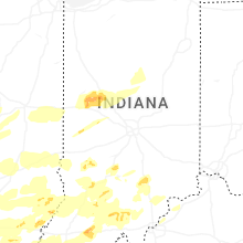
Indiana
| Local Time | Report Details |
|---|---|
| 12:23 PM CDT | Quarter sized hail reported near Princeton, IN, 25.8 miles N of Evansville, IN |
| 12:23 PM CDT | Quarter sized hail reported near Chandler, IN, 7.7 miles NE of Evansville, IN |
| 12:32 PM CDT | Quarter sized hail reported near Oakland City, IN, 27.6 miles NNE of Evansville, IN |
| 12:37 PM CDT | Quarter sized hail reported near Newburgh, IN, 9.5 miles E of Evansville, IN |
| 1:05 PM CDT | Half Dollar sized hail reported near Dale, IN, 29.5 miles ENE of Evansville, IN |
| 2:10 PM EDT | Quarter sized hail reported near Washington, IN, 51.8 miles NNE of Evansville, IN |
| 2:15 PM EDT | Golf Ball sized hail reported near Holland, IN, 34.2 miles ENE of Evansville, IN |
| 2:28 PM EDT | Quarter sized hail reported near Elnora, IN, 67.6 miles NNE of Evansville, IN |
| 2:44 PM EDT | Several large tree limbs downed in town. time estimated from rada in sullivan county IN, 56.3 miles ESE of Mattoon, IL |
| 2:55 PM EDT | Quarter sized hail reported near Shoals, IN, 71.9 miles NE of Evansville, IN, via social media. time estimated from radar. |
| 3:01 PM EDT | Quarter sized hail reported near Williams, IN, 69.5 miles SSW of Indianapolis, IN |
| 3:16 PM EDT | Quarter sized hail reported near Coal City, IN, 54 miles SW of Indianapolis, IN, time estimated from radar. |
| 3:31 PM EDT | Power lines down. time estimated based on rada in greene county IN, 66.1 miles SW of Indianapolis, IN |
| 3:43 PM EDT | At kbm in monroe county IN, 49.4 miles SSW of Indianapolis, IN |
| 3:44 PM EDT | Quarter sized hail reported near Bloomington, IN, 50.8 miles SSW of Indianapolis, IN, report from mping: quarter (1.00 in.). |
| 3:47 PM EDT | Quarter sized hail reported near Bloomington, IN, 45.9 miles SSW of Indianapolis, IN, report from mping: quarter (1.00 in.). |
| 3:48 PM EDT | Quarter sized hail reported near Bloomington, IN, 46.4 miles SSW of Indianapolis, IN, report from mping: quarter (1.00 in.). |
| 3:54 PM EDT | Half Dollar sized hail reported near Bloomington, IN, 49.7 miles SSW of Indianapolis, IN, report from mping: half dollar (1.25 in.). |
| 3:57 PM EDT | Pea sized hail als in daviess county IN, 72 miles NNE of Evansville, IN |
| 4:02 PM EDT | Quarter sized hail reported near Bloomington, IN, 46.7 miles SSW of Indianapolis, IN, report from mping: quarter (1.00 in.). |
| 4:28 PM EDT | Quarter sized hail reported near Loogootee, IN, 65.5 miles NNE of Evansville, IN, time estimated from radar. |
| 4:43 PM EDT | Tree over roadwa in knox county IN, 52.1 miles N of Evansville, IN |
| 4:52 PM EDT | 30 power poles down. time estimated from rada in jackson county IN, 55.9 miles S of Indianapolis, IN |
| 5:00 PM EDT | Damage to multiple power poles and house roofs. time based on rada in jackson county IN, 55.9 miles S of Indianapolis, IN |
| 5:04 PM EDT | Storm damage reported in jackson county IN, 56.2 miles SSE of Indianapolis, IN |
| 5:05 PM EDT | Multiple trees down just south of french lick along sr 14 in orange county IN, 61.7 miles NW of Louisville, KY |
| 5:54 PM EDT | Several trees and power lines down along eagle hollow roa in jefferson county IN, 50.8 miles WSW of Cincinnati, OH |
| 5:56 PM EDT | Corrects previous tstm wnd dmg report from 1 s thales. tree down blocking traffic and also down across potential power lines on n hickory r in dubois county IN, 55 miles NE of Evansville, IN |
| 6:06 PM EDT | Tree down on e 125 in ripley county IN, 37.6 miles W of Cincinnati, OH |
| 6:23 PM EDT | Corrects previous tstm wnd dmg report from 1 s birdseye. tree down blocking both lanes on sr 145 s of conservation club rd. time estimated by rada in dubois county IN, 52.6 miles ENE of Evansville, IN |
| 6:31 PM EDT | Multiple trees down in the greenfield township near west county road 560 sout in orange county IN, 53.6 miles NW of Louisville, KY |
| 6:56 PM EDT | Corrects previous tstm wnd dmg report from greenville. tree reported down on power lines at corner of pekin rd and clark st... time estimated by rada in floyd county IN, 30.3 miles NNW of Louisville, KY |
| 6:56 PM EDT | Corrects previous tstm wnd dmg report from 2 nnw greenville. tree was reported down on blk voyles rd... time estimated by rada in floyd county IN, 32.3 miles NNW of Louisville, KY |
| 7:05 PM EDT | Tree on power lines on st. marys rd... time estimated by rada in floyd county IN, 26.3 miles NNW of Louisville, KY |
| 7:17 PM EDT | Storm damage reported in floyd county IN, 25.1 miles N of Louisville, KY |
| 7:20 PM EDT | Large tree down in yard near the 3500 block of stenger lan in clark county IN, 24.3 miles N of Louisville, KY |
| 7:24 PM EDT | Tree fell down on a home near the 300 block of myrtle st. time estimated by rada in clark county IN, 21.6 miles N of Louisville, KY |
| 7:25 PM EDT | Numerous trees down along state road 64 west of english. time estimated from rada in crawford county IN, 48.6 miles WNW of Louisville, KY |
| 7:27 PM EDT | Tree down on power lines at corner of market st and 2nd st. time estimated by rada in clark county IN, 24.6 miles N of Louisville, KY |
| 7:30 PM EDT | Ping Pong Ball sized hail reported near Hardinsburg, IN, 48.5 miles NW of Louisville, KY, time estimated by radar. |
| 7:34 PM EDT | Quarter sized hail reported near Hardinsburg, IN, 48 miles NW of Louisville, KY, time estimated by radar. |
| 7:38 PM EDT | Additional tree damage along liberty view road north of milltown. time estimated from rada in crawford county IN, 40.9 miles NW of Louisville, KY |
| 7:38 PM EDT | Two foot diameter trees blown down near milltown. time estimated from rada in harrison county IN, 38.3 miles NW of Louisville, KY |
| 7:49 PM EDT | Multiple trees down across northern harrison county. time estimated from rada in harrison county IN, 34.2 miles NW of Louisville, KY |
| 7:56 PM EDT | Several trees down around a home near the 500 block of highway 64 northeas in harrison county IN, 31.4 miles NW of Louisville, KY |
| 7:57 PM EDT | Power lines down along st. marys road just north of floyds knobs... i in floyd county IN, 25.5 miles NNW of Louisville, KY |
| 8:01 PM EDT | Ping Pong Ball sized hail reported near Hardinsburg, IN, 48.5 miles NW of Louisville, KY, corrects previous hail report from valeene. time estimated by radar. |
| 8:05 PM EDT | Reported tree down on a vehicle near bradford rd and kiesler r in floyd county IN, 30.8 miles NNW of Louisville, KY |
| 8:07 PM EDT | Multiple trees down near dutch creek rd. time estimated by rada in washington county IN, 37.5 miles NNW of Louisville, KY |
| 8:08 PM EDT | Power lines down along coopers lane in jeffersonville... i in clark county IN, 24.3 miles N of Louisville, KY |
| 8:08 PM EDT | A tree was downed across hay market dr in jeffersonville... i in clark county IN, 24.3 miles N of Louisville, KY |
| 8:15 PM EDT | 55-65 mp in parke county IN, 51.1 miles W of Indianapolis, IN |
| 8:47 PM EDT | Trees down near reunion stree in washington county IN, 40.4 miles NW of Louisville, KY |
| 8:47 PM EDT | Trees down across fredericksburg... in near e washington stree in washington county IN, 39.9 miles NW of Louisville, KY |
| 9:05 PM EDT | A 60 mph gust was recorded by a private weather station along us-41 southwest of fowle in benton county IN, 86.4 miles NW of Indianapolis, IN |
| 9:27 PM EDT | Klaf aso in tippecanoe county IN, 60.6 miles NW of Indianapolis, IN |
| 9:27 PM EDT | Multiple trees snapped and uprooted with power lines dow in tippecanoe county IN, 60.1 miles NW of Indianapolis, IN |
| 9:38 PM EDT | Golf Ball sized hail reported near Linden, IN, 47.7 miles NW of Indianapolis, IN, 50-55 mph winds. |
| 9:45 PM EDT | Trees and powerlines down on n cr 600 e between logansport rd and division r in cass county IN, 64.3 miles WSW of Fort Wayne, IN |
| 9:52 PM EDT | 20 to 24 inch live tree limb downe in boone county IN, 37 miles NW of Indianapolis, IN |
| 9:57 PM EDT | 18 to 20 inch healthy tree limb downed near us 5 in boone county IN, 34.9 miles NW of Indianapolis, IN |
| 10:00 PM EDT | Storm damage reported in clinton county IN, 41.3 miles NNW of Indianapolis, IN |
| 10:04 PM EDT | Estimated 60 to 70 mp in vermillion county IN, 52 miles ENE of Mattoon, IL |
| 10:10 PM EDT | Storm damage reported in vigo county IN, 54 miles E of Mattoon, IL |
| 10:10 PM EDT | 18 inch tree downe in clinton county IN, 43.5 miles NNW of Indianapolis, IN |
| 10:24 PM EDT | Semi flipped on us 3 in tipton county IN, 36.8 miles N of Indianapolis, IN |
| 10:30 PM EDT | Storm damage reported in howard county IN, 46.3 miles N of Indianapolis, IN |
| 10:50 PM EDT | Video on facebook shows a large tree falling in gas city. time estimated via rada in grant county IN, 48.5 miles SSW of Fort Wayne, IN |
| 10:50 PM EDT | Report of a 70.7 mph gust recorded on a personal weather station. time estimated via rada in grant county IN, 45.5 miles SW of Fort Wayne, IN |
| 10:50 PM EDT | Report of a tree down and damage to a porch on the east side of marion. time estimated via rada in grant county IN, 45.8 miles SW of Fort Wayne, IN |
| 10:52 PM EDT | Broadcast media estimates 60 mph wind gusts on i-69 at mile marker 269 (near marion exit). time given in repor in grant county IN, 38.7 miles SW of Fort Wayne, IN |
| 10:52 PM EDT | Damage just east of eastbrook. time estimated via radar. damage to a shed and fence at one home and a window blown out of another. a barn was also damaged in the are in grant county IN, 42.2 miles SSW of Fort Wayne, IN |
| 10:53 PM EDT | Report of damage east of eastbrook. time estimated via radar. damage to a shed and fence at one home and a window blown out at another. a barn in the area also has dama in grant county IN, 42.5 miles SSW of Fort Wayne, IN |
| 10:55 PM EDT | Storm damage reported in morgan county IN, 27.9 miles SSW of Indianapolis, IN |
| 10:59 PM EDT | 3 inch tree limb downe in johnson county IN, 13.8 miles S of Indianapolis, IN |
| 11:02 PM EDT | 18 inch diameter tree downe in marion county IN, 7.5 miles SE of Indianapolis, IN |
| 11:08 PM EDT | Corrects time of previous tstm wnd gst report from hartford city. time estimated via rada in blackford county IN, 45.4 miles SSW of Fort Wayne, IN |
| 11:10 PM EDT | 2 trees downed... one near 5th street and one near 15th stree in knox county IN, 48.6 miles N of Evansville, IN |
| 11:17 PM EDT | Tree down over road. time estimated from rada in knox county IN, 54.7 miles N of Evansville, IN |
| 11:18 PM EDT | Irrigation leg knocked over by thunderstorm winds. tree and power pole damage also reported in the are in shelby county IN, 19.3 miles SE of Indianapolis, IN |
| 11:22 PM EDT | 2 trees downed... one near 5th street and one near 15th stree in knox county IN, 48.6 miles N of Evansville, IN |
| 11:28 PM EDT | Storm damage reported in blackford county IN, 45.4 miles SSW of Fort Wayne, IN |
| 11:30 PM EDT | Asos station kgez shelbyvill in shelby county IN, 22.7 miles SE of Indianapolis, IN |
| 11:45 PM EDT | Trees downed. time estimated from rada in brown county IN, 46.7 miles S of Indianapolis, IN |
| 11:52 PM EDT | Wires down. time estimated from rada in wayne county IN, 53.6 miles E of Indianapolis, IN |
| 12:00 AM EDT | Tree downed on a camper. additional sporadic damage in the western and southern portions of the count in bartholomew county IN, 44.1 miles S of Indianapolis, IN |
| 12:00 AM EDT | Trees down just south of fayette central elementary school. time estimated from rada in fayette county IN, 52.1 miles E of Indianapolis, IN |
| 12:01 AM EDT | 15inch diameter tree dow in bartholomew county IN, 44.8 miles S of Indianapolis, IN |
| 12:02 AM EDT | Tree down reported in fountain city. time estimated from rada in wayne county IN, 62.9 miles NNW of Cincinnati, OH |
| 12:05 AM EDT | Measured at kser awo in jackson county IN, 59.8 miles SSE of Indianapolis, IN |
| 12:12 AM EDT | Trees down in glen miller park. time estimated from rada in wayne county IN, 54 miles NNW of Cincinnati, OH |
| 12:40 AM EDT | Trees down throughout batesville. time estimated from rada in ripley county IN, 40.6 miles WNW of Cincinnati, OH |
| 12:54 AM EDT | Trees down in drewersburg. time estimated from rada in franklin county IN, 24.1 miles NW of Cincinnati, OH |
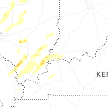
Kentucky
| Local Time | Report Details |
|---|---|
| 12:49 PM CDT | Quarter sized hail reported near Calhoun, KY, 26.2 miles SSE of Evansville, IN |
| 12:50 PM CDT | Quarter sized hail reported near Sebree, KY, 27.5 miles S of Evansville, IN |
| 1:10 PM CDT | Quarter sized hail reported near Owensboro, KY, 27.1 miles SE of Evansville, IN |
| 7:38 PM EDT | Tree down on residential structur in oldham county KY, 27.6 miles NNE of Louisville, KY |
| 7:43 PM EDT | Several trees snapped on highpoint driv in oldham county KY, 29.8 miles NNE of Louisville, KY |
| 7:56 PM EDT | Trees down in smithfield. time estimated from rada in henry county KY, 37.3 miles NE of Louisville, KY |
| 9:02 PM EDT | Time estimated by rada in henry county KY, 37.3 miles NE of Louisville, KY |
| 12:38 AM EDT | Trees down on 2300 block of us42. time estimated from rada in carroll county KY, 48.9 miles SW of Cincinnati, OH |
| 12:40 AM EDT | Trees down on both hawkins and taylor. time estimated from rada in carroll county KY, 46.8 miles SW of Cincinnati, OH |
| 11:40 PM CDT | Tree down across the roadwa in henderson county KY, 12 miles SSE of Evansville, IN |
| 1:06 AM EDT | K8gk awo in gallatin county KY, 37.3 miles SW of Cincinnati, OH |
| 12:13 AM CDT | Building damage... detached garage collapsed... metal in fiel in mclean county KY, 39.4 miles SE of Evansville, IN |
| 12:14 AM CDT | Several trees uprooted north of livermore on 431 between atherton and 108 in mclean county KY, 39.8 miles SE of Evansville, IN |
| 12:14 AM CDT | Tree down and roof off of buildin in mclean county KY, 37.3 miles SSE of Evansville, IN |
| 12:35 AM CDT | Power lines and trees down near walnut and clay street in ohio county KY, 51 miles SE of Evansville, IN |
| 12:35 AM CDT | Power lines and trees down along hamlin chapel r in ohio county KY, 52.5 miles SE of Evansville, IN |
| 12:35 AM CDT | Power lines and trees down along crab tree alle in ohio county KY, 51.4 miles SE of Evansville, IN |
| 1:35 AM CDT | Trees down; frenchman knob rb and locust grove r in hart county KY, 43 miles SSW of Louisville, KY |
| 1:57 AM CDT | Tree down in roadway; new salem roa in green county KY, 51.1 miles S of Louisville, KY |
| 2:07 AM CDT | Tree down in roadway; whitewood r in green county KY, 51.1 miles SSE of Louisville, KY |
| 2:07 AM CDT | Electric pole down; hwy 68 and matney r in green county KY, 57.9 miles S of Louisville, KY |
| 3:07 AM EDT | Two trees were reported down on cave branch road near bethany. the event time is radar estimate in wolfe county KY, 26.8 miles E of Irvine, KY |
| 3:10 AM EDT | Tree down blocking the entire roadway. on lemon bend rd after antle ln and before stubbs r in taylor county KY, 54.6 miles SSE of Louisville, KY |
| 3:12 AM EDT | Power lines leaning up against a tre in taylor county KY, 50.1 miles SSE of Louisville, KY |
| 3:14 AM EDT | Tree down in road in front of harmon furniture blocking all of the roa in taylor county KY, 49.2 miles SSE of Louisville, KY |
| 2:21 AM CDT | Large tree down in roadway; cumberland parkwa in adair county KY, 65.9 miles SSE of Louisville, KY |
| 2:23 AM CDT | Tree blocking roadwa in adair county KY, 64.3 miles SSE of Louisville, KY |
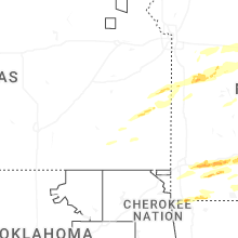
Kansas
| Local Time | Report Details |
|---|---|
| 1:49 PM CDT | Hen Egg sized hail reported near Centerville, KS, 51.6 miles NE of Chanute, KS |
| 2:09 PM CDT | Golf Ball sized hail reported near Moran, KS, 22.5 miles NE of Chanute, KS, public report of golf ball size hail in moran relayed by wfo sgf. em also reported quarter to half-dollar size hail in moran as well. time estimated by radar. |
| 4:05 PM CDT | Quarter sized hail reported near Erie, KS, 17.3 miles SE of Chanute, KS |
Iowa
| Local Time | Report Details |
|---|---|
| 4:31 PM CDT | Quarter sized hail reported near Elma, IA, 46.3 miles E of Mason City, IA |
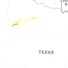
Texas
| Local Time | Report Details |
|---|---|
| 7:18 PM CDT | Quarter sized hail reported near Richardson, TX, 11.1 miles NNE of Dallas, TX, report from mping. |
| 7:18 PM CDT | Quarter sized hail reported near Dallas, TX, 8.5 miles N of Dallas, TX, report from mping. |
| 7:19 PM CDT | Quarter sized hail reported near Richardson, TX, 11.1 miles NNE of Dallas, TX, report from mping. |
| 7:20 PM CDT | Half Dollar sized hail reported near Garland, TX, 13.9 miles NNE of Dallas, TX, report from mping. |
| 7:22 PM CDT | Quarter sized hail reported near Garland, TX, 15.4 miles NNE of Dallas, TX, report from mping. |
| 7:26 PM CDT | Golf Ball sized hail reported near Richardson, TX, 13.9 miles NNE of Dallas, TX, 1.75 inch hail measured in richardson. via email report. |
| 7:29 PM CDT | Half Dollar sized hail reported near Richardson, TX, 13.3 miles NNE of Dallas, TX, report from mping. |
| 7:34 PM CDT | Quarter sized hail reported near Plano, TX, 19.3 miles NE of Dallas, TX, report from mping. |
| 7:37 PM CDT | Quarter sized hail reported near Dallas, TX, 8.9 miles NE of Dallas, TX, report from mping. |
| 7:38 PM CDT | Quarter sized hail reported near Plano, TX, 18.7 miles NE of Dallas, TX, report from mping. |
| 7:43 PM CDT | Half Dollar sized hail reported near Wylie, TX, 23 miles NE of Dallas, TX |
| 7:45 PM CDT | Quarter sized hail reported near Rowlett, TX, 15.2 miles ENE of Dallas, TX, report from mping. |
| 7:47 PM CDT | Quarter sized hail reported near Rowlett, TX, 16.4 miles NE of Dallas, TX, report from mping. |
| 7:52 PM CDT | Hen Egg sized hail reported near Rowlett, TX, 16.1 miles ENE of Dallas, TX, time estimated. |
| 7:52 PM CDT | Golf Ball sized hail reported near Rowlett, TX, 16.1 miles ENE of Dallas, TX, location estimated. |
| 7:56 PM CDT | Quarter sized hail reported near Commerce, TX, 60.8 miles ENE of Dallas, TX |
| 7:57 PM CDT | Half Dollar sized hail reported near Rowlett, TX, 17.3 miles NE of Dallas, TX, report from mping. |
| 8:00 PM CDT | Tea Cup sized hail reported near Commerce, TX, 61.3 miles ENE of Dallas, TX, from a received photo. hail size estimated. time estimated from radar. |
| 8:02 PM CDT | Golf Ball sized hail reported near Commerce, TX, 63.8 miles ENE of Dallas, TX, report from mping. |
| 8:10 PM CDT | Golf Ball sized hail reported near Rockwall, TX, 21.5 miles ENE of Dallas, TX |
| 8:12 PM CDT | Quarter sized hail reported near Celeste, TX, 49.8 miles NE of Dallas, TX |
| 8:21 PM CDT | Golf Ball sized hail reported near Rockwall, TX, 21 miles ENE of Dallas, TX, report from mping. |
| 8:21 PM CDT | Hen Egg sized hail reported near Royse City, TX, 26.6 miles ENE of Dallas, TX, report from mping. |
| 8:22 PM CDT | Ping Pong Ball sized hail reported near Royse City, TX, 26.6 miles ENE of Dallas, TX, report from mping. |
| 8:23 PM CDT | Ping Pong Ball sized hail reported near Fate, TX, 26.6 miles ENE of Dallas, TX, report from mping. |
| 8:45 PM CDT | Ping Pong Ball sized hail reported near Quinlan, TX, 39.2 miles ENE of Dallas, TX, time estimated. |
| 8:50 PM CDT | Golf Ball sized hail reported near Quinlan, TX, 40.2 miles ENE of Dallas, TX, spotter network report. |
| 8:51 PM CDT | Quarter sized hail reported near Honey Grove, TX, 56.3 miles SSE of Atoka, OK, report from mping. |
| 8:57 PM CDT | Quarter sized hail reported near Honey Grove, TX, 56.8 miles SSE of Atoka, OK, report from mping. |
| 5:00 AM CDT | Quarter sized hail reported near Post, TX, 39.1 miles SE of Lubbock, TX, report from social media relayed by broadcast media. |
| 5:00 AM CDT | Hen Egg sized hail reported near Post, TX, 41.8 miles SE of Lubbock, TX, hail estimated slightly larger than golf balls. |
Nevada
| Local Time | Report Details |
|---|---|
| 5:30 PM PDT | Storm damage reported in nye county NV, 68.8 miles NW of Las Vegas, NV |
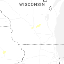
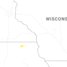
Wisconsin
| Local Time | Report Details |
|---|---|
| 8:22 PM CDT | Quarter sized hail reported near Merrimac, WI, 25.5 miles NNW of Madison, WI |
Mississippi
| Local Time | Report Details |
|---|---|
| 9:23 PM CDT | Quarter sized hail reported near Hickory Flat, MS, 60.9 miles SE of Memphis, TN, 1 inch hail falling in hickory flat. |
| 6:02 AM CDT | Quarter sized hail reported near Paris, MS, 61.6 miles NW of Starkville, MS, quarter sized hail near paris... ms. |
Arkansas
| Local Time | Report Details |
|---|---|
| 10:14 PM CDT | Quarter sized hail reported near Ash Flat, AR, 95 miles S of Salem, MO, report from mping: quarter (1.00 in.). |
| 10:17 PM CDT | Ping Pong Ball sized hail reported near Ash Flat, AR, 97.1 miles S of Salem, MO, report from fire department. |
| 10:55 PM CDT | Thunderstorm wind gust reported near rector. estimated at 60 mp in clay county AR, 78.4 miles N of Memphis, TN |
| 11:29 PM CDT | Golf Ball sized hail reported near Cave City, AR, 88.9 miles NNE of Little Rock, AR |
| 11:50 PM CDT | Quarter sized hail reported near Paragould, AR, 66.4 miles NNW of Memphis, TN, report from mping: quarter (1.00 in.). |
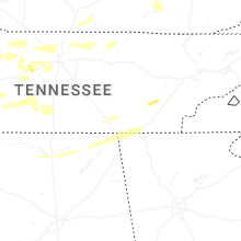
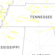
Tennessee
| Local Time | Report Details |
|---|---|
| 11:27 PM CDT | Quarter sized hail reported near Gallatin, TN, 29.1 miles NE of Nashville, TN, report from mping: quarter (1.00 in.). |
| 12:16 AM CDT | Tree down across roadwa in decatur county TN, 48.4 miles SE of Mc Kenzie, TN |
| 12:29 AM CDT | Quarter sized hail reported near Dyersburg, TN, 47.6 miles W of Mc Kenzie, TN, quarter size hail in se dyersburg. |
| 12:30 AM CDT | Quarter sized hail reported near Dickson, TN, 34.9 miles W of Nashville, TN, estimated quarter size hail fell in the dickson area. |
| 12:36 AM CDT | Tree down across hwy 104. radar estimated tim in henderson county TN, 47.3 miles SSE of Mc Kenzie, TN |
| 12:49 AM CDT | Tree down across roadwa in crockett county TN, 39.9 miles WSW of Mc Kenzie, TN |
| 12:51 AM CDT | Half Dollar sized hail reported near Dickson, TN, 34.7 miles W of Nashville, TN, report from mping: half dollar (1.25 in.). |
| 12:57 AM CDT | Large tree down blocking roadway at highway 188 and friendship eaton roa in crockett county TN, 37.5 miles WSW of Mc Kenzie, TN |
| 1:04 AM CDT | Tree across roadwa in crockett county TN, 38.3 miles SW of Mc Kenzie, TN |
| 1:16 AM CDT | Half Dollar sized hail reported near Trenton, TN, 25.8 miles WSW of Mc Kenzie, TN, report from mping: half dollar (1.25 in.). |
| 1:17 AM CDT | Large tree down on the union university campu in madison county TN, 36.6 miles SSW of Mc Kenzie, TN |
| 1:20 AM CDT | Numerous reports of power outages reported in the hohenwald are in lewis county TN, 52.1 miles N of Florence, AL |
| 1:30 AM CDT | Power pole snapped and lines across roadwa in madison county TN, 34.4 miles SSW of Mc Kenzie, TN |
| 1:42 AM CDT | Tree down blocking highway 20 near shady street in summertow in lawrence county TN, 48.7 miles NNE of Florence, AL |
| 1:45 AM CDT | Tree down blocking buffalo road north of buie road in summertow in lawrence county TN, 46.3 miles NNE of Florence, AL |
| 1:45 AM CDT | Trees down in the yard of a home on railroad bed pike as well as a carport blown into the middle of the roa in lawrence county TN, 47.2 miles NNE of Florence, AL |
| 1:47 AM CDT | *** 1 inj *** tree down on car at summertown baptist. driver was injure in lawrence county TN, 48.9 miles NNE of Florence, AL |
| 1:47 AM CDT | Powerlines reported down on dukes park road and stephenson road in summertown. em reporting 1024 customers without power in northern lawrence count in lawrence county TN, 48.8 miles NNE of Florence, AL |
| 1:47 AM CDT | Tree down on power lines at railroad bed pike and highway 20 in summertow in lawrence county TN, 48.5 miles NNE of Florence, AL |
| 1:47 AM CDT | Power poles snapped on moore road in summertow in lawrence county TN, 46.8 miles NNE of Florence, AL |
| 1:47 AM CDT | Tree down on house on grimes loop in summertow in lawrence county TN, 47 miles NNE of Florence, AL |
| 1:47 AM CDT | Trees down blocking the road at barnesville road and railroad bed pike in summertow in lawrence county TN, 47 miles NNE of Florence, AL |
| 2:18 AM CDT | 3000 customers without power in dickson count in dickson county TN, 34.9 miles W of Nashville, TN |
| 2:29 AM CDT | Trees down on browns lake rd near the robertson/davidson county line. minor structural damage. damage collocated with a tornado debris signature off of koh in robertson county TN, 12.7 miles N of Nashville, TN |
| 2:31 AM CDT | Powerlines down in the 3000 block of highway 412 west. trees also blocking highway 13 south near highway 128. time estimate in perry county TN, 50.4 miles SE of Mc Kenzie, TN |
| 2:36 AM CDT | Tree limbs down blocking roadwa in sumner county TN, 13.5 miles NNE of Nashville, TN |
| 2:39 AM CDT | Approximately 800 customers without power in the fairview area and another 800 without power from a transformer fire in grasslan in williamson county TN, 23.1 miles SW of Nashville, TN |
| 2:49 AM CDT | Corrects previous tstm wnd dmg report from 2 ne berry hill. tree down along i-40 at mm 213. time estimated from rada in davidson county TN, 3.3 miles SE of Nashville, TN |
| 3:16 AM CDT | Damage reported along tn-240 sw of summertown. one person trapped in camper... but not injure in lawrence county TN, 48.1 miles NNE of Florence, AL |
| 3:16 AM CDT | Powerlines down in the area of foster avenue in ethridg in lawrence county TN, 41.4 miles NNE of Florence, AL |
| 3:18 AM CDT | Trees down blocking crews roa in lawrence county TN, 38.8 miles NNE of Florence, AL |
| 3:20 AM CDT | Quarter sized hail reported near Memphis, TN, 12.9 miles ENE of Memphis, TN |
| 3:32 AM CDT | Tree struck back of house on good hope road in lawrenceburg. several other trees in the area are dow in lawrence county TN, 39.9 miles NNE of Florence, AL |
| 5:10 AM CDT | Tree down along i-40 at mm 213. time estimated from rada in davidson county TN, 3.3 miles SE of Nashville, TN |
Ohio
| Local Time | Report Details |
|---|---|
| 1:06 AM EDT | Tree fell on lines knocking out powe in montgomery county OH, 48.9 miles NNE of Cincinnati, OH |
| 1:15 AM EDT | Awos station kmwo middletown hook fiel in butler county OH, 29.8 miles NNE of Cincinnati, OH |
Connect with Interactive Hail Maps