

Hail Map for Wednesday, March 23, 2011

Number of Impacted Households on 3/23/2011
0
Impacted by 1" or Larger Hail
0
Impacted by 1.75" or Larger Hail
0
Impacted by 2.5" or Larger Hail
Square Miles of Populated Area Impacted on 3/23/2011
0
Impacted by 1" or Larger Hail
0
Impacted by 1.75" or Larger Hail
0
Impacted by 2.5" or Larger Hail


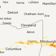


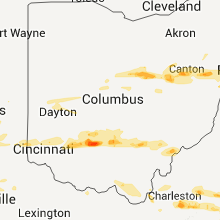


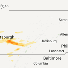


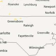
Cities Most Affected by Hail Storms of 3/23/2011
| Hail Size | Demographics of Zip Codes Affected | ||||||
|---|---|---|---|---|---|---|---|
| City | Count | Average | Largest | Pop Density | House Value | Income | Age |
| London, KY | 5 | 1.95 | 2.50 | 116 | $78k | $27.8k | 38.9 |
| Latrobe, PA | 5 | 1.75 | 1.75 | 361 | $87k | $35.1k | 44.2 |
| Pittsburgh, PA | 4 | 1.75 | 1.75 | 4012 | $67k | $29.2k | 33.5 |
| Greenfield, OH | 2 | 1.75 | 1.75 | 96 | $69k | $33.2k | 38.4 |
| Jackson, KY | 2 | 1.75 | 1.75 | 27 | $48k | $19.4k | 39.7 |
| Covington, IN | 2 | 1.75 | 1.75 | 50 | $78k | $44.4k | 43.8 |
| Irwin, PA | 2 | 1.75 | 1.75 | 1040 | $105k | $44.8k | 44.5 |
| Greensburg, PA | 1 | 2.00 | 2.00 | 666 | $103k | $39.9k | 44.6 |
| Beech Grove, IN | 1 | 2.00 | 2.00 | 3913 | $93k | $42.8k | 38.9 |
| Mckeesport, PA | 1 | 2.00 | 2.00 | 3696 | $39k | $24.0k | 42.2 |
| Charleston, WV | 1 | 1.75 | 1.75 | 191 | $62k | $27.9k | 43.7 |
| Stanton, KY | 1 | 1.75 | 1.75 | 58 | $70k | $27.2k | 39.5 |
| Somerset, KY | 1 | 1.75 | 1.75 | 91 | $63k | $24.6k | 41.2 |
| Washington, WV | 1 | 1.75 | 1.75 | 162 | $97k | $49.5k | 44.1 |
| Chillicothe, OH | 1 | 1.75 | 1.75 | 157 | $88k | $37.1k | 39.7 |
| Columbus, OH | 1 | 1.75 | 1.75 | 2976 | $162k | $59.2k | 36.1 |
| Baltic, OH | 1 | 1.75 | 1.75 | 101 | $89k | $34.7k | 25.3 |
| Laurelville, OH | 1 | 1.75 | 1.75 | 42 | $90k | $34.3k | 40.0 |
| Glenmont, OH | 1 | 1.75 | 1.75 | 28 | $71k | $34.8k | 39.6 |
| Hinton, WV | 1 | 1.75 | 1.75 | 49 | $55k | $20.0k | 46.6 |
| New Geneva, PA | 1 | 1.75 | 1.75 | 114 | $0k | $0.0k | 43.5 |
| Athens, OH | 1 | 1.75 | 1.75 | 187 | $107k | $25.9k | 22.4 |
| Odd, WV | 1 | 1.75 | 1.75 | 7 | $16k | $18.8k | 47.3 |
| Indianapolis, IN | 1 | 1.75 | 1.75 | 2909 | $78k | $23.0k | 30.4 |
| Veedersburg, IN | 1 | 1.75 | 1.75 | 32 | $66k | $39.5k | 41.0 |
| Rosedale, VA | 1 | 1.75 | 1.75 | 39 | $96k | $37.4k | 46.8 |
| Russellville, KY | 1 | 1.75 | 1.75 | 75 | $68k | $32.6k | 40.6 |
| Flat Top, WV | 1 | 1.75 | 1.75 | 8 | $94k | $36.6k | 45.1 |
| Parkersburg, WV | 1 | 1.75 | 1.75 | 1032 | $69k | $28.9k | 39.8 |
| Waynetown, IN | 1 | 1.75 | 1.75 | 20 | $80k | $42.1k | 39.4 |
| Ashville, OH | 1 | 1.75 | 1.75 | 133 | $127k | $45.9k | 37.4 |
| Saltsburg, PA | 1 | 1.75 | 1.75 | 94 | $67k | $30.7k | 43.4 |
| New Cumberland, WV | 1 | 1.75 | 1.75 | 128 | $75k | $33.7k | 46.2 |
Hail and Wind Damage Spotted on 3/23/2011
Filter by Report Type:Hail ReportsWind Reports
States Impacted
Indiana, Ohio, Kentucky, Tennessee, Virginia, Pennsylvania, West Virginia, Maryland, North Carolina, GeorgiaIndiana
| Local Time | Report Details |
|---|---|
| 5:48 PM UTC | Quarter sized hail reported near Williams, IN, 71.9 miles SSW of Indianapolis, IN |
| 6:00 PM UTC | Quarter sized hail reported near Rushville, IN, 44.9 miles ESE of Indianapolis, IN, near 450 e and 450 s. 30 homes damaged by hail...including roof...siding and window damage. |
| 6:19 PM UTC | Quarter sized hail reported near Paoli, IN, 59.3 miles NW of Louisville, KY, officers reported hail from dime to quarter size. |
| 6:22 PM UTC | A tree was blown down on 175 w southwest of paol in orange county IN, 56.8 miles NW of Louisville, KY |
| 6:27 PM UTC | Quarter sized hail reported near Liberty, IN, 42.7 miles NNW of Cincinnati, OH |
| 6:52 PM UTC | Hail was covering the ground... vehicles dented in jefferson county IN, 52 miles N of Louisville, KY |
| 7:13 PM UTC | Quarter sized hail reported near Madison, IN, 52.9 miles WSW of Cincinnati, OH |
| 7:35 PM UTC | Pea size hail also reporte in ripley county IN, 44.9 miles W of Cincinnati, OH |
| 10:38 PM UTC | Quarter sized hail reported near Cicero, IN, 25.3 miles NNE of Indianapolis, IN |
| 10:44 PM UTC | Golf Ball sized hail reported near Covington, IN, 69.4 miles NE of Mattoon, IL, emergency manager reports hail ranging from pea sized to golf ball size. |
| 10:55 PM UTC | Golf Ball sized hail reported near Covington, IN, 69.4 miles NE of Mattoon, IL |
| 11:01 PM UTC | Golf Ball sized hail reported near Veedersburg, IN, 63.5 miles WNW of Indianapolis, IN |
| 11:07 PM UTC | Golf Ball sized hail reported near Waynetown, IN, 53.7 miles WNW of Indianapolis, IN |
| 11:24 PM UTC | Quarter sized hail reported near Thorntown, IN, 35 miles NW of Indianapolis, IN |
| 11:25 PM UTC | Half Dollar sized hail reported near Crawfordsville, IN, 44.1 miles WNW of Indianapolis, IN, 1.25 inch hail...wall cloud also observed. |
| 11:32 PM UTC | Quarter sized hail reported near Thorntown, IN, 31.8 miles NW of Indianapolis, IN, near 600 w and 200 n. |
| 11:33 PM UTC | Quarter sized hail reported near New Ross, IN, 33.2 miles WNW of Indianapolis, IN, emergency manager reports dime to quarter sized hail at 1000 e and 400 s. |
| 11:40 PM UTC | Ping Pong Ball sized hail reported near Lebanon, IN, 25.9 miles NW of Indianapolis, IN, reported in northwest lebanon. |
| 11:47 PM UTC | Quarter sized hail reported near Lebanon, IN, 25.9 miles NW of Indianapolis, IN, east side of lebanon. |
| 11:53 PM UTC | Quarter sized hail reported near Westfield, IN, 19.6 miles N of Indianapolis, IN, quarter sized hail at hwy 32 and spring mill rd. |
| 12:00 AM UTC | Ping Pong Ball sized hail reported near Noblesville, IN, 21.2 miles NNE of Indianapolis, IN, eastern noblesville near the intersection of 32 and 37. |
| 12:00 AM UTC | Garage blown i in rush county IN, 35.3 miles ESE of Indianapolis, IN |
| 12:00 AM UTC | Tree down on roa in rush county IN, 35.3 miles ESE of Indianapolis, IN |
| 12:03 AM UTC | Quarter sized hail reported near Avon, IN, 12.3 miles W of Indianapolis, IN |
| 12:07 AM UTC | Quarter sized hail reported near Avon, IN, 12.3 miles W of Indianapolis, IN |
| 12:13 AM UTC | Quarter sized hail reported near Indianapolis, IN, 6.7 miles SW of Indianapolis, IN |
| 12:20 AM UTC | Half Dollar sized hail reported near Indianapolis, IN, 0.5 miles S of Indianapolis, IN |
| 12:30 AM UTC | Golf Ball sized hail reported near Indianapolis, IN, 0.9 miles N of Indianapolis, IN, east indianapolis...near raymond and franklin. |
| 12:30 AM UTC | Hen Egg sized hail reported near Beech Grove, IN, 4.5 miles SE of Indianapolis, IN, near 4th and buffalo ave in beech grove. |
| 12:36 AM UTC | Quarter sized hail reported near New Palestine, IN, 14.2 miles ESE of Indianapolis, IN |
| 12:42 AM UTC | Quarter sized hail reported near Lebanon, IN, 27.3 miles NW of Indianapolis, IN, reported 1 s of highway 32. |
| 1:10 AM UTC | Quarter sized hail reported near Carthage, IN, 33 miles E of Indianapolis, IN, at sr 140 and rushville rd. |
| 1:18 AM UTC | Quarter sized hail reported near Connersville, IN, 48.4 miles E of Indianapolis, IN, numerous reports of pea to quarter sized hail. |
| 1:41 AM UTC | Quarter sized hail reported near Osgood, IN, 42.2 miles W of Cincinnati, OH |
| 2:00 AM UTC | Numerous power outages between whiteland and greenwoo in johnson county IN, 13.3 miles SSE of Indianapolis, IN |
Ohio
| Local Time | Report Details |
|---|---|
| 6:02 PM UTC | Quarter sized hail reported near Cincinnati, OH, 15.7 miles NNE of Cincinnati, OH |
| 6:07 PM UTC | 2 trees dow in butler county OH, 29.2 miles NNE of Cincinnati, OH |
| 6:29 PM UTC | Half Dollar sized hail reported near Blanchester, OH, 31.8 miles ENE of Cincinnati, OH |
| 6:35 PM UTC | Quarter sized hail reported near Mt Gilead, OH, 41.5 miles NNE of Columbus, OH |
| 6:43 PM UTC | Quarter sized hail reported near Washington Court House, OH, 36.9 miles SW of Columbus, OH |
| 3:04 PM EDT | Golf Ball sized hail reported near Greenfield, OH, 47 miles SSW of Columbus, OH |
| 7:05 PM UTC | Quarter sized hail reported near Prospect, OH, 35.1 miles NNW of Columbus, OH |
| 7:05 PM UTC | Quarter sized hail reported near Hamilton, OH, 20.9 miles NNW of Cincinnati, OH, hail at least the size of quarters. time and size of hail estimated. |
| 7:08 PM UTC | Quarter sized hail reported near Butler, OH, 53.4 miles NNE of Columbus, OH |
| 7:12 PM UTC | Golf Ball sized hail reported near Ashville, OH, 16.9 miles S of Columbus, OH |
| 7:15 PM UTC | Half Dollar sized hail reported near Covington, OH, 69 miles N of Cincinnati, OH |
| 7:18 PM UTC | Ping Pong Ball sized hail reported near Frankfort, OH, 39.9 miles SSW of Columbus, OH |
| 7:18 PM UTC | *** 1 inj *** a large tree was blown down on a car. one person in the car was injure in hamilton county OH, 11 miles ENE of Cincinnati, OH |
| 7:20 PM UTC | Quarter sized hail reported near Loudonville, OH, 61.6 miles NE of Columbus, OH |
| 7:21 PM UTC | Quarter sized hail reported near Clarksville, OH, 36.8 miles NE of Cincinnati, OH |
| 7:26 PM UTC | Half Dollar sized hail reported near Fredericktown, OH, 43 miles NNE of Columbus, OH |
| 7:30 PM UTC | Quarter sized hail reported near North Canton, OH, 46.3 miles SSE of Cleveland, OH |
| 7:31 PM UTC | Quarter sized hail reported near Steubenville, OH, 34.7 miles W of Pittsburgh, PA |
| 7:31 PM UTC | Golf Ball sized hail reported near Chillicothe, OH, 41.6 miles S of Columbus, OH |
| 7:34 PM UTC | Quarter sized hail reported near Salineville, OH, 47.9 miles WNW of Pittsburgh, PA |
| 3:34 PM EDT | Golf Ball sized hail reported near Greenfield, OH, 47 miles SSW of Columbus, OH |
| 7:35 PM UTC | Quarter sized hail reported near Troy, OH, 64.8 miles W of Columbus, OH |
| 7:35 PM UTC | Quarter sized hail reported near Millersburg, OH, 65.3 miles S of Cleveland, OH |
| 7:36 PM UTC | Quarter sized hail reported near North Lewisburg, OH, 34.5 miles WNW of Columbus, OH, dime to quarter size hail |
| 7:38 PM UTC | Golf Ball sized hail reported near Laurelville, OH, 37.2 miles SSE of Columbus, OH |
| 7:39 PM UTC | Quarter sized hail reported near Kingston, OH, 37.2 miles S of Columbus, OH, between dry run road and state route 180. |
| 7:40 PM UTC | Large branches broke in clermont county OH, 15.8 miles SE of Cincinnati, OH |
| 7:44 PM UTC | Half Dollar sized hail reported near Millersburg, OH, 66.2 miles S of Cleveland, OH |
| 7:44 PM UTC | Half Dollar sized hail reported near Martinsville, OH, 40.1 miles ENE of Cincinnati, OH |
| 7:48 PM UTC | Power pole blown down near us 22 and miami trace roa in fayette county OH, 43.2 miles SW of Columbus, OH |
| 7:50 PM UTC | Ping Pong Ball sized hail reported near Bergholz, OH, 45.3 miles W of Pittsburgh, PA, near burgholtz |
| 7:55 PM UTC | Ping Pong Ball sized hail reported near Dover, OH, 68.9 miles S of Cleveland, OH |
| 7:55 PM UTC | Golf Ball sized hail reported near Glenmont, OH, 61.7 miles NE of Columbus, OH, spotter measured 1.75 inch hail. |
| 8:00 PM UTC | Quarter sized hail reported near Hanoverton, OH, 54.3 miles WNW of Pittsburgh, PA |
| 8:00 PM UTC | Quarter sized hail reported near Creola, OH, 50.9 miles SE of Columbus, OH |
| 8:01 PM UTC | Quarter sized hail reported near Westerville, OH, 13 miles NNE of Columbus, OH, nickel to quarter sized hail for about 5-10 minutes. |
| 8:01 PM UTC | Roof blown off a garage on fair ridge roa in highland county OH, 47.7 miles E of Cincinnati, OH |
| 8:02 PM UTC | *** 1 inj *** a greenhouse collapsed near state route 73 in berrysville. one injury occurred when a woman was trapped insid in highland county OH, 50.8 miles E of Cincinnati, OH |
| 8:03 PM UTC | Trees downed in the fairfax are in highland county OH, 48.2 miles E of Cincinnati, OH |
| 8:05 PM UTC | Possible collapse of a greenhouse. injuries unknown at this tim in highland county OH, 51.4 miles E of Cincinnati, OH |
| 8:05 PM UTC | Golf Ball sized hail reported near Columbus, OH, 11.1 miles N of Columbus, OH, marble to golf ball sized hail |
| 8:08 PM UTC | A commercial barns entire frame was blown 50 feet from its foundatio in adams county OH, 48.3 miles ESE of Cincinnati, OH |
| 8:10 PM UTC | Storm damage reported in brown county OH, 41.8 miles ESE of Cincinnati, OH |
| 8:10 PM UTC | Storm damage reported in adams county OH, 50.4 miles ESE of Cincinnati, OH |
| 8:13 PM UTC | Quarter sized hail reported near Columbiana, OH, 46.6 miles NW of Pittsburgh, PA |
| 8:15 PM UTC | Golf Ball sized hail reported near Athens, OH, 61.2 miles SE of Columbus, OH, spotter had yard covered with golf ball sized hail...reported damage to car |
| 8:20 PM UTC | Golf Ball sized hail reported near Baltic, OH, 73.5 miles S of Cleveland, OH |
| 8:25 PM UTC | Penny size hail also reporte in brown county OH, 50.3 miles SE of Cincinnati, OH |
| 8:27 PM UTC | 55mph gust reported...sheeting falling off houses...branches off trees...and several trees falling down in lawrence county OH, 40.7 miles W of Charleston, WV |
| 8:28 PM UTC | Quarter sized hail reported near Coshocton, OH, 64.4 miles ENE of Columbus, OH |
| 8:30 PM UTC | Half Dollar sized hail reported near Irondale, OH, 39.6 miles WNW of Pittsburgh, PA |
| 8:33 PM UTC | Quarter sized hail reported near Salineville, OH, 45.6 miles WNW of Pittsburgh, PA |
| 8:34 PM UTC | Trees and power lines down in adams county OH, 59.9 miles E of Cincinnati, OH |
| 8:34 PM UTC | House trailer being towed blown over in pike county OH, 65.7 miles S of Columbus, OH |
| 8:35 PM UTC | Power lines down on big run road just east of sr 2 in pike county OH, 67.7 miles S of Columbus, OH |
| 8:38 PM UTC | *** 1 fatal *** a tree fell on a child who was inside a tent at a boy scout camp in the shawnee state forest. fatality time is estimated. corrected time from previous r in scioto county OH, 78.5 miles ESE of Cincinnati, OH |
| 8:40 PM UTC | Several trees reported down around athens township in athens county OH, 65 miles SE of Columbus, OH |
| 8:42 PM UTC | Numerous trees down and power outage in scioto county OH, 76.4 miles WNW of Charleston, WV |
| 8:42 PM UTC | *** 1 fatal *** corrected report. a woman in her 20s was killed by a falling tree while she was camping at the shawnee state forest. earlier reports of a child killed a in scioto county OH, 74.2 miles ESE of Cincinnati, OH |
| 8:55 PM UTC | Quarter sized hail reported near Little Hocking, OH, 60.8 miles N of Charleston, WV |
| 9:00 PM UTC | Barn lifted off of ground with concrete...outbuilding picked up and blown across street...roof blown off home...numerous trees and power lines down in jackson county OH, 64.3 miles NW of Charleston, WV |
| 9:15 PM UTC | Town of willow wood in lawrence county OH, 48.4 miles WNW of Charleston, WV |
| 9:27 PM UTC | 55mph gust reported...sheeting falling off houses...branches off trees...and several trees falling down in lawrence county OH, 40.7 miles W of Charleston, WV |
| 2:52 AM UTC | Quarter sized hail reported near West Union, OH, 53.2 miles ESE of Cincinnati, OH |
| 2:54 AM UTC | Quarter sized hail reported near West Union, OH, 56.4 miles ESE of Cincinnati, OH, nickel to quarter size |
| 3:50 AM UTC | Quarter sized hail reported near Proctorville, OH, 39.8 miles WNW of Charleston, WV |
Kentucky
| Local Time | Report Details |
|---|---|
| 6:30 PM UTC | Quarter sized hail reported near Morganfield, KY, 27.9 miles SW of Evansville, IN, quarter sized hail reported in the east side of morganfield...reported by weht. |
| 7:12 PM UTC | Numerous tree limbs down in kenton county KY, 11.1 miles SSW of Cincinnati, OH |
| 7:25 PM UTC | A few small structures and sheds were blown off their foundation in gallatin county KY, 33.5 miles SW of Cincinnati, OH |
| 7:33 PM UTC | Quarter sized hail reported near Radcliff, KY, 16.3 miles SW of Louisville, KY, pea to quarter sized hail reported |
| 7:35 PM UTC | Pea size hail also reported. corrected count in gallatin county KY, 28.4 miles SSW of Cincinnati, OH |
| 7:43 PM UTC | Damage to barn with the metal roof found in the road on hwy 69 in barren county KY, 68.5 miles NE of Nashville, TN |
| 7:44 PM UTC | Quarter sized hail reported near Owensboro, KY, 29.9 miles SE of Evansville, IN, nickel to quarter sized |
| 7:49 PM UTC | Quarter sized hail reported near Falls of Rough, KY, 48.2 miles WSW of Louisville, KY |
| 7:55 PM UTC | Quarter sized hail reported near Garfield, KY, 38 miles WSW of Louisville, KY |
| 7:57 PM UTC | Roof of ferry blown off. also small trees down along route in bracken county KY, 35.8 miles SE of Cincinnati, OH |
| 8:00 PM UTC | Multiple instances of damage in gertrude area. tin roofing blown away. rafters and sheet metal blown off buildings. part of porch blown away from trailer. corner of bar in bracken county KY, 34.5 miles SE of Cincinnati, OH |
| 8:08 PM UTC | Two utility poles snapped off on route 19. three-foot diameter tree fell down on electric lines on woodland acres r in bracken county KY, 37.6 miles SE of Cincinnati, OH |
| 8:23 PM UTC | One tree down on power lines on calk lake road. one tree down on old nest egg...near kentucky 1 in montgomery county KY, 20.2 miles NNE of Irvine, KY |
| 8:23 PM UTC | 2 utility poles down near the intersection of hwy 70 and fred fackler r in meade county KY, 26.1 miles W of Louisville, KY |
| 8:30 PM UTC | Golf Ball sized hail reported near Stanton, KY, 18 miles NE of Irvine, KY |
| 8:35 PM UTC | Trees down on highway 77 near red river gorge entrance. school bus trapped between downed tree in menifee county KY, 22.7 miles ENE of Irvine, KY |
| 8:40 PM UTC | Quarter sized hail reported near Frenchburg, KY, 24.2 miles NE of Irvine, KY, hail covered the ground. |
| 8:44 PM UTC | Quarter sized hail reported near Frenchburg, KY, 28.9 miles NE of Irvine, KY, hail occurred at highway 460 e. |
| 8:48 PM UTC | Quarter sized hail reported near West Liberty, KY, 41.2 miles ENE of Irvine, KY |
| 8:58 PM UTC | Quarter sized hail reported near Hopkinsville, KY, 66.6 miles NW of Nashville, TN, 1 inch hail report just east-southeast of kelly in christian county. |
| 8:58 PM UTC | Quarter sized hail reported near West Liberty, KY, 41.2 miles ENE of Irvine, KY |
| 8:58 PM UTC | One tree down on power lines on calk lake road. one tree down on old nest egg...near kentucky 1 in montgomery county KY, 20.2 miles NNE of Irvine, KY |
| 9:11 PM UTC | Quarter sized hail reported near Gravel Switch, KY, 46.1 miles SE of Louisville, KY, quarter sized hail... covering the ground |
| 9:17 PM UTC | Quarter sized hail reported near Knifley, KY, 60 miles SSE of Louisville, KY |
| 9:19 PM UTC | Quarter sized hail reported near Danville, KY, 43.8 miles W of Irvine, KY, quarter sized hail reported via dispatch |
| 9:25 PM UTC | Strong winds damaged 300 feet of chain link fence just north of russellville. several trees were downed around 5 miles north of russellvill in logan county KY, 51.6 miles N of Nashville, TN |
| 9:30 PM UTC | Golf Ball sized hail reported near Russellville, KY, 46.8 miles N of Nashville, TN, golf ball sized hail reported |
| 9:30 PM UTC | Golf ball sized hail reported in logan county KY, 46.8 miles N of Nashville, TN |
| 9:30 PM UTC | Trees down at the intersection of main st. and armory dr. as well as near epley station along u.s. 431 in logan county KY, 46.8 miles N of Nashville, TN |
| 9:37 PM UTC | Quarter sized hail reported near Liberty, KY, 63.5 miles WSW of Irvine, KY, spotter reports nickel to quarter sized hail near the intersection of u.s. 127 and hwy 910 |
| 9:44 PM UTC | 12 to 14 inch diameter trees snapped off. some pea size hail. trained spotter was at the lee county high school in beattyville. winds were reported at least 70 mp in lee county KY, 16.7 miles ESE of Irvine, KY |
| 9:48 PM UTC | One downed tree blocking roa in martin county KY, 58.6 miles WSW of Charleston, WV |
| 9:48 PM UTC | One tree blocking roa in martin county KY, 58.6 miles WSW of Charleston, WV |
| 9:48 PM UTC | One tree uprooted. also dime sized hai in martin county KY, 61.5 miles WSW of Charleston, WV |
| 9:48 PM UTC | Two trees uprooted. also nickel sized hai in martin county KY, 56.3 miles WSW of Charleston, WV |
| 9:49 PM UTC | Spotter reports dime sized hail... estimated 60-70 mph winds... and trees down by the roots near 31w and hwy 240 in warren county KY, 48.9 miles NNE of Nashville, TN |
| 9:50 PM UTC | Trailer blown to pieces and numerous trees down on mooretown road just off of highway 5 in lee county KY, 18.6 miles ESE of Irvine, KY |
| 9:55 PM UTC | Structural damage reported...portions of a roof blown off a house and porch furniture damaged in boyd county KY, 54.9 miles W of Charleston, WV |
| 9:55 PM UTC | Quarter sized hail reported near Center, KY, 62.6 miles S of Louisville, KY |
| 9:57 PM UTC | Roof blown off of a barn on hwy 73 near mm18 in simpson county KY, 40.5 miles NNE of Nashville, TN |
| 9:57 PM UTC | Trees down near drake in warren county KY, 50.7 miles NNE of Nashville, TN |
| 9:59 PM UTC | Trees down near temperance in simpson county KY, 46.5 miles NNE of Nashville, TN |
| 10:00 PM UTC | Quarter sized hail reported near Glasgow, KY, 64.4 miles NE of Nashville, TN, one inch hail lasted for 15 minutes. |
| 10:00 PM UTC | Quarter sized hail reported near Jackson, KY, 33.5 miles ESE of Irvine, KY |
| 10:05 PM UTC | Quarter sized hail reported near Scottsville, KY, 58.4 miles NE of Nashville, TN, quarter sized hail reported near cedar springs |
| 10:08 PM UTC | Half Dollar sized hail reported near Science Hill, KY, 51.2 miles SW of Irvine, KY, event time was corrected. hail occurred around 610 pm. |
| 10:09 PM UTC | Quarter sized hail reported near Austin, KY, 61.7 miles NE of Nashville, TN |
| 10:09 PM UTC | Quarter sized hail reported near Scottsville, KY, 51.5 miles NE of Nashville, TN, spotter reports quarter sized hail and relays several reports of trees down...including one that had fallen on a moving vehicle on old hartsville road |
| 10:09 PM UTC | Spotter reports quarter sized hail and relays several reports of trees down...including one that had fallen on a moving vehicle on old hartsville road in allen county KY, 51.5 miles NE of Nashville, TN |
| 10:10 PM UTC | The top half of a large healthy pine tree was snapped off by thunderstorm wind gust in breathitt county KY, 34 miles ESE of Irvine, KY |
| 10:10 PM UTC | Large pine tree was snapped off by thunderstorm wind causing damage to a hous in breathitt county KY, 33.5 miles ESE of Irvine, KY |
| 10:10 PM UTC | Golf Ball sized hail reported near Jackson, KY, 34 miles ESE of Irvine, KY, golf ball sized hail at lakeside. |
| 10:11 PM UTC | Quarter sized hail reported near Somerset, KY, 50.5 miles SW of Irvine, KY |
| 10:13 PM UTC | Quarter sized hail reported near Austin, KY, 64.7 miles NE of Nashville, TN, quarter sized hail reported near dry fork |
| 10:15 PM UTC | Spotter reports damage to trailer with trees down near 31e and cartertown rd. estimated winds to be around 70 to 80 mph in allen county KY, 51.5 miles NE of Nashville, TN |
| 10:15 PM UTC | Golf Ball sized hail reported near Jackson, KY, 34 miles ESE of Irvine, KY |
| 10:17 PM UTC | Golf Ball sized hail reported near Somerset, KY, 55.2 miles SW of Irvine, KY, event occurred between 602 pm and 617 pm. |
| 10:30 PM UTC | Two to three trees dow in laurel county KY, 36.1 miles SSW of Irvine, KY |
| 10:32 PM UTC | Half Dollar sized hail reported near Science Hill, KY, 51.2 miles SW of Irvine, KY, event occurred between 617 and 632 pm. |
| 10:32 PM UTC | A tree was blown down on a powerlin in floyd county KY, 63.4 miles E of Irvine, KY |
| 10:34 PM UTC | Ping Pong Ball sized hail reported near Tompkinsville, KY, 70.9 miles ENE of Nashville, TN, spotter reports hail just under golf ball size |
| 10:35 PM UTC | Quarter sized hail reported near Burkesville, KY, 84.8 miles SSE of Louisville, KY |
| 10:37 PM UTC | Golf Ball sized hail reported near London, KY, 40.5 miles SSW of Irvine, KY |
| 10:39 PM UTC | Quarter sized hail reported near Tompkinsville, KY, 70.9 miles ENE of Nashville, TN, spotter reports pea to quarter sized hail |
| 10:40 PM UTC | Golf Ball sized hail reported near London, KY, 41.9 miles S of Irvine, KY |
| 6:40 PM EDT | Golf Ball sized hail reported near London, KY, 44.8 miles SSW of Irvine, KY |
| 10:40 PM UTC | Hen Egg sized hail reported near London, KY, 39.9 miles S of Irvine, KY |
| 10:42 PM UTC | Half Dollar sized hail reported near London, KY, 41 miles S of Irvine, KY |
| 10:43 PM UTC | Half Dollar sized hail reported near London, KY, 39.7 miles S of Irvine, KY, event occurred between 643 pm and 658 pm. |
| 6:45 PM EDT | Tennis Ball sized hail reported near London, KY, 41.1 miles S of Irvine, KY |
| 10:55 PM UTC | A few trees down in clinton county KY, 86.5 miles SSE of Louisville, KY |
| 10:59 PM UTC | Trees down blocking highway 194 at the mouth of bevins branc in pike county KY, 66.9 miles N of Bristol, TN |
| 11:08 PM UTC | Several trees down blocking highway 105 in pike county KY, 63.4 miles SSW of Charleston, WV |
| 11:10 PM UTC | Tree down on long fork road blocking traffi in pike county KY, 62 miles N of Bristol, TN |
| 11:20 PM UTC | Tree and power lines down at little card roa in pike county KY, 54.4 miles N of Bristol, TN |
| 11:25 PM UTC | 1 tree down on highway 26 north of jacks fork road in whitley county KY, 59.6 miles N of Knoxville, TN |
| 11:50 PM UTC | Roof blown off of a porch attached to a trailer and a shed was blown onto highway 159 in whitley county KY, 48.3 miles N of Knoxville, TN |
Tennessee
| Local Time | Report Details |
|---|---|
| 7:00 PM UTC | Ping Pong Ball sized hail reported near Sparta, TN, 65.3 miles N of Chattanooga, TN, public rpt of broken car windows |
| 7:10 PM UTC | Ping Pong Ball sized hail reported near Sparta, TN, 65.3 miles N of Chattanooga, TN, public rpt of broken car windows |
| 7:32 PM UTC | Quarter sized hail reported near Crossville, TN, 62.7 miles W of Knoxville, TN, quarter size hail on highway 70n. |
| 8:45 PM UTC | Couple trees dow in knox county TN, 1.8 miles WNW of Knoxville, TN |
| 9:00 PM UTC | Quarter sized hail reported near Elizabethton, TN, 14 miles SSE of Bristol, TN, quarter size hail reported by dispatch on highway 91. |
| 10:42 PM UTC | Quarter sized hail reported near Mt Juliet, TN, 16.9 miles E of Nashville, TN, reported near west wilson school on lebanon road. |
| 10:45 PM UTC | Trees down in the butler area reported by hwy dept and tdo in johnson county TN, 22.3 miles SE of Bristol, TN |
| 11:20 PM UTC | Barn blown down on old alexanria road. ema en route to survey damag in wilson county TN, 37.9 miles E of Nashville, TN |
| 11:20 PM UTC | Roof blown off a home on haley roa in wilson county TN, 38.8 miles E of Nashville, TN |
| 11:29 PM UTC | Quarter sized hail reported near Monroe, TN, 81.6 miles WNW of Knoxville, TN, quarter sized hail reported near monroe. |
| 11:35 PM UTC | Quarter sized hail reported near Brush Creek, TN, 42 miles E of Nashville, TN, trained spotter rpt quarter sized hail. |
| 11:40 PM UTC | Structure roof damage on dooley road in lawrence county TN, 43.4 miles NNE of Florence, AL |
| 11:41 PM UTC | Quarter sized hail reported near Jamestown, TN, 68 miles WNW of Knoxville, TN |
| 12:10 AM UTC | Trees down in christian in rutherford county TN, 37.8 miles SE of Nashville, TN |
| 12:15 AM UTC | Several trees dow in campbell county TN, 29.9 miles NW of Knoxville, TN |
| 12:45 AM UTC | Tree reported down on gattistown road. substation was also hit resulting in 781 residents briefly without powe in lincoln county TN, 62.8 miles W of Chattanooga, TN |
| 12:50 AM UTC | Trees reported down in hillsbor in coffee county TN, 44.7 miles WNW of Chattanooga, TN |
| 1:05 AM UTC | One tree down at blaine. reported by dispatc in grainger county TN, 17.9 miles NE of Knoxville, TN |
| 1:05 AM UTC | One tree down at washburn. reported by dispatc in grainger county TN, 27.9 miles NE of Knoxville, TN |
| 1:10 AM UTC | One tree down at spring hill and one tree down at buffet mills. reported by dispatc in knox county TN, 1.8 miles WNW of Knoxville, TN |
| 1:20 AM UTC | One tree down on hwy 346 in surgoinsville. reported by dispatc in hawkins county TN, 36.5 miles WSW of Bristol, TN |
| 1:20 AM UTC | One tree down on ebbing flowing springs rd. reported by dispatc in hawkins county TN, 43.7 miles WSW of Bristol, TN |
| 1:34 AM UTC | One tree down in del rio. reported by dispatc in cocke county TN, 50 miles E of Knoxville, TN |
| 1:35 AM UTC | One tree down on the spur-hwy 441 between gatlinburg and pigeon forge. reported by dispatc in sevier county TN, 29.3 miles SE of Knoxville, TN |
| 1:35 AM UTC | One tree down on river devide rd. reported by dispatc in sevier county TN, 19.7 miles ESE of Knoxville, TN |
| 1:50 AM UTC | Possible tornado reported by dispatch...mutiple power lines and trees down on hwy 95 also damage to roof of hous in loudon county TN, 25.9 miles SW of Knoxville, TN |
| 1:55 AM UTC | *** 1 inj *** possible tornado...3 story house destroyed and roof blown off another hous in loudon county TN, 24.7 miles SSW of Knoxville, TN |
| 1:57 AM UTC | Possible tornado reported by ham...multiple trees down and possible injuries on janeway r in blount county TN, 25.1 miles SSW of Knoxville, TN |
| 5:20 AM UTC | Quarter sized hail reported near Bluff City, TN, 9.5 miles SSW of Bristol, TN, quarter size hail reported by spotter. |
Virginia
| Local Time | Report Details |
|---|---|
| 7:25 PM UTC | Quarter sized hail reported near Pennington Gap, VA, 46.4 miles WNW of Bristol, TN, quarter size hail reported by public. |
| 9:07 PM UTC | Quarter sized hail reported near Lexington, VA, 48.4 miles NE of Roanoke, VA, quarter size hail |
| 9:30 PM UTC | Many branches down from thunderstorm wind gusts in heavy rain in augusta county VA, 53.6 miles SSE of Elkins, WV |
| 9:31 PM UTC | Quarter sized hail reported near Patrick Springs, VA, 36.8 miles SSW of Roanoke, VA |
| 10:00 PM UTC | Numerous trees down...power lines down near intersection of mulberry road and sam lions road in city of martinsvil county VA, 41 miles S of Roanoke, VA |
| 10:00 PM UTC | Quarter sized hail reported near Martinsville, VA, 41 miles S of Roanoke, VA, numerous trees down...power lines down near intersection of mulberry road and sam lions road |
| 10:05 PM UTC | Tree down across callands rd in pittsylvania county VA, 41.1 miles SE of Roanoke, VA |
| 10:09 PM UTC | Tree down in pittsylvania county VA, 44 miles SE of Roanoke, VA |
| 10:09 PM UTC | Tree down on power line in pittsylvania county VA, 43.5 miles SE of Roanoke, VA |
| 10:13 PM UTC | Tree down across road in pittsylvania county VA, 43.4 miles SE of Roanoke, VA |
| 10:20 PM UTC | Tree down in pittsylvania county VA, 44 miles SE of Roanoke, VA |
| 10:23 PM UTC | Power pole broken in pittsylvania county VA, 42.8 miles SE of Roanoke, VA |
| 10:25 PM UTC | Tree down on residence in city of danville county VA, 56 miles SSE of Roanoke, VA |
| 10:25 PM UTC | Tree down in pittsylvania county VA, 44.3 miles SE of Roanoke, VA |
| 10:25 PM UTC | Part of roof of trailer home blown off at 5225 kentuck r in pittsylvania county VA, 55.3 miles SE of Roanoke, VA |
| 10:25 PM UTC | Roof blown off residence in pittsylvania county VA, 55.1 miles SE of Roanoke, VA |
| 10:32 PM UTC | Tree down across road in pittsylvania county VA, 49.3 miles SE of Roanoke, VA |
| 10:35 PM UTC | A couple of trees down at 8167 and 11000 block of james d hagood highway...highway 360 in halifax county VA, 69.1 miles N of Raleigh, NC |
| 10:40 PM UTC | Tree down near intersection of highway 360 and piney creek road in halifax county VA, 69.6 miles N of Raleigh, NC |
| 10:58 PM UTC | Tree down on house in pittsylvania county VA, 42.6 miles SE of Roanoke, VA |
| 11:00 PM UTC | Trees and telephone wires dow in highland county VA, 48.6 miles S of Elkins, WV |
| 11:03 PM UTC | Tree down in pittsylvania county VA, 48.8 miles SE of Roanoke, VA |
| 11:13 PM UTC | Large tree down in patrick county VA, 48.1 miles SSW of Roanoke, VA |
| 11:20 PM UTC | Pwer lines down in pittsylvania county VA, 45.1 miles SE of Roanoke, VA |
| 11:20 PM UTC | Quarter sized hail reported near King George, VA, 57.9 miles NNE of Richmond, VA, time estimated |
| 11:25 PM UTC | Svrl lrge trees snapped in rockingham county VA, 60.7 miles ESE of Elkins, WV |
| 11:26 PM UTC | Power lines down across broadway avenu in rockingham county VA, 60.9 miles ESE of Elkins, WV |
| 11:26 PM UTC | Tree knocked down and damaging a gutter on side of a house in eqypt bend estates subdivisio in page county VA, 74 miles ESE of Elkins, WV |
| 11:26 PM UTC | Trees knocked down onto powerlines causing a small fire in eqypt bend estates subdivisio in page county VA, 74 miles ESE of Elkins, WV |
| 11:26 PM UTC | Trees knocked down along yaegers roa in page county VA, 76.6 miles ESE of Elkins, WV |
| 11:27 PM UTC | Thunderstorm winds knocked down powerlines near 3600 dry run road to the east-southeast of lura in page county VA, 79.6 miles ESE of Elkins, WV |
| 11:27 PM UTC | Trees knocked down onto a few vehicles in eqypt bend estates subdivision. no injurie in page county VA, 74 miles ESE of Elkins, WV |
| 11:28 PM UTC | Large tree knocked down from thunderstorm winds. limbs of tree fell onto power lines and knocked them down near east point road and bethel church road in rockingham county VA, 72.5 miles ESE of Elkins, WV |
| 11:29 PM UTC | Trees and powerlines down in rockingham county VA, 75.1 miles ESE of Elkins, WV |
| 11:29 PM UTC | Several trees... up to 1 foot in diameter... knocked down from thunderstorm winds north of rt 211 in page county VA, 73.1 miles ESE of Elkins, WV |
| 11:29 PM UTC | Trees knocked down along bixlers ferry road in page county VA, 76.2 miles ESE of Elkins, WV |
| 11:30 PM UTC | Quarter sized hail reported near , , 50.6 miles N of Roanoke, VA, mature tree down and quarter size hail |
| 11:30 PM UTC | Mature tree down and quarter size hail in bath county VA, 50.6 miles N of Roanoke, VA |
| 11:35 PM UTC | Thunderstorm winds knocked down powerlines near 3600 dry run road to the east-southeast of lura in page county VA, 79.6 miles ESE of Elkins, WV |
| 11:35 PM UTC | Tree knocked down and damaging a gutter on side of a house in eqypt bend estates subdivisio in page county VA, 74 miles ESE of Elkins, WV |
| 11:35 PM UTC | Trees knocked down onto a few vehicles in eqypt bend estates subdivision. no injurie in page county VA, 74 miles ESE of Elkins, WV |
| 11:35 PM UTC | Trees knocked down onto powerlines causing a small fire in eqypt bend estates subdivisio in page county VA, 74 miles ESE of Elkins, WV |
| 11:35 PM UTC | Trees knocked down along yaegers roa in page county VA, 76.6 miles ESE of Elkins, WV |
| 11:35 PM UTC | Several trees... up to 1 foot in diameter... knocked down from thunderstorm winds north of rt 211 in page county VA, 73.1 miles ESE of Elkins, WV |
| 11:37 PM UTC | Trees knocked down onto a few vehicles in eqypt bend estates subdivision. no injurie in page county VA, 74 miles ESE of Elkins, WV |
| 11:39 PM UTC | Large tree knocked down from thunderstorm winds. limbs of tree fell onto power lines and knocked them down near east point road and bethel church road in rockingham county VA, 72.5 miles ESE of Elkins, WV |
| 11:40 PM UTC | Storm damage reported in page county VA, 74.7 miles ESE of Elkins, WV |
| 11:40 PM UTC | Several trees... up to 1 foot in diameter... knocked down from thunderstorm winds north of rt 211 in page county VA, 73.1 miles ESE of Elkins, WV |
| 11:40 PM UTC | Two trees dow in page county VA, 79.2 miles ESE of Elkins, WV |
| 11:40 PM UTC | Large tree knocked down from thunderstorm winds. limbs of tree fell onto power lines and knocked them down near east point road and bethel church road in rockingham county VA, 72.5 miles ESE of Elkins, WV |
| 11:41 PM UTC | Trees knocked down along bixlers ferry road in page county VA, 76.2 miles ESE of Elkins, WV |
| 11:42 PM UTC | Trees and powerlines down in rockingham county VA, 75.1 miles ESE of Elkins, WV |
| 11:43 PM UTC | Trees knocked down along bixlers ferry road in page county VA, 76.2 miles ESE of Elkins, WV |
| 11:45 PM UTC | Multiple trees down in luray in page county VA, 76.9 miles ESE of Elkins, WV |
| 11:45 PM UTC | Trees and powerlines down in rockingham county VA, 75.1 miles ESE of Elkins, WV |
| 12:00 AM UTC | Trees down in buchanan county VA, 58.2 miles N of Bristol, TN |
| 12:00 AM UTC | Multiple trees down in luray in page county VA, 76.9 miles ESE of Elkins, WV |
| 12:04 AM UTC | Trees and limbs down in rockbridge county VA, 54.5 miles NNE of Roanoke, VA |
| 12:05 AM UTC | Large branches down along state route 229 rixeyville roa in culpeper county VA, 79.8 miles N of Richmond, VA |
| 12:10 AM UTC | Pwer lines down in pittsylvania county VA, 45.1 miles SE of Roanoke, VA |
| 12:15 AM UTC | Golf Ball sized hail reported near Rosedale, VA, 30.1 miles NNE of Bristol, TN, golfball size hail. reported by dispatch. |
| 12:30 AM UTC | Trees down across county in bath county VA, 50.6 miles N of Roanoke, VA |
Pennsylvania
| Local Time | Report Details |
|---|---|
| 3:55 PM EDT | Half Dollar sized hail reported near Pittsburgh, PA, 0.9 miles E of Pittsburgh, PA |
| 3:55 PM EDT | Quarter sized hail reported near Ross, PA, 6.4 miles N of Pittsburgh, PA |
| 8:00 PM UTC | Quarter sized hail reported near Wharton, PA, 48.9 miles SSE of Pittsburgh, PA |
| 8:00 PM UTC | Quarter sized hail reported near Robinson, PA, 7.1 miles WNW of Pittsburgh, PA |
| 8:06 PM UTC | Quarter sized hail reported near North Fayette, PA, 12.8 miles W of Pittsburgh, PA |
| 8:06 PM UTC | Quarter sized hail reported near Robinson, PA, 7.1 miles WNW of Pittsburgh, PA |
| 8:10 PM UTC | Quarter sized hail reported near Bridgeville, PA, 8 miles SW of Pittsburgh, PA |
| 8:19 PM UTC | Quarter sized hail reported near Aliquippa, PA, 18.3 miles NW of Pittsburgh, PA |
| 8:20 PM UTC | Quarter sized hail reported near Pine, PA, 13.5 miles NNW of Pittsburgh, PA |
| 4:30 PM EDT | Quarter sized hail reported near McKeesport, PA, 10.7 miles SE of Pittsburgh, PA |
| 8:30 PM UTC | Quarter sized hail reported near Trafford, PA, 13 miles ESE of Pittsburgh, PA |
| 8:35 PM UTC | Quarter sized hail reported near Somerset, PA, 56.8 miles ESE of Pittsburgh, PA |
| 8:35 PM UTC | Half Dollar sized hail reported near Monroeville, PA, 11 miles E of Pittsburgh, PA |
| 8:36 PM UTC | Quarter sized hail reported near Avonmore, PA, 28.5 miles ENE of Pittsburgh, PA |
| 8:38 PM UTC | Ping Pong Ball sized hail reported near Irwin, PA, 17.7 miles ESE of Pittsburgh, PA |
| 4:38 PM EDT | Hen Egg sized hail reported near McKeesport, PA, 10.7 miles SE of Pittsburgh, PA, green oak area. gust to 60 mph. trees down. |
| 4:42 PM EDT | Golf Ball sized hail reported near North Huntingdon, PA, 18.4 miles ESE of Pittsburgh, PA |
| 8:44 PM UTC | Golf Ball sized hail reported near Irwin, PA, 17.7 miles ESE of Pittsburgh, PA |
| 8:45 PM UTC | Quarter sized hail reported near Somerset, PA, 56.8 miles ESE of Pittsburgh, PA |
| 4:45 PM EDT | Golf Ball sized hail reported near Conemaugh, PA, 29.1 miles E of Pittsburgh, PA |
| 8:46 PM UTC | Ping Pong Ball sized hail reported near Jeannette, PA, 21.8 miles ESE of Pittsburgh, PA, grapeville area |
| 8:50 PM UTC | Hen Egg sized hail reported near Greensburg, PA, 26 miles ESE of Pittsburgh, PA |
| 8:52 PM UTC | Quarter sized hail reported near Greene, PA, 26.3 miles WNW of Pittsburgh, PA |
| 8:53 PM UTC | Golf Ball sized hail reported near Nicholson, PA, 45 miles S of Pittsburgh, PA |
| 8:56 PM UTC | Golf Ball sized hail reported near Latrobe, PA, 33.8 miles ESE of Pittsburgh, PA |
| 8:57 PM UTC | Quarter sized hail reported near Greensburg, PA, 26 miles ESE of Pittsburgh, PA, westmoreland mall |
| 8:57 PM UTC | Quarter sized hail reported near Somerset, PA, 56.8 miles ESE of Pittsburgh, PA |
| 8:57 PM UTC | Half Dollar sized hail reported near Latrobe, PA, 33.8 miles ESE of Pittsburgh, PA |
| 8:59 PM UTC | Quarter sized hail reported near Latrobe, PA, 33.8 miles ESE of Pittsburgh, PA |
| 5:00 PM EDT | Ping Pong Ball sized hail reported near Moon, PA, 13.3 miles WNW of Pittsburgh, PA, nws office |
| 9:00 PM UTC | Fort allen area 10 to 20 homes with roof damag in westmoreland county PA, 26 miles ESE of Pittsburgh, PA |
| 9:03 PM UTC | Half Dollar sized hail reported near Greensburg, PA, 26 miles ESE of Pittsburgh, PA |
| 9:03 PM UTC | Golf Ball sized hail reported near Latrobe, PA, 33.8 miles ESE of Pittsburgh, PA |
| 5:04 PM EDT | Golf Ball sized hail reported near Unity, PA, 33.6 miles ESE of Pittsburgh, PA |
| 9:05 PM UTC | Half Dollar sized hail reported near Pine, PA, 13.5 miles NNW of Pittsburgh, PA |
| 9:10 PM UTC | Golf Ball sized hail reported near Latrobe, PA, 33.8 miles ESE of Pittsburgh, PA, lawson heights area |
| 5:12 PM EDT | Golf Ball sized hail reported near Green Tree, PA, 3.4 miles SW of Pittsburgh, PA |
| 9:14 PM UTC | Golf Ball sized hail reported near Latrobe, PA, 33.8 miles ESE of Pittsburgh, PA, lawson heights |
| 5:15 PM EDT | Quarter sized hail reported near Ross, PA, 6.4 miles N of Pittsburgh, PA |
| 5:15 PM EDT | Golf Ball sized hail reported near Green Tree, PA, 3.4 miles SW of Pittsburgh, PA |
| 5:16 PM EDT | Golf Ball sized hail reported near Pittsburgh, PA, 0.9 miles E of Pittsburgh, PA, oakland section |
| 5:17 PM EDT | Half Dollar sized hail reported near Pittsburgh, PA, 0.9 miles E of Pittsburgh, PA, parkway north hazlet st exit |
| 5:18 PM EDT | Quarter sized hail reported near Pittsburgh, PA, 0.9 miles E of Pittsburgh, PA |
| 9:20 PM UTC | Quarter sized hail reported near Pittsburgh, PA, 6.2 miles SE of Pittsburgh, PA |
| 5:21 PM EDT | Golf Ball sized hail reported near Pittsburgh, PA, 0.9 miles E of Pittsburgh, PA, oakland section |
| 9:30 PM UTC | Numerous trees and power lines down in westmoreland county PA, 20.1 miles SSE of Pittsburgh, PA |
| 9:32 PM UTC | Quarter sized hail reported near North Huntingdon, PA, 18.3 miles ESE of Pittsburgh, PA |
| 9:33 PM UTC | Trees and power lines dow in fayette county PA, 26 miles SSE of Pittsburgh, PA |
| 9:37 PM UTC | Trees down in realton are in westmoreland county PA, 17.7 miles ESE of Pittsburgh, PA |
| 9:45 PM UTC | Roof damage in fayette county PA, 36 miles SE of Pittsburgh, PA |
| 9:45 PM UTC | Quarter sized hail reported near Ogle, PA, 60.7 miles SW of State College, PA |
| 9:55 PM UTC | Quarter sized hail reported near Napier, PA, 62 miles SW of State College, PA, in pleasantville along rte 56 |
| 10:00 PM UTC | Several trees and power lines down in fayette county PA, 36 miles SE of Pittsburgh, PA |
| 10:00 PM UTC | Trees down along route 31 in somerset county PA, 54.5 miles ESE of Pittsburgh, PA |
| 10:10 PM UTC | Storm damage reported in somerset county PA, 67.1 miles SE of Pittsburgh, PA |
| 10:45 PM UTC | Several trees down in washington county PA, 21.2 miles SSE of Pittsburgh, PA |
| 11:00 PM UTC | Trees down in fayette county PA, 47.5 miles SE of Pittsburgh, PA |
West Virginia
| Local Time | Report Details |
|---|---|
| 8:00 PM UTC | Quarter sized hail reported near New Cumberland, WV, 36.1 miles WNW of Pittsburgh, PA |
| 8:10 PM UTC | Golf Ball sized hail reported near Odd, WV, 57.9 miles SSE of Charleston, WV, damage to cars around the post office |
| 8:15 PM UTC | Golf Ball sized hail reported near Flat Top, WV, 60.2 miles SSE of Charleston, WV, golf ball sized hail falling in flat top at 415 pm. |
| 8:23 PM UTC | Golf Ball sized hail reported near Hinton, WV, 59.5 miles WNW of Roanoke, VA |
| 8:40 PM UTC | Large tree branches down in wood county WV, 73.1 miles N of Charleston, WV |
| 8:45 PM UTC | Quarter sized hail reported near Alderson, WV, 49.3 miles NW of Roanoke, VA, quarter size hail fell for about 5 minutes 1 e of alderson wv. |
| 8:45 PM UTC | Quarter sized hail reported near Sinks Grove, WV, 42.5 miles NW of Roanoke, VA, quarter size |
| 8:50 PM UTC | Golf Ball sized hail reported near Washington, WV, 59.3 miles N of Charleston, WV |
| 8:55 PM UTC | Golf Ball sized hail reported near New Cumberland, WV, 32.6 miles W of Pittsburgh, PA |
| 8:58 PM UTC | Wheeling airport in ohio county WV, 39.1 miles WSW of Pittsburgh, PA |
| 9:00 PM UTC | Golf Ball sized hail reported near Parkersburg, WV, 63 miles N of Charleston, WV |
| 9:15 PM UTC | Numerous trees and powerlines down around parkersburg in wood county WV, 63 miles N of Charleston, WV |
| 9:29 PM UTC | Quarter sized hail reported near Elkview, WV, 9.6 miles ENE of Charleston, WV |
| 9:30 PM UTC | Quarter sized hail reported near Clendenin, WV, 16.3 miles ENE of Charleston, WV |
| 9:33 PM UTC | Wind gust estimated at 60 mph at doddridge county high school in doddridge county WV, 56.6 miles WNW of Elkins, WV |
| 9:42 PM UTC | Numerous trees down in west milford in harrison county WV, 35.8 miles WNW of Elkins, WV |
| 9:45 PM UTC | Large tree snapped in half in harrison county WV, 33.7 miles NW of Elkins, WV |
| 9:45 PM UTC | Trees down on bills creek road in putnam county WV, 14.1 miles NW of Charleston, WV |
| 9:50 PM UTC | Quarter sized hail reported near Grafton, WV, 31.1 miles NNW of Elkins, WV |
| 9:52 PM UTC | Storm damage reported in harrison county WV, 32.7 miles NW of Elkins, WV |
| 9:57 PM UTC | Large tree down on house...roof damaged in kanawha county WV, 9.4 miles NW of Charleston, WV |
| 10:05 PM UTC | Storm damage reported in upshur county WV, 22.8 miles W of Elkins, WV |
| 10:05 PM UTC | Golf Ball sized hail reported near Charleston, WV, 8 miles ESE of Charleston, WV |
| 10:06 PM UTC | 50 foot pine tree and power lines down on rose lane drive in mink shoals in kanawha county WV, 5.1 miles NE of Charleston, WV |
| 10:10 PM UTC | Numerous trees down in preston county WV, 28 miles N of Elkins, WV |
| 10:10 PM UTC | Trees down on house in preston county WV, 32.5 miles N of Elkins, WV |
| 10:12 PM UTC | Trailer moved 6 ft...2 people stuck inside...items inside broken in kanawha county WV, 8.4 miles S of Charleston, WV |
| 10:15 PM UTC | Trees down on rt 17. also in clothier and bob whit in boone county WV, 28 miles SSW of Charleston, WV |
| 10:15 PM UTC | Trailer blown off foundation. community of hebzibah in taylor county WV, 34.8 miles NNW of Elkins, WV |
| 10:15 PM UTC | Trailer blown off foundation in taylor county WV, 34.8 miles NNW of Elkins, WV |
| 10:20 PM UTC | Trees down on rt 17. also in clothier and bob whit in boone county WV, 28 miles SSW of Charleston, WV |
| 10:20 PM UTC | Trees down on bills creek road in putnam county WV, 14.1 miles NW of Charleston, WV |
| 10:20 PM UTC | Half Dollar sized hail reported near Summersville, WV, 42.3 miles E of Charleston, WV |
| 10:23 PM UTC | Tree down over road in grant county WV, 34.9 miles NE of Elkins, WV |
| 10:40 PM UTC | Several trees down in parsons along route 72 in tucker county WV, 14.5 miles NE of Elkins, WV |
| 10:50 PM UTC | Quarter sized hail reported near Bolt, WV, 41.8 miles SSE of Charleston, WV |
| 11:00 PM UTC | Trees down near slanesville...including one over bloomery pike route 29 in hampshire county WV, 77.5 miles ENE of Elkins, WV |
| 11:05 PM UTC | Numerous trees down...mostly white pin in pocahontas county WV, 38.9 miles S of Elkins, WV |
| 11:28 PM UTC | Tree down on teaberry road in greenbrier county WV, 43.3 miles NW of Roanoke, VA |
| 11:32 PM UTC | Tree down in greenbrier county WV, 43.3 miles NW of Roanoke, VA |
| 11:34 PM UTC | Tree down on rocky hill road in greenbrier county WV, 44.5 miles NW of Roanoke, VA |
| 11:41 PM UTC | Tree down on little creek rd in greenbrier county WV, 48.3 miles NNW of Roanoke, VA |
| 12:34 AM UTC | Tree down on blue bend rd in greenbrier county WV, 48.2 miles NNW of Roanoke, VA |
Maryland
| Local Time | Report Details |
|---|---|
| 8:36 PM UTC | Quarter sized hail reported near Oakland, MD, 34 miles NE of Elkins, WV |
| 10:15 PM UTC | Several trees down in garrett county MD, 37.5 miles NE of Elkins, WV |
| 10:30 PM UTC | Quarter sized hail reported near Lonaconing, MD, 64.4 miles NE of Elkins, WV, nickel and quarter size |
North Carolina
| Local Time | Report Details |
|---|---|
| 9:30 PM UTC | Quarter sized hail reported near Boone, NC, 39.6 miles SE of Bristol, TN |
| 9:46 PM UTC | Power lines down in wilkes county NC, 58.4 miles SE of Bristol, TN |
| 10:00 PM UTC | Numerous trees and power lines down in surry county NC, 64.8 miles SW of Roanoke, VA |
| 10:03 PM UTC | Tree down in stokes county NC, 60 miles SSW of Roanoke, VA |
| 10:06 PM UTC | Tree down near collinstown road and electric plant road in stokes county NC, 55.5 miles SSW of Roanoke, VA |
| 10:14 PM UTC | Tree down near seven island road and damascas road in stokes county NC, 59.1 miles SSW of Roanoke, VA |
| 10:18 PM UTC | Powerlines reported down in the community of stonevill in rockingham county NC, 55.3 miles S of Roanoke, VA |
| 10:27 PM UTC | Tree down along highway 8 in stokes county NC, 71.6 miles SSW of Roanoke, VA |
| 10:40 PM UTC | Radio tower fell over on power lines and a building on madison street near business u.s. 29 in rockingham county NC, 63.4 miles SSE of Roanoke, VA |
| 10:55 PM UTC | Power lines down in person county NC, 51.6 miles NNW of Raleigh, NC |
| 11:14 PM UTC | 18 inch diameter tree down across the road near the corner of hurdle mills rd and wheelers church r in orange county NC, 41.2 miles NW of Raleigh, NC |
| 11:27 PM UTC | Tree came down across a road and brought power lines with it near the corner of little river church rd and mary hall rd in orange county NC, 35.1 miles NW of Raleigh, NC |
| 11:45 PM UTC | 2 trees down across tabbs creek road near 158 and 8 in granville county NC, 36.6 miles N of Raleigh, NC |
| 12:07 AM UTC | Tree down on a house and a car on harris point wa in wake county NC, 16.6 miles NNE of Raleigh, NC |
| 12:13 AM UTC | Tree down partially blocking the road at the 1100 block of hwy 561 in franklin county NC, 31.5 miles NE of Raleigh, NC |
| 12:52 AM UTC | Multiple trees down and screen door blown off house on cecil rd near archer lodg in johnston county NC, 17.2 miles ESE of Raleigh, NC |
| 12:55 AM UTC | Quarter sized hail reported near Reidsville, NC, 60.8 miles S of Roanoke, VA |
| 2:00 AM UTC | Tree down on highway 704 west in stokes county NC, 54.1 miles S of Roanoke, VA |
| 2:00 AM UTC | Tree down on west dalton road in stokes county NC, 72.2 miles SSW of Roanoke, VA |
| 2:00 AM UTC | Tree down on tise lane and trinity church road in stokes county NC, 72.8 miles SSW of Roanoke, VA |
| 2:05 AM UTC | Tree down on highway 89 and pyrtle road in stokes county NC, 58.7 miles SSW of Roanoke, VA |
| 2:05 AM UTC | Tree down on gun poole road and highway 119 in caswell county NC, 49 miles NW of Raleigh, NC |
| 2:08 AM UTC | Tree down on north main s in davie county NC, 49.3 miles NNE of Charlotte, NC |
| 2:08 AM UTC | Tree down on dave smith road in caswell county NC, 45.6 miles NW of Raleigh, NC |
| 2:08 AM UTC | Tree down on highway 65 north in germantown in stokes county NC, 70.8 miles SSW of Roanoke, VA |
| 2:10 AM UTC | Several tree limbs down in yard and down the stree in davie county NC, 51.2 miles NNE of Charlotte, NC |
| 2:15 AM UTC | Tree down in backyard on kingsmill dr in oak valley golf communit in davie county NC, 56 miles NNE of Charlotte, NC |
| 3:03 AM UTC | Quarter sized hail reported near , , 16.8 miles NNE of Raleigh, NC, hail the size of quarters on route 14 north of wake forest. |
| 5:30 AM UTC | Time estimated. substantial straight line wind damage in the comfort area comfirmed by nws storm survey. barn destroyed and several 80 ft tall trees blown down. winds e in jones county NC, 59.7 miles NNE of Wilmington, NC |
Georgia
| Local Time | Report Details |
|---|---|
| 1:57 AM UTC | Dade county 911 relayed a report of a tree down on morganville loop roa in dade county GA, 11.3 miles SW of Chattanooga, TN |
| 2:20 AM UTC | Walker county 911 relayed a report of a tree down on highway 193 and akins roa in walker county GA, 20.3 miles SSW of Chattanooga, TN |
| 2:30 AM UTC | Walker county 911 relayed a report of a tree down in southwest lafayett in walker county GA, 24.6 miles S of Chattanooga, TN |
| 2:30 AM UTC | Gordon county 911 relayed a report of a tree down on red bud rd. near oakma in gordon county GA, 48.5 miles SE of Chattanooga, TN |
| 3:12 AM UTC | Nws personnel and the pickens em surveyed damage and damage photos and determined that a swath of strong straight-line winds up to 75 mph occurred. two large chicken ho in pickens county GA, 51 miles N of Atlanta, GA |
| 3:12 AM UTC | Pickens county 911 reports widespread tree damage in county along with numerous powerlines down and some minor roof damag in pickens county GA, 53.4 miles SE of Chattanooga, TN |
Connect with Interactive Hail Maps