

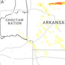
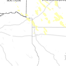
Hail Map for Sunday, June 25, 2023

Number of Impacted Households on 6/25/2023
0
Impacted by 1" or Larger Hail
0
Impacted by 1.75" or Larger Hail
0
Impacted by 2.5" or Larger Hail
Square Miles of Populated Area Impacted on 6/25/2023
0
Impacted by 1" or Larger Hail
0
Impacted by 1.75" or Larger Hail
0
Impacted by 2.5" or Larger Hail


Cities Most Affected by Hail Storms of 6/25/2023
| Hail Size | Demographics of Zip Codes Affected | ||||||
|---|---|---|---|---|---|---|---|
| City | Count | Average | Largest | Pop Density | House Value | Income | Age |
| Marshall, AR | 4 | 2.81 | 4.50 | 13 | $48k | $22.0k | 45.8 |
| Kirklin, IN | 4 | 2.69 | 4.00 | 31 | $80k | $40.2k | 38.7 |
| Knox, IN | 5 | 2.05 | 3.00 | 105 | $80k | $37.0k | 39.5 |
| Ellettsville, IN | 3 | 1.83 | 2.00 | 293 | $89k | $43.4k | 37.1 |
| West Baden Springs, IN | 2 | 2.75 | 3.00 | 27 | $60k | $34.5k | 41.6 |
| Richmond, KY | 2 | 2.63 | 2.75 | 202 | $99k | $32.4k | 32.5 |
| Sheridan, IN | 2 | 2.50 | 2.50 | 77 | $111k | $50.4k | 39.6 |
| Mountain View, AR | 2 | 2.38 | 3.00 | 20 | $69k | $21.5k | 48.8 |
| Clay, KY | 2 | 2.38 | 2.50 | 26 | $47k | $32.9k | 40.2 |
| French Lick, IN | 2 | 2.38 | 2.75 | 56 | $69k | $33.3k | 41.8 |
| Carbon Hill, AL | 2 | 2.00 | 2.00 | 26 | $56k | $23.6k | 42.1 |
| Timbo, AR | 1 | 3.00 | 3.00 | 19 | $52k | $23.1k | 45.7 |
| Atkins, AR | 1 | 3.00 | 3.00 | 54 | $56k | $27.3k | 39.6 |
| Loogootee, IN | 1 | 3.00 | 3.00 | 59 | $73k | $39.0k | 37.2 |
| Spencer, IN | 1 | 2.75 | 2.75 | 76 | $90k | $37.4k | 42.4 |
| Plymouth, IN | 1 | 2.75 | 2.75 | 153 | $89k | $41.9k | 38.6 |
| Bloomington, IN | 1 | 2.50 | 2.50 | 434 | $100k | $31.1k | 30.4 |
| Ozone, AR | 1 | 2.50 | 2.50 | 4 | $46k | $26.6k | 48.0 |
| Carthage, TN | 1 | 2.00 | 2.00 | 112 | $89k | $30.6k | 41.1 |
| Owensboro, KY | 1 | 2.00 | 2.00 | 250 | $80k | $34.7k | 38.7 |
| Ramsey, IN | 1 | 2.00 | 2.00 | 106 | $88k | $49.9k | 39.2 |
| Madisonville, KY | 1 | 1.75 | 1.75 | 161 | $63k | $32.1k | 40.2 |
| Lawrenceburg, TN | 1 | 1.75 | 1.75 | 83 | $75k | $30.7k | 41.0 |
| Chattanooga, TN | 1 | 1.75 | 1.75 | 2076 | $73k | $33.8k | 38.8 |
| Princeton, IN | 1 | 1.75 | 1.75 | 155 | $67k | $33.7k | 39.2 |
| Somerville, AL | 1 | 1.75 | 1.75 | 76 | $90k | $38.7k | 41.9 |
| Jasper, IN | 1 | 1.75 | 1.75 | 171 | $101k | $46.9k | 40.4 |
| Russellville, AR | 1 | 1.75 | 1.75 | 161 | $83k | $38.7k | 38.0 |
| Madison, IN | 1 | 1.75 | 1.75 | 105 | $89k | $37.7k | 41.1 |
| Battletown, KY | 1 | 1.75 | 1.75 | 19 | $51k | $33.1k | 40.2 |
| Madison, AL | 1 | 1.75 | 1.75 | 162 | $85k | $41.2k | 36.1 |
| Oakland City, IN | 1 | 1.75 | 1.75 | 54 | $65k | $32.0k | 40.4 |
Hail and Wind Damage Spotted on 6/25/2023
Filter by Report Type:Hail ReportsWind Reports
States Impacted
Kentucky, Tennessee, Indiana, New Jersey, Alabama, Michigan, Maryland, Georgia, Pennsylvania, Arkansas, Ohio, South Carolina, Virginia, Idaho, Mississippi, Texas, Florida, South DakotaKentucky
| Local Time | Report Details |
|---|---|
| 9:00 AM CDT | Tree down over davis bend roa in hart county KY, 47.4 miles S of Louisville, KY |
| 9:07 AM CDT | Tree down over hwy 729 in southern green count in green county KY, 58.8 miles S of Louisville, KY |
| 10:50 AM EDT | Video shows scattered tree damage around a house in hodgenvill in larue county KY, 28.8 miles S of Louisville, KY |
| 4:13 PM CDT | Half Dollar sized hail reported near Sturgis, KY, 37.2 miles SW of Evansville, IN |
| 4:17 PM CDT | Half Dollar sized hail reported near Sturgis, KY, 38.8 miles SSW of Evansville, IN |
| 4:24 PM CDT | Tennis Ball sized hail reported near Clay, KY, 37 miles SSW of Evansville, IN |
| 4:24 PM CDT | Hen Egg sized hail reported near Clay, KY, 37 miles SSW of Evansville, IN |
| 4:26 PM CDT | Ping Pong Ball sized hail reported near Wheatcroft, KY, 37.3 miles SSW of Evansville, IN |
| 4:54 PM CDT | Half Dollar sized hail reported near Calhoun, KY, 34.4 miles SSE of Evansville, IN |
| 5:00 PM CDT | Golf Ball sized hail reported near Madisonville, KY, 44 miles S of Evansville, IN, hail ranging from quarter to golf ball sized. |
| 6:23 PM EDT | Quarter sized hail reported near Louisville, KY, 16.8 miles N of Louisville, KY, video of quarter sized hail. |
| 6:36 PM EDT | Quarter sized hail reported near Louisville, KY, 7.5 miles NNE of Louisville, KY |
| 6:46 PM EDT | Quarter sized hail reported near Louisville, KY, 15.5 miles N of Louisville, KY |
| 6:50 PM EDT | Half Dollar sized hail reported near Louisville, KY, 15.5 miles NNW of Louisville, KY |
| 6:52 PM EDT | Ping Pong Ball sized hail reported near Louisville, KY, 13.4 miles NNW of Louisville, KY |
| 7:09 PM EDT | Tree down on cedar grove road in bullitt count in bullitt county KY, 0.7 miles SE of Louisville, KY |
| 7:19 PM EDT | Quarter sized hail reported near Mount Washington, KY, 7.8 miles ENE of Louisville, KY |
| 7:23 PM EDT | Tree down on jonesville road. time estimated from rada in owen county KY, 36.1 miles SSW of Cincinnati, OH |
| 7:30 PM EDT | Quarter sized hail reported near Mount Washington, KY, 10.6 miles ENE of Louisville, KY |
| 8:26 PM EDT | Trees dow in jefferson county KY, 20.6 miles NNE of Louisville, KY |
| 8:30 PM EDT | Large limbs down and power outages between lyndon and middletow in jefferson county KY, 19.8 miles NNE of Louisville, KY |
| 8:35 PM EDT | Quarter sized hail reported near La Grange, KY, 30.3 miles NNE of Louisville, KY |
| 9:01 PM EDT | Trees dow in shelby county KY, 24.7 miles ENE of Louisville, KY |
| 9:06 PM EDT | Quarter sized hail reported near Louisville, KY, 17.5 miles NNE of Louisville, KY |
| 9:08 PM EDT | Quarter sized hail reported near Frankfort, KY, 39.4 miles ENE of Louisville, KY |
| 9:10 PM EDT | Quarter sized hail reported near Louisville, KY, 13.5 miles NNE of Louisville, KY |
| 9:11 PM EDT | 1 inch hail as wel in jefferson county KY, 10.5 miles NNE of Louisville, KY |
| 9:12 PM EDT | Quarter sized hail reported near Louisville, KY, 12.7 miles NE of Louisville, KY |
| 9:14 PM EDT | Ping Pong Ball sized hail reported near Lawrenceburg, KY, 38.2 miles ENE of Louisville, KY, quarter to ping pong ball size hail reported. |
| 9:17 PM EDT | Golf Ball sized hail reported near Battletown, KY, 35.7 miles WNW of Louisville, KY |
| 9:20 PM EDT | Quarter sized hail reported near Mount Washington, KY, 12.3 miles ENE of Louisville, KY |
| 9:26 PM EDT | Quarter sized hail reported near Taylorsville, KY, 20.4 miles ENE of Louisville, KY |
| 8:33 PM CDT | Quarter sized hail reported near Irvington, KY, 35.9 miles W of Louisville, KY |
| 8:40 PM CDT | Ping Pong Ball sized hail reported near Owensboro, KY, 25.3 miles SE of Evansville, IN, half dollar to ping pong sized hail near sorgho elementary school west of owensboro. |
| 8:43 PM CDT | Trees on ca in breckinridge county KY, 31.9 miles W of Louisville, KY |
| 8:45 PM CDT | Hen Egg sized hail reported near Owensboro, KY, 27 miles SE of Evansville, IN, 2 inch diameter hail at owensboro airport. |
| 8:45 PM CDT | Half Dollar sized hail reported near Clinton, KY, 45.4 miles NW of Mc Kenzie, TN |
| 8:51 PM CDT | Ky 307 blocked south of ky-58 due to numerous trees dow in hickman county KY, 40.7 miles NNW of Mc Kenzie, TN |
| 9:55 PM EDT | Trees down on clifton rd and tyrone pik in woodford county KY, 48.3 miles WNW of Irvine, KY |
| 8:56 PM CDT | Numerous trees down from stanley to owensboro and across much of the rest of the county. very large hail... at least 2 inches in diameter reported in several areas. fir in daviess county KY, 29 miles ESE of Evansville, IN |
| 9:00 PM CDT | Tree down across county road 129... about 3/4 mile south of hwy 339 near wingo. multiple trees and power poles snapped in the wingo are in graves county KY, 36.9 miles NNW of Mc Kenzie, TN |
| 10:05 PM EDT | Downed tree blocking cornishville roa in mercer county KY, 45.1 miles ESE of Louisville, KY |
| 9:10 PM CDT | Trees down on dr melvin rd off of ky 9 in graves county KY, 33.7 miles N of Mc Kenzie, TN |
| 10:12 PM EDT | Reports of several trees dow in jessamine county KY, 39.1 miles WNW of Irvine, KY |
| 10:15 PM EDT | Quarter sized hail reported near Nicholasville, KY, 34.5 miles WNW of Irvine, KY |
| 9:20 PM CDT | Tree blocking swan roa in calloway county KY, 30.2 miles N of Mc Kenzie, TN |
| 9:20 PM CDT | Storm damage reported in calloway county KY, 33.3 miles NNE of Mc Kenzie, TN |
| 10:44 PM EDT | Baseball sized hail reported near Richmond, KY, 27 miles WNW of Irvine, KY |
| 10:45 PM EDT | Ping Pong Ball sized hail reported near Richmond, KY, 18.2 miles W of Irvine, KY |
| 10:46 PM EDT | Tennis Ball sized hail reported near Richmond, KY, 19.5 miles WNW of Irvine, KY |
| 10:47 PM EDT | Trees down across the road in bryantsvill in garrard county KY, 37 miles W of Irvine, KY |
| 10:50 PM EDT | Corrects previous tstm wnd dmg report from hodgenville. video shows scattered tree damage around a house in hodgenvill in larue county KY, 28.8 miles S of Louisville, KY |
| 10:52 PM EDT | Quarter sized hail reported near Richmond, KY, 13.2 miles WNW of Irvine, KY |
| 10:52 PM EDT | Storm damage reported in madison county KY, 18.2 miles W of Irvine, KY |
| 10:57 PM EDT | Downed tree and power lines between church and center street in nelson county KY, 27.1 miles SSE of Louisville, KY |
| 11:00 PM EDT | Kentucky mesonet station elst richmond 8 in madison county KY, 9.7 miles W of Irvine, KY |
| 11:05 PM EDT | Multiple trees were reported to have been down along ky 52 from winston west to the madison county lin in estill county KY, 5.2 miles W of Irvine, KY |
| 11:11 PM EDT | A tree was blown down near the stacy lane apartments on stacy lane roa in estill county KY, 2.8 miles WSW of Irvine, KY |
| 11:15 PM EDT | Trees were reported to have been blown down onto utility lines on upper dry fork near sandgap. the even time is radar estimate in jackson county KY, 15.8 miles SSW of Irvine, KY |
| 10:17 PM CDT | Report per clarkson fire chief... a 20x50 pole barn has been destroyed by strong winds just a mile north of clarkson city limits. grayson count in grayson county KY, 43 miles SW of Louisville, KY |
| 10:19 PM CDT | Quarter sized hail reported near Webster, KY, 35 miles W of Louisville, KY |
| 10:20 PM CDT | Half Dollar sized hail reported near Caneyville, KY, 62.7 miles SW of Louisville, KY |
| 10:26 PM CDT | Numerous trees down across the roadways in several areas including priceville... linwood... munfordville... and hardyville. several power outages also being reported ac in hart county KY, 49.8 miles SSW of Louisville, KY |
| 10:27 PM CDT | Quarter sized hail reported near Caneyville, KY, 57.2 miles SW of Louisville, KY |
| 11:28 PM EDT | Multiple trees were reported to have been blown down on spencer ridge road. the even time is radar estimate in lee county KY, 14.1 miles SE of Irvine, KY |
| 11:30 PM EDT | A tree was reported to have been blown down along wilderness road near the intersection with flat gap road. the event time is radar estimate in rockcastle county KY, 22.6 miles WSW of Irvine, KY |
| 11:36 PM EDT | A tree was reported to have been blown down onto a house in beattyville. the event time is radar estimate in lee county KY, 17.1 miles ESE of Irvine, KY |
| 11:38 PM EDT | Several trees were blown down on pine grove road in southern lee county near owsley count in lee county KY, 18.7 miles SE of Irvine, KY |
| 11:45 PM EDT | Tree limbs and other debris across us 27 near dix river golf cours in lincoln county KY, 37.2 miles WSW of Irvine, KY |
| 11:53 PM EDT | Tree down across the roa in garrard county KY, 37 miles W of Irvine, KY |
| 11:54 PM EDT | Storm damage reported in garrard county KY, 37 miles W of Irvine, KY |
| 11:55 PM EDT | A tree was reported to have been blown down onto ky 11 near the owsley county lin in clay county KY, 29.6 miles SSE of Irvine, KY |
| 12:06 AM EDT | A tree was reported to have been blown down litton town road. the even time is radar estimate in laurel county KY, 36.1 miles SSW of Irvine, KY |
| 12:10 AM EDT | Two trees were reported to have been blown down near the mouth of bowling creek. the event time is radar estimate in breathitt county KY, 35 miles SE of Irvine, KY |
| 11:10 PM CDT | Corrects previous tstm wnd dmg report from 1 wnw columbia. reports of trees down across roadway and one has fallen on a vehicle causing damag in adair county KY, 65 miles SSE of Louisville, KY |
| 11:10 PM CDT | Corrects previous tstm wnd dmg report from 1 wnw columbia. reports of trees down across roadway and one has fallen on a vehicle causing damag in adair county KY, 65 miles SSE of Louisville, KY |
| 11:15 PM CDT | Tree down south 55 blocking roadwa in adair county KY, 70.9 miles SSE of Louisville, KY |
| 11:19 PM CDT | Significant damage to boat storage building at jamestown marina. numerous trees and power lines dow in russell county KY, 79.5 miles SW of Irvine, KY |
| 11:20 PM CDT | Numerous trees and power lines down across barren count in barren county KY, 69 miles S of Louisville, KY |
| 11:20 PM CDT | Kentucky mesonet station wdby morgantown 4 ss in butler county KY, 70.2 miles N of Nashville, TN |
| 11:25 PM CDT | Trees down holmes bend road near lake and campgroun in adair county KY, 58.3 miles SSE of Louisville, KY |
| 12:27 AM EDT | A tree was reported to have been blown down on pine top roa in laurel county KY, 41.1 miles SSW of Irvine, KY |
| 12:30 AM EDT | Trees were reported to have been blown down in the bugwood communit in wayne county KY, 79.9 miles SW of Irvine, KY |
| 12:31 AM EDT | Measured by kekq awo in wayne county KY, 75.7 miles SW of Irvine, KY |
| 11:35 PM CDT | Kentucky mesonet site ewpk measured a 63 mph wind gus in warren county KY, 64.7 miles NNE of Nashville, TN |
| 12:43 AM EDT | Trees were reported to have been blown down on ky 92 east. the event time is radar estimate in wayne county KY, 74.3 miles NW of Knoxville, TN |
| 11:47 PM CDT | Trees were blown down across cumberland county... resulting in several road closure in cumberland county KY, 84.8 miles SSE of Louisville, KY |
| 1:00 AM EDT | A tree was reported to have been blown down on us 27. the even time is radar estimate in mccreary county KY, 61.3 miles NNW of Knoxville, TN |
| 12:00 AM CDT | Numerous reports of tree and power line damage across clinton count in clinton county KY, 84.6 miles NW of Knoxville, TN |
| 1:05 AM EDT | Trees were reported to have been blown down on cumberland falls highway near the intersection with ky 90. the even time is radar estimate in whitley county KY, 59.6 miles SSW of Irvine, KY |
Tennessee
| Local Time | Report Details |
|---|---|
| 1:37 PM EDT | Several trees down across the count in roane county TN, 28.2 miles W of Knoxville, TN |
| 12:47 PM CDT | Golf Ball sized hail reported near Lawrenceburg, TN, 39.3 miles NE of Florence, AL |
| 1:48 PM EDT | Several trees dow in knox county TN, 17.1 miles WSW of Knoxville, TN |
| 2:03 PM EDT | Numerous trees down across loudon count in loudon county TN, 25.7 miles WSW of Knoxville, TN |
| 1:03 PM CDT | Hen Egg sized hail reported near Carthage, TN, 47.5 miles E of Nashville, TN |
| 1:05 PM CDT | A few trees dow in bledsoe county TN, 48.7 miles NNE of Chattanooga, TN |
| 2:22 PM EDT | Numerous trees down across the southern end of blount count in blount county TN, 20.3 miles SW of Knoxville, TN |
| 2:45 PM EDT | Several trees dow in rhea county TN, 47.7 miles NNE of Chattanooga, TN |
| 1:45 PM CDT | Several trees dow in bledsoe county TN, 40.9 miles N of Chattanooga, TN |
| 3:15 PM EDT | Several trees dow in mcminn county TN, 42.2 miles NE of Chattanooga, TN |
| 2:36 PM CDT | Report of 6-8 trees down 18-24 inches in diameter in lynchburg. time estimated by rada in moore county TN, 63 miles SSE of Nashville, TN |
| 2:40 PM CDT | A few trees dow in marion county TN, 26.9 miles WNW of Chattanooga, TN |
| 3:42 PM EDT | Several trees down across the count in polk county TN, 40.8 miles E of Chattanooga, TN |
| 3:03 PM CDT | Several trees dow in marion county TN, 24.7 miles W of Chattanooga, TN |
| 3:15 PM CDT | Few trees dow in sequatchie county TN, 21.5 miles NNW of Chattanooga, TN |
| 3:25 PM CDT | Several reports of trees down across marion count in marion county TN, 9.1 miles W of Chattanooga, TN |
| 4:25 PM EDT | Golf Ball sized hail reported near Chattanooga, TN, 4.7 miles ESE of Chattanooga, TN, picture of golfball size hail in east ridge tn. |
| 4:30 PM EDT | Quarter sized hail reported near Chattanooga, TN, 3.8 miles ESE of Chattanooga, TN, quarter size hail in east ridge tn. |
| 6:35 PM CDT | Corrects previous tstm wnd dmg report from bartlett. split trees... branches everywher in shelby county TN, 12.8 miles ENE of Memphis, TN |
| 6:36 PM CDT | Several trees down near navy road and highway 5 in shelby county TN, 15.3 miles NNE of Memphis, TN |
| 6:37 PM CDT | Widespread tree and powerline damage in millington. trees down on homes and vehicles... and some utility poles were snapped. some structures sustained damage... includi in shelby county TN, 15.9 miles NE of Memphis, TN |
| 6:45 PM CDT | Corrects previous tstm wnd dmg report from bartlett. corrects previous tstm wnd dmg report from bartlett. split trees... branches everywher in shelby county TN, 12.8 miles ENE of Memphis, TN |
| 6:53 PM CDT | Numerous trees down... uprooted... snapped. part of roof blown off gas station and dental building near i-40... exit 2 in shelby county TN, 18.1 miles ENE of Memphis, TN |
| 6:55 PM CDT | Corrects previous tstm wnd gst report from bartlett. 70 mph wind gust recorded in bartlet in shelby county TN, 15.2 miles ENE of Memphis, TN |
| 6:58 PM CDT | 60 mph wind gus in shelby county TN, 14.1 miles ENE of Memphis, TN |
| 6:59 PM CDT | 60-70 mph sind gusts. possilbel trees down as wel in shelby county TN, 12.8 miles ENE of Memphis, TN |
| 7:00 PM CDT | Six utility poles were snapped along us 64 between kate bond road and north germantown parkway. widespread tree damage in the area with power out to most of bartlet in shelby county TN, 14.5 miles ENE of Memphis, TN |
| 7:00 PM CDT | Corrects previous tstm wnd dmg report from bartlett. numerous trees down across north bartlet in shelby county TN, 12.8 miles ENE of Memphis, TN |
| 7:02 PM CDT | Trees down near the intersection of highway 196 and orr road in hickory with in fayette county TN, 26.6 miles ENE of Memphis, TN |
| 7:03 PM CDT | 70 mph wind gust recorded in bartlet in shelby county TN, 12.8 miles ENE of Memphis, TN |
| 7:08 PM CDT | Spotter reports numerous trees down on i-40 near mile marker 20. tree on ca in shelby county TN, 18.9 miles ENE of Memphis, TN |
| 7:12 PM CDT | Report from mping: trees uprooted or snapped; roof blown of in shelby county TN, 18.1 miles ENE of Memphis, TN |
| 7:19 PM CDT | Numerous trees down across north bartlet in shelby county TN, 12.8 miles ENE of Memphis, TN |
| 7:25 PM CDT | Corrects previous tstm wnd dmg report from 4 nnw moscow. report from mping: trees uprooted or snappe in fayette county TN, 35.7 miles E of Memphis, TN |
| 7:35 PM CDT | Split trees... branches everywher in shelby county TN, 12.8 miles ENE of Memphis, TN |
| 7:42 PM CDT | Report from mping: trees uprooted or snapped; roof blown of in fayette county TN, 35.7 miles E of Memphis, TN |
| 7:52 PM CDT | Trees and powerlines down on c allen lan in hardeman county TN, 63.1 miles E of Memphis, TN |
| 8:08 PM CDT | Dime sized hail and 60 mph wind in chester county TN, 53 miles SSW of Mc Kenzie, TN |
| 8:15 PM CDT | Quarter sized hail reported near Henderson, TN, 45.9 miles S of Mc Kenzie, TN |
| 1:05 AM EDT | A few trees dow in scott county TN, 54.8 miles NW of Knoxville, TN |
| 1:40 AM EDT | A few trees dow in scott county TN, 46.3 miles NW of Knoxville, TN |
| 1:45 AM EDT | Several trees dow in claiborne county TN, 38.7 miles NNE of Knoxville, TN |
| 1:50 AM EDT | Few trees dow in claiborne county TN, 38.6 miles N of Knoxville, TN |
| 1:57 AM EDT | Several trees dow in campbell county TN, 30.8 miles NNW of Knoxville, TN |
| 2:17 AM EDT | Trees and power lines down across parts of the count in claiborne county TN, 34.5 miles NNE of Knoxville, TN |
| 2:47 AM EDT | A few trees dow in jefferson county TN, 24.5 miles ENE of Knoxville, TN |
| 3:06 AM EDT | Large tree limbs down on car. limbs estimated to be 10 to 12 inches in diameter based on picture from social media. time estimate based on radar dat in cocke county TN, 44.5 miles ESE of Knoxville, TN |
Indiana
| Local Time | Report Details |
|---|---|
| 12:56 PM CDT | Gust to 52 knots at michigan city glerl sit in lmz745 county IN, 37.8 miles ESE of Chicago, IL |
| 1:05 PM CDT | Ping Pong Ball sized hail reported near La Crosse, IN, 54.7 miles SE of Chicago, IL, trained spotter reports hail 1 to 1.5 inches in diameter in la crosse... in. |
| 1:08 PM CDT | Quarter sized hail reported near La Crosse, IN, 54.7 miles SE of Chicago, IL, public report on facebook of nickel to quarter size hail near la crosse... in. time estimated from radar. |
| 1:12 PM CDT | Ping Pong Ball sized hail reported near La Crosse, IN, 54.7 miles SE of Chicago, IL |
| 1:34 PM CDT | Hen Egg sized hail reported near Knox, IN, 67 miles SE of Chicago, IL, reported by not trained spotter. |
| 1:35 PM CDT | Golf Ball sized hail reported near Knox, IN, 67.4 miles SE of Chicago, IL |
| 1:36 PM CDT | Quarter sized hail reported near Knox, IN, 64.7 miles SE of Chicago, IL |
| 2:36 PM EDT | Time and location are estimated - numerous tree limbs dow in tippecanoe county IN, 46.5 miles NW of Indianapolis, IN |
| 1:36 PM CDT | Ping Pong Ball sized hail reported near Knox, IN, 66.6 miles SE of Chicago, IL |
| 1:40 PM CDT | Tea Cup sized hail reported near Knox, IN, 66.6 miles SE of Chicago, IL, multiple pictures on facebook of 2 inch hailstones and one 3 inch hailstone that fell in knox... in around 1:40 pm ct. |
| 1:42 PM CDT | Golf Ball sized hail reported near Knox, IN, 66.6 miles SE of Chicago, IL, broadcast media report of golf ball size hail in knox... in. time estimated from radar. |
| 1:45 PM CDT | Quarter sized hail reported near Knox, IN, 66.6 miles SE of Chicago, IL, trained spotter reports quarter size hail in knox... in. |
| 1:47 PM CDT | Golf Ball sized hail reported near Knox, IN, 68.2 miles SE of Chicago, IL |
| 2:54 PM EDT | Quarter sized hail reported near Royal Center, IN, 74.6 miles W of Fort Wayne, IN |
| 3:06 PM EDT | Baseball sized hail reported near Plymouth, IN, 65.9 miles WNW of Fort Wayne, IN, photos on twitter of baseball size hailstones in plymouth. time estimated from radar. |
| 3:10 PM EDT | Quarter sized hail reported near Plymouth, IN, 70 miles WNW of Fort Wayne, IN, report from mping: quarter (1.00 in.). |
| 3:12 PM EDT | Public report on twitter of quarter size hail in bremen. time estimated from rada in marshall county IN, 61 miles WNW of Fort Wayne, IN |
| 3:14 PM EDT | Quarter sized hail reported near Argos, IN, 60.6 miles W of Fort Wayne, IN |
| 3:14 PM EDT | Report from mping: 1-inch tree limbs broken; shingles blown of in marshall county IN, 59.1 miles WNW of Fort Wayne, IN |
| 3:15 PM EDT | Storm damage reported in fulton county IN, 61.2 miles W of Fort Wayne, IN |
| 3:17 PM EDT | Quarter sized hail reported near Argos, IN, 60.6 miles W of Fort Wayne, IN, report from mping: quarter (1.00 in.). |
| 3:18 PM EDT | Baseball sized hail reported near Kirklin, IN, 31.2 miles NNW of Indianapolis, IN, damage to roof and siding of home. |
| 3:18 PM EDT | Grapefruit sized hail reported near Kirklin, IN, 31.2 miles NNW of Indianapolis, IN, size estimated from references used in social media photos. |
| 3:24 PM EDT | Large tree down... powerlines down... and 1 to 3 inch tree limbs snapped near twin lakes... in. near the intersection of 13th road and south rose road. time estimated b in marshall county IN, 67.5 miles WNW of Fort Wayne, IN |
| 3:25 PM EDT | Ping Pong Ball sized hail reported near Frankfort, IN, 36.7 miles NW of Indianapolis, IN, picture of ping-pong ball sized hail e of colfax. time estimated to be 3:25 pm. |
| 3:25 PM EDT | Hen Egg sized hail reported near Kirklin, IN, 33.1 miles NNW of Indianapolis, IN, picture of pool-ball sized hail submitted on social media by member of public. |
| 3:30 PM EDT | Quarter sized hail reported near Akron, IN, 48.2 miles W of Fort Wayne, IN |
| 3:36 PM EDT | Broadcast media reports tree and powerlines down at the intersection of w main street and n dolan drive in syracuse... in. time estimated by rada in kosciusko county IN, 41.8 miles NW of Fort Wayne, IN |
| 3:40 PM EDT | Trained spotter reports tree snapped in half on their property. multiple large branches across pinkerton and price road in kosciusko county IN, 45.3 miles WNW of Fort Wayne, IN |
| 3:45 PM EDT | Hen Egg sized hail reported near Kirklin, IN, 32 miles NNW of Indianapolis, IN, public report of 2 inch hail in kirklin... in via social media. |
| 3:45 PM EDT | Quarter sized hail reported near Mentone, IN, 49.5 miles W of Fort Wayne, IN, public report on facebook of quarter size hail in mentone... in. time estimated by radar. |
| 3:45 PM EDT | Tennis Ball sized hail reported near Sheridan, IN, 28.2 miles N of Indianapolis, IN, report from mping: tennis ball (2.50 in.). |
| 3:47 PM EDT | Report from mping: 1-inch tree limbs broken; shingles blown of in boone county IN, 26.1 miles NNW of Indianapolis, IN |
| 3:47 PM EDT | Quarter sized hail reported near Plainfield, IN, 14.1 miles W of Indianapolis, IN, quarter sized hail reported by member of public in n plainfield. time estimated via radar. |
| 3:53 PM EDT | Quarter sized hail reported near Clayton, IN, 17.1 miles WSW of Indianapolis, IN, report from mping: quarter (1.00 in.). |
| 3:54 PM EDT | Half Dollar sized hail reported near Plainfield, IN, 15.6 miles WSW of Indianapolis, IN, report from mping: half dollar (1.25 in.). |
| 3:55 PM EDT | Tennis Ball sized hail reported near Sheridan, IN, 25.3 miles N of Indianapolis, IN, report from mping: tennis ball (2.50 in.). |
| 3:56 PM EDT | Quarter sized hail reported near Washington, IN, 52 miles NNE of Evansville, IN, the hail lasted about 5 min. |
| 3:57 PM EDT | Several 1 ft diameter tree limbs downed. appear healthy from photo in noble county IN, 32.7 miles NNW of Fort Wayne, IN |
| 3:59 PM EDT | Half Dollar sized hail reported near Gosport, IN, 39.6 miles SW of Indianapolis, IN, report from mping: half dollar (1.25 in.). |
| 4:00 PM EDT | Multiple trees with snapped limbs 6 to 12 inches in diameter in rome city. photos from twitter. time estimated from rada in lagrange county IN, 41 miles N of Fort Wayne, IN |
| 4:00 PM EDT | Emergency manager reports tree down onto vehicle in larwill. no known injuries. time estimated from rada in whitley county IN, 28.1 miles WNW of Fort Wayne, IN |
| 4:00 PM EDT | Public report of tree damage... blocking speedway drive. time estimated via rada in marion county IN, 6.3 miles WNW of Indianapolis, IN |
| 4:03 PM EDT | Powerlines down in larwill. time estimated by rada in whitley county IN, 28.1 miles WNW of Fort Wayne, IN |
| 4:05 PM EDT | Baseball sized hail reported near Spencer, IN, 46.7 miles SW of Indianapolis, IN |
| 4:05 PM EDT | Quarter sized hail reported near Cicero, IN, 26.1 miles NNE of Indianapolis, IN, report from mping: quarter (1.00 in.). |
| 4:06 PM EDT | Pictures of tree damage just off i-69 at the loogootee exit. delayed report... time estimated via rada in daviess county IN, 53.2 miles NNE of Evansville, IN |
| 4:08 PM EDT | Quarter sized hail reported near Washington, IN, 52.4 miles NNE of Evansville, IN, report from mping: quarter (1.00 in.). |
| 4:10 PM EDT | Golf Ball sized hail reported near Ellettsville, IN, 43.9 miles SW of Indianapolis, IN, multiple delayed reports via social media of measured 1.75 inch hail in ellettsville. time estimated via radar. |
| 4:12 PM EDT | Quarter sized hail reported near Akron, IN, 44.5 miles W of Fort Wayne, IN |
| 4:14 PM EDT | Quarter sized hail reported near Ellettsville, IN, 45.3 miles SSW of Indianapolis, IN, report from mping: quarter (1.00 in.). |
| 4:15 PM EDT | Multiple public reports of damage to structures and heavily damaged roofs off stones crossing road in the kensington grove neighborhood. time estimated via radar. *tor in johnson county IN, 14 miles SSW of Indianapolis, IN |
| 4:15 PM EDT | Tennis Ball sized hail reported near Bloomington, IN, 46.5 miles SSW of Indianapolis, IN |
| 4:15 PM EDT | Hen Egg sized hail reported near Ellettsville, IN, 44.5 miles SSW of Indianapolis, IN |
| 4:15 PM EDT | Photos of trees down and roof damage to homes in neighborhood south of center grove hs near intersection of morgantown and travis rds. time estimated via radar. *tor po in johnson county IN, 13.8 miles S of Indianapolis, IN |
| 4:15 PM EDT | Delayed report via social media. damage reported to homes in the waters edge subdivision. time estimated via radar. *tor possible in johnson county IN, 13.8 miles S of Indianapolis, IN |
| 4:16 PM EDT | Quarter sized hail reported near Gosport, IN, 36.1 miles SW of Indianapolis, IN |
| 4:16 PM EDT | Golf Ball sized hail reported near Ellettsville, IN, 45.3 miles SSW of Indianapolis, IN, report from mping: golf ball (1.75 in.). |
| 4:16 PM EDT | Quarter sized hail reported near Bloomington, IN, 46.7 miles SSW of Indianapolis, IN |
| 4:18 PM EDT | Half Dollar sized hail reported near Bloomington, IN, 45 miles SSW of Indianapolis, IN, report from mping: half dollar (1.25 in.). |
| 4:18 PM EDT | Quarter sized hail reported near North Manchester, IN, 35.3 miles W of Fort Wayne, IN, photos on twitter show estimated quarter size hail in north manchester... in. time estimated by radar. |
| 4:20 PM EDT | Ping Pong Ball sized hail reported near Greenwood, IN, 12.3 miles S of Indianapolis, IN, time estimated from radar. |
| 4:22 PM EDT | Half Dollar sized hail reported near Greenwood, IN, 11.8 miles SSE of Indianapolis, IN, report from mping: half dollar (1.25 in.). |
| 4:23 PM EDT | Quarter sized hail reported near Columbia City, IN, 20.7 miles WNW of Fort Wayne, IN |
| 4:25 PM EDT | Salem township fire department has wind damage to their building including a portion of the roof missing and damage to a wall. reported by steuben county emergency mana in steuben county IN, 33.6 miles N of Fort Wayne, IN |
| 4:25 PM EDT | Ema volunteer reports structural damage to a large barn and a small outbuilding destroyed by strong winds. time estimated from rada in steuben county IN, 34.2 miles N of Fort Wayne, IN |
| 4:25 PM EDT | Emergency manager reports damage to a barn. part of barn roof in the roadway at cr 950 e and cr 100 n. time estimated from rada in steuben county IN, 43 miles NNE of Fort Wayne, IN |
| 4:25 PM EDT | Tea Cup sized hail reported near Loogootee, IN, 59.8 miles NE of Evansville, IN, 3 inch measured hailstone. delayed report. |
| 4:27 PM EDT | Ping Pong Ball sized hail reported near Loogootee, IN, 59.2 miles NE of Evansville, IN, delayed public report of hail in between quarter and golf ball size in loogootee via social media. time estimated via radar. |
| 4:27 PM EDT | Ping Pong Ball sized hail reported near Indianapolis, IN, 6.6 miles SSE of Indianapolis, IN |
| 4:30 PM EDT | Quarter sized hail reported near North Manchester, IN, 35.4 miles W of Fort Wayne, IN, corrects previous hail report from north manchester. corrected time of occurrence. |
| 4:30 PM EDT | Powerlines down in northeast hamilton... in. time estimated from rada in steuben county IN, 33.5 miles NNE of Fort Wayne, IN |
| 4:30 PM EDT | Tornado possibl in daviess county IN, 71.4 miles NNE of Evansville, IN |
| 4:30 PM EDT | Damage at a car dealership at 1006 south wayne street in angola... in. damage to vehicles and structures. reported by angola fd... relayed by emergency manager. time es in steuben county IN, 38.6 miles N of Fort Wayne, IN |
| 4:31 PM EDT | Quarter sized hail reported near Indianapolis, IN, 12.5 miles SE of Indianapolis, IN, report from mping: quarter (1.00 in.). |
| 4:35 PM EDT | 10 inch diameter tree branches down in angol in steuben county IN, 39.3 miles N of Fort Wayne, IN |
| 4:35 PM EDT | Reports of multiple trees down on homes and cars. no reports of injuries at this tim in daviess county IN, 71.4 miles NNE of Evansville, IN |
| 4:38 PM EDT | Storm damage reported in steuben county IN, 34.9 miles NNE of Fort Wayne, IN |
| 4:44 PM EDT | Kenny park. 18 inch diameter tree snapped... appears healthy. several limbs downe in noble county IN, 37.2 miles NW of Fort Wayne, IN |
| 4:50 PM EDT | Half Dollar sized hail reported near Daleville, IN, 39.7 miles NE of Indianapolis, IN |
| 3:52 PM CDT | Golf Ball sized hail reported near Princeton, IN, 21.6 miles N of Evansville, IN, hail ranged from quarters to golf ball sized. driving by the toyota plant south of princeton indiana. |
| 4:55 PM EDT | Quarter sized hail reported near French Lick, IN, 62.6 miles NW of Louisville, KY, at the french lick resort. |
| 4:55 PM EDT | Half Dollar sized hail reported near Columbus, IN, 48.1 miles S of Indianapolis, IN, time estimated from radar. |
| 4:56 PM EDT | Hen Egg sized hail reported near French Lick, IN, 62.6 miles NW of Louisville, KY, picture relayed from social media. |
| 4:56 PM EDT | Tea Cup sized hail reported near West Baden Springs, IN, 63.4 miles NW of Louisville, KY |
| 4:59 PM EDT | Quarter sized hail reported near North Manchester, IN, 35.4 miles W of Fort Wayne, IN |
| 5:00 PM EDT | Corrects event type for tstm wnd gst report from 2 s coesse. mesonet station pdu05 northeast purdue agricultural cente in whitley county IN, 15.9 miles W of Fort Wayne, IN |
| 5:01 PM EDT | 18 inch tree down on hatzel road in new haven... i in allen county IN, 3.6 miles E of Fort Wayne, IN |
| 5:01 PM EDT | Report of 3 inch tree limbs down at the intersection of newnum rd and st. joe rd. time estimated from rada in allen county IN, 6.8 miles NNE of Fort Wayne, IN |
| 4:05 PM CDT | Golf Ball sized hail reported near Oakland City, IN, 25.9 miles NNE of Evansville, IN, report relayed via facebook. |
| 4:05 PM CDT | Quarter sized hail reported near Oakland City, IN, 25.5 miles NNE of Evansville, IN, report from mping: quarter (1.00 in.). |
| 5:11 PM EDT | Report from mping: 1-inch tree limbs broken; shingles blown of in brown county IN, 48.1 miles S of Indianapolis, IN |
| 5:12 PM EDT | 3 to 6 inch tree limb down on sherman blvd. time estimated from rada in allen county IN, 3.6 miles NW of Fort Wayne, IN |
| 5:15 PM EDT | Quarter sized hail reported near Fort Wayne, IN, 10.5 miles W of Fort Wayne, IN, reported by trained spotter. dime to quarter sized hail for about 5 minutes. |
| 5:19 PM EDT | Half Dollar sized hail reported near Velpen, IN, 33 miles NE of Evansville, IN |
| 5:20 PM EDT | Ping Pong Ball sized hail reported near Velpen, IN, 33.4 miles NE of Evansville, IN |
| 5:22 PM EDT | Ping Pong Ball sized hail reported near Marengo, IN, 43 miles NW of Louisville, KY |
| 5:24 PM EDT | Baseball sized hail reported near French Lick, IN, 62.6 miles NW of Louisville, KY |
| 5:25 PM EDT | Public report of tree damage and barn doors blown in and of in jackson county IN, 55.8 miles S of Indianapolis, IN |
| 5:29 PM EDT | Quarter sized hail reported near Huntingburg, IN, 39.7 miles NE of Evansville, IN, quarter sized hail fell. |
| 5:29 PM EDT | Tennis Ball sized hail reported near West Baden Springs, IN, 61.4 miles NW of Louisville, KY, 2.5 inch hail fell at a storm spotter home. |
| 5:30 PM EDT | 2 trees down over clay street in huntingbur in dubois county IN, 40.2 miles NE of Evansville, IN |
| 5:35 PM EDT | Quarter sized hail reported near Orleans, IN, 58.2 miles NW of Louisville, KY |
| 5:37 PM EDT | Quarter sized hail reported near Seymour, IN, 58.1 miles SSE of Indianapolis, IN, report of quarter (1.00 in.) sized hail east of seymour. |
| 4:39 PM CDT | Quarter sized hail reported near Gentryville, IN, 28.1 miles ENE of Evansville, IN, report from mping: quarter (1.00 in.). |
| 5:41 PM EDT | Golf Ball sized hail reported near Jasper, IN, 43.9 miles NE of Evansville, IN, dubois county highway garage. |
| 5:45 PM EDT | Relayed report of possible damage in jennings county along cr 640 west near commiskey. barn roof blown off and trees uprooted. time estimated from rada in jennings county IN, 62.2 miles N of Louisville, KY |
| 5:49 PM EDT | Hen Egg sized hail reported near Ramsey, IN, 33.3 miles NW of Louisville, KY |
| 5:58 PM EDT | Quarter sized hail reported near Georgetown, IN, 26.2 miles NW of Louisville, KY |
| 6:15 PM EDT | Time estimated - significant wind damag in floyd county IN, 17.7 miles NNW of Louisville, KY |
| 6:18 PM EDT | Tree down on i-64 near exit 12 in floyd county IN, 21.6 miles NNW of Louisville, KY |
| 6:20 PM EDT | Picture of uprooted tree relayed on social medi in harrison county IN, 36.6 miles NW of Louisville, KY |
| 6:23 PM EDT | Ping Pong Ball sized hail reported near Madison, IN, 53.7 miles WSW of Cincinnati, OH |
| 6:25 PM EDT | Golf Ball sized hail reported near Madison, IN, 53.2 miles WSW of Cincinnati, OH |
| 6:26 PM EDT | Quarter sized hail reported near Madison, IN, 55 miles WSW of Cincinnati, OH |
| 6:36 PM EDT | Half Dollar sized hail reported near Georgetown, IN, 24.7 miles NNW of Louisville, KY |
| 7:04 PM EDT | Quarter sized hail reported near Sunman, IN, 32.8 miles WNW of Cincinnati, OH, mping report. |
| 7:11 PM EDT | Quarter sized hail reported near Lawrenceburg, IN, 22.6 miles WNW of Cincinnati, OH, mping report |
| 7:11 PM EDT | Quarter sized hail reported near Guilford, IN, 22.2 miles WNW of Cincinnati, OH |
| 7:45 PM EDT | Quarter sized hail reported near Orleans, IN, 58.2 miles NW of Louisville, KY |
| 8:14 PM EDT | Quarter sized hail reported near Charlestown, IN, 35.8 miles NNE of Louisville, KY, quarter sized hail in vesta. |
| 8:15 PM EDT | Firework tent damage and a tree fallen onto a power line near the white castl in clark county IN, 21.5 miles N of Louisville, KY |
| 8:34 PM EDT | Report from mping: 1-inch tree limbs broken; shingles blown of in allen county IN, 3.1 miles ENE of Fort Wayne, IN |
| 8:47 PM EDT | Ping Pong Ball sized hail reported near Leavenworth, IN, 38.5 miles WNW of Louisville, KY |
| 8:52 PM EDT | Half Dollar sized hail reported near Jeffersonville, IN, 20.2 miles N of Louisville, KY, multiple reports of 1 to 1.25 inch sized hail from social media. |
| 9:06 PM EDT | Half Dollar sized hail reported near Corydon, IN, 23.2 miles WNW of Louisville, KY |
| 8:25 PM CDT | Quarter sized hail reported near Richland, IN, 19.5 miles ESE of Evansville, IN, report of nickel to quarter sized hail in town of hatfield. |
New Jersey
| Local Time | Report Details |
|---|---|
| 2:15 PM EDT | Spotter reports fallen tree limbs brought down power lines over the rail bridge closest to the intersection of oak st and glen av in bergen county NJ, 21.5 miles NNW of Brooklyn, NY |
| 5:01 PM EDT | Trees down in oaklyn. time estimated via rada in camden county NJ, 79.4 miles SW of Brooklyn, NY |
| 5:03 PM EDT | Trees down in oaklyn on oakland avenue. time estimated via rada in camden county NJ, 79.4 miles SW of Brooklyn, NY |
| 5:05 PM EDT | Wires down on norris street in camden. time estimated via rada in camden county NJ, 78.8 miles SW of Brooklyn, NY |
| 5:17 PM EDT | Pictures of a large tree down off of state ave between stone rd and pierce ave in lindenwold. time estimated via rada in camden county NJ, 80.4 miles SW of Brooklyn, NY |
| 5:17 PM EDT | Trees down in clementon on lake avenue. time estimated via rada in camden county NJ, 80.8 miles SW of Brooklyn, NY |
| 5:18 PM EDT | Trees down on linden ave in lindenwold. time estimated via rada in camden county NJ, 80.1 miles SW of Brooklyn, NY |
| 5:19 PM EDT | Trees down on winding way in gibbsboro. time estimated via rada in camden county NJ, 78.4 miles SW of Brooklyn, NY |
| 5:38 PM EDT | Wires down on richards avenue in pine hill. time estimated via rada in camden county NJ, 81.9 miles SW of Brooklyn, NY |
| 6:40 PM EDT | Report of a tree down in green brook twp. time estimated via rada in somerset county NJ, 26 miles WSW of Brooklyn, NY |
| 6:51 PM EDT | Report of a tree down in long hill twp. time estimated via rada in morris county NJ, 25.2 miles W of Brooklyn, NY |
| 6:57 PM EDT | Report of a tree down in harding township. time estimated via rada in morris county NJ, 26 miles W of Brooklyn, NY |
Alabama
| Local Time | Report Details |
|---|---|
| 1:20 PM CDT | Ping Pong Ball sized hail reported near Athens, AL, 46.4 miles E of Florence, AL |
| 1:21 PM CDT | Ping Pong Ball sized hail reported near Harvest, AL, 48.1 miles E of Florence, AL, spotter reported 1.5 inch hail near east limestone and capshaw rd. |
| 1:26 PM CDT | Quarter sized hail reported near Madison, AL, 50 miles E of Florence, AL, report from mping: quarter (1.00 in.). |
| 1:29 PM CDT | Quarter sized hail reported near Madison, AL, 51 miles E of Florence, AL, report from mping: quarter (1.00 in.). |
| 1:31 PM CDT | Quarter sized hail reported near Harvest, AL, 50.4 miles E of Florence, AL, report of quarter-size hail near old railroad bed road and capshaw road. |
| 1:33 PM CDT | Quarter sized hail reported near Madison, AL, 51.7 miles E of Florence, AL, picture from social media of quarter size hail... occurred on balch rd. location and time estimated by radar. |
| 1:33 PM CDT | Quarter sized hail reported near Madison, AL, 50 miles E of Florence, AL, social media photo report of quarter size hail at burgreen road between highway 72 and browns ferry road. time estimated by radar. |
| 1:37 PM CDT | Half Dollar sized hail reported near Madison, AL, 50.6 miles E of Florence, AL, spotter reported half dollar size hail near county line road and browns ferry road. |
| 1:39 PM CDT | Ping Pong Ball sized hail reported near Madison, AL, 51 miles E of Florence, AL, report from mping: ping pong ball (1.50 in.). |
| 1:40 PM CDT | Half Dollar sized hail reported near Madison, AL, 52.1 miles E of Florence, AL, broadcast media report via picture on social media of quarter to half dollar size hail off of capshaw road. location estimated by radar. |
| 1:40 PM CDT | Ping Pong Ball sized hail reported near Madison, AL, 53.4 miles E of Florence, AL, spotter reported ping pong size hail along wall triana highway. location estimated by radar. |
| 1:42 PM CDT | Quarter sized hail reported near Madison, AL, 53.4 miles E of Florence, AL, report via social media photo of penny to quarter size hail near hughes rd and gillespie rd. |
| 1:43 PM CDT | Half Dollar sized hail reported near Madison, AL, 52.9 miles E of Florence, AL, report from mping: half dollar (1.25 in.). |
| 1:45 PM CDT | Quarter sized hail reported near Madison, AL, 52.9 miles E of Florence, AL, report from mping: quarter (1.00 in.). |
| 1:45 PM CDT | Half Dollar sized hail reported near Madison, AL, 52.7 miles E of Florence, AL, photo received via social media of hail larger than a quarter. |
| 1:47 PM CDT | Quarter sized hail reported near Madison, AL, 53.5 miles E of Florence, AL, report from mping: quarter (1.00 in.). |
| 2:05 PM CDT | Half Dollar sized hail reported near Athens, AL, 43 miles E of Florence, AL, report from mping: half dollar (1.25 in.). |
| 2:06 PM CDT | Quarter sized hail reported near Athens, AL, 44.2 miles E of Florence, AL, trained spotter reported quarter size hail near browns ferry and highway 72. time and location estimated by radar. |
| 2:08 PM CDT | Quarter sized hail reported near Athens, AL, 46.5 miles E of Florence, AL, report from mping: quarter (1.00 in.). |
| 2:10 PM CDT | Half Dollar sized hail reported near Athens, AL, 44.1 miles E of Florence, AL |
| 2:16 PM CDT | Quarter sized hail reported near Madison, AL, 50 miles E of Florence, AL, report from mping: quarter (1.00 in.). |
| 2:28 PM CDT | Hen Egg sized hail reported near Carbon Hill, AL, 47.8 miles WNW of Birmingham, AL, photos show multiple hailstones of 1.75 inch to 2 inches in diameter. |
| 2:28 PM CDT | Hen Egg sized hail reported near Carbon Hill, AL, 47.6 miles WNW of Birmingham, AL, additional reports of large hail to about 2 inches in diameter. |
| 2:28 PM CDT | Quarter sized hail reported near Madison, AL, 49.9 miles E of Florence, AL, report from mping: quarter (1.00 in.). |
| 2:29 PM CDT | Half Dollar sized hail reported near Madison, AL, 49.9 miles E of Florence, AL, report from mping: half dollar (1.25 in.). |
| 2:29 PM CDT | A gust to 69 mph was measured by the khsv aso in madison county AL, 51.6 miles ESE of Florence, AL |
| 2:29 PM CDT | Golf Ball sized hail reported near Madison, AL, 51.2 miles E of Florence, AL, report of quarter to golf ball size hail on county line road in madison. location estimated by radar. |
| 2:34 PM CDT | Half Dollar sized hail reported near Madison, AL, 51.3 miles E of Florence, AL, report from mping: half dollar (1.25 in.). |
| 2:47 PM CDT | Quarter sized hail reported near Madison, AL, 52.7 miles E of Florence, AL, report from mping: quarter (1.00 in.). |
| 3:00 PM CDT | Half Dollar sized hail reported near Madison, AL, 53.5 miles E of Florence, AL, nws employee reports hail larger than quarters. |
| 3:00 PM CDT | Quarter sized hail reported near Madison, AL, 53.5 miles E of Florence, AL, report from mping: quarter (1.00 in.). |
| 3:07 PM CDT | Quarter sized hail reported near Laceys Spring, AL, 64 miles ESE of Florence, AL, broadcast media reports quarter-size hail in laceys spring. |
| 3:29 PM CDT | Golf Ball sized hail reported near Somerville, AL, 54.8 miles ESE of Florence, AL, broadcast media reports golf ball size hail in somerville. location estimated by radar. |
| 4:09 PM CDT | Tree blown down and blocking the roadway. time estimate in blount county AL, 51.6 miles NNE of Birmingham, AL |
| 4:12 PM CDT | Trained spotter reported trees down in skirum. estimated 50 mph wind in dekalb county AL, 61.8 miles SW of Chattanooga, TN |
| 4:22 PM CDT | Report from mping: 1-inch tree limbs broken; shingles blown of in dekalb county AL, 63 miles SW of Chattanooga, TN |
| 4:45 PM CDT | Trees blown down. time of occurrence estimate in cherokee county AL, 70.3 miles SSW of Chattanooga, TN |
| 4:50 PM CDT | Trees were blown down and blocking roadway near highway 278 and cr 18 in cherokee county AL, 62.8 miles WNW of Atlanta, GA |
| 5:52 PM CDT | Trees blown down at several locations north of wedowee along highway 43 in randolph county AL, 53.3 miles N of Auburn, AL |
| 5:54 PM CDT | Trees were blown down near wald in talladega county AL, 48.5 miles E of Birmingham, AL |
| 5:55 PM CDT | Trees were blown down near munford on cedars road and fox chase lan in talladega county AL, 50.3 miles E of Birmingham, AL |
| 5:58 PM CDT | Tree down involving power lines as wel in clay county AL, 55.5 miles N of Auburn, AL |
| 6:03 PM CDT | Trees blown down in the wedowee are in randolph county AL, 48.4 miles N of Auburn, AL |
| 6:20 PM CDT | Trees were blown down near louina roa in randolph county AL, 37.7 miles N of Auburn, AL |
| 6:25 PM CDT | Trees were blown down in wadle in randolph county AL, 35.7 miles N of Auburn, AL |
| 6:27 PM CDT | Quarter sized hail reported near Cropwell, AL, 29.3 miles E of Birmingham, AL, two mping reports on this peninsula of quarter size hail. |
| 6:27 PM CDT | Quarter sized hail reported near Cropwell, AL, 29.1 miles E of Birmingham, AL, report from mping: quarter (1.00 in.). |
| 6:36 PM CDT | Quarter sized hail reported near Cropwell, AL, 28.7 miles E of Birmingham, AL, report from mping: quarter (1.00 in.). |
| 6:44 PM CDT | Quarter sized hail reported near Alpine, AL, 29.5 miles ESE of Birmingham, AL |
| 6:48 PM CDT | Ping Pong Ball sized hail reported near Ashland, AL, 48.8 miles NNW of Auburn, AL |
| 6:50 PM CDT | Trees and powerlines dow in talladega county AL, 31.4 miles ESE of Birmingham, AL |
| 6:55 PM CDT | Trees were blown down near pecan roa in talladega county AL, 33.4 miles ESE of Birmingham, AL |
| 7:01 PM CDT | Trees were blown down and blocking the road near pine grove road and coleman roa in talladega county AL, 35.9 miles ESE of Birmingham, AL |
| 7:22 PM CDT | Trees down on highway 51 in coosa county AL, 46.3 miles NW of Auburn, AL |
| 7:25 PM CDT | Quarter sized hail reported near Sylacauga, AL, 40.9 miles SE of Birmingham, AL |
| 7:25 PM CDT | Branches and shallow-rooted trees uprooted along highway in coosa county AL, 45.5 miles NW of Auburn, AL |
| 7:27 PM CDT | Tree blocking both lanes of pearson chapel roa in tallapoosa county AL, 38.7 miles NW of Auburn, AL |
| 7:27 PM CDT | Quarter sized hail reported near Goodwater, AL, 46.3 miles NW of Auburn, AL |
| 7:30 PM CDT | Instances of trees blown down from alexander city to northeast coosa count in coosa county AL, 45.9 miles NW of Auburn, AL |
| 8:34 PM CDT | Tree blown down... probably associated with the outflow boundar in elmore county AL, 41.3 miles W of Auburn, AL |
| 8:36 PM CDT | A few trees were blown down south of tuskege in macon county AL, 20 miles SSW of Auburn, AL |
| 8:49 PM CDT | Two trees down reported in allsboro... al. time estimated based on rada in colbert county AL, 25.9 miles WSW of Florence, AL |
| 9:23 PM CDT | Lauderdale county ema reported a 58 mph wind gust measured at the sportsplex in florence... a in lauderdale county AL, 2.1 miles WSW of Florence, AL |
| 9:27 PM CDT | Two trees down north of florence... al. time estimated based on rada in lauderdale county AL, 4.3 miles NNW of Florence, AL |
| 3:06 AM CDT | Fort gaines nos site gusted to 66 mp in gmz631 county AL, 30.1 miles S of Mobile, AL |
| 3:53 AM CDT | Coffee county 911 reports multiple trees and power lines down across the count in coffee county AL, 71.2 miles NNE of Miramar Beach, FL |
| 4:18 AM CDT | Dale county 911 reports a tree down on will logan rd near andrews av in dale county AL, 82 miles NNE of Miramar Beach, FL |
| 4:44 AM CDT | Geneva county 911 reported a tree down in houston county near hwys 123 and 10 in houston county AL, 72.1 miles NE of Miramar Beach, FL |
Michigan
| Local Time | Report Details |
|---|---|
| 2:38 PM EDT | Trained spotter reports small branches 1 to 3 inches in diameter brought down by gusty wind in berrien county MI, 59.7 miles E of Chicago, IL |
| 2:45 PM EDT | Broadcast media reports tree down on dayton road in buchanan... mi. time estimated by rada in berrien county MI, 65.2 miles E of Chicago, IL |
| 2:55 PM EDT | Utility pole snapped in hal in cass county MI, 73 miles NW of Fort Wayne, IN |
| 3:10 PM EDT | Powerlines snapped in niles... mi on fir road between redfield road and us-12. time estimated from rada in cass county MI, 68.8 miles NW of Fort Wayne, IN |
| 3:13 PM EDT | At 3:13pm... reports of trees downed... with a report of a tree on a house northeast of ellsworth. time estimated by rada in antrim county MI, 34.7 miles NNE of Traverse City, MI |
| 3:15 PM EDT | Trees and powerlines down on fir rd and redfield r in cass county MI, 73 miles NW of Fort Wayne, IN |
| 3:30 PM EDT | Delayed report of a tree down at a residence in michayw in otsego county MI, 49.4 miles ENE of Traverse City, MI |
| 3:35 PM EDT | Trees down on old state r in otsego county MI, 51.5 miles ENE of Traverse City, MI |
| 4:10 PM EDT | Quarter sized hail reported near Gaylord, MI, 48.9 miles ENE of Traverse City, MI |
| 4:35 PM EDT | 911 call center notes multiple areas of wires and trees down across the count in newaygo county MI, 27.3 miles NNW of Grand Rapids, MI |
| 4:39 PM EDT | 911 call center reports multiple tree limbs and wires down across the count in calhoun county MI, 46.6 miles SSE of Grand Rapids, MI |
| 4:40 PM EDT | Quarter sized hail reported near Gaylord, MI, 49.6 miles ENE of Traverse City, MI, measured 1 inch hail by nws employee in gaylord at 4:40pm. |
| 4:40 PM EDT | 911 call center reports tree limbs and wires down. time estimated via rada in oceana county MI, 56.1 miles NW of Grand Rapids, MI |
| 4:50 PM EDT | Ping Pong Ball sized hail reported near Gaylord, MI, 48.2 miles ENE of Traverse City, MI, report of 1.50 inch hail just west of gaylord. |
| 4:55 PM EDT | Spotter reports 8 tree limbs down over roadwa in kent county MI, 20.3 miles NE of Grand Rapids, MI |
| 4:55 PM EDT | 911 call center reports tree limbs and wires dow in calhoun county MI, 69.1 miles SE of Grand Rapids, MI |
| 4:59 PM EDT | Numerous reports of tree limbs downed around au gres. time estimated by rada in arenac county MI, 70 miles S of Alpena, MI |
| 5:00 PM EDT | 911 call center reports tree wrapped in power line. and multiple other wire and tree down calls. time estimated via rada in lake county MI, 56.8 miles SSW of Traverse City, MI |
| 5:10 PM EDT | Quarter sized hail reported near Traverse City, MI, 4.7 miles SSW of Traverse City, MI, trained spotter reports quarter sized hail and vehicle damage 1 mile north of chums corner in grand traverse county. time estimated by radar. |
| 5:15 PM EDT | Jackson airport asos measures 61 mph gus in jackson county MI, 65.1 miles SW of Flint, MI |
| 5:16 PM EDT | 911 call center reports tree limbs dow in lake county MI, 60.3 miles S of Traverse City, MI |
| 5:18 PM EDT | Grand traverse county central dispatch reports a tree downed on a house near fire station 12 at silver lak in grand traverse county MI, 4.7 miles SW of Traverse City, MI |
| 5:24 PM EDT | Report of power lines down on hartman roa in grand traverse county MI, 3 miles SSW of Traverse City, MI |
| 5:25 PM EDT | Delayed report relayed by broadcast media. pontoon boat flipped over on far south end of lake leelanau. time estimate in leelanau county MI, 7.9 miles NW of Traverse City, MI |
| 5:30 PM EDT | 911 call center reports multiple tree limbs and wires dow in ionia county MI, 37.1 miles E of Grand Rapids, MI |
| 5:30 PM EDT | 911 call center reports multiple areas of trees and wires down across osceola and mecosta counties. time estimated via rada in mecosta county MI, 56.1 miles NNE of Grand Rapids, MI |
| 5:40 PM EDT | 911 call center reports multiple instances of trees and wires down across northern and eastern montcalm county. time estimated via rada in montcalm county MI, 34.3 miles ENE of Grand Rapids, MI |
| 5:45 PM EDT | Quarter sized hail reported near Gaylord, MI, 53.6 miles W of Alpena, MI, report of 1 inch hail near sparr. time estimated by radar. |
| 5:50 PM EDT | Report of tree down. estimated 60-70 mph gusts. time estimated via rada in ingham county MI, 37.7 miles SW of Flint, MI |
| 5:58 PM EDT | 911 call center reports multiple trees and wires down across the count in isabella county MI, 56.2 miles NE of Grand Rapids, MI |
| 6:02 PM EDT | 8 inch large tree limb down along ann arbor/saline roa in washtenaw county MI, 52.6 miles S of Flint, MI |
| 6:04 PM EDT | Trees down at intersection of douglas rd and smith r in monroe county MI, 87.8 miles S of Flint, MI |
| 6:05 PM EDT | Wires down at intersection of lewis ave and sterns r in monroe county MI, 87.2 miles S of Flint, MI |
| 6:11 PM EDT | Trees dow in shiawassee county MI, 25 miles W of Flint, MI |
| 6:22 PM EDT | Trees down along 6 mile road near us 23. time estimated by rada in washtenaw county MI, 43 miles S of Flint, MI |
| 6:22 PM EDT | Nollar road completely blocked due to large downed tree between 6 mile road and 7 mile road. tree diameter approximately 24 inches. time estimated by rada in washtenaw county MI, 40.2 miles S of Flint, MI |
| 6:27 PM EDT | Measured at kyip willow run airpor in wayne county MI, 53.8 miles S of Flint, MI |
| 6:27 PM EDT | Measured at detroit metropolitan airpor in wayne county MI, 58.7 miles SSE of Flint, MI |
| 6:27 PM EDT | Measured at detroit metropolitan airpor in wayne county MI, 58.7 miles SSE of Flint, MI |
| 6:33 PM EDT | Several small limbs downed in south redford from photos on social media. time estimated via rada in wayne county MI, 48.6 miles SSE of Flint, MI |
| 6:35 PM EDT | Trees down at intersection of van born and beech daly roads. time estimated by rada in wayne county MI, 50.9 miles SSE of Flint, MI |
| 6:35 PM EDT | Trees down. time estimated by rada in saginaw county MI, 30.8 miles NW of Flint, MI |
| 6:35 PM EDT | Trees down at intersection of van born and beech daly roads. time estimated by rada in wayne county MI, 55 miles SSE of Flint, MI |
| 6:45 PM EDT | Trees down. time estimated by rada in oakland county MI, 37.1 miles SE of Flint, MI |
| 6:47 PM EDT | Large tree down on road... along with many tree limbs reported dow in oakland county MI, 37.1 miles SSE of Flint, MI |
| 6:48 PM EDT | Report of a tree down on a power line at north bard road and eaton road. em stated that the power line was arcing. time estimated by rada in gladwin county MI, 70.6 miles SE of Traverse City, MI |
| 6:51 PM EDT | Trees down near clintonville rd. time estimated by rada in oakland county MI, 27.4 miles SE of Flint, MI |
| 6:55 PM EDT | 14 inch diameter tree downed near 10 mile and mound r in macomb county MI, 48.9 miles SE of Flint, MI |
| 7:07 PM EDT | Measured at grosse pointe yacht clu in lcz460 county MI, 57.7 miles SE of Flint, MI |
| 7:08 PM EDT | Tree down on road at intersection of linwood ave and mahaffy av in oakland county MI, 36.3 miles SE of Flint, MI |
| 7:09 PM EDT | Numerous wires down. time estimated by rada in genesee county MI, 12 miles NNW of Flint, MI |
| 7:09 PM EDT | Numerous trees and wires down. additional trees and wires down reported throughout the count in bay county MI, 41.3 miles NNW of Flint, MI |
| 7:14 PM EDT | Numerous wires down across multiple roadways. time estimated by rada in genesee county MI, 8.5 miles E of Flint, MI |
| 7:20 PM EDT | Tree down blocking road. time estimated by rada in macomb county MI, 52.5 miles SE of Flint, MI |
| 8:11 PM EDT | Trees down. downed wires also reported throughout st. clair count in st. clair county MI, 63.7 miles E of Flint, MI |
Maryland
| Local Time | Report Details |
|---|---|
| 2:55 PM EDT | Multiple trees down along darlington rd. between moxley rd. and harmony church r in harford county MD, 31 miles NE of Baltimore, MD |
| 3:05 PM EDT | Multiple trees down blocking hwy 222 in port deposit... md near rock run marin in cecil county MD, 33.8 miles NE of Baltimore, MD |
Georgia
| Local Time | Report Details |
|---|---|
| 3:50 PM EDT | Large tree limbs (>2 in in diameter) reported dow in murray county GA, 34.6 miles ESE of Chattanooga, TN |
| 3:56 PM EDT | Storm damage reported in fannin county GA, 56.1 miles E of Chattanooga, TN |
| 3:57 PM EDT | Tree reported dow in fannin county GA, 59.8 miles ESE of Chattanooga, TN |
| 4:45 PM EDT | Corrects previous tstm wnd dmg report from 1 ne dahlonega. multiple trees reported down across lumpkin county with some trees on home in lumpkin county GA, 59.7 miles NNE of Atlanta, GA |
| 4:45 PM EDT | Corrects previous tstm wnd dmg report from 1 ne dahlonega. multiple trees reported down across lumpkin county with some trees on home in lumpkin county GA, 59.7 miles NNE of Atlanta, GA |
| 4:49 PM EDT | Storm damage reported in lumpkin county GA, 66.2 miles NNE of Atlanta, GA |
| 4:59 PM EDT | Numerous tress reported down along hwy 115 in the area of town creek r in white county GA, 67.5 miles NNE of Atlanta, GA |
| 5:00 PM EDT | Multiple trees down on mitchell rd and upper bethany r in pickens county GA, 43.8 miles N of Atlanta, GA |
| 5:04 PM EDT | Multiple trees dow in stephens county GA, 44.2 miles WSW of Greenville, SC |
| 5:08 PM EDT | Numerous trees (15) reported down near eubanks creek d in hall county GA, 62.5 miles NE of Atlanta, GA |
| 5:16 PM EDT | 15 trees down across madison count in madison county GA, 59.9 miles SW of Greenville, SC |
| 5:21 PM EDT | Oak tree down on cumberland valley roa in hall county GA, 51.3 miles NE of Atlanta, GA |
| 5:43 PM EDT | Report from mping: 1-inch tree limbs broken; shingles blown of in bartow county GA, 41 miles NW of Atlanta, GA |
| 5:45 PM EDT | Multiple trees reported down in northwestern and western cherokee count in cherokee county GA, 38.2 miles NNW of Atlanta, GA |
| 5:52 PM EDT | 28 trees reported down across jackson county wit in jackson county GA, 62.2 miles ENE of Atlanta, GA |
| 6:00 PM EDT | Widespread power outages with trees and power lines down all over the southern part of the count in rabun county GA, 52.9 miles W of Greenville, SC |
| 6:02 PM EDT | Report from mping: 1-inch tree limbs broken; shingles blown of in fulton county GA, 19.5 miles N of Atlanta, GA |
| 6:06 PM EDT | Report from mping: 1-inch tree limbs broken; shingles blown of in gwinnett county GA, 18.7 miles ENE of Atlanta, GA |
| 6:07 PM EDT | Report from mping: 3-inch tree limbs broken; power poles broke in cobb county GA, 15 miles NNW of Atlanta, GA |
| 6:07 PM EDT | Multiple power outages and power lines dow in rabun county GA, 43.8 miles W of Greenville, SC |
| 6:09 PM EDT | Report from mping: 3-inch tree limbs broken; power poles broke in cobb county GA, 15 miles NNW of Atlanta, GA |
| 6:10 PM EDT | Multiple trees down in polk county on the cedartown side of the count in polk county GA, 53.1 miles WNW of Atlanta, GA |
| 6:20 PM EDT | Large oak tree fell at pennington pl se and lomita rd s in dekalb county GA, 4.1 miles E of Atlanta, GA |
| 6:20 PM EDT | Several trees down across count in barrow county GA, 42 miles ENE of Atlanta, GA |
| 6:22 PM EDT | Report from mping: 3-inch tree limbs broken; power poles broke in cobb county GA, 13.1 miles WNW of Atlanta, GA |
| 6:24 PM EDT | *** 1 fatal *** tree fell on individual outdoor in fulton county GA, 5.7 miles N of Atlanta, GA |
| 6:39 PM EDT | Tree down on rocky branch and old waverly wa in oconee county GA, 52.3 miles ENE of Atlanta, GA |
| 6:45 PM EDT | Tree down at chestnut log drive and chestnut log ci in douglas county GA, 14.9 miles W of Atlanta, GA |
| 7:28 PM EDT | Trees dow in walton county GA, 32.4 miles E of Atlanta, GA |
| 7:39 PM EDT | Around 30 trees reported down across troup count in troup county GA, 43 miles NE of Auburn, AL |
| 7:40 PM EDT | Numerous trees down in monroe county around high falls par in monroe county GA, 44.6 miles SSE of Atlanta, GA |
| 8:00 PM EDT | Corrects previous tstm wnd dmg report from 2 nw johnstonville. emergency manager reported multiple trees down in lamar... including a large tree blocking van buren road in lamar county GA, 47.3 miles SSE of Atlanta, GA |
| 8:00 PM EDT | Several trees reported down across much of southern meriwether count in meriwether county GA, 53.1 miles ENE of Auburn, AL |
| 8:14 PM EDT | Media report of trees and powerlines down at lamar road and zebulon roa in bibb county GA, 69.5 miles SSE of Atlanta, GA |
| 8:14 PM EDT | Trees and powerlines down bocking the road on tucker road near bellview churc in bibb county GA, 72.2 miles SSE of Atlanta, GA |
| 8:14 PM EDT | Trees reported dow in baldwin county GA, 83 miles WSW of Augusta, GA |
| 8:21 PM EDT | Numerous trees reported down across upson count in upson county GA, 58.6 miles S of Atlanta, GA |
| 8:27 PM EDT | Emergency manager reported multiple trees down in lamar... including a large tree blocking van buren roa in lamar county GA, 47.3 miles SSE of Atlanta, GA |
| 8:45 PM EDT | Tree down at old wire bridge road near timms creek roa in taylor county GA, 69.6 miles E of Auburn, AL |
| 8:48 PM EDT | Tree reported down on home on vultee driv in muscogee county GA, 31.5 miles E of Auburn, AL |
| 9:22 PM EDT | Multiple trees reported down in wrightsvill in johnson county GA, 67.3 miles SW of Augusta, GA |
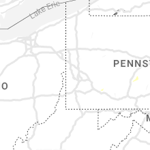
Pennsylvania
| Local Time | Report Details |
|---|---|
| 4:14 PM EDT | Picture of large tree down at the intersection of ryan ave and rowland ave in ne philadelphia. time estimated via rada in philadelphia county PA, 71.4 miles SW of Brooklyn, NY |
| 4:17 PM EDT | Tree down. time estimated from rada in chester county PA, 69.6 miles NE of Baltimore, MD |
| 4:27 PM EDT | Trees and wires down. time estimated from rada in chester county PA, 68.6 miles NE of Baltimore, MD |
| 4:30 PM EDT | Wires down. time estimated from rada in chester county PA, 69.4 miles NE of Baltimore, MD |
| 4:32 PM EDT | Measured mechanically and electronically a wind gust speed of 68.7mph with multiple tree limbs dow in chester county PA, 72 miles NE of Baltimore, MD |
| 4:38 PM EDT | Trees and wires down. time estimated from rada in chester county PA, 73.5 miles NE of Baltimore, MD |
| 4:53 PM EDT | Trees and wires down. time estimated from rada in chester county PA, 73.1 miles NE of Baltimore, MD |
| 5:03 PM EDT | Tree down. time estimated from rada in chester county PA, 82.7 miles NE of Baltimore, MD |
| 5:12 PM EDT | Report of a few trees knocked over and power lines down near the intersection of rt 100 and hanover street. time estimated via rada in chester county PA, 81.1 miles NE of Baltimore, MD |
| 7:19 PM EDT | 30 to 40 trees down along river forest road and river forest country club. power lines also down. microburst likely. time based on rada in westmoreland county PA, 22.3 miles NE of Pittsburgh, PA |
| 8:07 PM EDT | Tree down on the intersection of binkey road and four mile run roa in westmoreland county PA, 39.3 miles ESE of Pittsburgh, PA |
| 8:15 PM EDT | Tree down on marmont lan in westmoreland county PA, 40 miles ESE of Pittsburgh, PA |
| 8:38 PM EDT | Tree down across route 954 in south mahoning townshi in indiana county PA, 50 miles ENE of Pittsburgh, PA |
| 8:50 PM EDT | Tree down on route 553 in cherryhill townshi in indiana county PA, 54.7 miles ENE of Pittsburgh, PA |
| 8:53 PM EDT | Tree down along route 580 in green townshi in indiana county PA, 53.7 miles W of State College, PA |
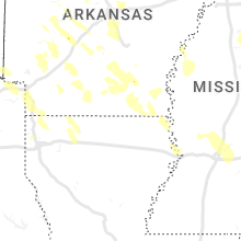
Arkansas
| Local Time | Report Details |
|---|---|
| 3:30 PM CDT | Golf Ball sized hail reported near Marshall, AR, 81.3 miles NNW of Little Rock, AR |
| 3:35 PM CDT | Tennis Ball sized hail reported near Ozone, AR, 61.3 miles ENE of Fort Smith, AR, picture received via social media. |
| 3:45 PM CDT | Softball sized hail reported near Marshall, AR, 79.2 miles N of Little Rock, AR, grapefruit size hail in thola. confirmed with a measurement. |
| 3:45 PM CDT | Tea Cup sized hail reported near Marshall, AR, 82.7 miles N of Little Rock, AR, 3.0 inch diameter hail in landis. picture sent via social media. |
| 3:45 PM CDT | Hen Egg sized hail reported near Marshall, AR, 81.1 miles NNW of Little Rock, AR |
| 3:52 PM CDT | Ping Pong Ball sized hail reported near Saint Paul, AR, 51 miles NE of Fort Smith, AR |
| 3:55 PM CDT | Tea Cup sized hail reported near Timbo, AR, 78 miles N of Little Rock, AR |
| 4:00 PM CDT | Quarter sized hail reported near Fox, AR, 72.5 miles N of Little Rock, AR, report from mping: quarter (1.00 in.). |
| 4:10 PM CDT | Quarter sized hail reported near Dover, AR, 69.1 miles NW of Little Rock, AR |
| 4:13 PM CDT | Golf Ball sized hail reported near Mountain View, AR, 78.5 miles N of Little Rock, AR, law enforcement reports golf ball size hail in downtown mountain view. |
| 4:15 PM CDT | Tea Cup sized hail reported near Mountain View, AR, 77.9 miles N of Little Rock, AR, 3.0 inch in diameter hail in mountain view. picture sent via social media. |
| 4:15 PM CDT | Corrects previous tstm wnd dmg report from allison. numerous trees down along highway 9 in alliso in stone county AR, 82.6 miles N of Little Rock, AR |
| 4:37 PM CDT | Golf Ball sized hail reported near Russellville, AR, 56.8 miles NW of Little Rock, AR |
| 4:43 PM CDT | Tea Cup sized hail reported near Atkins, AR, 51.6 miles NW of Little Rock, AR, report from mping: tea cup (3.00 in.). |
| 4:50 PM CDT | Quarter sized hail reported near Atkins, AR, 44.4 miles NW of Little Rock, AR |
| 4:53 PM CDT | Numerous trees down along highway 9 in alliso in stone county AR, 82.6 miles N of Little Rock, AR |
| 4:53 PM CDT | Trees down in atkins. quarter size hail was reported as wel in pope county AR, 51.6 miles NW of Little Rock, AR |
| 4:55 PM CDT | Power poles broken in cave cit in sharp county AR, 92.1 miles NNE of Little Rock, AR |
| 5:00 PM CDT | Numerous trees down in morrilton. trees are reported down in on two house in conway county AR, 38.8 miles NW of Little Rock, AR |
| 5:06 PM CDT | Spotter estimated 70 mph wind gusts just south of oppelo. numerous trees dow in conway county AR, 36.7 miles NW of Little Rock, AR |
| 5:10 PM CDT | Power poles blown dow in faulkner county AR, 33.4 miles NNW of Little Rock, AR |
| 5:15 PM CDT | Numerous trees blown down through the city of conwa in faulkner county AR, 25.6 miles NNW of Little Rock, AR |
| 5:20 PM CDT | Trees down in tuckerman. estimated 60 mph wind in jackson county AR, 76.3 miles WNW of Memphis, TN |
| 5:23 PM CDT | Measured 68 mph wind gusts in swifton. quarter size also reported. numerous trees uproote in jackson county AR, 76.9 miles NW of Memphis, TN |
| 5:35 PM CDT | Numerous trees blown down in burns park. trained storm spotter estimates the winds to be 70 mph. time estimated off rada in pulaski county AR, 4.7 miles NNW of Little Rock, AR |
| 5:36 PM CDT | Corrects previous tstm wnd dmg report from 2 w vilonia. power poles broken and large trees down in and near viloni in faulkner county AR, 22.9 miles N of Little Rock, AR |
| 5:37 PM CDT | Numerous trees and powerlines reported down through out the city of sherwoo in pulaski county AR, 7.3 miles NNE of Little Rock, AR |
| 5:37 PM CDT | Quarter sized hail reported near Walnut Ridge, AR, 76.6 miles NW of Memphis, TN |
| 5:39 PM CDT | Numerous tree and power lines down across bono a in craighead county AR, 67.4 miles NW of Memphis, TN |
| 5:45 PM CDT | Powerlines blown down in cabo in lonoke county AR, 21 miles NE of Little Rock, AR |
| 5:45 PM CDT | Numerous trees and powerlines down throughout the cit in pulaski county AR, 3.2 miles NNE of Little Rock, AR |
| 5:45 PM CDT | Tree down in the southbound lane of highway 67 in austi in lonoke county AR, 24.1 miles NE of Little Rock, AR |
| 5:45 PM CDT | Trees blown over in gu in faulkner county AR, 40.2 miles N of Little Rock, AR |
| 5:45 PM CDT | Corrects previous tstm wnd dmg report from 2 nw jonesboro. asos report of gust of 51.0 knots. reports of trees and fences down across tow in craighead county AR, 60.4 miles NW of Memphis, TN |
| 5:45 PM CDT | Corrects previous tstm wnd gst report from 2 nw jonesboro. corrects previous tstm wnd dmg report from 2 nw jonesboro. asos report of gust of 51.0 knots. reports of tree in craighead county AR, 57.9 miles NW of Memphis, TN |
| 5:46 PM CDT | 60 kt wind gust measured at kli in pulaski county AR, 3.4 miles ESE of Little Rock, AR |
| 5:52 PM CDT | 1-inch tree limbs broken; shingles blown of in craighead county AR, 58.8 miles NW of Memphis, TN |
| 5:53 PM CDT | Asos report of gust of 51.0 knot in craighead county AR, 60.4 miles NW of Memphis, TN |
| 5:53 PM CDT | Numerous trees and powerlines down across brookland a in craighead county AR, 59.8 miles NNW of Memphis, TN |
| 5:55 PM CDT | Trees down in the area and some roof damage on a few home in pulaski county AR, 10.5 miles ESE of Little Rock, AR |
| 5:55 PM CDT | Reports of numerous trees down in the maple grove and hatchie coon areas south of truman in poinsett county AR, 43.2 miles NW of Memphis, TN |
| 5:58 PM CDT | Trees uprooted or snappe in pulaski county AR, 10.9 miles NNW of Little Rock, AR |
| 6:00 PM CDT | Numerous trees and powerlines blown down between scott and keo along toltec roa in lonoke county AR, 14.2 miles ESE of Little Rock, AR |
| 6:02 PM CDT | Power lines down... irrigation pivots blown ove in poinsett county AR, 35.2 miles NW of Memphis, TN |
| 6:05 PM CDT | Large tree dow in poinsett county AR, 37.6 miles NW of Memphis, TN |
| 6:06 PM CDT | Power poles broken in lonok in lonoke county AR, 23 miles ENE of Little Rock, AR |
| 6:07 PM CDT | Quarter sized hail reported near Morrilton, AR, 37.6 miles NW of Little Rock, AR, in addition to the hail... winds were estimated to be 50 mph. |
| 6:10 PM CDT | Widespread wind damage in marked tree. many trees are uprooted or snapped... some falling on homes. fences and utility poles downed and some structures sustained damage in poinsett county AR, 33.6 miles NW of Memphis, TN |
| 6:13 PM CDT | Many trees down on highway 77 south of route 11 in mississippi county AR, 27.3 miles NNW of Memphis, TN |
| 6:15 PM CDT | Measured wind gust of 76 mph with minor damage to a hange in lonoke county AR, 26.8 miles ESE of Little Rock, AR |
| 6:15 PM CDT | Several utility poles and numerous trees dow in poinsett county AR, 29.3 miles NW of Memphis, TN |
| 6:20 PM CDT | A tree was blown down on highway 1 in jefferson county AR, 28.4 miles SE of Little Rock, AR |
| 6:30 PM CDT | Semi across i-55 near mile marker 3 in mississippi county AR, 27.1 miles NNW of Memphis, TN |
| 6:30 PM CDT | Tress across railroa in mississippi county AR, 29 miles N of Memphis, TN |
| 6:35 PM CDT | Report from mping: trees uprooted or snapped; roof blown of in crittenden county AR, 16.3 miles NNW of Memphis, TN |
| 6:35 PM CDT | Numerous trees down in humphre in arkansas county AR, 39.4 miles SE of Little Rock, AR |
| 6:36 PM CDT | Power poles broken and large trees down in and near viloni in faulkner county AR, 22.9 miles N of Little Rock, AR |
| 6:40 PM CDT | Trees down across ul in prairie county AR, 47.8 miles ESE of Little Rock, AR |
| 7:04 PM CDT | Trees and powerlines down in de wit in arkansas county AR, 62 miles ESE of Little Rock, AR |
| 7:51 PM CDT | Trees uprooted or snappe in arkansas county AR, 53.3 miles ESE of Little Rock, AR |
| 8:00 PM CDT | Power poles broke in arkansas county AR, 65 miles ESE of Little Rock, AR |
| 8:48 PM CDT | Trees and power lines dow in chicot county AR, 59.2 miles NNE of Bastrop, LA |
| 9:25 PM CDT | Trees and power lines dow in chicot county AR, 46 miles ENE of Bastrop, LA |
| 9:30 PM CDT | A tree fell near a home in eudora. report and picture relayed via faceboo in chicot county AR, 44.8 miles ENE of Bastrop, LA |
| 10:23 PM CDT | Quarter sized hail reported near Hot Springs National Park, AR, 47.4 miles WSW of Little Rock, AR |
| 10:55 PM CDT | Half Dollar sized hail reported near Malvern, AR, 39.7 miles SW of Little Rock, AR |
| 6:00 AM CDT | Trees and power lines down just north of doddridge a in miller county AR, 40.6 miles NNW of Shreveport, LA |
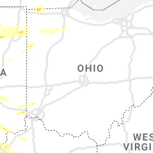
Ohio
| Local Time | Report Details |
|---|---|
| 4:52 PM EDT | Several limbs downed that were between 3-8 inches in diameter... estimated wind gust of 50 to 60 mp in williams county OH, 50.5 miles NE of Fort Wayne, IN |
| 5:36 PM EDT | Several 6 to 8 inch diameter limbs downed... minor crop damage from strong winds. estimated wind gust to 50 to 60 mp in williams county OH, 35.9 miles NNE of Fort Wayne, IN |
| 5:39 PM EDT | Per county dispatch... emergency manager reports a tree that fell onto an occupied van with 3 kids and 1 adult female inside. no major injuries reported but occupants w in fulton county OH, 67.7 miles ENE of Fort Wayne, IN |
| 5:59 PM EDT | Utility wires dow in lucas county OH, 84.5 miles ENE of Fort Wayne, IN |
| 6:01 PM EDT | 30 to 40 foot 8 diameter limb dow in lucas county OH, 90.1 miles ENE of Fort Wayne, IN |
| 6:03 PM EDT | Second story window blown out of its frame and into the living quarter in lucas county OH, 88.8 miles ENE of Fort Wayne, IN |
| 6:05 PM EDT | Large branch dow in lucas county OH, 84.5 miles ENE of Fort Wayne, IN |
| 6:05 PM EDT | Utility wires dow in lucas county OH, 86.6 miles ENE of Fort Wayne, IN |
| 6:06 PM EDT | Powerlines and tree limbs down on 830 walnut street in new bavaria... oh. time estimated from rada in henry county OH, 49.3 miles E of Fort Wayne, IN |
| 6:07 PM EDT | Several instances of storm damage in the point place area of toledo. a large portion of a tree fell on 131st street. a fence was blown apart and a tree limb fell at a r in lucas county OH, 89.8 miles S of Flint, MI |
| 6:08 PM EDT | Large branch and wires dow in lucas county OH, 88.8 miles ENE of Fort Wayne, IN |
| 6:19 PM EDT | A couple of trees dow in wood county OH, 73.4 miles ENE of Fort Wayne, IN |
| 6:44 PM EDT | Tree dow in sandusky county OH, 85.1 miles W of Cleveland, OH |
| 7:14 PM EDT | Mesonet station xsdb 2 nne sandusk in lez144 county OH, 52.4 miles W of Cleveland, OH |
| 7:15 PM EDT | Large tree dow in ottawa county OH, 59 miles W of Cleveland, OH |
| 8:19 PM EDT | Report from mping: 3-inch tree limbs broken; power poles broke in fulton county OH, 60.5 miles NE of Fort Wayne, IN |
South Carolina
| Local Time | Report Details |
|---|---|
| 4:59 PM EDT | Tree down southeast of travelers rest. time and location estimated by rada in greenville county SC, 16.4 miles ENE of Greenville, SC |
| 5:09 PM EDT | Large tree down across artillery roa in greenville county SC, 15.5 miles ENE of Greenville, SC |
| 5:10 PM EDT | Multiple trees down... a power line is down and a tree fell on top of a storage buildin in greenville county SC, 17.9 miles ENE of Greenville, SC |
| 5:12 PM EDT | Widespread power outages in the reid school rd area attributed to storm in greenville county SC, 17.3 miles ENE of Greenville, SC |
| 7:00 PM EDT | Multiple trees down along kings r in anderson county SC, 19 miles S of Greenville, SC |
| 7:44 PM EDT | Multiple trees across the roa in greenwood county SC, 43.6 miles N of Augusta, GA |
Virginia
| Local Time | Report Details |
|---|---|
| 5:09 PM EDT | Personal weather station measured a gust to 80 mph. a video showed intense wind. there were snapped trees... branches down... and a pop up camper was thrown by the wind in city of portsmouth county VA, 17.4 miles WNW of Virginia Beach, VA |
| 5:23 PM EDT | Quarter sized hail reported near Norfolk, VA, 9.4 miles NW of Virginia Beach, VA, photo of quarter size hail near newtown rd in va beach. time estimated from radar. |
Idaho
| Local Time | Report Details |
|---|---|
| 4:40 PM MDT | Mesonet station bas base of howe pea in butte county ID, 50.3 miles WNW of Idaho Falls, ID |
Mississippi
| Local Time | Report Details |
|---|---|
| 7:22 PM CDT | Powerlines down in slayden near highway 7 in marshall county MS, 37.2 miles ESE of Memphis, TN |
| 7:40 PM CDT | Corrects previous tstm wnd dmg report from clarksdale. numerous large trees and power lines down in clarksdale. damage to street signs... stoplights... and utility pole in coahoma county MS, 72.1 miles SSW of Memphis, TN |
| 7:45 PM CDT | Trees down across tow in benton county MS, 54 miles ESE of Memphis, TN |
| 7:50 PM CDT | Numerous trees down across town. a few utility poles were snapped and some structures sustained minor damage to roofs and tri in tippah county MS, 66.6 miles ESE of Memphis, TN |
| 7:52 PM CDT | Numerous trees down in the chalybeate area. widespread power outage in tippah county MS, 68.5 miles W of Florence, AL |
| 7:55 PM CDT | Numerous trees snapped or uprooted in the tiplersville communit in tippah county MS, 66.8 miles ESE of Memphis, TN |
| 7:55 PM CDT | Numerous trees and power lines down across ripley. the roof was blown off a she in tippah county MS, 68.8 miles ESE of Memphis, TN |
| 8:15 PM CDT | Light pole and cable wire dow in humphreys county MS, 64 miles NNW of Jackson, MS |
| 8:15 PM CDT | Large tree down on home... causing damage to the structur in alcorn county MS, 53.2 miles W of Florence, AL |
| 8:26 PM CDT | Corrects previous tstm wnd dmg report from baldwyn. trees down on hwy 370 west and east of baldwy in lee county MS, 58.2 miles WSW of Florence, AL |
| 8:26 PM CDT | Trees down on county rd. 30 in lafayette county MS, 62.3 miles SSE of Memphis, TN |
| 8:28 PM CDT | Numerous trees down across the count in prentiss county MS, 51.8 miles W of Florence, AL |
| 8:35 PM CDT | Trees were reported down in west grenada count in grenada county MS, 73.6 miles WNW of Starkville, MS |
| 8:35 PM CDT | A home was reported damaged in west grenada count in grenada county MS, 78 miles WNW of Starkville, MS |
| 8:40 PM CDT | Multiple trees and powerlines down in guntow in lee county MS, 61.4 miles WSW of Florence, AL |
| 8:45 PM CDT | Several trees down in iuka. estimated wind gusts near 60 mp in tishomingo county MS, 29.8 miles W of Florence, AL |
| 8:50 PM CDT | Tree down on county rd. 42 in lafayette county MS, 61.7 miles NNW of Starkville, MS |
| 8:50 PM CDT | Power lines down in itta bena. reported via social medi in leflore county MS, 83.2 miles N of Jackson, MS |
| 8:58 PM CDT | Tress down across the city of fulton near hwy 37 in itawamba county MS, 55.7 miles SW of Florence, AL |
| 9:00 PM CDT | Trees down in sidon. reported via social medi in leflore county MS, 76.6 miles N of Jackson, MS |
| 9:15 PM CDT | Corrects previous tstm wnd dmg report from belzoni. light pole and cable wire dow in humphreys county MS, 64 miles NNW of Jackson, MS |
| 9:15 PM CDT | Report from mping: 3-inch tree limbs broken; power poles broke in carroll county MS, 59.1 miles WSW of Starkville, MS |
| 10:40 PM CDT | Trees down across the are in madison county MS, 16 miles NNE of Jackson, MS |
| 10:55 PM CDT | Report from mping similar to 1-inch tree limbs broken; shingles blown of in hinds county MS, 5.2 miles NNE of Jackson, MS |
| 11:04 PM CDT | Asos sites reported peak sustained winds at 56 mph with gusts up to 76 mp in rankin county MS, 6.1 miles ENE of Jackson, MS |
| 11:05 PM CDT | Khks asos site reported sustained winds of 33 mph with gusts up to 57 mp in hinds county MS, 4.1 miles NW of Jackson, MS |
| 11:05 PM CDT | Quarter sized hail reported near Ridgeland, MS, 9.6 miles NNE of Jackson, MS, nws employee reported quarter size hail in north jackson along old canton rd. |
| 11:09 PM CDT | A tree was blown down onto the road near the intersection of ms highways 468 and 46 in rankin county MS, 9.5 miles ESE of Jackson, MS |
| 11:14 PM CDT | Report from mping of wind damage similar to 3-inch tree limbs broken; power poles broke in rankin county MS, 8.2 miles E of Jackson, MS |
| 11:14 PM CDT | Two trees were blown down at the highpointe apartment in rankin county MS, 9.5 miles E of Jackson, MS |
| 11:15 PM CDT | Large limbs down on mississippi state university campus. reported via social medi in oktibbeha county MS, 1.3 miles SE of Starkville, MS |
| 11:16 PM CDT | Quarter sized hail reported near Brandon, MS, 12.5 miles E of Jackson, MS, report from mping: quarter (1.00 in.). |
| 11:28 PM CDT | Trees down on power lines on old hwy 8 in scott county MS, 32.4 miles E of Jackson, MS |
| 11:30 PM CDT | A tree fell onto and damaged a trailer home in the 2800 block of cato road near the simpson county lin in rankin county MS, 24.6 miles SE of Jackson, MS |
| 11:50 PM CDT | Tree down near hwy 18 and hwy 53 in jasper county MS, 55.6 miles ESE of Jackson, MS |
| 11:55 PM CDT | Tree down on cr 1 in jasper county MS, 61 miles ESE of Jackson, MS |
| 12:10 AM CDT | Tree down on cr 13 in jasper county MS, 53.3 miles ESE of Jackson, MS |
| 12:20 AM CDT | Tree down near hwy 11 and palmer roa in jones county MS, 73.8 miles SE of Jackson, MS |
| 12:20 AM CDT | Tree blocking the road near 7th avenue and 9th stree in jones county MS, 74.2 miles ESE of Jackson, MS |
| 12:21 AM CDT | Snapped power pole on rose lan in jones county MS, 72 miles SE of Jackson, MS |
| 12:26 AM CDT | Numerous trees down in the laurel/ellisville vicinit in jones county MS, 74.3 miles SE of Jackson, MS |
| 12:26 AM CDT | Tree fell on mobile hom in jones county MS, 74.4 miles SE of Jackson, MS |
| 12:31 AM CDT | *** 2 inj *** tree fell on mobile home and 2 people injure in jones county MS, 81.8 miles SE of Jackson, MS |
Texas
| Local Time | Report Details |
|---|---|
| 7:50 PM CDT | The koza asos reported a 56 kt gust from the outflow of a collapsing thunderstor in crockett county TX, 95.7 miles N of Del Rio, TX |
Florida
| Local Time | Report Details |
|---|---|
| 4:29 AM CDT | Awos station kvps at eglin afb gusted to 67 mp in okaloosa county FL, 11.5 miles NW of Miramar Beach, FL |
| 4:55 AM CDT | Downed tree on state highway 20 west in walton county florida. reported by the 911 call cente in walton county FL, 13.4 miles NE of Miramar Beach, FL |
South Dakota
| Local Time | Report Details |
|---|---|
| 5:40 AM MDT | Storm damage reported in fall river county SD, 77.3 miles SSW of Rapid City, SD |
Connect with Interactive Hail Maps