

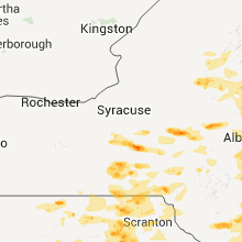
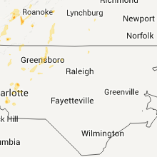
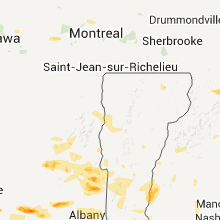
Hail Map for Thursday, June 9, 2011

Number of Impacted Households on 6/9/2011
0
Impacted by 1" or Larger Hail
0
Impacted by 1.75" or Larger Hail
0
Impacted by 2.5" or Larger Hail
Square Miles of Populated Area Impacted on 6/9/2011
0
Impacted by 1" or Larger Hail
0
Impacted by 1.75" or Larger Hail
0
Impacted by 2.5" or Larger Hail


Cities Most Affected by Hail Storms of 6/9/2011
| Hail Size | Demographics of Zip Codes Affected | ||||||
|---|---|---|---|---|---|---|---|
| City | Count | Average | Largest | Pop Density | House Value | Income | Age |
| South Otselic, NY | 4 | 2.38 | 3.00 | 18 | $44k | $34.2k | 38.2 |
| Trenton, MO | 4 | 2.19 | 2.75 | 37 | $48k | $27.3k | 42.5 |
| Rothville, MO | 3 | 2.83 | 3.00 | 6 | $24k | $32.5k | 41.2 |
| Mount Hope, KS | 2 | 3.50 | 4.25 | 18 | $77k | $46.5k | 39.9 |
| Des Moines, IA | 3 | 1.75 | 1.75 | 2160 | $70k | $34.5k | 35.0 |
| Wappingers Falls, NY | 3 | 1.75 | 1.75 | 1042 | $160k | $59.4k | 40.5 |
| Gallatin, MO | 2 | 2.13 | 2.50 | 25 | $68k | $32.7k | 42.7 |
| West Winfield, NY | 2 | 1.88 | 2.00 | 44 | $70k | $35.4k | 42.3 |
| State Center, IA | 2 | 1.75 | 1.75 | 17 | $78k | $43.3k | 39.1 |
| New Cambria, MO | 2 | 1.75 | 1.75 | 6 | $29k | $28.3k | 46.8 |
| Wichita, KS | 2 | 1.75 | 1.75 | 3596 | $99k | $52.0k | 37.8 |
| Onaga, KS | 2 | 1.75 | 1.75 | 7 | $49k | $31.2k | 42.7 |
| Hopewell Junction, NY | 2 | 1.75 | 1.75 | 523 | $197k | $72.0k | 40.8 |
| Lock Springs, MO | 1 | 3.00 | 3.00 | 0 | $0k | $0.0k | 38.0 |
| Bucklin, MO | 1 | 2.75 | 2.75 | 12 | $30k | $26.1k | 48.5 |
| Jamesport, MO | 1 | 2.75 | 2.75 | 18 | $41k | $25.8k | 29.6 |
| Atlanta, MO | 1 | 2.75 | 2.75 | 9 | $34k | $34.8k | 40.4 |
| Hallowell, ME | 1 | 2.50 | 2.50 | 386 | $92k | $36.1k | 50.6 |
| Moravia, NY | 1 | 2.00 | 2.00 | 44 | $72k | $39.5k | 39.2 |
| Callao, MO | 1 | 2.00 | 2.00 | 10 | $27k | $31.0k | 45.9 |
| Cherokee, OK | 1 | 2.00 | 2.00 | 8 | $33k | $30.3k | 45.3 |
| Washington, NH | 1 | 2.00 | 2.00 | 24 | $111k | $44.1k | 46.5 |
| Cheyenne, OK | 1 | 2.00 | 2.00 | 3 | $52k | $28.7k | 39.7 |
| Queensbury, NY | 1 | 2.00 | 2.00 | 504 | $113k | $47.2k | 44.4 |
| Norwood, NJ | 1 | 1.75 | 1.75 | 2024 | $345k | $92.8k | 46.1 |
| Clymer, PA | 1 | 1.75 | 1.75 | 90 | $54k | $30.7k | 41.4 |
| Binghamton, NY | 1 | 1.75 | 1.75 | 837 | $78k | $31.4k | 41.1 |
| Norfolk, CT | 1 | 1.75 | 1.75 | 21 | $168k | $58.1k | 47.5 |
| Haven, KS | 1 | 1.75 | 1.75 | 17 | $74k | $41.5k | 38.7 |
| Jermyn, PA | 1 | 1.75 | 1.75 | 250 | $91k | $34.8k | 43.0 |
| Mutual, OK | 1 | 1.75 | 1.75 | 3 | $43k | $39.4k | 42.5 |
| Lagrangeville, NY | 1 | 1.75 | 1.75 | 231 | $186k | $69.4k | 42.4 |
| Arapaho, OK | 1 | 1.75 | 1.75 | 4 | $44k | $36.0k | 38.4 |
| Argyle, NY | 1 | 1.75 | 1.75 | 62 | $86k | $41.2k | 44.1 |
| Humphreys, MO | 1 | 1.75 | 1.75 | 5 | $20k | $32.1k | 47.9 |
| Montgomery, NY | 1 | 1.75 | 1.75 | 257 | $142k | $57.8k | 40.3 |
| Augusta, WV | 1 | 1.75 | 1.75 | 44 | $82k | $30.9k | 39.6 |
| Newburgh, NY | 1 | 1.75 | 1.75 | 1546 | $130k | $42.3k | 34.2 |
| Hayesville, NC | 1 | 1.75 | 1.75 | 45 | $104k | $31.0k | 50.2 |
| Keaton, KY | 1 | 1.75 | 1.75 | 35 | $24k | $20.8k | 43.0 |
| Pleasant Hill, IA | 1 | 1.75 | 1.75 | 578 | $0k | $0.0k | 36.4 |
| Bentley, KS | 1 | 1.75 | 1.75 | 0 | $53k | $40.6k | 35.2 |
| Homer, NY | 1 | 1.75 | 1.75 | 93 | $81k | $41.0k | 41.5 |
| Ankeny, IA | 1 | 1.75 | 1.75 | 1337 | $0k | $0.0k | 31.7 |
| Urbandale, IA | 1 | 1.75 | 1.75 | 2954 | $127k | $57.3k | 39.4 |
| Garden Plain, KS | 1 | 1.75 | 1.75 | 29 | $93k | $51.3k | 36.5 |
| Waynoka, OK | 1 | 1.75 | 1.75 | 4 | $26k | $23.7k | 45.2 |
| Pitcher, NY | 1 | 1.75 | 1.75 | 20 | $40k | $33.9k | 41.4 |
| Brookfield, MO | 1 | 1.75 | 1.75 | 40 | $47k | $28.0k | 41.5 |
| Poughquag, NY | 1 | 1.75 | 1.75 | 327 | $195k | $74.9k | 40.4 |
Hail and Wind Damage Spotted on 6/9/2011
Filter by Report Type:Hail ReportsWind Reports
States Impacted
Nebraska, New York, Iowa, Vermont, Connecticut, Missouri, North Carolina, Kentucky, Tennessee, Maine, Pennsylvania, New Hampshire, Virginia, Massachusetts, Georgia, South Carolina, West Virginia, New Jersey, Kansas, Maryland, Oklahoma, Ohio, DelawareNebraska
| Local Time | Report Details |
|---|---|
| 12:07 PM UTC | Golf Ball sized hail reported near , , 11.7 miles SE of North Platte, NE, quarter to golf ball sized hail occurring at time report. |
| 12:14 PM UTC | Quarter sized hail reported near Paxton, NE, 31.2 miles W of North Platte, NE, ground covered by hail. mostly pea sized hail but largest stones are size of quarters. hail had persisted for ten minutes. |
| 12:38 PM UTC | Quarter sized hail reported near Sutherland, NE, 23.8 miles W of North Platte, NE |
| 12:44 PM UTC | Quarter sized hail reported near Sutherland, NE, 21.3 miles W of North Platte, NE |
| 1:07 PM UTC | Quarter sized hail reported near Merna, NE, 47.7 miles ENE of North Platte, NE |
| 1:50 PM UTC | Quarter sized hail reported near Ericson, NE, 48.9 miles S of Oneill, NE, mainly penny to nickel size hail with a few to the size of quarters. |
| 5:19 PM UTC | Quarter sized hail reported near West Point, NE, 58.5 miles NW of Omaha, NE |
| 2:10 AM UTC | Quarter sized hail reported near Pawnee City, NE, 67.2 miles NNE of Manhattan, KS |
| 2:12 AM UTC | Quarter sized hail reported near Pawnee City, NE, 67.9 miles NNE of Manhattan, KS, heavy rain reported by fire chief. |
| 3:28 AM UTC | In old towne bellevue. relayed via faceboo in sarpy county NE, 7.8 miles SSE of Omaha, NE |
New York
| Local Time | Report Details |
|---|---|
| 12:23 PM UTC | Quarter sized hail reported near Ticonderoga, NY, 44.4 miles SSW of Burlington, VT |
| 4:45 PM UTC | Hen Egg sized hail reported near Otselic, NY, 33.3 miles SE of Syracuse, NY |
| 4:49 PM UTC | Ping Pong Ball sized hail reported near Bridgewater, NY, 48.8 miles ESE of Syracuse, NY |
| 4:50 PM UTC | Quarter sized hail reported near , , 33 miles WNW of Schenectady, NY |
| 4:50 PM UTC | Tennis Ball sized hail reported near Otselic, NY, 33.3 miles SE of Syracuse, NY |
| 4:53 PM UTC | Quarter sized hail reported near Lake Pleasant, NY, 62.1 miles NNW of Schenectady, NY |
| 4:58 PM UTC | Golf Ball sized hail reported near West Winfield, NY, 49.9 miles ESE of Syracuse, NY |
| 5:00 PM UTC | Quarter sized hail reported near West Winfield, NY, 49.9 miles ESE of Syracuse, NY |
| 5:00 PM UTC | Hen Egg sized hail reported near Sempronius, NY, 23.8 miles SSW of Syracuse, NY |
| 5:03 PM UTC | Golf Ball sized hail reported near Scott, NY, 22.5 miles S of Syracuse, NY, hail lasted for 8-9 minutes |
| 5:05 PM UTC | Quarter sized hail reported near Dryden, NY, 39.4 miles SSW of Syracuse, NY |
| 5:10 PM UTC | Half Dollar sized hail reported near Scott, NY, 22.5 miles S of Syracuse, NY |
| 5:13 PM UTC | Quarter sized hail reported near Richfield, NY, 54.4 miles W of Schenectady, NY |
| 5:15 PM UTC | Ping Pong Ball sized hail reported near Eaton, NY, 28.3 miles ESE of Syracuse, NY, childrens ctr. |
| 5:20 PM UTC | Quarter sized hail reported near Caroline, NY, 46.9 miles S of Syracuse, NY |
| 5:22 PM UTC | Several trees down in warren county NY, 49.6 miles N of Schenectady, NY |
| 5:27 PM UTC | Several trees down in warren county NY, 52.1 miles NNE of Schenectady, NY |
| 5:28 PM UTC | Hen Egg sized hail reported near West Winfield, NY, 49.9 miles ESE of Syracuse, NY |
| 5:30 PM UTC | Trees on power lines on youngs road in essex county NY, 23.3 miles SSW of Burlington, VT |
| 5:39 PM UTC | Quarter sized hail reported near Cherry Valley, NY, 41.1 miles W of Schenectady, NY |
| 5:40 PM UTC | Quarter sized hail reported near Caroline, NY, 46.9 miles S of Syracuse, NY |
| 5:40 PM UTC | Quarter sized hail reported near Cherry Valley, NY, 41.1 miles W of Schenectady, NY |
| 5:45 PM UTC | Half Dollar sized hail reported near Pharsalia, NY, 37.9 miles SE of Syracuse, NY |
| 5:45 PM UTC | Golf Ball sized hail reported near Pitcher, NY, 34 miles SSE of Syracuse, NY, also gusty winds with a few limbs down |
| 5:45 PM UTC | Tea Cup sized hail reported near Otselic, NY, 33.3 miles SE of Syracuse, NY |
| 5:50 PM UTC | Hen Egg sized hail reported near Otselic, NY, 33.3 miles SE of Syracuse, NY |
| 5:55 PM UTC | Ping Pong Ball sized hail reported near Mohawk, NY, 25.6 miles WNW of Schenectady, NY, weathernet 6 |
| 6:05 PM UTC | Quarter sized hail reported near Johnstown, NY, 25.7 miles WNW of Schenectady, NY |
| 6:15 PM UTC | Quarter sized hail reported near Perth, NY, 18.6 miles NW of Schenectady, NY |
| 6:15 PM UTC | Quarter sized hail reported near Queensbury, NY, 40.4 miles NNE of Schenectady, NY |
| 6:18 PM UTC | Quarter sized hail reported near Nanticoke, NY, 55 miles S of Syracuse, NY |
| 6:19 PM UTC | Golf Ball sized hail reported near Chenango, NY, 57.6 miles N of Scranton, PA, wbng-tv |
| 6:20 PM UTC | Quarter sized hail reported near Amsterdam, NY, 15.4 miles NW of Schenectady, NY |
| 6:20 PM UTC | Quarter sized hail reported near Perth, NY, 18.6 miles NW of Schenectady, NY |
| 6:25 PM UTC | Ping Pong Ball sized hail reported near Nanticoke, NY, 53.3 miles S of Syracuse, NY |
| 6:26 PM UTC | Hen Egg sized hail reported near Queensbury, NY, 40.4 miles NNE of Schenectady, NY |
| 6:40 PM UTC | Half Dollar sized hail reported near Northumberland, NY, 30.6 miles NNE of Schenectady, NY |
| 6:40 PM UTC | Half Dollar sized hail reported near Queensbury, NY, 41.2 miles NNE of Schenectady, NY |
| 6:45 PM UTC | Trees and wires down in rensselaer county NY, 20 miles ESE of Schenectady, NY |
| 6:45 PM UTC | Trees and wires down in rensselaer county NY, 14.4 miles ESE of Schenectady, NY |
| 6:45 PM UTC | Tree limbs down in rensselaer county NY, 21.8 miles SSE of Schenectady, NY |
| 6:48 PM UTC | Quarter sized hail reported near Fort Edward, NY, 36.5 miles NNE of Schenectady, NY |
| 6:48 PM UTC | Quarter sized hail reported near Kirkwood, NY, 43.2 miles N of Scranton, PA |
| 6:50 PM UTC | Golf Ball sized hail reported near Argyle, NY, 37.3 miles NE of Schenectady, NY |
| 6:51 PM UTC | Quarter sized hail reported near Northumberland, NY, 30.6 miles NNE of Schenectady, NY |
| 7:15 PM UTC | Trees and wires down in greene county NY, 31.7 miles S of Schenectady, NY |
| 7:15 PM UTC | Trees and wires down in rensselaer county NY, 14.4 miles ESE of Schenectady, NY |
| 7:15 PM UTC | Tree limbs down in rensselaer county NY, 21.8 miles SSE of Schenectady, NY |
| 7:27 PM UTC | Trees down in delaware county NY, 42.1 miles NNE of Scranton, PA |
| 7:30 PM UTC | Power lines down in delaware county NY, 46.2 miles NNE of Scranton, PA |
| 7:33 PM UTC | Trees and wires down in columbia county NY, 35.7 miles SSE of Schenectady, NY |
| 7:38 PM UTC | Quarter sized hail reported near Montgomery, NY, 58.6 miles NNW of Brooklyn, NY |
| 7:44 PM UTC | Golf Ball sized hail reported near Montgomery, NY, 58.6 miles NNW of Brooklyn, NY, montgomery airport |
| 7:45 PM UTC | Ping Pong Ball sized hail reported near Montgomery, NY, 58.6 miles NNW of Brooklyn, NY, montgomery airport |
| 7:50 PM UTC | Trees and wires down on county rte. 28 in delaware county NY, 46.2 miles NNE of Scranton, PA |
| 7:50 PM UTC | Trees across rte. 97 five miles south of hancock in delaware county NY, 42.1 miles NNE of Scranton, PA |
| 7:56 PM UTC | Wires down in columbia county NY, 30.3 miles SSE of Schenectady, NY |
| 8:00 PM UTC | Many trees down on cars and streets and power outages in orange county NY, 58.6 miles NNW of Brooklyn, NY |
| 8:05 PM UTC | Trees and wires down in columbia county NY, 36.7 miles SE of Schenectady, NY |
| 8:07 PM UTC | Golf Ball sized hail reported near East Fishkill, NY, 60 miles N of Brooklyn, NY |
| 8:08 PM UTC | Quarter sized hail reported near Newburgh, NY, 55.7 miles N of Brooklyn, NY |
| 8:08 PM UTC | Trees...tree limbs and power lines down around 1-84 in newburgh in orange county NY, 55.7 miles N of Brooklyn, NY |
| 8:09 PM UTC | Quarter sized hail reported near Newburgh, NY, 55.7 miles N of Brooklyn, NY |
| 8:10 PM UTC | Golf Ball sized hail reported near Newburgh, NY, 55.7 miles N of Brooklyn, NY |
| 8:10 PM UTC | Trees and wires down in orange county NY, 55.7 miles N of Brooklyn, NY |
| 8:15 PM UTC | Quarter sized hail reported near Beacon, NY, 55.7 miles N of Brooklyn, NY |
| 8:17 PM UTC | Quarter sized hail reported near East Fishkill, NY, 62.7 miles N of Brooklyn, NY |
| 8:20 PM UTC | Trees and wires down county wid in sullivan county NY, 53 miles ENE of Scranton, PA |
| 8:20 PM UTC | Half Dollar sized hail reported near East Fishkill, NY, 62.7 miles N of Brooklyn, NY |
| 8:20 PM UTC | Golf Ball sized hail reported near Fishkill, NY, 57.8 miles N of Brooklyn, NY |
| 8:24 PM UTC | Golf Ball sized hail reported near East Fishkill, NY, 62.7 miles N of Brooklyn, NY |
| 8:26 PM UTC | Quarter sized hail reported near Wappingers Falls, NY, 62.7 miles N of Brooklyn, NY |
| 8:28 PM UTC | Ping Pong Ball sized hail reported near Beacon, NY, 55.7 miles N of Brooklyn, NY |
| 8:32 PM UTC | Trees and wires down in dutchess county NY, 69.8 miles NNE of Brooklyn, NY |
| 8:40 PM UTC | Quarter sized hail reported near Wappingers Falls, NY, 62.7 miles N of Brooklyn, NY |
| 8:41 PM UTC | Quarter sized hail reported near East Fishkill, NY, 62.7 miles N of Brooklyn, NY |
| 8:42 PM UTC | Golf Ball sized hail reported near Beekman, NY, 65 miles NNE of Brooklyn, NY |
| 8:43 PM UTC | Golf Ball sized hail reported near Wappingers Falls, NY, 62.7 miles N of Brooklyn, NY |
| 8:49 PM UTC | Quarter sized hail reported near Amenia, NY, 75.6 miles SSE of Schenectady, NY |
| 8:53 PM UTC | Trees and limbs down in dutchess county NY, 75.6 miles SSE of Schenectady, NY |
| 8:53 PM UTC | Numerous tree limbs down in dutchess county NY, 67.2 miles N of Brooklyn, NY |
| 8:53 PM UTC | Golf Ball sized hail reported near La Grange, NY, 67.2 miles N of Brooklyn, NY |
| 8:55 PM UTC | Trees down in dutchess county NY, 62.7 miles N of Brooklyn, NY |
| 8:57 PM UTC | Quarter sized hail reported near Beacon, NY, 55.7 miles N of Brooklyn, NY |
| 8:58 PM UTC | Quarter sized hail reported near East Fishkill, NY, 62.7 miles N of Brooklyn, NY |
| 8:58 PM UTC | Quarter sized hail reported near Wappinger, NY, 63.6 miles N of Brooklyn, NY |
| 9:00 PM UTC | Tree down in dutchess county NY, 55.7 miles N of Brooklyn, NY |
| 9:01 PM UTC | Quarter sized hail reported near Fishkill, NY, 58 miles N of Brooklyn, NY |
| 9:01 PM UTC | Ping Pong Ball sized hail reported near Wappingers Falls, NY, 62.7 miles N of Brooklyn, NY |
| 9:10 PM UTC | Ping Pong Ball sized hail reported near Beacon, NY, 55.7 miles N of Brooklyn, NY |
| 9:10 PM UTC | Golf Ball sized hail reported near Wappinger, NY, 59.2 miles N of Brooklyn, NY |
| 9:15 PM UTC | Large limbs down. time estimated from rada in orange county NY, 43.7 miles NNW of Brooklyn, NY |
| 9:30 PM UTC | Quarter sized hail reported near Carmel, NY, 48.5 miles NNE of Brooklyn, NY |
| 9:45 PM UTC | Quarter sized hail reported near Ovid, NY, 44.3 miles SW of Syracuse, NY, estimated 60 mph winds |
| 10:30 PM UTC | Large tree down on philmore street. road closed. other trees down across the tow in westchester county NY, 18.9 miles NNE of Brooklyn, NY |
| 10:30 PM UTC | Quarter sized hail reported near Yonkers, NY, 18.9 miles NNE of Brooklyn, NY |
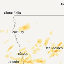
Iowa
| Local Time | Report Details |
|---|---|
| 12:24 PM UTC | Quarter sized hail reported near West des Moines, IA, 7.1 miles W of Des Moines, IA |
| 12:30 PM UTC | Quarter sized hail reported near West des Moines, IA, 7.5 miles W of Des Moines, IA, observed at woi tv abc5 studios in west des moines |
| 7:32 AM CDT | Half Dollar sized hail reported near Des Moines, IA, 0.7 miles SSW of Des Moines, IA, intersection of hickman road and beaver avenue in beaverdale. |
| 12:42 PM UTC | Quarter sized hail reported near West des Moines, IA, 9.1 miles W of Des Moines, IA |
| 9:20 AM CDT | Ping Pong Ball sized hail reported near Clive, IA, 7.1 miles WNW of Des Moines, IA, went out after the hail ended and measured up to ping pong sized hail. |
| 2:23 PM UTC | Quarter sized hail reported near West des Moines, IA, 7.5 miles W of Des Moines, IA, at woi-tv |
| 9:30 AM CDT | Golf Ball sized hail reported near Des Moines, IA, 4.2 miles NNW of Des Moines, IA, 30th and aurora |
| 2:32 PM UTC | Quarter sized hail reported near Des Moines, IA, 3.5 miles N of Des Moines, IA |
| 9:32 AM CDT | Golf Ball sized hail reported near Urbandale, IA, 7.3 miles WNW of Des Moines, IA, mainly nickel and quarter hail with a few the size of golfballs at the urbandale golf and country club |
| 9:35 AM CDT | Quarter sized hail reported near Des Moines, IA, 0.7 miles SSW of Des Moines, IA |
| 9:36 AM CDT | Golf Ball sized hail reported near Des Moines, IA, 0.7 miles SSW of Des Moines, IA, intersection of 12th and shawnee in the highland park area. |
| 2:45 PM UTC | Quarter sized hail reported near Persia, IA, 26.1 miles NNE of Omaha, NE |
| 4:40 PM UTC | Quarter sized hail reported near Malvern, IA, 30.2 miles SE of Omaha, NE, also 1.30 inches of rain. time estimated. |
| 9:50 PM UTC | Quarter sized hail reported near Bloomfield, IA, 46.2 miles WNW of Kahoka, MO |
| 10:11 PM UTC | Quarter sized hail reported near Marcus, IA, 33.2 miles WNW of Storm Lake, IA |
| 10:45 PM UTC | Trees and power lines dow in clay county IA, 25 miles N of Storm Lake, IA |
| 10:50 PM UTC | Semi trailer blown over. also report trees and power lines down in greenvill in clay county IA, 22.4 miles N of Storm Lake, IA |
| 11:12 PM UTC | Trees down south of ayshire on 380th ave...at 430st and 460st...time estimated from radar in palo alto county IA, 30.8 miles NE of Storm Lake, IA |
| 12:10 AM UTC | Downed tree in the city blocking a road. tree diameter of 2 ft. time estimated from rada in kossuth county IA, 52.3 miles W of Mason City, IA |
| 1:18 AM UTC | Half Dollar sized hail reported near Des Moines, IA, 4.7 miles SSW of Des Moines, IA, 1.25 inch hail at airport |
| 1:23 AM UTC | Ping Pong Ball sized hail reported near Des Moines, IA, 5.8 miles SSW of Des Moines, IA |
| 8:25 PM CDT | Quarter sized hail reported near Des Moines, IA, 0.7 miles SSW of Des Moines, IA |
| 1:26 AM UTC | Golf Ball sized hail reported near Des Moines, IA, 3.5 miles ENE of Des Moines, IA |
| 1:35 AM UTC | Quarter sized hail reported near Des Moines, IA, 2.8 miles NE of Des Moines, IA |
| 8:45 PM CDT | Golf Ball sized hail reported near Pleasant Hill, IA, 5.5 miles E of Des Moines, IA, relayed by dsmweather.com |
| 1:55 AM UTC | Quarter sized hail reported near Ames, IA, 27.6 miles N of Des Moines, IA |
| 2:10 AM UTC | Golf Ball sized hail reported near State Center, IA, 37.6 miles NE of Des Moines, IA |
| 2:11 AM UTC | Golf Ball sized hail reported near State Center, IA, 37.6 miles NE of Des Moines, IA |
| 2:17 AM UTC | Ping Pong Ball sized hail reported near Ankeny, IA, 9.8 miles N of Des Moines, IA, average hail size 1.25 inch diameter. minor leaf damage to trees. |
| 2:19 AM UTC | Quarter sized hail reported near Ankeny, IA, 9 miles N of Des Moines, IA |
| 2:20 AM UTC | Quarter sized hail reported near Ankeny, IA, 9 miles N of Des Moines, IA |
| 2:22 AM UTC | Half Dollar sized hail reported near Ankeny, IA, 9 miles N of Des Moines, IA |
| 2:23 AM UTC | Quarter sized hail reported near Ankeny, IA, 12 miles NNE of Des Moines, IA |
| 2:24 AM UTC | Golf Ball sized hail reported near Ankeny, IA, 9 miles N of Des Moines, IA |
| 2:45 AM UTC | 3 ft diameter tree down across road. time estimated from rada in story county IA, 40.5 miles N of Des Moines, IA |
| 3:15 AM UTC | Quarter sized hail reported near Indianola, IA, 16 miles S of Des Moines, IA |
| 3:16 AM UTC | Quarter sized hail reported near Indianola, IA, 16 miles S of Des Moines, IA |
| 3:17 AM UTC | Half Dollar sized hail reported near Indianola, IA, 14.5 miles S of Des Moines, IA, mostly half dollar sized hail with one golf ball sized stone. |
| 3:18 AM UTC | Half Dollar sized hail reported near Indianola, IA, 14.7 miles SSE of Des Moines, IA, quarter to 1/2 dollar size hail |
| 3:31 AM UTC | Quarter sized hail reported near Braddyville, IA, 66.5 miles SE of Omaha, NE |
| 3:33 AM UTC | Tossed a burn barrel across the yar in mills county IA, 17.1 miles SSE of Omaha, NE |
| 3:52 AM UTC | Quarter sized hail reported near Pleasantville, IA, 22.6 miles SE of Des Moines, IA |
| 3:56 AM UTC | Quarter sized hail reported near Pleasantville, IA, 22.6 miles SE of Des Moines, IA, public also reported heavy rainfall...coming down in sheets. |
| 4:00 AM UTC | Estimated 55-60 mph winds. also 2 inches of rain overnigh in mills county IA, 28.4 miles SE of Omaha, NE |
| 4:15 AM UTC | Gusts at least 60 mph. some pea sized hai in pottawattamie county IA, 27.1 miles E of Omaha, NE |
| 4:15 AM UTC | 2-3 inch limbs dow in pottawattamie county IA, 27.1 miles E of Omaha, NE |
| 4:40 AM UTC | Quarter sized hail reported near Malvern, IA, 30.2 miles SE of Omaha, NE, also 1.30 inches of rain. time estimated. |
Vermont
| Local Time | Report Details |
|---|---|
| 1:07 PM UTC | Quarter sized hail reported near Killington, VT, 61.4 miles SSE of Burlington, VT, quarter-sized hail |
| 1:07 PM UTC | Quarter sized hail reported near Killington, VT, 62.1 miles SSE of Burlington, VT, tree limbs down as well. |
| 5:20 PM UTC | Numerous trees and power lines down in rutland county VT, 60.9 miles S of Burlington, VT |
| 5:42 PM UTC | Trees down blocking post office hill road in addison county VT, 38.7 miles SSE of Burlington, VT |
| 5:54 PM UTC | Trees down blocking crocker road in orange county VT, 46.4 miles SE of Burlington, VT |
| 6:03 PM UTC | Trees down blocking crocker road in orange county VT, 46.4 miles SE of Burlington, VT |
| 6:05 PM UTC | Tree down on i-89 south in chittenden county VT, 2.3 miles ENE of Burlington, VT |
| 6:14 PM UTC | Quarter sized hail reported near Proctor, VT, 57 miles S of Burlington, VT, quarter-sized hail |
| 6:20 PM UTC | Numerous trees and power lines down in rutland county VT, 60.9 miles S of Burlington, VT |
| 6:30 PM UTC | Numerous trees down in orange county VT, 66.1 miles SE of Burlington, VT |
| 6:30 PM UTC | Multiple reports of trees down blocking roads in orange county VT, 58.9 miles SE of Burlington, VT |
| 6:30 PM UTC | Numerous trees down in thetford in orange county VT, 65.4 miles SE of Burlington, VT |
| 6:48 PM UTC | Weathernet 6 - trees and powerlines down in bennington county VT, 61.8 miles ENE of Schenectady, NY |
| 7:00 PM UTC | Storm damage reported in windsor county VT, 79.7 miles SSE of Burlington, VT |
| 7:17 PM UTC | Trees and wires down in windham county VT, 60.5 miles ENE of Schenectady, NY |
Connecticut
| Local Time | Report Details |
|---|---|
| 1:49 PM UTC | Quarter sized hail reported near North Canaan, CT, 62.4 miles SSE of Schenectady, NY |
| 8:13 PM UTC | Golf Ball sized hail reported near Norfolk, CT, 68.3 miles SE of Schenectady, NY |
| 8:30 PM UTC | Ping Pong Ball sized hail reported near Torrington, CT, 79.5 miles SSE of Schenectady, NY |
| 8:30 PM UTC | Trees and wires down on rt 183. road blocke in litchfield county CT, 75.5 miles SE of Schenectady, NY |
| 8:33 PM UTC | Ping Pong Ball sized hail reported near Winchester, CT, 75.5 miles SE of Schenectady, NY |
| 8:35 PM UTC | Tree down on house in litchfield county CT, 68.9 miles NNE of Brooklyn, NY |
| 8:40 PM UTC | Tree down across rt 202 in litchfield county CT, 75.9 miles NNE of Brooklyn, NY |
| 8:45 PM UTC | Trees down across rt 20 in litchfield county CT, 83.4 miles SSE of Schenectady, NY |
| 8:45 PM UTC | Half Dollar sized hail reported near Winchester, CT, 75.1 miles SSE of Schenectady, NY |
| 8:50 PM UTC | Trees down in litchfield county CT, 75.1 miles SSE of Schenectady, NY |
| 8:53 PM UTC | Ping Pong Ball sized hail reported near Norfolk, CT, 68.3 miles SE of Schenectady, NY |
| 8:57 PM UTC | Large tree down on route 7 just north of 202. road close in fairfield county CT, 62.2 miles NNE of Brooklyn, NY |
| 8:58 PM UTC | Trees down in litchfield county CT, 79.5 miles SSE of Schenectady, NY |
| 9:00 PM UTC | Trees down in litchfield county CT, 71.3 miles NE of Brooklyn, NY |
| 9:00 PM UTC | Quarter sized hail reported near Torrington, CT, 79.7 miles SE of Schenectady, NY |
| 9:05 PM UTC | Tree on car on orlando dr in hartford county CT, 60.6 miles W of Providence, RI |
| 9:05 PM UTC | Tree on roof on green valley dr in hartford county CT, 60.6 miles W of Providence, RI |
| 9:07 PM UTC | Quarter sized hail reported near Winchester, CT, 75.5 miles SE of Schenectady, NY |
| 9:07 PM UTC | Down trees in litchfield county CT, 62.4 miles SSE of Schenectady, NY |
| 9:16 PM UTC | Dozens of trees down across pumpkin hill r in litchfield county CT, 68.9 miles NNE of Brooklyn, NY |
| 9:20 PM UTC | Trees and wires down in litchfield county CT, 68.9 miles NNE of Brooklyn, NY |
| 9:25 PM UTC | Tree down on south meriden street. road close in new haven county CT, 79.7 miles NE of Brooklyn, NY |
| 9:30 PM UTC | Storm damage reported in new haven county CT, 75.8 miles NE of Brooklyn, NY |
| 10:05 PM UTC | Small trees down in new haven county CT, 75.8 miles NE of Brooklyn, NY |
| 10:15 PM UTC | Trees down across town in fairfield county CT, 53.1 miles NE of Brooklyn, NY |
Missouri
| Local Time | Report Details |
|---|---|
| 1:58 PM UTC | Tea Cup sized hail reported near Rothville, MO, 61.9 miles NW of Columbia, MO, 2 1/2 to 3 inch hail. |
| 8:12 PM UTC | Quarter sized hail reported near La Plata, MO, 58.4 miles WSW of Kahoka, MO |
| 8:28 PM UTC | Ping Pong Ball sized hail reported near Atlanta, MO, 55.9 miles SW of Kahoka, MO |
| 8:32 PM UTC | Quarter sized hail reported near La Plata, MO, 48.9 miles WSW of Kahoka, MO |
| 8:36 PM UTC | Gas station sign damaged. time estiamted from rada in macon county MO, 48.9 miles WSW of Kahoka, MO |
| 8:38 PM UTC | Quarter sized hail reported near La Plata, MO, 46.8 miles WSW of Kahoka, MO, also estimated 55 mph winds |
| 9:05 PM UTC | Baseball sized hail reported near Atlanta, MO, 52.2 miles SW of Kahoka, MO, numerous reports from media |
| 10:30 PM UTC | Quarter sized hail reported near Jamesport, MO, 73 miles NE of Kansas City, MO |
| 10:44 PM UTC | Quarter sized hail reported near Jamesport, MO, 73 miles NE of Kansas City, MO |
| 10:57 PM UTC | Golf Ball sized hail reported near Trenton, MO, 79.5 miles NE of Kansas City, MO |
| 11:00 PM UTC | Baseball sized hail reported near Trenton, MO, 80.4 miles NE of Kansas City, MO |
| 11:06 PM UTC | Half Dollar sized hail reported near Hannibal, MO, 50.5 miles SSE of Kahoka, MO, hail lasted 5 minutes. |
| 11:07 PM UTC | Ping Pong Ball sized hail reported near New London, MO, 54.4 miles SSE of Kahoka, MO |
| 11:09 PM UTC | Quarter sized hail reported near Hannibal, MO, 53.5 miles SSE of Kahoka, MO |
| 11:10 PM UTC | Billboards down on us 6 in ralls county MO, 54.2 miles SSE of Kahoka, MO |
| 11:10 PM UTC | Trees blown down and blocking highway hh east southeast of rensselae in ralls county MO, 54 miles SSE of Kahoka, MO |
| 11:10 PM UTC | 54000 block of highway m reported north side of a 200 x 60 shed has been damaged. approximately 30-40 feet of the north side of the metal structure has been torn of in ralls county MO, 56.8 miles SSE of Kahoka, MO |
| 11:10 PM UTC | 4 foot diamter tree down on paris gravel roa in marion county MO, 51.2 miles SSE of Kahoka, MO |
| 11:10 PM UTC | Garage blown down from a residenc in ralls county MO, 54.3 miles SSE of Kahoka, MO |
| 11:10 PM UTC | 54000 block of highway m reported north side of a 200 x 60 shed has been damaged. approximately 30-40 feet of the north side of the metal structure has been torn of in ralls county MO, 54.1 miles SSE of Kahoka, MO |
| 11:12 PM UTC | Quarter sized hail reported near Hannibal, MO, 52.1 miles SSE of Kahoka, MO, at the intersection of u.s. highway 61 and west ely road. |
| 11:13 PM UTC | Shingles blown off roof in ralls county MO, 54.3 miles S of Kahoka, MO |
| 11:13 PM UTC | Numerous roofs blown off houses on 1100 block of stable driv in ralls county MO, 55.5 miles SSE of Kahoka, MO |
| 11:13 PM UTC | Power is out due to the thunderstorm wind in ralls county MO, 55.7 miles SSE of Kahoka, MO |
| 11:16 PM UTC | Relayed by marion county 991 call cente in ralls county MO, 53.5 miles SSE of Kahoka, MO |
| 11:18 PM UTC | 50 to 60 mph estimated wind in ralls county MO, 58.5 miles SSE of Kahoka, MO |
| 11:19 PM UTC | Up to 5 inch limbs snapped off trees... up to 8 inch diameter pine trees snapped off at the base... trees downed on the road near intersection of highways 61 and m in ralls county MO, 57.1 miles SSE of Kahoka, MO |
| 11:20 PM UTC | Estimated 70 mph wind just south of hannibal missouri near highway 61. 2 foot diameter tree uproote in marion county MO, 52.2 miles SSE of Kahoka, MO |
| 11:20 PM UTC | Estimated 70 to 80 mph wind in ralls county MO, 58.5 miles SSE of Kahoka, MO |
| 11:21 PM UTC | Half Dollar sized hail reported near Trenton, MO, 85.4 miles NE of Kansas City, MO |
| 11:22 PM UTC | 4 foot diamter tree down on paris gravel roa in marion county MO, 51.2 miles SSE of Kahoka, MO |
| 11:32 PM UTC | Tennis Ball sized hail reported near Trenton, MO, 85.4 miles NE of Kansas City, MO |
| 11:37 PM UTC | Golf Ball sized hail reported near Gallatin, MO, 62.8 miles NNE of Kansas City, MO |
| 11:45 PM UTC | Quarter sized hail reported near Barnard, MO, 73.8 miles NNW of Kansas City, MO |
| 11:52 PM UTC | Part of tree blown down in grundy county MO, 80.1 miles NE of Kansas City, MO |
| 12:01 AM UTC | Quarter sized hail reported near Bevier, MO, 56.4 miles NNW of Columbia, MO |
| 12:05 AM UTC | Hen Egg sized hail reported near Callao, MO, 53.2 miles NNW of Columbia, MO |
| 12:15 AM UTC | Half Dollar sized hail reported near Conception, MO, 79.3 miles N of Kansas City, MO |
| 12:15 AM UTC | Half Dollar sized hail reported near Conception Junction, MO, 80 miles N of Kansas City, MO |
| 12:15 AM UTC | Ping Pong Ball sized hail reported near Callao, MO, 57.8 miles NNW of Columbia, MO |
| 12:16 AM UTC | Golf Ball sized hail reported near Humphreys, MO, 86.9 miles WSW of Kahoka, MO |
| 12:17 AM UTC | Quarter sized hail reported near Stanberry, MO, 79.3 miles N of Kansas City, MO |
| 12:20 AM UTC | Ping Pong Ball sized hail reported near Stanberry, MO, 77.1 miles N of Kansas City, MO |
| 12:20 AM UTC | Ping Pong Ball sized hail reported near Stanberry, MO, 80.5 miles N of Kansas City, MO |
| 12:25 AM UTC | Quarter sized hail reported near Altamont, MO, 60.4 miles NNE of Kansas City, MO |
| 12:30 AM UTC | Half Dollar sized hail reported near Pattonsburg, MO, 69.5 miles NNE of Kansas City, MO |
| 12:50 AM UTC | Half Dollar sized hail reported near Linneus, MO, 84.2 miles NW of Columbia, MO |
| 12:58 AM UTC | Tennis Ball sized hail reported near Gallatin, MO, 65.4 miles NNE of Kansas City, MO |
| 1:02 AM UTC | Tea Cup sized hail reported near Lock Springs, MO, 70.1 miles NE of Kansas City, MO |
| 1:05 AM UTC | Baseball sized hail reported near Jamesport, MO, 73 miles NE of Kansas City, MO |
| 1:11 AM UTC | Ping Pong Ball sized hail reported near Jameson, MO, 70.1 miles NNE of Kansas City, MO |
| 1:23 AM UTC | Golf Ball sized hail reported near Trenton, MO, 79.5 miles NE of Kansas City, MO |
| 1:38 AM UTC | Half Dollar sized hail reported near Milan, MO, 78 miles WSW of Kahoka, MO |
| 1:58 AM UTC | Tea Cup sized hail reported near Rothville, MO, 61.9 miles NW of Columbia, MO, 2 1/2 to 3 inch hail. |
| 2:07 AM UTC | Tennis Ball sized hail reported near Rothville, MO, 64.7 miles NW of Columbia, MO |
| 2:13 AM UTC | Quarter sized hail reported near Marceline, MO, 62.4 miles NNW of Columbia, MO |
| 2:30 AM UTC | Baseball sized hail reported near Bucklin, MO, 64.4 miles NNW of Columbia, MO |
| 2:34 AM UTC | Golf Ball sized hail reported near Brookfield, MO, 68.3 miles NNW of Columbia, MO |
| 2:41 AM UTC | Golf Ball sized hail reported near New Cambria, MO, 63.2 miles NNW of Columbia, MO |
| 3:43 AM UTC | Golf Ball sized hail reported near New Cambria, MO, 63.2 miles NNW of Columbia, MO |
| 3:56 AM UTC | Storm damage reported in macon county MO, 68.8 miles WSW of Kahoka, MO |
North Carolina
| Local Time | Report Details |
|---|---|
| 5:00 PM UTC | Several trees down in surry county NC, 66.3 miles SW of Roanoke, VA |
| 5:00 PM UTC | Several trees down in surry county NC, 61.4 miles SSW of Roanoke, VA |
| 5:10 PM UTC | Quarter sized hail reported near , , 31.1 miles NW of Greenville, SC, heavy dime to nickel size hail with some quarter size hail. fox run rid |
| 5:27 PM UTC | Two large maple trees blown down on summit roa in wilkes county NC, 51.3 miles ESE of Bristol, TN |
| 5:32 PM UTC | One tree down. fell on power line. fire department calle in surry county NC, 66.3 miles SW of Roanoke, VA |
| 5:32 PM UTC | One tree down in westfield. fell on power line. fire department calle in surry county NC, 61.4 miles SSW of Roanoke, VA |
| 5:36 PM UTC | A few trees down about a mile from the wilson creek visitors center and even more trees down toward table rock mountai in caldwell county NC, 50 miles SSE of Bristol, TN |
| 6:03 PM UTC | Quarter sized hail reported near Highlands, NC, 36.7 miles WNW of Greenville, SC, quarter size hail on wahalla rd approx 2.5 miles south of highlands. |
| 6:25 PM UTC | Quarter sized hail reported near Marion, NC, 60.6 miles S of Bristol, TN, dime to quarter sized hail fell at the lake tohoma dam. |
| 6:30 PM UTC | Quarter sized hail reported near Hendersonville, NC, 32.9 miles N of Greenville, SC, dispatcher reported having nickel to quarter sized hail at their residence yesterday afternoon near the valley hill fire department. |
| 2:35 PM EDT | Quarter sized hail reported near Blowing Rock, NC, 44.7 miles SE of Bristol, TN |
| 6:40 PM UTC | Several trees down around marion. at least one down on residence on lena st. carport flipped over on nix creek r in mcdowell county NC, 64 miles S of Bristol, TN |
| 6:44 PM UTC | A few trees were blown down near downtown asheville. one tree landed on a house...but only minor structural damag in buncombe county NC, 51 miles N of Greenville, SC |
| 6:48 PM UTC | Quarter sized hail reported near Asheville, NC, 51 miles N of Greenville, SC, trained spotter reported quarter size hail on i-240 at tunnel rd. |
| 7:00 PM UTC | Several trees down in yadkin county NC, 60.7 miles N of Charlotte, NC |
| 7:04 PM UTC | Quarter sized hail reported near Burlington, NC, 48.3 miles NW of Raleigh, NC, quarter inch hail |
| 7:10 PM UTC | 911 comm reports multiple trees and powerlines down in the northwest part of downtown hickor in catawba county NC, 45.2 miles NW of Charlotte, NC |
| 7:10 PM UTC | Tree down on sarah lee rd. hail of unknown size in area. lightning struck an outbuilding and set it on fire. another tree down in union mill in rutherford county NC, 53.3 miles NNE of Greenville, SC |
| 7:30 PM UTC | Quarter sized hail reported near Clemmons, NC, 61.8 miles NNE of Charlotte, NC, quarter sized hail was reported along south stratford road near winterberry road. |
| 7:40 PM UTC | Two trees down in rutherfordton area. one on darlington rd and one on oak st. other trees down across count in rutherford county NC, 51.4 miles NE of Greenville, SC |
| 7:42 PM UTC | Trees and power lines were reported down along horneytown road near panther ridge roa in davidson county NC, 69.2 miles NE of Charlotte, NC |
| 7:50 PM UTC | Quarter sized hail reported near Vale, NC, 40.9 miles WNW of Charlotte, NC, 911 comm via police officer reports quarter size hail in the northwest part of lincoln c |
| 7:58 PM UTC | One tree was reported down along hinkle lane near old u.s. hwy 5 in davidson county NC, 57.8 miles NE of Charlotte, NC |
| 8:01 PM UTC | Quarter sized hail reported near Cherryville, NC, 39.9 miles WNW of Charlotte, NC, quarter hail with large limbs down. flag pole bent in half nearby. |
| 8:05 PM UTC | Quarter sized hail reported near Brevard, NC, 29.1 miles NNW of Greenville, SC, dime to quarter sized hail fell for a short time in brevard. do not know of any wind damage. |
| 8:10 PM UTC | Quarter sized hail reported near Charlotte, NC, 4.1 miles SSW of Charlotte, NC, quarter sized hail on south blvd. |
| 4:17 PM EDT | Ping Pong Ball sized hail reported near Browns Summit, NC, 69.8 miles WNW of Raleigh, NC, generally half to three quarters inch hail with larger stones measuring one and one half inch |
| 8:20 PM UTC | Quarter sized hail reported near Browns Summit, NC, 70.3 miles WNW of Raleigh, NC |
| 8:25 PM UTC | Few trees down in cherokee county NC, 58.9 miles E of Chattanooga, TN |
| 8:26 PM UTC | Quarter sized hail reported near Browns Summit, NC, 70.3 miles WNW of Raleigh, NC, nickel to quarter sized hail |
| 8:28 PM UTC | Quarter sized hail reported near Browns Summit, NC, 69 miles WNW of Raleigh, NC, quarter sized hail |
| 8:35 PM UTC | Quarter sized hail reported near Marshall, NC, 60.3 miles SSW of Bristol, TN, report of quarter size hail in ne marshall. |
| 4:35 PM EDT | Half Dollar sized hail reported near Browns Summit, NC, 69.8 miles WNW of Raleigh, NC, quarter to half dollar sized hail started around 417 pm and lasted until 435 pm in the browns summit area. |
| 8:36 PM UTC | A couple of trees down in shelby vicinity with the stor in cleveland county NC, 40 miles W of Charlotte, NC |
| 4:40 PM EDT | A few trees down around huntersville in mecklenburg county NC, 13.6 miles N of Charlotte, NC |
| 8:44 PM UTC | Quarter sized hail reported near Reidsville, NC, 65.3 miles SSE of Roanoke, VA |
| 8:48 PM UTC | Golf Ball sized hail reported near Hayesville, NC, 61.3 miles S of Knoxville, TN, golf ball size hail |
| 8:58 PM UTC | Half Dollar sized hail reported near Mint Hill, NC, 10.4 miles ESE of Charlotte, NC, most of the hail was dime to quarter sized...but a few pieces of hail was as large as a half dollar. the police department in mint hill also reported dime sized hail. t |
| 9:15 PM UTC | A spotter who is also a fire fighter reported several trees down near iron mountain on the mitchell county and tennessee borde in mitchell county NC, 30.5 miles S of Bristol, TN |
| 9:15 PM UTC | Large tree uprooted and ready to fall on route 770 near the plastics plant in rockingham county NC, 53.1 miles SSE of Roanoke, VA |
| 5:16 PM EDT | Numerous tree limbs blown down in mecklenburg county NC, 13.6 miles N of Charlotte, NC |
| 9:20 PM UTC | Quarter sized hail reported near Bakersville, NC, 32.6 miles S of Bristol, TN, a relative of a spotter said hail was around the size of a quarter and fell for a short time. |
| 9:20 PM UTC | Quarter sized hail reported near Salisbury, NC, 33.9 miles NNE of Charlotte, NC, a few waves of brief hail for about 5 minutes...but largest around quarter sized. ended around 525 pm. strong smell of pine in the air after storm. |
| 10:00 PM UTC | Trees blown down in yancey county NC, 48.6 miles SSW of Bristol, TN |
| 10:08 PM UTC | Large tree pushed over. time estimate in vance county NC, 48.9 miles NNE of Raleigh, NC |
| 10:25 PM UTC | Three trees across hibernia road. time estimate in vance county NC, 52.1 miles NNE of Raleigh, NC |
| 6:40 PM EDT | A few trees down around huntersville in mecklenburg county NC, 13.6 miles N of Charlotte, NC |
| 1:42 AM UTC | Measured on a home weather statio in cabarrus county NC, 16.6 miles NE of Charlotte, NC |
| 1:50 AM UTC | A tree fell on a mobile home and roof damage at a manufacturing facility. both occurred about the same tim in rowan county NC, 36.9 miles NNE of Charlotte, NC |
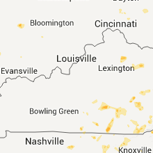
Kentucky
| Local Time | Report Details |
|---|---|
| 5:07 PM UTC | Over two dozen trees down along and off of crane creek roa in clay county KY, 29.9 miles SSE of Irvine, KY |
| 5:28 PM UTC | Tree down in oneid in clay county KY, 34.6 miles SSE of Irvine, KY |
| 7:00 PM UTC | Trees and a cable line down in bethel. also...dime sized hail covered the ground and the temperature dropped from 90 degrees to 60 degrees in a short tim in bath county KY, 38.4 miles N of Irvine, KY |
| 7:10 PM UTC | Trees down in parmleysville. also half inch size hail and torrential rai in wayne county KY, 67.8 miles NW of Knoxville, TN |
| 7:17 PM UTC | Tree and large tree limbs dow in bell county KY, 46.2 miles NNE of Knoxville, TN |
| 7:55 PM UTC | Tree downed across highway 91 in casey county KY, 63.9 miles WSW of Irvine, KY |
| 8:35 PM UTC | Trees and power lines were reported near draffin and millar in pike county KY, 52.2 miles N of Bristol, TN |
| 8:48 PM UTC | Quarter sized hail reported near Shelbiana, KY, 59.7 miles NNW of Bristol, TN |
| 8:58 PM UTC | Ping Pong Ball sized hail reported near McKee, KY, 15.9 miles S of Irvine, KY |
| 9:03 PM UTC | Quarter sized hail reported near McKee, KY, 16.8 miles S of Irvine, KY |
| 9:15 PM UTC | Quarter sized hail reported near Ulysses, KY, 64.3 miles WSW of Charleston, WV |
| 9:22 PM UTC | Golf Ball sized hail reported near Keaton, KY, 58.8 miles ENE of Irvine, KY |
| 9:41 PM UTC | 6-7 trees down on highway 1812 between mile marker 6 and in breathitt county KY, 34.3 miles E of Irvine, KY |
| 10:12 PM UTC | Quarter sized hail reported near Oil Springs, KY, 57.2 miles E of Irvine, KY, largest stones were about 1 inch |
| 10:28 PM UTC | 1 tree down on highway 1098 between mile marker 1 and 2 at south for in breathitt county KY, 37.3 miles ESE of Irvine, KY |
| 11:00 PM UTC | Trees and cable line down in bethel. also dime sized hail covered the ground and the temperature went from 90 to 60 degrees in a short tim in bath county KY, 38.4 miles N of Irvine, KY |
| 11:55 PM UTC | Amateur radio antenna tower blown down. tree limbs down. gust to 64 mph measured on personal weather station in are in mccracken county KY, 59.8 miles N of Mc Kenzie, TN |
| 12:50 AM UTC | Quarter sized hail reported near Flemingsburg, KY, 41.7 miles NNE of Irvine, KY, trained spotter reported quarter to pea sized hail. |
| 12:57 AM UTC | Half Dollar sized hail reported near Owingsville, KY, 41 miles NNE of Irvine, KY |
| 1:28 AM UTC | Ping Pong Ball sized hail reported near McKee, KY, 15.9 miles S of Irvine, KY |
Tennessee
| Local Time | Report Details |
|---|---|
| 5:40 PM UTC | Quarter sized hail reported near Jacksboro, TN, 29.6 miles NNW of Knoxville, TN, quarter size hail |
| 7:28 PM UTC | A few trees down along highway 307 in mcminn county TN, 46.3 miles SW of Knoxville, TN |
| 8:45 PM UTC | Several trees down on power and lines and vehicle in sullivan county TN, 19.3 miles WSW of Bristol, TN |
| 11:55 PM UTC | Several trees down in hamilton county TN, 16.7 miles NNE of Chattanooga, TN |
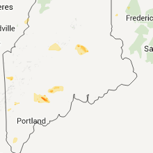
Maine
| Local Time | Report Details |
|---|---|
| 6:00 PM UTC | Trees and power lines down resulting in power otuages. time is estimated in piscataquis county ME, 44.7 miles NNW of Bangor, ME |
| 6:03 PM UTC | Storm damage reported in piscataquis county ME, 36.6 miles NNW of Bangor, ME |
| 6:05 PM UTC | Tress down around high street and church stree in piscataquis county ME, 37.3 miles NNW of Bangor, ME |
| 6:12 PM UTC | Trees and power lines down. time is estimate in piscataquis county ME, 38.8 miles NNW of Bangor, ME |
| 6:20 PM UTC | Tree limb approximately 2 ft around down across power lin in piscataquis county ME, 32.8 miles NNW of Bangor, ME |
| 6:24 PM UTC | Numerous tree limbs down across power lines in piscataquis county ME, 38.8 miles NNW of Bangor, ME |
| 6:24 PM UTC | Numerous tree limbs down across power lines in piscataquis county ME, 32.8 miles NNW of Bangor, ME |
| 7:30 PM UTC | Quarter sized hail reported near Fort Fairfield, ME, 11.1 miles ESE of Caribou, ME |
| 7:40 PM UTC | Branches on rt 5 east of fryeburg in oxford county ME, 43.9 miles NW of Portland, ME |
| 8:15 PM UTC | Trees down on about 6 inches across. gravel and dirt across roa in aroostook county ME, 8.1 miles SE of Caribou, ME |
| 8:18 PM UTC | Tree down on bear pond road. power ou in oxford county ME, 42.2 miles NNW of Portland, ME |
| 8:20 PM UTC | Multiple branches and trees down in york county ME, 22.2 miles SW of Portland, ME |
| 8:30 PM UTC | Quarter sized hail reported near Fort Fairfield, ME, 11.1 miles ESE of Caribou, ME |
| 8:30 PM UTC | Trees down on rt 135 west of belgrade in kennebec county ME, 57.6 miles WSW of Bangor, ME |
| 8:30 PM UTC | Trees down on route 1a between fort fairfield and limestone in aroostook county ME, 9 miles ESE of Caribou, ME |
| 8:38 PM UTC | Branches down at sanford airport in york county ME, 28.6 miles SW of Portland, ME |
| 8:38 PM UTC | Tree down at walmart in sanford in york county ME, 29.4 miles SW of Portland, ME |
| 8:40 PM UTC | Large trees down on private property in york county ME, 22.2 miles SW of Portland, ME |
| 8:55 PM UTC | Trees down on camper in somerset county ME, 95.2 miles NW of Bangor, ME |
| 9:00 PM UTC | Trees down reported by augusta police in kennebec county ME, 49.4 miles NNE of Portland, ME |
| 9:00 PM UTC | Tennis Ball sized hail reported near Hallowell, ME, 49.4 miles NNE of Portland, ME, metal roof damaged |
| 9:05 PM UTC | Trees and wires down on sandy beach rd in androscoggin county ME, 30.5 miles N of Portland, ME |
| 9:05 PM UTC | Tree on house on webster st in androscoggin county ME, 30.5 miles N of Portland, ME |
| 9:05 PM UTC | Wires down on college st in androscoggin county ME, 30.5 miles N of Portland, ME |
| 9:05 PM UTC | Wind brought down large limb in androscoggin county ME, 31.1 miles N of Portland, ME |
| 9:10 PM UTC | Multiple trees down in kennebec county ME, 46 miles NNE of Portland, ME |
| 9:10 PM UTC | Quarter sized hail reported near Randolph, ME, 46.6 miles NNE of Portland, ME |
| 9:15 PM UTC | Trees and wires down clossen s in kennebec county ME, 46.3 miles NNE of Portland, ME |
| 9:18 PM UTC | Quarter sized hail reported near Winslow, ME, 40.5 miles WSW of Bangor, ME |
| 9:20 PM UTC | Trees down on almar near par in kennebec county ME, 46.9 miles NNE of Portland, ME |
| 9:20 PM UTC | Trees and wires down on north s in kennebec county ME, 46 miles NNE of Portland, ME |
| 10:00 PM UTC | Numerous trees down ne of katahdin iron works. time is estimate in piscataquis county ME, 49.9 miles NNW of Bangor, ME |
| 10:15 PM UTC | Tree down pond rd in kennebec county ME, 46.3 miles NNE of Portland, ME |
| 10:30 PM UTC | Large tree down on a house in lincol in penobscot county ME, 40.6 miles NNE of Bangor, ME |
| 10:30 PM UTC | Numerous trees down in lincol in penobscot county ME, 40.6 miles NNE of Bangor, ME |
| 10:30 PM UTC | Numerous trees down. two garage doors blown off a metal storage building in penobscot county ME, 40.6 miles NNE of Bangor, ME |
| 10:30 PM UTC | Two garage doors blown off a metal storage building in penobscot county ME, 40.6 miles NNE of Bangor, ME |
| 10:30 PM UTC | Quarter sized hail reported near Lincoln, ME, 40.6 miles NNE of Bangor, ME |
Pennsylvania
| Local Time | Report Details |
|---|---|
| 6:25 PM UTC | Quarter sized hail reported near Chatham, PA, 75.6 miles NNE of State College, PA |
| 6:42 PM UTC | Quarter sized hail reported near Little Meadows, PA, 46.8 miles NNW of Scranton, PA, cloud 9 covers business |
| 6:50 PM UTC | Quarter sized hail reported near Warren, PA, 44.5 miles NW of Scranton, PA |
| 7:00 PM UTC | Quarter sized hail reported near Towanda, PA, 47.8 miles WNW of Scranton, PA |
| 7:10 PM UTC | Golf Ball sized hail reported near Clymer, PA, 54.4 miles ENE of Pittsburgh, PA |
| 7:30 PM UTC | Quarter sized hail reported near Montrose, PA, 31.1 miles NNW of Scranton, PA |
| 7:38 PM UTC | Quarter sized hail reported near Jackson, PA, 58.6 miles WSW of State College, PA, quarter-sized hail reported along with wind gusts to near 50 mph. |
| 7:55 PM UTC | Trees reported down in mount pleasant in westmoreland county PA, 31.3 miles SE of Pittsburgh, PA |
| 7:58 PM UTC | Quarter sized hail reported near Ligonier, PA, 42.3 miles ESE of Pittsburgh, PA, event occurred between 343 pm 06 09 2011 and 358 pm 06 09 2011 |
| 8:10 PM UTC | Trees down in wyoming county. large power outage in the tunkhannock are in wyoming county PA, 17.5 miles WNW of Scranton, PA |
| 4:20 PM EDT | Quarter sized hail reported near Ligonier, PA, 45 miles ESE of Pittsburgh, PA |
| 4:35 PM EDT | Golf Ball sized hail reported near Jermyn, PA, 10.1 miles NE of Scranton, PA |
| 9:00 PM UTC | Medium size tree down estimated wind gust 60 mph in luzerne county PA, 13.7 miles WSW of Scranton, PA |
| 9:10 PM UTC | Trees reported dow in lycoming county PA, 50.2 miles ENE of State College, PA |
| 9:15 PM UTC | Trees reported down in munc in lycoming county PA, 60.5 miles WSW of Scranton, PA |
| 9:15 PM UTC | Trees and wires down along route 405 between muncy and hughesvill in lycoming county PA, 58.2 miles WSW of Scranton, PA |
| 9:18 PM UTC | Quarter sized hail reported near Chestnut Hill, PA, 35.7 miles SSE of Scranton, PA |
| 9:18 PM UTC | Storm damage reported in monroe county PA, 35.7 miles SSE of Scranton, PA |
| 5:25 PM EDT | Trees down and a retirement home struck by lightnin in franklin county PA, 62.9 miles SSE of State College, PA |
| 5:44 PM EDT | Trees down and a retirement home struck by lightnin in franklin county PA, 62.9 miles SSE of State College, PA |
| 9:48 PM UTC | Numerous trees and wires reported down in elysburg are in northumberland county PA, 59.5 miles SW of Scranton, PA |
| 9:50 PM UTC | Numerous trees and wires reported down in manchester...conewago and newberry township in york county PA, 57 miles N of Baltimore, MD |
| 9:55 PM UTC | Trees reported dow in columbia county PA, 53.1 miles SW of Scranton, PA |
| 9:55 PM UTC | Trees and wires reported dow in schuylkill county PA, 70.3 miles E of State College, PA |
| 6:00 PM EDT | Trees and wires down in north middleton tw in cumberland county PA, 52.4 miles SE of State College, PA |
| 10:04 PM UTC | Numerous trees and wires down along rt 44 in lancaster county PA, 55.2 miles N of Baltimore, MD |
| 10:05 PM UTC | Quarter sized hail reported near Chestnut Hill, PA, 36.5 miles SSE of Scranton, PA |
| 10:13 PM UTC | Trees and wires down in silver spring tw in cumberland county PA, 58.1 miles SE of State College, PA |
| 10:15 PM UTC | Trees down in and around mount joy and a roof blown off a house in east donegal tw in lancaster county PA, 56.8 miles N of Baltimore, MD |
| 6:15 PM EDT | Quarter sized hail reported near Dillsburg, PA, 60.8 miles NNW of Baltimore, MD |
| 10:20 PM UTC | Trees and wires dow in lancaster county PA, 51.3 miles N of Baltimore, MD |
| 10:27 PM UTC | Trees and wires down. route 54 closed due to downed utility pole in schuylkill county PA, 42.3 miles SSW of Scranton, PA |
| 10:30 PM UTC | Widespread power outage due to a main electric line down in pike county PA, 50 miles E of Scranton, PA |
| 10:35 PM UTC | Storm damage reported in carbon county PA, 40.2 miles S of Scranton, PA |
| 10:37 PM UTC | Trees dow in carbon county PA, 41.8 miles S of Scranton, PA |
| 10:40 PM UTC | Several trees and large limbs down on green springs rd in york county PA, 46.6 miles N of Baltimore, MD |
| 6:44 PM EDT | Trees and wires dow in adams county PA, 53.3 miles NW of Baltimore, MD |
| 10:45 PM UTC | Trees reported down in clay twp and east cocalico tw in lancaster county PA, 69.5 miles NNE of Baltimore, MD |
| 10:50 PM UTC | Numerous trees and wires reported down in manchester...conewago and newberry township in york county PA, 57 miles N of Baltimore, MD |
| 10:54 PM UTC | Wires down in berks county PA, 78 miles S of Scranton, PA |
| 11:11 PM UTC | Half Dollar sized hail reported near Stewart, PA, 46.9 miles SSE of Pittsburgh, PA, event occurred between 656 pm 06 09 2011 and 711 pm 06 09 2011 |
| 11:14 PM UTC | Trees and wires down in hopewell tw in york county PA, 31 miles N of Baltimore, MD |
| 7:30 PM EDT | Quarter sized hail reported near Telford, PA, 75.1 miles WSW of Brooklyn, NY |
| 11:45 PM UTC | Quarter sized hail reported near Henry Clay, PA, 51.3 miles SSE of Pittsburgh, PA, event occurred between 733 pm 06 09 2011 and 748 pm 06 09 2011 |
| 11:50 PM UTC | Wind damage to a grove of trees... trees dow in chester county PA, 72.1 miles NE of Baltimore, MD |
| 12:10 AM UTC | Tree down... kdix doppler radar estimated 76 mph winds at 2000 feet in bucks county PA, 64.2 miles SW of Brooklyn, NY |
| 12:10 AM UTC | Tree fell into 3 story dwellin in philadelphia county PA, 80.2 miles SW of Brooklyn, NY |
| 12:14 AM UTC | Trees and wires dow in philadelphia county PA, 80.2 miles SW of Brooklyn, NY |
| 12:21 AM UTC | Philadelphia international airport in philadelphia county PA, 80.2 miles SW of Brooklyn, NY |
New Hampshire
| Local Time | Report Details |
|---|---|
| 6:45 PM UTC | Multiple trees down on wires in grafton county NH, 69.7 miles SE of Burlington, VT |
| 6:45 PM UTC | Multiple trees down on wires in orange county NH, 66.1 miles SE of Burlington, VT |
| 6:55 PM UTC | Multiple trees down on wires in grafton county NH, 82.7 miles SE of Burlington, VT |
| 7:00 PM UTC | Trees down on wires in grafton county NH, 77.9 miles W of Portland, ME |
| 7:00 PM UTC | Tree on building on tenny mountain highway in grafton county NH, 72.1 miles W of Portland, ME |
| 7:00 PM UTC | Trees down on buildings in grafton county NH, 72.1 miles W of Portland, ME |
| 7:00 PM UTC | Trees down on wires in grafton county NH, 72.1 miles W of Portland, ME |
| 7:00 PM UTC | Trees down on wires on morgan drive in grafton county NH, 72.1 miles W of Portland, ME |
| 7:05 PM UTC | Tree down on red carpet inn in grafton county NH, 72.1 miles W of Portland, ME |
| 7:10 PM UTC | Trees down in grafton county NH, 77.9 miles W of Portland, ME |
| 7:10 PM UTC | Tree on apartment building in grafton county NH, 72.1 miles W of Portland, ME |
| 7:10 PM UTC | Trees down on i93 exit 26 in grafton county NH, 72.1 miles W of Portland, ME |
| 7:15 PM UTC | Trees down on wires in carroll county NH, 58.4 miles W of Portland, ME |
| 7:25 PM UTC | Trees down on wires in carroll county NH, 57.6 miles W of Portland, ME |
| 7:30 PM UTC | Trees down on folson street in belknap county NH, 61.5 miles W of Portland, ME |
| 7:30 PM UTC | Trees down on laconia street in belknap county NH, 61.5 miles W of Portland, ME |
| 7:33 PM UTC | Hen Egg sized hail reported near Washington, NH, 96.7 miles ENE of Schenectady, NY |
| 7:35 PM UTC | Miltiple trees down in york county NH, 46.9 miles SSW of Portland, ME |
| 7:40 PM UTC | Tree down in cheshire county NH, 83.8 miles E of Schenectady, NY |
| 7:42 PM UTC | Tree and wires down on hanover street in cheshire county NH, 83.8 miles E of Schenectady, NY |
| 7:52 PM UTC | Trees and wires down on marlboro street and north lincoln street in cheshire county NH, 83.8 miles E of Schenectady, NY |
| 7:56 PM UTC | 1 to 2 ft diameter trees down at 74 goanko dr in cheshire county NH, 79.4 miles E of Schenectady, NY |
| 7:56 PM UTC | 1 to 2 ft diameter trees down at goanko dr in cheshire county NH, 79.4 miles E of Schenectady, NY |
| 8:04 PM UTC | Trees and wires down on rte 137 in cheshire county NH, 85.3 miles NNW of Providence, RI |
| 8:04 PM UTC | Trees and wires down in cheshire county NH, 79.4 miles E of Schenectady, NY |
| 8:05 PM UTC | Trees and wires down in the spruce drive area in cheshire county NH, 82.8 miles NNW of Providence, RI |
| 8:07 PM UTC | Trees and wires down on gimore pond road in cheshire county NH, 74.8 miles NNW of Providence, RI |
| 8:15 PM UTC | Multiple trees down in middleton and stratford county in strafford county NH, 42.7 miles WSW of Portland, ME |
| 8:26 PM UTC | Several trees down on stepping stone road in strafford county NH, 53.1 miles SW of Portland, ME |
| 8:35 PM UTC | Branches broken in rockingham county NH, 73 miles N of Providence, RI |
| 9:00 PM UTC | Trees down all over town in rockingham county NH, 47.9 miles SSW of Portland, ME |
Virginia
| Local Time | Report Details |
|---|---|
| 7:15 PM UTC | One tree down in wise county VA, 41.1 miles NNW of Bristol, TN |
| 7:30 PM UTC | Half Dollar sized hail reported near Wise, VA, 33.3 miles NW of Bristol, TN |
| 7:39 PM UTC | Quarter sized hail reported near Copper Hill, VA, 21.1 miles SSW of Roanoke, VA, hail fell on lookout ridge lane for several minutes. hail accumulated on the ground. |
| 7:56 PM UTC | Quarter sized hail reported near Independence, VA, 57.9 miles E of Bristol, TN, quarter sized hail on pine tree lane |
| 8:30 PM UTC | Quarter sized hail reported near Woodlawn, VA, 61 miles SW of Roanoke, VA |
| 8:45 PM UTC | Tree down blocking richardson gorge road in bath county VA, 53.8 miles N of Roanoke, VA |
| 8:56 PM UTC | Two trees down on lower cascades golf course off of jackson river turnpike. coop observer had heard of this which was confirmed by an employee of the homestead resor in bath county VA, 48.9 miles N of Roanoke, VA |
| 9:06 PM UTC | Quarter sized hail reported near Singers Glen, VA, 55.9 miles ESE of Elkins, WV |
| 9:17 PM UTC | Ping Pong Ball sized hail reported near Wytheville, VA, 64.9 miles WSW of Roanoke, VA, hail fell on broadway road |
| 9:22 PM UTC | Quarter sized hail reported near Max Meadows, VA, 58.5 miles WSW of Roanoke, VA |
| 9:30 PM UTC | Quarter sized hail reported near Cascade, VA, 50.6 miles SSE of Roanoke, VA |
| 9:56 PM UTC | Quarter sized hail reported near Cedar Bluff, VA, 42.8 miles NE of Bristol, TN |
| 10:00 PM UTC | Half Dollar sized hail reported near Pounding Mill, VA, 40.2 miles NE of Bristol, TN, at ponding mill post office.also reported strong winds with numerous large tree limbs downed |
| 10:00 PM UTC | Trees down at hollys mil in pittsylvania county VA, 38.8 miles SSE of Roanoke, VA |
| 10:00 PM UTC | Trees down in botetourt county VA, 13.7 miles N of Roanoke, VA |
| 10:08 PM UTC | Quarter sized hail reported near Quicksburg, VA, 61.7 miles E of Elkins, WV, dime to quarter size hail |
| 10:08 PM UTC | Quarter sized hail reported near Christiansburg, VA, 28.4 miles WSW of Roanoke, VA |
| 10:15 PM UTC | Quarter sized hail reported near Christiansburg, VA, 27.7 miles WSW of Roanoke, VA |
| 10:16 PM UTC | Quarter sized hail reported near Front Royal, VA, 82.4 miles WSW of Baltimore, MD |
| 6:20 PM EDT | Large walnut trees uprooted. large limbs snapped off of other tree in loudoun county VA, 64.6 miles W of Baltimore, MD |
| 10:21 PM UTC | 8 inch limb blown off tree in montgomery county VA, 26.9 miles WSW of Roanoke, VA |
| 10:21 PM UTC | Quarter sized hail reported near , , 60.5 miles SE of Elkins, WV |
| 10:21 PM UTC | Half Dollar sized hail reported near Christiansburg, VA, 26.9 miles WSW of Roanoke, VA |
| 10:25 PM UTC | Quarter sized hail reported near Round Hill, VA, 64.6 miles W of Baltimore, MD, hail up to quarter size |
| 10:32 PM UTC | Half Dollar sized hail reported near Blacksburg, VA, 26.4 miles W of Roanoke, VA, at nws blacksburg office |
| 10:35 PM UTC | Quarter sized hail reported near Christiansburg, VA, 27.9 miles WSW of Roanoke, VA, at mall in christiansburg |
| 10:42 PM UTC | Large tree limbs down around property on fadley r in augusta county VA, 61.8 miles SE of Elkins, WV |
| 10:45 PM UTC | Half Dollar sized hail reported near Blacksburg, VA, 25 miles W of Roanoke, VA, on highand circle in southeast part of blacksburg |
| 10:55 PM UTC | Trees down along morgan ford road in warren county VA, 84.3 miles WSW of Baltimore, MD |
| 10:56 PM UTC | Quarter sized hail reported near Cedar Bluff, VA, 42.8 miles NE of Bristol, TN |
| 11:00 PM UTC | Trees down in botetourt county VA, 13.7 miles N of Roanoke, VA |
| 11:05 PM UTC | Numerous large tree limbs down at 8538 bradshaw road in roanoke county VA, 16 miles W of Roanoke, VA |
| 11:07 PM UTC | Numerous large tree limbs down at and near intersection of grapefield road and cherry lane. also experienced nickel sized hai in bland county VA, 66.6 miles NE of Bristol, TN |
| 11:24 PM UTC | Multiple trees and limbs down along foxcroft...snakehill road and millville road in loudoun county VA, 65.7 miles WSW of Baltimore, MD |
| 7:24 PM EDT | Half Dollar sized hail reported near Middleburg, VA, 65.7 miles WSW of Baltimore, MD |
| 11:35 PM UTC | Half Dollar sized hail reported near Pembroke, VA, 38.1 miles W of Roanoke, VA, at 110 peak view lane on east side of the town of pembroke |
| 11:40 PM UTC | Tree limbs a foot in diameter were blown down along route 50 in loudoun county VA, 65.1 miles WSW of Baltimore, MD |
| 11:55 PM UTC | Trees down in giles county VA, 48.6 miles W of Roanoke, VA |
| 11:55 PM UTC | Trees down in staffordsville in giles county VA, 41.4 miles W of Roanoke, VA |
| 2:50 AM UTC | Several large tree limbs down on remington rd near us hwy 2 in culpeper county VA, 71.4 miles N of Richmond, VA |
| 2:52 AM UTC | Multiple trees down along route 22 in albemarle county VA, 53.5 miles NW of Richmond, VA |
| 3:15 AM UTC | Trees snapped by tremendous thunderstorm wind. power out for 7 hour in culpeper county VA, 68.6 miles N of Richmond, VA |
| 11:25 PM EDT | Several trees down in prince william county VA, 56.9 miles SW of Baltimore, MD |
| 3:40 AM UTC | Large tree limbs down at residence on batna r in culpeper county VA, 63 miles N of Richmond, VA |
| 3:42 AM UTC | Numerous trees down near keswic in albemarle county VA, 52.7 miles NW of Richmond, VA |
| 3:45 AM UTC | Many large trees down in orange county VA, 56 miles NNW of Richmond, VA |
Massachusetts
| Local Time | Report Details |
|---|---|
| 7:51 PM UTC | Large tree down on old deerfield street in franklin county MA, 70 miles ESE of Schenectady, NY |
| 7:58 PM UTC | Trees down on both sides on rte i-91 in franklin county MA, 70 miles ESE of Schenectady, NY |
| 8:00 PM UTC | Trees down in berkshire county MA, 49.4 miles SE of Schenectady, NY |
| 8:06 PM UTC | Trees down on rte 5 in franklin county MA, 70.7 miles ESE of Schenectady, NY |
| 8:14 PM UTC | Ping Pong Ball sized hail reported near Montague, MA, 73.8 miles ESE of Schenectady, NY, general public |
| 8:26 PM UTC | Ping Pong Ball sized hail reported near Shutesbury, MA, 67.5 miles NW of Providence, RI, general public |
| 8:35 PM UTC | Trees down in berkshire county MA, 58.4 miles SE of Schenectady, NY |
| 8:39 PM UTC | Large limb down blocking springfield street in hampden county MA, 64.5 miles WNW of Providence, RI |
| 8:40 PM UTC | Tree down on car on cold spring avenue in hampden county MA, 67 miles WNW of Providence, RI |
| 8:44 PM UTC | Large tree down on 2 houses on quincy street in hampden county MA, 61.6 miles WNW of Providence, RI |
| 8:48 PM UTC | Trees and wires down on car with person trapped inside in hampden county MA, 61.6 miles WNW of Providence, RI |
| 8:49 PM UTC | Multiple trees and wires down across town in hampden county MA, 61.7 miles WNW of Providence, RI |
| 9:07 PM UTC | Tree down on shed on knob hill road in middlesex county MA, 37.8 miles N of Providence, RI |
| 9:11 PM UTC | Trees and wires down on dunbar street in middlesex county MA, 56.5 miles N of Providence, RI |
| 9:13 PM UTC | Trees down on wires on walnut street in worcester county MA, 33.3 miles N of Providence, RI |
| 9:15 PM UTC | Trees and wires down on ashland street in essex county MA, 62.3 miles NNE of Providence, RI |
| 9:18 PM UTC | Tree down on car on parkland ave in essex county MA, 50.3 miles NNE of Providence, RI |
| 9:18 PM UTC | Wires down on chestnut street in essex county MA, 48.9 miles NNE of Providence, RI |
| 9:18 PM UTC | Trees down in berkshire county MA, 48 miles SE of Schenectady, NY |
| 9:20 PM UTC | Large tree branch down on power lines on locust street in essex county MA, 50.3 miles NNE of Providence, RI |
| 9:20 PM UTC | Trees and wires down on rte 97 in essex county MA, 60.9 miles NNE of Providence, RI |
| 9:21 PM UTC | Trees and wires down on rte 97 road impassable in essex county MA, 60.9 miles NNE of Providence, RI |
| 9:27 PM UTC | Trees down on patty lane in essex county MA, 60.1 miles NNE of Providence, RI |
| 9:29 PM UTC | Multiple trees down across town in essex county MA, 56.7 miles NNE of Providence, RI |
| 9:29 PM UTC | Trees down on parker river bridge and on rte 1 south across southbound lanes in essex county MA, 70.2 miles SSW of Portland, ME |
| 9:30 PM UTC | Large tree down across train tracks on tucks point road in essex county MA, 61.1 miles NNE of Providence, RI |
| 9:31 PM UTC | Trees down on wores on walnut street in worcester county MA, 33.3 miles N of Providence, RI |
| 9:37 PM UTC | Trees and wires down on rte 97 in essex county MA, 60.9 miles NNE of Providence, RI |
| 9:37 PM UTC | Trees down on patty lane in essex county MA, 60.1 miles NNE of Providence, RI |
| 9:40 PM UTC | Tree down on rainbow road in south peabody in essex county MA, 53.8 miles NNE of Providence, RI |
| 10:05 PM UTC | Tree down blocking turner road in bristol county MA, 10.2 miles NE of Providence, RI |
| 10:20 PM UTC | Wires down on dorence street in bristol county MA, 14.2 miles ESE of Providence, RI |
Georgia
| Local Time | Report Details |
|---|---|
| 8:07 PM UTC | Quarter sized hail reported near Forsyth, GA, 56 miles SSE of Atlanta, GA |
| 8:11 PM UTC | Half Dollar sized hail reported near Forsyth, GA, 55.3 miles SSE of Atlanta, GA |
| 8:25 PM UTC | Quarter sized hail reported near McDonough, GA, 26.9 miles SE of Atlanta, GA, public reported quarter-sized hail and some downed tree limbs. patio furniture was also blown around by the winds. |
| 8:25 PM UTC | Quarter sized hail reported near McDonough, GA, 28.7 miles SE of Atlanta, GA, henry county 911 relayed reports of quarter-sized hail near the intersection of ga hwy 81 and upchurch rd. |
| 8:30 PM UTC | Quarter sized hail reported near Monroe, GA, 40.5 miles E of Atlanta, GA |
| 9:00 PM UTC | Ping Pong Ball sized hail reported near Covington, GA, 31.4 miles ESE of Atlanta, GA, newton county senior services reports hail slightly smaller than golf balls outside their building. |
| 9:05 PM UTC | Morgan county 911 relayed reports of several downed trees along ga hwy 83 north of madiso in morgan county GA, 51.5 miles E of Atlanta, GA |
| 10:53 PM UTC | Several trees down across northwest meriwether count in meriwether county GA, 49.9 miles SSW of Atlanta, GA |
| 11:27 PM UTC | Numerous power lines down across douglasvill in douglas county GA, 20.7 miles W of Atlanta, GA |
| 11:40 PM UTC | A couple of trees down along mt.pleasant road in thomson in mcduffie county GA, 30.3 miles W of Augusta, GA |
South Carolina
| Local Time | Report Details |
|---|---|
| 8:23 PM UTC | Quarter sized hail reported near Chester, SC, 37.7 miles SW of Charlotte, NC, quarter sized hail near lowrys relayed from public through ham radio. |
| 8:40 PM UTC | Quarter sized hail reported near Chesnee, SC, 47.4 miles ENE of Greenville, SC, penny to quarter size hail fell in the 200 block of south alabama avenue in chesnee. |
| 9:12 PM UTC | Kgmu 58kt gust in greenville county SC, 13.1 miles E of Greenville, SC |
| 9:12 PM UTC | The wind gust of 58 knots which is 67 mph caused a cessna to tip over and clipped its wing. other minor problems like tarps were blown around...but no other damage is k in greenville county SC, 13.1 miles E of Greenville, SC |
| 9:33 PM UTC | Quarter sized hail reported near Greer, SC, 22.9 miles E of Greenville, SC, gsp airport employee reported quarter size hail near the airport. |
| 11:15 PM UTC | A few trees down in waterloo. no report of hail at the current tim in laurens county SC, 45.3 miles SE of Greenville, SC |
| 1:02 AM UTC | Numerous tree limbs blown down in greenwood county SC, 41.1 miles NNW of Augusta, GA |
| 1:33 AM UTC | Several trees down across sw part of county in aiken county SC, 7.7 miles ESE of Augusta, GA |
| 2:03 AM UTC | Quarter sized hail reported near Warrenville, SC, 10.2 miles ENE of Augusta, GA, report of quarter size hail in the gloverville area |
| 2:10 AM UTC | A few trees down with some power lines down in the southern part of the county. hail of unknown size fell as wel in edgefield county SC, 10.1 miles NNE of Augusta, GA |
West Virginia
| Local Time | Report Details |
|---|---|
| 9:00 PM UTC | Golf Ball sized hail reported near Augusta, WV, 73.6 miles ENE of Elkins, WV |
| 9:15 PM UTC | Multiple trees down at dillons run rd and us-50. one tree fell on a picku in hampshire county WV, 78.1 miles ENE of Elkins, WV |
| 12:08 AM UTC | Couple large trees down on mountain property relayed from post offic in monroe county WV, 40.4 miles WNW of Roanoke, VA |
| 12:25 AM UTC | Large tree down on state route 122 near rock cam in monroe county WV, 42.4 miles WNW of Roanoke, VA |
| 12:57 AM UTC | Quarter sized hail reported near Bridgeport, WV, 32.7 miles NW of Elkins, WV |
| 1:00 AM UTC | Trees down across river r in harrison county WV, 35.8 miles NW of Elkins, WV |
| 1:10 AM UTC | Trees down...power lines down across a road in harrison county WV, 35.8 miles NW of Elkins, WV |
| 1:16 AM UTC | Trees down orchard s in harrison county WV, 33.7 miles NW of Elkins, WV |
| 1:22 AM UTC | Power lines down kelly d in taylor county WV, 29.3 miles NW of Elkins, WV |
| 1:50 AM UTC | Trees down... wilson r in taylor county WV, 30.2 miles NNW of Elkins, WV |
| 2:06 AM UTC | Power lines and poles down. power outages throughout tow in barbour county WV, 18.8 miles NW of Elkins, WV |
| 2:18 AM UTC | Trees down in lewis county WV, 33 miles WNW of Elkins, WV |
| 2:20 AM UTC | Storm damage reported in lewis county WV, 33 miles WNW of Elkins, WV |
| 2:48 AM UTC | Trees down in the southern part of doddridge county in doddridge county WV, 50 miles WNW of Elkins, WV |
| 3:15 AM UTC | Trees down and roof damag in wood county WV, 57.5 miles N of Charleston, WV |
New Jersey
| Local Time | Report Details |
|---|---|
| 10:00 PM UTC | Half Dollar sized hail reported near Harrington Park, NJ, 20.5 miles N of Brooklyn, NY |
| 10:00 PM UTC | Trees dow in morris county NJ, 37.3 miles W of Brooklyn, NY |
| 6:07 PM EDT | Golf Ball sized hail reported near Norwood, NJ, 20.6 miles N of Brooklyn, NY |
| 11:30 PM UTC | Large brances down in somerset county NJ, 30.1 miles WSW of Brooklyn, NY |
| 11:30 PM UTC | Large branches down in monmouth county NJ, 34 miles S of Brooklyn, NY |
| 11:44 PM UTC | Large branches down in somerset county NJ, 39.7 miles WSW of Brooklyn, NY |
| 11:50 PM UTC | Large branches down in mercer county NJ, 52.1 miles SW of Brooklyn, NY |
| 11:55 PM UTC | Route 206 blocked by downed trees in mercer county NJ, 47.4 miles SW of Brooklyn, NY |
| 12:00 AM UTC | Tree dow in burlington county NJ, 64.4 miles SW of Brooklyn, NY |
| 12:18 AM UTC | *** 1 inj *** tree fell on to ca in camden county NJ, 75.9 miles SW of Brooklyn, NY |
| 12:30 AM UTC | Trees down with gust fron in burlington county NJ, 70.9 miles SW of Brooklyn, NY |
| 12:31 AM UTC | Storm damage reported in salem county NJ, 63.3 miles ENE of Baltimore, MD |
| 12:40 AM UTC | Large limbs down... route 206 blocked in mercer county NJ, 42.4 miles WSW of Brooklyn, NY |
| 12:45 AM UTC | Large branches down in camden county NJ, 83.6 miles SW of Brooklyn, NY |
| 2:30 AM UTC | Quarter sized hail reported near Bridgeton, NJ, 74.5 miles E of Baltimore, MD, wind estimated at 45 mph |
| 2:43 AM UTC | Storm damage reported in cumberland county NJ, 72.8 miles N of Ocean City, MD |
| 2:45 AM UTC | Several trees and wires down in atlantic county NJ, 80.5 miles N of Ocean City, MD |
| 2:45 AM UTC | Ping Pong Ball sized hail reported near Buena Vista, NJ, 80.5 miles N of Ocean City, MD, some minor hail damage to vehicles... young plants such as basil damaged on farms. |
| 2:50 AM UTC | Storm damage reported in atlantic county NJ, 83.4 miles N of Ocean City, MD |
| 2:50 AM UTC | Quarter sized hail reported near Hamilton, NJ, 83.4 miles N of Ocean City, MD |
| 3:05 AM UTC | Quarter sized hail reported near Woodbine, NJ, 63.5 miles NNE of Ocean City, MD |
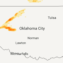
Kansas
| Local Time | Report Details |
|---|---|
| 10:18 PM UTC | Quarter sized hail reported near Hutchinson, KS, 33.7 miles NW of Wichita, KS |
| 10:35 PM UTC | Quarter sized hail reported near Burrton, KS, 29.4 miles NW of Wichita, KS |
| 10:57 PM UTC | Quarter sized hail reported near Haven, KS, 28.4 miles WNW of Wichita, KS |
| 10:58 PM UTC | Golf Ball sized hail reported near Haven, KS, 28.4 miles WNW of Wichita, KS |
| 11:01 PM UTC | Ping Pong Ball sized hail reported near Haven, KS, 28.4 miles WNW of Wichita, KS |
| 6:30 PM CDT | Baseball sized hail reported near Mt Hope, KS, 21.8 miles NW of Wichita, KS |
| 6:38 PM CDT | Grapefruit sized hail reported near Mt Hope, KS, 21.8 miles NW of Wichita, KS, trained spotter reported mostly golfball size hail but a few the size of softballs fell. |
| 6:59 PM CDT | Golf Ball sized hail reported near Bentley, KS, 17.3 miles NW of Wichita, KS |
| 12:05 AM UTC | Quarter sized hail reported near Cheney, KS, 24.4 miles W of Wichita, KS |
| 12:05 AM UTC | Half Dollar sized hail reported near Cheney, KS, 22.2 miles W of Wichita, KS |
| 12:05 AM UTC | Storm damage reported in sedgwick county KS, 15.3 miles WNW of Wichita, KS |
| 12:14 AM UTC | Ping Pong Ball sized hail reported near Cheney, KS, 24.7 miles W of Wichita, KS |
| 12:15 AM UTC | Quarter sized hail reported near Hope, KS, 40.1 miles SW of Manhattan, KS |
| 12:18 AM UTC | Half Dollar sized hail reported near Cheney, KS, 25.8 miles W of Wichita, KS |
| 12:23 AM UTC | Quarter sized hail reported near Cheney, KS, 25.8 miles W of Wichita, KS, on 23rd street south 1 inch hail covering the hail. |
| 12:31 AM UTC | Storm damage reported in sedgwick county KS, 6.7 miles NNW of Wichita, KS |
| 12:34 AM UTC | Quarter sized hail reported near Herington, KS, 34.7 miles SSW of Manhattan, KS |
| 12:35 AM UTC | Storm damage reported in sedgwick county KS, 5.8 miles N of Wichita, KS |
| 12:35 AM UTC | Off duty national weather service employee reported estimated winds of at least 70 mp in sedgwick county KS, 6.7 miles NNW of Wichita, KS |
| 12:35 AM UTC | Reports of an entire yard of shredded leaves and tree limbs at 135th street west and mapl in sedgwick county KS, 6.8 miles W of Wichita, KS |
| 12:39 AM UTC | Half Dollar sized hail reported near Cheney, KS, 22.2 miles W of Wichita, KS |
| 12:40 AM UTC | Golf Ball sized hail reported near Garden Plain, KS, 16.1 miles W of Wichita, KS, occurred with 60 mph winds. |
| 12:40 AM UTC | Occurred with golfball size hai in sedgwick county KS, 16.1 miles W of Wichita, KS |
| 12:41 AM UTC | Storm damage reported in sedgwick county KS, 7 miles NW of Wichita, KS |
| 12:41 AM UTC | Quarter sized hail reported near Wichita, KS, 7 miles NW of Wichita, KS, interstate 235 and meridian |
| 12:42 AM UTC | Quarter sized hail reported near Manhattan, KS, 0.4 miles W of Manhattan, KS |
| 12:43 AM UTC | Storm spotter reported damage to green house in sedgwick county KS, 7.8 miles N of Wichita, KS |
| 12:47 AM UTC | Quarter sized hail reported near Manhattan, KS, 0.8 miles N of Manhattan, KS |
| 12:50 AM UTC | Quarter sized hail reported near Wichita, KS, 6 miles WSW of Wichita, KS, quarter sized hail fell at the national weather service office. |
| 7:50 PM CDT | Ping Pong Ball sized hail reported near Wichita, KS, 6.8 miles W of Wichita, KS, also reported 50 mph winds. occurring at central and 119th. |
| 12:51 AM UTC | Golf Ball sized hail reported near Wichita, KS, 7.9 miles W of Wichita, KS, off duty nws employee reports golf ball size hail. |
| 12:56 AM UTC | Ping Pong Ball sized hail reported near St George, KS, 9.7 miles NE of Manhattan, KS |
| 12:57 AM UTC | Quarter sized hail reported near Wichita, KS, 8.1 miles WSW of Wichita, KS |
| 12:58 AM UTC | Storm damage reported in sedgwick county KS, 7.7 miles NE of Wichita, KS |
| 1:00 AM UTC | Storm damage reported in butler county KS, 10.7 miles E of Wichita, KS |
| 1:00 AM UTC | Powerlines reported down in benton. corrected time...based on rada in butler county KS, 14.3 miles ENE of Wichita, KS |
| 1:00 AM UTC | Power lines reported down in towanda. corrected time based on rada in butler county KS, 20 miles ENE of Wichita, KS |
| 1:00 AM UTC | Quarter sized hail reported near Wichita, KS, 6 miles WSW of Wichita, KS, quarter size hail fell at the national weather service office. |
| 1:00 AM UTC | Quarter sized hail reported near Manhattan, KS, 9.3 miles WNW of Manhattan, KS |
| 1:02 AM UTC | Golf Ball sized hail reported near Wichita, KS, 4.7 miles W of Wichita, KS |
| 1:02 AM UTC | Storm damage reported in butler county KS, 14.3 miles ENE of Wichita, KS |
| 1:04 AM UTC | Damage to backyard. fence is blown down. 3-4 inch trees snape in sedgwick county KS, 9.6 miles E of Wichita, KS |
| 1:06 AM UTC | Quarter sized hail reported near Westmoreland, KS, 16.7 miles NNE of Manhattan, KS, quarter size hail on k-99 on east side of westmoreland. |
| 1:13 AM UTC | Quarter sized hail reported near Olsburg, KS, 18.5 miles NNW of Manhattan, KS |
| 1:14 AM UTC | Quarter sized hail reported near Andover, KS, 15.7 miles ENE of Wichita, KS |
| 1:14 AM UTC | Quarter sized hail reported near Augusta, KS, 16.6 miles ENE of Wichita, KS |
| 1:17 AM UTC | Golf Ball sized hail reported near Onaga, KS, 30 miles NE of Manhattan, KS |
| 1:20 AM UTC | Golf Ball sized hail reported near Onaga, KS, 30.8 miles NE of Manhattan, KS |
| 1:26 AM UTC | Storm damage reported in sedgwick county KS, 7.9 miles W of Wichita, KS |
| 1:27 AM UTC | Storm damage reported in butler county KS, 27.6 miles ENE of Wichita, KS |
| 1:28 AM UTC | 2 foot diameter tree limbs down. corrected time based on rada in butler county KS, 19.5 miles E of Wichita, KS |
| 1:28 AM UTC | Quarter sized hail reported near Onaga, KS, 30 miles NE of Manhattan, KS |
| 1:30 AM UTC | Half Dollar sized hail reported near Eastborough, KS, 4.2 miles E of Wichita, KS, at pawnee and k-15. |
| 1:32 AM UTC | Large tree branch across a roadwa in butler county KS, 27.9 miles ENE of Wichita, KS |
| 1:33 AM UTC | Storm damage reported in butler county KS, 26.6 miles ENE of Wichita, KS |
| 1:34 AM UTC | Storm damage reported in butler county KS, 27.6 miles ENE of Wichita, KS |
| 1:34 AM UTC | Spotter reported 75 mph winds just west of el dorad in butler county KS, 27.6 miles ENE of Wichita, KS |
| 1:42 AM UTC | Quarter sized hail reported near Corning, KS, 42.7 miles NE of Manhattan, KS |
| 1:44 AM UTC | Fire department reports awnings blown off and 2 inch diameter trees broke in butler county KS, 20 miles ENE of Wichita, KS |
| 1:45 AM UTC | Storm damage reported in butler county KS, 30.5 miles E of Wichita, KS |
| 1:50 AM UTC | Storm damage reported in butler county KS, 25 miles ESE of Wichita, KS |
| 1:52 AM UTC | 70 mph winds with penny hai in butler county KS, 27.6 miles ENE of Wichita, KS |
| 1:52 AM UTC | 2 inch diameter tree limbs down in butler county KS, 27.6 miles ENE of Wichita, KS |
| 1:53 AM UTC | City of clearwater is without powe in sedgwick county KS, 15.2 miles SW of Wichita, KS |
| 1:56 AM UTC | Quarter sized hail reported near Axtell, KS, 54.1 miles NNE of Manhattan, KS |
| 1:57 AM UTC | Quarter sized hail reported near Clearwater, KS, 13 miles SW of Wichita, KS |
| 1:58 AM UTC | A trained spotter reported tree damage with one tree up to the size of 9 inches knocked over at herman hill park near pawnee and broadwa in sedgwick county KS, 6.2 miles SSE of Wichita, KS |
| 1:58 AM UTC | Trained spotter reports a sheet metal roof blown off of a mobile home trailer as well as one of the side walls being blown ou in sedgwick county KS, 6.2 miles SSE of Wichita, KS |
| 2:00 AM UTC | Delayed public report of 1 to 2 inch limbs dow in coffey county KS, 34.5 miles NW of Chanute, KS |
| 2:06 AM UTC | Storm damage reported in butler county KS, 12.5 miles ESE of Wichita, KS |
| 2:07 AM UTC | Storm damage reported in sedgwick county KS, 6 miles WSW of Wichita, KS |
| 2:12 AM UTC | 18 inch tree limb down observed by a kwch television storm chaser in sedgwick county KS, 15.2 miles SW of Wichita, KS |
| 2:15 AM UTC | Quarter sized hail reported near Wichita, KS, 9.6 miles E of Wichita, KS |
| 2:16 AM UTC | Storm damage reported in sedgwick county KS, 8.5 miles SSE of Wichita, KS |
| 2:22 AM UTC | Powerlines reported down in bento in butler county KS, 14.3 miles ENE of Wichita, KS |
| 2:22 AM UTC | Power lines reported down in towand in butler county KS, 20 miles ENE of Wichita, KS |
| 2:22 AM UTC | Emergency manager reports powerlines down in sienna ranc in butler county KS, 12.5 miles ESE of Wichita, KS |
| 2:28 AM UTC | 2 foot diameter tree limbs down in butler county KS, 19.5 miles E of Wichita, KS |
| 2:39 AM UTC | Fences and power lines down in butler county KS, 13.9 miles SE of Wichita, KS |
| 3:11 AM UTC | Reports of an entire yard of shredded leaves and tree limbs at 135th street west and mapl in sedgwick county KS, 6.8 miles W of Wichita, KS |
| 3:12 AM UTC | A couple of trees blown over and some siding was blown off a city buildin in sumner county KS, 20.7 miles S of Wichita, KS |
| 5:15 AM UTC | Large tree limbs down in johnson county KS, 20.6 miles SW of Kansas City, MO |
Maryland
| Local Time | Report Details |
|---|---|
| 11:40 PM UTC | Large trees down on north charles stree in baltimore city county MD, 4.8 miles N of Baltimore, MD |
| 11:42 PM UTC | Half Dollar sized hail reported near Walkersville, MD, 41.4 miles WNW of Baltimore, MD |
| 12:17 AM UTC | Quarter sized hail reported near Sykesville, MD, 17.3 miles WNW of Baltimore, MD, quarter hail for about 10 minutes. a few large limbs also down nearby. |
| 12:25 AM UTC | Small tree down on highland roa in anne arundel county MD, 14.3 miles SSW of Baltimore, MD |
| 12:28 AM UTC | Several trees and numerous large limbs down between walton and church st in anne arundel county MD, 4.9 miles S of Baltimore, MD |
| 12:36 AM UTC | Large tree limbs down on walker av in baltimore city county MD, 5.5 miles N of Baltimore, MD |
| 12:40 AM UTC | Storm damage reported in baltimore county MD, 6 miles ESE of Baltimore, MD |
| 12:40 AM UTC | Large trees down on north charles stree in baltimore city county MD, 4.8 miles N of Baltimore, MD |
| 1:00 AM UTC | Trees dow in kent county MD, 20.4 miles ESE of Baltimore, MD |
| 3:45 AM UTC | Storm damage reported in anne arundel county MD, 26.8 miles SSE of Baltimore, MD |
| 3:55 AM UTC | Numerous trees and power lines knocked down... some poles snapped. home under reconstruction damage in queen anne's county MD, 26.7 miles SSE of Baltimore, MD |
| 3:55 AM UTC | Trees dow in queen anne's county MD, 26.8 miles SE of Baltimore, MD |
| 4:05 AM UTC | Trees down in queen anne's county MD, 35.2 miles SE of Baltimore, MD |
Oklahoma
| Local Time | Report Details |
|---|---|
| 12:00 AM UTC | Hen Egg sized hail reported near Cheyenne, OK, 48.3 miles SSW of Woodward, OK |
| 12:00 AM UTC | Storm damage reported in roger mills county OK, 48.3 miles SSW of Woodward, OK |
| 12:05 AM UTC | Hen Egg sized hail reported near Cherokee, OK, 62.3 miles ENE of Woodward, OK |
| 12:06 AM UTC | Quarter sized hail reported near Vici, OK, 20.7 miles SSE of Woodward, OK |
| 12:17 AM UTC | Quarter sized hail reported near Mutual, OK, 21 miles SSE of Woodward, OK, resident reported that hail was covering most of the ground. |
| 12:20 AM UTC | Golf Ball sized hail reported near Mutual, OK, 20.5 miles SE of Woodward, OK |
| 12:45 AM UTC | Emergency manager reported tree limbs 2 to 3 inches in diameter down 2 miles southeast of the us highway 270 and state highway 50 intersectio in woodward county OK, 14.2 miles SE of Woodward, OK |
| 12:49 AM UTC | Quarter sized hail reported near Cheyenne, OK, 48.3 miles SSW of Woodward, OK |
| 1:05 AM UTC | Golf Ball sized hail reported near Waynoka, OK, 38 miles ENE of Woodward, OK |
| 1:23 AM UTC | Report relayed via kwt in roger mills county OK, 56.1 miles S of Woodward, OK |
| 1:31 AM UTC | Quarter sized hail reported near Hammon, OK, 55.4 miles S of Woodward, OK |
| 1:31 AM UTC | Storm damage reported in roger mills county OK, 55.4 miles S of Woodward, OK |
| 2:00 AM UTC | Quarter sized hail reported near Butler, OK, 56 miles SSE of Woodward, OK |
| 2:05 AM UTC | Storm damage reported in custer county OK, 56 miles SSE of Woodward, OK |
| 2:36 AM UTC | Golf Ball sized hail reported near Arapaho, OK, 63.8 miles SSE of Woodward, OK, reported by the custer county sheriff dept |
Ohio
| Local Time | Report Details |
|---|---|
| 1:35 AM UTC | Numerous reports of trees and power lines down...mainly on the east side of chillicoth in ross county OH, 42.9 miles S of Columbus, OH |
| 2:35 AM UTC | Tree down in vinton county OH, 52.6 miles SSE of Columbus, OH |
Delaware
| Local Time | Report Details |
|---|---|
| 1:50 AM UTC | Trees dow in kent county DE, 53.6 miles E of Baltimore, MD |
Connect with Interactive Hail Maps