

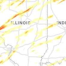
Hail Map for Friday, March 31, 2023

Number of Impacted Households on 3/31/2023
0
Impacted by 1" or Larger Hail
0
Impacted by 1.75" or Larger Hail
0
Impacted by 2.5" or Larger Hail
Square Miles of Populated Area Impacted on 3/31/2023
0
Impacted by 1" or Larger Hail
0
Impacted by 1.75" or Larger Hail
0
Impacted by 2.5" or Larger Hail


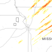


Cities Most Affected by Hail Storms of 3/31/2023
| Hail Size | Demographics of Zip Codes Affected | ||||||
|---|---|---|---|---|---|---|---|
| City | Count | Average | Largest | Pop Density | House Value | Income | Age |
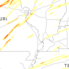
| Hannibal, MO | 14 | 1.95 | 2.75 | 209 | $63k | $31.2k | 38.2 |
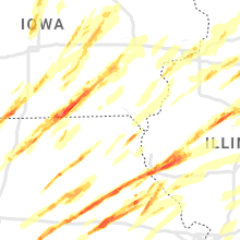
| Liberty, IL | 4 | 2.50 | 3.00 | 16 | $69k | $40.5k | 39.9 |
| Centerville, IA | 4 | 2.50 | 2.75 | 59 | $48k | $28.5k | 43.1 |
| Columbia, MO | 5 | 1.85 | 2.00 | 525 | $114k | $33.2k | 27.0 |
| Mount Sterling, IL | 4 | 1.88 | 2.00 | 20 | $50k | $34.0k | 35.8 |
| Roanoke, IL | 3 | 2.08 | 2.50 | 31 | $90k | $46.0k | 41.3 |
| Canton, IL | 2 | 2.25 | 2.75 | 102 | $63k | $33.4k | 40.2 |
| Laddonia, MO | 2 | 1.75 | 1.75 | 9 | $46k | $32.9k | 43.8 |
| Murray, IA | 2 | 1.75 | 1.75 | 12 | $50k | $32.9k | 39.5 |
| Peoria Heights, IL | 2 | 1.75 | 1.75 | 2602 | $0k | $0.0k | 37.9 |
| South Bend, IN | 1 | 2.00 | 2.00 | 562 | $93k | $43.2k | 41.8 |
| Mc Caskill, AR | 1 | 2.00 | 2.00 | 10 | $46k | $35.7k | 43.8 |
| Versailles, IL | 1 | 2.00 | 2.00 | 10 | $40k | $38.1k | 46.1 |
| Hull, IL | 1 | 2.00 | 2.00 | 7 | $49k | $32.3k | 41.6 |
| Clark, MO | 1 | 2.00 | 2.00 | 30 | $57k | $32.5k | 29.4 |
| Joaquin, TX | 1 | 2.00 | 2.00 | 29 | $49k | $29.6k | 38.7 |
| North Liberty, IA | 1 | 1.75 | 1.75 | 485 | $117k | $47.5k | 29.8 |
| Lathrop, MO | 1 | 1.75 | 1.75 | 43 | $85k | $41.0k | 39.4 |
| Lucas, IA | 1 | 1.75 | 1.75 | 8 | $37k | $39.8k | 48.2 |
| Knob Noster, MO | 1 | 1.75 | 1.75 | 53 | $81k | $32.5k | 30.6 |
| Sturgis, MI | 1 | 1.75 | 1.75 | 241 | $87k | $39.8k | 36.8 |
| Melbourne, IA | 1 | 1.75 | 1.75 | 16 | $73k | $48.9k | 37.4 |
| Sheridan, AR | 1 | 1.75 | 1.75 | 41 | $74k | $39.0k | 40.1 |
| Ashland, IL | 1 | 1.75 | 1.75 | 13 | $71k | $42.9k | 43.1 |
| Curryville, MO | 1 | 1.75 | 1.75 | 12 | $78k | $28.5k | 37.2 |
| Jadwin, MO | 1 | 1.75 | 1.75 | 13 | $85k | $25.8k | 48.4 |
| Mount Ayr, IA | 1 | 1.75 | 1.75 | 17 | $52k | $29.3k | 47.4 |
| Neponset, IL | 1 | 1.75 | 1.75 | 12 | $60k | $38.9k | 45.1 |
| Stuttgart, AR | 1 | 1.75 | 1.75 | 32 | $60k | $32.2k | 39.2 |
| Peoria, IL | 1 | 1.75 | 1.75 | 348 | $86k | $46.7k | 42.4 |
| Ames, IA | 1 | 1.75 | 1.75 | 484 | $159k | $37.3k | 23.3 |
| Auxvasse, MO | 1 | 1.75 | 1.75 | 23 | $71k | $37.2k | 39.8 |
| Tiskilwa, IL | 1 | 1.75 | 1.75 | 14 | $82k | $39.2k | 44.5 |
| Fremont, IN | 1 | 1.75 | 1.75 | 101 | $121k | $45.5k | 43.9 |
| Belleville, IL | 1 | 1.75 | 1.75 | 682 | $86k | $47.6k | 42.9 |
| Mexico, MO | 1 | 1.75 | 1.75 | 67 | $67k | $33.0k | 38.9 |
| Benton City, MO | 1 | 1.75 | 1.75 | 7 | $55k | $41.0k | 48.6 |
| Centralia, MO | 1 | 1.75 | 1.75 | 43 | $75k | $39.0k | 39.7 |
| Benson, IL | 1 | 1.75 | 1.75 | 9 | $76k | $50.7k | 37.0 |
| Sumner, MO | 1 | 1.75 | 1.75 | 3 | $34k | $19.2k | 49.7 |
| Herculaneum, MO | 1 | 1.75 | 1.75 | 939 | $85k | $38.4k | 37.9 |
| Kirksville, MO | 1 | 1.75 | 1.75 | 94 | $79k | $25.8k | 26.0 |
| Fayette, MO | 1 | 1.75 | 1.75 | 23 | $66k | $32.1k | 34.4 |
| Whiteman Air Force Base, MO | 1 | 1.75 | 1.75 | 525 | $0k | $33.7k | 21.4 |
| Lakeville, IN | 1 | 1.75 | 1.75 | 84 | $89k | $46.4k | 43.0 |
| Princeton, MO | 1 | 1.75 | 1.75 | 10 | $35k | $31.0k | 41.9 |
| Sullivan, MO | 1 | 1.75 | 1.75 | 53 | $78k | $36.0k | 38.8 |
| Ozan, AR | 1 | 1.75 | 1.75 | 10 | $39k | $25.2k | 42.3 |
| Stoutsville, MO | 1 | 1.75 | 1.75 | 9 | $80k | $30.4k | 53.9 |
| Gilman, IA | 1 | 1.75 | 1.75 | 12 | $65k | $40.2k | 44.9 |
| Mount Pleasant, TX | 1 | 1.75 | 1.75 | 95 | $65k | $32.9k | 31.6 |
| Trenton, MO | 1 | 1.75 | 1.75 | 37 | $48k | $27.3k | 42.5 |
| Tenaha, TX | 1 | 1.75 | 1.75 | 22 | $48k | $27.1k | 35.1 |
Hail and Wind Damage Spotted on 3/31/2023
Filter by Report Type:Hail ReportsWind Reports
States Impacted
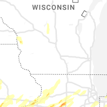
Missouri, Tennessee, Iowa, Illinois, Oklahoma, Texas, Colorado, Arkansas, Kansas, Indiana, Wisconsin, Michigan, Mississippi, Kentucky, Ohio, Louisiana, Alabama, GeorgiaMissouri
| Local Time | Report Details |
|---|---|
| 11:38 AM CDT | Quarter sized hail reported near Malta Bend, MO, 57.5 miles WNW of Columbia, MO |
| 11:42 AM CDT | Half Dollar sized hail reported near Malta Bend, MO, 54.5 miles WNW of Columbia, MO |
| 12:03 PM CDT | Half Dollar sized hail reported near Keytesville, MO, 45.9 miles NW of Columbia, MO |
| 12:07 PM CDT | Quarter sized hail reported near Salisbury, MO, 41.4 miles NW of Columbia, MO |
| 12:10 PM CDT | Ping Pong Ball sized hail reported near Gainesville, MO, 71.9 miles SE of Springfield, MO, 1.5 inch hail reported just south of the missouri state line on ar-highway 201. |
| 12:45 PM CDT | Half Dollar sized hail reported near New London, MO, 56.3 miles SSE of Kahoka, MO, delayed report. |
| 12:47 PM CDT | Quarter sized hail reported near West Plains, MO, 62.2 miles SSW of Salem, MO, report from mping: quarter (1.00 in.). |
| 12:48 PM CDT | Half Dollar sized hail reported near New London, MO, 56.3 miles SSE of Kahoka, MO |
| 12:50 PM CDT | Quarter sized hail reported near New London, MO, 55.9 miles SSE of Kahoka, MO, report from mping: quarter (1.00 in.). |
| 12:50 PM CDT | Golf Ball sized hail reported near Hannibal, MO, 53.5 miles SSE of Kahoka, MO |
| 12:54 PM CDT | Quarter sized hail reported near Hannibal, MO, 51 miles SSE of Kahoka, MO, report from mping: quarter (1.00 in.). |
| 12:55 PM CDT | Quarter sized hail reported near Hannibal, MO, 51.6 miles SSE of Kahoka, MO |
| 12:56 PM CDT | Golf Ball sized hail reported near Hannibal, MO, 52.2 miles SSE of Kahoka, MO, law enforcement relayed reports of hail ranging from pea to golf ball size. |
| 12:59 PM CDT | Quarter sized hail reported near Hannibal, MO, 52.6 miles SSE of Kahoka, MO, public report relayed by media. |
| 1:00 PM CDT | Quarter sized hail reported near Hannibal, MO, 52.7 miles SSE of Kahoka, MO |
| 1:08 PM CDT | Golf Ball sized hail reported near Jadwin, MO, 11 miles S of Salem, MO, public business in jadwin. |
| 1:30 PM CDT | Quarter sized hail reported near Winston, MO, 60.9 miles NNE of Kansas City, MO |
| 1:30 PM CDT | Quarter sized hail reported near Leeton, MO, 59.3 miles SE of Kansas City, MO |
| 1:40 PM CDT | Golf Ball sized hail reported near Lathrop, MO, 33.5 miles NNE of Kansas City, MO |
| 1:40 PM CDT | Quarter sized hail reported near Jamesport, MO, 76.9 miles NNE of Kansas City, MO |
| 1:42 PM CDT | Half Dollar sized hail reported near Gilman City, MO, 81.6 miles NNE of Kansas City, MO |
| 1:42 PM CDT | Golf Ball sized hail reported near Knob Noster, MO, 60.5 miles ESE of Kansas City, MO |
| 1:43 PM CDT | Half Dollar sized hail reported near Whiteman Air Force Base, MO, 61 miles ESE of Kansas City, MO |
| 1:43 PM CDT | Tree down over highway 81. public report relayed by law enforcemen in clark county MO, 7.8 miles SSE of Kahoka, MO |
| 1:48 PM CDT | Golf Ball sized hail reported near Whiteman Air Force Base, MO, 60.1 miles ESE of Kansas City, MO |
| 2:00 PM CDT | Quarter sized hail reported near Princeton, MO, 82.1 miles S of Des Moines, IA |
| 2:00 PM CDT | Ping Pong Ball sized hail reported near Princeton, MO, 82.1 miles S of Des Moines, IA |
| 2:02 PM CDT | Quarter sized hail reported near Princeton, MO, 82.1 miles S of Des Moines, IA |
| 2:06 PM CDT | Golf Ball sized hail reported near Princeton, MO, 91.1 miles S of Des Moines, IA |
| 2:14 PM CDT | Half Dollar sized hail reported near Blackwater, MO, 35.4 miles W of Columbia, MO |
| 2:15 PM CDT | Half Dollar sized hail reported near Nelson, MO, 37.6 miles W of Columbia, MO |
| 2:17 PM CDT | Quarter sized hail reported near Blackwater, MO, 37 miles W of Columbia, MO |
| 2:27 PM CDT | Ping Pong Ball sized hail reported near Powersville, MO, 77.3 miles SSE of Des Moines, IA |
| 2:31 PM CDT | Golf Ball sized hail reported near Sumner, MO, 68.4 miles NW of Columbia, MO |
| 2:32 PM CDT | Quarter sized hail reported near Trenton, MO, 85.7 miles NE of Kansas City, MO |
| 2:34 PM CDT | Golf Ball sized hail reported near Trenton, MO, 85.2 miles NE of Kansas City, MO |
| 2:40 PM CDT | Quarter sized hail reported near Brookfield, MO, 69.4 miles NW of Columbia, MO |
| 2:40 PM CDT | Golf Ball sized hail reported near Fayette, MO, 23.5 miles NW of Columbia, MO |
| 2:46 PM CDT | Metal lean-to knocked ove in mercer county MO, 88.3 miles S of Des Moines, IA |
| 2:50 PM CDT | Ping Pong Ball sized hail reported near Brookfield, MO, 70.3 miles NW of Columbia, MO |
| 2:51 PM CDT | Tree and power-lines dow in grundy county MO, 84.4 miles NE of Kansas City, MO |
| 2:53 PM CDT | Quarter sized hail reported near Brookfield, MO, 72.5 miles NNW of Columbia, MO |
| 2:57 PM CDT | Ping Pong Ball sized hail reported near Clark, MO, 22.6 miles N of Columbia, MO |
| 2:57 PM CDT | Hen Egg sized hail reported near Clark, MO, 22.6 miles N of Columbia, MO |
| 3:10 PM CDT | Ping Pong Ball sized hail reported near Clark, MO, 24.1 miles N of Columbia, MO, report relayed by emergency management. time estimated by radar. |
| 3:20 PM CDT | Golf Ball sized hail reported near Kirksville, MO, 47.4 miles WSW of Kahoka, MO |
| 3:20 PM CDT | Quarter sized hail reported near Madison, MO, 30.9 miles NNE of Columbia, MO, delayed report. |
| 3:33 PM CDT | Quarter sized hail reported near Milan, MO, 74.9 miles W of Kahoka, MO |
| 3:33 PM CDT | Golf Ball sized hail reported near Columbia, MO, 7.6 miles SW of Columbia, MO |
| 3:33 PM CDT | Golf Ball sized hail reported near Stoutsville, MO, 44.7 miles NNE of Columbia, MO, trained spotter called to report golf ball size hail was falling. hail is resulting in broken windows at the residence. |
| 3:35 PM CDT | Half Dollar sized hail reported near Columbia, MO, 2.2 miles S of Columbia, MO, delayed report. |
| 3:35 PM CDT | Golf Ball sized hail reported near Columbia, MO, 3.6 miles S of Columbia, MO |
| 3:35 PM CDT | Hen Egg sized hail reported near Columbia, MO, 3.2 miles SSE of Columbia, MO |
| 3:36 PM CDT | Quarter sized hail reported near Columbia, MO, 2.4 miles SE of Columbia, MO |
| 3:38 PM CDT | Quarter sized hail reported near Unionville, MO, 69.7 miles W of Kahoka, MO |
| 3:38 PM CDT | Hen Egg sized hail reported near Columbia, MO, 2.9 miles SE of Columbia, MO |
| 3:40 PM CDT | Quarter sized hail reported near Columbia, MO, 3.2 miles SSE of Columbia, MO |
| 3:40 PM CDT | Ping Pong Ball sized hail reported near Columbia, MO, 2 miles ESE of Columbia, MO |
| 3:41 PM CDT | Quarter sized hail reported near Columbia, MO, 4.2 miles ENE of Columbia, MO |
| 3:45 PM CDT | Quarter sized hail reported near Monroe City, MO, 56.7 miles S of Kahoka, MO |
| 3:45 PM CDT | Golf Ball sized hail reported near Centralia, MO, 14.5 miles NE of Columbia, MO |
| 3:45 PM CDT | Half Dollar sized hail reported near Columbia, MO, 2.4 miles ENE of Columbia, MO |
| 3:46 PM CDT | Half Dollar sized hail reported near Columbia, MO, 2.9 miles SE of Columbia, MO, report from mping: half dollar (1.25 in.). |
| 3:48 PM CDT | Golf Ball sized hail reported near Columbia, MO, 3.7 miles SSE of Columbia, MO, report from south columbia. |
| 3:57 PM CDT | Tree down. report via 911 cente in putnam county MO, 59.7 miles W of Kahoka, MO |
| 3:58 PM CDT | Quarter sized hail reported near Columbia, MO, 3.7 miles ENE of Columbia, MO, report from mping: quarter (1.00 in.). |
| 3:59 PM CDT | Baseball sized hail reported near Hannibal, MO, 51.1 miles SSE of Kahoka, MO, house was being heavily damaged by baseball size hail. |
| 3:59 PM CDT | Ping Pong Ball sized hail reported near Hannibal, MO, 53.6 miles SSE of Kahoka, MO, report from mping: ping pong ball (1.50 in.). |
| 4:00 PM CDT | Quarter sized hail reported near Mexico, MO, 28.7 miles ENE of Columbia, MO |
| 4:00 PM CDT | Ping Pong Ball sized hail reported near Hannibal, MO, 53.5 miles SSE of Kahoka, MO |
| 4:00 PM CDT | Hen Egg sized hail reported near Hannibal, MO, 51.2 miles SSE of Kahoka, MO, time estimated from radar. |
| 4:01 PM CDT | Golf Ball sized hail reported near Hannibal, MO, 53.6 miles SSE of Kahoka, MO, report from mping: golf ball (1.75 in.). |
| 4:01 PM CDT | Golf Ball sized hail reported near Hannibal, MO, 51.4 miles SSE of Kahoka, MO |
| 4:02 PM CDT | Quarter sized hail reported near Hannibal, MO, 52.1 miles SSE of Kahoka, MO, report from mping: quarter (1.00 in.). |
| 4:02 PM CDT | Quarter sized hail reported near Mexico, MO, 27.9 miles ENE of Columbia, MO, report from mping: quarter (1.00 in.). |
| 4:03 PM CDT | Quarter sized hail reported near Hannibal, MO, 52.9 miles SSE of Kahoka, MO |
| 4:03 PM CDT | Ping Pong Ball sized hail reported near Hannibal, MO, 52.2 miles SSE of Kahoka, MO |
| 4:03 PM CDT | Quarter sized hail reported near Mexico, MO, 27.9 miles ENE of Columbia, MO |
| 4:04 PM CDT | Golf Ball sized hail reported near Curryville, MO, 57.5 miles ENE of Columbia, MO |
| 4:04 PM CDT | Half Dollar sized hail reported near Hannibal, MO, 52.1 miles SSE of Kahoka, MO |
| 4:05 PM CDT | Quarter sized hail reported near Mexico, MO, 27.9 miles ENE of Columbia, MO |
| 4:05 PM CDT | Golf Ball sized hail reported near Mexico, MO, 28.2 miles ENE of Columbia, MO |
| 4:05 PM CDT | Tennis Ball sized hail reported near Hannibal, MO, 52.9 miles SSE of Kahoka, MO |
| 4:05 PM CDT | Ping Pong Ball sized hail reported near Auxvasse, MO, 21.7 miles ENE of Columbia, MO |
| 4:05 PM CDT | Golf Ball sized hail reported near Auxvasse, MO, 20.2 miles ENE of Columbia, MO, hail getting bigger. |
| 4:05 PM CDT | Golf Ball sized hail reported near Hannibal, MO, 52.6 miles SSE of Kahoka, MO |
| 4:06 PM CDT | Quarter sized hail reported near Mexico, MO, 30.7 miles ENE of Columbia, MO, report from mping: quarter (1.00 in.). |
| 4:06 PM CDT | Half Dollar sized hail reported near Hannibal, MO, 53.4 miles SSE of Kahoka, MO |
| 4:06 PM CDT | Golf Ball sized hail reported near Hannibal, MO, 52.2 miles SSE of Kahoka, MO |
| 4:07 PM CDT | Half Dollar sized hail reported near Hannibal, MO, 53.7 miles SSE of Kahoka, MO |
| 4:08 PM CDT | Ping Pong Ball sized hail reported near Mexico, MO, 31.5 miles ENE of Columbia, MO |
| 4:08 PM CDT | Golf Ball sized hail reported near Benton City, MO, 35.4 miles ENE of Columbia, MO |
| 4:09 PM CDT | Hen Egg sized hail reported near Hannibal, MO, 53.2 miles SSE of Kahoka, MO |
| 4:10 PM CDT | Hen Egg sized hail reported near Hannibal, MO, 52.8 miles SSE of Kahoka, MO, delayed report. |
| 4:11 PM CDT | Golf Ball sized hail reported near Hannibal, MO, 52.1 miles SSE of Kahoka, MO, up to golf ball sized hail... ended at the time of the call. very heavy rain falling now. |
| 4:13 PM CDT | Quarter sized hail reported near Mexico, MO, 30.3 miles ENE of Columbia, MO |
| 4:15 PM CDT | Quarter sized hail reported near Farber, MO, 46.4 miles ENE of Columbia, MO, delayed report. |
| 4:15 PM CDT | Hen Egg sized hail reported near Hannibal, MO, 52.7 miles SSE of Kahoka, MO |
| 4:16 PM CDT | Ping Pong Ball sized hail reported near Laddonia, MO, 42.3 miles ENE of Columbia, MO, report from mping: ping pong ball (1.50 in.). |
| 4:17 PM CDT | Ping Pong Ball sized hail reported near Laddonia, MO, 42.3 miles ENE of Columbia, MO, reported by county dispatch. |
| 4:19 PM CDT | Half Dollar sized hail reported near Laddonia, MO, 42.6 miles ENE of Columbia, MO, time estimated from radar. |
| 4:20 PM CDT | Golf Ball sized hail reported near Laddonia, MO, 42.3 miles ENE of Columbia, MO, report from mping: golf ball (1.75 in.). |
| 4:21 PM CDT | Half Dollar sized hail reported near Laddonia, MO, 43.2 miles ENE of Columbia, MO |
| 4:25 PM CDT | Golf Ball sized hail reported near Hannibal, MO, 53.5 miles SSE of Kahoka, MO, mping report... time estimated from radar. |
| 4:30 PM CDT | Ping Pong Ball sized hail reported near Vandalia, MO, 51.6 miles ENE of Columbia, MO |
| 4:45 PM CDT | Quarter sized hail reported near Montgomery City, MO, 41.7 miles E of Columbia, MO, delayed report. |
| 5:10 PM CDT | Quarter sized hail reported near Salem, MO, 6.1 miles ESE of Salem, MO, delayed report via social media. |
| 5:15 PM CDT | Half Dollar sized hail reported near Sullivan, MO, 44.9 miles NNE of Salem, MO, spotter called back with an update out of sullivan. largest hail the spotter observed was slightly larger than a quarter. time estimated by radar. |
| 5:16 PM CDT | Golf Ball sized hail reported near Sullivan, MO, 44.9 miles NNE of Salem, MO, also reported rotating wall cloud. |
| 5:20 PM CDT | Light damage to buildings... signs blown down... and 3-8 inch tree limbs down. estimate near 70-80 mph wind in clark county MO, 0.6 miles N of Kahoka, MO |
| 5:24 PM CDT | Mtn view pd howell co reports wind damage... trees down... structural damag in howell county MO, 44.7 miles S of Salem, MO |
| 5:25 PM CDT | Quarter sized hail reported near Troy, MO, 48.6 miles WNW of Saint Louis, MO |
| 6:10 PM CDT | Quarter sized hail reported near De Soto, MO, 39.3 miles SSW of Saint Louis, MO, delayed report... time estimated from radar. |
| 6:18 PM CDT | Golf Ball sized hail reported near Herculaneum, MO, 29.1 miles SSW of Saint Louis, MO, report from mping: golf ball (1.75 in.). |
| 6:18 PM CDT | Golf Ball sized hail reported near Laddonia, MO, 42.3 miles ENE of Columbia, MO |
| 6:19 PM CDT | Quarter sized hail reported near Crystal City, MO, 28.5 miles SSW of Saint Louis, MO, delayed report. |
| 6:19 PM CDT | Ping Pong Ball sized hail reported near Crystal City, MO, 28.5 miles SSW of Saint Louis, MO, delayed report... time estimated from radar. |
| 6:20 PM CDT | Quarter sized hail reported near De Soto, MO, 39.3 miles SSW of Saint Louis, MO |
| 6:27 PM CDT | Spotter was south of exit 175 off of i-55 and estimated winds approached 60 mp in jefferson county MO, 30.8 miles SSW of Saint Louis, MO |
| 6:31 PM CDT | Quarter sized hail reported near Festus, MO, 32.9 miles SSW of Saint Louis, MO |
| 6:32 PM CDT | Ping Pong Ball sized hail reported near Crystal City, MO, 29.1 miles SSW of Saint Louis, MO, delayed report. |
| 7:30 PM CDT | Large tree branch over 8 inches in diameter broken off tre in st. louis county MO, 7.3 miles WSW of Saint Louis, MO |
| 7:45 PM CDT | Delayed report. time estimated from radar. large tree down across roa in jefferson county MO, 24.9 miles SSW of Saint Louis, MO |
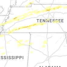
Tennessee
| Local Time | Report Details |
|---|---|
| 11:59 AM CDT | Quarter sized hail reported near Goodlettsville, TN, 12.2 miles NNW of Nashville, TN, quarter size hail via mping. |
| 6:00 PM CDT | Large trees down near akins store road and highway 5 in tipton county TN, 28.7 miles NE of Memphis, TN |
| 6:19 PM CDT | Mesonet station tt531 covingto in tipton county TN, 39.9 miles NE of Memphis, TN |
| 8:47 PM CDT | Report from mping: 3-inch tree limbs broken; power poles broke in carroll county TN, 11.4 miles S of Mc Kenzie, TN |
| 9:40 PM CDT | A wall collapsed on a house on flowers road near bethel spring in mcnairy county TN, 61.1 miles WNW of Florence, AL |
| 9:40 PM CDT | Reports of damage on buena vista roa in mcnairy county TN, 61.9 miles S of Mc Kenzie, TN |
| 9:56 PM CDT | Trees down near the intersection of dowty road and peach street on the north side of selme in mcnairy county TN, 57.8 miles WNW of Florence, AL |
| 11:18 PM CDT | Trees uprooted or snapped; roof blown of in benton county TN, 25.3 miles ESE of Mc Kenzie, TN |
| 11:53 PM CDT | Trees and power lines down along hwy 128 just south of bryant l in wayne county TN, 43.7 miles NNW of Florence, AL |
| 12:18 AM CDT | Quarter sized hail reported near Gallatin, TN, 23.5 miles NE of Nashville, TN, twitter report w/ photo. |
| 12:20 AM CDT | *** tornado possible *** trees and lines down... road impassible and heavy residential structural damage along james whitehead rd. in grinders cree in lewis county TN, 47.3 miles N of Florence, AL |
| 12:29 AM CDT | Ping Pong Ball sized hail reported near Ashland City, TN, 11 miles NW of Nashville, TN, ping pong ball sized hail via mping. |
| 12:29 AM CDT | *** tornado possible *** houses with heavy damage in the 2100 block of buffalo r in lewis county TN, 48 miles N of Florence, AL |
| 12:33 AM CDT | Quarter sized hail reported near Castalian Springs, TN, 32.2 miles NE of Nashville, TN, quarter size hail via mping. |
| 12:45 AM CDT | Quarter sized hail reported near Hartsville, TN, 37.8 miles ENE of Nashville, TN, hwy 10 and old lafayette rd. |
| 12:45 AM CDT | Trees down in downtown hartsville at hayes st./rodgers s in trousdale county TN, 37.8 miles ENE of Nashville, TN |
| 12:51 AM CDT | Quarter sized hail reported near Lafayette, TN, 49.5 miles ENE of Nashville, TN |
| 12:55 AM CDT | Roof of home collapsed and trees down on rose lane. possible tornad in macon county TN, 46 miles ENE of Nashville, TN |
| 12:57 AM CDT | Large maple tree down on browns road east of lafayette. time estimated based on rada in macon county TN, 50.6 miles ENE of Nashville, TN |
| 1:08 AM CDT | Quarter sized hail reported near Spring Hill, TN, 30.5 miles SSW of Nashville, TN, twitter report w/ photo. |
| 1:19 AM CDT | *** tornado possible *** power lines down... carport and fencing mangled... building debris in road on beasley rd near tennessee central rd (twitter report in marshall county TN, 40 miles S of Nashville, TN |
| 1:19 AM CDT | *** tornado possible *** power lines down... carport and fencing mangled... building debris in road on beasley rd near tennessee central rd (twitter report in marshall county TN, 34.8 miles S of Nashville, TN |
| 1:20 AM CDT | Twitter reports of five train cars overturned one half mile south of nashville hwy and thick road intersection. possible tornad in marshall county TN, 34 miles S of Nashville, TN |
| 1:25 AM CDT | Several trees down near 10800 block of bunker hill road in rockvale... t in rutherford county TN, 32.9 miles SSE of Nashville, TN |
| 1:31 AM CDT | *** tornado possible *** house damage...800f roof is gone (twitter report in rutherford county TN, 32.6 miles SSE of Nashville, TN |
| 1:39 AM CDT | Tree reportedly fell through house on troupe roa in bedford county TN, 47.8 miles SSE of Nashville, TN |
| 1:42 AM CDT | Trees down on multiple locations: elam rd... bivens hill rd and 9951 john bragg hw in rutherford county TN, 35.7 miles SE of Nashville, TN |
| 1:52 AM CDT | Twitter report of house on old woodbury pike lost part of roof... garages... patio... and several tree in rutherford county TN, 40.8 miles SE of Nashville, TN |
| 2:09 AM CDT | Mesonet station av589 short mountai in cannon county TN, 49.7 miles ESE of Nashville, TN |
| 2:35 AM CDT | Power lines... utility poles... and trees down near milk plant road. multiple other trees down across western and northern white count in white county TN, 68.3 miles N of Chattanooga, TN |
| 2:50 AM CDT | A tree fell onto the corner of a house on old spencer roa in bledsoe county TN, 41.2 miles N of Chattanooga, TN |
| 2:51 AM CDT | *** tornado possible *** multiple homes damaged (one collapsed) on readyville s in rutherford county TN, 40.8 miles SE of Nashville, TN |
| 4:10 AM EDT | Several trees dow in morgan county TN, 46.1 miles WNW of Knoxville, TN |
| 4:11 AM EDT | 1 tree down on road near spring cit in rhea county TN, 51.1 miles NNE of Chattanooga, TN |
| 4:30 AM EDT | Numerous trees were blown down around knox count in knox county TN, 1.8 miles WNW of Knoxville, TN |
| 5:50 AM EDT | Powerlines down on mint road... trees reported down in the count in blount county TN, 22.3 miles SSW of Knoxville, TN |
| 6:00 AM EDT | Powerlines down and damaged utility pole near seymou in blount county TN, 14.6 miles SE of Knoxville, TN |
Iowa
| Local Time | Report Details |
|---|---|
| 12:40 PM CDT | Golf Ball sized hail reported near Mount Ayr, IA, 73.2 miles SSW of Des Moines, IA, relayed by who-tv13 in des moines. |
| 12:49 PM CDT | Quarter sized hail reported near Osceola, IA, 39.4 miles S of Des Moines, IA |
| 1:50 PM CDT | Golf Ball sized hail reported near Lucas, IA, 39.5 miles SSE of Des Moines, IA, relayed by knia/krls radio. |
| 1:53 PM CDT | Golf Ball sized hail reported near Murray, IA, 42.4 miles SSW of Des Moines, IA |
| 1:59 PM CDT | Golf Ball sized hail reported near Murray, IA, 42.4 miles SSW of Des Moines, IA, report from mping: golf ball (1.75 in.). |
| 1:59 PM CDT | Delayed report. one-inch tree limbs broken. shingles blown of in clarke county IA, 42.4 miles SSW of Des Moines, IA |
| 2:08 PM CDT | Quarter sized hail reported near New London, IA, 37.6 miles NNE of Kahoka, MO |
| 2:29 PM CDT | Ping Pong Ball sized hail reported near Woodburn, IA, 38.7 miles S of Des Moines, IA, clarke county ema from conservation on highway 34 on the lucas/clarke county line. time estimated from radar. |
| 2:35 PM CDT | Golf Ball sized hail reported near Melbourne, IA, 35.6 miles NE of Des Moines, IA |
| 2:43 PM CDT | Quarter sized hail reported near Lacona, IA, 30.2 miles SSE of Des Moines, IA |
| 2:47 PM CDT | Quarter sized hail reported near Ames, IA, 28.6 miles N of Des Moines, IA, via email. time estimated from radar. |
| 2:47 PM CDT | Quarter sized hail reported near Kelley, IA, 24.1 miles NNW of Des Moines, IA, estimated 50 mph gusts. |
| 2:50 PM CDT | Golf Ball sized hail reported near Ames, IA, 29.8 miles N of Des Moines, IA, golf ball sized hail covering the ground. |
| 2:50 PM CDT | Quarter sized hail reported near Ames, IA, 31.8 miles N of Des Moines, IA |
| 2:50 PM CDT | Quarter sized hail reported near Ames, IA, 30.6 miles N of Des Moines, IA, hail started about 2:50pm and lasted until 2:54pm. largest hailstones were almost 1 inch in diameter. accumulated in drifts due to strong winds from the south. also acc |
| 2:52 PM CDT | Half Dollar sized hail reported near Ames, IA, 29.7 miles N of Des Moines, IA |
| 2:52 PM CDT | Quarter sized hail reported near Ames, IA, 29 miles N of Des Moines, IA, report from mping: quarter (1.00 in.). |
| 2:53 PM CDT | Quarter sized hail reported near Ames, IA, 29.8 miles N of Des Moines, IA, report from mping: quarter (1.00 in.). |
| 2:53 PM CDT | Quarter sized hail reported near Ames, IA, 31.4 miles N of Des Moines, IA, very strong winds. |
| 2:54 PM CDT | Hen Egg sized hail reported near Centerville, IA, 64.2 miles WNW of Kahoka, MO |
| 2:55 PM CDT | Tennis Ball sized hail reported near Centerville, IA, 64.2 miles WNW of Kahoka, MO |
| 2:55 PM CDT | Quarter sized hail reported near Ames, IA, 29.8 miles N of Des Moines, IA, report from mping: quarter (1.00 in.). |
| 2:55 PM CDT | Quarter sized hail reported near Mystic, IA, 65 miles SSE of Des Moines, IA |
| 2:56 PM CDT | Baseball sized hail reported near Centerville, IA, 64.2 miles WNW of Kahoka, MO |
| 2:56 PM CDT | Half Dollar sized hail reported near Ames, IA, 29.9 miles N of Des Moines, IA, some siding damage. |
| 2:57 PM CDT | Quarter sized hail reported near Ames, IA, 30.4 miles N of Des Moines, IA, report from mping: quarter (1.00 in.). |
| 3:00 PM CDT | Quarter sized hail reported near Gilbert, IA, 35.9 miles N of Des Moines, IA |
| 3:01 PM CDT | Quarter sized hail reported near Story City, IA, 40.1 miles N of Des Moines, IA |
| 3:02 PM CDT | Quarter sized hail reported near Moravia, IA, 63.9 miles SE of Des Moines, IA |
| 3:05 PM CDT | Tennis Ball sized hail reported near Centerville, IA, 64.2 miles WNW of Kahoka, MO |
| 3:08 PM CDT | Half Dollar sized hail reported near Knoxville, IA, 32.6 miles SE of Des Moines, IA |
| 3:08 PM CDT | Golf Ball sized hail reported near Gilman, IA, 47.1 miles ENE of Des Moines, IA, via phone. |
| 3:09 PM CDT | Quarter sized hail reported near Knoxville, IA, 31.4 miles SE of Des Moines, IA, report from mping: quarter (1.00 in.). |
| 3:19 PM CDT | Ping Pong Ball sized hail reported near Pella, IA, 33.3 miles ESE of Des Moines, IA, report from mping: ping pong ball (1.50 in.). |
| 3:22 PM CDT | Quarter sized hail reported near Knoxville, IA, 32.6 miles SE of Des Moines, IA, image submitted via social media. |
| 3:23 PM CDT | Ping Pong Ball sized hail reported near Pella, IA, 38.2 miles ESE of Des Moines, IA, via knia/krls. |
| 3:39 PM CDT | Storm damage reported in wapello county IA, 54.7 miles NW of Kahoka, MO |
| 3:44 PM CDT | Quarter sized hail reported near Mason City, IA, 1.2 miles S of Mason City, IA |
| 3:49 PM CDT | Quarter sized hail reported near Mason City, IA, 0.2 miles NNE of Mason City, IA |
| 3:55 PM CDT | Half Dollar sized hail reported near Wesley, IA, 40.1 miles W of Mason City, IA |
| 3:55 PM CDT | Quarter sized hail reported near Waverly, IA, 46.5 miles SE of Mason City, IA, delayed report. image submitted via social media. |
| 3:57 PM CDT | Quarter sized hail reported near Wesley, IA, 40.2 miles W of Mason City, IA, spotter said hail was a little bigger than quarters. |
| 3:58 PM CDT | Half Dollar sized hail reported near Colwell, IA, 30.9 miles E of Mason City, IA |
| 4:01 PM CDT | Quarter sized hail reported near Malcom, IA, 48.8 miles WSW of Cedar Rapids, IA |
| 4:02 PM CDT | Quarter sized hail reported near Ottumwa, IA, 54.5 miles NW of Kahoka, MO |
| 4:05 PM CDT | Quarter sized hail reported near Orchard, IA, 29.2 miles ENE of Mason City, IA, nickel to quarter size hail. |
| 4:10 PM CDT | Delayed report. wind damage to outbuildin in lucas county IA, 47.6 miles SSE of Des Moines, IA |
| 4:17 PM CDT | Quarter sized hail reported near Garner, IA, 20.4 miles W of Mason City, IA |
| 4:21 PM CDT | Quarter sized hail reported near Knoxville, IA, 39.7 miles SE of Des Moines, IA, corrects previous non-tstm wnd gst report from attica. hail came in three waves with largest in last wave (quarter sized). |
| 4:21 PM CDT | Quarter sized hail reported near Bussey, IA, 41.7 miles SE of Des Moines, IA |
| 4:25 PM CDT | Estimated 60-70 mph wind gusts. pea-sized hail. lost power/interne in marion county IA, 45.9 miles SE of Des Moines, IA |
| 4:25 PM CDT | Large tree branch down on hom in marion county IA, 32.6 miles SE of Des Moines, IA |
| 4:29 PM CDT | Quarter sized hail reported near Keota, IA, 45 miles SSW of Cedar Rapids, IA |
| 4:30 PM CDT | Quarter sized hail reported near Garrison, IA, 26.5 miles WNW of Cedar Rapids, IA |
| 4:30 PM CDT | Storm damage reported in benton county IA, 26.8 miles WNW of Cedar Rapids, IA |
| 4:36 PM CDT | Half Dollar sized hail reported near Stacyville, IA, 30.3 miles NE of Mason City, IA, report from mping: half dollar (1.25 in.). |
| 4:40 PM CDT | Quarter sized hail reported near Van Horne, IA, 21.6 miles W of Cedar Rapids, IA |
| 4:44 PM CDT | Fire department reported 70 mph with damage to homes. report relayed by the emergency manage in benton county IA, 25.8 miles WNW of Cedar Rapids, IA |
| 4:45 PM CDT | Barns down near vinton after initial line went through... possible tornad in benton county IA, 22.7 miles NW of Cedar Rapids, IA |
| 4:45 PM CDT | Estimated near 70 mph winds. large barn was damaged... trailer damaged... tree branches down... and an outbuilding with damage. possible tornad in benton county IA, 26.5 miles WNW of Cedar Rapids, IA |
| 4:46 PM CDT | Quarter sized hail reported near Vinton, IA, 25.8 miles WNW of Cedar Rapids, IA |
| 4:59 PM CDT | Quarter sized hail reported near Coralville, IA, 20.1 miles S of Cedar Rapids, IA, hail increasing and sheet metal and insulation falling from the sky. |
| 5:00 PM CDT | Quarter sized hail reported near Van Horne, IA, 21.6 miles W of Cedar Rapids, IA |
| 5:05 PM CDT | At least 70; could be 70 plus wind gus in benton county IA, 32.6 miles W of Cedar Rapids, IA |
| 5:15 PM CDT | Golf Ball sized hail reported near North Liberty, IA, 17 miles SSE of Cedar Rapids, IA |
| 5:20 PM CDT | One tree snapped and a stop sign snapped off. also a few branches in service power line in chickasaw county IA, 52.3 miles ESE of Mason City, IA |
| 5:20 PM CDT | Trees down at this location. 6 inch diameter tree in linn county IA, 15.1 miles ESE of Cedar Rapids, IA |
| 5:28 PM CDT | Quarter sized hail reported near Columbus Junction, IA, 50.7 miles SSE of Cedar Rapids, IA, sc556 storm chaser. |
| 5:28 PM CDT | Buildings down on burrington rd and south 5th. also power poles dow in delaware county IA, 35.6 miles NNE of Cedar Rapids, IA |
| 5:29 PM CDT | Quarter sized hail reported near Vinton, IA, 22.7 miles NW of Cedar Rapids, IA |
| 5:32 PM CDT | Delayed repor in benton county IA, 13.7 miles WSW of Cedar Rapids, IA |
| 5:34 PM CDT | Storm damage reported in des moines county IA, 47 miles NNE of Kahoka, MO |
| 5:35 PM CDT | Awo in muscatine county IA, 49.9 miles SSE of Cedar Rapids, IA |
| 5:36 PM CDT | Aso in linn county IA, 7.1 miles SSW of Cedar Rapids, IA |
| 5:37 PM CDT | Storm damage reported in benton county IA, 12.8 miles NW of Cedar Rapids, IA |
| 5:38 PM CDT | Semi blown off the road on highway 6 in des moines county IA, 39.4 miles NE of Kahoka, MO |
| 5:39 PM CDT | Buildings down in coralville from the strip to boston way... near the mal in johnson county IA, 21 miles SSE of Cedar Rapids, IA |
| 5:41 PM CDT | 5 houses missing roofs; trampoline in a tree with considerable other damage. time estimated from rada in des moines county IA, 49.8 miles NE of Kahoka, MO |
| 5:42 PM CDT | Aso in des moines county IA, 39.7 miles NE of Kahoka, MO |
| 5:45 PM CDT | Also pea sized hai in linn county IA, 5.1 miles N of Cedar Rapids, IA |
| 5:45 PM CDT | Ping Pong Ball sized hail reported near Lowden, IA, 39.7 miles ESE of Cedar Rapids, IA |
| 5:54 PM CDT | Reports of damage to home in des moines county IA, 49.8 miles NE of Kahoka, MO |
| 6:01 PM CDT | Trees damage in clayton county IA, 63.4 miles NNE of Cedar Rapids, IA |
| 6:01 PM CDT | Estimated winds of 60 to 70 mp in des moines county IA, 40.9 miles NE of Kahoka, MO |
| 6:10 PM CDT | Poss tornado multiple buildings down... commercial buildings some apts missing roof in johnson county IA, 21 miles SSE of Cedar Rapids, IA |
| 6:11 PM CDT | Power lines and trees down at intersection of 32nd st and peru roa in dubuque county IA, 63.7 miles NE of Cedar Rapids, IA |
| 6:13 PM CDT | Quarter sized hail reported near Bettendorf, IA, 68 miles ESE of Cedar Rapids, IA, 4015 wakonda drive. |
| 6:15 PM CDT | Quarter sized hail reported near Bettendorf, IA, 66.6 miles ESE of Cedar Rapids, IA |
| 6:18 PM CDT | Wind data captured from observation equipment. downed tree at location was 6in diameter. other large branches dow in dubuque county IA, 58.4 miles NE of Cedar Rapids, IA |
| 6:30 PM CDT | Large tree blown dow in dubuque county IA, 63.3 miles NE of Cedar Rapids, IA |
| 6:30 PM CDT | Aso in dubuque county IA, 57 miles ENE of Cedar Rapids, IA |
| 6:48 PM CDT | 80mph winds 13th and main in davenport branches down... power pole bent at 30 degree angle... storm window knocked in to bedroo in scott county IA, 64.5 miles ESE of Cedar Rapids, IA |
| 7:14 PM CDT | 1inch diameter steel flag pole... bent 30 degree angle at the base tree debris blown form a distance onto the propert in linn county IA, 2.4 miles NNE of Cedar Rapids, IA |
| 7:19 PM CDT | Asbury and jfk large tree branch blocking an entire lan in dubuque county IA, 58.2 miles ENE of Cedar Rapids, IA |
| 7:22 PM CDT | Lost part of metal barn roof cattle shed destroye in iowa county IA, 20.3 miles SSW of Cedar Rapids, IA |
| 7:24 PM CDT | 8inch diameter branches dow in dubuque county IA, 58.2 miles ENE of Cedar Rapids, IA |
Illinois
| Local Time | Report Details |
|---|---|
| 1:30 PM CDT | Quarter sized hail reported near Quincy, IL, 37.7 miles SSE of Kahoka, MO, public report relayed by broadcast media. |
| 1:30 PM CDT | Quarter sized hail reported near Quincy, IL, 37.4 miles SSE of Kahoka, MO, time estimated by radar. |
| 1:31 PM CDT | Quarter sized hail reported near Quincy, IL, 34.4 miles SE of Kahoka, MO, report from mping: quarter (1.00 in.) time estimated from radar. |
| 2:11 PM CDT | Quarter sized hail reported near Liberty, IL, 49.4 miles SE of Kahoka, MO, report of damaged siding and window frames due to hail. hail size is unknown at the location. surrounding reports were around one inch. |
| 2:37 PM CDT | Quarter sized hail reported near Hanna City, IL, 11.2 miles W of Peoria, IL, one inch hail measured by a trained spotter in hanna city... il. |
| 2:42 PM CDT | Quarter sized hail reported near Morton, IL, 10.5 miles ESE of Peoria, IL |
| 2:49 PM CDT | Golf Ball sized hail reported near Canton, IL, 21.5 miles SW of Peoria, IL, golfball hail measured. significant windshield damage to vehicles. multiple cars damaged requiring towing from the roadway due to hail. |
| 2:49 PM CDT | Ping Pong Ball sized hail reported near Peoria, IL, 4.8 miles W of Peoria, IL |
| 2:52 PM CDT | Ping Pong Ball sized hail reported near Peoria, IL, 1.3 miles WNW of Peoria, IL |
| 2:52 PM CDT | Quarter sized hail reported near Peoria, IL, 2.2 miles W of Peoria, IL, report from mping: quarter (1.00 in.). |
| 2:54 PM CDT | Quarter sized hail reported near Morton, IL, 8.8 miles SE of Peoria, IL |
| 2:54 PM CDT | Ping Pong Ball sized hail reported near Glasford, IL, 14 miles WSW of Peoria, IL, 8010 s trivoli rd. |
| 2:55 PM CDT | Golf Ball sized hail reported near Peoria, IL, 5.3 miles WSW of Peoria, IL |
| 2:56 PM CDT | Baseball sized hail reported near Canton, IL, 20.7 miles SW of Peoria, IL |
| 2:56 PM CDT | Ping Pong Ball sized hail reported near Peoria, IL, 1.8 miles WNW of Peoria, IL |
| 3:00 PM CDT | Golf Ball sized hail reported near Peoria Heights, IL, 3.4 miles NNE of Peoria, IL |
| 3:07 PM CDT | Quarter sized hail reported near Washington, IL, 7.5 miles ENE of Peoria, IL, report from mping: quarter (1.00 in.). |
| 3:10 PM CDT | Quarter sized hail reported near Metamora, IL, 13.7 miles ENE of Peoria, IL |
| 3:13 PM CDT | Quarter sized hail reported near Peoria, IL, 4.8 miles SW of Peoria, IL |
| 3:15 PM CDT | Golf Ball sized hail reported near Peoria Heights, IL, 4.1 miles NNE of Peoria, IL |
| 3:15 PM CDT | Heavy damage to barn in tazewell county IL, 14.2 miles ESE of Peoria, IL |
| 3:20 PM CDT | Quarter sized hail reported near Rock Island, IL, 66.7 miles ESE of Cedar Rapids, IA |
| 3:23 PM CDT | Ping Pong Ball sized hail reported near Eureka, IL, 17.3 miles ENE of Peoria, IL, report from mping: ping pong ball (1.50 in.). |
| 3:25 PM CDT | Hen Egg sized hail reported near Roanoke, IL, 20.5 miles ENE of Peoria, IL, report from mping: hen egg (2.00 in.). |
| 3:26 PM CDT | Quarter sized hail reported near Roanoke, IL, 21.7 miles ENE of Peoria, IL |
| 3:27 PM CDT | Golf Ball sized hail reported near Benson, IL, 26.9 miles ENE of Peoria, IL |
| 3:30 PM CDT | Golf Ball sized hail reported near Roanoke, IL, 21.7 miles ENE of Peoria, IL, time estimated. |
| 3:30 PM CDT | Tennis Ball sized hail reported near Roanoke, IL, 21.7 miles ENE of Peoria, IL, numerous car windows broken at the eoc. time estimated. |
| 3:41 PM CDT | Quarter sized hail reported near Rio, IL, 49.1 miles WNW of Peoria, IL, report from mping: quarter (1.00 in.). |
| 3:41 PM CDT | Ping Pong Ball sized hail reported near Benson, IL, 26.9 miles ENE of Peoria, IL |
| 3:42 PM CDT | Quarter sized hail reported near Streator, IL, 48.6 miles NE of Peoria, IL |
| 3:44 PM CDT | Golf Ball sized hail reported near Tiskilwa, IL, 41.5 miles N of Peoria, IL, relayed by broadcast media. |
| 3:50 PM CDT | Ping Pong Ball sized hail reported near Peoria, IL, 1.8 miles WNW of Peoria, IL |
| 3:52 PM CDT | Quarter sized hail reported near Erie, IL, 71.6 miles NNW of Peoria, IL, report from mping: quarter (1.00 in.). |
| 3:52 PM CDT | Quarter sized hail reported near Princeton, IL, 47.9 miles N of Peoria, IL, relayed by nws chicago. |
| 4:11 PM CDT | Hen Egg sized hail reported near Hull, IL, 53.1 miles SSE of Kahoka, MO, time estimated from radar. |
| 4:13 PM CDT | Quarter sized hail reported near Kankakee, IL, 54.9 miles SSW of Chicago, IL |
| 4:15 PM CDT | Quarter sized hail reported near Channahon, IL, 44.2 miles SW of Chicago, IL, report from mping: quarter (1.00 in.). |
| 4:20 PM CDT | Ping Pong Ball sized hail reported near Liberty, IL, 53.2 miles SE of Kahoka, MO |
| 4:22 PM CDT | Ping Pong Ball sized hail reported near Barry, IL, 54.8 miles SE of Kahoka, MO |
| 4:25 PM CDT | Golf Ball sized hail reported near Neponset, IL, 43.3 miles NNW of Peoria, IL, cyle dickens nws chat. |
| 4:27 PM CDT | Hen Egg sized hail reported near Liberty, IL, 55.3 miles SE of Kahoka, MO, corrects previous hail report from kingston. time estimated. |
| 4:30 PM CDT | Tennis Ball sized hail reported near Liberty, IL, 56 miles SE of Kahoka, MO |
| 4:30 PM CDT | Tennis Ball sized hail reported near Liberty, IL, 52.1 miles SE of Kahoka, MO, time estimated via radar. |
| 4:33 PM CDT | Ping Pong Ball sized hail reported near Liberty, IL, 56.7 miles SE of Kahoka, MO, delayed report. time estimated by radar. |
| 4:34 PM CDT | Tea Cup sized hail reported near Liberty, IL, 53.2 miles SE of Kahoka, MO, confirmed with picture of hail and ruler. |
| 4:46 PM CDT | Quarter sized hail reported near Matteson, IL, 26.4 miles SSW of Chicago, IL |
| 4:48 PM CDT | Delayed report. minor roof damage to shingled and metal panel roof. time estimated from rada in brown county IL, 62.6 miles SE of Kahoka, MO |
| 4:48 PM CDT | Delayed report... time estimated from radar. open sided car port flipped ove in brown county IL, 65.2 miles SE of Kahoka, MO |
| 4:50 PM CDT | Hen Egg sized hail reported near Mount Sterling, IL, 63 miles SE of Kahoka, MO, delayed report... time estimated from radar. |
| 4:51 PM CDT | Half Dollar sized hail reported near Mount Sterling, IL, 59.2 miles ESE of Kahoka, MO, delayed report. |
| 4:52 PM CDT | Golf Ball sized hail reported near Mount Sterling, IL, 61 miles ESE of Kahoka, MO |
| 4:53 PM CDT | Hen Egg sized hail reported near Versailles, IL, 64.1 miles ESE of Kahoka, MO, corrects previous hail report from 3 nw versailles. delayed report... time estimated from radar. |
| 4:53 PM CDT | Hen Egg sized hail reported near Mount Sterling, IL, 58.4 miles ESE of Kahoka, MO, corrects previous hail report from mount sterling. delayed report... time estimated from radar. |
| 4:55 PM CDT | Golf Ball sized hail reported near Mount Sterling, IL, 59.2 miles ESE of Kahoka, MO |
| 5:02 PM CDT | Quarter sized hail reported near La Moille, IL, 62.5 miles NNE of Peoria, IL |
| 5:25 PM CDT | Half Dollar sized hail reported near Chapin, IL, 76.8 miles SW of Peoria, IL |
| 5:37 PM CDT | Mping of tree damage at locatio in hancock county IL, 26.2 miles ENE of Kahoka, MO |
| 5:42 PM CDT | Quarter sized hail reported near Jacksonville, IL, 74 miles SSW of Peoria, IL, one half mile from morton ave exit on i-72. |
| 5:45 PM CDT | Golf Ball sized hail reported near Ashland, IL, 62.2 miles SSW of Peoria, IL |
| 5:52 PM CDT | Also pea sized hai in henderson county IL, 58.5 miles NE of Kahoka, MO |
| 6:00 PM CDT | Corrects the time of the tstm wnd dmg report from 4 sw eleanor. tops snapped out of trees. estimated winds of 70 to 75 mp in warren county IL, 62.3 miles NE of Kahoka, MO |
| 6:00 PM CDT | Corrects previous tstm wnd dmg report from seaton. damage seemed more severe than straight line winds... missing shingles... destroyed and damaged outbuildings on the o in mercer county IL, 67.3 miles NE of Kahoka, MO |
| 6:05 PM CDT | I280 at jumer in rock island county IL, 65.5 miles ESE of Cedar Rapids, IA |
| 6:09 PM CDT | Corrected time of wind gust at springfield airpor in sangamon county IL, 59 miles S of Peoria, IL |
| 6:10 PM CDT | Power lines and tree blown down on road at 22219 grosenbach r in tazewell county IL, 9.4 miles E of Peoria, IL |
| 6:10 PM CDT | Power pole and lines blown down at 1817 morris mill roa in tazewell county IL, 23.6 miles S of Peoria, IL |
| 6:13 PM CDT | Limbs down estimated winds of 70 mp in mercer county IL, 68.6 miles SE of Cedar Rapids, IA |
| 6:13 PM CDT | Quarter sized hail reported near Moline, IL, 68.4 miles ESE of Cedar Rapids, IA, report from mping: quarter (1.00 in.). |
| 6:20 PM CDT | Roof off of a barn with damage to outbuilding in henry county IL, 51 miles NW of Peoria, IL |
| 6:22 PM CDT | Tops snapped out of trees. estimated winds of 70 to 75 mp in warren county IL, 62.3 miles NE of Kahoka, MO |
| 6:27 PM CDT | 4 power poles broken. time estimated from rada in henry county IL, 44.2 miles NW of Peoria, IL |
| 6:34 PM CDT | Possible tornado... near cemetery. winds gusting up to 50 mph. dime size hai in henry county IL, 53 miles NW of Peoria, IL |
| 6:36 PM CDT | 2 grain bins blown down. time estimated from rada in henry county IL, 44.6 miles NNW of Peoria, IL |
| 6:36 PM CDT | Quarter sized hail reported near Belleville, IL, 10.1 miles SE of Saint Louis, MO, delayed report. report from mping: quarter (1.00 in.). |
| 6:36 PM CDT | Tornado possible... detached garage damaged. several tree limbs down... one window broken in the homes. damage to farm outbuildings. time of the event estimated using r in henry county IL, 57.2 miles NNW of Peoria, IL |
| 6:37 PM CDT | Golf Ball sized hail reported near Belleville, IL, 9.7 miles ESE of Saint Louis, MO |
| 6:37 PM CDT | Quarter sized hail reported near Valmeyer, IL, 22.5 miles SSW of Saint Louis, MO |
| 6:38 PM CDT | Quarter sized hail reported near Belleville, IL, 14 miles ESE of Saint Louis, MO |
| 6:38 PM CDT | Quarter sized hail reported near Belleville, IL, 13.5 miles SE of Saint Louis, MO, delayed report. report from mping: quarter (1.00 in.). |
| 6:39 PM CDT | Ping Pong Ball sized hail reported near Belleville, IL, 9.7 miles ESE of Saint Louis, MO, report from mping: ping pong ball (1.50 in.). |
| 6:39 PM CDT | Quarter sized hail reported near Belleville, IL, 11.9 miles ESE of Saint Louis, MO, delayed report. |
| 6:39 PM CDT | Storm damage reported in mclean county IL, 26 miles SE of Peoria, IL |
| 6:39 PM CDT | Ping Pong Ball sized hail reported near Valmeyer, IL, 23.4 miles SSW of Saint Louis, MO |
| 6:41 PM CDT | Quarter sized hail reported near Belleville, IL, 15.5 miles ESE of Saint Louis, MO, delayed report... time estimated from radar. report from mping: quarter (1.00 in.). |
| 6:42 PM CDT | Half Dollar sized hail reported near O Fallon, IL, 15.8 miles E of Saint Louis, MO, delayed report... time estimated from radar. report from mping: half dollar (1.25 in.). |
| 6:42 PM CDT | Power pole blown down and tree uprooted in the galva cemetery along hwy 1 in knox county IL, 40.6 miles NW of Peoria, IL |
| 6:42 PM CDT | Power poles down. possible tornado damag in carroll county IL, 76.2 miles SSW of Madison, WI |
| 6:42 PM CDT | Quarter sized hail reported near Belleville, IL, 11.6 miles ESE of Saint Louis, MO, corrects previous hail report from 1 wnw swansea. |
| 6:42 PM CDT | Ping Pong Ball sized hail reported near Belleville, IL, 12.7 miles ESE of Saint Louis, MO |
| 6:42 PM CDT | Ping Pong Ball sized hail reported near Belleville, IL, 11.6 miles ESE of Saint Louis, MO |
| 6:44 PM CDT | Half Dollar sized hail reported near Belleville, IL, 11.3 miles ESE of Saint Louis, MO, delayed report... time estimated from radar. |
| 6:47 PM CDT | Storm damage reported in logan county IL, 53.7 miles NW of Mattoon, IL |
| 6:48 PM CDT | Large trees blown down at 1642 olive street in bloomingto in mclean county IL, 34.7 miles ESE of Peoria, IL |
| 6:52 PM CDT | Damage to homes from possible tornad in carroll county IL, 69.5 miles SSW of Madison, WI |
| 6:53 PM CDT | Multiple outbuildings and a detached garage down with siding damage to a house. time estimated from rada in bureau county IL, 61.2 miles N of Peoria, IL |
| 6:54 PM CDT | Two buildings damaged; 40x50 shed down and an 80x100 shed with the roof removed. time estimated from rada in bureau county IL, 53.9 miles N of Peoria, IL |
| 6:54 PM CDT | Quarter sized hail reported near O Fallon, IL, 15.7 miles E of Saint Louis, MO, spotter observed one inch hail and measured 65 mph gust with a handheld anemometer. |
| 6:54 PM CDT | Ping Pong Ball sized hail reported near O Fallon, IL, 16 miles ESE of Saint Louis, MO, spotter observed quarter size hail with a few stone slightly smaller than golf balls. |
| 7:05 PM CDT | Tree damage reported at alden rd and state line r in mchenry county IL, 58.6 miles SE of Madison, WI |
| 7:07 PM CDT | Storm damage reported in jo daviess county IL, 55.7 miles SSW of Madison, WI |
| 7:11 PM CDT | Grain bin damaged at maplehurst farms. time estimated based on rada in lee county IL, 72.1 miles N of Peoria, IL |
| 7:11 PM CDT | I-55 near weber road - semi-blown over on i-5 in will county IL, 30 miles WSW of Chicago, IL |
| 7:11 PM CDT | Destoryed barn photo shared by public to social media... time estimated on rada in lee county IL, 67.5 miles N of Peoria, IL |
| 7:13 PM CDT | 135th st and rt. 30. shingles blown off... patio furniture blown up over the hous in will county IL, 35.1 miles WSW of Chicago, IL |
| 7:17 PM CDT | Semi blown over on i-355 on lemont bridge crossing of the desplaines rive in cook county IL, 25.3 miles SW of Chicago, IL |
| 7:18 PM CDT | 5 mobile home trailers with their roofs peeled off (trailers are still standing). heavy duty 6 inch girders/i-beams tossed onto adjacent parking lot at facility across in la salle county IL, 63.2 miles NNE of Peoria, IL |
| 7:19 PM CDT | Storm damage reported in lee county IL, 68.7 miles NNE of Peoria, IL |
| 7:21 PM CDT | Several trees and power lines downed in mendot in la salle county IL, 64 miles NNE of Peoria, IL |
| 7:22 PM CDT | Large tree (diameter around 2 feet) snapped on maple road in la salle. time estimated based on rada in la salle county IL, 51.5 miles NNE of Peoria, IL |
| 7:22 PM CDT | Two semis blown over on i-39 northeast of mendot in la salle county IL, 68.4 miles NNE of Peoria, IL |
| 7:24 PM CDT | Photos shared on social media of two grain bins heavily damaged along with 5 large trees either with their trunks snapped or toppled/uproote in lee county IL, 74.9 miles W of Chicago, IL |
| 7:24 PM CDT | Structure damage to roof... time estimated by rada in lee county IL, 72.5 miles NNE of Peoria, IL |
| 7:25 PM CDT | Storm damage reported in lee county IL, 71.5 miles N of Peoria, IL |
| 7:25 PM CDT | Power poles downed plank road near the lasalle bureau county borde in la salle county IL, 50.1 miles NNE of Peoria, IL |
| 7:27 PM CDT | 10ft x 10ft shed pulled out of the ground... flipped... and moved 20 ft. time estimated from rada in madison county IL, 26 miles NNE of Saint Louis, MO |
| 7:29 PM CDT | Several trees down at a camp site near tower rd and la moille rd near woodhaven lake in lee county IL, 68.7 miles NNE of Peoria, IL |
| 7:33 PM CDT | Quarter sized hail reported near Taylorville, IL, 49.6 miles W of Mattoon, IL |
| 7:35 PM CDT | Several trees dow in la salle county IL, 69.6 miles WSW of Chicago, IL |
| 7:35 PM CDT | Krpj asos peak gus in ogle county IL, 74.7 miles W of Chicago, IL |
| 7:38 PM CDT | Half Dollar sized hail reported near Taylorville, IL, 49.1 miles W of Mattoon, IL, report from mping: half dollar (1.25 in.). |
| 7:39 PM CDT | Large tree downed and blocking roadway. power lines also downe in winnebago county IL, 51.2 miles SSE of Madison, WI |
| 7:39 PM CDT | Nw earlville private weather station measured north of meridia in lee county IL, 71.2 miles NNE of Peoria, IL |
| 7:41 PM CDT | Private weather station north of lelan in de kalb county IL, 61.8 miles WSW of Chicago, IL |
| 7:42 PM CDT | Roof damage and trees down in the bucknell subdivision near old river road and north mai in winnebago county IL, 46.6 miles SSE of Madison, WI |
| 7:42 PM CDT | Quarter sized hail reported near Taylorville, IL, 44.3 miles W of Mattoon, IL |
| 7:44 PM CDT | Quarter sized hail reported near Rantoul, IL, 58.3 miles N of Mattoon, IL |
| 7:44 PM CDT | Private weather station recorded 64 mp in de kalb county IL, 56.2 miles W of Chicago, IL |
| 7:46 PM CDT | Asos wind gust at st. louis regional airpor in madison county IL, 19.8 miles NNE of Saint Louis, MO |
| 7:47 PM CDT | Tree damage and minor garage roof damage also reporte in de kalb county IL, 56.7 miles W of Chicago, IL |
| 7:47 PM CDT | Delayed report. time estimated from radar. report from mping: 3-inch tree limbs broken; power poles broke in madison county IL, 25.8 miles NE of Saint Louis, MO |
| 7:48 PM CDT | Em reports roof collapse on a building at 104 north state street. possible tornado damag in boone county IL, 62.6 miles SSE of Madison, WI |
| 7:50 PM CDT | *** 1 fatal... 24 inj *** corrects previous tstm wnd dmg report from belvidere. fire department reported relayed via local news media of a roof collapse during at conce in boone county IL, 62.6 miles SSE of Madison, WI |
| 7:51 PM CDT | Half Dollar sized hail reported near Mt Zion, IL, 33.5 miles NW of Mattoon, IL |
| 7:53 PM CDT | Quarter sized hail reported near Mt Zion, IL, 33.5 miles NW of Mattoon, IL |
| 7:53 PM CDT | Multiple reports of damage... mainly to trees... in the vicinity of dickson and galena roads. damage continues ene towards montgomer in kendall county IL, 42.4 miles WSW of Chicago, IL |
| 7:53 PM CDT | Aurora asos measured 64 mp in kane county IL, 43.9 miles W of Chicago, IL |
| 7:58 PM CDT | Spotter estimate a 60 mph gust at the leading edge of the line of thunderstorm in st. clair county IL, 12.7 miles ESE of Saint Louis, MO |
| 7:58 PM CDT | Semi blown over on i-88 northwest of auror in kane county IL, 39 miles W of Chicago, IL |
| 7:58 PM CDT | Wires downed near herget middle school in aurora. time estimated from rada in kane county IL, 39.6 miles W of Chicago, IL |
| 7:58 PM CDT | Half Dollar sized hail reported near Mt Zion, IL, 32.6 miles NW of Mattoon, IL, report from mping: half dollar (1.25 in.). |
| 8:00 PM CDT | Main power pole snapped in half blocking road in the area of 23500 block of streit roa in mchenry county IL, 59.6 miles SE of Madison, WI |
| 8:00 PM CDT | Strong winds caused damage to a residential corrugated steel garage doo in mchenry county IL, 55.4 miles SE of Madison, WI |
| 8:01 PM CDT | Reports of extensive wind damage from main/wilson streets south towards walnut street and east across the fox river. most concentrated area of damage on elm street wher in kane county IL, 35.6 miles W of Chicago, IL |
| 8:01 PM CDT | Corrects previous wind damage report from harvard. tree damage reported in harvard. time estimated from rada in mchenry county IL, 59.9 miles SE of Madison, WI |
| 8:05 PM CDT | Oak tree fell onto the roof of a house in aurora. time estimated from rada in kane county IL, 35.4 miles WSW of Chicago, IL |
| 8:05 PM CDT | Corrects time of previous wind damage report from 6 nne harvard. tree damage reported at alden rd and state line r in mchenry county IL, 58.6 miles SE of Madison, WI |
| 8:06 PM CDT | Storm damage reported in st. clair county IL, 19.9 miles ESE of Saint Louis, MO |
| 8:09 PM CDT | Private weather station recorde in dupage county IL, 27.7 miles WSW of Chicago, IL |
| 8:10 PM CDT | Machine shed destroyed along il route 1 and iroquois county road. possible tornad in vermilion county IL, 78.4 miles NNE of Mattoon, IL |
| 8:10 PM CDT | Tree downed. time estimated from rada in mchenry county IL, 53.4 miles NW of Chicago, IL |
| 8:10 PM CDT | Possible tornado. funnel cloud sighted. mangled sheet metal debris in field with downed power line in vermilion county IL, 76.3 miles NNE of Mattoon, IL |
| 8:12 PM CDT | Tree downed. time estimated from rada in mchenry county IL, 54 miles NW of Chicago, IL |
| 8:13 PM CDT | 64.4 wind gusts and pea sized hai in bond county IL, 47.8 miles ENE of Saint Louis, MO |
| 8:14 PM CDT | Measured at wfo chicago-romeoville... i in will county IL, 30.3 miles SW of Chicago, IL |
| 8:14 PM CDT | Delayed report. time estimated from rada in marion county IL, 60.2 miles SSW of Mattoon, IL |
| 8:15 PM CDT | At kc09 morris airport awos statio in grundy county IL, 51 miles SW of Chicago, IL |
| 8:15 PM CDT | Champaign airport measured 71 mph wind gust from thunderstor in champaign county IL, 40.5 miles N of Mattoon, IL |
| 8:16 PM CDT | Awos observation from greenville airpor in bond county IL, 47.1 miles ENE of Saint Louis, MO |
| 8:17 PM CDT | Wires down. potential tornado damag in iroquois county IL, 81.2 miles NNE of Mattoon, IL |
| 8:17 PM CDT | Corrects previous tstm wnd dmg report from 2 wsw wellington. tool shed tossed and tree down. potential tornado damage. time estimated from rada in iroquois county IL, 80.5 miles NNE of Mattoon, IL |
| 8:17 PM CDT | Corrects previous tstm wnd dmg report from 2 wsw wellington. tool shed tossed and tree down. potential tornado damage. time estimated from rada in iroquois county IL, 80.5 miles NNE of Mattoon, IL |
| 8:18 PM CDT | Large sections of roofing removed southwest of flatvill in champaign county IL, 50.7 miles NNE of Mattoon, IL |
| 8:20 PM CDT | Wires down. potential tornado damag in iroquois county IL, 88 miles S of Chicago, IL |
| 8:20 PM CDT | Storm damage reported in champaign county IL, 42.5 miles NNE of Mattoon, IL |
| 8:20 PM CDT | Several trees down in the small town of perk in pulaski county IL, 25.6 miles E of Cape Girardeau, MO |
| 8:20 PM CDT | Measured at lemont eo in cook county IL, 23.7 miles SW of Chicago, IL |
| 8:20 PM CDT | Approximately 12 inch diameter tree trunk uprooted. many small to medium size branches also downed in the are in kane county IL, 36.5 miles WNW of Chicago, IL |
| 8:22 PM CDT | Wires downed on riverside drive in mchenry. time estimated from rada in mchenry county IL, 45.5 miles NW of Chicago, IL |
| 8:27 PM CDT | Quarter sized hail reported near Norris City, IL, 41.8 miles W of Evansville, IN |
| 8:27 PM CDT | Report from brent collins... chief of the volunteer fd. damage seemed more severe than straight line winds... missing shingles... destroyed and damaged outbuildings on in mercer county IL, 67.3 miles NE of Kahoka, MO |
| 8:30 PM CDT | Storm damage reported in cook county IL, 12.5 miles SW of Chicago, IL |
| 8:35 PM CDT | Reported at the hospital in hoopesto in vermilion county IL, 77.5 miles NNE of Mattoon, IL |
| 8:40 PM CDT | Pickup truck and motor home trapped by downed power lines along route 49 south of highway 3 in edgar county IL, 30.1 miles NE of Mattoon, IL |
| 8:40 PM CDT | Storm damage reported in will county IL, 39.1 miles SSW of Chicago, IL |
| 8:44 PM CDT | Measured at the harrison-dever cri in lmz741 county IL, 4.1 miles NE of Chicago, IL |
| 8:46 PM CDT | Wires down at theodore and cedarwoo in will county IL, 34.9 miles SW of Chicago, IL |
| 8:47 PM CDT | Two power poles blown down near 750 north roa in vermilion county IL, 50.2 miles NE of Mattoon, IL |
| 8:50 PM CDT | Quarter sized hail reported near Newton, IL, 35.7 miles SSE of Mattoon, IL, report from mping: quarter (1.00 in.). |
| 8:50 PM CDT | Roads blocked by downed lines in effingham. time estimated from rada in effingham county IL, 26.4 miles SSW of Mattoon, IL |
| 8:50 PM CDT | 11" branch split off of an 18" thick tree - lakewood boulevar in cook county IL, 28 miles S of Chicago, IL |
| 8:58 PM CDT | Storm damage reported in coles county IL, 5.1 miles E of Mattoon, IL |
| 9:10 PM CDT | Pea sized hail also occurre in randolph county IL, 45.2 miles NNW of Cape Girardeau, MO |
| 10:15 PM CDT | Storm damage reported in wayne county IL, 56.9 miles WNW of Evansville, IN |
| 10:55 PM CDT | Storm damage reported in edwards county IL, 30.7 miles NW of Evansville, IN |
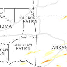
Oklahoma
| Local Time | Report Details |
|---|---|
| 2:24 PM CDT | Quarter sized hail reported near Battiest, OK, 68.4 miles E of Atoka, OK, quarter size hail reported near and just east of battiest. |
Texas
| Local Time | Report Details |
|---|---|
| 3:28 PM CDT | Golf Ball sized hail reported near Mount Pleasant, TX, 79.5 miles SW of Nashville, AR, social media post of hail near golf ball size north of mount pleasant texas. |
| 3:30 PM CDT | Ping Pong Ball sized hail reported near Mount Pleasant, TX, 77.2 miles SW of Nashville, AR, photo of ping pong size hail north of mount pleasant near the intersection of county road 3265 and county road 3250. |
| 4:07 PM CDT | Tree damage and tree limbs down in the copeland road and paluxy drive areas in south tyle in smith county TX, 74.1 miles NNW of Lufkin, TX |
| 4:25 PM CDT | Tree limbs down near grove club lake just south of whitehouse texa in smith county TX, 64.6 miles NNW of Lufkin, TX |
| 5:20 PM CDT | Trees down on hendricks lake rd and north hill s in rusk county TX, 47.3 miles WSW of Shreveport, LA |
| 5:26 PM CDT | Quarter sized hail reported near Rusk, TX, 46.6 miles NW of Lufkin, TX, quarter size hail measured in the maydelle community. |
| 6:06 PM CDT | Reports of trees down just east of laneville near fm road 2496 at county road 3162... fm road 2496 near fm road 1798... and along county road 316 in rusk county TX, 43.4 miles N of Lufkin, TX |
| 6:51 PM CDT | Golf Ball sized hail reported near Tenaha, TX, 48.4 miles SW of Shreveport, LA |
| 6:58 PM CDT | Quarter sized hail reported near Crockett, TX, 43.9 miles W of Lufkin, TX, nickel to quarter size hail in crockett. |
| 7:05 PM CDT | Quarter sized hail reported near Crockett, TX, 35 miles W of Lufkin, TX, quarter size hail in berea. |
| 7:08 PM CDT | Ping Pong Ball sized hail reported near Joaquin, TX, 46.7 miles SSW of Shreveport, LA, social media photo of ping pong size hail near joaquin from ksla tv. |
| 7:15 PM CDT | Hen Egg sized hail reported near Joaquin, TX, 43.4 miles SSW of Shreveport, LA, social media photos of hail at least 2 inches or larger just south of joaquin. |
Colorado
| Local Time | Report Details |
|---|---|
| 2:31 PM MDT | Report from mping: 1-inch tree limbs broke in arapahoe county CO, 11.1 miles SE of Denver, CO |
| 2:45 PM MDT | Report from mping: 1-inch tree limbs broke in denver county CO, 9.5 miles SW of Denver, CO |
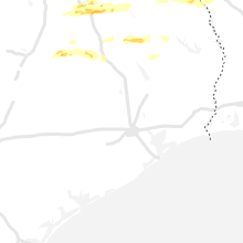
Arkansas
| Local Time | Report Details |
|---|---|
| 3:40 PM CDT | Ping Pong Ball sized hail reported near Ozan, AR, 8.8 miles SE of Nashville, AR, social media photo of hail up to ping pong size near the town of ozan arkansas. |
| 3:42 PM CDT | Golf Ball sized hail reported near Ozan, AR, 11.7 miles S of Nashville, AR, reports of hail up to golf ball size caused dents and cracked windshield near the columbus arkansas community. |
| 3:51 PM CDT | Hen Egg sized hail reported near Mc Caskill, AR, 12 miles E of Nashville, AR, several photos from social media of hail near 2 inches in mccaskill... arkansas. |
| 3:55 PM CDT | Ping Pong Ball sized hail reported near Blevins, AR, 16.3 miles ESE of Nashville, AR, em sent photo of ping pong size hail from the public in blevins... arkansas. |
| 5:01 PM CDT | Mesonet station up525 5.9 w parkin (upr in cross county AR, 35.4 miles WNW of Memphis, TN |
| 5:26 PM CDT | Quarter sized hail reported near Texarkana, AR, 39.3 miles S of Nashville, AR, quarter size hail reported in the genoa area. |
| 5:27 PM CDT | Golf Ball sized hail reported near Sheridan, AR, 31.1 miles SSW of Little Rock, AR, report of golf ball sized hail in sheridan... ar. |
| 6:22 PM CDT | Golf Ball sized hail reported near Stuttgart, AR, 53.9 miles ESE of Little Rock, AR, golf ball size hail reported 3 miles west of casscoe... ar. |
Kansas
| Local Time | Report Details |
|---|---|
| 4:17 PM CDT | Report from mping: 1-inch tree limbs broken; shingles blown of in stafford county KS, 67.6 miles SSE of Hays, KS |
Indiana
| Local Time | Report Details |
|---|---|
| 4:54 PM CDT | Quarter sized hail reported near Crown Point, IN, 39.1 miles SSE of Chicago, IL |
| 4:55 PM CDT | Quarter sized hail reported near Valparaiso, IN, 42 miles SE of Chicago, IL, photo shared of hail in valparaiso with the largest hailstones being approximately quarter sized. |
| 4:56 PM CDT | Quarter sized hail reported near Valparaiso, IN, 40.3 miles SE of Chicago, IL |
| 4:58 PM CDT | Quarter sized hail reported near Wanatah, IN, 49.6 miles SE of Chicago, IL |
| 4:58 PM CDT | Half Dollar sized hail reported near Wanatah, IN, 52 miles SE of Chicago, IL, corrects time of previous hail report from 3 e wanatah. |
| 5:05 PM CDT | Quarter sized hail reported near Kingsford Heights, IN, 56.2 miles ESE of Chicago, IL |
| 6:18 PM EDT | Ping Pong Ball sized hail reported near Walkerton, IN, 66.4 miles ESE of Chicago, IL, corrects time of previous hail report from walkerton. ping pong size hail reported. time estimated from radar. |
| 6:30 PM EDT | Ping Pong Ball sized hail reported near Lakeville, IN, 69 miles WNW of Fort Wayne, IN, photo on twitter of severe hail in lakeville... in. time estimated from radar. ping pong sized hail. |
| 6:30 PM EDT | Golf Ball sized hail reported near Lakeville, IN, 68.5 miles WNW of Fort Wayne, IN, photo on twitter of estimated golf ball sized hail at laville high school in lakeville... in. several vehicles have damage. time estimated from radar. |
| 6:35 PM EDT | Quarter sized hail reported near South Bend, IN, 70.3 miles WNW of Fort Wayne, IN, photo on twitter of hail on the south side of south bend. estimated quarter size hail. time estimated from radar. |
| 5:35 PM CDT | Half Dollar sized hail reported near Wanatah, IN, 52 miles SE of Chicago, IL |
| 6:35 PM EDT | Hen Egg sized hail reported near South Bend, IN, 70.3 miles WNW of Fort Wayne, IN, corrects previous hail report from gulivoire park. photo on twitter of hail on the south side of south bend. estimated up to 2 inch sized hail. time estimated from rada |
| 6:45 PM EDT | Quarter sized hail reported near Shipshewana, IN, 48.6 miles NNW of Fort Wayne, IN, time estimated from radar. report from facebook. |
| 7:00 PM EDT | Ping Pong Ball sized hail reported near Walkerton, IN, 66.4 miles ESE of Chicago, IL, ping pong size hail reported. time estimated from radar. |
| 7:00 PM EDT | Ping Pong Ball sized hail reported near Plymouth, IN, 65.9 miles WNW of Fort Wayne, IN, ping pong ball sized hail reported. time estimated from radar. |
| 7:03 PM EDT | Quarter sized hail reported near Lapaz, IN, 68.4 miles WNW of Fort Wayne, IN, quarter size hail reported near the intersection of church street and michigan road. |
| 7:26 PM EDT | Quarter sized hail reported near Elkhart, IN, 62 miles NW of Fort Wayne, IN, quarter size hail reported at the intersection of county road 6 and us-19. |
| 7:33 PM EDT | Half Dollar sized hail reported near Elkhart, IN, 62.4 miles NW of Fort Wayne, IN, at the intersection of county road 20 and sr 15. |
| 7:40 PM EDT | Half Dollar sized hail reported near Middlebury, IN, 51.9 miles NW of Fort Wayne, IN |
| 7:40 PM EDT | Quarter sized hail reported near Shipshewana, IN, 48.6 miles NNW of Fort Wayne, IN, corrects time of previous hail report from shipshewana. time estimated from radar. report from facebook. |
| 7:42 PM EDT | Quarter sized hail reported near Middlebury, IN, 50.6 miles NW of Fort Wayne, IN, quarter size hail reported at the intersection of cr 16 and cr 43. time estimated from radar. |
| 7:50 PM EDT | Golf Ball sized hail reported near Fremont, IN, 47.8 miles NNE of Fort Wayne, IN, report via facebook. |
| 7:52 PM EDT | Half Dollar sized hail reported near Fremont, IN, 46.8 miles NNE of Fort Wayne, IN |
| 8:00 PM EDT | Quarter sized hail reported near Fremont, IN, 47.1 miles NNE of Fort Wayne, IN |
| 9:36 PM EDT | Quarter sized hail reported near Boswell, IN, 79.3 miles NW of Indianapolis, IN |
| 9:38 PM EDT | Reports of numerous structures damaged along county road e 330 s from near atkinson east to the county line. corner of 2nd floor and nearly entire roof of new construct in benton county IN, 77.6 miles NW of Indianapolis, IN |
| 8:49 PM CDT | Reports of 6 semis flipped at southbound exit 201 on i-65. time estimated based on rada in jasper county IN, 81.4 miles SSE of Chicago, IL |
| 8:50 PM CDT | Structural damage reported at fbi buildings inc. time estimated based on rada in jasper county IN, 82.7 miles SSE of Chicago, IL |
| 9:50 PM EDT | Spotter reports vehicles blown over and damage in the median along i-65 mile markers 187-190... near sr-18 exi in white county IN, 75.5 miles NW of Indianapolis, IN |
| 8:53 PM CDT | Photo of 5 power poles either snapped or leaning due to win in lake county IN, 31.9 miles SSE of Chicago, IL |
| 8:53 PM CDT | Measured on personal weather statio in lake county IN, 41.5 miles SSE of Chicago, IL |
| 8:54 PM CDT | Penny size hail als in lake county IN, 37.5 miles SSE of Chicago, IL |
| 9:55 PM EDT | 2 homes destroyed and several damage in white county IN, 74.5 miles NW of Indianapolis, IN |
| 9:55 PM EDT | Two homes destroyed and damage to several other in white county IN, 73.5 miles NW of Indianapolis, IN |
| 8:56 PM CDT | Several instances of tree damage reported in crown point. fences also blown dow in lake county IN, 35 miles SSE of Chicago, IL |
| 9:56 PM EDT | Shingles and sheathing removed from garage. numerous trees damaged... some large trees downe in white county IN, 75.1 miles NW of Indianapolis, IN |
| 9:57 PM EDT | Large tree downe in white county IN, 77.8 miles NNW of Indianapolis, IN |
| 9:01 PM CDT | 129th and delaware sustained winds 50-55 mph e 65-70 gust in lake county IN, 34.8 miles SSE of Chicago, IL |
| 10:05 PM EDT | 62 mph wind gust recorded in round grove... in. building collapse in white county IN, 73.4 miles NW of Indianapolis, IN |
| 9:07 PM CDT | 76th and jackson st area. 6-7 homes with roofs peeled off over garages. debris scattered and wrapped around trees and poles... and trees down. potential tornado damag in lake county IN, 31.7 miles SSE of Chicago, IL |
| 9:10 PM CDT | Several trees and power lines downed across the north side of valparais in porter county IN, 41 miles SE of Chicago, IL |
| 9:11 PM CDT | 65 kt gust at kvp in porter county IN, 44 miles SE of Chicago, IL |
| 10:13 PM EDT | Corrects previous tstm wnd dmg report from 1 wsw crumstown. tree down. corrected tim in st. joseph county IN, 64.8 miles ESE of Chicago, IL |
| 9:18 PM CDT | Measured at mcyi in lmz745 county IN, 37.8 miles ESE of Chicago, IL |
| 9:19 PM CDT | Tree downed onto road. time estimated from rada in jasper county IN, 57.6 miles SSE of Chicago, IL |
| 10:20 PM EDT | Several homes damaged at 875w and 400 in cass county IN, 75.5 miles NNW of Indianapolis, IN |
| 10:20 PM EDT | Semi blown over on sr 16 at 1050 in cass county IN, 78.2 miles W of Fort Wayne, IN |
| 9:20 PM CDT | Trees downed east-northeast of fair oaks. time estimated from rada in jasper county IN, 58.6 miles SSE of Chicago, IL |
| 10:21 PM EDT | *** 7 inj *** tree onto van. preliminary report of 7 injuries... 5 mino in cass county IN, 74.4 miles WSW of Fort Wayne, IN |
| 9:22 PM CDT | Power poles also downed in the demotte are in jasper county IN, 52.9 miles SSE of Chicago, IL |
| 10:24 PM EDT | *** 2 fatal... 1 inj *** thunderstorm winds consistent with probable tornado. 2 fatalities and 1 injury and 1 person missing. time estimate in sullivan county IN, 56.4 miles ESE of Mattoon, IL |
| 10:30 PM EDT | Thunderstorm winds flattened 2 structures to basement. several other structures with roofs blown off near junction of benton tippecanoe and white counties. 1 inch hail in tippecanoe county IN, 69.1 miles NW of Indianapolis, IN |
| 9:35 PM CDT | Awos station kppo la port in la porte county IN, 51.4 miles ESE of Chicago, IL |
| 10:35 PM EDT | Observed at kcfj awo in montgomery county IN, 43.5 miles WNW of Indianapolis, IN |
| 10:35 PM EDT | Large tree snapped laing av in st. joseph county IN, 67.1 miles NW of Fort Wayne, IN |
| 10:40 PM EDT | Quarter sized hail reported near Darlington, IN, 39.4 miles WNW of Indianapolis, IN |
| 10:41 PM EDT | Thunderstorm winds snapped tops off of 20 trees and blew roof of of bar in clinton county IN, 40 miles NW of Indianapolis, IN |
| 9:45 PM CDT | Estimated on east side of evansvill in vanderburgh county IN, 5.3 miles ESE of Evansville, IN |
| 10:45 PM EDT | Tree across road. time estimated from rada in marshall county IN, 65.7 miles WNW of Fort Wayne, IN |
| 10:45 PM EDT | Barn destroyed. time estimated via rada in boone county IN, 35.7 miles NW of Indianapolis, IN |
| 10:45 PM EDT | Johnston road west of crumstown highway... road blocked due to downed tree. time estimated from rada in st. joseph county IN, 66.8 miles ESE of Chicago, IL |
| 10:48 PM EDT | Jaworskis market... 58413 crumstown hwy south bend... in 46619. sign blown over from wind gusts... friday evening. photo on twitter. time estimated from rada in st. joseph county IN, 71.8 miles E of Chicago, IL |
| 10:49 PM EDT | Tree dow in st. joseph county IN, 64.8 miles ESE of Chicago, IL |
| 10:49 PM EDT | Storm damage reported in miami county IN, 55.6 miles WSW of Fort Wayne, IN |
| 10:50 PM EDT | Reports of building collapse in north liberty. a building on n main street that suffered damage from a fire back in february was further damaged by strong winds friday in st. joseph county IN, 66.8 miles ESE of Chicago, IL |
| 10:53 PM EDT | Pea sized hail also reporte in owen county IN, 53.5 miles SW of Indianapolis, IN |
| 10:54 PM EDT | Tree across road. no information on health of tre in huntington county IN, 18.2 miles WSW of Fort Wayne, IN |
| 10:55 PM EDT | Tree across roa in fulton county IN, 70.8 miles W of Fort Wayne, IN |
| 11:10 PM EDT | Metal barn partially destroyed with pieces of metal thrown into nearby tree in elkhart county IN, 49.3 miles NW of Fort Wayne, IN |
| 11:10 PM EDT | Severe winds lasted 8 minutes 1110pm to 1118pm. 3 trees down. dime hai in owen county IN, 40 miles SW of Indianapolis, IN |
| 11:11 PM EDT | Quarter sized hail reported near Andrews, IN, 30.1 miles WSW of Fort Wayne, IN |
| 11:12 PM EDT | 2 ft diameter tree downed. powerlines downed and train railcars flipped ove in elkhart county IN, 46.9 miles NW of Fort Wayne, IN |
| 11:17 PM EDT | Several reports of power flashes observed near benton. power outages reported as wel in elkhart county IN, 45.6 miles NW of Fort Wayne, IN |
| 11:18 PM EDT | Several trees downed across southern part of count in fulton county IN, 61.3 miles W of Fort Wayne, IN |
| 11:19 PM EDT | Measured gust 64 mp in kosciusko county IN, 37 miles WNW of Fort Wayne, IN |
| 11:20 PM EDT | Report on twitter of a barn fire ongoing at 16000 osborne road as of 11:20 pm et. unsure of caus in st. joseph county IN, 65.1 miles WNW of Fort Wayne, IN |
| 11:23 PM EDT | Thunderstorm winds downed numerous large trees and snapped power poles. time estimate in morgan county IN, 36.1 miles SW of Indianapolis, IN |
| 11:23 PM EDT | Winds downed multiple trees with considerable home damage between martinsville and paragon. also estimated 60 mph winds in parago in morgan county IN, 30.9 miles SW of Indianapolis, IN |
| 11:25 PM EDT | Damage to several building in grant county IN, 54.2 miles NNE of Indianapolis, IN |
| 11:25 PM EDT | 2 homes partially collapsed and trees down at county roads 400 west and 300 south. building collapsed at county roads 750 west and 5145 south. possible funnel cloud at in howard county IN, 45.8 miles N of Indianapolis, IN |
| 11:29 PM EDT | Privacy fence destroyed and window broke in morgan county IN, 21.8 miles SW of Indianapolis, IN |
| 11:30 PM EDT | Mesonet station pdu05 northeast purdue agricultural c in whitley county IN, 15.9 miles W of Fort Wayne, IN |
| 11:30 PM EDT | Storm damage reported in allen county IN, 3.1 miles N of Fort Wayne, IN |
| 11:30 PM EDT | 5 semis blown over. damage to commercial structure. tree on home on nearby doty rd. vehicles blown into yar in allen county IN, 6 miles NE of Fort Wayne, IN |
| 11:31 PM EDT | Storm damage reported in allen county IN, 7.8 miles SSW of Fort Wayne, IN |
| 11:33 PM EDT | Thunderstorm winds consistent with probable tornado destroyed multiple homes on both sides of us highway 31 with warehouse damage. time estimate in johnson county IN, 16.1 miles SSE of Indianapolis, IN |
| 11:34 PM EDT | Asos station keye indianapolis (eagle creek in marion county IN, 9.1 miles WNW of Indianapolis, IN |
| 11:35 PM EDT | Damage to several building in grant county IN, 48.5 miles SSW of Fort Wayne, IN |
| 11:36 PM EDT | Storm damage reported in marion county IN, 8.1 miles WSW of Indianapolis, IN |
| 11:40 PM EDT | Storm damage reported in hendricks county IN, 10.1 miles W of Indianapolis, IN |
| 11:40 PM EDT | Numerous reports of large trees and powerlines downed. also received a report of vehicles blown off roa in allen county IN, 13.1 miles NE of Fort Wayne, IN |
| 11:45 PM EDT | Large tree downe in steuben county IN, 39 miles N of Fort Wayne, IN |
| 11:50 PM EDT | Winds at onset of thunderstorm. reports of numerous power poles and lines down across madison county. time estimate in madison county IN, 31.7 miles NE of Indianapolis, IN |
| 11:54 PM EDT | Storm damage reported in steuben county IN, 43.1 miles N of Fort Wayne, IN |
| 11:55 PM EDT | Storm damage reported in noble county IN, 28.5 miles NNW of Fort Wayne, IN |
| 11:55 PM EDT | Thunderstorm winds downed gas station overhanging roof. time estimate in shelby county IN, 24.9 miles ESE of Indianapolis, IN |
| 12:00 AM EDT | Barn roof blown off. roof of house also partially blown of in wells county IN, 33.2 miles SSW of Fort Wayne, IN |
| 12:00 AM EDT | Smith field airport awo in allen county IN, 5.2 miles NNW of Fort Wayne, IN |
| 12:00 AM EDT | Limbs and powerlines downe in wells county IN, 33 miles SSW of Fort Wayne, IN |
| 12:00 AM EDT | Storm damage reported in wells county IN, 23.2 miles S of Fort Wayne, IN |
| 12:00 AM EDT | Power flashes. 5 miles north of montpelier looking se at 12:00 am. video on twitte in wells county IN, 32.2 miles SSW of Fort Wayne, IN |
| 12:05 AM EDT | Quarter sized hail reported near Albany, IN, 54 miles S of Fort Wayne, IN |
| 12:06 AM EDT | Tree down at intersection of sr 129 and sr 350. time from radar in ripley county IN, 38 miles W of Cincinnati, OH |
| 12:13 AM EDT | Storm damage reported in ripley county IN, 40.7 miles W of Cincinnati, OH |
| 12:15 AM EDT | Multiple reports of damage throughout jay count in jay county IN, 44.3 miles S of Fort Wayne, IN |
| 12:16 AM EDT | Several large trees reported down. time from radar in ripley county IN, 33.1 miles W of Cincinnati, OH |
| 12:22 AM EDT | Several large trees reported down. time from radar in ripley county IN, 39.1 miles W of Cincinnati, OH |
Wisconsin
| Local Time | Report Details |
|---|---|
| 5:47 PM CDT | Quarter sized hail reported near La Crosse, WI, 5.2 miles E of La Crosse, WI |
| 5:49 PM CDT | Half Dollar sized hail reported near Arkdale, WI, 70.1 miles ENE of La Crosse, WI |
| 6:30 PM CDT | Sign damage note in grant county WI, 68.3 miles WSW of Madison, WI |
| 6:45 PM CDT | Reports of a farm shed down and powerlines dow in iowa county WI, 53.8 miles WSW of Madison, WI |
| 6:50 PM CDT | Reports of multiple trees dow in lafayette county WI, 53.6 miles WSW of Madison, WI |
| 6:56 PM CDT | Storm damage reported in grant county WI, 62.2 miles WSW of Madison, WI |
| 7:26 PM CDT | Reports of multiple trees down and powerlines down across eastern and southeast green co. time estimated from rada in green county WI, 31.3 miles S of Madison, WI |
| 7:46 PM CDT | Delayed report via social media of a collapsed garag in rock county WI, 42.5 miles SSE of Madison, WI |
| 7:50 PM CDT | Delayed report. time estimated via radar. a couple of downed trees and a fence gate... which was closed and latched... was taken off its hinges and thrown about 25 feet in rock county WI, 42.2 miles SSE of Madison, WI |
Michigan
| Local Time | Report Details |
|---|---|
| 7:30 PM EDT | Quarter sized hail reported near Sturgis, MI, 52.7 miles NNW of Fort Wayne, IN |
| 7:55 PM EDT | Ping Pong Ball sized hail reported near Sturgis, MI, 51.9 miles NNW of Fort Wayne, IN, up to ping pong size hail reported at the intersection of bogen road and south centreville street sw of sturgis. |
| 7:55 PM EDT | Golf Ball sized hail reported near Sturgis, MI, 51.9 miles NNW of Fort Wayne, IN, corrects previous hail report from 2 sw sturgis. up to golf ball hail reported at the intersection of bogen road and south centreville street sw of sturgis. spotter rep |
| 8:00 PM EDT | Quarter sized hail reported near Sturgis, MI, 52.7 miles NNW of Fort Wayne, IN |
| 8:19 PM EDT | Quarter sized hail reported near Kalamazoo, MI, 40.5 miles S of Grand Rapids, MI |
| 9:04 PM EDT | Quarter sized hail reported near Battle Creek, MI, 47.3 miles SE of Grand Rapids, MI, one inch hail near pennfield. |
| 11:02 PM EDT | M-139 (niles road) at tanglewood trail closed due to a downed tree blocking the roadway. both north and south bound lanes blocke in berrien county MI, 62.9 miles E of Chicago, IL |
| 11:44 PM EDT | Trained spotter estimates wind gusts of 60 mph at olds rd and union city r in branch county MI, 67.6 miles SSE of Grand Rapids, MI |
Mississippi
| Local Time | Report Details |
|---|---|
| 7:52 PM CDT | Several trees were knocked down with one tree on a car on horn lake road north of dean roa in desoto county MS, 22.1 miles S of Memphis, TN |
| 8:10 PM CDT | Some roof damage and trees down near the intersection of highway 304 and scenic lan in tunica county MS, 39 miles SW of Memphis, TN |
| 1:27 AM CDT | Part of roof torn off of cooper tir in lee county MS, 53.1 miles N of Starkville, MS |
Kentucky
| Local Time | Report Details |
|---|---|
| 9:40 PM CDT | Wind gusts estimated at 60mph in southwest murra in calloway county KY, 33.3 miles NNE of Mc Kenzie, TN |
| 9:41 PM CDT | Quarter sized hail reported near Henderson, KY, 6.7 miles S of Evansville, IN, report from mping: quarter (1.00 in.). |
| 11:00 PM CDT | Damage to the mixer restaurant in downtown hopkinsville. the the third story of the building collapse in christian county KY, 61.5 miles NW of Nashville, TN |
| 12:25 AM EDT | Retired nws employee reported an estimated wind gust near 60 mp in jefferson county KY, 16.7 miles NNE of Louisville, KY |
| 12:27 AM EDT | Klou reported a thunderstorm wind gust of 60 mp in jefferson county KY, 17 miles N of Louisville, KY |
| 12:55 AM EDT | Via social media - images of a large tree blown onto a car on st. james court in louisvill in jefferson county KY, 16.9 miles N of Louisville, KY |
| 1:23 AM EDT | Tree down over road. time from radar in bracken county KY, 38.1 miles SE of Cincinnati, OH |
| 1:45 AM EDT | Storm damage reported in bracken county KY, 37.2 miles SE of Cincinnati, OH |
| 2:40 AM EDT | Huge tree down blocking the roadway... state route 20 in greenup county KY, 63.5 miles W of Charleston, WV |
Ohio
| Local Time | Report Details |
|---|---|
| 10:42 PM EDT | Half Dollar sized hail reported near Madison, OH, 38 miles NE of Cleveland, OH, report from mping: half dollar (1.25 in.). |
| 10:57 PM EDT | Half Dollar sized hail reported near Geneva, OH, 42.6 miles ENE of Cleveland, OH |
| 11:31 PM EDT | Storm damage reported in defiance county OH, 39 miles ENE of Fort Wayne, IN |
| 12:23 AM EDT | Amatuer radio reports town of ney has no powe in defiance county OH, 36.8 miles NE of Fort Wayne, IN |
| 12:30 AM EDT | Semi blown ove in van wert county OH, 29.5 miles ESE of Fort Wayne, IN |
| 12:30 AM EDT | Semi blown ove in van wert county OH, 34 miles SE of Fort Wayne, IN |
| 12:30 AM EDT | 2 large trees downe in henry county OH, 56.1 miles ENE of Fort Wayne, IN |
| 12:31 AM EDT | Several animal barns damaged near park road and fort recovery. time front radar in mercer county OH, 47.4 miles SSE of Fort Wayne, IN |
| 12:35 AM EDT | Lucas county sheriff dispatch reports multiple trees and power lines down. reports that a tree fell onto a house north of maumee... o in lucas county OH, 84.8 miles ENE of Fort Wayne, IN |
| 12:35 AM EDT | Tree and power pole reported down at park road west of sr 49 in mercer county OH, 47.6 miles SSE of Fort Wayne, IN |
| 12:45 AM EDT | Wood county sheriff dispatch reports multiple wires down near westo in wood county OH, 70 miles ENE of Fort Wayne, IN |
| 12:50 AM EDT | Multiple power poles and trees down. barn collapse in auglaize county OH, 47.6 miles SE of Fort Wayne, IN |
| 12:55 AM EDT | Storm damage reported in putnam county OH, 58.5 miles E of Fort Wayne, IN |
| 1:00 AM EDT | Three trees downed along with a few powerline in putnam county OH, 60.2 miles E of Fort Wayne, IN |
| 1:00 AM EDT | Several grain bins torn down... medium sized brick building partially torn dow in auglaize county OH, 61.6 miles SE of Fort Wayne, IN |
| 1:02 AM EDT | Some large tree branches down and some structural damage to a bar in allen county OH, 62.9 miles ESE of Fort Wayne, IN |
| 1:05 AM EDT | Significant damage to a shed and a carport lifted off groun in allen county OH, 62.9 miles ESE of Fort Wayne, IN |
| 1:07 AM EDT | Large tree branches downed. time estimated from rada in allen county OH, 64 miles ESE of Fort Wayne, IN |
| 1:09 AM EDT | Large tree down. time from radar in hardin county OH, 70.2 miles ESE of Fort Wayne, IN |
| 1:09 AM EDT | Damage to hog barn along with a few power lines down. time estimated from rada in allen county OH, 65.7 miles ESE of Fort Wayne, IN |
| 1:09 AM EDT | Power pole snapped in half. time from radar in clermont county OH, 18.7 miles ENE of Cincinnati, OH |
| 1:10 AM EDT | Tree down over road. time from radar in clermont county OH, 23.4 miles SE of Cincinnati, OH |
| 1:10 AM EDT | 6 inch diameter tree down. time from radar in miami county OH, 63.7 miles W of Columbus, OH |
| 1:10 AM EDT | Tree down. time from radar in hardin county OH, 67.9 miles NW of Columbus, OH |
| 1:11 AM EDT | Ottawa county sheriff dispatch reports trees and power lines down across the western portion of the county. a personal weather station reported a 78.7 mph wind gust in in ottawa county OH, 85.6 miles W of Cleveland, OH |
| 1:13 AM EDT | Small trees down... barn and fence destroye in miami county OH, 63.9 miles W of Columbus, OH |
| 1:17 AM EDT | Storm damage reported in montgomery county OH, 56.8 miles NNE of Cincinnati, OH |
| 1:20 AM EDT | Hancock county sheriff dispatch reports multiple trees and power lines dow in hancock county OH, 75.7 miles E of Fort Wayne, IN |
| 1:39 AM EDT | Large pine tree down in warren county OH, 27.5 miles NE of Cincinnati, OH |
| 1:40 AM EDT | Wyandot county emergency manager reports multiple trees and power lines down in upper sandusky... o in wyandot county OH, 61.6 miles NNW of Columbus, OH |
| 1:40 AM EDT | Marion county sheriffs dispatch reports power line down near la rue... o in marion county OH, 47.9 miles NNW of Columbus, OH |
| 1:43 AM EDT | Tree down over road. time from radar in warren county OH, 29.3 miles ENE of Cincinnati, OH |
| 1:50 AM EDT | Recorded at nws office wilmingto in clinton county OH, 42.6 miles ENE of Cincinnati, OH |
| 1:55 AM EDT | Crawford county oh sheriffs dispatch reports damage to a barn in holmes townshi in crawford county OH, 60.6 miles N of Columbus, OH |
| 2:05 AM EDT | Report from mping: 3-inch tree limbs broken; power poles broke in crawford county OH, 69.3 miles N of Columbus, OH |
| 2:15 AM EDT | Morrow county sheriffs dispatch reports trees down near route 42 in mount gilea in morrow county OH, 41.6 miles NNE of Columbus, OH |
| 2:17 AM EDT | Tree down over road. time from radar in highland county OH, 39.5 miles E of Cincinnati, OH |
| 2:20 AM EDT | Richland county sheriffs dispatch reports multiple power lines and trees down. also reports that half of a roof was blown off building and damage to porches of home in richland county OH, 63.1 miles NNE of Columbus, OH |
| 2:22 AM EDT | Asos station klpr lorain elyria measured a 61 kt thunderstorm wind gus in lorain county OH, 27.6 miles WSW of Cleveland, OH |
| 2:30 AM EDT | Ashland county sheriff dispatch reports large trees down near ashland... o in ashland county OH, 57.3 miles SW of Cleveland, OH |
| 2:41 AM EDT | Asos station kbkl cleveland measured a 61 kt marine thunderstorm wind gus in cuyahoga county OH, 1.2 miles NNE of Cleveland, OH |
| 2:41 AM EDT | Asos station kbkl cleveland measured a 61 kt marine thunderstorm wind gus in cuyahoga county OH, 1.2 miles NNE of Cleveland, OH |
| 2:45 AM EDT | Tree into power line in perry county OH, 53.8 miles ESE of Columbus, OH |
| 2:46 AM EDT | Corrects previous tstm wnd gst report from 2 sse parma. weather station in se parma reported a 54 kt thunderstorm wind gust. corrected for tim in cuyahoga county OH, 10.7 miles S of Cleveland, OH |
| 2:57 AM EDT | Weather station in se parma reported a 54 kt thunderstorm wind gus in cuyahoga county OH, 10.7 miles S of Cleveland, OH |
| 3:00 AM EDT | C-man station faio1 fairport... oh measured a 51 kt marine thunderstorm wind gus in lake county OH, 27.6 miles NE of Cleveland, OH |
| 3:10 AM EDT | C-man station gelo1 1 w geneva-on-the-lake reported a 53 kt marine thunderstorm wind gus in lez147 county OH, 44.6 miles ENE of Cleveland, OH |
Louisiana
| Local Time | Report Details |
|---|---|
| 10:25 PM CDT | A picture was posted to social media of a large limb that broke through a kitchen window of a home on caples road in west monro in ouachita county LA, 30 miles SW of Bastrop, LA |
| 10:25 PM CDT | A tree was downed onto a home on williams harris road in west monro in ouachita county LA, 29.1 miles SW of Bastrop, LA |
| 10:26 PM CDT | Reports of extensive wind damage to trees and powerlines across bienville parish... with the sheriff department receiving several reports between the town of castor and in bienville county LA, 37.7 miles ESE of Shreveport, LA |
| 10:54 PM CDT | Sheriff department reports many trees down in the quitman are in jackson county LA, 55.5 miles WSW of Bastrop, LA |
| 10:58 PM CDT | Quarter sized hail reported near Quitman, LA, 55.5 miles WSW of Bastrop, LA, a picture was posted to social media of quarter size hail that covered the ground in quitman. |
| 11:10 PM CDT | Trees and power lines were downed near the jackson/lincoln parish line south of choudran in jackson county LA, 42 miles WSW of Bastrop, LA |
| 11:15 PM CDT | Trees and power lines were downed in the cartwright communit in jackson county LA, 38.7 miles WSW of Bastrop, LA |
| 11:25 PM CDT | Corrects previous tstm wnd dmg report from 6 sw brownsville-bawcom. a picture was posted to social media of a large limb that broke through a kitchen window of a home o in ouachita county LA, 30 miles SW of Bastrop, LA |
| 11:25 PM CDT | Corrects previous tstm wnd dmg report from 6 sw claiborne. a tree was downed onto a home on williams harris road in west monro in ouachita county LA, 29.1 miles SW of Bastrop, LA |
| 11:36 PM CDT | A couple of trees were downed on highway 15 (winnsboro road in ouachita county LA, 24 miles SSW of Bastrop, LA |
Alabama
| Local Time | Report Details |
|---|---|
| 2:47 AM CDT | Trees uprooted and power lines downed in haleyvill in winston county AL, 39.4 miles S of Florence, AL |
| 4:53 AM CDT | Trees and powerlines down near alexander rd and patterson st. possible tornad in etowah county AL, 60.8 miles NE of Birmingham, AL |
Georgia
| Local Time | Report Details |
|---|---|
| 7:05 AM EDT | Trees down at spring place rd and hwy 14 in bartow county GA, 48 miles NNW of Atlanta, GA |
| 7:23 AM EDT | Trees down at sutallee ridge trace and white roa in cherokee county GA, 35.9 miles NNW of Atlanta, GA |
| 7:23 AM EDT | Trees down at lower burris rd and land r in cherokee county GA, 40.5 miles N of Atlanta, GA |
Connect with Interactive Hail Maps