

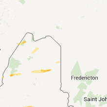
Hail Map for Wednesday, June 1, 2011

Number of Impacted Households on 6/1/2011
0
Impacted by 1" or Larger Hail
0
Impacted by 1.75" or Larger Hail
0
Impacted by 2.5" or Larger Hail
Square Miles of Populated Area Impacted on 6/1/2011
0
Impacted by 1" or Larger Hail
0
Impacted by 1.75" or Larger Hail
0
Impacted by 2.5" or Larger Hail


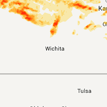


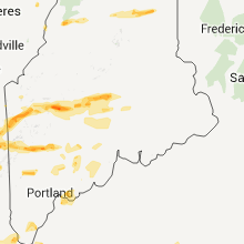


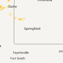


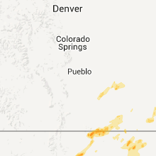


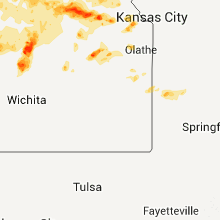
Cities Most Affected by Hail Storms of 6/1/2011
| Hail Size | Demographics of Zip Codes Affected | ||||||
|---|---|---|---|---|---|---|---|
| City | Count | Average | Largest | Pop Density | House Value | Income | Age |
| Abilene, KS | 5 | 2.70 | 4.50 | 32 | $69k | $37.1k | 42.0 |
| Paradise, KS | 4 | 2.25 | 2.75 | 1 | $36k | $30.8k | 50.0 |
| Osage City, KS | 4 | 1.81 | 2.00 | 27 | $72k | $35.6k | 42.1 |
| Norton, KS | 4 | 1.81 | 2.00 | 10 | $55k | $31.1k | 42.6 |
| Oxford, NE | 4 | 1.75 | 1.75 | 3 | $40k | $32.2k | 45.5 |
| Dorrance, KS | 3 | 2.08 | 2.75 | 1 | $16k | $31.5k | 51.3 |
| Keene, NH | 3 | 1.83 | 2.00 | 387 | $103k | $37.4k | 35.4 |
| West Dover, VT | 2 | 2.00 | 2.00 | 10 | $163k | $43.3k | 50.2 |
| Sylvan Grove, KS | 2 | 1.88 | 2.00 | 3 | $37k | $28.9k | 48.4 |
| Basehor, KS | 2 | 1.75 | 1.75 | 239 | $122k | $60.1k | 39.8 |
| Maxwell, NE | 2 | 1.75 | 1.75 | 1 | $52k | $32.3k | 41.6 |
| Las Vegas, NM | 2 | 1.75 | 1.75 | 11 | $89k | $25.9k | 38.7 |
| Emmett, KS | 1 | 2.75 | 2.75 | 5 | $60k | $39.8k | 29.7 |
| Eagle Bridge, NY | 1 | 2.75 | 2.75 | 46 | $92k | $42.7k | 43.7 |
| Saratoga Springs, NY | 1 | 2.75 | 2.75 | 547 | $132k | $46.5k | 41.1 |
| Cozad, NE | 1 | 2.75 | 2.75 | 23 | $61k | $34.0k | 40.3 |
| New Portland, ME | 1 | 2.75 | 2.75 | 2 | $59k | $26.3k | 49.7 |
| Kingfield, ME | 1 | 2.75 | 2.75 | 13 | $84k | $32.9k | 48.3 |
| Canton, KS | 1 | 2.75 | 2.75 | 8 | $72k | $36.9k | 42.7 |
| Stockton, KS | 1 | 2.00 | 2.00 | 5 | $41k | $31.2k | 46.6 |
| Belleville, KS | 1 | 2.00 | 2.00 | 16 | $46k | $30.2k | 51.0 |
| Neversink, NY | 1 | 2.00 | 2.00 | 51 | $89k | $38.2k | 40.6 |
| Natoma, KS | 1 | 2.00 | 2.00 | 2 | $19k | $27.0k | 45.6 |
| Adams, MA | 1 | 2.00 | 2.00 | 348 | $97k | $33.1k | 44.5 |
| Millbury, MA | 1 | 2.00 | 2.00 | 855 | $143k | $51.4k | 42.0 |
| Sturbridge, MA | 1 | 2.00 | 2.00 | 221 | $145k | $58.0k | 41.9 |
| Alvord, IA | 1 | 1.75 | 1.75 | 10 | $45k | $44.6k | 33.8 |
| Tekamah, NE | 1 | 1.75 | 1.75 | 17 | $71k | $36.5k | 45.0 |
| Belchertown, MA | 1 | 1.75 | 1.75 | 273 | $145k | $52.4k | 41.1 |
| Bethel, ME | 1 | 1.75 | 1.75 | 12 | $98k | $33.5k | 43.7 |
| Agra, KS | 1 | 1.75 | 1.75 | 3 | $23k | $27.9k | 48.6 |
| Hill City, KS | 1 | 1.75 | 1.75 | 7 | $46k | $31.3k | 48.4 |
| Gardner, MA | 1 | 1.75 | 1.75 | 817 | $106k | $37.3k | 40.7 |
| White Sulphur Springs, NY | 1 | 1.75 | 1.75 | 19 | $87k | $24.9k | 45.0 |
| Gypsum, KS | 1 | 1.75 | 1.75 | 4 | $65k | $39.7k | 43.4 |
| Logan, KS | 1 | 1.75 | 1.75 | 2 | $35k | $29.3k | 45.7 |
| Elm Creek, NE | 1 | 1.75 | 1.75 | 6 | $76k | $36.9k | 38.1 |
| Brick, NJ | 1 | 1.75 | 1.75 | 3190 | $137k | $53.8k | 43.7 |
| Waldo, KS | 1 | 1.75 | 1.75 | 1 | $10k | $29.7k | 45.0 |
| Roxbury, KS | 1 | 1.75 | 1.75 | 0 | $0k | $0.0k | 0.0 |
| Schuylerville, NY | 1 | 1.75 | 1.75 | 136 | $85k | $40.2k | 38.8 |
| Bryant Pond, ME | 1 | 1.75 | 1.75 | 20 | $79k | $35.6k | 45.8 |
| Partlow, VA | 1 | 1.75 | 1.75 | 85 | $116k | $43.5k | 37.7 |
| Campton, NH | 1 | 1.75 | 1.75 | 33 | $104k | $37.2k | 44.3 |
| Lenora, KS | 1 | 1.75 | 1.75 | 1 | $30k | $31.7k | 50.0 |
| Beaver City, NE | 1 | 1.75 | 1.75 | 3 | $33k | $28.4k | 48.5 |
| Florence, MA | 1 | 1.75 | 1.75 | 596 | $138k | $47.1k | 45.0 |
| Tonganoxie, KS | 1 | 1.75 | 1.75 | 94 | $107k | $50.8k | 36.9 |
| Monson, MA | 1 | 1.75 | 1.75 | 182 | $133k | $52.2k | 43.2 |
| Guilford, ME | 1 | 1.75 | 1.75 | 12 | $62k | $28.0k | 46.7 |
| Alton, KS | 1 | 1.75 | 1.75 | 2 | $15k | $33.2k | 48.8 |
| Petersburg, ND | 1 | 1.75 | 1.75 | 1 | $52k | $31.8k | 48.3 |
| Harwood, MO | 1 | 1.75 | 1.75 | 12 | $18k | $26.2k | 35.9 |
| Newfane, VT | 1 | 1.75 | 1.75 | 23 | $103k | $44.3k | 47.3 |
| Holdrege, NE | 1 | 1.75 | 1.75 | 30 | $72k | $37.2k | 43.2 |
| Hinsdale, MA | 1 | 1.75 | 1.75 | 39 | $109k | $42.5k | 45.8 |
| Pleasanton, NE | 1 | 1.75 | 1.75 | 5 | $74k | $40.5k | 41.6 |
| Beverly Hills, FL | 1 | 1.75 | 1.75 | 684 | $69k | $29.9k | 56.8 |
| Homer, NE | 1 | 1.75 | 1.75 | 4 | $86k | $43.1k | 39.0 |
| Saint Marys, KS | 1 | 1.75 | 1.75 | 62 | $80k | $40.2k | 24.7 |
| Upper Marlboro, MD | 1 | 1.75 | 1.75 | 616 | $155k | $73.6k | 38.9 |
| Danbury, NE | 1 | 1.75 | 1.75 | 3 | $27k | $35.5k | 45.5 |
| East Dover, VT | 1 | 1.75 | 1.75 | 13 | $119k | $44.6k | 47.3 |
Hail and Wind Damage Spotted on 6/1/2011
Filter by Report Type:Hail ReportsWind Reports
States Impacted
New Hampshire, Massachusetts, Maine, New York, Pennsylvania, Vermont, Florida, Kansas, New Mexico, South Carolina, North Carolina, Virginia, New Jersey, Nebraska, Connecticut, Colorado, Georgia, Maryland, South Dakota, Iowa, Missouri, North Dakota, Oklahoma, TexasNew Hampshire
| Local Time | Report Details |
|---|---|
| 12:18 PM UTC | Quarter sized hail reported near Jackson, NH, 56.8 miles NW of Portland, ME |
| 12:30 PM UTC | Quarter sized hail reported near Raymond, NH, 63.2 miles SW of Portland, ME |
| 12:35 PM UTC | Quarter sized hail reported near Hampstead, NH, 71.7 miles SW of Portland, ME |
| 12:35 PM UTC | Quarter sized hail reported near Raymond, NH, 63.2 miles SW of Portland, ME |
| 12:35 PM UTC | Quarter sized hail reported near Salem, NH, 67.6 miles N of Providence, RI |
| 12:36 PM UTC | Quarter sized hail reported near Londonderry, NH, 70.2 miles N of Providence, RI |
| 12:51 PM UTC | Quarter sized hail reported near Dover, NH, 45.9 miles SW of Portland, ME, strong thunderstorm... pea sized to 1 inch hail... no wind... heavy rain |
| 6:30 PM UTC | Quarter sized hail reported near Rumney, NH, 78.5 miles W of Portland, ME |
| 6:30 PM UTC | Quarter sized hail reported near Jefferson, NH, 82 miles NW of Portland, ME |
| 6:30 PM UTC | Trees down on wires route 3. traffic stoppe in coos county NH, 79.6 miles E of Burlington, VT |
| 6:43 PM UTC | Golf Ball sized hail reported near Campton, NH, 70.1 miles WNW of Portland, ME |
| 6:58 PM UTC | Quarter sized hail reported near Berlin, NH, 72.8 miles NW of Portland, ME |
| 7:03 PM UTC | Quarter sized hail reported near Errol, NH, 89 miles NNW of Portland, ME |
| 7:09 PM UTC | Quarter sized hail reported near Sandwich, NH, 58.1 miles WNW of Portland, ME |
| 7:14 PM UTC | Quarter sized hail reported near Keene, NH, 84.7 miles E of Schenectady, NY, ham radio |
| 7:16 PM UTC | Golf Ball sized hail reported near Keene, NH, 83.8 miles E of Schenectady, NY |
| 7:20 PM UTC | Quarter sized hail reported near Keene, NH, 84.7 miles E of Schenectady, NY |
| 7:21 PM UTC | Ping Pong Ball sized hail reported near Keene, NH, 84.7 miles E of Schenectady, NY, ham radio |
| 7:26 PM UTC | Golf Ball sized hail reported near Keene, NH, 83.8 miles E of Schenectady, NY |
| 11:43 PM UTC | Hen Egg sized hail reported near Keene, NH, 84.7 miles E of Schenectady, NY |
Massachusetts
| Local Time | Report Details |
|---|---|
| 1:00 PM UTC | Quarter sized hail reported near North Reading, MA, 54.9 miles NNE of Providence, RI, ham radio...from hillview country club |
| 6:45 PM UTC | Quarter sized hail reported near Pittsfield, MA, 42.8 miles SE of Schenectady, NY |
| 6:45 PM UTC | Hen Egg sized hail reported near Adams, MA, 43.6 miles ESE of Schenectady, NY |
| 7:00 PM UTC | Quarter sized hail reported near Pittsfield, MA, 42.8 miles SE of Schenectady, NY |
| 7:15 PM UTC | Ping Pong Ball sized hail reported near Becket, MA, 55.1 miles SE of Schenectady, NY |
| 7:23 PM UTC | Trees down on route 116 and hillside road in franklin county MA, 70.7 miles ESE of Schenectady, NY |
| 7:23 PM UTC | Trees down on route 116 at hillside road in the southern part of deerfiel in franklin county MA, 70.7 miles ESE of Schenectady, NY |
| 7:30 PM UTC | Golf Ball sized hail reported near Hinsdale, MA, 48.7 miles ESE of Schenectady, NY |
| 7:32 PM UTC | Quarter sized hail reported near Huntington, MA, 67 miles SE of Schenectady, NY |
| 7:40 PM UTC | Wires dow in berkshire county MA, 48.7 miles ESE of Schenectady, NY |
| 7:45 PM UTC | Half Dollar sized hail reported near Northampton, MA, 72.2 miles WNW of Providence, RI |
| 7:46 PM UTC | Half Dollar sized hail reported near Northampton, MA, 72.2 miles WNW of Providence, RI, ham radio |
| 7:50 PM UTC | Golf Ball sized hail reported near Northampton, MA, 72.4 miles ESE of Schenectady, NY, per fire chief via relayed media |
| 7:58 PM UTC | Tree down on car on walnut st in hampshire county MA, 72.4 miles ESE of Schenectady, NY |
| 8:10 PM UTC | Golf Ball sized hail reported near Belchertown, MA, 59.8 miles WNW of Providence, RI |
| 8:15 PM UTC | Trees and wires down on bay stree in hampshire county MA, 70.2 miles WNW of Providence, RI |
| 8:20 PM UTC | Trees and utility poles down on shaker road and union street. propane gas tank blown over and trees down on punpousett roa in hampden county MA, 72.8 miles WNW of Providence, RI |
| 8:27 PM UTC | Quarter sized hail reported near Chicopee, MA, 65.7 miles WNW of Providence, RI, ham radio |
| 8:32 PM UTC | Mcduffy school on ames hill road received significant damage. tractor trailer blown over on memorial bridge. several homes destroyed on allen street and broadwa in hampden county MA, 61.6 miles WNW of Providence, RI |
| 8:32 PM UTC | Multiple trees and wires down on main street and union stree in hampden county MA, 61.6 miles WNW of Providence, RI |
| 8:32 PM UTC | Route 5 from memorial bridge to north end bridge ... trees and wires down. roosevelt avenue ... house with roofs and other parts of homes blown off around cathedral hig in hampden county MA, 61.6 miles WNW of Providence, RI |
| 8:32 PM UTC | Tree down on house on hill street. tree down on car on union street. roof off of house along wilcox street near main street. three story building collapse on wilcox str in hampden county MA, 67 miles WNW of Providence, RI |
| 8:46 PM UTC | Golf Ball sized hail reported near Monson, MA, 50.5 miles WNW of Providence, RI, ham radio |
| 8:46 PM UTC | Numerous trees and wires down on waide road. six homes reported to be damaged. police department roof blown off and antenna tower collapsed. minor structural damage at in hampden county MA, 50 miles WNW of Providence, RI |
| 9:00 PM UTC | Quarter sized hail reported near Wilbraham, MA, 56.3 miles WNW of Providence, RI, ham radio |
| 9:00 PM UTC | Automotive building has been destroyed with trees down and trees debarked on holland roa in hampden county MA, 45.4 miles WNW of Providence, RI |
| 9:00 PM UTC | Trees and wires down near valley green campgroun in hampden county MA, 45.4 miles WNW of Providence, RI |
| 9:10 PM UTC | Multiple trees and wires down on the 6700 block on charlton road and the 700 block of worcester street. multiple planes flipped at southbridge airport. hanger and sever in worcester county MA, 36.4 miles WNW of Providence, RI |
| 9:10 PM UTC | Trees down blocking sturbridge parkway ... road impassable. trees down also on airport roa in worcester county MA, 36.4 miles WNW of Providence, RI |
| 9:17 PM UTC | Large trees down throughout tow in hampden county MA, 41.1 miles WNW of Providence, RI |
| 9:22 PM UTC | One to two foot diameter trees down on route 15. trees down in the village portion of sturbridge. large highway sign on i-84 on exit 2 blown over. multiple cars blown o in worcester county MA, 38.4 miles WNW of Providence, RI |
| 9:29 PM UTC | Hen Egg sized hail reported near Sturbridge, MA, 39.7 miles WNW of Providence, RI, ham radio |
| 9:52 PM UTC | Trees down all over the roads around route 169 and charlton stree in worcester county MA, 36.4 miles WNW of Providence, RI |
| 9:57 PM UTC | Downed limbs of 8 inches in diameter along browning pond roa in worcester county MA, 41.3 miles NW of Providence, RI |
| 5:58 PM EDT | Hen Egg sized hail reported near Millbury, MA, 31 miles NW of Providence, RI, general public |
| 10:02 PM UTC | Large branches down on columbus stree in worcester county MA, 37 miles NNW of Providence, RI |
| 6:09 PM EDT | Quarter sized hail reported near Medway, MA, 21.8 miles N of Providence, RI, ham radio |
| 10:15 PM UTC | Quarter sized hail reported near Chicopee, MA, 65.7 miles WNW of Providence, RI, ham radio |
| 10:30 PM UTC | Trees down within the tow in hampshire county MA, 59.4 miles WNW of Providence, RI |
| 11:21 PM UTC | Quarter sized hail reported near Brockton, MA, 26.8 miles NE of Providence, RI, media |
| 11:40 PM UTC | Golf Ball sized hail reported near Gardner, MA, 60 miles NNW of Providence, RI |
| 12:01 AM UTC | Tree down on house on belleview road in worcester county MA, 51.4 miles NNW of Providence, RI |
| 12:45 AM UTC | Large branches down on route 2 in middlesex county MA, 45.4 miles N of Providence, RI |
| 12:54 AM UTC | Several 4 to 6 inch diameter trees dow in middlesex county MA, 43.3 miles N of Providence, RI |
| 1:26 AM UTC | Numerous reports of large trees down throughout the city as well as numerous power outage in suffolk county MA, 38.5 miles NNE of Providence, RI |
Maine
| Local Time | Report Details |
|---|---|
| 1:01 PM UTC | Quarter sized hail reported near Wells, ME, 27.6 miles SW of Portland, ME |
| 1:05 PM UTC | Quarter sized hail reported near Otisfield, ME, 33.8 miles NNW of Portland, ME |
| 1:08 PM UTC | Quarter sized hail reported near Wells, ME, 27.4 miles SW of Portland, ME |
| 1:13 PM UTC | Quarter sized hail reported near Old Orchard Beach, ME, 11.1 miles SW of Portland, ME |
| 1:15 PM UTC | Quarter sized hail reported near Wells, ME, 26.5 miles SW of Portland, ME |
| 1:15 PM UTC | Tree on pwr line in androscoggin county ME, 29.9 miles N of Portland, ME |
| 6:45 PM UTC | Pine tree down in drivewa in aroostook county ME, 46.7 miles WNW of Caribou, ME |
| 7:00 PM UTC | Quarter sized hail reported near Millinocket, ME, 74.8 miles SW of Caribou, ME, 1 inch hail covering the ground at indian pond |
| 7:27 PM UTC | Half Dollar sized hail reported near Rangeley, ME, 92.5 miles NNW of Portland, ME |
| 7:29 PM UTC | Quarter sized hail reported near Rangeley, ME, 92.5 miles NNW of Portland, ME |
| 7:30 PM UTC | Quarter sized hail reported near Greenwood, ME, 49.7 miles NNW of Portland, ME |
| 7:30 PM UTC | Quarter sized hail reported near Greenwood, ME, 51.6 miles NNW of Portland, ME |
| 7:30 PM UTC | Quarter sized hail reported near Bethel, ME, 58.6 miles NNW of Portland, ME, few hailstones and funnel cloud to north |
| 7:30 PM UTC | Golf Ball sized hail reported near Bethel, ME, 57.6 miles NNW of Portland, ME |
| 7:33 PM UTC | Two large trees down on bird hill road in locke mills in oxford county ME, 57 miles NNW of Portland, ME |
| 7:40 PM UTC | Golf Ball sized hail reported near Woodstock, ME, 53.5 miles NNW of Portland, ME |
| 7:50 PM UTC | Quarter sized hail reported near Kingfield, ME, 68.6 miles W of Bangor, ME |
| 8:00 PM UTC | Quarter sized hail reported near Millinocket, ME, 65.9 miles SW of Caribou, ME, 1 inch hail covering the ground at indian pond |
| 8:05 PM UTC | Quarter sized hail reported near Livermore, ME, 52.6 miles N of Portland, ME |
| 8:08 PM UTC | Tree down on power line in aroostook county ME, 34 miles NW of Caribou, ME |
| 8:10 PM UTC | Tree damage in penobscot county ME, 48.7 miles SW of Caribou, ME |
| 8:14 PM UTC | Half Dollar sized hail reported near Canton, ME, 54 miles N of Portland, ME |
| 8:15 PM UTC | Large tree down across pwr lines and road reported in new canad in aroostook county ME, 31.2 miles NW of Caribou, ME |
| 8:20 PM UTC | Maine public service reports power lines dow in aroostook county ME, 34 miles NW of Caribou, ME |
| 8:22 PM UTC | Quarter sized hail reported near Poland, ME, 26.5 miles NNW of Portland, ME |
| 8:33 PM UTC | Tree down rte 11 brief power outage in aroostook county ME, 38.9 miles NW of Caribou, ME |
| 8:33 PM UTC | Quarter sized hail reported near Parkman, ME, 39.9 miles NW of Bangor, ME, quarter sized hail |
| 8:44 PM UTC | Quarter sized hail reported near Lewiston, ME, 29.2 miles N of Portland, ME, i-95 exit 80 |
| 9:30 PM UTC | Quarter sized hail reported near Carrabassett Valley, ME, 73.2 miles WNW of Bangor, ME |
| 9:30 PM UTC | Wind damage in guilford and east sangerville...large trees down in both location in piscataquis county ME, 40 miles NW of Bangor, ME |
| 9:35 PM UTC | Baseball sized hail reported near Kingfield, ME, 68.6 miles W of Bangor, ME |
| 9:50 PM UTC | Baseball sized hail reported near Lexington, ME, 64.6 miles WNW of Bangor, ME, broke skylights and awnings |
| 10:10 PM UTC | Fahi pond road to cross town road blocked trees down... power lines down in somerset county ME, 54.6 miles W of Bangor, ME |
| 10:10 PM UTC | Multiple roads blocked trees down... power lines down in somerset county ME, 54.6 miles W of Bangor, ME |
| 11:15 PM UTC | Golf Ball sized hail reported near Guilford, ME, 40 miles NW of Bangor, ME, golf ball sized hail |
| 11:15 PM UTC | Also reported hail quarter to half dollar sized hai in piscataquis county ME, 34.1 miles NW of Bangor, ME |
| 11:15 PM UTC | Estimated winds gusts of 60 mph...hail quarter to half dollar sized hai in piscataquis county ME, 34.1 miles NW of Bangor, ME |
| 11:30 PM UTC | Wind damage in guilford and east sangerville...large trees down in both location in piscataquis county ME, 40 miles NW of Bangor, ME |
| 11:33 PM UTC | Quarter sized hail reported near Parkman, ME, 39.9 miles NW of Bangor, ME, quarter sized hail |
| 11:57 PM UTC | Quarter sized hail reported near Atkinson, ME, 26.2 miles NNW of Bangor, ME |
| 11:57 PM UTC | Quarter sized hail reported near Dover-Foxcroft, ME, 29.3 miles NW of Bangor, ME |
| 12:30 AM UTC | Large tree down on the bane r in penobscot county ME, 29.3 miles WNW of Bangor, ME |
| 12:33 AM UTC | Trees and power lines down on the cider hill r in penobscot county ME, 23.2 miles WNW of Bangor, ME |
| 1:00 AM UTC | Trees and power lines down on the cider hill r in penobscot county ME, 25.4 miles WNW of Bangor, ME |
| 1:00 AM UTC | Large tree down on the bane r in penobscot county ME, 21.5 miles WNW of Bangor, ME |
| 1:20 AM UTC | Quarter sized hail reported near Greenfield, ME, 22.1 miles NE of Bangor, ME |
New York
| Local Time | Report Details |
|---|---|
| 4:10 PM UTC | Quarter sized hail reported near Gloversville, NY, 26.5 miles NW of Schenectady, NY |
| 4:55 PM UTC | Half Dollar sized hail reported near Milton, NY, 15.1 miles NNE of Schenectady, NY, estimated 60 mph winds too. |
| 5:00 PM UTC | Baseball sized hail reported near Saratoga Springs, NY, 19.6 miles NNE of Schenectady, NY, gick rd...dented buses. |
| 5:10 PM UTC | Golf Ball sized hail reported near Saratoga, NY, 22.4 miles NE of Schenectady, NY |
| 5:25 PM UTC | Power pole and wires dow in rensselaer county NY, 25.5 miles ESE of Schenectady, NY |
| 5:40 PM UTC | Quarter sized hail reported near Hoosick Falls, NY, 30.6 miles ENE of Schenectady, NY |
| 5:45 PM UTC | Golf Ball sized hail reported near Liberty, NY, 50.8 miles ENE of Scranton, PA |
| 5:50 PM UTC | Quarter sized hail reported near Liberty, NY, 54.3 miles ENE of Scranton, PA |
| 5:55 PM UTC | Half Dollar sized hail reported near Liberty, NY, 54.3 miles ENE of Scranton, PA |
| 6:00 PM UTC | Quarter sized hail reported near Liberty, NY, 54.3 miles ENE of Scranton, PA |
| 6:00 PM UTC | Quarter sized hail reported near Fallsburg, NY, 57 miles ENE of Scranton, PA |
| 6:03 PM UTC | Quarter sized hail reported near Stillwater, NY, 17.3 miles NE of Schenectady, NY |
| 6:06 PM UTC | Hen Egg sized hail reported near Neversink, NY, 64.1 miles ENE of Scranton, PA |
| 6:16 PM UTC | Quarter sized hail reported near Stillwater, NY, 18 miles ENE of Schenectady, NY |
| 6:20 PM UTC | Quarter sized hail reported near Perth, NY, 18.6 miles NW of Schenectady, NY, home struck nearby by lightning. |
| 6:35 PM UTC | Ping Pong Ball sized hail reported near White Creek, NY, 31.6 miles ENE of Schenectady, NY |
| 6:35 PM UTC | Baseball sized hail reported near Hoosick, NY, 28.8 miles ENE of Schenectady, NY |
| 8:00 PM UTC | Quarter sized hail reported near Cochecton, NY, 37.5 miles ENE of Scranton, PA |
| 10:45 PM UTC | Quarter sized hail reported near Saugerties, NY, 51.2 miles S of Schenectady, NY |
| 10:48 PM UTC | Quarter sized hail reported near Saugerties, NY, 51.2 miles S of Schenectady, NY |
| 11:07 PM UTC | Quarter sized hail reported near East Hampton, NY, 72.9 miles SW of Providence, RI |
Pennsylvania
| Local Time | Report Details |
|---|---|
| 4:58 PM UTC | Half Dollar sized hail reported near , , 22.8 miles SW of Scranton, PA |
| 5:02 PM UTC | Quarter sized hail reported near , , 22.8 miles SW of Scranton, PA |
| 5:15 PM UTC | Ping Pong Ball sized hail reported near Fairview, PA, 20.7 miles SW of Scranton, PA |
| 3:15 PM EDT | Quarter sized hail reported near Bethlehem, PA, 54.9 miles SSE of Scranton, PA |
| 8:25 PM UTC | Quarter sized hail reported near Upper Makefield, PA, 56.3 miles WSW of Brooklyn, NY |
Vermont
| Local Time | Report Details |
|---|---|
| 5:55 PM UTC | Half Dollar sized hail reported near Arlington, VT, 43.9 miles ENE of Schenectady, NY |
| 6:16 PM UTC | Hen Egg sized hail reported near Dover, VT, 55.6 miles E of Schenectady, NY |
| 6:20 PM UTC | Hen Egg sized hail reported near Dover, VT, 55.6 miles E of Schenectady, NY |
| 6:28 PM UTC | Golf Ball sized hail reported near Dover, VT, 60.2 miles E of Schenectady, NY |
| 6:50 PM UTC | Golf Ball sized hail reported near , , 40.3 miles ENE of Schenectady, NY |
| 7:00 PM UTC | Tea Cup sized hail reported near , , 40.3 miles ENE of Schenectady, NY, measured 3.25 inches. |
| 7:07 PM UTC | Baseball sized hail reported near , , 40.3 miles ENE of Schenectady, NY |
| 7:07 PM UTC | Quarter sized hail reported near , , 41.2 miles ENE of Schenectady, NY, hail size ranged from nickels to quarters. trees down. |
| 7:07 PM UTC | 2 trees down in bennington county VT, 47.2 miles ENE of Schenectady, NY |
| 7:30 PM UTC | Quarter sized hail reported near Townshend, VT, 67.2 miles ENE of Schenectady, NY |
| 7:30 PM UTC | Golf Ball sized hail reported near Newfane, VT, 66.2 miles E of Schenectady, NY, measured at the sherriff department. |
| 7:55 PM UTC | Quarter sized hail reported near Bennington, VT, 38.4 miles E of Schenectady, NY |
| 9:15 PM UTC | Quarter sized hail reported near Wilmington, VT, 54.5 miles E of Schenectady, NY |
| 9:40 PM UTC | Quarter sized hail reported near Brattleboro, VT, 69.7 miles E of Schenectady, NY |
| 9:40 PM UTC | One tree down on route 5 on putney brattelboro borde in windham county VT, 72.9 miles E of Schenectady, NY |
| 10:08 PM UTC | Quarter sized hail reported near Guilford, VT, 69.2 miles E of Schenectady, NY, vicinity of fort dummer state park. |
| 10:19 PM UTC | Half Dollar sized hail reported near Halifax, VT, 60.6 miles E of Schenectady, NY |
Florida
| Local Time | Report Details |
|---|---|
| 2:15 PM EDT | Quarter sized hail reported near Beverly Hills, FL, 73.8 miles WNW of Orlando, FL, quarter sized hail and very gusty winds. relayed by local media. |
| 2:20 PM EDT | Golf Ball sized hail reported near Beverly Hills, FL, 73.8 miles WNW of Orlando, FL, golf ball sized hail reported by a local citrus county newspaper. time estimated by radar. |
| 6:31 PM UTC | Quarter sized hail reported near Crystal River, FL, 78.5 miles WNW of Orlando, FL, quarter sized hail reported by sheriffs office. report relayed by emergency management. |
Kansas
| Local Time | Report Details |
|---|---|
| 7:15 PM UTC | Quarter sized hail reported near Fulton, KS, 46 miles ENE of Chanute, KS |
| 7:45 PM UTC | Quarter sized hail reported near Olsburg, KS, 18.5 miles NNW of Manhattan, KS |
| 8:07 PM UTC | Quarter sized hail reported near Westmoreland, KS, 16.7 miles NNE of Manhattan, KS |
| 8:07 PM UTC | Half Dollar sized hail reported near Westmoreland, KS, 17 miles NNE of Manhattan, KS, quarter to half dollar size hail collecting on the ground. |
| 8:24 PM UTC | Golf Ball sized hail reported near Norton, KS, 68.8 miles ENE of Colby, KS, covering ground. |
| 8:30 PM UTC | Quarter sized hail reported near Onaga, KS, 23 miles NE of Manhattan, KS |
| 8:41 PM UTC | Golf Ball sized hail reported near St Marys, KS, 27.7 miles ENE of Manhattan, KS, on hwy 63. also estimated 50 mph winds. |
| 8:53 PM UTC | Ping Pong Ball sized hail reported near Emmett, KS, 28.6 miles ENE of Manhattan, KS |
| 8:55 PM UTC | Baseball sized hail reported near Emmett, KS, 28.4 miles ENE of Manhattan, KS, estimated 50 mph winds. relayed through dispatch. |
| 8:57 PM UTC | Golf Ball sized hail reported near Osage City, KS, 54.7 miles SE of Manhattan, KS |
| 8:59 PM UTC | Golf Ball sized hail reported near Osage City, KS, 52.9 miles SE of Manhattan, KS |
| 9:04 PM UTC | Half Dollar sized hail reported near Osage City, KS, 54.7 miles SE of Manhattan, KS |
| 9:04 PM UTC | Hen Egg sized hail reported near Osage City, KS, 52.9 miles SE of Manhattan, KS |
| 9:08 PM UTC | Golf Ball sized hail reported near Osage City, KS, 52.9 miles SE of Manhattan, KS |
| 9:13 PM UTC | Quarter sized hail reported near Hill City, KS, 54.5 miles NNW of Hays, KS |
| 9:15 PM UTC | Storm damage reported in norton county KS, 57.4 miles ENE of Colby, KS |
| 9:21 PM UTC | Half Dollar sized hail reported near Norton, KS, 68.8 miles ENE of Colby, KS |
| 9:23 PM UTC | Golf Ball sized hail reported near Norton, KS, 68.8 miles ENE of Colby, KS |
| 9:23 PM UTC | Golf Ball sized hail reported near Lenora, KS, 57.4 miles NNW of Hays, KS |
| 9:24 PM UTC | Golf Ball sized hail reported near Norton, KS, 68.8 miles ENE of Colby, KS, covering ground. |
| 9:25 PM UTC | Half Dollar sized hail reported near Norton, KS, 71.8 miles NNW of Hays, KS |
| 9:26 PM UTC | Golf Ball sized hail reported near Hill City, KS, 54.5 miles NNW of Hays, KS |
| 9:27 PM UTC | Half Dollar sized hail reported near Norton, KS, 68.8 miles ENE of Colby, KS, north side of norton |
| 9:28 PM UTC | Quarter sized hail reported near Scranton, KS, 55.3 miles SE of Manhattan, KS |
| 9:29 PM UTC | Hen Egg sized hail reported near Norton, KS, 68.8 miles ENE of Colby, KS |
| 9:30 PM UTC | Quarter sized hail reported near Hoyt, KS, 43.4 miles E of Manhattan, KS, hail report via nssl shave |
| 9:43 PM UTC | Half Dollar sized hail reported near Norton, KS, 71.4 miles ENE of Colby, KS |
| 9:45 PM UTC | Quarter sized hail reported near Delia, KS, 34.5 miles E of Manhattan, KS, report via nssl shave |
| 9:47 PM UTC | Quarter sized hail reported near Almena, KS, 73.2 miles NNW of Hays, KS |
| 9:55 PM UTC | Golfball sized hail also reporte in jackson county KS, 46 miles E of Manhattan, KS |
| 9:58 PM UTC | Quarter sized hail reported near Mayetta, KS, 47 miles E of Manhattan, KS |
| 9:59 PM UTC | Quarter sized hail reported near Norton, KS, 71.4 miles ENE of Colby, KS |
| 10:06 PM UTC | Golf Ball sized hail reported near Logan, KS, 51.2 miles NNW of Hays, KS, golf ball size hail |
| 10:18 PM UTC | Ping Pong Ball sized hail reported near Stockton, KS, 33.2 miles N of Hays, KS, ping pong size |
| 10:19 PM UTC | Quarter sized hail reported near Waldo, KS, 33.8 miles ENE of Hays, KS |
| 10:19 PM UTC | Golf Ball sized hail reported near Waldo, KS, 33.4 miles ENE of Hays, KS, reports of quarter to golfball size hail. |
| 10:28 PM UTC | Half Dollar sized hail reported near La Cygne, KS, 52.6 miles S of Kansas City, MO, mostly pea sized...with a few walnut sized stones |
| 10:33 PM UTC | Quarter sized hail reported near Osborne, KS, 39.9 miles ENE of Hays, KS |
| 10:34 PM UTC | Hen Egg sized hail reported near Stockton, KS, 39.4 miles N of Hays, KS |
| 10:45 PM UTC | Quarter sized hail reported near Osborne, KS, 51.9 miles NE of Hays, KS |
| 10:47 PM UTC | Quarter sized hail reported near Almena, KS, 73.2 miles NNW of Hays, KS |
| 10:47 PM UTC | Quarter sized hail reported near Wetmore, KS, 50.5 miles NE of Manhattan, KS, hail has been falling for the past 5 mins |
| 10:53 PM UTC | Quarter sized hail reported near Ozawkie, KS, 48.4 miles W of Kansas City, MO |
| 10:55 PM UTC | 60-65 mph winds caused minor tree damage along highway 92 over perry lak in jefferson county KS, 48.4 miles W of Kansas City, MO |
| 11:05 PM UTC | Quarter sized hail reported near Ozawkie, KS, 46.2 miles W of Kansas City, MO, 30-35 mph winds. |
| 11:25 PM UTC | Damage from possible to in osborne county KS, 45 miles NNE of Hays, KS |
| 11:30 PM UTC | Half Dollar sized hail reported near Phillipsburg, KS, 76.6 miles N of Hays, KS, time estimated from radar |
| 11:30 PM UTC | Golf Ball sized hail reported near Alton, KS, 46.1 miles NNE of Hays, KS |
| 11:35 PM UTC | Quarter sized hail reported near Alton, KS, 46.1 miles NNE of Hays, KS, hail the last 15 minutes reported |
| 11:35 PM UTC | Quarter sized hail reported near Alton, KS, 44.4 miles NNE of Hays, KS, hail the last 15 minutes reported |
| 11:46 PM UTC | Quarter sized hail reported near , , 69.6 miles SSE of Grand Island, NE |
| 11:50 PM UTC | Quarter sized hail reported near Canton, KS, 48.8 miles N of Wichita, KS |
| 12:00 AM UTC | Ping Pong Ball sized hail reported near Canton, KS, 49.4 miles N of Wichita, KS |
| 12:10 AM UTC | Quarter sized hail reported near Plainville, KS, 24.8 miles N of Hays, KS |
| 12:11 AM UTC | 60 mph wind speeds in mitchell county KS, 65.5 miles NE of Hays, KS |
| 12:19 AM UTC | Quarter sized hail reported near Abilene, KS, 46.3 miles WSW of Manhattan, KS |
| 12:24 AM UTC | Hen Egg sized hail reported near Belleville, KS, 64.8 miles NW of Manhattan, KS, 210 and valley road |
| 12:26 AM UTC | Quarter sized hail reported near Easton, KS, 31 miles WNW of Kansas City, MO |
| 12:29 AM UTC | Quarter sized hail reported near Canton, KS, 55.4 miles N of Wichita, KS, report came from the marion/mcpherson county line. |
| 12:31 AM UTC | Ping Pong Ball sized hail reported near Canton, KS, 48.8 miles N of Wichita, KS |
| 12:34 AM UTC | Half Dollar sized hail reported near Enterprise, KS, 38.2 miles SW of Manhattan, KS, lots of quarter sized hail with half dollars mixed in. |
| 12:35 AM UTC | Quarter sized hail reported near Leavenworth, KS, 22.6 miles WNW of Kansas City, MO |
| 12:38 AM UTC | Quarter sized hail reported near Natoma, KS, 32.8 miles NNE of Hays, KS, nickel to quarter |
| 12:40 AM UTC | Baseball sized hail reported near Abilene, KS, 39.2 miles WSW of Manhattan, KS |
| 12:43 AM UTC | Ping Pong Ball sized hail reported near Plainville, KS, 27.5 miles NNE of Hays, KS |
| 12:43 AM UTC | Baseball sized hail reported near Canton, KS, 49.4 miles N of Wichita, KS |
| 12:43 AM UTC | Storm damage reported in mcpherson county KS, 49.4 miles N of Wichita, KS |
| 12:44 AM UTC | Golf Ball sized hail reported near Abilene, KS, 39.2 miles WSW of Manhattan, KS |
| 12:47 AM UTC | Softball sized hail reported near Abilene, KS, 40.1 miles WSW of Manhattan, KS, delayed report. 4 to 5 inch hail in abilene. time estimated based on radar. |
| 12:48 AM UTC | Hen Egg sized hail reported near Natoma, KS, 27.7 miles NE of Hays, KS |
| 12:48 AM UTC | Storm damage reported in stanton county KS, 65.6 miles WSW of Garden City, KS |
| 12:49 AM UTC | Baseball sized hail reported near Abilene, KS, 39.2 miles WSW of Manhattan, KS, golfball to baseball hail covering ground. |
| 12:58 AM UTC | Golf Ball sized hail reported near Roxbury, KS, 59.7 miles N of Wichita, KS |
| 1:00 AM UTC | Golf Ball sized hail reported near Paradise, KS, 24.7 miles NE of Hays, KS, 65 mph winds also reported with road signs laying over. |
| 1:00 AM UTC | Baseball sized hail reported near Paradise, KS, 27.6 miles NE of Hays, KS |
| 1:00 AM UTC | Baseball sized hail reported near Paradise, KS, 26.4 miles NE of Hays, KS |
| 1:00 AM UTC | Road signs blown over near the county line. also reporting golf ball hai in russell county KS, 24.7 miles NE of Hays, KS |
| 1:01 AM UTC | Storm damage reported in stanton county KS, 55.3 miles WSW of Garden City, KS |
| 1:05 AM UTC | Half Dollar sized hail reported near Richfield, KS, 67 miles SW of Garden City, KS |
| 1:12 AM UTC | Ping Pong Ball sized hail reported near Gypsum, KS, 59.7 miles N of Wichita, KS, late report of ping pong size hail. |
| 1:15 AM UTC | Ping Pong Ball sized hail reported near Luray, KS, 38.6 miles ENE of Hays, KS |
| 1:15 AM UTC | Golf Ball sized hail reported near Paradise, KS, 27.6 miles NE of Hays, KS, numerous reports of ping pong ball to golf ball hail. damage to cars. |
| 1:16 AM UTC | Quarter sized hail reported near Tonganoxie, KS, 28.1 miles W of Kansas City, MO |
| 1:16 AM UTC | Storm damage reported in grant county KS, 37.8 miles SW of Garden City, KS |
| 1:28 AM UTC | Quarter sized hail reported near Natoma, KS, 27.7 miles NE of Hays, KS |
| 1:30 AM UTC | Quarter sized hail reported near Paxico, KS, 27.6 miles ESE of Manhattan, KS, hail report via nssl shave |
| 1:30 AM UTC | Half Dollar sized hail reported near Plainville, KS, 27.5 miles NNE of Hays, KS |
| 1:30 AM UTC | Ping Pong Ball sized hail reported near Natoma, KS, 28.2 miles NE of Hays, KS |
| 1:37 AM UTC | Golf Ball sized hail reported near Tonganoxie, KS, 26.7 miles W of Kansas City, MO |
| 1:42 AM UTC | Ping Pong Ball sized hail reported near Tonganoxie, KS, 26.7 miles W of Kansas City, MO |
| 1:48 AM UTC | Storm damage reported in grant county KS, 39.4 miles SSW of Garden City, KS |
| 2:05 AM UTC | Quarter sized hail reported near Durham, KS, 59.1 miles SW of Manhattan, KS |
| 2:06 AM UTC | Storm damage reported in leavenworth county KS, 21.8 miles WNW of Kansas City, MO |
| 2:07 AM UTC | Two 70 foot oak trees knocked dow in leavenworth county KS, 21.2 miles W of Kansas City, MO |
| 2:07 AM UTC | Golf Ball sized hail reported near Basehor, KS, 20.5 miles W of Kansas City, MO |
| 2:07 AM UTC | Golf Ball sized hail reported near Basehor, KS, 21.2 miles W of Kansas City, MO |
| 2:10 AM UTC | Golf Ball sized hail reported near Sylvan Grove, KS, 47.9 miles E of Hays, KS |
| 2:10 AM UTC | Trees down in leavenworth county KS, 22.5 miles WNW of Kansas City, MO |
| 2:18 AM UTC | Large trees snapped off at ground and barn destroyed at 155th st and fairmont rd in leavenworth county KS, 19.8 miles WNW of Kansas City, MO |
| 2:20 AM UTC | Ping Pong Ball sized hail reported near Sylvan Grove, KS, 46.8 miles E of Hays, KS, delayed report. |
| 2:42 AM UTC | Storm damage reported in rooks county KS, 42.7 miles N of Hays, KS |
| 2:42 AM UTC | Em reports a lot of tree damage...heavy rain...and zero visibility in lincoln county KS, 64.7 miles E of Hays, KS |
| 2:45 AM UTC | Golf Ball sized hail reported near Gypsum, KS, 53.9 miles SW of Manhattan, KS, lasted from 930 pm to 945 pm cdt. |
| 2:55 AM UTC | Quarter sized hail reported near Dorrance, KS, 41.3 miles E of Hays, KS |
| 2:56 AM UTC | Quarter sized hail reported near Gypsum, KS, 55.1 miles SW of Manhattan, KS, covering the ground |
| 2:59 AM UTC | Storm damage reported in lincoln county KS, 73.5 miles E of Hays, KS |
| 3:00 AM UTC | Quarter sized hail reported near Clifton, KS, 47 miles NW of Manhattan, KS |
| 3:00 AM UTC | Baseball sized hail reported near Dorrance, KS, 42.4 miles E of Hays, KS, reports of golf to baseball size hail. many campers are damaged as well as windshields blown out on cars. |
| 3:01 AM UTC | Golf Ball sized hail reported near Dorrance, KS, 41.3 miles E of Hays, KS |
| 3:04 AM UTC | Golf Ball sized hail reported near Dorrance, KS, 42.4 miles E of Hays, KS |
| 3:08 AM UTC | Ping Pong Ball sized hail reported near Abilene, KS, 49.6 miles SW of Manhattan, KS, hail began falling at 953 pm cdt as nickels and increased in size with time. |
| 3:21 AM UTC | Quarter sized hail reported near Wilson, KS, 46.5 miles E of Hays, KS |
| 3:23 AM UTC | Golf Ball sized hail reported near Agra, KS, 72.6 miles N of Hays, KS |
| 3:25 AM UTC | Hen Egg sized hail reported near Sylvan Grove, KS, 46.6 miles E of Hays, KS |
| 3:26 AM UTC | Quarter sized hail reported near Wilson, KS, 47.1 miles E of Hays, KS |
| 3:30 AM UTC | Storm damage reported in scott county KS, 35.3 miles N of Garden City, KS |
| 3:33 AM UTC | Sustained wind speed of 54 mph in dickinson county KS, 39.2 miles WSW of Manhattan, KS |
| 3:36 AM UTC | Golf Ball sized hail reported near Abilene, KS, 42.2 miles WSW of Manhattan, KS |
| 3:43 AM UTC | Ping Pong Ball sized hail reported near Beverly, KS, 75.6 miles E of Hays, KS, report occurred at mile marker 233 on i-70. |
| 3:49 AM UTC | Storm damage reported in scott county KS, 35.3 miles N of Garden City, KS |
| 3:50 AM UTC | Numerous 6 inch diameter tree limbs down around the city as well as power outage in lane county KS, 41.5 miles NNE of Garden City, KS |
| 4:10 AM UTC | Power poles down were downed in portions of the c in lane county KS, 41.5 miles NNE of Garden City, KS |
| 4:10 AM UTC | Power poles were downed in portions of the c in lane county KS, 41.5 miles NNE of Garden City, KS |
| 4:42 AM UTC | Storm damage reported in dickinson county KS, 46.5 miles WSW of Manhattan, KS |
| 5:16 AM UTC | Estimated 60 to 65 mph with zero visibilit in geary county KS, 17.2 miles WSW of Manhattan, KS |
| 5:20 AM UTC | Small tree downed near i-70 and washington street in geary county KS, 18.5 miles SW of Manhattan, KS |
| 6:29 AM UTC | Storm damage reported in mitchell county KS, 76.7 miles ENE of Hays, KS |
New Mexico
| Local Time | Report Details |
|---|---|
| 8:20 PM UTC | Golf Ball sized hail reported near Las Vegas, NM, 75.9 miles SSE of Taos, NM |
| 8:56 PM UTC | Golf Ball sized hail reported near Las Vegas, NM, 75.9 miles SSE of Taos, NM |
| 3:25 PM MDT | Quarter sized hail reported near Springer, NM, 54.4 miles E of Taos, NM |
| 9:45 PM UTC | Quarter sized hail reported near Springer, NM, 54.4 miles E of Taos, NM |
| 10:30 PM UTC | Storm damage reported in union county NM, 91 miles ENE of Taos, NM |
| 10:46 PM UTC | Quarter sized hail reported near Trementina, NM, 59.6 miles WNW of Tucumcari, NM |
| 11:30 PM UTC | Storm damage reported in lincoln county NM, 31.7 miles W of Roswell, NM |
| 12:30 AM UTC | Apparent outflow winds. nm environment dept mesonet sit in dona ana county NM, 46.8 miles NNW of El Paso, TX |
| 12:45 AM UTC | Storm damage reported in de baca county NM, 57.2 miles SSW of Tucumcari, NM |
| 12:55 AM UTC | Storm damage reported in otero county NM, 29.2 miles NE of El Paso, TX |
| 1:05 AM UTC | Storm damage reported in union county NM, 74.9 miles NNE of Tucumcari, NM |
| 1:30 AM UTC | Storm damage reported in dona ana county NM, 81.5 miles N of El Paso, TX |
| 1:31 AM UTC | Schoolnet site relayed via kvi in quay county NM, 19.1 miles NE of Tucumcari, NM |
| 1:35 AM UTC | Ktcc aso in quay county NM, 6.9 miles ENE of Tucumcari, NM |
| 1:35 AM UTC | Ktcc asos. occurred between 735 pm through at least 745 pm md in quay county NM, 6.9 miles ENE of Tucumcari, NM |
| 1:45 AM UTC | Storm damage reported in quay county NM, 19.1 miles NE of Tucumcari, NM |
| 1:45 AM UTC | Ktcc aso in quay county NM, 6.9 miles ENE of Tucumcari, NM |
| 1:49 AM UTC | Storm damage reported in otero county NM, 75.2 miles NNE of El Paso, TX |
| 1:52 AM UTC | Wind knocked over two vehicles on interstate 40. first was a semi at mile marker 337 and second was a trailer at mile marker 34 in quay county NM, 0.7 miles SSW of Tucumcari, NM |
South Carolina
| Local Time | Report Details |
|---|---|
| 8:45 PM UTC | Quarter sized hail reported near , , 12.3 miles NNW of Greenville, SC, a law officer in the area experienced quarter sized hail. no reported wind problems. |
North Carolina
| Local Time | Report Details |
|---|---|
| 8:55 PM UTC | Half Dollar sized hail reported near Balsam Grove, NC, 33.1 miles NW of Greenville, SC, near wolf mountain...hail somewhat in the shape of spears with diameter larger than an inch fell for a short time. no wind during the storm and a light gust prior to st |
| 9:15 PM UTC | Quarter sized hail reported near , , 36.7 miles NW of Greenville, SC |
| 9:15 PM UTC | Quarter sized hail reported near Highlands, NC, 36.1 miles WNW of Greenville, SC, hail fell for a few minutes nearly covering the ground. most of the hail was marble sized...but a few pieces of hail were as large as quarters. this was on wildwood dri |
Virginia
| Local Time | Report Details |
|---|---|
| 8:56 PM UTC | Quarter sized hail reported near Etlan, VA, 76.8 miles NNW of Richmond, VA, hail size ranging from pea to quarter |
| 9:38 PM UTC | Quarter sized hail reported near Stafford, VA, 65.2 miles NNE of Richmond, VA |
| 10:45 PM UTC | Ping Pong Ball sized hail reported near Unionville, VA, 52.4 miles NNW of Richmond, VA, ping pong ball size hail fell for 10 minutes |
| 10:53 PM UTC | Quarter sized hail reported near Arlington, VA, 38.5 miles SW of Baltimore, MD, nickel hail |
| 11:20 PM UTC | Half Dollar sized hail reported near Rhoadesville, VA, 55.3 miles N of Richmond, VA |
| 11:32 PM UTC | Golf Ball sized hail reported near Partlow, VA, 38.4 miles N of Richmond, VA, viewer photo of hail up to golf ball size. time estimated. |
New Jersey
| Local Time | Report Details |
|---|---|
| 5:15 PM EDT | Quarter sized hail reported near Millstone, NJ, 36.8 miles SW of Brooklyn, NY |
| 10:58 PM UTC | Golf Ball sized hail reported near Brick, NJ, 43.5 miles S of Brooklyn, NY |
| 11:02 PM UTC | Quarter sized hail reported near Wall, NJ, 36.4 miles S of Brooklyn, NY |
| 7:30 PM EDT | Quarter sized hail reported near Barnegat, NJ, 65.8 miles SSW of Brooklyn, NY |
Nebraska
| Local Time | Report Details |
|---|---|
| 9:24 PM UTC | Quarter sized hail reported near Eustis, NE, 46.3 miles SE of North Platte, NE |
| 9:42 PM UTC | Ping Pong Ball sized hail reported near Eustis, NE, 51.3 miles SE of North Platte, NE |
| 9:48 PM UTC | Quarter sized hail reported near Eustis, NE, 50 miles SE of North Platte, NE, hail covering the ground |
| 9:50 PM UTC | Golf Ball sized hail reported near Beaver City, NE, 78.9 miles NE of Colby, KS, delayed report from earlier. time estimated from radar. |
| 9:58 PM UTC | Quarter sized hail reported near Beaver City, NE, 87.7 miles NE of Colby, KS, a few quarters mostly dimes |
| 10:11 PM UTC | Quarter sized hail reported near Oxford, NE, 82.3 miles SW of Grand Island, NE |
| 10:12 PM UTC | Golf Ball sized hail reported near Oxford, NE, 85.1 miles SW of Grand Island, NE |
| 10:24 PM UTC | Quarter sized hail reported near Cozad, NE, 50.8 miles ESE of North Platte, NE |
| 10:30 PM UTC | Quarter sized hail reported near Cozad, NE, 44.7 miles ESE of North Platte, NE |
| 10:39 PM UTC | Quarter sized hail reported near Cozad, NE, 48.9 miles ESE of North Platte, NE, hail falling for 5 minutes now. |
| 10:45 PM UTC | Baseball sized hail reported near Cozad, NE, 45 miles ESE of North Platte, NE |
| 10:56 PM UTC | Golf Ball sized hail reported near Holdrege, NE, 60.1 miles WSW of Grand Island, NE, along highway 183 |
| 11:10 PM UTC | Golf Ball sized hail reported near Elm Creek, NE, 56.3 miles WSW of Grand Island, NE, 30 mph winds estimated |
| 12:31 AM UTC | Quarter sized hail reported near Danbury, NE, 56.1 miles NE of Colby, KS |
| 12:32 AM UTC | Half Dollar sized hail reported near Danbury, NE, 56.1 miles NE of Colby, KS |
| 12:37 AM UTC | Golf Ball sized hail reported near Danbury, NE, 56.1 miles NE of Colby, KS |
| 1:28 AM UTC | Quarter sized hail reported near Kearney, NE, 42 miles WSW of Grand Island, NE |
| 1:29 AM UTC | Quarter sized hail reported near Maywood, NE, 33.7 miles SSE of North Platte, NE |
| 1:45 AM UTC | Quarter sized hail reported near Adams, NE, 64.8 miles SSW of Omaha, NE |
| 1:55 AM UTC | Golf Ball sized hail reported near Maxwell, NE, 30.6 miles SSE of North Platte, NE |
| 2:05 AM UTC | Quarter sized hail reported near Douglas, NE, 55.6 miles SSW of Omaha, NE |
| 2:12 AM UTC | Golf Ball sized hail reported near Maxwell, NE, 30.6 miles SSE of North Platte, NE |
| 2:35 AM UTC | Quarter sized hail reported near Syracuse, NE, 43.3 miles SSW of Omaha, NE |
| 2:35 AM UTC | Quarter sized hail reported near Oxford, NE, 83 miles N of Hays, KS |
| 2:38 AM UTC | Golf Ball sized hail reported near Oxford, NE, 80.2 miles N of Hays, KS |
| 2:50 AM UTC | Quarter sized hail reported near Herman, NE, 31.8 miles NNW of Omaha, NE, relayed by broadcast media. |
| 2:55 AM UTC | Golf Ball sized hail reported near Tekamah, NE, 33.6 miles NNW of Omaha, NE, mostly quarter size but a couple of golf ball size stones. |
| 3:10 AM UTC | Half Dollar sized hail reported near Emerson, NE, 75.8 miles WSW of Storm Lake, IA, hail up to half dollar size. |
| 3:11 AM UTC | Quarter sized hail reported near Atlanta, NE, 71.9 miles WSW of Grand Island, NE, heavy rainfall with zero visibility |
| 3:24 AM UTC | Golf Ball sized hail reported near Homer, NE, 70.1 miles WSW of Storm Lake, IA, mostly pea size to quarter size but did find one to the size of a golf ball |
| 3:40 AM UTC | Golf Ball sized hail reported near Oxford, NE, 69.6 miles SW of Grand Island, NE, also reported 60 to 70 mph winds. |
| 3:48 AM UTC | Golf Ball sized hail reported near Oxford, NE, 69.6 miles SW of Grand Island, NE, hail up to the size of golf balls and winds estimated at 60 to 70 mph. |
| 3:50 AM UTC | 3 irrigation pivots were overturned in a section approximately 1 mile north of ragan and 1 mile north on q road. 2 power poles were also broken in that same are in harlan county NE, 65.5 miles SW of Grand Island, NE |
| 3:55 AM UTC | Half Dollar sized hail reported near Ragan, NE, 66.3 miles SW of Grand Island, NE |
| 3:58 AM UTC | Quarter sized hail reported near Oxford, NE, 69.6 miles SW of Grand Island, NE, hail covering the ground. |
| 5:53 AM UTC | Golf Ball sized hail reported near Pleasanton, NE, 39.3 miles W of Grand Island, NE, golf ball size hail. report relayed from emergency manager. |
Connecticut
| Local Time | Report Details |
|---|---|
| 9:25 PM UTC | Quarter sized hail reported near Mansfield, CT, 40.9 miles W of Providence, RI, media |
| 10:00 PM UTC | Quarter sized hail reported near Groton, CT, 43.7 miles SW of Providence, RI |
| 10:20 PM UTC | Quarter sized hail reported near Groton, CT, 43.7 miles SW of Providence, RI |
| 11:13 PM UTC | Quarter sized hail reported near Montville, CT, 45.2 miles SW of Providence, RI |
| 11:45 PM UTC | Trees and wires dow in litchfield county CT, 63.3 miles SSE of Schenectady, NY |
| 12:07 AM UTC | Quarter sized hail reported near East Hampton, CT, 58.9 miles WSW of Providence, RI |
| 12:13 AM UTC | Quarter sized hail reported near Torrington, CT, 78.3 miles SE of Schenectady, NY |
| 12:25 AM UTC | 1 tree down blocking route 18 in litchfield county CT, 79.5 miles SSE of Schenectady, NY |
Colorado
| Local Time | Report Details |
|---|---|
| 9:30 PM UTC | Quarter sized hail reported near Las Animas, CO, 77 miles E of Pueblo, CO, relayed via media. |
| 9:48 PM UTC | Quarter sized hail reported near La Junta, CO, 68.9 miles E of Pueblo, CO |
Georgia
| Local Time | Report Details |
|---|---|
| 9:35 PM UTC | Quarter sized hail reported near Clarkesville, GA, 57.1 miles W of Greenville, SC, cocorahs observer reports nickel to quarter sized hail. |
Maryland
| Local Time | Report Details |
|---|---|
| 9:48 PM UTC | Half Dollar sized hail reported near Bowie, MD, 26.7 miles SSW of Baltimore, MD, quarter to half dollar size hail |
| 10:30 PM UTC | Quarter sized hail reported near Riverdale, MD, 27.9 miles SW of Baltimore, MD |
| 6:58 PM EDT | Quarter sized hail reported near Upper Marlboro, MD, 33.5 miles SSW of Baltimore, MD, wjla news story identified quarter-size hail at hunters glen apartments. time estimated from radar. |
| 7:30 PM EDT | Golf Ball sized hail reported near Upper Marlboro, MD, 33.5 miles SSW of Baltimore, MD |
South Dakota
| Local Time | Report Details |
|---|---|
| 10:55 PM UTC | Half Dollar sized hail reported near Canton, SD, 22.6 miles SSE of Sioux Falls, SD, quarter to half dollar sized hail covering the ground |
| 11:10 PM UTC | Ping Pong Ball sized hail reported near , , 38.1 miles S of Sioux Falls, SD |
Iowa
| Local Time | Report Details |
|---|---|
| 11:05 PM UTC | Quarter sized hail reported near Inwood, IA, 22.9 miles SE of Sioux Falls, SD |
| 11:18 PM UTC | Golf Ball sized hail reported near Alvord, IA, 27.5 miles SE of Sioux Falls, SD, lasted about 5 minutes |
| 11:25 PM UTC | Quarter sized hail reported near Rock Rapids, IA, 31.3 miles ESE of Sioux Falls, SD, dime to quarter sized hail covering the ground |
| 12:30 AM UTC | Quarter sized hail reported near Oyens, IA, 45.3 miles WNW of Storm Lake, IA |
| 12:37 AM UTC | Quarter sized hail reported near Remsen, IA, 41.2 miles WNW of Storm Lake, IA |
| 12:42 AM UTC | Quarter sized hail reported near Remsen, IA, 41.5 miles WNW of Storm Lake, IA |
| 1:35 AM UTC | Half Dollar sized hail reported near Alta, IA, 7.5 miles WSW of Storm Lake, IA |
Missouri
| Local Time | Report Details |
|---|---|
| 11:30 PM UTC | Golf Ball sized hail reported near Harwood, MO, 70 miles NW of Springfield, MO |
North Dakota
| Local Time | Report Details |
|---|---|
| 11:40 PM UTC | Golf Ball sized hail reported near Petersburg, ND, 60.3 miles NNW of Providence, RI, ham radio |
Oklahoma
| Local Time | Report Details |
|---|---|
| 11:40 PM UTC | 58 mph gust reported from kenton oklahoma mesonet site in cimarron county OK, 123.3 miles NNE of Tucumcari, NM |
| 12:20 AM UTC | Estimated 50-60 mph wind gusts along with pea size hail in cimarron county OK, 106.1 miles NNW of Amarillo, TX |
| 12:30 AM UTC | 60 mph gust reported at boise city oklahoma mesonet siite in cimarron county OK, 108.8 miles NNW of Amarillo, TX |
| 2:05 AM UTC | Storm damage reported in cimarron county OK, 100.2 miles NNW of Amarillo, TX |
| 2:33 AM UTC | Measured 60 mph wind gust near oklahoma panhandle state universit in texas county OK, 95.9 miles N of Amarillo, TX |
Texas
| Local Time | Report Details |
|---|---|
| 12:15 AM UTC | Large tree branches down along borderland road between westside drive and doniphan. delayed report. time estimate in el paso county TX, 11.6 miles NW of El Paso, TX |
| 12:26 AM UTC | Storm damage reported in el paso county TX, 10.5 miles NNE of El Paso, TX |
| 1:35 AM UTC | Nws storm spotter measured 67 mph winds with higher gusts. power flashes were observe in dallam county TX, 83.4 miles NNW of Amarillo, TX |
Connect with Interactive Hail Maps