

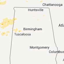
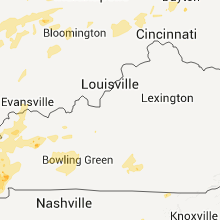
Hail Map for Tuesday, April 19, 2011

Number of Impacted Households on 4/19/2011
0
Impacted by 1" or Larger Hail
0
Impacted by 1.75" or Larger Hail
0
Impacted by 2.5" or Larger Hail
Square Miles of Populated Area Impacted on 4/19/2011
0
Impacted by 1" or Larger Hail
0
Impacted by 1.75" or Larger Hail
0
Impacted by 2.5" or Larger Hail


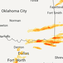

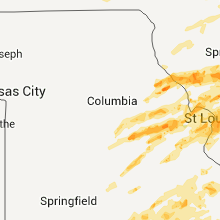
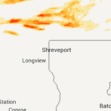


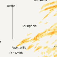

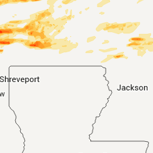


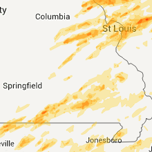


Cities Most Affected by Hail Storms of 4/19/2011
| Hail Size | Demographics of Zip Codes Affected | ||||||
|---|---|---|---|---|---|---|---|
| City | Count | Average | Largest | Pop Density | House Value | Income | Age |
| O Fallon, MO | 6 | 1.83 | 2.00 | 713 | $136k | $57.3k | 35.6 |
| Cleburne, TX | 4 | 2.25 | 2.75 | 156 | $0k | $0.0k | 36.8 |
| Little Rock, AR | 5 | 1.75 | 1.75 | 322 | $62k | $26.2k | 38.8 |
| Paris, TX | 4 | 2.19 | 2.75 | 123 | $65k | $34.6k | 39.1 |
| Ashdown, AR | 4 | 2.06 | 2.75 | 34 | $59k | $30.7k | 41.7 |
| Clarksville, TX | 2 | 2.50 | 2.50 | 17 | $33k | $25.5k | 46.2 |
| Wasola, MO | 2 | 2.38 | 2.75 | 10 | $58k | $19.9k | 46.9 |
| Curryville, MO | 2 | 2.25 | 2.75 | 12 | $78k | $28.5k | 37.2 |
| Clarksville, MO | 1 | 4.50 | 4.50 | 13 | $66k | $30.6k | 48.0 |
| Lake Saint Louis, MO | 2 | 2.25 | 2.75 | 1576 | $170k | $76.9k | 38.0 |
| Loose Creek, MO | 2 | 2.13 | 2.50 | 27 | $102k | $50.4k | 38.4 |
| Stringtown, OK | 1 | 4.25 | 4.25 | 1 | $41k | $25.8k | 45.4 |
| Moyers, OK | 2 | 1.88 | 2.00 | 2 | $39k | $26.5k | 52.0 |
| West Plains, MO | 2 | 1.88 | 2.00 | 54 | $73k | $27.3k | 39.0 |
| Jonesboro, AR | 2 | 1.75 | 1.75 | 323 | $92k | $37.7k | 32.8 |
| Waterloo, IL | 2 | 1.75 | 1.75 | 117 | $125k | $51.4k | 41.7 |
| White Hall, IL | 2 | 1.75 | 1.75 | 44 | $40k | $27.8k | 41.9 |
| Jerseyville, IL | 2 | 1.75 | 1.75 | 93 | $82k | $41.1k | 40.4 |
| Hooks, TX | 2 | 1.75 | 1.75 | 82 | $54k | $32.4k | 38.9 |
| Fort Worth, TX | 2 | 1.75 | 1.75 | 1552 | $30k | $20.0k | 32.9 |
| Powderly, TX | 2 | 1.75 | 1.75 | 40 | $76k | $44.6k | 45.2 |
| Horatio, AR | 2 | 1.75 | 1.75 | 19 | $52k | $32.1k | 35.8 |
| Springdale, AR | 1 | 3.00 | 3.00 | 893 | $86k | $34.2k | 28.8 |
| Hillsboro, TX | 1 | 3.00 | 3.00 | 65 | $58k | $28.8k | 35.3 |
| Roodhouse, IL | 1 | 2.75 | 2.75 | 27 | $40k | $31.3k | 39.9 |
| Berryville, AR | 1 | 2.75 | 2.75 | 50 | $73k | $27.3k | 38.0 |
| Willow Springs, MO | 1 | 2.75 | 2.75 | 24 | $52k | $22.5k | 40.8 |
| Protem, MO | 1 | 2.50 | 2.50 | 10 | $65k | $28.1k | 56.3 |
| Tuskahoma, OK | 1 | 2.50 | 2.50 | 7 | $44k | $24.5k | 49.0 |
| Covington, TX | 1 | 2.50 | 2.50 | 23 | $69k | $40.7k | 43.6 |
| Lead Hill, AR | 1 | 2.50 | 2.50 | 23 | $38k | $26.3k | 48.2 |
| Golden Eagle, IL | 1 | 2.50 | 2.50 | 27 | $84k | $36.4k | 47.2 |
| Plainview, AR | 1 | 2.50 | 2.50 | 3 | $44k | $26.1k | 46.2 |
| Ava, MO | 1 | 2.50 | 2.50 | 18 | $55k | $25.9k | 44.4 |
| Achille, OK | 1 | 2.00 | 2.00 | 0 | $41k | $20.7k | 37.1 |
| Harrison, AR | 1 | 2.00 | 2.00 | 81 | $77k | $30.5k | 40.7 |
| Princeville, IL | 1 | 2.00 | 2.00 | 31 | $89k | $47.6k | 39.6 |
| Savoy, TX | 1 | 2.00 | 2.00 | 24 | $52k | $37.9k | 44.4 |
| Saint Louis, MO | 1 | 2.00 | 2.00 | 2833 | $179k | $60.7k | 42.5 |
| Bedford, TX | 1 | 2.00 | 2.00 | 4784 | $126k | $59.6k | 41.3 |
| Rosebud, MO | 1 | 2.00 | 2.00 | 27 | $68k | $36.3k | 43.0 |
| Haworth, OK | 1 | 1.75 | 1.75 | 8 | $31k | $21.0k | 41.8 |
| Klondike, TX | 1 | 1.75 | 1.75 | 23 | $37k | $26.6k | 48.1 |
| Itasca, TX | 1 | 1.75 | 1.75 | 30 | $42k | $33.3k | 37.1 |
| Milford, TX | 1 | 1.75 | 1.75 | 11 | $45k | $31.1k | 37.8 |
| Dierks, AR | 1 | 1.75 | 1.75 | 9 | $43k | $29.6k | 41.2 |
| Traskwood, AR | 1 | 1.75 | 1.75 | 35 | $64k | $39.2k | 38.7 |
| Foreman, AR | 1 | 1.75 | 1.75 | 14 | $51k | $27.4k | 40.8 |
| Caseyville, IL | 1 | 1.75 | 1.75 | 554 | $68k | $36.4k | 40.2 |
| Greenville, IL | 1 | 1.75 | 1.75 | 58 | $77k | $40.3k | 37.9 |
| Arcadia, IN | 1 | 1.75 | 1.75 | 53 | $97k | $53.6k | 39.2 |
| Leslie, MO | 1 | 1.75 | 1.75 | 34 | $88k | $41.1k | 42.3 |
| Saint David, IL | 1 | 1.75 | 1.75 | 0 | $42k | $31.4k | 39.5 |
| Bland, MO | 1 | 1.75 | 1.75 | 14 | $48k | $32.0k | 45.9 |
| Robertsville, MO | 1 | 1.75 | 1.75 | 83 | $96k | $52.3k | 41.8 |
| Eagletown, OK | 1 | 1.75 | 1.75 | 5 | $37k | $21.5k | 42.3 |
| Crawfordsville, IN | 1 | 1.75 | 1.75 | 116 | $93k | $40.9k | 39.5 |
| Atoka, OK | 1 | 1.75 | 1.75 | 20 | $44k | $23.1k | 38.5 |
| Rosston, AR | 1 | 1.75 | 1.75 | 9 | $30k | $26.4k | 44.0 |
| Grafton, IL | 1 | 1.75 | 1.75 | 29 | $90k | $41.2k | 44.6 |
| Calvert City, KY | 1 | 1.75 | 1.75 | 125 | $76k | $37.4k | 44.1 |
| Grapevine, TX | 1 | 1.75 | 1.75 | 1309 | $157k | $71.9k | 37.5 |
| Amity, AR | 1 | 1.75 | 1.75 | 17 | $49k | $27.5k | 38.7 |
| Granite City, IL | 1 | 1.75 | 1.75 | 979 | $62k | $37.1k | 38.8 |
| Blue Eye, MO | 1 | 1.75 | 1.75 | 78 | $124k | $32.5k | 55.1 |
| Lewisville, TX | 1 | 1.75 | 1.75 | 1356 | $88k | $44.8k | 30.5 |
| Hindsville, AR | 1 | 1.75 | 1.75 | 26 | $57k | $34.6k | 41.5 |
| Bowling Green, MO | 1 | 1.75 | 1.75 | 38 | $71k | $33.2k | 37.6 |
| Fort Leonard Wood, MO | 1 | 1.75 | 1.75 | 110 | $65k | $33.9k | 21.2 |
| Stilesville, IN | 1 | 1.75 | 1.75 | 27 | $95k | $47.8k | 45.5 |
| Louisiana, MO | 1 | 1.75 | 1.75 | 57 | $57k | $31.9k | 43.0 |
| Denton, TX | 1 | 1.75 | 1.75 | 2045 | $142k | $54.4k | 26.7 |
| Joshua, TX | 1 | 1.75 | 1.75 | 332 | $91k | $44.8k | 35.1 |
| New Haven, MO | 1 | 1.75 | 1.75 | 53 | $87k | $42.8k | 40.7 |
| Senath, MO | 1 | 1.75 | 1.75 | 30 | $46k | $23.5k | 39.3 |
| Fayetteville, AR | 1 | 1.75 | 1.75 | 287 | $100k | $31.1k | 26.4 |
| Lockesburg, AR | 1 | 1.75 | 1.75 | 10 | $43k | $29.0k | 41.1 |
| Keller, TX | 1 | 1.75 | 1.75 | 2556 | $166k | $80.6k | 39.5 |
| Burleson, TX | 1 | 1.75 | 1.75 | 816 | $93k | $52.7k | 36.2 |
| Wentzville, MO | 1 | 1.75 | 1.75 | 555 | $138k | $51.8k | 32.9 |
| Linn, MO | 1 | 1.75 | 1.75 | 34 | $83k | $40.0k | 36.8 |
| Daisy, OK | 1 | 1.75 | 1.75 | 3 | $49k | $21.5k | 46.0 |
| The Colony, TX | 1 | 1.75 | 1.75 | 2084 | $96k | $62.7k | 32.8 |
| Godley, TX | 1 | 1.75 | 1.75 | 33 | $77k | $45.8k | 37.8 |
| Honey Grove, TX | 1 | 1.75 | 1.75 | 19 | $53k | $30.8k | 42.6 |
| Grandview, TX | 1 | 1.75 | 1.75 | 46 | $76k | $48.4k | 40.8 |
| Gurdon, AR | 1 | 1.75 | 1.75 | 19 | $42k | $29.6k | 40.7 |
| Krum, TX | 1 | 1.75 | 1.75 | 112 | $97k | $53.6k | 34.5 |
| Eureka Springs, AR | 1 | 1.75 | 1.75 | 47 | $101k | $27.3k | 52.7 |
| Sumner, TX | 1 | 1.75 | 1.75 | 25 | $61k | $37.6k | 39.4 |
| Hillview, IL | 1 | 1.75 | 1.75 | 7 | $28k | $31.1k | 44.1 |
| Alligator, MS | 1 | 1.75 | 1.75 | 9 | $49k | $28.5k | 42.3 |
| Muse, OK | 1 | 1.75 | 1.75 | 4 | $36k | $16.0k | 45.3 |
| Arthur City, TX | 1 | 1.75 | 1.75 | 13 | $44k | $25.5k | 46.1 |
| De Kalb, TX | 1 | 1.75 | 1.75 | 23 | $51k | $28.3k | 44.1 |
Hail and Wind Damage Spotted on 4/19/2011
Filter by Report Type:Hail ReportsWind Reports
States Impacted
Illinois, Missouri, West Virginia, Indiana, Texas, Ohio, Oklahoma, Arkansas, Colorado, Michigan, Kentucky, Mississippi, Tennessee, Pennsylvania, Alabama, GeorgiaIllinois
| Local Time | Report Details |
|---|---|
| 12:03 PM UTC | Golf Ball sized hail reported near Waterloo, IL, 17.2 miles S of Saint Louis, MO |
| 12:04 PM UTC | Golf Ball sized hail reported near Waterloo, IL, 20.6 miles S of Saint Louis, MO |
| 7:05 AM CDT | Ping Pong Ball sized hail reported near Granite City, IL, 6.8 miles NNE of Saint Louis, MO |
| 7:09 AM CDT | Ping Pong Ball sized hail reported near Granite City, IL, 6.8 miles NNE of Saint Louis, MO |
| 12:14 PM UTC | Quarter sized hail reported near Edwardsville, IL, 17.2 miles NE of Saint Louis, MO, on campus of siu-edwardsville. |
| 1:16 PM UTC | Quarter sized hail reported near Donnellson, IL, 46.6 miles ENE of Saint Louis, MO |
| 1:20 PM UTC | Quarter sized hail reported near Patoka, IL, 58.4 miles E of Saint Louis, MO |
| 1:26 PM UTC | Quarter sized hail reported near Fillmore, IL, 54.5 miles WSW of Mattoon, IL, 2223 burg trail fillmore il along highway 185 near van burensburg. hail covering the ground. |
| 1:42 PM UTC | Quarter sized hail reported near St Peter, IL, 49.3 miles SSW of Mattoon, IL |
| 1:53 PM UTC | Quarter sized hail reported near Mason, IL, 39.1 miles SSW of Mattoon, IL |
| 2:28 PM UTC | Half Dollar sized hail reported near Neoga, IL, 11.8 miles SSW of Mattoon, IL |
| 2:31 PM UTC | Quarter sized hail reported near Lerna, IL, 6.2 miles SE of Mattoon, IL |
| 10:00 PM UTC | Tennis Ball sized hail reported near Golden Eagle, IL, 27.4 miles NW of Saint Louis, MO, hail ranging in size from half dollars to tennis balls |
| 10:05 PM UTC | Half Dollar sized hail reported near Nebo, IL, 64.4 miles NNW of Saint Louis, MO |
| 10:13 PM UTC | Half Dollar sized hail reported near Jerseyville, IL, 35.2 miles NNW of Saint Louis, MO |
| 10:16 PM UTC | Golf Ball sized hail reported near Jerseyville, IL, 34.7 miles NNW of Saint Louis, MO |
| 10:23 PM UTC | Golf Ball sized hail reported near Hillview, IL, 58 miles NNW of Saint Louis, MO |
| 10:29 PM UTC | Golf Ball sized hail reported near White Hall, IL, 57.1 miles N of Saint Louis, MO |
| 10:33 PM UTC | Golf Ball sized hail reported near White Hall, IL, 58 miles NNW of Saint Louis, MO, about two minutes from the time of the report |
| 10:38 PM UTC | Quarter sized hail reported near Roodhouse, IL, 59.5 miles N of Saint Louis, MO |
| 10:38 PM UTC | Storm damage reported in greene county IL, 59.5 miles N of Saint Louis, MO |
| 10:45 PM UTC | Half Dollar sized hail reported near Carlinville, IL, 48.2 miles NNE of Saint Louis, MO, hail up to half dollars in carlinville |
| 10:54 PM UTC | Baseball sized hail reported near Roodhouse, IL, 59.5 miles N of Saint Louis, MO |
| 10:55 PM UTC | Quarter sized hail reported near New Berlin, IL, 70.5 miles SSW of Peoria, IL |
| 10:57 PM UTC | Half Dollar sized hail reported near Sherman, IL, 55.4 miles S of Peoria, IL |
| 10:57 PM UTC | Ping Pong Ball sized hail reported near Grafton, IL, 26.7 miles NNW of Saint Louis, MO |
| 11:00 PM UTC | Quarter sized hail reported near Sherman, IL, 54.7 miles S of Peoria, IL |
| 11:02 PM UTC | Quarter sized hail reported near Jerseyville, IL, 34 miles NNW of Saint Louis, MO |
| 11:02 PM UTC | Golf Ball sized hail reported near Otterville, IL, 31.1 miles NNW of Saint Louis, MO |
| 11:02 PM UTC | Farm buildings damaged in sangamon county IL, 70.6 miles NNE of Saint Louis, MO |
| 11:04 PM UTC | Ping Pong Ball sized hail reported near Jerseyville, IL, 34.7 miles NNW of Saint Louis, MO |
| 11:05 PM UTC | Roof damage in chatham in sangamon county IL, 70.8 miles S of Peoria, IL |
| 11:06 PM UTC | Delayed report. 8 power poles snapped in half and power lines down on south 2nd street at southwind park on the south side of springfield. time estimate in sangamon county IL, 65.7 miles S of Peoria, IL |
| 11:06 PM UTC | Golf Ball sized hail reported near Jerseyville, IL, 34.7 miles NNW of Saint Louis, MO |
| 11:10 PM UTC | Quarter sized hail reported near Williamsville, IL, 51.2 miles S of Peoria, IL, cocorahs |
| 11:11 PM UTC | Wind blew roof off a house in sangamon county IL, 70.8 miles S of Peoria, IL |
| 11:13 PM UTC | Hen Egg sized hail reported near Princeville, IL, 18.7 miles NNW of Peoria, IL, delayed report. |
| 11:16 PM UTC | Storm damage reported in macoupin county IL, 48.2 miles NNE of Saint Louis, MO |
| 11:20 PM UTC | Quarter sized hail reported near Cuba, IL, 34.6 miles WSW of Peoria, IL |
| 11:21 PM UTC | Wide spread power outage in city of taylorville in christian county IL, 47.3 miles W of Mattoon, IL |
| 11:25 PM UTC | Storm damage reported in christian county IL, 58.1 miles W of Mattoon, IL |
| 11:25 PM UTC | Storm damage reported in christian county IL, 55.8 miles W of Mattoon, IL |
| 11:30 PM UTC | Siding ripped off some buildings on cherokee street in christian county IL, 47.3 miles W of Mattoon, IL |
| 11:30 PM UTC | Trees blown down on spencer street in christian county IL, 47.3 miles W of Mattoon, IL |
| 11:30 PM UTC | Trees and power poles snapped down in sangamon county IL, 63.7 miles W of Mattoon, IL |
| 11:30 PM UTC | Quarter sized hail reported near Peru, IL, 49.8 miles NNE of Peoria, IL, mostly pea to penny sized hail with a couple as large as one inch |
| 11:34 PM UTC | Quarter sized hail reported near Brighton, IL, 28.6 miles N of Saint Louis, MO |
| 11:34 PM UTC | Quarter sized hail reported near Brighton, IL, 28.5 miles N of Saint Louis, MO |
| 11:37 PM UTC | Storm damage reported in macoupin county IL, 34.9 miles NNE of Saint Louis, MO |
| 11:40 PM UTC | Rail cars blow off tracks in christian county IL, 47.3 miles W of Mattoon, IL |
| 11:45 PM UTC | Storm damage reported in logan county IL, 52.4 miles NW of Mattoon, IL |
| 11:49 PM UTC | Quarter sized hail reported near Dorchester, IL, 36 miles NNE of Saint Louis, MO |
| 11:49 PM UTC | Power lines down in montgomery county IL, 61.4 miles NE of Saint Louis, MO |
| 11:50 PM UTC | Storm damage reported in macon county IL, 33.9 miles NW of Mattoon, IL |
| 11:51 PM UTC | Small tree limbs down...trampoline blown over in montgomery county IL, 47.9 miles NE of Saint Louis, MO |
| 11:53 PM UTC | Power lines down in madison county IL, 26.5 miles NE of Saint Louis, MO |
| 11:54 PM UTC | Damage to grain bin...power lines down and house damaged from previous storm in farmersville in montgomery county IL, 63.4 miles NNE of Saint Louis, MO |
| 11:54 PM UTC | Golf Ball sized hail reported near St David, IL, 28 miles WSW of Peoria, IL |
| 12:00 AM UTC | 1 foot diameter tree limb blown down in macoupin county IL, 64.5 miles NNE of Saint Louis, MO |
| 12:09 AM UTC | 17 inch diameter tree blown down in macoupin county IL, 38.4 miles NNE of Saint Louis, MO |
| 12:11 AM UTC | Storm damage reported in piatt county IL, 39.2 miles NNW of Mattoon, IL |
| 12:14 AM UTC | Storm damage reported in piatt county IL, 39.2 miles NNW of Mattoon, IL |
| 12:15 AM UTC | Quarter sized hail reported near Roxana, IL, 16.7 miles NNE of Saint Louis, MO |
| 12:16 AM UTC | Quarter sized hail reported near Wood River, IL, 17.3 miles NNE of Saint Louis, MO |
| 12:25 AM UTC | Power poles snapped in macoupin county IL, 34.9 miles NNE of Saint Louis, MO |
| 12:26 AM UTC | Ping Pong Ball sized hail reported near New Douglas, IL, 37.1 miles NE of Saint Louis, MO |
| 12:27 AM UTC | Quarter sized hail reported near Worden, IL, 31.4 miles NE of Saint Louis, MO |
| 12:30 AM UTC | Quarter sized hail reported near Champaign, IL, 43.8 miles N of Mattoon, IL |
| 12:30 AM UTC | 60-65 mph estimated near champaign and piatt county line in champaign county IL, 49 miles N of Mattoon, IL |
| 12:35 AM UTC | Quarter sized hail reported near Pesotum, IL, 27.7 miles N of Mattoon, IL |
| 12:45 AM UTC | Storm damage reported in coles county IL, 15.6 miles ESE of Mattoon, IL |
| 12:45 AM UTC | Storm damage reported in champaign county IL, 46.9 miles NNE of Mattoon, IL |
| 12:45 AM UTC | Shingles blown off home and 8 inch tree blown down in coles county IL, 9.9 miles E of Mattoon, IL |
| 7:50 PM CDT | Golf Ball sized hail reported near Granite City, IL, 6.8 miles NNE of Saint Louis, MO |
| 12:58 AM UTC | Quarter sized hail reported near , , 11.4 miles ENE of Saint Louis, MO |
| 12:59 AM UTC | Golf Ball sized hail reported near Caseyville, IL, 9.2 miles E of Saint Louis, MO |
| 1:00 AM UTC | Quarter sized hail reported near Sidell, IL, 46.1 miles NE of Mattoon, IL |
| 1:00 AM UTC | Quarter sized hail reported near Edwardsville, IL, 18.4 miles NE of Saint Louis, MO |
| 1:00 AM UTC | Golf Ball sized hail reported near , , 11.4 miles ENE of Saint Louis, MO |
| 1:03 AM UTC | Golf Ball sized hail reported near , , 11.4 miles ENE of Saint Louis, MO |
| 1:04 AM UTC | Large area of tree damage observed at fort kaskaskia state historic site. large trees uprooted...including 30 inch diameter pecan tree and branches down up to 12 inches in randolph county IL, 47.3 miles NNW of Cape Girardeau, MO |
| 1:05 AM UTC | Trees down in vermilion county IL, 71.9 miles NNE of Mattoon, IL |
| 1:07 AM UTC | Ping Pong Ball sized hail reported near , , 11.4 miles ENE of Saint Louis, MO |
| 1:10 AM UTC | Small tree branches down in st. clair county IL, 12.7 miles ESE of Saint Louis, MO |
| 1:11 AM UTC | Quarter sized hail reported near Troy, IL, 18.2 miles ENE of Saint Louis, MO |
| 1:12 AM UTC | Quarter sized hail reported near Marine, IL, 23.2 miles ENE of Saint Louis, MO, at i-270 and rt 4 |
| 1:13 AM UTC | Quarter sized hail reported near Edwardsville, IL, 18 miles NE of Saint Louis, MO |
| 1:15 AM UTC | Power poles blown down reported by spoters at the intersection of illinois route 1 and illinois route 9 in vermilion county IL, 77.8 miles NNE of Mattoon, IL |
| 1:17 AM UTC | Storm damage reported in st. clair county IL, 19.9 miles ESE of Saint Louis, MO |
| 1:20 AM UTC | Storm damage reported in st. clair county IL, 19.7 miles ESE of Saint Louis, MO |
| 1:21 AM UTC | Trees and power lines down in marissa in st. clair county IL, 35.2 miles SE of Saint Louis, MO |
| 1:22 AM UTC | Golf Ball sized hail reported near Greenville, IL, 46.8 miles ENE of Saint Louis, MO, in pocahontas and greenville |
| 1:30 AM UTC | Quarter sized hail reported near Greenville, IL, 46.8 miles ENE of Saint Louis, MO, at the greenville exit on interstate 70 |
| 1:34 AM UTC | Storm damage reported in perry county IL, 48.3 miles N of Cape Girardeau, MO |
| 1:35 AM UTC | Storm damage reported in jackson county IL, 33.9 miles NNE of Cape Girardeau, MO |
| 1:39 AM UTC | Storm damage reported in madison county IL, 28.7 miles ENE of Saint Louis, MO |
| 1:40 AM UTC | Late report. time estimated. police station had 1/3 of roof blown off which landed onto 3 nearby homes. em determined event was straight line wind in jackson county IL, 33.9 miles NNE of Cape Girardeau, MO |
| 1:40 AM UTC | Late report. time estimated. widespread tree damage across south half of county. more concentrated areas of damage include the southwest side of du quoin as well as con in perry county IL, 50.9 miles NNE of Cape Girardeau, MO |
| 1:40 AM UTC | 2 inch diameter tree branches blown down in randolph county IL, 42 miles SE of Saint Louis, MO |
| 1:40 AM UTC | Late report. carports blown over along south pine st. winds estimated 60 to 70 mp in franklin county IL, 49.3 miles NNE of Cape Girardeau, MO |
| 1:41 AM UTC | Power out in the cit in williamson county IL, 43.4 miles NE of Cape Girardeau, MO |
| 1:41 AM UTC | Winds estimated 60 to 70 mph gusts with entire community without powe in williamson county IL, 43.4 miles NE of Cape Girardeau, MO |
| 1:44 AM UTC | Storm chaser observing multiple power flashes in washington county IL, 48.4 miles ESE of Saint Louis, MO |
| 1:48 AM UTC | Trees snapping with power outages reporte in williamson county IL, 44.4 miles NE of Cape Girardeau, MO |
| 1:49 AM UTC | Ping Pong Ball sized hail reported near Oconee, IL, 38.9 miles WSW of Mattoon, IL, location is 1.5 miles south of herrick |
| 1:50 AM UTC | Late repor in johnson county IL, 34.6 miles ENE of Cape Girardeau, MO |
| 1:54 AM UTC | Storm damage reported in franklin county IL, 59.6 miles NE of Cape Girardeau, MO |
| 1:54 AM UTC | Wind gust 80 to 95 mph measure in johnson county IL, 33.7 miles ENE of Cape Girardeau, MO |
| 1:54 AM UTC | Nickel size hail and small tree limbs blown down in fayette county IL, 40.5 miles SW of Mattoon, IL |
| 1:56 AM UTC | Large tree limbs blown down as well as whole trees blown onto roads from this evenings storms in st. clair county IL, 12.9 miles ESE of Saint Louis, MO |
| 1:57 AM UTC | Late report. lost roof off of one hom in franklin county IL, 51.8 miles NNE of Cape Girardeau, MO |
| 1:59 AM UTC | Semi blown over on interstate 57 at the centralia exit in marion county IL, 58.4 miles E of Saint Louis, MO |
| 2:00 AM UTC | Time estimated. widespread trees and power lines dow in franklin county IL, 60.7 miles NNE of Cape Girardeau, MO |
| 2:02 AM UTC | Sustained 44 knots in marion county IL, 61.3 miles E of Saint Louis, MO |
| 2:07 AM UTC | Storm damage reported in saline county IL, 56.3 miles WSW of Evansville, IN |
| 2:10 AM UTC | Quarter sized hail reported near Martinsville, IL, 27.1 miles ESE of Mattoon, IL, spotter reported 5 minutes of quarter sized hail. |
| 2:12 AM UTC | Late report. numerous trees down. power outages. large farm building near exit 89 along interstate 64 destroyed. appeared to be straight line wind in jefferson county IL, 67 miles WNW of Evansville, IN |
| 2:13 AM UTC | Quarter sized hail reported near Neoga, IL, 11.8 miles SSW of Mattoon, IL |
| 2:15 AM UTC | Trees down outside of community along hastings ranch roa in alexander county IL, 8.2 miles SE of Cape Girardeau, MO |
| 2:19 AM UTC | Numerous trees and power lines down mainly in the eastern portion of centralia in marion county IL, 58.4 miles E of Saint Louis, MO |
| 2:19 AM UTC | Telephone poles snapped with wind gusts estimated 60 mph. nickel size hail just south of tow in wayne county IL, 63.7 miles WNW of Evansville, IN |
| 2:20 AM UTC | Scattered trees and power lines down in marion county IL, 66.4 miles SSW of Mattoon, IL |
| 2:23 AM UTC | Trees down in clay county IL, 56.3 miles S of Mattoon, IL |
| 2:23 AM UTC | Several trees down. time estimated from rada in clay county IL, 59.8 miles SSW of Mattoon, IL |
| 2:23 AM UTC | Half Dollar sized hail reported near Marshall, IL, 36.8 miles E of Mattoon, IL |
| 2:25 AM UTC | Mobile home that was not tied down has blown away. a few farm sheds have been damaged near the wayne jefferson county lin in wayne county IL, 59.9 miles WNW of Evansville, IN |
| 2:27 AM UTC | Large tree limbs bown down from this evenings storms in washington county IL, 51.8 miles ESE of Saint Louis, MO |
| 2:29 AM UTC | Just east of the city limits in wayne county IL, 60.2 miles NW of Evansville, IN |
| 2:30 AM UTC | Late report. widespread trees down as well as power poles snapped. much of the city is without power. one home had large uprooted tree fell across a home. in north city in white county IL, 34 miles WNW of Evansville, IN |
| 2:30 AM UTC | Late report. barns blown down. trees dow in white county IL, 43.2 miles WNW of Evansville, IN |
| 2:40 AM UTC | Numerous large trees blown down in town. three quarters of the town is without powe in marion county IL, 58.4 miles E of Saint Louis, MO |
| 2:40 AM UTC | Sheds...barns and mobile homes damaged in marion county IL, 58.4 miles E of Saint Louis, MO |
| 2:40 AM UTC | Late report. considerable damage to house and barn. trees damage in gallatin county IL, 43.1 miles WSW of Evansville, IN |
| 2:45 AM UTC | Trees and power lines dow in white county IL, 26.9 miles W of Evansville, IN |
| 2:47 AM UTC | Several trees down west of the city limits and dime size hail in johnson county IL, 36.8 miles ENE of Cape Girardeau, MO |
| 2:49 AM UTC | Wind gusts estimated 80 to 90 mp in alexander county IL, 14.1 miles SE of Cape Girardeau, MO |
| 2:51 AM UTC | Wind gust measured. numerous trees and power lines down. power outages reporte in alexander county IL, 14.1 miles SE of Cape Girardeau, MO |
| 3:09 AM UTC | Large trees in lawrence county IL, 52.4 miles N of Evansville, IN |
| 3:10 AM UTC | Storm damage reported in lawrence county IL, 59.6 miles N of Evansville, IN |
| 3:10 AM UTC | 6 trees down...one on a house. also several large limbs dow in crawford county IL, 47.1 miles SE of Mattoon, IL |
| 3:13 AM UTC | Large tree limbs down which broke windows of a house. also large storage shed destroye in lawrence county IL, 57.5 miles N of Evansville, IN |
| 3:45 AM UTC | A few trees down on market street in the city limits in massac county IL, 47.2 miles ESE of Cape Girardeau, MO |
Missouri
| Local Time | Report Details |
|---|---|
| 12:06 PM UTC | Roofing damage to a church reported by local tv stations. time estimated from rada in st. louis county MO, 11.2 miles N of Saint Louis, MO |
| 8:37 PM UTC | Quarter sized hail reported near Vandalia, MO, 51.6 miles ENE of Columbia, MO, hail was mostly one half inch...with some one inch in diameter mixed in |
| 8:51 PM UTC | Half Dollar sized hail reported near Curryville, MO, 60 miles ENE of Columbia, MO |
| 8:52 PM UTC | Baseball sized hail reported near Curryville, MO, 60 miles ENE of Columbia, MO, hail the size of golfballs and baseballs |
| 8:54 PM UTC | Quarter sized hail reported near Wellsville, MO, 42.9 miles ENE of Columbia, MO |
| 8:59 PM UTC | Golf Ball sized hail reported near Curryville, MO, 60 miles ENE of Columbia, MO, spotter was at the firehouse in curryville |
| 9:01 PM UTC | Quarter sized hail reported near Jefferson City, MO, 27.5 miles SSE of Columbia, MO |
| 9:02 PM UTC | Quarter sized hail reported near Jefferson City, MO, 27.5 miles SSE of Columbia, MO, multiple reports of quarter size hail in jefferson city |
| 9:12 PM UTC | Quarter sized hail reported near Fulton, MO, 21.9 miles ESE of Columbia, MO |
| 9:19 PM UTC | Golf Ball sized hail reported near Bowling Green, MO, 69.5 miles ENE of Columbia, MO, spotter located on highway 54 |
| 9:20 PM UTC | Golf Ball sized hail reported near Louisiana, MO, 72.7 miles NW of Saint Louis, MO |
| 9:27 PM UTC | Quarter sized hail reported near Mokane, MO, 31.7 miles SE of Columbia, MO, hail ranging from pea to quarter size |
| 9:40 PM UTC | Ping Pong Ball sized hail reported near Ofallon, MO, 29.6 miles WNW of Saint Louis, MO |
| 4:40 PM CDT | Softball sized hail reported near Clarksville, MO, 63.9 miles NW of Saint Louis, MO, report came in via twitter |
| 9:44 PM UTC | Golf Ball sized hail reported near Ofallon, MO, 29.5 miles WNW of Saint Louis, MO |
| 9:44 PM UTC | Golf Ball sized hail reported near Loose Creek, MO, 38.9 miles SSE of Columbia, MO |
| 9:45 PM UTC | Golf Ball sized hail reported near Ofallon, MO, 29.5 miles WNW of Saint Louis, MO, hail ranged in size from quarters to golfballs |
| 9:46 PM UTC | Golf Ball sized hail reported near Ofallon, MO, 29.5 miles WNW of Saint Louis, MO, bryan road and 70 |
| 9:47 PM UTC | Quarter sized hail reported near Linn, MO, 42.1 miles SE of Columbia, MO |
| 9:47 PM UTC | Tennis Ball sized hail reported near Loose Creek, MO, 38.9 miles SSE of Columbia, MO |
| 9:48 PM UTC | Ping Pong Ball sized hail reported near Ofallon, MO, 29.5 miles WNW of Saint Louis, MO |
| 9:49 PM UTC | Quarter sized hail reported near St Peters, MO, 24.5 miles WNW of Saint Louis, MO |
| 9:49 PM UTC | Ping Pong Ball sized hail reported near Ofallon, MO, 29.5 miles WNW of Saint Louis, MO |
| 9:50 PM UTC | Hen Egg sized hail reported near Ofallon, MO, 29.5 miles WNW of Saint Louis, MO, hail measured at 2 inches. hail was larger than 2 inches but had melted. |
| 9:52 PM UTC | Hen Egg sized hail reported near Ofallon, MO, 30.3 miles WNW of Saint Louis, MO, hail slightly larger than 2 inches. spotter is north of ofallon. |
| 9:54 PM UTC | Golf Ball sized hail reported near Linn, MO, 42.1 miles SE of Columbia, MO, hail ranging in size from dimes to golfballs in linn mo |
| 10:06 PM UTC | Ping Pong Ball sized hail reported near Morrison, MO, 46.8 miles ESE of Columbia, MO |
| 10:11 PM UTC | Golf Ball sized hail reported near Blue Eye, MO, 49.3 miles S of Springfield, MO |
| 10:15 PM UTC | Golf Ball sized hail reported near Fort Leonard Wood, MO, 34.6 miles W of Salem, MO, military police reported quarter to golf ball sized hail on the base. |
| 5:42 PM CDT | Golf Ball sized hail reported near New Melle, MO, 37.2 miles W of Saint Louis, MO |
| 10:43 PM UTC | Quarter sized hail reported near Moscow Mills, MO, 44.8 miles WNW of Saint Louis, MO |
| 10:43 PM UTC | Quarter sized hail reported near New Haven, MO, 57.9 miles W of Saint Louis, MO |
| 10:44 PM UTC | Baseball sized hail reported near Lake St Louis, MO, 33.3 miles WNW of Saint Louis, MO, golfballs to baseballs in lake st louis |
| 10:46 PM UTC | Ping Pong Ball sized hail reported near Lake St Louis, MO, 33.3 miles WNW of Saint Louis, MO, ping pong ball sized hail 2 miles south of highway 40 and highway n |
| 10:47 PM UTC | Ping Pong Ball sized hail reported near Dardenne Prairie, MO, 29.9 miles WNW of Saint Louis, MO, near highway n |
| 10:49 PM UTC | Quarter sized hail reported near Theodosia, MO, 55 miles SE of Springfield, MO |
| 10:49 PM UTC | Golf Ball sized hail reported near Lake St Louis, MO, 33.3 miles WNW of Saint Louis, MO, golf balls at highway n and 40 |
| 10:52 PM UTC | Quarter sized hail reported near Vichy, MO, 34.9 miles NNW of Salem, MO, wind gust of 49 mph at vichy asos |
| 10:53 PM UTC | Golf Ball sized hail reported near , , 38.9 miles NW of Saint Louis, MO |
| 10:53 PM UTC | Golf Ball sized hail reported near Ofallon, MO, 29.5 miles WNW of Saint Louis, MO, mexico and tr hughes |
| 10:54 PM UTC | Quarter sized hail reported near Ofallon, MO, 29.5 miles WNW of Saint Louis, MO, quarter size hail covering the ground at tr hughes and 70 |
| 10:55 PM UTC | Ping Pong Ball sized hail reported near Ofallon, MO, 29.5 miles WNW of Saint Louis, MO |
| 11:01 PM UTC | Hen Egg sized hail reported near Wasola, MO, 48.8 miles SE of Springfield, MO |
| 6:03 PM CDT | Quarter sized hail reported near Marthasville, MO, 40.7 miles W of Saint Louis, MO |
| 11:03 PM UTC | Golf Ball sized hail reported near Bland, MO, 39.2 miles N of Salem, MO |
| 11:04 PM UTC | Quarter sized hail reported near Ofallon, MO, 29.5 miles WNW of Saint Louis, MO |
| 11:05 PM UTC | Baseball sized hail reported near Willow Springs, MO, 50.6 miles SSW of Salem, MO |
| 11:05 PM UTC | Tennis Ball sized hail reported near Ava, MO, 50.3 miles ESE of Springfield, MO |
| 11:11 PM UTC | Baseball sized hail reported near Wasola, MO, 48.8 miles SE of Springfield, MO |
| 11:12 PM UTC | Quarter sized hail reported near Marthasville, MO, 42.8 miles W of Saint Louis, MO |
| 11:13 PM UTC | Hen Egg sized hail reported near Rosebud, MO, 52.5 miles N of Salem, MO |
| 11:19 PM UTC | Quarter sized hail reported near Gerald, MO, 55.9 miles NNE of Salem, MO |
| 11:20 PM UTC | Quarter sized hail reported near Gainesville, MO, 63.6 miles SE of Springfield, MO |
| 11:21 PM UTC | Golf Ball sized hail reported near New Haven, MO, 54.2 miles W of Saint Louis, MO, hail observed near highways 185 and yy |
| 11:23 PM UTC | Golf Ball sized hail reported near Leslie, MO, 56.5 miles WSW of Saint Louis, MO |
| 11:28 PM UTC | Quarter sized hail reported near Washington, MO, 46.6 miles W of Saint Louis, MO |
| 11:29 PM UTC | Storm damage reported in st. charles county MO, 20.6 miles WNW of Saint Louis, MO |
| 11:30 PM UTC | Quarter sized hail reported near St Charles, MO, 20.6 miles WNW of Saint Louis, MO |
| 11:35 PM UTC | Tennis Ball sized hail reported near Protem, MO, 54 miles SSE of Springfield, MO, postal carrier reported golf ball to tennis ball sized hail about 2 to 3 miles southeast of protem. |
| 11:40 PM UTC | Golf Ball sized hail reported near , , 47.2 miles SSW of Salem, MO |
| 11:48 PM UTC | Hen Egg sized hail reported near West Plains, MO, 54 miles SSW of Salem, MO, relayed by media. |
| 11:49 PM UTC | Between 649 pm and 7 pm...trees down blocking highway 19 between eminence and winona. trees also down at highway f...and trees and power lines down on highway e between in shannon county MO, 34.9 miles SSE of Salem, MO |
| 11:49 PM UTC | Power out in and around eminenc in shannon county MO, 34.9 miles SSE of Salem, MO |
| 11:52 PM UTC | Quarter sized hail reported near St Charles, MO, 20.6 miles WNW of Saint Louis, MO, 5th streed and arena parkway |
| 11:54 PM UTC | Quarter sized hail reported near Hazelwood, MO, 13.6 miles NW of Saint Louis, MO |
| 11:55 PM UTC | Quarter sized hail reported near Eminence, MO, 38.4 miles SSE of Salem, MO |
| 11:56 PM UTC | Quarter sized hail reported near Florissant, MO, 13.6 miles NNW of Saint Louis, MO, howdershell and dunn road |
| 12:01 AM UTC | Hen Egg sized hail reported near , , 44.8 miles SSW of Salem, MO, relayed by media. |
| 12:13 AM UTC | Roof ripped off a portion of the christ light of the nations school in st. louis county MO, 11.2 miles N of Saint Louis, MO |
| 12:22 AM UTC | Quarter sized hail reported near Manchester, MO, 17 miles W of Saint Louis, MO |
| 12:23 AM UTC | Quarter sized hail reported near Ballwin, MO, 19.1 miles W of Saint Louis, MO, weidman and manchester roads |
| 12:23 AM UTC | Quarter sized hail reported near Kirkwood, MO, 12.4 miles WSW of Saint Louis, MO |
| 12:23 AM UTC | Quarter sized hail reported near Sullivan, MO, 41.2 miles NE of Salem, MO |
| 12:23 AM UTC | Golf Ball sized hail reported near Robertsville, MO, 38 miles WSW of Saint Louis, MO |
| 12:24 AM UTC | Quarter sized hail reported near Van Buren, MO, 52 miles SE of Salem, MO |
| 12:25 AM UTC | Quarter sized hail reported near Des Peres, MO, 13.7 miles W of Saint Louis, MO |
| 12:25 AM UTC | Quarter sized hail reported near Piedmont, MO, 56.5 miles SE of Salem, MO, quater size hail reported near clearwater lake. |
| 12:25 AM UTC | Wind gusts 60 to 65 mph. widespread tstm wind damge reported throughout the community. trees snapped. power poles and power lines down. numerous power outage in wayne county MO, 56.9 miles SE of Salem, MO |
| 12:25 AM UTC | Piedmont awos repor in wayne county MO, 56.9 miles SE of Salem, MO |
| 12:30 AM UTC | Quarter sized hail reported near Olivette, MO, 10.2 miles WNW of Saint Louis, MO |
| 12:33 AM UTC | Quarter sized hail reported near Warson Woods, MO, 10.4 miles W of Saint Louis, MO |
| 12:35 AM UTC | Quarter sized hail reported near Brentwood, MO, 8.2 miles W of Saint Louis, MO |
| 12:35 AM UTC | Quarter sized hail reported near University City, MO, 7.6 miles WNW of Saint Louis, MO |
| 12:40 AM UTC | Hen Egg sized hail reported near Warson Woods, MO, 10.4 miles W of Saint Louis, MO |
| 12:43 AM UTC | Quarter sized hail reported near Sunset Hills, MO, 13.4 miles WSW of Saint Louis, MO |
| 12:47 AM UTC | Trees down on west side of communit in wayne county MO, 51.3 miles WSW of Cape Girardeau, MO |
| 12:50 AM UTC | Mobile home siding torn off in st. louis county MO, 14.2 miles WSW of Saint Louis, MO |
| 12:50 AM UTC | Quarter sized hail reported near Sunset Hills, MO, 13.4 miles WSW of Saint Louis, MO |
| 12:50 AM UTC | Half Dollar sized hail reported near Sunset Hills, MO, 14.2 miles WSW of Saint Louis, MO, mobile home siding torn off |
| 12:53 AM UTC | Storm damage reported in jefferson county MO, 30.4 miles SSW of Saint Louis, MO |
| 12:54 AM UTC | Quarter sized hail reported near St Louis, MO, 8.9 miles SW of Saint Louis, MO, i-270 and tesson ferry |
| 12:55 AM UTC | Quarter sized hail reported near St Louis, MO, 2.3 miles WNW of Saint Louis, MO, at 7th and washington. time estimated |
| 12:55 AM UTC | Winds estimated 70 to 75 mph. widespread damage reported by em west and north of marble hill. majority of damage apprears to be straight line winds. some homes have roo in bollinger county MO, 24 miles W of Cape Girardeau, MO |
| 12:56 AM UTC | Trees down at hwy 67 and 221 in st. francois county MO, 58.7 miles NW of Cape Girardeau, MO |
| 12:57 AM UTC | Storm damage reported in madison county MO, 45.2 miles WNW of Cape Girardeau, MO |
| 12:58 AM UTC | Ping Pong Ball sized hail reported near West Plains, MO, 64.9 miles SSW of Salem, MO, relayed by media. |
| 12:59 AM UTC | Power poles and trees down in ste. genevieve in ste. genevieve county MO, 46.1 miles S of Saint Louis, MO |
| 1:00 AM UTC | Quarter sized hail reported near Brentwood, MO, 8.2 miles W of Saint Louis, MO |
| 1:01 AM UTC | Quarter sized hail reported near West Plains, MO, 64.9 miles SSW of Salem, MO, one inch hail observed downtown west plains. |
| 1:10 AM UTC | Trees down on many area roads around ellington. from the storm earlier in the evenin in reynolds county MO, 41.4 miles SE of Salem, MO |
| 1:15 AM UTC | Quarter sized hail reported near Winona, MO, 46.8 miles SSE of Salem, MO |
| 1:15 AM UTC | Report of roof damage to a hardware store in ste. genevieve county MO, 46.1 miles S of Saint Louis, MO |
| 1:19 AM UTC | Barn blown into state highway b in daisy and trees are down across roadway making it impassabl in cape girardeau county MO, 20.2 miles NW of Cape Girardeau, MO |
| 1:19 AM UTC | Straight line wind damage. numerous trees down. power outages. barn blown over along intersection of highway b and aa. widespread tree damage and missouri dot is respon in cape girardeau county MO, 20.2 miles NW of Cape Girardeau, MO |
| 1:25 AM UTC | Late report. major roof damage to high school on city limits. hvac unit blown off roof. 30 by 120 foot section of roof peeled off down to rafter in cape girardeau county MO, 0.6 miles NNW of Cape Girardeau, MO |
| 1:29 AM UTC | Storm damage reported in cape girardeau county MO, 0.6 miles NNW of Cape Girardeau, MO |
| 1:31 AM UTC | Golf Ball sized hail reported near West Plains, MO, 54 miles SSW of Salem, MO, golf ball sized hail near intersection of hwy 17 and ee. |
| 2:20 AM UTC | Also marble size hail on south highway 25 in southwest corner of cape girardeau missouri in cape girardeau county MO, 16.7 miles SW of Cape Girardeau, MO |
| 2:38 AM UTC | Large trees down with one down on a house. power outages in the cit in scott county MO, 10.6 miles SW of Cape Girardeau, MO |
| 3:00 AM UTC | Wind gusts occurring along the mississippi and new madrid county line. wind strong enough to move vehicl in mississippi county MO, 36.7 miles S of Cape Girardeau, MO |
| 3:03 AM UTC | Ping Pong Ball sized hail reported near Senath, MO, 67.9 miles N of Memphis, TN, 1 1/2 inch hail reported in downtown senath missouri |
| 3:05 AM UTC | Quarter sized hail reported near Kennett, MO, 75.2 miles N of Memphis, TN, i inch hail in kennett. |
| 3:05 AM UTC | Golf Ball sized hail reported near Senath, MO, 66.7 miles N of Memphis, TN, 1 3/4 hail reported saouthwest of senath in dunkin county |
| 3:50 AM UTC | Pea size hail with the stor in new madrid county MO, 60.8 miles S of Cape Girardeau, MO |
| 4:04 AM UTC | 65 mph winds with large tree limbs down in pemiscot county MO, 63.5 miles NNE of Memphis, TN |
West Virginia
| Local Time | Report Details |
|---|---|
| 12:58 PM UTC | Storm damage reported in upshur county WV, 22.8 miles W of Elkins, WV |
| 8:10 AM UTC | Trees down and structural damage to homes on st johns road in brooke county WV, 29 miles W of Pittsburgh, PA |
Indiana
| Local Time | Report Details |
|---|---|
| 3:43 PM UTC | Quarter sized hail reported near Carbon, IN, 50.9 miles WSW of Indianapolis, IN |
| 4:13 PM UTC | Golf Ball sized hail reported near Crawfordsville, IN, 44.1 miles WNW of Indianapolis, IN |
| 4:17 PM UTC | Quarter sized hail reported near North Salem, IN, 26.9 miles WNW of Indianapolis, IN |
| 4:37 PM UTC | Quarter sized hail reported near Lebanon, IN, 25.9 miles NW of Indianapolis, IN |
| 4:44 PM UTC | Quarter sized hail reported near Carmel, IN, 14.2 miles N of Indianapolis, IN |
| 5:06 PM UTC | Golf Ball sized hail reported near Arcadia, IN, 28.7 miles NNE of Indianapolis, IN |
| 12:35 AM UTC | Storm damage reported in parke county IN, 53.5 miles ENE of Mattoon, IL |
| 12:35 AM UTC | Tree limbs down. winds reported at 60 mph. marble size hail also reporte in parke county IN, 53.5 miles ENE of Mattoon, IL |
| 1:08 AM UTC | Multiple trees and power lines down. siding and shingles ripped off hom in vermillion county IN, 55.7 miles ENE of Mattoon, IL |
| 1:25 AM UTC | Quarter sized hail reported near Kingman, IN, 61.7 miles WNW of Indianapolis, IN |
| 1:30 AM UTC | Public report relayed by the emergency manage in benton county IN, 86.8 miles NNE of Mattoon, IL |
| 1:30 AM UTC | Metal shed torn u in benton county IN, 79.9 miles NW of Indianapolis, IN |
| 1:30 AM UTC | Roof blown off house on russell street in montgomery county IN, 44.1 miles WNW of Indianapolis, IN |
| 1:30 AM UTC | Trinity mission facility garage and shed dest in montgomery county IN, 44.1 miles WNW of Indianapolis, IN |
| 1:30 AM UTC | Tool shed and grain bin blow down with shingles blown off several house in benton county IN, 85.8 miles NW of Indianapolis, IN |
| 1:30 AM UTC | 80 foot section of metal roof blown off of hog far in benton county IN, 85.8 miles NW of Indianapolis, IN |
| 1:30 AM UTC | Several telephone poles dow in benton county IN, 78.8 miles NW of Indianapolis, IN |
| 1:34 AM UTC | Large tree down across road in far southeast newton count in newton county IN, 79.6 miles SSE of Chicago, IL |
| 1:43 AM UTC | Large tree down across south county road 1200w by iroquois river. time estimate in jasper county IN, 70.6 miles SSE of Chicago, IL |
| 1:48 AM UTC | Measured on state route 225 in prophetstown in tippecanoe county IN, 63 miles NW of Indianapolis, IN |
| 1:48 AM UTC | Large tree down across road in far northeast newton count in newton county IN, 51.7 miles SSE of Chicago, IL |
| 1:50 AM UTC | Trees downed on south side of tow in tippecanoe county IN, 58.5 miles NW of Indianapolis, IN |
| 1:55 AM UTC | Storm damage reported in clinton county IN, 42.9 miles NW of Indianapolis, IN |
| 1:55 AM UTC | Trees downe in clinton county IN, 48.8 miles NW of Indianapolis, IN |
| 1:58 AM UTC | Two trees down and 1 power pole down in white county IN, 75.1 miles NNW of Indianapolis, IN |
| 2:00 AM UTC | Grain elevator destoryed. part of a building blown in . home damaged. time estimated from rada in clinton county IN, 48.8 miles NW of Indianapolis, IN |
| 2:00 AM UTC | Barn destroyed near interstate 65 and sr 47. time estimated from rada in boone county IN, 35 miles NW of Indianapolis, IN |
| 2:00 AM UTC | Widespread structural damage to grain elevators and outside buildings with multiple large trees dow in boone county IN, 30.8 miles NNW of Indianapolis, IN |
| 2:05 AM UTC | Roof damage to multiple structures. time is estimate in hamilton county IN, 25.3 miles N of Indianapolis, IN |
| 2:05 AM UTC | Roof damage to multiple structures in terhune. time is estimated. correction to being reported in sherida in boone county IN, 28.3 miles NNW of Indianapolis, IN |
| 2:05 AM UTC | Pole building destroyed. time estimated from rada in cass county IN, 74.6 miles WSW of Fort Wayne, IN |
| 2:05 AM UTC | Roof damage to multiple structures. time is estimate in boone county IN, 28.4 miles NNW of Indianapolis, IN |
| 2:06 AM UTC | Trees downed. estimated 80 mph wind gus in montgomery county IN, 44.1 miles WNW of Indianapolis, IN |
| 2:12 AM UTC | Storm damage reported in boone county IN, 19.3 miles NNW of Indianapolis, IN |
| 2:15 AM UTC | Barn damage and trees down in fulton county IN, 68.5 miles W of Fort Wayne, IN |
| 2:15 AM UTC | Several very large trees down...some trees were snapped in half...others were uprooted in cass county IN, 71 miles NNW of Indianapolis, IN |
| 2:16 AM UTC | Roof flipped off a strip mall building at 6656 st joe r in allen county IN, 1.6 miles W of Fort Wayne, IN |
| 2:18 AM UTC | Approximately 20 vehicles at the miami county correctional facility had damage to vehicles...windows blown out. several vehicles at residences around the facility have in miami county IN, 60.9 miles N of Indianapolis, IN |
| 2:20 AM UTC | Four trees snapped or uprooted at howard regional hospital in howard county IN, 49.2 miles N of Indianapolis, IN |
| 2:20 AM UTC | Roof damage to a house at 1838e 100 in tipton county IN, 35.9 miles N of Indianapolis, IN |
| 2:20 AM UTC | Tv antenna by house bent down. roof off garag in cass county IN, 60.2 miles WSW of Fort Wayne, IN |
| 2:20 AM UTC | Large tree down across roadway at 300 n just west of us31. time estimated from rada in miami county IN, 57 miles WSW of Fort Wayne, IN |
| 2:20 AM UTC | Tree down at 400 s and 300 e. another tree down on sr35 just north of sr10...time estimated from rada in starke county IN, 65.3 miles SE of Chicago, IL |
| 2:24 AM UTC | Barn down at 150 s and 500 e. power lines and trees down across the count in fulton county IN, 55 miles W of Fort Wayne, IN |
| 2:25 AM UTC | Multiple utility lines are down on south side of city by measured 56 mp in howard county IN, 49.2 miles N of Indianapolis, IN |
| 2:28 AM UTC | Tree down across sr 16...estimated time by rada in miami county IN, 48.3 miles WSW of Fort Wayne, IN |
| 2:30 AM UTC | Grain bins blown over in wabash county IN, 44.4 miles WSW of Fort Wayne, IN |
| 2:31 AM UTC | Quarter sized hail reported near Center Point, IN, 51.8 miles WSW of Indianapolis, IN, hail at mile marker 27 eastbound on i-70 1 mile southeast of asherville indiana |
| 2:35 AM UTC | Barn blown down on 1942 n sr13 in wabash county IN, 42.2 miles WSW of Fort Wayne, IN |
| 2:37 AM UTC | Storm damage reported in hendricks county IN, 12.3 miles W of Indianapolis, IN |
| 2:38 AM UTC | Several large trees down in the city limits in posey county IN, 18.5 miles W of Evansville, IN |
| 2:38 AM UTC | Late report. wind damage reported west of tow in posey county IN, 20.1 miles NW of Evansville, IN |
| 2:40 AM UTC | Full barn blown into a house. time estimated from rada in wabash county IN, 39.3 miles WSW of Fort Wayne, IN |
| 2:40 AM UTC | 3 residential damage reports of roof damage to house...wind damage to a house...and roof removed from house. all reports to the sw and w of fairmoun in grant county IN, 49.5 miles NNE of Indianapolis, IN |
| 2:50 AM UTC | 32 foot travel trailer rolled twice and destroyed. roof of milkhouse blown off and concrete brick wall blown down. insulation and skirting from mobile home blown abou in whitley county IN, 25.4 miles W of Fort Wayne, IN |
| 2:50 AM UTC | Power out at southport and madiso in marion county IN, 4.5 miles SE of Indianapolis, IN |
| 2:51 AM UTC | Numerous power lines down on road 1050 south in grant county IN, 51.1 miles NNE of Indianapolis, IN |
| 2:54 AM UTC | Barn blown off foundation in blackford county IN, 41.3 miles SSW of Fort Wayne, IN |
| 2:58 AM UTC | Storm damage reported in gibson county IN, 18.8 miles N of Evansville, IN |
| 2:58 AM UTC | Large branches down...barn damaged in huntington county IN, 19.1 miles WSW of Fort Wayne, IN |
| 2:59 AM UTC | Storm damage reported in vanderburgh county IN, 1.3 miles E of Evansville, IN |
| 3:00 AM UTC | Large tree on trailer in blackford county IN, 37.5 miles SSW of Fort Wayne, IN |
| 3:00 AM UTC | In the town of greenwood...shed flattened and barn roof destroyed with additional damage to patio awning. roof off a machinery building. another shed was blown onto a p in wells county IN, 16.9 miles SSW of Fort Wayne, IN |
| 3:03 AM UTC | 60 by 100 foot building blown away on s wabash river road. high tension lines downed. windows blown in other structur in knox county IN, 38.8 miles N of Evansville, IN |
| 3:08 AM UTC | Quarter sized hail reported near Oakland City, IN, 28.3 miles NNE of Evansville, IN, quarter size hail reported. |
| 3:08 AM UTC | 2 1/2 foot diameter tree limb down at 4625 100 north in boone county IN, 23 miles NNW of Indianapolis, IN |
| 3:14 AM UTC | Storm damage reported in knox county IN, 48.6 miles N of Evansville, IN |
| 3:15 AM UTC | Roof blown off structure on camp arthur rd in knox county IN, 54.7 miles N of Evansville, IN |
| 3:15 AM UTC | Late report. power lines down. telephone poles snapped along old state hwy 6 in gibson county IN, 26.4 miles N of Evansville, IN |
| 3:15 AM UTC | Roofs off outbuildings. chicken coop blow over. time estimated from radar. debris in roa in adams county IN, 29.7 miles S of Fort Wayne, IN |
| 3:15 AM UTC | A 60 by 80 foot pole barn was demolished by high winds a mile west of il route 3 in knox county IN, 61.5 miles SE of Mattoon, IL |
| 3:17 AM UTC | 3 power poles snapped. us 27 closed between 400 n and 500 n. power flashes were reporte in jay county IN, 39.6 miles S of Fort Wayne, IN |
| 3:17 AM UTC | Numerous trees and power lines down across the county in knox county IN, 49.1 miles N of Evansville, IN |
| 3:25 AM UTC | Quarter sized hail reported near Brazil, IN, 54.5 miles WSW of Indianapolis, IN |
| 3:25 AM UTC | Measured at jasper middle school in dubois county IN, 44.3 miles NE of Evansville, IN |
| 3:26 AM UTC | Numerous trees down in the seven curves area of highway 257. trees also down at cr 500 s and hwy 25 in daviess county IN, 48 miles NNE of Evansville, IN |
| 3:29 AM UTC | Utility lines are down. power out in tow in sullivan county IN, 63.5 miles SE of Mattoon, IL |
| 3:34 AM UTC | Numerous trees and power lines down across the cit in dubois county IN, 44.3 miles NE of Evansville, IN |
| 3:35 AM UTC | Minor damage to mobile in martin county IN, 60.1 miles NE of Evansville, IN |
| 3:35 AM UTC | Overturned mobile homes reported in the city of jaspe in dubois county IN, 44.3 miles NE of Evansville, IN |
| 3:35 AM UTC | Straight line winds destroying barn and trees dow in spencer county IN, 41.5 miles E of Evansville, IN |
| 3:38 AM UTC | Storm damage reported in crawford county IN, 52.1 miles WNW of Louisville, KY |
| 3:43 AM UTC | Trees reported dow in perry county IN, 41.7 miles E of Evansville, IN |
| 3:45 AM UTC | Six to eight tree limbs were blown down about 6 to 8 inche in marion county IN, 11.1 miles NE of Indianapolis, IN |
| 3:45 AM UTC | Golf Ball sized hail reported near Stilesville, IN, 29.3 miles WSW of Indianapolis, IN |
| 3:49 AM UTC | Trees and power lines down across the cit in perry county IN, 43.9 miles E of Evansville, IN |
| 3:49 AM UTC | 90 mph winds uprooted trees and blew half of a metal roof off of a house in orange county IN, 52 miles NW of Louisville, KY |
| 3:50 AM UTC | Storm damage reported in orange county IN, 56.9 miles NW of Louisville, KY |
| 3:50 AM UTC | Storm damage reported in orange county IN, 61.1 miles NW of Louisville, KY |
| 3:50 AM UTC | Storm damage reported in daviess county IN, 66.4 miles NNE of Evansville, IN |
| 3:50 AM UTC | Late report. large trees down and uprooted along hwy 57. some trees blocking roads countywid in pike county IN, 33.8 miles NE of Evansville, IN |
| 3:51 AM UTC | Storm damage reported in crawford county IN, 46.9 miles WNW of Louisville, KY |
| 3:51 AM UTC | Multiple cars and trucks blown off the road. approx location. report came between mile markers 147 and 152 on interstate 6 in boone county IN, 35 miles NW of Indianapolis, IN |
| 3:54 AM UTC | 3-foot diameter tree blew down in lawrence county IN, 65.2 miles SSW of Indianapolis, IN |
| 3:54 AM UTC | Garage moved off its foundation. time is radar estimate in greene county IN, 60.1 miles SSW of Indianapolis, IN |
| 3:56 AM UTC | Signs have been blown down near the arbys and mcdonalds in lawrence county IN, 66.4 miles NW of Louisville, KY |
| 3:58 AM UTC | Storm damage reported in crawford county IN, 37.5 miles WNW of Louisville, KY |
| 3:59 AM UTC | Sporadic straight line wind damage across south crawford and west central harrison counties. numerous trees were damaged...eaves on two houses were blown off in additio in crawford county IN, 37.5 miles WNW of Louisville, KY |
| 4:00 AM UTC | Tree downed at 29th and illinoi in lawrence county IN, 65.2 miles SSW of Indianapolis, IN |
| 4:01 AM UTC | Storm damage reported in lawrence county IN, 65.2 miles SSW of Indianapolis, IN |
| 4:01 AM UTC | Construction trailer by mcdonalds flipped over. tree nearby blown dow in lawrence county IN, 65.2 miles SSW of Indianapolis, IN |
| 4:02 AM UTC | Storm damage reported in perry county IN, 44.6 miles W of Louisville, KY |
| 4:03 AM UTC | Trees down in orange county IN, 48.1 miles NW of Louisville, KY |
| 4:05 AM UTC | Storm damage reported in monroe county IN, 45.7 miles SSW of Indianapolis, IN |
| 4:05 AM UTC | 12-inch live tree limb down in lawrence county IN, 65.2 miles SSW of Indianapolis, IN |
| 4:09 AM UTC | Trees down in harrison county IN, 27.2 miles NW of Louisville, KY |
| 4:10 AM UTC | Trees and power lines down in crawford county IN, 37.5 miles WNW of Louisville, KY |
| 4:14 AM UTC | Trees and power lines down in harrison county IN, 27.2 miles NW of Louisville, KY |
| 4:14 AM UTC | Several trees down in city...some twisted. sheet metal from a barn off washington street wrapped around fencing. winds estimated at least at 60 mp in washington county IN, 50.1 miles NNW of Louisville, KY |
| 4:15 AM UTC | Storm damage reported in brown county IN, 32.3 miles S of Indianapolis, IN |
| 4:15 AM UTC | Power lines and tree limbs down. limbs are 12 inches or larger in diamete in lawrence county IN, 65.2 miles SSW of Indianapolis, IN |
| 4:15 AM UTC | At least 4-inch diameter tree limbs down in martin county IN, 60.1 miles NE of Evansville, IN |
| 4:15 AM UTC | Roof off a house in eastern new albany on vincenne in floyd county IN, 22.4 miles NNW of Louisville, KY |
| 4:15 AM UTC | Trees down in washington county IN, 39 miles NNW of Louisville, KY |
| 4:17 AM UTC | Tree down on garage on south lake roa in scott county IN, 47.3 miles N of Louisville, KY |
| 4:18 AM UTC | Traffic light has been damaged at k street and 15. various debris on elm street. tree limb down at 12 and m streets...about 4 inches thick and 8 feet lon in lawrence county IN, 65.2 miles SSW of Indianapolis, IN |
| 4:20 AM UTC | Trees down in floyd county IN, 27.8 miles NNW of Louisville, KY |
| 4:20 AM UTC | House on sharon dr. had tree dow in scott county IN, 48.6 miles N of Louisville, KY |
| 4:20 AM UTC | Roof of barn and large garage damage in scott county IN, 51.2 miles N of Louisville, KY |
| 4:20 AM UTC | Barn damaged and fencing uprooted in scott county IN, 54 miles N of Louisville, KY |
| 4:22 AM UTC | Wind damage to road construction sign in wayne county IN, 54 miles NNW of Cincinnati, OH |
| 4:23 AM UTC | Storm damage reported in bartholomew county IN, 38.9 miles SSE of Indianapolis, IN |
| 4:23 AM UTC | Straight-lined wind damage with speeds estimated at 60-65 mph over a path length of 0.4 miles and width of 390 yards. most intense damage was at a car wash at the junct in floyd county IN, 21.6 miles NNW of Louisville, KY |
| 4:25 AM UTC | Power transformers blowing west of the city in floyd county IN, 22.4 miles NNW of Louisville, KY |
| 4:26 AM UTC | Storm damage reported in floyd county IN, 22.5 miles NNW of Louisville, KY |
| 4:27 AM UTC | Power transformers reported blowin in floyd county IN, 22.4 miles NNW of Louisville, KY |
| 4:28 AM UTC | Damage to a barn and garage near state road 3 in deputy. trees and power lines were downed county wide in jefferson count in jefferson county IN, 56.1 miles N of Louisville, KY |
| 4:29 AM UTC | Storm damage reported in scott county IN, 52.1 miles N of Louisville, KY |
| 4:29 AM UTC | Trees downed countywide...some blocking road in scott county IN, 48.6 miles N of Louisville, KY |
| 4:30 AM UTC | Trees down in and around commiskey from 500 s to sr 250 in jennings county IN, 60.7 miles SSE of Indianapolis, IN |
| 4:30 AM UTC | Power lines down in shelby county IN, 30 miles SE of Indianapolis, IN |
| 4:30 AM UTC | Power lines are down on columbus road in shelby county IN, 30 miles SE of Indianapolis, IN |
| 4:34 AM UTC | Widespread structural and tree damage around deputy... lancaster... and madison... especially on deputy pike... 933w... 800w... and blake road in jefferson county IN, 56.7 miles WSW of Cincinnati, OH |
| 4:35 AM UTC | Tree down at the intersection of allison lane and middle roa in clark county IN, 21.5 miles N of Louisville, KY |
| 4:35 AM UTC | Wind damage at the 3100 block of holmans lane. two mobile homes destroyed at the sunset mobile home park. other trailers were off their foundations. structural damage t in clark county IN, 21.5 miles N of Louisville, KY |
| 4:36 AM UTC | Trees down between deputy and lancaster in jefferson county IN, 57.9 miles WSW of Cincinnati, OH |
| 4:53 AM UTC | Tree blown down on a camper at browning campgroun in ripley county IN, 37.1 miles W of Cincinnati, OH |
| 4:55 AM UTC | Three homes with extensive roof damage. trees and powerlines dow in ripley county IN, 40.7 miles W of Cincinnati, OH |
| 4:55 AM UTC | Half Dollar sized hail reported near Lawrenceburg, IN, 20.1 miles WNW of Cincinnati, OH |
| 5:03 AM UTC | Damage survey concluded straight line winds of 80 mph that extended 0.75 mile. mobile home collapsed on bryants creek roa in switzerland county IN, 27.3 miles SW of Cincinnati, OH |
| 5:04 AM UTC | At least 3 barns destroyed and 2 homes with roofs blown off near sr 250 and antioch rd. relayed by wlw in switzerland county IN, 26.4 miles SW of Cincinnati, OH |
| 5:04 AM UTC | Quarter sized hail reported near Brookville, IN, 38.8 miles NW of Cincinnati, OH |
| 5:07 AM UTC | Two trees downe in franklin county IN, 29.2 miles NW of Cincinnati, OH |
| 5:07 AM UTC | Roof blown off garage...barn knocked down and destroyed...and tree snapped. relayed by wlw in ohio county IN, 22 miles WSW of Cincinnati, OH |
| 5:10 AM UTC | Trees down in the aurora and lawrenceburg area in dearborn county IN, 21.4 miles W of Cincinnati, OH |
| 5:11 AM UTC | Large limbs down in dearborn county IN, 21.4 miles W of Cincinnati, OH |
| 5:32 AM UTC | Large branches broken in dearborn county IN, 21.4 miles W of Cincinnati, OH |
Texas
| Local Time | Report Details |
|---|---|
| 5:10 PM UTC | Golf Ball sized hail reported near Hooks, TX, 41.7 miles SW of Nashville, AR |
| 4:01 PM CDT | Quarter sized hail reported near Denton, TX, 36.8 miles NW of Dallas, TX, quarter size hail just east of the i-35 split in denton |
| 4:01 PM CDT | Golf Ball sized hail reported near Denton, TX, 35 miles NNW of Dallas, TX, golfball size hail 2 se of denton |
| 4:04 PM CDT | Golf Ball sized hail reported near Krum, TX, 43 miles NW of Dallas, TX, golfball size hail reported in krum |
| 9:10 PM UTC | Quarter sized hail reported near Sherman, TX, 58 miles SSW of Atoka, OK, quarter size hail in sherman |
| 4:37 PM CDT | Quarter sized hail reported near Highland Village, TX, 26.4 miles NW of Dallas, TX, quarter size hail in highland village |
| 4:40 PM CDT | Golf Ball sized hail reported near Lewisville, TX, 23.4 miles NNW of Dallas, TX, golfball size hail at i-35 and garden ridge in lewisville |
| 4:47 PM CDT | Quarter sized hail reported near Lake Dallas, TX, 24.3 miles NNW of Dallas, TX, quarter size hail 4 e of highland village |
| 9:55 PM UTC | Quarter sized hail reported near The Colony, TX, 22.2 miles NNW of Dallas, TX, quarter size hail in the colony |
| 10:01 PM UTC | Golf Ball sized hail reported near The Colony, TX, 22.2 miles NNW of Dallas, TX, golfball size hail reported in the colony |
| 10:06 PM UTC | Hen Egg sized hail reported near Savoy, TX, 50.8 miles SSW of Atoka, OK, reported in mulberry |
| 5:08 PM CDT | Quarter sized hail reported near Grapevine, TX, 19.6 miles WNW of Dallas, TX |
| 10:12 PM UTC | Quarter sized hail reported near The Colony, TX, 22.2 miles NNW of Dallas, TX, quarter size hail reported |
| 5:14 PM CDT | Golf Ball sized hail reported near Grapevine, TX, 19.6 miles WNW of Dallas, TX |
| 5:15 PM CDT | Quarter sized hail reported near Haltom City, TX, 26.7 miles W of Dallas, TX |
| 10:20 PM UTC | Quarter sized hail reported near Spearman, TX, 77.4 miles NNE of Amarillo, TX |
| 5:21 PM CDT | Golf Ball sized hail reported near Keller, TX, 28.4 miles WNW of Dallas, TX |
| 10:25 PM UTC | Half Dollar sized hail reported near Plano, TX, 17.2 miles NNE of Dallas, TX |
| 5:33 PM CDT | Hen Egg sized hail reported near Bedford, TX, 20.1 miles WNW of Dallas, TX |
| 5:36 PM CDT | Quarter sized hail reported near Fort Worth, TX, 31.8 miles W of Dallas, TX, reported in southwest fort worth by retired nws meteorologist. |
| 5:42 PM CDT | Golf Ball sized hail reported near Fort Worth, TX, 31.8 miles W of Dallas, TX, reported at i-20 and bryant irvin in southwest fort worth. |
| 10:45 PM UTC | Golf Ball sized hail reported near Honey Grove, TX, 44.5 miles SSE of Atoka, OK, golfball hail damaged cars east of monkstown |
| 10:54 PM UTC | Golf Ball sized hail reported near Sumner, TX, 49.6 miles SSE of Atoka, OK |
| 5:56 PM CDT | Golf Ball sized hail reported near Fort Worth, TX, 31.8 miles W of Dallas, TX, reported in south fort worth. |
| 11:04 PM UTC | Golf Ball sized hail reported near Arthur City, TX, 47.8 miles SE of Atoka, OK |
| 6:11 PM CDT | Golf Ball sized hail reported near Paris, TX, 57 miles SSE of Atoka, OK, golfball size hail reported 5 wnw paris |
| 11:18 PM UTC | Golf Ball sized hail reported near Paris, TX, 60.7 miles SE of Atoka, OK, golfball size hail reported 1 mi north of paris at hwy 271 and fm 1499 |
| 6:19 PM CDT | Golf Ball sized hail reported near Fort Worth, TX, 33.5 miles WSW of Dallas, TX |
| 11:22 PM UTC | Golf Ball sized hail reported near Godley, TX, 48.4 miles WSW of Dallas, TX, golfball size hail reported by the mid north fd in godley |
| 11:23 PM UTC | Quarter sized hail reported near Burleson, TX, 35 miles WSW of Dallas, TX, quarter size hail reported in burleson |
| 6:24 PM CDT | Golf Ball sized hail reported near Powderly, TX, 53.3 miles SE of Atoka, OK, golfball size hail reported in powderly |
| 6:28 PM CDT | Golf Ball sized hail reported near Powderly, TX, 54.4 miles SE of Atoka, OK |
| 11:43 PM UTC | Golf Ball sized hail reported near Joshua, TX, 40.2 miles WSW of Dallas, TX, golfball size hail in joshua |
| 6:47 PM CDT | Ping Pong Ball sized hail reported near Fort Worth, TX, 33.5 miles WSW of Dallas, TX, report relayed by television meteorologist. |
| 6:56 PM CDT | Baseball sized hail reported near Paris, TX, 59.5 miles SE of Atoka, OK, baseball size hail north of paris |
| 7:01 PM CDT | Ping Pong Ball sized hail reported near Powderly, TX, 53.3 miles SE of Atoka, OK, 1.50 inch hail reported in powderly |
| 7:01 PM CDT | Tennis Ball sized hail reported near Paris, TX, 57.3 miles SE of Atoka, OK, tennis ball size hail on hwy 271 5 mi n of paris |
| 12:06 AM UTC | Golf Ball sized hail reported near Cleburne, TX, 46 miles SW of Dallas, TX |
| 12:12 AM UTC | Baseball sized hail reported near Cleburne, TX, 46 miles SW of Dallas, TX, baseball size hail reported in cleburne |
| 12:13 AM UTC | Golf Ball sized hail reported near Cleburne, TX, 46 miles SW of Dallas, TX, golfball size hail at country club and nolan river |
| 12:20 AM UTC | Quarter sized hail reported near Forney, TX, 19 miles E of Dallas, TX, quarter size hail reported in forney |
| 12:20 AM UTC | Baseball sized hail reported near Cleburne, TX, 46 miles SW of Dallas, TX, baseball size hail reported in cleburne |
| 12:28 AM UTC | Half Dollar sized hail reported near Grandview, TX, 44.7 miles SW of Dallas, TX, 1.25 inch hail reported 3 nnw of parker |
| 12:30 AM UTC | Golf Ball sized hail reported near Grandview, TX, 46.1 miles SW of Dallas, TX, golfball size hail reported 3 nnw of parker |
| 12:40 AM UTC | Quarter sized hail reported near Terrell, TX, 30.2 miles E of Dallas, TX, quarter size hail reported in terrell |
| 12:45 AM UTC | Quarter sized hail reported near Rio Vista, TX, 50.9 miles SW of Dallas, TX, dime to quarter size hail reported |
| 8:07 PM CDT | Quarter sized hail reported near Itasca, TX, 46.7 miles SSW of Dallas, TX, quarter size hail reported in itasca |
| 8:39 PM CDT | Golf Ball sized hail reported near Itasca, TX, 46.7 miles SSW of Dallas, TX, golfball size hail in itasca |
| 8:41 PM CDT | Tennis Ball sized hail reported near Covington, TX, 47.6 miles SSW of Dallas, TX, tennis ball size hail 2 west of itasca |
| 8:44 PM CDT | Tea Cup sized hail reported near Hillsboro, TX, 53.2 miles SSW of Dallas, TX, orange size hail 2 north northwest of lovelace |
| 1:51 AM UTC | Golf Ball sized hail reported near Milford, TX, 48.9 miles SSW of Dallas, TX, golfball size hail reported 1 mi n of carl's corner |
| 10:45 PM CDT | Tennis Ball sized hail reported near Clarksville, TX, 73.6 miles WSW of Nashville, AR, golfball to tennis ball size hail fell in clarksville. many windows were broken out...and numerous cars were significantly damaged. |
| 10:55 PM CDT | Tennis Ball sized hail reported near Clarksville, TX, 73.6 miles WSW of Nashville, AR, golfball to tennis ball size hail fell in clarksville. many windows were broken out...and numerous cars were significantly damaged. |
| 4:08 AM UTC | Golf Ball sized hail reported near Klondike, TX, 70.6 miles ENE of Dallas, TX, hail sizes ranged from quarter to golfball |
| 4:35 AM UTC | Golf Ball sized hail reported near De Kalb, TX, 53.8 miles SW of Nashville, AR |
| 4:50 AM UTC | Quarter sized hail reported near New Boston, TX, 47.1 miles SW of Nashville, AR |
| 5:10 AM UTC | Golf Ball sized hail reported near Hooks, TX, 41.7 miles SW of Nashville, AR |
Ohio
| Local Time | Report Details |
|---|---|
| 7:45 PM UTC | Tree down in watertown in washington county OH, 77.2 miles N of Charleston, WV |
| 7:45 PM UTC | Tree down in whipple area in washington county OH, 81.6 miles N of Charleston, WV |
| 3:19 AM UTC | Header blown over house. multiple pine trees snapped. windows blown out of residence and garage door blown in. time estimated from rada in van wert county OH, 28.8 miles ESE of Fort Wayne, IN |
| 3:35 AM UTC | Header blown over house. multiple pine trees snapped. windows blown out of residence and garage door blown in. time estimated from rada in van wert county OH, 28.8 miles ESE of Fort Wayne, IN |
| 3:40 AM UTC | Barn destroyed with debris across converse road in van wert county OH, 42.1 miles ESE of Fort Wayne, IN |
| 3:55 AM UTC | 24 foot long travel trailer destoyed...3 large trees down...power lines down...roof damage...garage leveled in allen county OH, 51 miles ESE of Fort Wayne, IN |
| 3:56 AM UTC | Barn destroyed. possible tornad in auglaize county OH, 50.2 miles SE of Fort Wayne, IN |
| 4:01 AM UTC | Barn destroyed...trees uprooted...roof torn off house in allen county OH, 55.2 miles ESE of Fort Wayne, IN |
| 4:07 AM UTC | Trees down at st rt 281 west of st rt 109. also downed power lines in the st rt 281 and cr 18 area. time estimated from rada in henry county OH, 57 miles ENE of Fort Wayne, IN |
| 4:09 AM UTC | Several vehicles blown off of i-75 in auglaize county OH, 59.1 miles SE of Fort Wayne, IN |
| 4:29 AM UTC | Quarter sized hail reported near Grafton, OH, 23.5 miles SW of Cleveland, OH |
| 4:35 AM UTC | Large branches broken in auglaize county OH, 67.4 miles NW of Columbus, OH |
| 4:38 AM UTC | Power lines down on maier barber road and seibert roads in auglaize county OH, 48.7 miles SE of Fort Wayne, IN |
| 4:45 AM UTC | Northeast end of oregon. trees down. camper turned over. garage damag in lucas county OH, 90.3 miles W of Cleveland, OH |
| 4:45 AM UTC | Barn damage. roof off hous in wyandot county OH, 68.7 miles N of Columbus, OH |
| 4:45 AM UTC | Barn damage. roof off hous in wyandot county OH, 61.6 miles NNW of Columbus, OH |
| 4:45 AM UTC | Downburst winds estimated near 70 mph. approximately 30 to 40 homes lost shingles. time is estimate in hancock county OH, 76.8 miles E of Fort Wayne, IN |
| 4:48 AM UTC | Multiple powerlines down. roof of barn blown of in ottawa county OH, 69 miles W of Cleveland, OH |
| 5:11 AM UTC | Quarter sized hail reported near Eaton, OH, 44.9 miles N of Cincinnati, OH |
| 5:19 AM UTC | Quarter sized hail reported near Eaton, OH, 44.9 miles N of Cincinnati, OH |
| 5:24 AM UTC | Quarter sized hail reported near Akron, OH, 30.6 miles SSE of Cleveland, OH |
| 5:28 AM UTC | 51 kt wind gust at khao asos in butler county OH, 17.5 miles N of Cincinnati, OH |
| 5:29 AM UTC | Large tree limbs down and shingles blown off some roof in butler county OH, 16.2 miles NNE of Cincinnati, OH |
| 5:34 AM UTC | Large branches broken in hamilton county OH, 2.3 miles N of Cincinnati, OH |
| 5:37 AM UTC | Estimated 60 mph gust from amateur radio in warren county OH, 20.4 miles NNE of Cincinnati, OH |
| 5:40 AM UTC | Measured 72 mph gust from amateur radio in hamilton county OH, 4.7 miles NE of Cincinnati, OH |
| 5:41 AM UTC | Roof removed from brick building and blown 30 ft. metal roof partially peeled off barn. garage door forced inward. siding peeled off bar in clinton county OH, 36.3 miles NE of Cincinnati, OH |
| 5:41 AM UTC | Shingles and sheeting torn from roof. porch lifted. numerous trees dow in warren county OH, 35.9 miles NE of Cincinnati, OH |
| 5:41 AM UTC | Large 100 year old tree knocked down onto house. other pine trees in area snappe in hamilton county OH, 7.3 miles E of Cincinnati, OH |
| 5:43 AM UTC | Storm damage reported in warren county OH, 24.1 miles NE of Cincinnati, OH |
| 5:43 AM UTC | Large sign blown into highwa in hamilton county OH, 5.7 miles W of Cincinnati, OH |
| 5:44 AM UTC | 58 kt wind gust at kluk asos in hamilton county OH, 4.6 miles E of Cincinnati, OH |
| 5:53 AM UTC | 69 kt wind gust measured at nws wilmington in clinton county OH, 43.1 miles ENE of Cincinnati, OH |
| 5:53 AM UTC | Quarter sized hail reported near Beavercreek, OH, 49.1 miles NNE of Cincinnati, OH |
| 5:56 AM UTC | Garage damaged/roof partially torn off house in warren county OH, 27.3 miles NE of Cincinnati, OH |
| 5:59 AM UTC | Barn destroyed near us 68 and mcmullen rd. also a few 6 to 8 inch healthy limbs down in the are in brown county OH, 30.9 miles E of Cincinnati, OH |
| 6:00 AM UTC | 56 kt wind gust at kiln asos in clinton county OH, 44.3 miles ENE of Cincinnati, OH |
| 6:00 AM UTC | A few trees and large limbs knocked dow in ashtabula county OH, 52.9 miles ENE of Cleveland, OH |
| 6:00 AM UTC | Roof peeled back on one hangar and another hangar roof lifted up. large metal sliding door forced inwar in clinton county OH, 44.3 miles ENE of Cincinnati, OH |
| 6:01 AM UTC | Tin roof off in clinton county OH, 48.3 miles ENE of Cincinnati, OH |
| 6:01 AM UTC | Tin roof off barn. rafters in barn roof broken and door knocked off bar in clinton county OH, 48.3 miles ENE of Cincinnati, OH |
| 6:09 AM UTC | Quarter sized hail reported near London, OH, 23.7 miles WSW of Columbus, OH |
| 6:10 AM UTC | Several structures had windows blown i in fayette county OH, 36.9 miles SW of Columbus, OH |
| 6:10 AM UTC | Several power poles and trees knocked down along st rte. 73 in fayette county OH, 33.3 miles SW of Columbus, OH |
| 6:10 AM UTC | Silos blown down in fayette county OH, 34.1 miles SW of Columbus, OH |
| 6:12 AM UTC | 1 tree down in greene county OH, 50.3 miles NE of Cincinnati, OH |
| 6:14 AM UTC | Significant structural damage to several houses... garages...and barns in new holland. also some tree damag in fayette county OH, 31.5 miles SSW of Columbus, OH |
| 6:17 AM UTC | Damage to buildin in fayette county OH, 36.6 miles SW of Columbus, OH |
| 6:18 AM UTC | Quarter sized hail reported near Bloomingburg, OH, 31.7 miles SW of Columbus, OH, hail up to quarter size |
| 6:20 AM UTC | Large tree down in roa in clinton county OH, 34.2 miles NE of Cincinnati, OH |
| 6:20 AM UTC | Trees down in pickaway county OH, 14.2 miles SSW of Columbus, OH |
| 6:20 AM UTC | Roof off of a house on yankeetown pike. damage to a residence and barn on five points pike east of grange hal in pickaway county OH, 23.8 miles S of Columbus, OH |
| 6:22 AM UTC | Storm damage reported in delaware county OH, 23.7 miles N of Columbus, OH |
| 6:30 AM UTC | Trees uprooted...barn lifted off foundation...and power lines downed on nicholas roa in pickaway county OH, 24.6 miles S of Columbus, OH |
| 6:30 AM UTC | Barn destroyed/trees uprooted/house damaged in fairfield county OH, 22.8 miles ESE of Columbus, OH |
| 6:30 AM UTC | Roof off barn/trees uprooted in brown county OH, 31.2 miles E of Cincinnati, OH |
| 6:30 AM UTC | Trees downed in pickaway county OH, 14.8 miles SSW of Columbus, OH |
| 6:30 AM UTC | Barn completely destroyed. large tree snapped and uprooted. snapped power pole in fairfield county OH, 21.3 miles ESE of Columbus, OH |
| 6:32 AM UTC | Storm damage reported in franklin county OH, 12.4 miles SE of Columbus, OH |
| 6:33 AM UTC | 65 mph wind gust measured by amateur radio at i-270 and morse r in franklin county OH, 8.7 miles NE of Columbus, OH |
| 6:33 AM UTC | Multiple large pine and maple trees 10 to 15 inches in diameter broken at ground level. one tree fell onto hous in fairfield county OH, 19.6 miles SE of Columbus, OH |
| 6:35 AM UTC | 55 kt wind gust at klck awos in franklin county OH, 11.2 miles SSE of Columbus, OH |
| 6:35 AM UTC | Numerous trees and power poles down just south of rickenbacker airpor in franklin county OH, 10.6 miles S of Columbus, OH |
| 6:35 AM UTC | Several roofs damaged. storage sheds blown off foundations. siding ripped off and pierced with debri in licking county OH, 21.5 miles E of Columbus, OH |
| 6:35 AM UTC | Half of a roof blown off of a pole barn. shed destryoed. garage wall blown in and back of garage shifted from foundation on richardson roa in franklin county OH, 12.6 miles SE of Columbus, OH |
| 6:42 AM UTC | Damage to building in ross county OH, 42.9 miles S of Columbus, OH |
| 6:45 AM UTC | 3 buildings damaged in licking county OH, 30.2 miles E of Columbus, OH |
| 6:45 AM UTC | 3 industrial buildings damaged in licking county OH, 30.2 miles E of Columbus, OH |
| 6:45 AM UTC | Tree downed in pike county OH, 57.4 miles S of Columbus, OH |
| 6:46 AM UTC | Half Dollar sized hail reported near Decker, OH, 46 miles NE of Columbus, OH |
| 6:49 AM UTC | Storm damage reported in licking county OH, 30.2 miles E of Columbus, OH |
| 6:50 AM UTC | Amateur radio measured 60 mph gust in licking county OH, 27.7 miles ENE of Columbus, OH |
| 6:50 AM UTC | Amateur radio estimated 70 mph gust north of kirkersville in licking county OH, 21.4 miles E of Columbus, OH |
| 6:50 AM UTC | Large branches broken in scioto county OH, 72.6 miles ESE of Cincinnati, OH |
| 6:51 AM UTC | Quarter sized hail reported near Londonderry, OH, 49.1 miles SSE of Columbus, OH |
| 6:52 AM UTC | 10 trees down and shingles off roof in pike county OH, 63.6 miles S of Columbus, OH |
| 6:53 AM UTC | Several outbuildings blown over in piketon. also scattered trees down around pike count in pike county OH, 61.5 miles S of Columbus, OH |
| 6:53 AM UTC | Metal roofing peeled off. several trees down...including one on a hous in pike county OH, 57.4 miles S of Columbus, OH |
| 6:55 AM UTC | 15 pine trees snapped off and uprooted at big beaver creek golf club in pike county OH, 62.2 miles S of Columbus, OH |
| 7:00 AM UTC | Roof blown off barn and large tree uproote in hocking county OH, 36.8 miles SE of Columbus, OH |
| 7:00 AM UTC | Trees down along zion road near state route 13 in perry county OH, 31.2 miles E of Columbus, OH |
| 7:00 AM UTC | Attached garage destroyed on st rte 256 in perry county OH, 34.5 miles ESE of Columbus, OH |
| 7:00 AM UTC | Roof off of barn and multiple power poles down on twp rd 87 in perry county OH, 34.5 miles ESE of Columbus, OH |
| 7:00 AM UTC | Several farm buildings down...a lot of debris reported in perry county OH, 35.7 miles ESE of Columbus, OH |
| 7:08 AM UTC | Semi truck tipped ove in franklin county OH, 11.2 miles SE of Columbus, OH |
| 7:08 AM UTC | Roof blown off house and other homes damage in franklin county OH, 12.9 miles SSE of Columbus, OH |
| 7:10 AM UTC | Trees down on county road 11 near state route 668 in perry county OH, 42.3 miles ESE of Columbus, OH |
| 7:15 AM UTC | Trees down on a mobile home on county route 24 in coshocton and in west lafayette in coshocton county OH, 64.4 miles ENE of Columbus, OH |
| 7:20 AM UTC | Trees down in duncan falls in muskingum county OH, 57.9 miles E of Columbus, OH |
| 7:20 AM UTC | Structural damage to homes...numerous trees down and bleachers damaged at local football field in dwntwn philo in muskingum county OH, 58.5 miles E of Columbus, OH |
| 7:20 AM UTC | Trees down and power outages reported in muskingum county OH, 58.5 miles E of Columbus, OH |
| 7:27 AM UTC | Couple of trees knocked down on sugar maple lan in hocking county OH, 47.2 miles SE of Columbus, OH |
| 7:30 AM UTC | Trees and powerlines down in new philadelphia in tuscarawas county OH, 71.2 miles S of Cleveland, OH |
| 7:30 AM UTC | Garage destroyed on beagle club road in tuscarawas county OH, 79.4 miles ENE of Columbus, OH |
| 7:34 AM UTC | Storm damage reported in tuscarawas county OH, 72.8 miles SSE of Cleveland, OH |
| 7:40 AM UTC | Trees down on a mobile home on county route 24 in coshocton in coshocton county OH, 64.4 miles ENE of Columbus, OH |
| 7:40 AM UTC | Power lines down on patch road in guernsey county OH, 68.1 miles E of Columbus, OH |
| 7:40 AM UTC | Trees down on vocational road in guernsey county OH, 78.2 miles E of Columbus, OH |
| 7:45 AM UTC | Couple of trees knocked down on sugar maple lan in hocking county OH, 47.2 miles SE of Columbus, OH |
| 7:50 AM UTC | Powerlines reported down in sherrodsville in carroll county OH, 65.6 miles W of Pittsburgh, PA |
| 8:00 AM UTC | Trees and powerlines down in gavers in columbiana county OH, 46.7 miles WNW of Pittsburgh, PA |
| 8:14 AM UTC | Garage destroyed on beagle club road in tuscarawas county OH, 79.4 miles ENE of Columbus, OH |
| 8:20 AM UTC | Structural damage to homes...numerous trees down and bleachers damaged at local football field in dwntwn philo in muskingum county OH, 58.5 miles E of Columbus, OH |
Oklahoma
| Local Time | Report Details |
|---|---|
| 8:38 PM UTC | Golf Ball sized hail reported near Atoka, OK, 0.4 miles SSW of Atoka, OK |
| 8:39 PM UTC | Quarter sized hail reported near Stringtown, OK, 7.3 miles NE of Atoka, OK |
| 8:50 PM UTC | Grapefruit sized hail reported near Stringtown, OK, 10.7 miles ENE of Atoka, OK |
| 9:10 PM UTC | Half Dollar sized hail reported near Hendrix, OK, 41.7 miles SSW of Atoka, OK |
| 9:10 PM UTC | Hen Egg sized hail reported near Achille, OK, 41.2 miles SSW of Atoka, OK |
| 9:20 PM UTC | Golf Ball sized hail reported near Moyers, OK, 22.5 miles ENE of Atoka, OK, 2 south of daisy |
| 9:20 PM UTC | Golf Ball sized hail reported near Daisy, OK, 24 miles ENE of Atoka, OK |
| 9:30 PM UTC | Hen Egg sized hail reported near Moyers, OK, 22.8 miles E of Atoka, OK |
| 10:35 PM UTC | Quarter sized hail reported near Nashoba, OK, 52.8 miles E of Atoka, OK |
| 10:57 PM UTC | Half Dollar sized hail reported near Clayton, OK, 46.6 miles ENE of Atoka, OK |
| 11:15 PM UTC | Tennis Ball sized hail reported near Tuskahoma, OK, 60.2 miles SW of Fort Smith, AR |
| 11:30 PM UTC | Golf Ball sized hail reported near Muse, OK, 52.9 miles SSW of Fort Smith, AR |
| 12:30 AM UTC | Quarter sized hail reported near Idabel, OK, 57.7 miles W of Nashville, AR |
| 1:35 AM UTC | Golf Ball sized hail reported near Haworth, OK, 44 miles WSW of Nashville, AR |
| 2:40 AM UTC | Golf Ball sized hail reported near Eagletown, OK, 38.1 miles W of Nashville, AR |
Arkansas
| Local Time | Report Details |
|---|---|
| 9:02 PM UTC | Quarter sized hail reported near Springdale, AR, 59.2 miles NNE of Fort Smith, AR, mostly penny sized with a few quarter size pieces. |
| 9:05 PM UTC | Quarter sized hail reported near Lowell, AR, 62.5 miles NNE of Fort Smith, AR, two viewer reports relayed by local broadcast media. time estimated via radar. |
| 9:36 PM UTC | Quarter sized hail reported near Fayetteville, AR, 48.8 miles NNE of Fort Smith, AR, falling on the university of arkansas campus. |
| 9:40 PM UTC | Golf Ball sized hail reported near Fayetteville, AR, 48.8 miles NNE of Fort Smith, AR, 30 to 40 percent of the ground was covered. about 10 percent of the total hail was golf ball sized. |
| 9:45 PM UTC | Golf Ball sized hail reported near Eureka Springs, AR, 61.1 miles SSW of Springfield, MO |
| 9:45 PM UTC | Tea Cup sized hail reported near Springdale, AR, 60.9 miles NNE of Fort Smith, AR |
| 9:53 PM UTC | Golf Ball sized hail reported near Hindsville, AR, 60.9 miles NNE of Fort Smith, AR |
| 9:55 PM UTC | Baseball sized hail reported near Berryville, AR, 56.7 miles SSW of Springfield, MO |
| 9:58 PM UTC | Half Dollar sized hail reported near Berryville, AR, 60.5 miles SSW of Springfield, MO |
| 10:11 PM UTC | Quarter sized hail reported near Deer, AR, 59.8 miles ENE of Fort Smith, AR |
| 10:11 PM UTC | Quarter sized hail reported near Springdale, AR, 59.6 miles NNE of Fort Smith, AR, in the town of blue eye |
| 10:23 PM UTC | Quarter sized hail reported near Bellefonte, AR, 70.9 miles S of Springfield, MO |
| 10:30 PM UTC | Half Dollar sized hail reported near Huntsville, AR, 67.4 miles SSW of Springfield, MO |
| 10:35 PM UTC | Quarter sized hail reported near Berryville, AR, 60.5 miles SSW of Springfield, MO |
| 10:40 PM UTC | Tennis Ball sized hail reported near Lead Hill, AR, 59 miles SSE of Springfield, MO |
| 10:45 PM UTC | Half Dollar sized hail reported near Jasper, AR, 81.6 miles ENE of Fort Smith, AR |
| 10:45 PM UTC | Ping Pong Ball sized hail reported near Yellville, AR, 66.8 miles SSE of Springfield, MO |
| 10:58 PM UTC | Quarter sized hail reported near Western Grove, AR, 78.8 miles SSE of Springfield, MO |
| 11:05 PM UTC | Quarter sized hail reported near Omaha, AR, 52 miles S of Springfield, MO, quarter sized hail reported in omaha at 605 pm. |
| 11:06 PM UTC | Quarter sized hail reported near Oakland, AR, 65.9 miles SE of Springfield, MO |
| 11:11 PM UTC | Quarter sized hail reported near Goshen, AR, 55 miles NNE of Fort Smith, AR |
| 11:19 PM UTC | Ping Pong Ball sized hail reported near Marshall, AR, 82.7 miles NNW of Little Rock, AR |
| 11:40 PM UTC | Hen Egg sized hail reported near Harrison, AR, 61.4 miles SSE of Springfield, MO |
| 11:52 PM UTC | Half Dollar sized hail reported near Clinton, AR, 68 miles N of Little Rock, AR |
| 11:53 PM UTC | Quarter sized hail reported near Green Forest, AR, 60.3 miles S of Springfield, MO, mostly dime to nickel |
| 12:03 AM UTC | Ping Pong Ball sized hail reported near Peel, AR, 60.1 miles SSE of Springfield, MO, the hail occured along hwy 125 and lasted between 5 and 10 minutes. |
| 12:21 AM UTC | Quarter sized hail reported near Delight, AR, 20.2 miles ENE of Nashville, AR |
| 7:21 PM CDT | Several trees were down inside of deligh in pike county AR, 20.2 miles ENE of Nashville, AR |
| 12:22 AM UTC | Quarter sized hail reported near Guion, AR, 83.6 miles NNE of Little Rock, AR, it hailed for just over 5 minutes. |
| 12:25 AM UTC | Quarter sized hail reported near Mena, AR, 45.5 miles SSE of Fort Smith, AR |
| 12:36 AM UTC | Quarter sized hail reported near Antoine, AR, 25.2 miles ENE of Nashville, AR |
| 12:38 AM UTC | Quarter sized hail reported near Greers Ferry, AR, 56.9 miles N of Little Rock, AR, quarter sized hail was common across greers ferry. |
| 12:38 AM UTC | Ping Pong Ball sized hail reported near Antoine, AR, 25.2 miles ENE of Nashville, AR |
| 12:39 AM UTC | Quarter sized hail reported near Mt Pleasant, AR, 89.4 miles NNE of Little Rock, AR |
| 12:44 AM UTC | Ping Pong Ball sized hail reported near Parks, AR, 48.3 miles SSE of Fort Smith, AR |
| 12:49 AM UTC | Trees were blown dow in garland county AR, 47.8 miles WSW of Little Rock, AR |
| 12:54 AM UTC | A large tree fell on an occupied house on couchwood road. the fire department and ems were en rout in garland county AR, 42.3 miles WSW of Little Rock, AR |
| 1:05 AM UTC | Trees were blown dow in hot spring county AR, 32.7 miles SW of Little Rock, AR |
| 1:05 AM UTC | Quarter sized hail reported near Traskwood, AR, 32.7 miles SW of Little Rock, AR |
| 1:08 AM UTC | Quarter sized hail reported near Benton, AR, 29.6 miles WSW of Little Rock, AR |
| 1:13 AM UTC | Quarter sized hail reported near Waldron, AR, 38.3 miles SSE of Fort Smith, AR |
| 1:20 AM UTC | Quarter sized hail reported near Winthrop, AR, 30 miles WSW of Nashville, AR |
| 1:20 AM UTC | Tennis Ball sized hail reported near Plainview, AR, 62.8 miles NNE of Nashville, AR, tennis ball size hail was reported. |
| 1:21 AM UTC | Quarter sized hail reported near Benton, AR, 21.3 miles SW of Little Rock, AR, quarter size hail fell on congo road. |
| 1:22 AM UTC | Trees were blown dow in saline county AR, 19.5 miles SW of Little Rock, AR |
| 1:22 AM UTC | Trees were blown dow in saline county AR, 21.3 miles SW of Little Rock, AR |
| 1:23 AM UTC | Quarter sized hail reported near Charlotte, AR, 82.9 miles NNE of Little Rock, AR |
| 1:25 AM UTC | Trees were blown dow in saline county AR, 19.5 miles SW of Little Rock, AR |
| 1:25 AM UTC | Power lines were blown down on arkansas highway in dallas county AR, 57.9 miles SSW of Little Rock, AR |
| 1:38 AM UTC | Quarter sized hail reported near Hensley, AR, 13.9 miles S of Little Rock, AR |
| 1:38 AM UTC | A tree was uprooted and fell on a shed between hwy 391 and hwy 7 in pulaski county AR, 3 miles NNE of Little Rock, AR |
| 1:45 AM UTC | Quarter sized hail reported near Sherwood, AR, 6.7 miles NNE of Little Rock, AR |
| 1:45 AM UTC | Golf Ball sized hail reported near Foreman, AR, 35.5 miles WSW of Nashville, AR, golf ball size hail falling in foreman. |
| 1:45 AM UTC | Trees were blown down on two house in pulaski county AR, 6.7 miles NNE of Little Rock, AR |
| 1:45 AM UTC | Roof damage to a home and workshop along highway 228 w. workshop roof partially blown off. possible tornad in lawrence county AR, 78.9 miles NW of Memphis, TN |
| 1:51 AM UTC | Several trees were down in judsonia along hwy 6 in white county AR, 51.3 miles NE of Little Rock, AR |
| 1:51 AM UTC | Several strees were down in searc in white county AR, 45.8 miles NE of Little Rock, AR |
| 1:59 AM UTC | Report of wind gust of 70 mph in bon in craighead county AR, 67.4 miles NW of Memphis, TN |
| 1:59 AM UTC | Trees and powerlines were down on hardin reed road. a large tree was uprooted and uprooted a gas main line and caused a gas leak. lots of debris on the roa in jefferson county AR, 33.8 miles SSE of Little Rock, AR |
| 2:00 AM UTC | A tree fell on a mobile home. there were no injurie in jefferson county AR, 33.8 miles SSE of Little Rock, AR |
| 2:02 AM UTC | Storm damage reported in lonoke county AR, 23.1 miles NE of Little Rock, AR |
| 2:03 AM UTC | The arkansas department of emergency management reported that a 60 ft by 70 ft outbuilding was blown off its foundation and across the roadway. the 95 mph gust was meas in independence county AR, 76.3 miles NE of Little Rock, AR |
| 2:04 AM UTC | Storm damage reported in craighead county AR, 58.7 miles NW of Memphis, TN |
| 2:07 AM UTC | Trees are down in white hall off of ruth cove at twin pines trailor par in jefferson county AR, 33.8 miles SSE of Little Rock, AR |
| 2:10 AM UTC | Trees and power lines were blown down in pine bluff and numerous other locations in jefferson count in jefferson county AR, 39.9 miles SSE of Little Rock, AR |
| 2:10 AM UTC | Golf Ball sized hail reported near Ashdown, AR, 26.9 miles SW of Nashville, AR |
| 9:15 PM CDT | Hen Egg sized hail reported near Ashdown, AR, 25.1 miles SW of Nashville, AR |
| 2:15 AM UTC | Golf Ball sized hail reported near Jonesboro, AR, 58.5 miles NW of Memphis, TN |
| 2:15 AM UTC | Storm damage reported in craighead county AR, 58.5 miles NW of Memphis, TN |
| 2:15 AM UTC | Power lines down in paragoul in greene county AR, 67.9 miles NNW of Memphis, TN |
| 9:18 PM CDT | Baseball sized hail reported near Ashdown, AR, 25.1 miles SW of Nashville, AR |
| 9:19 PM CDT | Half Dollar sized hail reported near Ashdown, AR, 25.1 miles SW of Nashville, AR |
| 2:24 AM UTC | Golf Ball sized hail reported near Ashdown, AR, 20.6 miles SW of Nashville, AR, golfball size hail in the community of fomby. |
| 2:25 AM UTC | Quarter sized hail reported near Humnoke, AR, 32.7 miles ESE of Little Rock, AR |
| 2:30 AM UTC | Roof damage to school and power lines down in greene county AR, 67.9 miles NNW of Memphis, TN |
| 2:33 AM UTC | One tree was blown down at 10th and mai in arkansas county AR, 45 miles ESE of Little Rock, AR |
| 2:36 AM UTC | Quarter sized hail reported near Saratoga, AR, 13.3 miles SSW of Nashville, AR, in saratoga. |
| 2:40 AM UTC | Trees were blown dow in woodruff county AR, 67.8 miles W of Memphis, TN |
| 2:40 AM UTC | There was some structural damage to a house after a tree fell on it. several more trees and a couple of powerlines were down across the cit in arkansas county AR, 45 miles ESE of Little Rock, AR |
| 2:41 AM UTC | Quarter sized hail reported near Mayflower, AR, 15.6 miles NNW of Little Rock, AR |
| 2:45 AM UTC | Ping Pong Ball sized hail reported near Trumann, AR, 44.6 miles NW of Memphis, TN |
| 2:45 AM UTC | Tree damage and signs blown down in poinsett county AR, 44.6 miles NW of Memphis, TN |
| 2:45 AM UTC | Trees were blown dow in monroe county AR, 55 miles E of Little Rock, AR |
| 2:45 AM UTC | A tree was blown dow in woodruff county AR, 65.6 miles W of Memphis, TN |
| 2:50 AM UTC | Quarter sized hail reported near Sherwood, AR, 12.5 miles N of Little Rock, AR |
| 2:54 AM UTC | Lots of trees down in clarendon. only specified report was on north 2n in monroe county AR, 55 miles E of Little Rock, AR |
| 2:58 AM UTC | Golf Ball sized hail reported near Horatio, AR, 29.5 miles W of Nashville, AR |
| 3:00 AM UTC | Golf Ball sized hail reported near Jonesboro, AR, 58.3 miles NW of Memphis, TN, golf ball hail reported |
| 3:03 AM UTC | Half Dollar sized hail reported near Malvern, AR, 40.6 miles SW of Little Rock, AR |
| 3:05 AM UTC | Telephone poles down and carport blown dow in poinsett county AR, 59.2 miles WNW of Memphis, TN |
| 3:06 AM UTC | Quarter sized hail reported near Arkadelphia, AR, 46.1 miles ENE of Nashville, AR |
| 3:07 AM UTC | Quarter sized hail reported near Jacksonville, AR, 15.3 miles NNE of Little Rock, AR |
| 3:10 AM UTC | Trees were blown dow in saline county AR, 31.2 miles WSW of Little Rock, AR |
| 3:10 AM UTC | Ping Pong Ball sized hail reported near Benton, AR, 21.3 miles SW of Little Rock, AR |
| 3:10 AM UTC | Golf Ball sized hail reported near Traskwood, AR, 32.7 miles SW of Little Rock, AR |
| 3:10 AM UTC | Golf Ball sized hail reported near Dierks, AR, 17.1 miles NW of Nashville, AR |
| 3:15 AM UTC | Golf Ball sized hail reported near Lockesburg, AR, 18.6 miles W of Nashville, AR |
| 3:19 AM UTC | Large broken tree branches on the roof of a house. no structural damage was reported. lots of debris scattered around the are in saline county AR, 21.3 miles SW of Little Rock, AR |
| 3:20 AM UTC | Tree damage and signs blown down in poinsett county AR, 44.6 miles NW of Memphis, TN |
| 3:20 AM UTC | Quarter sized hail reported near Lockesburg, AR, 14 miles W of Nashville, AR |
| 3:20 AM UTC | Ping Pong Ball sized hail reported near Trumann, AR, 44.6 miles NW of Memphis, TN |
| 3:28 AM UTC | Golf Ball sized hail reported near Horatio, AR, 29.5 miles W of Nashville, AR |
| 3:30 AM UTC | Trees down in the town of crawfordsville. a few trees fell on vacant house in crittenden county AR, 16.8 miles WNW of Memphis, TN |
| 3:30 AM UTC | Trees down in crittenden county AR, 24.2 miles SW of Memphis, TN |
| 3:32 AM UTC | Golf Ball sized hail reported near Amity, AR, 24.3 miles NNE of Nashville, AR |
| 3:38 AM UTC | 2 tractor trailers were blown over on interstate 55 near marion. a roof on a business was blown off. trees and power lines are down county wid in crittenden county AR, 9.5 miles WNW of Memphis, TN |
| 3:40 AM UTC | A mobile home was blown in half near lehi...close to the intersection of hwy 70 and interstate 40. a tractor trailer was also blown over in the vicinit in crittenden county AR, 9.7 miles W of Memphis, TN |
| 3:41 AM UTC | Telephone poles down and carport blown dow in poinsett county AR, 59.2 miles WNW of Memphis, TN |
| 3:42 AM UTC | Storage buildings were blown over...a gas station awning was blown off...and 2 gas pumps at a separate gas station were blown over. damage was just west of osceol in mississippi county AR, 40 miles N of Memphis, TN |
| 10:46 PM CDT | Golf Ball sized hail reported near Little Rock, AR, 1.6 miles SW of Little Rock, AR, hail fell on asher ave. |
| 10:48 PM CDT | Golf Ball sized hail reported near Little Rock, AR, 1.9 miles SW of Little Rock, AR, hail fell at university of arkansas at little rock. |
| 10:52 PM CDT | Golf Ball sized hail reported near Little Rock, AR, 1.9 miles SE of Little Rock, AR, hail fell at 20th and spring. |
| 3:53 AM UTC | Golf Ball sized hail reported near Little Rock, AR, 2.8 miles ESE of Little Rock, AR, hail fell at markham and victory. |
| 3:53 AM UTC | Golf Ball sized hail reported near Little Rock, AR, 2.4 miles SE of Little Rock, AR, hail fell at interstate 630 and chester. |
| 3:55 AM UTC | Quarter sized hail reported near Little Rock, AR, 2.8 miles ESE of Little Rock, AR |
| 3:55 AM UTC | Quarter sized hail reported near Nashville, AR, 2.2 miles N of Nashville, AR |
| 4:11 AM UTC | Quarter sized hail reported near Jacksonville, AR, 14.6 miles ENE of Little Rock, AR |
| 4:15 AM UTC | Quarter sized hail reported near Nashville, AR, 0.6 miles SSW of Nashville, AR |
| 4:16 AM UTC | Numerous lrage branches have fallen on wellington court off of stonewall drive. exit 10b off of hwy 167/67 has powerlines dow in pulaski county AR, 11.7 miles NE of Little Rock, AR |
| 4:35 AM UTC | Quarter sized hail reported near Ashdown, AR, 20.8 miles SW of Nashville, AR |
| 4:50 AM UTC | Quarter sized hail reported near Saratoga, AR, 13.3 miles SSW of Nashville, AR |
| 5:00 AM UTC | Golf Ball sized hail reported near Gurdon, AR, 40.1 miles E of Nashville, AR, quarter to golf ball size hail occurred. |
| 5:25 AM UTC | Golf Ball sized hail reported near Cale, AR, 41.7 miles ESE of Nashville, AR |
| 6:00 AM UTC | A large tree limb went through a house on trasher driv in jefferson county AR, 40.9 miles SSE of Little Rock, AR |
| 6:12 AM UTC | A flag pole was snapped in hal in prairie county AR, 46.3 miles ENE of Little Rock, AR |
| 6:27 AM UTC | Numerous powerlines are down with a good portion of brinkley still without power. several trees are also down across the tow in monroe county AR, 62.3 miles E of Little Rock, AR |
| 9:51 AM UTC | Quarter sized hail reported near Dermott, AR, 50.7 miles NNE of Bastrop, LA |
Colorado
| Local Time | Report Details |
|---|---|
| 10:43 PM UTC | Storm damage reported in prowers county CO, 99.4 miles W of Garden City, KS |
Michigan
| Local Time | Report Details |
|---|---|
| 2:15 AM UTC | Quarter sized hail reported near Leighton, MI, 15.6 miles S of Grand Rapids, MI |
| 2:15 AM UTC | Quarter sized hail reported near Grandville, MI, 7.6 miles SW of Grand Rapids, MI, hail ranged from half an inch to one inch in diameter. |
| 3:40 AM UTC | Half Dollar sized hail reported near Jackson, MI, 64.2 miles SW of Flint, MI, the reported hail ranged from 3/4 inch up to 1 1/4 inch. |
| 4:20 AM UTC | Quarter sized hail reported near Milford, MI, 34.1 miles S of Flint, MI, several dime sized hail stones with some 1 inch. |
Kentucky
| Local Time | Report Details |
|---|---|
| 3:02 AM UTC | Reported along highway 4 in henderson county KY, 9.5 miles SE of Evansville, IN |
| 3:05 AM UTC | On the east side of the city in daviess county KY, 28.5 miles ESE of Evansville, IN |
| 3:27 AM UTC | Reported at barkley regional airpor in mccracken county KY, 47 miles ESE of Cape Girardeau, MO |
| 3:27 AM UTC | West side of owensboro in daviess county KY, 28.5 miles ESE of Evansville, IN |
| 3:27 AM UTC | On the east side of the city in daviess county KY, 28.5 miles ESE of Evansville, IN |
| 3:38 AM UTC | Damage to a few garage buildings along highway 121. storm producing marble size hai in carlisle county KY, 43.9 miles SE of Cape Girardeau, MO |
| 3:43 AM UTC | Pea size hail reported with stor in mccracken county KY, 52.4 miles ESE of Cape Girardeau, MO |
| 4:03 AM UTC | Storm damage reported in hancock county KY, 36.4 miles E of Evansville, IN |
| 4:07 AM UTC | Trees down west of the city in breckinridge county KY, 42.6 miles WSW of Louisville, KY |
| 4:10 AM UTC | Storm damage reported in crittenden county KY, 52.8 miles SSW of Evansville, IN |
| 4:11 AM UTC | Late report. winds estimated 60 to 70 mp in graves county KY, 42.5 miles N of Mc Kenzie, TN |
| 4:12 AM UTC | Trees and power lines down in breckinridge county KY, 42.6 miles WSW of Louisville, KY |
| 4:14 AM UTC | Storm damage reported in ohio county KY, 45.9 miles ESE of Evansville, IN |
| 4:15 AM UTC | Tree down and siding blown off house near fincastl are in jefferson county KY, 23.6 miles NNE of Louisville, KY |
| 4:15 AM UTC | Golf Ball sized hail reported near Calvert City, KY, 62.6 miles N of Mc Kenzie, TN |
| 4:17 AM UTC | Trees reported down in meade county KY, 25.3 miles W of Louisville, KY |
| 4:17 AM UTC | Trees down across highway 333 in breckinridge county KY, 42.6 miles WSW of Louisville, KY |
| 4:21 AM UTC | Trees and power lines down in ohio county KY, 56.5 miles ESE of Evansville, IN |
| 4:24 AM UTC | Trees and power lines down in ohio county KY, 54.2 miles SE of Evansville, IN |
| 4:29 AM UTC | Power line flashes reported in jefferson county KY, 12.3 miles NNE of Louisville, KY |
| 4:30 AM UTC | The city of louisville reports numerous trees down throughout the metro are in jefferson county KY, 16.1 miles N of Louisville, KY |
| 4:30 AM UTC | Trees down countywid in henry county KY, 42.6 miles NE of Louisville, KY |
| 4:32 AM UTC | Dime size hail reported with stor in graves county KY, 37.1 miles NNW of Mc Kenzie, TN |
| 4:35 AM UTC | Roof off a house on new highland church roa in meade county KY, 30.2 miles W of Louisville, KY |
| 4:37 AM UTC | Damage to a home on sirocco road...roof blown off...carport damaged...above ground pool damage in meade county KY, 31.3 miles W of Louisville, KY |
| 4:37 AM UTC | Homes damages in meade county KY, 31.3 miles W of Louisville, KY |
| 4:39 AM UTC | Storm damage reported in bullitt county KY, 5.7 miles N of Louisville, KY |
| 4:39 AM UTC | Power line flashes reported in jefferson county KY, 18.6 miles NNE of Louisville, KY |
| 4:44 AM UTC | Storm damage reported in grayson county KY, 47 miles SW of Louisville, KY |
| 4:46 AM UTC | Straight-line wind damage...winds estimated at 60-70 mph. mainly tree damage with some power lines dow in oldham county KY, 28.7 miles NNE of Louisville, KY |
| 4:49 AM UTC | Numerous trees down in bullitt county KY, 5.9 miles NNE of Louisville, KY |
| 4:50 AM UTC | Straight-line wind damage...winds estimated at 60-70 mph. mainly tree damage with some power lines dow in oldham county KY, 34.4 miles NNE of Louisville, KY |
| 4:50 AM UTC | Quarter sized hail reported near Princeton, KY, 66.9 miles S of Evansville, IN |
| 4:51 AM UTC | Trees down in grayson county KY, 47 miles SW of Louisville, KY |
| 4:52 AM UTC | Trees and power lines down in hardin county KY, 21.5 miles SSW of Louisville, KY |
| 5:04 AM UTC | Storm damage reported in shelby county KY, 25.6 miles NE of Louisville, KY |
| 5:05 AM UTC | Trees and power lines down in jefferson county KY, 25.6 miles NNE of Louisville, KY |
| 5:06 AM UTC | Trees down in the city in nelson county KY, 18.6 miles SE of Louisville, KY |
| 5:10 AM UTC | A newly constructed metal garage workbuilding was destroye in larue county KY, 33.8 miles S of Louisville, KY |
| 5:15 AM UTC | Storm damage reported in carroll county KY, 46 miles SW of Cincinnati, OH |
| 5:15 AM UTC | Large tree limbs down in carroll county KY, 46 miles SW of Cincinnati, OH |
| 5:15 AM UTC | Damage survey indicated straight line winds of 80 to 120 mph. structural damage to i-75 nb rest area...semi trucks blown over...3 mobile homes moved off foundation...ro in boone county KY, 13.3 miles SSW of Cincinnati, OH |
| 5:15 AM UTC | Four damaged barns...one destroyed barn...lots of trees down. estimated 95 to 100 mph wind in simpson county KY, 39.7 miles N of Nashville, TN |
| 5:15 AM UTC | Structural and tree damage. estimated 100 mph wind in logan county KY, 41.6 miles N of Nashville, TN |
| 5:23 AM UTC | Tree down blocking highway 5 in washington county KY, 32.8 miles SE of Louisville, KY |
| 5:25 AM UTC | Roof blown off house in oldham county KY, 27.6 miles NNE of Louisville, KY |
| 5:26 AM UTC | Reported at capital city airport in franklin county KY, 48.2 miles ENE of Louisville, KY |
| 5:27 AM UTC | Capital avenue closed by downed tre in franklin county KY, 48.2 miles ENE of Louisville, KY |
| 5:29 AM UTC | Trees were down on roadways throughout the city. a sign was blown in to a window at a business in the 800 block of louisville roa in franklin county KY, 48.2 miles ENE of Louisville, KY |
| 5:29 AM UTC | Trees and power lines down in the city in oldham county KY, 33.8 miles NNE of Louisville, KY |
| 5:30 AM UTC | Storm damage reported in edmonson county KY, 62.6 miles SSW of Louisville, KY |
| 5:30 AM UTC | Storm damage reported in caldwell county KY, 66.9 miles S of Evansville, IN |
| 5:30 AM UTC | Multiple trees downed countywide. power outages both east and west of frankfor in franklin county KY, 48.2 miles ENE of Louisville, KY |
| 5:32 AM UTC | Estimated 60 mph gust from amateur radio in boone county KY, 10.9 miles SW of Cincinnati, OH |
| 5:38 AM UTC | Storm damage reported in grant county KY, 32.3 miles S of Cincinnati, OH |
| 5:39 AM UTC | Trees down in shelby county KY, 36.6 miles ENE of Louisville, KY |
| 5:40 AM UTC | Late report. 3 sided barn or lean to was blown across a road. four greenhouses damage in christian county KY, 57.4 miles NW of Nashville, TN |
| 5:44 AM UTC | Trees down in larue county KY, 37.1 miles S of Louisville, KY |
| 5:45 AM UTC | Measured wind gust to 58 mph at fort campbell. large trees down in nearby oak grov in christian county KY, 50.5 miles NW of Nashville, TN |
| 5:48 AM UTC | Trees down on paris pike and on newtown pike near county fire number in scott county KY, 46.7 miles NW of Irvine, KY |
| 5:54 AM UTC | Semi trucks blown over in boone county KY, 12.2 miles SSW of Cincinnati, OH |
| 5:58 AM UTC | Tree down across route 2 in bracken county KY, 35.8 miles SSE of Cincinnati, OH |
| 6:00 AM UTC | Tree down across highway 1 in bracken county KY, 39.8 miles SSE of Cincinnati, OH |
| 6:04 AM UTC | A tree was down at the intersection of mcdowell and fontaine road in fayette county KY, 35.4 miles NW of Irvine, KY |
| 6:05 AM UTC | Light pole down near the north junction of us 27 in nicholasville. trees down at allen driv in jessamine county KY, 35.4 miles WNW of Irvine, KY |
| 6:06 AM UTC | Several trees downed just north of breckinridg in harrison county KY, 46.2 miles S of Cincinnati, OH |
| 6:13 AM UTC | Late report. wind gusts measured 60 to 62 mph. large trees blocking roads west to east along hwy 94. 1 large tree went through a house 2w of murray along oaks country r in calloway county KY, 34.7 miles NNE of Mc Kenzie, TN |
| 6:13 AM UTC | Quarter sized hail reported near Elkton, KY, 54.2 miles NNW of Nashville, TN, winds estimated 30 mph with the storm. |
| 6:17 AM UTC | Four trees and a power line down. a trampoline was blown into a roadwa in scott county KY, 46.7 miles NW of Irvine, KY |
| 6:21 AM UTC | Tree down on highway 43 in logan county KY, 57.5 miles N of Nashville, TN |
| 6:30 AM UTC | Trees snapped and downe in simpson county KY, 40.5 miles NNE of Nashville, TN |
| 6:30 AM UTC | Tree down near hillsboro in fleming county KY, 44.2 miles NNE of Irvine, KY |
| 6:30 AM UTC | Several trees down around town. one utility pole leanin in bath county KY, 32.5 miles NNE of Irvine, KY |
| 6:30 AM UTC | Quarter sized hail reported near Brownsville, KY, 62.6 miles SSW of Louisville, KY |
| 6:35 AM UTC | Storm damage reported in madison county KY, 8.2 miles WNW of Irvine, KY |
| 6:35 AM UTC | Trees were down...some on power lines. power lines down. trees blocking road in warren county KY, 58.4 miles NNE of Nashville, TN |
| 6:35 AM UTC | Quarter sized hail reported near Bowling Green, KY, 55 miles NNE of Nashville, TN, up to quarter size hail in the memphis junction area. |
| 6:38 AM UTC | A tree was downed in berea. also...power lines also reported downe in madison county KY, 19.2 miles WSW of Irvine, KY |
| 6:39 AM UTC | A tree was down on georgetown roa in bourbon county KY, 38.5 miles NNW of Irvine, KY |
| 6:43 AM UTC | Quarter sized hail reported near Bowling Green, KY, 53 miles NNE of Nashville, TN |
| 6:45 AM UTC | Quarter sized hail reported near Bowling Green, KY, 58.4 miles NNE of Nashville, TN |
| 6:49 AM UTC | Storm damage reported in estill county KY, 4.6 miles NW of Irvine, KY |
| 6:50 AM UTC | Storm damage reported in barren county KY, 69 miles S of Louisville, KY |
| 6:50 AM UTC | Trees and power lines down county wide. a tree was blocking cherry street in the town of glasgo in barren county KY, 69 miles S of Louisville, KY |
| 6:52 AM UTC | Trees were reported down across southern allen county. a tree was blocking the road at the 800 block of holland road. a downed trees also blocked the intersections of w in allen county KY, 47.5 miles NE of Nashville, TN |
| 6:57 AM UTC | Trees down on homes in the southern part of the count in edmonson county KY, 62.6 miles SSW of Louisville, KY |
| 6:59 AM UTC | Event occured at triangle mtn raws station between about 255 and 302 a. in rowan county KY, 43.1 miles NE of Irvine, KY |
| 7:00 AM UTC | Small outbuilding was blown over near the community christian church in lee county KY, 16.7 miles ESE of Irvine, KY |
| 7:00 AM UTC | Quarter sized hail reported near Greensburg, KY, 50.6 miles S of Louisville, KY |
| 7:10 AM UTC | Trees down along county park road off of hwy 460 in menifee county KY, 26.8 miles NE of Irvine, KY |
| 7:15 AM UTC | Trees dow in metcalfe county KY, 69.7 miles S of Louisville, KY |
| 7:22 AM UTC | Structural damage from straight line winds. section of roof blown off apartment building. damage to cars reported in greenup county KY, 72.2 miles W of Charleston, WV |
| 7:25 AM UTC | Quarter sized hail reported near Columbia, KY, 63.6 miles SSE of Louisville, KY, quarter sized hail reported in milltown...just west of columbia. multiple trees down and power outages in columbia. |
| 7:42 AM UTC | Trees dow in russell county KY, 73.5 miles SSE of Louisville, KY |
| 8:05 AM UTC | 2 trees blown down along williamsburg st in mccreary county KY, 60.4 miles NNW of Knoxville, TN |
Mississippi
| Local Time | Report Details |
|---|---|
| 3:41 AM UTC | Estimate of 70 mph winds and trees bending toward the groun in desoto county MS, 14.5 miles SSW of Memphis, TN |
| 3:41 AM UTC | Large tree limbs and branches dow in desoto county MS, 13.1 miles S of Memphis, TN |
| 3:45 AM UTC | Large tree limbs and branches dow in desoto county MS, 13.1 miles S of Memphis, TN |
| 4:00 AM UTC | Quarter sized hail reported near Olive Branch, MS, 18.5 miles SE of Memphis, TN |
| 4:10 AM UTC | Storm damage reported in desoto county MS, 18.5 miles SE of Memphis, TN |
| 4:10 AM UTC | Quarter sized hail reported near Olive Branch, MS, 18.5 miles SE of Memphis, TN |
| 6:45 AM UTC | Golf Ball sized hail reported near Alligator, MS, 82.5 miles SSW of Memphis, TN |
| 8:15 AM UTC | Power is out in parts of pontotoc in pontotoc county MS, 55.2 miles NNW of Starkville, MS |
| 8:24 AM UTC | Trees down along hwy 9 north near the town of sarept in calhoun county MS, 53.4 miles NNW of Starkville, MS |
| 8:40 AM UTC | Wind gauge on roof of a house measured winds at 65 mph with gusts to 89 mph in lee county MS, 54.9 miles N of Starkville, MS |
| 8:40 AM UTC | A couple large trees are down across beech springs street near the wtva station in tupel in lee county MS, 55.1 miles N of Starkville, MS |
| 8:45 AM UTC | Quarter sized hail reported near Shannon, MS, 45 miles N of Starkville, MS |
| 8:50 AM UTC | A few trees and power lines down along county roads 451 and 460 near the town of vardama in calhoun county MS, 35.5 miles NW of Starkville, MS |
| 9:00 AM UTC | Trees down in the city of nettleton. couple of homes damaged due to fallen trees. eastern part of nettleton and rural points east are without powe in monroe county MS, 44.4 miles NNE of Starkville, MS |
| 9:05 AM UTC | Trees down in the towns of amory and smithville. 2 homes in amory sustained damage due to trees fallin in monroe county MS, 40.9 miles NNE of Starkville, MS |
| 9:05 AM UTC | Trees down near the town of woodlan in chickasaw county MS, 25.6 miles NNW of Starkville, MS |
| 9:15 AM UTC | Trees down near the town of new wren. various spots across northern monroe county have trees dow in monroe county MS, 36.5 miles NNE of Starkville, MS |
| 9:49 AM UTC | Quarter sized hail reported near Holcomb, MS, 70.3 miles WNW of Starkville, MS |
| 10:02 AM UTC | Quarter sized hail reported near Grenada, MS, 61.4 miles WNW of Starkville, MS |
| 10:27 AM UTC | Quarter sized hail reported near Arcola, MS, 69 miles ENE of Bastrop, LA |
| 10:37 AM UTC | Quarter sized hail reported near Duck Hill, MS, 52.5 miles W of Starkville, MS |
| 11:15 AM UTC | Ping Pong Ball sized hail reported near Inverness, MS, 75.5 miles NNW of Jackson, MS |
| 11:36 AM UTC | Quarter sized hail reported near Duck Hill, MS, 54.4 miles WNW of Starkville, MS |
Tennessee
| Local Time | Report Details |
|---|---|
| 3:50 AM UTC | 70 mph winds...damage to trees and sign in tipton county TN, 26 miles NE of Memphis, TN |
| 3:50 AM UTC | Quarter sized hail reported near Burlison, TN, 31.8 miles NNE of Memphis, TN |
| 3:52 AM UTC | A large tree fell onto a house near frayser blvd. media is reporting other damage in the are in shelby county TN, 6.6 miles NE of Memphis, TN |
| 3:55 AM UTC | Medium sized tree blown in half. the top half of the tree crashed into two fences with major damage to the fences in a residential neighborhood. wind speed of 65 mph wa in shelby county TN, 15.3 miles NE of Memphis, TN |
| 4:03 AM UTC | Several trees down in the town of brighto in tipton county TN, 28.7 miles NE of Memphis, TN |
| 4:04 AM UTC | Minor damage to fence in shelby county TN, 21.7 miles ENE of Memphis, TN |
| 4:04 AM UTC | 70 mph winds at office in shelby county TN, 14.7 miles E of Memphis, TN |
| 4:10 AM UTC | Estimate of 60 mph winds. also a possible funnel cloud moving roughly along interstate 4 in fayette county TN, 27 miles E of Memphis, TN |
| 4:10 AM UTC | Lots of tree limbs 3 to 4 inches in diameter down at the dyersburg municipal golf course. a roof was blown off a shed...and some of the shingles were blown across the c in dyer county TN, 48.6 miles W of Mc Kenzie, TN |
| 4:10 AM UTC | Lots of tree damage...power lines down throughout the luaderdale county in lauderdale county TN, 52.5 miles WSW of Mc Kenzie, TN |
| 4:10 AM UTC | Power lines down across cuba millington road. traffic being diverte in shelby county TN, 14.4 miles NNE of Memphis, TN |
| 4:30 AM UTC | Trees down near walmart in city in dyer county TN, 48.6 miles W of Mc Kenzie, TN |
| 4:30 AM UTC | Widespread damage...trees down and power out in much of county in carroll county TN, 10.5 miles SE of Mc Kenzie, TN |
| 4:30 AM UTC | Trees down between hwy 185 and hwy 45 near the country clu in gibson county TN, 25.8 miles WSW of Mc Kenzie, TN |
| 4:33 AM UTC | Storm damage reported in obion county TN, 35.6 miles NW of Mc Kenzie, TN |
| 4:37 AM UTC | Widespread damage to power lines...road signs...and tree in gibson county TN, 30.7 miles SW of Mc Kenzie, TN |
| 4:40 AM UTC | Trees down and log cabin damaged in the town of greenfiel in weakley county TN, 15.8 miles W of Mc Kenzie, TN |
| 4:40 AM UTC | Numerous trees and power lines are down across the town of milan. a few trees fell onto house in gibson county TN, 19.5 miles SW of Mc Kenzie, TN |
| 4:41 AM UTC | Trees down on house...trapping occupan in shelby county TN, 15.6 miles ESE of Memphis, TN |
| 4:45 AM UTC | Storm damage reported in madison county TN, 43.2 miles SSW of Mc Kenzie, TN |
| 4:45 AM UTC | Trees and power lines down throughout the town of greenfield. several trees have fallen on homes and vehicles. lots of roofs are missing shingles. damage to spotters po in weakley county TN, 16.9 miles W of Mc Kenzie, TN |
| 4:45 AM UTC | Trees down and damage to pool and fences in weakley county TN, 16.9 miles W of Mc Kenzie, TN |
| 4:50 AM UTC | A few trees in the town of huntingdon. penny size hail was also reporte in carroll county TN, 10.5 miles SE of Mc Kenzie, TN |
| 4:52 AM UTC | 58 mph wind gust. power out in most of count in weakley county TN, 13.9 miles NW of Mc Kenzie, TN |
| 4:52 AM UTC | Tree limbs down on cars...with lots of damage to cars in gibson county TN, 18.2 miles WSW of Mc Kenzie, TN |
| 5:00 AM UTC | Large metal panel presumably from a building blown by winds extimated at 60 mp in carroll county TN, 15.7 miles ESE of Mc Kenzie, TN |
| 5:00 AM UTC | Widespread damage...trees down and power out in much of county in carroll county TN, 10.5 miles SE of Mc Kenzie, TN |
| 5:05 AM UTC | Huge trees are down on 2 houses in the down of paris. power is out. county road 218 is blocked by downed tree in henry county TN, 16.4 miles NE of Mc Kenzie, TN |
| 5:07 AM UTC | Several trees and power lines down across the county. some homes damaged. approx half the county without powe in henry county TN, 16.4 miles NE of Mc Kenzie, TN |
| 5:15 AM UTC | Trees down across southern part of benton county. power outages reported across the count in benton county TN, 25.5 miles ESE of Mc Kenzie, TN |
| 5:30 AM UTC | Several large tree limbs and branches down in decatur county TN, 44.2 miles SSE of Mc Kenzie, TN |
| 5:30 AM UTC | Widespread damage to power lines...road signs...and tree in gibson county TN, 30.7 miles SW of Mc Kenzie, TN |
| 5:40 AM UTC | Ema reports multiple trees down in eastern houston county. several roads were blocked and power lines were taken down by the tree in houston county TN, 47.6 miles WNW of Nashville, TN |
| 5:44 AM UTC | Trees down across northwest portion of montgomery count in montgomery county TN, 49.9 miles WNW of Nashville, TN |
| 5:50 AM UTC | Trees down in dickso in dickson county TN, 34.2 miles W of Nashville, TN |
| 5:58 AM UTC | Large tree blocking hwy 41a between bagwell and durham road in montgomery county TN, 36.6 miles NW of Nashville, TN |
| 6:00 AM UTC | Large trees down blocking hwy 4 in dickson county TN, 38.9 miles WSW of Nashville, TN |
| 6:10 AM UTC | Trees down along the square in centervill in hickman county TN, 45.8 miles SW of Nashville, TN |
| 6:15 AM UTC | Trees down along hwy 50 east...to the east of centervill in hickman county TN, 45 miles SW of Nashville, TN |
| 6:20 AM UTC | Tree blown down on a house in greenbrie in robertson county TN, 17.4 miles N of Nashville, TN |
| 6:25 AM UTC | In downtown nashville at elm st and 4th...structural wind damage to a building...some bricks and pieces of the roof were blown of in davidson county TN, 0.2 miles NNW of Nashville, TN |
| 6:30 AM UTC | Trees down at cross plain in robertson county TN, 26.2 miles NNE of Nashville, TN |
| 6:30 AM UTC | Ema reports a dozen..or so...trees down across davidson count in davidson county TN, 0.2 miles NNW of Nashville, TN |
| 6:30 AM UTC | Straight line winds blew down several trees from orlinda to cross plains. a large metal sign was blown down near highway 52 and i 65. estimated wind speeds were 60 to 7 in robertson county TN, 30.4 miles NNE of Nashville, TN |
| 6:31 AM UTC | 62 mph wind gust measured at cross plain in robertson county TN, 26.2 miles NNE of Nashville, TN |
| 6:42 AM UTC | Quarter sized hail reported near Portland, TN, 32.5 miles NNE of Nashville, TN, 1 inch hail reported in portland. |
| 7:00 AM UTC | Several trees down in hardin county TN, 52.4 miles NW of Florence, AL |
| 7:24 AM UTC | Half Dollar sized hail reported near Arlington, TN, 24.3 miles ENE of Memphis, TN |
| 8:08 AM UTC | Quarter sized hail reported near Manchester, TN, 52.4 miles NW of Chattanooga, TN, quarter size hail in manchester. |
| 8:20 AM UTC | Quarter sized hail reported near Oneida, TN, 49.7 miles NW of Knoxville, TN, dime to quarter sized hail fell for a few minutes. |
| 8:23 AM UTC | Quarter sized hail reported near Henderson, TN, 45.7 miles S of Mc Kenzie, TN |
| 8:35 AM UTC | Cocorahs observer reports a tree was blown dow in fentress county TN, 62.6 miles WNW of Knoxville, TN |
Pennsylvania
| Local Time | Report Details |
|---|---|
| 8:15 AM UTC | Trees down in ohioville blocking state route 68 in beaver county PA, 29.8 miles WNW of Pittsburgh, PA |
| 8:30 AM UTC | Trees down on perry highway in jackson township in butler county PA, 26.1 miles NNW of Pittsburgh, PA |
| 8:45 AM UTC | Multiple trees and powerlines down in butler county PA, 29.5 miles N of Pittsburgh, PA |
| 8:45 AM UTC | Trees and powerlines down in butler county PA, 26.3 miles N of Pittsburgh, PA |
| 8:45 AM UTC | Trees and powerlines down in butler county PA, 23.4 miles NNE of Pittsburgh, PA |
Alabama
| Local Time | Report Details |
|---|---|
| 9:15 AM UTC | Tree down on us 43 just north of hamilto in marion county AL, 48.1 miles SSW of Florence, AL |
| 9:18 AM UTC | Tree down on hwy 17 in lamar county at the county lin in lamar county AL, 56 miles NE of Starkville, MS |
| 9:21 AM UTC | Numerous trees down from the county line to detroit as well as in detroit city limit in lamar county AL, 53.7 miles NE of Starkville, MS |
| 9:30 AM UTC | Trees down and houses damaged...some with roofs blown off along hwy 241 and cr 7 in marion county AL, 37.3 miles S of Florence, AL |
| 9:30 AM UTC | Mobile home flipped over on outskirts of tow in marion county AL, 37.6 miles SSW of Florence, AL |
| 9:30 AM UTC | Trees and power lines down across hwy 43 south of hackleburg near lund circle...road blockage and structure damage in crestview heights between st 172 and cr 12...signi in marion county AL, 37.6 miles SSW of Florence, AL |
| 9:30 AM UTC | Numerous trees down in and around haleyvill in winston county AL, 38.8 miles S of Florence, AL |
| 9:30 AM UTC | Approximately 5 acres of trees down and nearby house damage in winston county AL, 34.7 miles S of Florence, AL |
| 9:31 AM UTC | Roof blown off of house and tractor shed destroyed. numerous trees and power lines dow in marion county AL, 37.3 miles S of Florence, AL |
| 9:40 AM UTC | Spotter reports nuemrous trees down and barn blown off roof in the posey mill are in winston county AL, 34.2 miles S of Florence, AL |
| 9:40 AM UTC | Spotter reports nuemrous trees down and roof blown off barn in the posey mill are in winston county AL, 34.2 miles S of Florence, AL |
| 9:40 AM UTC | Spotter reports nuemrous trees down and barn blown off roof in the posey mill are in franklin county AL, 33.6 miles S of Florence, AL |
| 9:40 AM UTC | Spotter reports nuemrous trees down and barn blown off roof in the posey mill are in blount county AL, 41.4 miles NNE of Birmingham, AL |
| 9:40 AM UTC | Numerous trees and powerlines down along highway 243 and county road 79 down to winston/marion county line. time estimated from radar. additional details from franklin in franklin county AL, 31.5 miles S of Florence, AL |
| 10:05 AM UTC | Widespread power outage in moulton. trees and power lines down especially along hwy 33 north and sout in lawrence county AL, 31.1 miles SE of Florence, AL |
| 10:05 AM UTC | Widespread power outage in moulton. trees and power lines down especially along hwy 33 north and south. joe wheeler electric coop reports 30 poles or lines down in lawr in lawrence county AL, 31.1 miles SE of Florence, AL |
| 10:05 AM UTC | The national forest service reported numerous trees down across the bankhead national forest. a two mile wide damage path spanned west to east across the entire forest in lawrence county AL, 34.4 miles SSE of Florence, AL |
| 10:05 AM UTC | The national forest service reported numerous trees down across the bankhead national forest. the damage spanned west to east across the entire forest area in southern in lawrence county AL, 34.4 miles SSE of Florence, AL |
| 10:15 AM UTC | At county rd 529 and county rd 30 roof blown off very old hous in jackson county AL, 53.2 miles WSW of Chattanooga, TN |
| 10:15 AM UTC | *** 1 inj *** tree down on house. 1 injur in morgan county AL, 59.3 miles ESE of Florence, AL |
| 10:15 AM UTC | Trees down and shed destroyed near nat key and gandy cove r in morgan county AL, 57.1 miles ESE of Florence, AL |
| 10:20 AM UTC | Trees and power lines down in cullman. one tree down on a hous in cullman county AL, 44.8 miles N of Birmingham, AL |
| 10:20 AM UTC | Hwy 31 small shed down on hwy 31. trees down across hartsell in morgan county AL, 48.7 miles ESE of Florence, AL |
| 10:20 AM UTC | Small shed down on hwy 31. trees down across hartsell in morgan county AL, 48.7 miles ESE of Florence, AL |
| 10:20 AM UTC | 11 power poles down with power lines down along highway 67 between couey road and eva roa in morgan county AL, 59.9 miles ESE of Florence, AL |
| 10:28 AM UTC | *** 1 inj *** tree down on a house north of holly pond. one injur in cullman county AL, 48.5 miles NNE of Birmingham, AL |
| 10:28 AM UTC | Tree down on a house north of holly pond. one injur in cullman county AL, 48.5 miles NNE of Birmingham, AL |
| 10:30 AM UTC | Tree down across lyman chapel roa in walker county AL, 34.8 miles NW of Birmingham, AL |
| 10:30 AM UTC | Tree down on mobile home. occupant uninjure in limestone county AL, 48.5 miles ESE of Florence, AL |
| 10:30 AM UTC | Quarter sized hail reported near Woodville, AL, 56.9 miles WSW of Chattanooga, TN, on hwy 72 between huntsville and scottsboro. quarter size hail covering ground. cars pulling off road. |
| 10:32 AM UTC | Trees down and power outage in the ruth community hwy 231 north of of ara in marshall county AL, 59.1 miles NNE of Birmingham, AL |
| 10:32 AM UTC | Trees down and power outage in the ruth community. hwy 231 north of ara in marshall county AL, 60.4 miles NNE of Birmingham, AL |
| 10:33 AM UTC | Trees down across hwy 231 between cleveland and oneont in blount county AL, 35.2 miles NNE of Birmingham, AL |
| 10:35 AM UTC | Tree down on hwy 96 in belk. another tree down at county road 4 and county road 159...sw of bel in fayette county AL, 52.5 miles ENE of Starkville, MS |
| 10:35 AM UTC | Tree down on hwy 96 in bel in fayette county AL, 52.5 miles ENE of Starkville, MS |
| 10:35 AM UTC | Several trees down near bama drive and union chapel road intersection. one tree fell on residence and another over a fence and onto road. time estimated based on rada in marshall county AL, 63.6 miles NNE of Birmingham, AL |
| 10:35 AM UTC | Tree and powerline down on rasberry lan in fayette county AL, 57.1 miles ENE of Starkville, MS |
| 10:36 AM UTC | At larkinsville county rd 529 and county rd 30 roof blown off very old hous in jackson county AL, 48.6 miles WSW of Chattanooga, TN |
| 10:36 AM UTC | Trees blown down at rosali in jackson county AL, 35.4 miles SW of Chattanooga, TN |
| 10:48 AM UTC | Tree down at county road 4 and county road 159. a car ran into the tre in fayette county AL, 54.7 miles E of Starkville, MS |
| 10:50 AM UTC | Numerous reports of trees down southwest of ara in marshall county AL, 57.2 miles NNE of Birmingham, AL |
| 10:50 AM UTC | County commissioner reports numerous trees down...some large trees uprooted and tops out of trees in the holly springs and highland lakes area in blount county AL, 30.1 miles NE of Birmingham, AL |
| 10:54 AM UTC | Trees blown down at rosali in jackson county AL, 35.4 miles SW of Chattanooga, TN |
| 10:55 AM UTC | Tree down across airport roa in blount county AL, 37.2 miles NE of Birmingham, AL |
| 10:55 AM UTC | Large tree down on residence on cr 2 in blount county AL, 35.1 miles NE of Birmingham, AL |
| 10:55 AM UTC | Powerline down along cr2 in blount county AL, 35.1 miles NE of Birmingham, AL |
| 10:58 AM UTC | Trees down in concentrated area near hgihland dam road and county highway 2 in blount county AL, 33.3 miles NE of Birmingham, AL |
| 11:00 AM UTC | Trees and powerlines down on 23rd terrace n in jefferson county AL, 11.2 miles NE of Birmingham, AL |
| 11:00 AM UTC | Trees down on clay-palmerdale roa in jefferson county AL, 16.6 miles NE of Birmingham, AL |
| 11:00 AM UTC | Trees down and blocking roadways near cr20 and cr843. near lakeview and geraldin in dekalb county AL, 61.8 miles SW of Chattanooga, TN |
| 11:00 AM UTC | Powerline down on cr 12 near appalachian schoo in blount county AL, 35 miles NE of Birmingham, AL |
| 11:15 AM UTC | 3 trees down in walnut grove and mountainboro are in etowah county AL, 57.2 miles NE of Birmingham, AL |
| 11:30 AM UTC | Metal roof pulled off house on cr529 and cr30 and onto power lin in jackson county AL, 53.7 miles WSW of Chattanooga, TN |
| 11:34 AM UTC | Trailer flipped over on its top. small sheds destroyed and large trees down in vicinity. estimated winds from radar and damage of 80 mph. trailer was tied down. time es in jackson county AL, 35.4 miles SW of Chattanooga, TN |
| 11:36 AM UTC | Large trees down on church in rosalie along highway 71. no injuries. small outbuildings and sheds were damaged in vicinit in jackson county AL, 35.4 miles SW of Chattanooga, TN |
| 11:38 AM UTC | Trees down along kyle street in scottsboro. large power outag in jackson county AL, 48.5 miles WSW of Chattanooga, TN |
| 11:39 AM UTC | Numerous reports of trees and power lines down in in dekalb county AL, 53.1 miles SW of Chattanooga, TN |
| 11:39 AM UTC | Trees down along cr769 and cr371 near ide in dekalb county AL, 33.9 miles SW of Chattanooga, TN |
| 11:44 AM UTC | Tree down blocking charlie penny road in piedmon in calhoun county AL, 71.8 miles W of Atlanta, GA |
| 11:45 AM UTC | Tree down on mobile home along cr 651. no injurie in dekalb county AL, 32 miles SW of Chattanooga, TN |
| 11:45 AM UTC | Partial roof pulled up on residence with large tree branches snapped along county road 65 in dekalb county AL, 32.4 miles SW of Chattanooga, TN |
| 11:47 AM UTC | Trees and power lines down in anniston and weave in calhoun county AL, 58.6 miles E of Birmingham, AL |
| 11:50 AM UTC | Large tree down across grist mill road near the grist mil in talladega county AL, 37 miles ESE of Birmingham, AL |
Georgia
| Local Time | Report Details |
|---|---|
| 11:54 AM UTC | Walker county 911 relayed a report of two trees down ese of cedar grov in walker county GA, 24.9 miles S of Chattanooga, TN |
Connect with Interactive Hail Maps