

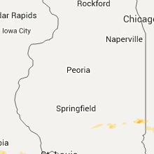
Hail Map for Tuesday, April 26, 2016

Number of Impacted Households on 4/26/2016
0
Impacted by 1" or Larger Hail
0
Impacted by 1.75" or Larger Hail
0
Impacted by 2.5" or Larger Hail
Square Miles of Populated Area Impacted on 4/26/2016
0
Impacted by 1" or Larger Hail
0
Impacted by 1.75" or Larger Hail
0
Impacted by 2.5" or Larger Hail


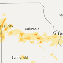


Cities Most Affected by Hail Storms of 4/26/2016
| Hail Size | Demographics of Zip Codes Affected | ||||||
|---|---|---|---|---|---|---|---|
| City | Count | Average | Largest | Pop Density | House Value | Income | Age |
| Wichita, KS | 9 | 1.81 | 2.00 | 2070 | $71k | $39.7k | 33.2 |
| Waterville, KS | 5 | 2.50 | 3.00 | 7 | $51k | $32.3k | 44.0 |
| Bremen, KS | 3 | 4.00 | 5.00 | 5 | $53k | $33.1k | 45.7 |
| Marysville, KS | 4 | 2.13 | 2.50 | 20 | $60k | $33.8k | 44.0 |
| Blue Rapids, KS | 2 | 2.13 | 2.50 | 11 | $31k | $32.0k | 44.2 |
| Deshler, NE | 2 | 2.13 | 2.50 | 5 | $33k | $30.7k | 46.7 |
| Sonora, TX | 2 | 2.13 | 2.50 | 2 | $50k | $35.0k | 38.9 |
| Crowell, TX | 2 | 2.13 | 2.50 | 1 | $26k | $25.6k | 46.8 |
| Lancaster, KS | 2 | 2.00 | 2.25 | 11 | $49k | $37.3k | 41.8 |
| New Bloomfield, MO | 2 | 2.00 | 2.00 | 39 | $86k | $43.3k | 39.5 |
| Topeka, KS | 2 | 1.75 | 1.75 | 152 | $123k | $63.5k | 41.9 |
| Superior, NE | 2 | 1.75 | 1.75 | 16 | $36k | $26.9k | 51.0 |
| Chillicothe, TX | 2 | 1.75 | 1.75 | 3 | $26k | $28.7k | 41.5 |
| Clearwater, KS | 2 | 1.75 | 1.75 | 46 | $99k | $52.0k | 39.0 |
| Tipton, OK | 2 | 1.75 | 1.75 | 3 | $34k | $25.2k | 43.0 |
| Vernon, TX | 2 | 1.75 | 1.75 | 27 | $47k | $29.4k | 37.8 |
| Harrisburg, IL | 1 | 3.00 | 3.00 | 95 | $52k | $29.6k | 41.2 |
| Hanover, KS | 1 | 3.00 | 3.00 | 9 | $37k | $34.0k | 42.8 |
| Haysville, KS | 1 | 2.00 | 2.00 | 532 | $75k | $48.5k | 35.4 |
| Peck, KS | 1 | 2.00 | 2.00 | 29 | $109k | $53.8k | 44.6 |
| Bonnots Mill, MO | 1 | 2.00 | 2.00 | 25 | $100k | $43.6k | 39.5 |
| Odell, NE | 1 | 2.00 | 2.00 | 5 | $47k | $34.6k | 46.6 |
| Independence, MO | 1 | 1.75 | 1.75 | 828 | $81k | $43.9k | 32.1 |
| Hardy, NE | 1 | 1.75 | 1.75 | 4 | $20k | $33.8k | 46.6 |
| Haskell, TX | 1 | 1.75 | 1.75 | 11 | $36k | $23.6k | 42.6 |
| Butler, OK | 1 | 1.75 | 1.75 | 2 | $28k | $29.7k | 49.8 |
| Blanchester, OH | 1 | 1.75 | 1.75 | 132 | $91k | $40.5k | 39.2 |
| Alva, OK | 1 | 1.75 | 1.75 | 10 | $53k | $30.1k | 31.9 |
| Harrisville, WV | 1 | 1.75 | 1.75 | 30 | $61k | $26.2k | 45.0 |
| Ellenboro, WV | 1 | 1.75 | 1.75 | 18 | $53k | $33.8k | 44.3 |
| Bucyrus, KS | 1 | 1.75 | 1.75 | 43 | $155k | $59.7k | 43.4 |
| Auburn, WV | 1 | 1.75 | 1.75 | 10 | $33k | $15.4k | 45.3 |
| Olsburg, KS | 1 | 1.75 | 1.75 | 4 | $55k | $41.6k | 42.2 |
| Snyder, OK | 1 | 1.75 | 1.75 | 14 | $42k | $26.3k | 41.1 |
| Fairview, OK | 1 | 1.75 | 1.75 | 10 | $52k | $30.5k | 44.8 |
| Bland, MO | 1 | 1.75 | 1.75 | 14 | $48k | $32.0k | 45.9 |
| Newport, KY | 1 | 1.75 | 1.75 | 774 | $121k | $47.3k | 39.4 |
| Fairview, KS | 1 | 1.75 | 1.75 | 6 | $35k | $34.6k | 50.0 |
| Conway Springs, KS | 1 | 1.75 | 1.75 | 15 | $65k | $42.0k | 35.7 |
| Myra, TX | 1 | 1.75 | 1.75 | 0 | $42k | $46.8k | 37.2 |
| Arnett, OK | 1 | 1.75 | 1.75 | 1 | $30k | $28.2k | 45.5 |
| Hermleigh, TX | 1 | 1.75 | 1.75 | 5 | $35k | $29.9k | 46.3 |
| Kiowa, KS | 1 | 1.75 | 1.75 | 10 | $32k | $32.8k | 47.3 |
| Morrow, OH | 1 | 1.75 | 1.75 | 225 | $130k | $51.4k | 37.9 |
| Cross Plains, TX | 1 | 1.75 | 1.75 | 10 | $34k | $23.0k | 47.8 |
| Olpe, KS | 1 | 1.75 | 1.75 | 5 | $72k | $40.6k | 42.9 |
| Paris, IL | 1 | 1.75 | 1.75 | 47 | $56k | $35.0k | 42.9 |
| Racine, OH | 1 | 1.75 | 1.75 | 46 | $66k | $31.3k | 42.1 |
Hail and Wind Damage Spotted on 4/26/2016
Filter by Report Type:Hail ReportsWind Reports
States Impacted
Kansas, Missouri, Oklahoma, Ohio, Illinois, Indiana, Texas, Kentucky, West Virginia, NebraskaKansas
| Local Time | Report Details |
|---|---|
| 7:03 AM CDT | Golf Ball sized hail reported near Lancaster, KS, 50.1 miles NW of Kansas City, MO, pea to golf ball size hail reported |
| 7:10 AM CDT | Hen Egg sized hail reported near Lancaster, KS, 50.1 miles NW of Kansas City, MO, 2.25 inch hail reported. |
| 7:19 AM CDT | Ping Pong Ball sized hail reported near Kansas City, KS, 13.9 miles W of Kansas City, MO |
| 7:51 AM CDT | Em reported grain roof blown off and thrown approximately 600 feet. time estimated by rada in jefferson county KS, 44.4 miles WNW of Kansas City, MO |
| 2:53 PM CDT | Quarter sized hail reported near Bluff City, KS, 52.6 miles SSW of Wichita, KS |
| 2:58 PM CDT | Quarter sized hail reported near Caldwell, KS, 50.1 miles SSW of Wichita, KS, report from kake tv. |
| 3:02 PM CDT | Half Dollar sized hail reported near Caldwell, KS, 50.1 miles SSW of Wichita, KS, report via kake tv spotter. |
| 3:27 PM CDT | Half Dollar sized hail reported near Caldwell, KS, 40.7 miles SSW of Wichita, KS, report via spotter network. |
| 3:28 PM CDT | Quarter sized hail reported near Ogden, KS, 9.3 miles WSW of Manhattan, KS, quarter size hail reported by em. |
| 3:43 PM CDT | Quarter sized hail reported near Manhattan, KS, 2.2 miles WNW of Manhattan, KS |
| 4:00 PM CDT | Golf Ball sized hail reported near Conway Springs, KS, 21.7 miles SW of Wichita, KS, hail ranging from quarter to golf ball size. |
| 4:00 PM CDT | Half Dollar sized hail reported near Wichita, KS, 6.8 miles W of Wichita, KS, quarter to half dollars near 135th and kellogg. |
| 4:01 PM CDT | Golf Ball sized hail reported near Olsburg, KS, 15.3 miles N of Manhattan, KS |
| 4:08 PM CDT | Quarter sized hail reported near Olsburg, KS, 17.7 miles NNW of Manhattan, KS, covering the ground |
| 4:08 PM CDT | Golf Ball sized hail reported near Wichita, KS, 6.8 miles W of Wichita, KS, report via picture on facebook. |
| 4:09 PM CDT | Golf Ball sized hail reported near Wichita, KS, 8.2 miles WNW of Wichita, KS, measured by off duty nws employee near 21st and 119th. |
| 4:15 PM CDT | Half Dollar sized hail reported near Alta Vista, KS, 22.3 miles S of Manhattan, KS |
| 4:17 PM CDT | Half Dollar sized hail reported near Wakarusa, KS, 44.9 miles ESE of Manhattan, KS, half dollar size hail reported by em |
| 4:22 PM CDT | Quarter sized hail reported near Clearwater, KS, 17.7 miles SSW of Wichita, KS, relayed from storm spotter. |
| 4:23 PM CDT | Quarter sized hail reported near Topeka, KS, 36.4 miles ESE of Manhattan, KS |
| 4:24 PM CDT | Quarter sized hail reported near Alma, KS, 17.5 miles SSE of Manhattan, KS |
| 4:26 PM CDT | Quarter sized hail reported near Topeka, KS, 37.3 miles ESE of Manhattan, KS |
| 4:30 PM CDT | Hen Egg sized hail reported near Waterville, KS, 36.7 miles NNW of Manhattan, KS |
| 4:31 PM CDT | Golf Ball sized hail reported near Blue Rapids, KS, 35 miles N of Manhattan, KS |
| 4:35 PM CDT | Tennis Ball sized hail reported near Blue Rapids, KS, 35 miles N of Manhattan, KS |
| 4:36 PM CDT | Quarter sized hail reported near Bern, KS, 64.3 miles NNE of Manhattan, KS |
| 4:36 PM CDT | Tennis Ball sized hail reported near Waterville, KS, 36.7 miles NNW of Manhattan, KS |
| 4:36 PM CDT | Tea Cup sized hail reported near Waterville, KS, 36.7 miles NNW of Manhattan, KS, photo evidence of hail at least 3 inches in diameter. |
| 4:37 PM CDT | Quarter sized hail reported near Elbing, KS, 27.4 miles NNE of Wichita, KS, relayed from trained spotter. |
| 4:38 PM CDT | Quarter sized hail reported near Atlanta, KS, 30.6 miles ESE of Wichita, KS |
| 4:45 PM CDT | Quarter sized hail reported near Topeka, KS, 36.4 miles ESE of Manhattan, KS |
| 4:48 PM CDT | Hen Egg sized hail reported near Marysville, KS, 42.9 miles N of Manhattan, KS |
| 4:48 PM CDT | Tennis Ball sized hail reported near Marysville, KS, 45.2 miles N of Manhattan, KS, photo evidence of 2.5 inch diameter hail south of marysville. |
| 4:49 PM CDT | Tennis Ball sized hail reported near Waterville, KS, 38.7 miles NNW of Manhattan, KS, windows broken out of home. |
| 4:49 PM CDT | Quarter sized hail reported near Marysville, KS, 47.4 miles N of Manhattan, KS |
| 4:49 PM CDT | Tennis Ball sized hail reported near Waterville, KS, 36 miles NNW of Manhattan, KS |
| 4:50 PM CDT | Quarter sized hail reported near Anthony, KS, 50.9 miles SW of Wichita, KS |
| 4:51 PM CDT | Storm damage reported in geary county KS, 20.6 miles S of Manhattan, KS |
| 4:55 PM CDT | Golf Ball sized hail reported near Topeka, KS, 36.9 miles ESE of Manhattan, KS |
| 4:56 PM CDT | Golf Ball sized hail reported near Clearwater, KS, 13.3 miles SSW of Wichita, KS |
| 4:57 PM CDT | Quarter sized hail reported near Topeka, KS, 38.7 miles ESE of Manhattan, KS |
| 4:57 PM CDT | Quarter sized hail reported near Washington, KS, 49.6 miles NNW of Manhattan, KS |
| 5:00 PM CDT | Hen Egg sized hail reported near Peck, KS, 14.3 miles S of Wichita, KS, delayed report. |
| 5:00 PM CDT | Grapefruit sized hail reported near Bremen, KS, 52.6 miles NNW of Manhattan, KS |
| 5:00 PM CDT | Softball sized hail reported near Bremen, KS, 52.6 miles NNW of Manhattan, KS, 5 inch hail measured. report based on photo evidence via social media. |
| 5:06 PM CDT | Quarter sized hail reported near Clyde, KS, 55.6 miles WNW of Manhattan, KS |
| 5:06 PM CDT | Golf Ball sized hail reported near Wichita, KS, 7.1 miles SSW of Wichita, KS, reported near 55th street and ridge road. |
| 5:10 PM CDT | Golf Ball sized hail reported near Clearwater, KS, 14 miles SSW of Wichita, KS |
| 5:12 PM CDT | Tea Cup sized hail reported near Hanover, KS, 51.9 miles NNW of Manhattan, KS, via twitter. |
| 5:15 PM CDT | Quarter sized hail reported near Wichita, KS, 5.3 miles S of Wichita, KS, hail reported at west 47th and south boradway in wichita. |
| 5:15 PM CDT | Half Dollar sized hail reported near Waterville, KS, 36.7 miles NNW of Manhattan, KS |
| 5:15 PM CDT | Golf Ball sized hail reported near Topeka, KS, 34 miles E of Manhattan, KS |
| 5:17 PM CDT | Half Dollar sized hail reported near Silver Lake, KS, 37 miles E of Manhattan, KS |
| 5:20 PM CDT | Quarter sized hail reported near Rossville, KS, 32.9 miles E of Manhattan, KS, 1 inch hail reported by public. |
| 5:22 PM CDT | Golf Ball sized hail reported near Wichita, KS, 6.2 miles SSE of Wichita, KS, near 55th and broadway. reported via twitter. |
| 5:25 PM CDT | Hen Egg sized hail reported near Haysville, KS, 9.6 miles S of Wichita, KS |
| 5:25 PM CDT | Hen Egg sized hail reported near Marysville, KS, 44.8 miles N of Manhattan, KS |
| 5:27 PM CDT | Hen Egg sized hail reported near Marysville, KS, 43.5 miles N of Manhattan, KS, radar estimated time |
| 5:29 PM CDT | Ping Pong Ball sized hail reported near Wichita, KS, 4.2 miles E of Wichita, KS, reported in college hill. |
| 5:32 PM CDT | Quarter sized hail reported near Wichita, KS, 7.7 miles NE of Wichita, KS, measured by employee at kfdi. |
| 5:32 PM CDT | Golf Ball sized hail reported near Wichita, KS, 6.2 miles SSE of Wichita, KS, pawnee and interstate 135. |
| 5:33 PM CDT | Half Dollar sized hail reported near Wichita, KS, 2 miles ESE of Wichita, KS, reported at hillside and douglas. |
| 5:33 PM CDT | Tea Cup sized hail reported near Bremen, KS, 50.7 miles NNW of Manhattan, KS |
| 5:35 PM CDT | Quarter sized hail reported near Bremen, KS, 54.1 miles N of Manhattan, KS |
| 5:35 PM CDT | Hen Egg sized hail reported near Wichita, KS, 2 miles ESE of Wichita, KS, reported at douglas and hillside. |
| 5:39 PM CDT | Ping Pong Ball sized hail reported near Wichita, KS, 2.4 miles W of Wichita, KS |
| 5:45 PM CDT | Ping Pong Ball sized hail reported near Wichita, KS, 6.9 miles NE of Wichita, KS, report via soical media. corrected for time. |
| 5:45 PM CDT | Ping Pong Ball sized hail reported near Wichita, KS, 6.2 miles NE of Wichita, KS, delayed report. received via twitter. |
| 5:47 PM CDT | Ping Pong Ball sized hail reported near Wichita, KS, 6 miles ENE of Wichita, KS, reported at oxford cir and rock rd. |
| 5:48 PM CDT | Quarter sized hail reported near Wichita, KS, 6.2 miles NE of Wichita, KS |
| 5:49 PM CDT | Golf Ball sized hail reported near Fairview, KS, 63.4 miles NE of Manhattan, KS |
| 5:54 PM CDT | Quarter sized hail reported near Mayfield, KS, 32.8 miles SSW of Wichita, KS, reported at 20th and caldwell road. |
| 5:58 PM CDT | Quarter sized hail reported near Wichita, KS, 6.8 miles W of Wichita, KS, near central and ridge. |
| 6:13 PM CDT | Ping Pong Ball sized hail reported near Wichita, KS, 6.9 miles NE of Wichita, KS, report via soical media. |
| 6:22 PM CDT | Quarter sized hail reported near Jewell, KS, 83.2 miles NE of Hays, KS, trained spotter reported hail up to the size of quarters one half mile west of jewell. |
| 6:25 PM CDT | Half Dollar sized hail reported near Conway Springs, KS, 25.1 miles SW of Wichita, KS, quarter to half dollar size hail reported at firestation to the east of conway springs. |
| 6:36 PM CDT | Half Dollar sized hail reported near Clearwater, KS, 15.2 miles SW of Wichita, KS |
| 6:45 PM CDT | Ping Pong Ball sized hail reported near Clearwater, KS, 13.1 miles SW of Wichita, KS |
| 6:51 PM CDT | Half Dollar sized hail reported near Wichita, KS, 6.2 miles SSE of Wichita, KS, near 71st and broadway. courtesy kwch storm chaser. |
| 6:52 PM CDT | Ping Pong Ball sized hail reported near Wichita, KS, 6.2 miles SSE of Wichita, KS, near hydraulic and macarthur. |
| 6:52 PM CDT | Golf Ball sized hail reported near Wichita, KS, 6.2 miles SSE of Wichita, KS, near south meridian and interstate 235. |
| 6:54 PM CDT | Golf Ball sized hail reported near Wichita, KS, 5.9 miles SE of Wichita, KS, official mcconnell observation. |
| 6:56 PM CDT | Quarter sized hail reported near Wichita, KS, 6 miles WSW of Wichita, KS, official observation at the airport. |
| 6:56 PM CDT | Hen Egg sized hail reported near Wichita, KS, 0.3 miles NW of Wichita, KS |
| 6:59 PM CDT | Quarter sized hail reported near Viola, KS, 22 miles SW of Wichita, KS |
| 6:59 PM CDT | Quarter sized hail reported near Wichita, KS, 6 miles ENE of Wichita, KS, reported at oxford cir and rock rd. |
| 6:59 PM CDT | Quarter sized hail reported near Courtland, KS, 68.2 miles SSE of Grand Island, NE |
| 7:06 PM CDT | Half Dollar sized hail reported near Wichita, KS, 6.2 miles SSE of Wichita, KS, near hydraulic and lincoln. |
| 7:10 PM CDT | Golf Ball sized hail reported near Kiowa, KS, 67.8 miles NE of Woodward, OK |
| 7:13 PM CDT | Quarter sized hail reported near Wichita, KS, 4.2 miles E of Wichita, KS, near central and greenwich. courtesy of ksn. |
| 7:15 PM CDT | Ping Pong Ball sized hail reported near Benton, KS, 16.2 miles NE of Wichita, KS |
| 7:24 PM CDT | Quarter sized hail reported near Formoso, KS, 81.1 miles SSE of Grand Island, NE, trained spotter reports hail up to the size of quarters in formoso. |
| 7:35 PM CDT | Storm damage reported in butler county KS, 16.8 miles E of Wichita, KS |
| 8:07 PM CDT | Golf Ball sized hail reported near Olpe, KS, 55.9 miles NW of Chanute, KS |
| 8:13 PM CDT | Quarter sized hail reported near Cottonwood Falls, KS, 55.8 miles S of Manhattan, KS |
| 8:55 PM CDT | Quarter sized hail reported near Burlington, KS, 41.8 miles NNW of Chanute, KS |
| 8:58 PM CDT | Storm damage reported in coffey county KS, 45.2 miles NNW of Chanute, KS |
| 9:11 PM CDT | Quarter sized hail reported near Waverly, KS, 49.9 miles N of Chanute, KS, quarter size hail and winds to around 60 mph estimated on i-35. |
| 9:34 PM CDT | Storm damage reported in franklin county KS, 49.8 miles SW of Kansas City, MO |
| 9:35 PM CDT | Storm damage reported in franklin county KS, 53.7 miles SW of Kansas City, MO |
| 9:45 PM CDT | 4 inch diameter limbs snappe in franklin county KS, 49.7 miles SW of Kansas City, MO |
| 9:47 PM CDT | Quarter sized hail reported near Ottawa, KS, 49 miles SW of Kansas City, MO |
| 9:48 PM CDT | Ping Pong Ball sized hail reported near Ottawa, KS, 47.7 miles SW of Kansas City, MO |
| 9:54 PM CDT | Quarter sized hail reported near Olathe, KS, 19.1 miles SW of Kansas City, MO |
| 9:58 PM CDT | A few trees down in linn county KS, 51.3 miles NNE of Chanute, KS |
| 10:08 PM CDT | Quarter sized hail reported near Paola, KS, 41.4 miles SSW of Kansas City, MO |
| 10:08 PM CDT | Ping Pong Ball sized hail reported near Edgerton, KS, 34.4 miles SW of Kansas City, MO |
| 10:21 PM CDT | Quarter sized hail reported near Shawnee, KS, 13.8 miles WSW of Kansas City, MO |
| 10:23 PM CDT | Numerous trees down from louisburg east northeast to mo state lin in miami county KS, 32.8 miles S of Kansas City, MO |
| 10:25 PM CDT | Quarter sized hail reported near Overland Park, KS, 17.5 miles SSW of Kansas City, MO |
| 10:26 PM CDT | Quarter sized hail reported near Olathe, KS, 22.8 miles SSW of Kansas City, MO |
| 10:36 PM CDT | Golf Ball sized hail reported near Bucyrus, KS, 26.5 miles S of Kansas City, MO |
| 10:55 PM CDT | Quarter sized hail reported near Altoona, KS, 15.5 miles SW of Chanute, KS |
| 10:55 PM CDT | Storm damage reported in montgomery county KS, 34.3 miles SSW of Chanute, KS |
| 10:55 PM CDT | Storm damage reported in montgomery county KS, 34.3 miles SSW of Chanute, KS |
| 11:16 PM CDT | Estimated 60-70mph wind gus in labette county KS, 45 miles SSE of Chanute, KS |
| 11:19 PM CDT | Power lines down. lines down across highway 160. power out in dennis and west parson in labette county KS, 32.6 miles S of Chanute, KS |
| 11:22 PM CDT | Storm damage reported in labette county KS, 27.6 miles SSE of Chanute, KS |
| 11:24 PM CDT | Semi pulling doubles was blown over on highway 400 near the montgomery and wilson county lin in wilson county KS, 25 miles SW of Chanute, KS |
| 11:25 PM CDT | Structure damage to building at highway 400 and wallace road. power out across much of northern labette count in labette county KS, 29.2 miles SE of Chanute, KS |
| 11:51 PM CDT | Several buildings damaged... large trees down on south side of girard. damage to animal hospital in crawford county KS, 35.6 miles ESE of Chanute, KS |
| 12:16 AM CDT | Carport blown apart and siding blown off house in cherokee county KS, 59.1 miles SE of Chanute, KS |
Missouri
| Local Time | Report Details |
|---|---|
| 7:20 AM CDT | Quarter sized hail reported near Kansas City, MO, 10.8 miles NW of Kansas City, MO |
| 7:35 AM CDT | Quarter sized hail reported near Kansas City, MO, 13.1 miles N of Kansas City, MO |
| 7:39 AM CDT | Quarter sized hail reported near Kansas City, MO, 11.3 miles NNW of Kansas City, MO, dime to quarter sized hail. |
| 7:47 AM CDT | Half Dollar sized hail reported near Edgerton, MO, 28.2 miles N of Kansas City, MO |
| 7:50 AM CDT | Quarter sized hail reported near Trimble, MO, 26.7 miles N of Kansas City, MO |
| 8:07 AM CDT | Half Dollar sized hail reported near Kansas City, MO, 11.4 miles NNW of Kansas City, MO |
| 8:09 AM CDT | Quarter sized hail reported near Plattsburg, MO, 32.2 miles NNE of Kansas City, MO, pea to quarter size hail... very heavy on ground. |
| 8:12 AM CDT | Storm damage reported in buchanan county MO, 47.5 miles NNW of Kansas City, MO |
| 8:20 AM CDT | A few powerlines down near rushville in buchanan county MO, 40.9 miles NW of Kansas City, MO |
| 8:22 AM CDT | Quarter sized hail reported near Blue Springs, MO, 17.3 miles ESE of Kansas City, MO, penny to quarter size. |
| 8:37 AM CDT | Dock collapse on smithville lake in clay county MO, 19.8 miles N of Kansas City, MO |
| 8:42 AM CDT | Ping Pong Ball sized hail reported near Liberty, MO, 13.4 miles NE of Kansas City, MO, quarter to ping pong size hail... really flat though. 150 hwy and 291 intersection. |
| 8:42 AM CDT | Golf Ball sized hail reported near Independence, MO, 16.3 miles E of Kansas City, MO, reported at lake city ammunition plant |
| 8:44 AM CDT | Also quarter sized hail with wind in clinton county MO, 25.3 miles N of Kansas City, MO |
| 8:47 AM CDT | Quarter sized hail reported near Lees Summit, MO, 17.2 miles SE of Kansas City, MO, 50th and todd george rd... pea to quarter size hail. |
| 9:00 AM CDT | Half Dollar sized hail reported near Blue Springs, MO, 15 miles ESE of Kansas City, MO |
| 9:04 AM CDT | Power line down at 39th and gudgel in jackson county MO, 12.6 miles E of Kansas City, MO |
| 9:07 AM CDT | Quarter sized hail reported near Richmond, MO, 35.1 miles ENE of Kansas City, MO, peas size to quarter size hail... still coming down. |
| 9:10 AM CDT | Quarter sized hail reported near Independence, MO, 12.6 miles E of Kansas City, MO, via twitter |
| 9:13 AM CDT | Half Dollar sized hail reported near Odessa, MO, 34.8 miles ESE of Kansas City, MO, via twitter |
| 9:27 AM CDT | Quarter sized hail reported near Centerview, MO, 41.7 miles ESE of Kansas City, MO |
| 10:11 AM CDT | Quarter sized hail reported near Whiteman Air Force Base, MO, 61.3 miles ESE of Kansas City, MO |
| 10:28 AM CDT | Significant wind damage from the north side of sedalia to near the sedalia airport. a roof was ripped off a business on the north side of sedalia...4 power poles were s in pettis county MO, 50.9 miles WSW of Columbia, MO |
| 10:32 AM CDT | Em reported 50-60 mph wind and hail to dime sized in pettis county MO, 52.4 miles WSW of Columbia, MO |
| 10:52 AM CDT | Severe thunderstorm wind gusts observed by a morgan county sheriffs deputy along highway 5 in morgan county MO, 41.8 miles WSW of Columbia, MO |
| 10:53 AM CDT | Also 1 inch diameter hail in pettis county MO, 44.9 miles WSW of Columbia, MO |
| 11:12 AM CDT | Half Dollar sized hail reported near Jamestown, MO, 14.2 miles SSW of Columbia, MO, quarter to half dollar sized hail. |
| 11:12 AM CDT | Powerlines down along highway 5 in morgan county MO, 34.9 miles SW of Columbia, MO |
| 11:13 AM CDT | Several large trees dow in morgan county MO, 45.2 miles SW of Columbia, MO |
| 11:13 AM CDT | Several large trees dow in morgan county MO, 39.9 miles SW of Columbia, MO |
| 11:22 AM CDT | Storm damage reported in moniteau county MO, 32.9 miles SW of Columbia, MO |
| 11:26 AM CDT | Quarter sized hail reported near Latham, MO, 32.9 miles SW of Columbia, MO |
| 11:26 AM CDT | Storm damage reported in moniteau county MO, 32.9 miles SW of Columbia, MO |
| 11:35 AM CDT | Hen Egg sized hail reported near New Bloomfield, MO, 17.8 miles SSE of Columbia, MO, some siding damage and tree damage from hail. most of the hail was around an inch in diameter. |
| 11:37 AM CDT | Storm damage reported in boone county MO, 10.4 miles SE of Columbia, MO |
| 11:44 AM CDT | Quarter sized hail reported near Fulton, MO, 20.5 miles ESE of Columbia, MO, dime to quarter sized hail |
| 11:47 AM CDT | Quarter sized hail reported near Fulton, MO, 21.9 miles ESE of Columbia, MO |
| 11:50 AM CDT | Hen Egg sized hail reported near New Bloomfield, MO, 17.2 miles SE of Columbia, MO |
| 11:55 AM CDT | Hen Egg sized hail reported near Bonnots Mill, MO, 34.6 miles SE of Columbia, MO, time estimated by radar |
| 11:59 AM CDT | Quarter sized hail reported near Eldon, MO, 43.6 miles SSW of Columbia, MO |
| 12:00 PM CDT | Telephone lines blown dow in audrain county MO, 29.1 miles ENE of Columbia, MO |
| 12:13 PM CDT | Powerlines down... siding blown off house in callaway county MO, 31.7 miles SE of Columbia, MO |
| 12:35 PM CDT | Several large tree limbs blown dow in st. charles county MO, 39.1 miles W of Saint Louis, MO |
| 12:44 PM CDT | Storm damage reported in gasconade county MO, 51.3 miles ESE of Columbia, MO |
| 12:45 PM CDT | Golf Ball sized hail reported near Bland, MO, 46 miles N of Salem, MO |
| 12:55 PM CDT | Several trees blown down...between 15 and 25 feet tal in montgomery county MO, 53.1 miles E of Columbia, MO |
| 12:56 PM CDT | Quarter sized hail reported near Owensville, MO, 49.2 miles N of Salem, MO |
| 1:05 PM CDT | On u.s. highway 5 in franklin county MO, 49.8 miles WSW of Saint Louis, MO |
| 1:15 PM CDT | Trees blown over on highway t near highway tt. some power lines blown dow in st. charles county MO, 36.9 miles W of Saint Louis, MO |
| 1:20 PM CDT | Tree damage near st. albans north of highway t. time approximat in franklin county MO, 29.4 miles W of Saint Louis, MO |
| 1:20 PM CDT | Delayed report of trees down near treloar. time estimate in warren county MO, 53.6 miles W of Saint Louis, MO |
| 1:25 PM CDT | Large tree limb dow in franklin county MO, 44.2 miles W of Saint Louis, MO |
| 1:30 PM CDT | Quarter sized hail reported near Villa Ridge, MO, 38.4 miles WSW of Saint Louis, MO |
| 1:30 PM CDT | Numerous trees down in warren county MO, 43.6 miles WNW of Saint Louis, MO |
| 1:35 PM CDT | Several large tree limbs blown down near intersection of foristell road and highway in st. charles county MO, 37.3 miles W of Saint Louis, MO |
| 1:40 PM CDT | Large tree uprooted in st. louis county MO, 20.6 miles W of Saint Louis, MO |
| 1:49 PM CDT | Hail covering groun in st. louis county MO, 25.4 miles WSW of Saint Louis, MO |
| 1:52 PM CDT | Storm damage reported in st. louis county MO, 23.4 miles W of Saint Louis, MO |
| 1:55 PM CDT | Widespread tree damage. flag pole and mailbox pole snapped in half. large tree blown over and numerous large brances blown dow in st. charles county MO, 24 miles WNW of Saint Louis, MO |
| 1:55 PM CDT | Widespread tree damage. flag pole and mailbox pole snapped in half. large tree blown over and numerous large brances blown dow in st. charles county MO, 24 miles WNW of Saint Louis, MO |
| 2:00 PM CDT | Quarter sized hail reported near Eureka, MO, 23.9 miles WSW of Saint Louis, MO |
| 2:00 PM CDT | Ping Pong Ball sized hail reported near Dittmer, MO, 33.2 miles SW of Saint Louis, MO, delayed report of ping pong ball size hail in dittmer earlier this aftn |
| 2:08 PM CDT | Quarter sized hail reported near Maryland Heights, MO, 15.2 miles WNW of Saint Louis, MO, near intersection of page avenue and lindbergh blvd. |
| 2:10 PM CDT | Several very large trees blown down. one tree was uproote in st. louis county MO, 8.2 miles W of Saint Louis, MO |
| 2:17 PM CDT | Storm damage reported in st. louis county MO, 13 miles NW of Saint Louis, MO |
| 2:19 PM CDT | Multiple limbs down over roadways around 6 inches in diameter. time estimated from rada in st. louis county MO, 13.6 miles NW of Saint Louis, MO |
| 2:29 PM CDT | Storm damage reported in st. charles county MO, 24 miles NNW of Saint Louis, MO |
| 4:06 PM CDT | Quarter sized hail reported near Fair Grove, MO, 14.8 miles NE of Springfield, MO, quarter size hail farm road 225 north of farm road 22 |
| 4:20 PM CDT | Quarter sized hail reported near Marshfield, MO, 22.7 miles ENE of Springfield, MO, quarter size hail 1 mile northwest of marshfield |
| 4:27 PM CDT | Quarter sized hail reported near Marshfield, MO, 22.9 miles ENE of Springfield, MO, quarter size hail in marshfield |
| 4:30 PM CDT | Quarter sized hail reported near Marshfield, MO, 25.5 miles ENE of Springfield, MO, quarter size hail southeast of marshfield |
| 4:46 PM CDT | Quarter sized hail reported near Marshfield, MO, 29.4 miles ENE of Springfield, MO, quarter size hail reported along 38 highway near high praire |
| 4:53 PM CDT | Quarter sized hail reported near Marshfield, MO, 30.9 miles E of Springfield, MO, quarter size hail wnw of duncan |
| 5:23 PM CDT | Storm damage reported in butler county MO, 60.7 miles SW of Cape Girardeau, MO |
| 10:41 PM CDT | Storm damage reported in cass county MO, 22.8 miles SSE of Kansas City, MO |
| 10:44 PM CDT | Semi overturned at 2 highway and state line...heard on police scanner in cass county MO, 33.3 miles S of Kansas City, MO |
| 10:53 PM CDT | Storm damage reported in cass county MO, 22.8 miles SSE of Kansas City, MO |
| 11:14 PM CDT | Wind damaged a brick structure unknown severity in liberal in barton county MO, 51.8 miles E of Chanute, KS |
| 11:25 PM CDT | Estimated 60 mph winds reported via emergency management in vernon county MO, 61.3 miles E of Chanute, KS |
| 11:35 PM CDT | Roof blown off house with other houses and debris over the block on gardendale road in jasper county MO, 56.3 miles W of Springfield, MO |
| 12:14 AM CDT | Wind damaged a brick structure unknown severity in liberal in barton county MO, 51.8 miles E of Chanute, KS |
| 12:21 AM CDT | Trees and power lines down in newton county MO, 74.3 miles SE of Chanute, KS |
| 12:25 AM CDT | Trees and power lines down in lamar. a rv was blown over along interstate 49 in barton county MO, 57.8 miles WNW of Springfield, MO |
| 12:25 AM CDT | Estimated 60 mph winds reported via emergency management in vernon county MO, 61.3 miles E of Chanute, KS |
| 12:25 AM CDT | Quarter sized hail reported near Anderson, MO, 79.8 miles WSW of Springfield, MO, quarter size hail reported via storm spotter relayed by em |
| 12:26 AM CDT | 64mph wind gust measured on home weather station sw of horton in vernon county MO, 61 miles ENE of Chanute, KS |
| 12:35 AM CDT | Roof blown off house with other houses and debris over the block on gardendale road in jasper county MO, 56.3 miles W of Springfield, MO |
| 12:40 AM CDT | Trees uprooted in liberal in barton county MO, 51.8 miles E of Chanute, KS |
| 12:40 AM CDT | Powerlines down at i-49 and us 60 in neosho in newton county MO, 64 miles WSW of Springfield, MO |
| 12:40 AM CDT | Tree down east of pineville on k highway in mcdonald county MO, 73.9 miles SW of Springfield, MO |
| 12:40 AM CDT | Tree down per law enforcement in jasper county MO, 63.5 miles W of Springfield, MO |
| 12:45 AM CDT | Tree limbs down in carthage in jasper county MO, 56.2 miles W of Springfield, MO |
| 12:48 AM CDT | 67mph wind gust measured at raws site in st. clair county MO, 61.2 miles NW of Springfield, MO |
| 1:00 AM CDT | Tree limb down on a vehicle in barry county MO, 58.6 miles SW of Springfield, MO |
| 1:10 AM CDT | Powerlines and partial tree down in monett in barry county MO, 40.5 miles WSW of Springfield, MO |
| 1:21 AM CDT | Tree fell into a house in lawrence county MO, 28.8 miles SW of Springfield, MO |
| 1:45 AM CDT | Tree down in republic off p highway in greene county MO, 12.1 miles WSW of Springfield, MO |
| 1:54 AM CDT | Minor tree damage with limbs down and windows broken out of a house on royal vista in stone county MO, 38.6 miles S of Springfield, MO |
| 1:55 AM CDT | Moderate roof damage to mulitple homes off of shawnee drive and village terrace drive in greene county MO, 6.3 miles SSW of Springfield, MO |
| 1:55 AM CDT | Power poles broken due to wind at ozark mt resort in stone county MO, 42.6 miles S of Springfield, MO |
| 1:55 AM CDT | Small to medium tree limbs down on shore line road in christian county MO, 9.9 miles SSE of Springfield, MO |
| 1:55 AM CDT | Numerous sporadic large trees and limbs down on 265 highway south of 376 near skyline road in taney county MO, 40.6 miles S of Springfield, MO |
| 2:00 AM CDT | Large tree down in downtown branson in taney county MO, 39.4 miles S of Springfield, MO |
| 2:00 AM CDT | Measured 60 mph winds at highway 14 and highway 160 in nixa in christian county MO, 11.7 miles S of Springfield, MO |
| 2:07 AM CDT | Tree into a house in hollister... no injuries in taney county MO, 40.8 miles S of Springfield, MO |
| 2:17 AM CDT | Moderate tree limbs down per fire dept at highway 160 and highway 76 in taney county MO, 37.7 miles SSE of Springfield, MO |
Oklahoma
| Local Time | Report Details |
|---|---|
| 10:23 AM CDT | Quarter sized hail reported near Wellston, OK, 33 miles ENE of Oklahoma City, OK |
| 10:58 AM CDT | Quarter sized hail reported near Meeker, OK, 30.5 miles E of Oklahoma City, OK, relayed from twitter. |
| 11:10 AM CDT | Quarter sized hail reported near Cushing, OK, 47.2 miles WSW of Tulsa, OK |
| 12:50 PM CDT | Quarter sized hail reported near Bristow, OK, 31.3 miles SW of Tulsa, OK, half inch to inch size hail on east side of bristow. |
| 3:14 PM CDT | Quarter sized hail reported near Meno, OK, 68 miles E of Woodward, OK |
| 3:15 PM CDT | Quarter sized hail reported near Meno, OK, 69.1 miles E of Woodward, OK |
| 3:29 PM CDT | Quarter sized hail reported near Goltry, OK, 72.4 miles E of Woodward, OK |
| 4:25 PM CDT | Quarter sized hail reported near Canton, OK, 43.6 miles SE of Woodward, OK |
| 4:32 PM CDT | Ping Pong Ball sized hail reported near Olustee, OK, 45.9 miles E of Childress, TX |
| 4:43 PM CDT | Quarter sized hail reported near Tipton, OK, 57.4 miles E of Childress, TX |
| 4:47 PM CDT | Quarter sized hail reported near Altus, OK, 51.2 miles ENE of Childress, TX |
| 5:09 PM CDT | Golf Ball sized hail reported near Tipton, OK, 56 miles NW of Wichita Falls, TX |
| 5:21 PM CDT | Ping Pong Ball sized hail reported near Fairview, OK, 52.5 miles E of Woodward, OK |
| 5:36 PM CDT | Golf Ball sized hail reported near Arnett, OK, 22.2 miles SSW of Woodward, OK |
| 5:36 PM CDT | Storm damage reported in ellis county OK, 22.8 miles SSW of Woodward, OK |
| 5:37 PM CDT | Storm damage reported in kiowa county OK, 57.8 miles NNW of Wichita Falls, TX |
| 5:38 PM CDT | Golf Ball sized hail reported near Snyder, OK, 55.7 miles NNW of Wichita Falls, TX |
| 5:41 PM CDT | Golf Ball sized hail reported near Fairview, OK, 52.5 miles ESE of Woodward, OK |
| 5:45 PM CDT | Large tree limbs dow in roger mills county OK, 53.8 miles SSW of Woodward, OK |
| 5:55 PM CDT | Storm damage reported in dewey county OK, 27.3 miles S of Woodward, OK |
| 6:00 PM CDT | Golf Ball sized hail reported near Butler, OK, 60 miles SSE of Woodward, OK |
| 6:09 PM CDT | Golf Ball sized hail reported near Tipton, OK, 56 miles NW of Wichita Falls, TX |
| 6:10 PM CDT | Storm damage reported in woodward county OK, 26.1 miles SE of Woodward, OK |
| 6:15 PM CDT | Storm damage reported in woodward county OK, 26.1 miles SE of Woodward, OK |
| 6:18 PM CDT | Quarter sized hail reported near Lamont, OK, 69.9 miles S of Wichita, KS |
| 6:30 PM CDT | Storm damage reported in dewey county OK, 33.1 miles SE of Woodward, OK |
| 6:30 PM CDT | Golf Ball sized hail reported near Alva, OK, 49.5 miles ENE of Woodward, OK |
| 6:52 PM CDT | Quarter sized hail reported near Carnegie, OK, 63.9 miles WSW of Oklahoma City, OK |
| 7:14 PM CDT | Quarter sized hail reported near Norman, OK, 19.7 miles S of Oklahoma City, OK |
| 7:20 PM CDT | Storm damage reported in alfalfa county OK, 61.5 miles ENE of Woodward, OK |
| 7:25 PM CDT | Storm damage reported in alfalfa county OK, 61.5 miles ENE of Woodward, OK |
| 7:25 PM CDT | Power lines down and trees blocking roa in alfalfa county OK, 62.8 miles ENE of Woodward, OK |
| 7:42 PM CDT | Storm damage reported in caddo county OK, 56.7 miles SW of Oklahoma City, OK |
| 7:55 PM CDT | Storm damage reported in comanche county OK, 41 miles N of Wichita Falls, TX |
| 7:57 PM CDT | Storm damage reported in comanche county OK, 47.9 miles N of Wichita Falls, TX |
| 7:57 PM CDT | Quarter sized hail reported near Cyril, OK, 56.6 miles SW of Oklahoma City, OK |
| 8:05 PM CDT | Storm damage reported in grady county OK, 42 miles SW of Oklahoma City, OK |
| 8:10 PM CDT | Storm damage reported in grady county OK, 38.8 miles SW of Oklahoma City, OK |
| 8:15 PM CDT | Powerlines dow in canadian county OK, 11.8 miles WSW of Oklahoma City, OK |
| 8:18 PM CDT | Quarter sized hail reported near Yukon, OK, 12.5 miles W of Oklahoma City, OK |
| 8:24 PM CDT | Storm damage reported in grady county OK, 25.2 miles SSW of Oklahoma City, OK |
| 8:25 PM CDT | Quarter sized hail reported near Oklahoma City, OK, 9.7 miles N of Oklahoma City, OK |
| 8:35 PM CDT | Quarter sized hail reported near Braman, OK, 52.9 miles S of Wichita, KS |
| 8:35 PM CDT | Storm damage reported in noble county OK, 65.3 miles WNW of Tulsa, OK |
| 8:36 PM CDT | Instrument used to measure is unknow in oklahoma county OK, 6.6 miles SSW of Oklahoma City, OK |
| 9:00 PM CDT | Storm damage reported in noble county OK, 65.3 miles WNW of Tulsa, OK |
| 9:14 PM CDT | Storm damage reported in lincoln county OK, 42.9 miles ENE of Oklahoma City, OK |
| 9:30 PM CDT | Storm damage reported in mcclain county OK, 51.5 miles SE of Oklahoma City, OK |
| 9:32 PM CDT | Storm damage reported in lincoln county OK, 46.9 miles SW of Tulsa, OK |
| 9:35 PM CDT | Storm damage reported in mcclain county OK, 51.5 miles SE of Oklahoma City, OK |
| 9:55 PM CDT | Powerline and trees downe in pontotoc county OK, 41.1 miles NW of Atoka, OK |
| 10:02 PM CDT | Estimated 60-70 mp in johnston county OK, 16.7 miles W of Atoka, OK |
| 10:03 PM CDT | Removed roof off of steel pipe welded car por in osage county OK, 35.9 miles NNW of Tulsa, OK |
| 10:15 PM CDT | Storm damage reported in hughes county OK, 48.8 miles NNW of Atoka, OK |
| 10:18 PM CDT | Interstate 44 and 49th west avenue in tulsa county OK, 1.6 miles SW of Tulsa, OK |
| 10:23 PM CDT | Highway 75 and i-44 in tulsa county OK, 4.3 miles ESE of Tulsa, OK |
| 10:23 PM CDT | Highway 412 and 49th west avenue in tulsa county OK, 1.6 miles SW of Tulsa, OK |
| 10:24 PM CDT | At 37th and jackson in tulsa county OK, 2.7 miles S of Tulsa, OK |
| 10:35 PM CDT | Storm damage reported in washington county OK, 52.7 miles N of Tulsa, OK |
| 11:04 PM CDT | On highway 69 in mcintosh county OK, 61.7 miles SSE of Tulsa, OK |
| 11:08 PM CDT | Storm damage reported in mcintosh county OK, 56.3 miles SSE of Tulsa, OK |
| 11:19 PM CDT | Storm damage reported in choctaw county OK, 42.1 miles SE of Atoka, OK |
| 11:45 PM CDT | Storm damage reported in mayes county OK, 55.2 miles ENE of Tulsa, OK |
| 12:00 AM CDT | Large trees down in cherokee county OK, 39.3 miles NW of Fort Smith, AR |
| 12:20 AM CDT | Spotter reported 75 mph wind in le flore county OK, 15.9 miles SW of Fort Smith, AR |
| 12:25 AM CDT | Trees reported down on stevens gap road in mccurtain county OK, 50.3 miles WNW of Nashville, AR |
Ohio
| Local Time | Report Details |
|---|---|
| 1:55 PM EDT | Storm damage reported in clinton county OH, 44.3 miles ENE of Cincinnati, OH |
| 2:34 PM EDT | Quarter sized hail reported near Crooksville, OH, 50.3 miles ESE of Columbus, OH, currently falling |
| 3:05 PM EDT | Quarter sized hail reported near Albany, OH, 61.4 miles NNW of Charleston, WV, most hail is dime size... however some quarter sized mixed in. heavy rain. |
| 3:24 PM EDT | Quarter sized hail reported near Cedarville, OH, 45.1 miles WSW of Columbus, OH, event occurred north of cedarville on route 72. |
| 3:42 PM EDT | Golf Ball sized hail reported near Racine, OH, 51.2 miles NNW of Charleston, WV, meigs county golf course. very heavy rain also. time estimated from radar |
| 3:53 PM EDT | Half Dollar sized hail reported near Mcconnelsville, OH, 65.5 miles ESE of Columbus, OH, social media report relayed via broadcast media - time estimated from radar |
| 4:05 PM EDT | Golf Ball sized hail reported near Morrow, OH, 27 miles NE of Cincinnati, OH, estimated golfball size hail |
| 4:22 PM EDT | Golf Ball sized hail reported near Blanchester, OH, 31.2 miles ENE of Cincinnati, OH |
| 4:27 PM EDT | Quarter sized hail reported near Blanchester, OH, 29.4 miles ENE of Cincinnati, OH |
| 4:30 PM EDT | Quarter sized hail reported near Blanchester, OH, 33.2 miles ENE of Cincinnati, OH |
| 5:06 PM EDT | Half Dollar sized hail reported near Hillsboro, OH, 43.1 miles E of Cincinnati, OH |
| 5:40 PM EDT | Quarter sized hail reported near Grove City, OH, 6.6 miles SSW of Columbus, OH |
| 6:04 PM EDT | Half Dollar sized hail reported near Cincinnati, OH, 9.7 miles ESE of Cincinnati, OH |
| 6:12 PM EDT | Quarter sized hail reported near Cincinnati, OH, 6.9 miles ESE of Cincinnati, OH, 1/2 to 1 inch hail. |
| 6:15 PM EDT | Quarter sized hail reported near Otway, OH, 69.3 miles E of Cincinnati, OH |
| 6:24 PM EDT | Trees down on sr 177 in preble county OH, 40.3 miles NNW of Cincinnati, OH |
| 6:30 PM EDT | Quarter sized hail reported near Grove City, OH, 7.3 miles SSW of Columbus, OH |
| 6:31 PM EDT | Quarter sized hail reported near Galloway, OH, 9.1 miles WSW of Columbus, OH |
| 6:36 PM EDT | Trees down on sr 725 in preble county OH, 36.9 miles NNW of Cincinnati, OH |
| 6:59 PM EDT | Quarter sized hail reported near North Bend, OH, 16.3 miles WNW of Cincinnati, OH |
| 7:22 PM EDT | Storm damage reported in hamilton county OH, 4.6 miles E of Cincinnati, OH |
| 7:33 PM EDT | Tree fell on home on creekwood bluffs r in clermont county OH, 15.4 miles ENE of Cincinnati, OH |
| 7:35 PM EDT | Quarter sized hail reported near Milford, OH, 12.8 miles ENE of Cincinnati, OH, 1 inch hail measured in milford. |
Illinois
| Local Time | Report Details |
|---|---|
| 2:25 PM CDT | Quarter sized hail reported near Fults, IL, 29.5 miles S of Saint Louis, MO |
| 2:54 PM CDT | Quarter sized hail reported near Sullivan, IL, 13.9 miles WNW of Mattoon, IL, swop report |
| 3:00 PM CDT | 4-6 inch diameter tree limbs dow in madison county IL, 17.3 miles NNE of Saint Louis, MO |
| 3:00 PM CDT | Earlier local storm report of multiple cars blown off i-64 near mile post 27 was erroneou in st. clair county IL, 25.1 miles ESE of Saint Louis, MO |
| 3:00 PM CDT | From county esda via ham radio operator. 50 foot tree... 30 inch in diameter...west of pawnee...dickee road and horse creek drive. also... another tree split down middle in sangamon county IL, 64.8 miles W of Mattoon, IL |
| 3:13 PM CDT | Quarter sized hail reported near Gays, IL, 7.2 miles W of Mattoon, IL, pea to quarter size hail for over 10 minutes. public report via wand-tv facebook page |
| 3:31 PM CDT | Power lines down at fushia rd and county line rd in perry county IL, 53 miles ESE of Saint Louis, MO |
| 3:31 PM CDT | One or two empty grain train cars were rolled over in perry county IL, 54.4 miles N of Cape Girardeau, MO |
| 3:51 PM CDT | Quarter sized hail reported near Du Quoin, IL, 54.8 miles NNE of Cape Girardeau, MO, reported between du quoin and tamaroa |
| 3:52 PM CDT | Golf Ball sized hail reported near Paris, IL, 37.9 miles ENE of Mattoon, IL, hail to golfball size reported via wtwo-tv and a public video on twitter |
| 3:59 PM CDT | Quarter sized hail reported near Du Quoin, IL, 54.8 miles NNE of Cape Girardeau, MO, intersection of us route 51 and il route 154 by sheriffs deputy |
| 4:00 PM CDT | Trees down in jefferson county IL, 69.5 miles E of Saint Louis, MO |
| 4:10 PM CDT | Quarter sized hail reported near Dahlgren, IL, 56.3 miles WNW of Evansville, IN, dime to quarter size hail |
| 4:30 PM CDT | Quarter sized hail reported near West Frankfort, IL, 51.7 miles NE of Cape Girardeau, MO |
| 4:37 PM CDT | Quarter sized hail reported near Golconda, IL, 48.7 miles E of Cape Girardeau, MO, marble to quarter size hail between dixon springs and glendale |
| 4:40 PM CDT | Trees and limbs blown down in flora. power also out in flor in clay county IL, 56.3 miles S of Mattoon, IL |
| 4:45 PM CDT | Quarter sized hail reported near Vienna, IL, 36.8 miles ENE of Cape Girardeau, MO |
| 4:47 PM CDT | Quarter sized hail reported near Vienna, IL, 36.8 miles ENE of Cape Girardeau, MO, dime to quarter size |
| 4:55 PM CDT | Tea Cup sized hail reported near Harrisburg, IL, 56.5 miles WSW of Evansville, IN, 3 to 3.5 inch. time estimated |
| 5:17 PM CDT | Quarter sized hail reported near Metropolis, IL, 45 miles E of Cape Girardeau, MO |
Indiana
| Local Time | Report Details |
|---|---|
| 4:00 PM EDT | Ping Pong Ball sized hail reported near Greensburg, IN, 46.3 miles SE of Indianapolis, IN, reported via twitter from cbs4indy |
| 4:15 PM EDT | Quarter sized hail reported near Stilesville, IN, 29.3 miles WSW of Indianapolis, IN, mile marker 53 on interstate 70 near the little point exit. |
| 4:31 PM EDT | Quarter sized hail reported near Petersburg, IN, 34 miles NNE of Evansville, IN, pea to quarter size hail |
| 4:46 PM EDT | Quarter sized hail reported near Greenwood, IN, 10.4 miles SSE of Indianapolis, IN, one-inch hail reported in greenwood |
| 4:50 PM EDT | Quarter sized hail reported near Greenwood, IN, 10.4 miles SSE of Indianapolis, IN |
| 4:55 PM EDT | Quarter sized hail reported near Indianapolis, IN, 8.8 miles S of Indianapolis, IN, reported at sr135 and fry rd. |
| 4:56 PM EDT | Quarter sized hail reported near Greenwood, IN, 12.5 miles SSW of Indianapolis, IN, quarter size near center grove high school thru twitter |
| 5:57 PM EDT | Quarter sized hail reported near Connersville, IN, 47.4 miles NW of Cincinnati, OH, up to quarter size hail |
| 5:57 PM EDT | Tree limbs down in the area in fayette county IN, 47.4 miles NW of Cincinnati, OH |
| 6:09 PM EDT | Quarter sized hail reported near Greensburg, IN, 45 miles SE of Indianapolis, IN |
| 6:10 PM EDT | Quarter sized hail reported near Lexington, IN, 50.1 miles N of Louisville, KY, hwy 56 on the scott and jefferson county line reports of half an inch to quarter size hail. |
| 5:14 PM CDT | Quarter sized hail reported near Evansville, IN, 1.3 miles E of Evansville, IN, pictures sent to media from a viewer |
| 5:30 PM CDT | Estimated 80 mph wind near diamond and hwy 41. also about 2 miles north of this location...3 large trees snapped. time estimate in vanderburgh county IN, 7.8 miles N of Evansville, IN |
| 5:42 PM CDT | Estimated 55-60 mp in vanderburgh county IN, 4.7 miles W of Evansville, IN |
| 6:02 PM CDT | From spotter network in vanderburgh county IN, 6.3 miles E of Evansville, IN |
| 6:54 PM CDT | Multiple trees and tree limbs dow in perry county IN, 43.9 miles E of Evansville, IN |
| 7:03 PM CDT | Multiple trees down and power outages across the county. dispatch is very bus in perry county IN, 50 miles W of Louisville, KY |
| 8:30 PM EDT | Tree down. power pole down. several power outage in harrison county IN, 28.4 miles WNW of Louisville, KY |
Texas
| Local Time | Report Details |
|---|---|
| 3:30 PM CDT | Tennis Ball sized hail reported near Crowell, TX, 41.8 miles SE of Childress, TX |
| 3:35 PM CDT | Golf Ball sized hail reported near Crowell, TX, 41.8 miles SE of Childress, TX |
| 3:55 PM CDT | Storm damage reported in gray county TX, 45 miles ENE of Amarillo, TX |
| 4:21 PM CDT | Golf Ball sized hail reported near Vernon, TX, 51 miles WNW of Wichita Falls, TX |
| 4:22 PM CDT | Golf Ball sized hail reported near Hermleigh, TX, 60.9 miles WNW of Abilene, TX, at fm 644 and us 84. |
| 4:27 PM CDT | Golf Ball sized hail reported near Vernon, TX, 52.9 miles E of Childress, TX |
| 4:35 PM CDT | Quarter sized hail reported near Garden City, TX, 52.6 miles E of Odessa, TX |
| 4:48 PM CDT | Half Dollar sized hail reported near Colorado City, TX, 65.5 miles W of Abilene, TX, south part of town. |
| 5:10 PM CDT | Quarter sized hail reported near Quanah, TX, 39.2 miles ESE of Childress, TX |
| 5:17 PM CDT | Quarter sized hail reported near Roscoe, TX, 51.6 miles W of Abilene, TX |
| 5:17 PM CDT | Golf Ball sized hail reported near Chillicothe, TX, 42.9 miles ESE of Childress, TX |
| 5:17 PM CDT | Golf Ball sized hail reported near Chillicothe, TX, 42.8 miles ESE of Childress, TX |
| 5:32 PM CDT | Quarter sized hail reported near Sweetwater, TX, 39.7 miles W of Abilene, TX |
| 5:35 PM CDT | Wind damage was reported in hamlin...including several trees dow in jones county TX, 37.3 miles NW of Abilene, TX |
| 5:45 PM CDT | Half Dollar sized hail reported near Stamford, TX, 34 miles N of Abilene, TX, half dollar size hail was reported |
| 6:02 PM CDT | Golf Ball sized hail reported near Haskell, TX, 49 miles N of Abilene, TX, a lot of golfball size hail was reported in haskell. |
| 6:38 PM CDT | Storm damage reported in throckmorton county TX, 60.5 miles SW of Wichita Falls, TX |
| 6:42 PM CDT | Storm damage reported in taylor county TX, 12.8 miles SSW of Abilene, TX |
| 6:43 PM CDT | The abilene regional airport asos recorded a 55 knot wind gust...64 mph in taylor county TX, 3.8 miles ESE of Abilene, TX |
| 6:50 PM CDT | Quarter sized hail reported near Abilene, TX, 0.7 miles E of Abilene, TX |
| 6:56 PM CDT | Quarter sized hail reported near Clyde, TX, 14.5 miles ESE of Abilene, TX, quarter size hail was reported |
| 6:59 PM CDT | Quarter sized hail reported near Ovalo, TX, 27.5 miles SSW of Abilene, TX |
| 7:13 PM CDT | 60 mph wind gust 5 miles west of olney in young county TX, 42.5 miles SSW of Wichita Falls, TX |
| 7:13 PM CDT | Ping Pong Ball sized hail reported near Bronte, TX, 48 miles SW of Abilene, TX, ping pong size hail was reported |
| 7:20 PM CDT | House roof damage... carport damaged and trees snapped in young county TX, 40.8 miles SSW of Wichita Falls, TX |
| 7:25 PM CDT | Storm damage reported in wichita county TX, 10.1 miles WNW of Wichita Falls, TX |
| 7:43 PM CDT | Gas station sign destroye in wichita county TX, 2.2 miles SE of Wichita Falls, TX |
| 7:44 PM CDT | Quarter sized hail reported near Novice, TX, 32.4 miles SSE of Abilene, TX, quarter size hail was reported |
| 7:59 PM CDT | Quarter sized hail reported near Christoval, TX, 97.6 miles SSW of Abilene, TX, quarter size hail was reported |
| 8:08 PM CDT | Golf Ball sized hail reported near Cross Plains, TX, 40 miles ESE of Abilene, TX, golfball size hail was reported |
| 8:30 PM CDT | Ping Pong Ball sized hail reported near Coleman, TX, 40.3 miles S of Abilene, TX, hail up to the size of ping pong balls. |
| 8:42 PM CDT | Estimated 60 mph winds just west of cool... tx in parker county TX, 71.3 miles W of Dallas, TX |
| 8:50 PM CDT | Golf Ball sized hail reported near Myra, TX, 66.1 miles NNW of Dallas, TX |
| 8:59 PM CDT | 60 mph wind gust reported in alvord in wise county TX, 60.1 miles SE of Wichita Falls, TX |
| 9:09 PM CDT | Quarter sized hail reported near Bangs, TX, 58.7 miles SE of Abilene, TX |
| 9:28 PM CDT | Em reports roof damage to apartments and office buildings. power lines down. debris reported midtow in grayson county TX, 60.5 miles N of Dallas, TX |
| 9:40 PM CDT | Spotter reports estimated 70mph winds at sandusky rd and hwy 377. report of car blown off of the road in grayson county TX, 60.9 miles SW of Atoka, OK |
| 10:13 PM CDT | Spotter reports wind gust of 90 mph in sherman in grayson county TX, 58 miles SSW of Atoka, OK |
| 11:20 PM CDT | Golf Ball sized hail reported near Sonora, TX, 84.3 miles N of Del Rio, TX |
| 11:20 PM CDT | Tennis Ball sized hail reported near Sonora, TX, 84.3 miles N of Del Rio, TX |
| 11:22 PM CDT | Quarter sized hail reported near Sonora, TX, 84.3 miles N of Del Rio, TX |
| 12:27 AM CDT | Ping Pong Ball sized hail reported near Junction, TX, 102.8 miles NE of Del Rio, TX |
| 1:10 AM CDT | Picture of a small tree down in lindale posted to kltv's facebook pag in smith county TX, 83.3 miles ESE of Dallas, TX |
| 3:01 AM CDT | Trees and power lines downed as thunderstorm wind gusts of approx. 60 mph moved across north austi in travis county TX, 58.3 miles S of Killeen, TX |
| 4:00 AM CDT | Sheriff department reports road closure on fm road 747...4 miles south of us hwy 79...due to large tree across the roa in cherokee county TX, 52.8 miles NW of Lufkin, TX |
| 4:03 AM CDT | Sheriff department reports tree down across us hwy 69...just south of the city of rus in cherokee county TX, 38.3 miles NW of Lufkin, TX |
| 4:03 AM CDT | Sheriff department reports tree down on us hwy 69 near the seven mile hill area...between the cities of jacksonville and rus in cherokee county TX, 47.4 miles NW of Lufkin, TX |
| 4:40 AM CDT | Numerous trees reported downe in walker county TX, 54.1 miles N of Houston, TX |
| 4:45 AM CDT | Reports of numerous trees downed...residential damage...power outtages from a magnolia to montgomery to willis lin in montgomery county TX, 45.9 miles N of Houston, TX |
| 4:58 AM CDT | 0453 lt thunderstorm wind gust at cx in montgomery county TX, 39 miles N of Houston, TX |
| 5:26 AM CDT | Correction... there was no window damage east of the town of livingsto in polk county TX, 44.7 miles SSW of Lufkin, TX |
| 5:55 AM CDT | Numerous trees damaged and widespread power outages in woodville and across tyler count in tyler county TX, 43.2 miles SSE of Lufkin, TX |
| 6:05 AM CDT | Numerous trees damaged and widespread power outages across hardin count in hardin county TX, 39.8 miles WNW of Beaumont, TX |
| 6:16 AM CDT | Public measured 62 mph wind gust on anometer mounted on pole in open portion of yar in jefferson county TX, 36.3 miles W of Beaumont, TX |
Kentucky
| Local Time | Report Details |
|---|---|
| 5:07 PM EDT | Quarter sized hail reported near Owenton, KY, 51.7 miles NE of Louisville, KY, facebook report of nickle to quarter size hail from 5:00 to 5:15 pm. |
| 5:23 PM EDT | Quarter sized hail reported near Fort Thomas, KY, 3.5 miles ESE of Cincinnati, OH |
| 6:20 PM EDT | Quarter sized hail reported near Shelbyville, KY, 30.9 miles ENE of Louisville, KY, mostly nickel sized... but several flat quarter sized. short duration. |
| 6:34 PM EDT | Golf Ball sized hail reported near Newport, KY, 5.5 miles SSE of Cincinnati, OH |
| 6:40 PM EDT | Quarter sized hail reported near Newport, KY, 5.5 miles SSE of Cincinnati, OH |
| 7:04 PM EDT | Quarter sized hail reported near Frankfort, KY, 48.2 miles ENE of Louisville, KY, picture via social media. |
| 7:13 PM EDT | Several branches down following gust front in kenton county KY, 6.1 miles WSW of Cincinnati, OH |
| 7:13 PM EDT | Power pole down on crescent springs pike in kenton county KY, 5.6 miles SW of Cincinnati, OH |
| 7:18 PM EDT | Quarter sized hail reported near Owingsville, KY, 35.1 miles NNE of Irvine, KY |
| 7:24 PM EDT | Quarter sized hail reported near Newport, KY, 5.8 miles SSE of Cincinnati, OH |
| 6:49 PM CDT | Several trees down... one of which is on top of a truck. no injuries reported. most damage is in the lewisport area of the count in hancock county KY, 36.4 miles E of Evansville, IN |
| 7:20 PM CDT | Trees and power lines down on silver beach road north of hartford. time estimated based on rada in ohio county KY, 48.2 miles SE of Evansville, IN |
| 9:18 PM EDT | Large maple tree down in goshen. spotter estimated wind of 60 to 70 mp in oldham county KY, 29.4 miles NNE of Louisville, KY |
| 9:36 PM EDT | Measured on private weather statio in oldham county KY, 33.1 miles NE of Louisville, KY |
| 9:55 PM EDT | 72 people without power in southwest franklin count in franklin county KY, 41.8 miles ENE of Louisville, KY |
| 10:08 PM EDT | Several locations without power including traffic lights on the western side of frankfor in franklin county KY, 47.7 miles ENE of Louisville, KY |
| 11:38 PM EDT | A large tree limb was blown onto 2000 winchester road mount sterlin in montgomery county KY, 24.8 miles N of Irvine, KY |
West Virginia
| Local Time | Report Details |
|---|---|
| 5:15 PM EDT | Quarter sized hail reported near Parkersburg, WV, 63 miles N of Charleston, WV, time estimated |
| 5:25 PM EDT | Golf Ball sized hail reported near Harrisville, WV, 67.3 miles NNE of Charleston, WV, facebook fan posted video |
| 5:25 PM EDT | Golf Ball sized hail reported near Ellenboro, WV, 68.2 miles NNE of Charleston, WV, facebook fan posted video |
| 5:40 PM EDT | Quarter sized hail reported near Harrisville, WV, 67.3 miles NNE of Charleston, WV, called spotter... hail ongoing |
| 6:00 PM EDT | Golf Ball sized hail reported near Auburn, WV, 56 miles WNW of Elkins, WV, mostly pea-sized with golf ball sized mixed in |
| 6:05 PM EDT | Half Dollar sized hail reported near Linn, WV, 49.7 miles W of Elkins, WV, 50 cent peice size with wind... was onging during call |
| 6:05 PM EDT | Ping Pong Ball sized hail reported near Linn, WV, 49.7 miles W of Elkins, WV, lasted about 5 min... 605-610 pm |
Nebraska
| Local Time | Report Details |
|---|---|
| 4:51 PM CDT | Golf Ball sized hail reported near Superior, NE, 64.8 miles SSE of Grand Island, NE, trained spotter reports hail up to golf ball size. |
| 4:54 PM CDT | Golf Ball sized hail reported near Superior, NE, 64.5 miles SSE of Grand Island, NE, half dollar to golf ball size hail ongoing. |
| 5:35 PM CDT | Hen Egg sized hail reported near Odell, NE, 60.9 miles NNW of Manhattan, KS |
| 5:37 PM CDT | Half Dollar sized hail reported near Edgar, NE, 42.3 miles SSE of Grand Island, NE, trained spotter reports hail up to half dollar size. |
| 5:38 PM CDT | Tennis Ball sized hail reported near Deshler, NE, 63.2 miles SSE of Grand Island, NE, ongoing. golf ball to tennis ball size hail. |
| 5:39 PM CDT | Quarter sized hail reported near Deshler, NE, 61.2 miles SSE of Grand Island, NE, public report of quarter size hail along the county line between nuckolls and thayer counties. |
| 5:39 PM CDT | Golf Ball sized hail reported near Deshler, NE, 62.7 miles SSE of Grand Island, NE |
| 5:45 PM CDT | Quarter sized hail reported near De Witt, NE, 81.1 miles SW of Omaha, NE |
| 5:50 PM CDT | Half Dollar sized hail reported near Fairfield, NE, 36.4 miles SSE of Grand Island, NE, half dollar to pea sized hail with the ground nearly covered. |
| 5:52 PM CDT | Half Dollar sized hail reported near Fairfield, NE, 35.7 miles SSE of Grand Island, NE, hail up to the size of half dollars ongoing. |
| 6:14 PM CDT | Storm damage reported in richardson county NE, 80.1 miles NE of Manhattan, KS |
| 6:24 PM CDT | Quarter sized hail reported near Clay Center, NE, 36.3 miles SE of Grand Island, NE, nickel to quarter size hail. |
| 6:27 PM CDT | Quarter sized hail reported near Sutton, NE, 38.1 miles SE of Grand Island, NE, nickle to quarter sized hail |
| 6:29 PM CDT | Quarter sized hail reported near Inland, NE, 21.1 miles SSE of Grand Island, NE, dime to quarter size hail ongoing. |
| 6:40 PM CDT | Large tree limb downed. time estimated from rada in nuckolls county NE, 44 miles S of Grand Island, NE |
| 7:04 PM CDT | Quarter sized hail reported near Phillips, NE, 7 miles ESE of Grand Island, NE, nickel to quarter size hail reported. |
| 7:07 PM CDT | Golf Ball sized hail reported near Hardy, NE, 65.9 miles SSE of Grand Island, NE, public report of hail to the size of golf balls. |
| 7:42 PM CDT | Quarter sized hail reported near Atlanta, NE, 70.7 miles WSW of Grand Island, NE, amateur radio reports hail up to one inch. |
| 7:52 PM CDT | Quarter sized hail reported near Ragan, NE, 65.5 miles SW of Grand Island, NE, trained spotter reports hail up to the size of quarters for about 10 minutes. |
| 7:58 PM CDT | Quarter sized hail reported near Elm Creek, NE, 59.6 miles WSW of Grand Island, NE, delayed report from trained spotter of hail up to the size of quarters. |
| 8:03 PM CDT | Hwy 30 and rd 440 a report of 60mph wind gust. driver having problems keeping pickup on roa in dawson county NE, 65.3 miles ESE of North Platte, NE |
Connect with Interactive Hail Maps