

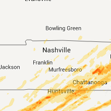
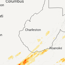
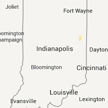
Hail Map for Wednesday, April 27, 2011

Number of Impacted Households on 4/27/2011
0
Impacted by 1" or Larger Hail
0
Impacted by 1.75" or Larger Hail
0
Impacted by 2.5" or Larger Hail
Square Miles of Populated Area Impacted on 4/27/2011
0
Impacted by 1" or Larger Hail
0
Impacted by 1.75" or Larger Hail
0
Impacted by 2.5" or Larger Hail


Cities Most Affected by Hail Storms of 4/27/2011
| Hail Size | Demographics of Zip Codes Affected | ||||||
|---|---|---|---|---|---|---|---|
| City | Count | Average | Largest | Pop Density | House Value | Income | Age |
| Cleveland, TN | 5 | 1.75 | 1.75 | 515 | $92k | $31.8k | 36.0 |
| Florence, MS | 4 | 2.13 | 2.50 | 127 | $91k | $40.8k | 37.4 |
| Knoxville, TN | 4 | 2.06 | 2.75 | 1085 | $78k | $31.0k | 34.2 |
| Pearisburg, VA | 3 | 2.17 | 2.50 | 56 | $76k | $37.6k | 42.1 |
| Bristol, TN | 2 | 2.75 | 2.75 | 313 | $80k | $30.9k | 43.1 |
| Bluff City, TN | 2 | 2.25 | 2.75 | 193 | $84k | $33.7k | 43.3 |
| Saltville, VA | 1 | 4.50 | 4.50 | 36 | $52k | $28.6k | 44.0 |
| Raleigh, MS | 2 | 2.25 | 2.75 | 18 | $49k | $28.1k | 41.6 |
| Batesville, MS | 1 | 4.00 | 4.00 | 57 | $65k | $29.4k | 35.3 |
| Hamilton, AL | 1 | 4.00 | 4.00 | 42 | $71k | $27.5k | 42.6 |
| Bristol, VA | 2 | 1.88 | 2.00 | 109 | $87k | $33.0k | 44.0 |
| White Pine, TN | 2 | 1.75 | 1.75 | 191 | $87k | $32.2k | 41.4 |
| Jasper, TN | 2 | 1.75 | 1.75 | 147 | $83k | $35.2k | 41.8 |
| Oil Trough, AR | 2 | 1.75 | 1.75 | 9 | $43k | $33.2k | 40.1 |
| Jackson, MO | 2 | 1.75 | 1.75 | 147 | $100k | $42.1k | 38.5 |
| Okolona, MS | 1 | 3.00 | 3.00 | 45 | $52k | $26.2k | 38.8 |
| Cordova, AL | 1 | 2.75 | 2.75 | 84 | $49k | $23.1k | 42.1 |
| Kingsport, TN | 1 | 2.75 | 2.75 | 640 | $83k | $30.4k | 43.5 |
| Pocahontas, AR | 1 | 2.75 | 2.75 | 44 | $57k | $29.2k | 41.5 |
| South Pittsburg, TN | 1 | 2.75 | 2.75 | 48 | $74k | $29.4k | 42.7 |
| Eggleston, VA | 1 | 2.50 | 2.50 | 21 | $70k | $23.8k | 48.3 |
| Wildwood, GA | 1 | 2.50 | 2.50 | 63 | $76k | $32.7k | 42.8 |
| Dry Fork, VA | 1 | 2.00 | 2.00 | 83 | $85k | $33.5k | 40.7 |
| Dandridge, TN | 1 | 2.00 | 2.00 | 183 | $96k | $34.6k | 44.1 |
| Mount Hope, AL | 1 | 1.75 | 1.75 | 23 | $72k | $36.8k | 38.6 |
| Poplar Bluff, MO | 1 | 1.75 | 1.75 | 111 | $62k | $27.4k | 39.9 |
| Athens, AL | 1 | 1.75 | 1.75 | 230 | $78k | $31.4k | 38.6 |
| Farmville, VA | 1 | 1.75 | 1.75 | 69 | $94k | $30.5k | 33.8 |
| Rome, GA | 1 | 1.75 | 1.75 | 242 | $87k | $35.5k | 35.9 |
| Harvest, AL | 1 | 1.75 | 1.75 | 563 | $114k | $55.0k | 36.9 |
| Clarksville, AR | 1 | 1.75 | 1.75 | 113 | $63k | $28.4k | 34.5 |
| Calhoun City, MS | 1 | 1.75 | 1.75 | 17 | $46k | $24.8k | 40.1 |
| Friendsville, TN | 1 | 1.75 | 1.75 | 229 | $118k | $43.4k | 43.6 |
| Loudon, TN | 1 | 1.75 | 1.75 | 223 | $117k | $42.2k | 53.3 |
| Marietta, SC | 1 | 1.75 | 1.75 | 77 | $82k | $35.8k | 41.3 |
| Hackleburg, AL | 1 | 1.75 | 1.75 | 33 | $56k | $26.5k | 43.3 |
| Madison, AL | 1 | 1.75 | 1.75 | 1233 | $115k | $57.0k | 36.7 |
| Clayton, GA | 1 | 1.75 | 1.75 | 38 | $99k | $34.6k | 44.2 |
| Powhatan, VA | 1 | 1.75 | 1.75 | 104 | $128k | $51.9k | 41.3 |
| Ider, AL | 1 | 1.75 | 1.75 | 90 | $64k | $28.3k | 41.1 |
| Newport, TN | 1 | 1.75 | 1.75 | 188 | $74k | $25.8k | 41.5 |
| Talking Rock, GA | 1 | 1.75 | 1.75 | 71 | $89k | $35.5k | 39.7 |
| Port Gibson, MS | 1 | 1.75 | 1.75 | 24 | $49k | $23.6k | 38.1 |
| Terry, MS | 1 | 1.75 | 1.75 | 92 | $112k | $46.4k | 43.6 |
| Augusta, GA | 1 | 1.75 | 1.75 | 2099 | $100k | $54.2k | 37.8 |
| Fulton, MS | 1 | 1.75 | 1.75 | 54 | $61k | $30.8k | 38.2 |
| Lenoir, NC | 1 | 1.75 | 1.75 | 139 | $82k | $33.2k | 42.1 |
| Toney, AL | 1 | 1.75 | 1.75 | 178 | $85k | $38.9k | 35.5 |
| Charleston, TN | 1 | 1.75 | 1.75 | 94 | $111k | $42.8k | 41.2 |
| Cleveland, AR | 1 | 1.75 | 1.75 | 14 | $58k | $32.3k | 40.1 |
| Lagrange, GA | 1 | 1.75 | 1.75 | 215 | $100k | $40.5k | 36.7 |
| Mount Judea, AR | 1 | 1.75 | 1.75 | 5 | $37k | $19.8k | 48.5 |
| Cumberland, VA | 1 | 1.75 | 1.75 | 32 | $80k | $33.7k | 40.8 |
| Axton, VA | 1 | 1.75 | 1.75 | 59 | $75k | $36.2k | 41.9 |
| Lenoir City, TN | 1 | 1.75 | 1.75 | 333 | $76k | $33.2k | 38.5 |
| Oxford, MS | 1 | 1.75 | 1.75 | 105 | $109k | $27.8k | 29.2 |
| Fork Union, VA | 1 | 1.75 | 1.75 | 39 | $88k | $34.7k | 41.9 |
| Chilhowie, VA | 1 | 1.75 | 1.75 | 70 | $76k | $30.5k | 42.5 |
| Memphis, TN | 1 | 1.75 | 1.75 | 3596 | $39k | $10.7k | 26.6 |
| Ooltewah, TN | 1 | 1.75 | 1.75 | 438 | $128k | $52.4k | 39.6 |
| Hartman, AR | 1 | 1.75 | 1.75 | 37 | $46k | $28.3k | 38.7 |
| Vonore, TN | 1 | 1.75 | 1.75 | 32 | $95k | $36.7k | 50.0 |
| Chattanooga, TN | 1 | 1.75 | 1.75 | 1087 | $62k | $23.3k | 35.3 |
Hail and Wind Damage Spotted on 4/27/2011
Filter by Report Type:Hail ReportsWind Reports
States Impacted
Alabama, Kentucky, Tennessee, Georgia, Ohio, Arkansas, Mississippi, North Carolina, Missouri, Louisiana, Virginia, New Jersey, Illinois, South Carolina, Pennsylvania, New York, West Virginia, Maryland, FloridaAlabama
| Local Time | Report Details |
|---|---|
| 12:00 PM UTC | Numerous trees and powerlines down in and around ashland. tree on house in the shireys mill community in ashlan in clay county AL, 50.8 miles NNW of Auburn, AL |
| 12:00 PM UTC | Large trees down on vehicles. time estimated from radar. possible tornad in jackson county AL, 55.6 miles SW of Chattanooga, TN |
| 12:02 PM UTC | Trees down in teh tates chapel communit in cherokee county AL, 62.9 miles SSW of Chattanooga, TN |
| 12:05 PM UTC | A large tree fell on a home along highway 411 north. one person was trapped. numerous trees down around the are in cherokee county AL, 65.1 miles SSW of Chattanooga, TN |
| 12:05 PM UTC | A large tree fell on a home along highway 411 north. on person was trappe in cherokee county AL, 65.1 miles SSW of Chattanooga, TN |
| 7:05 AM CDT | Trees down blocking hwy in cherokee county AL, 70.1 miles SSW of Chattanooga, TN |
| 12:05 PM UTC | Numerous trees down between section and macedonia along highway 35. time estimated from rada in jackson county AL, 50.3 miles SW of Chattanooga, TN |
| 12:05 PM UTC | Some structure damage reported in ballplay. one person trappe in etowah county AL, 66.5 miles ENE of Birmingham, AL |
| 12:06 PM UTC | Significant structural damage to new bethel church on hwy 411 in cherokee county AL, 66.5 miles SSW of Chattanooga, TN |
| 12:36 PM UTC | Half Dollar sized hail reported near Phil Campbell, AL, 33.2 miles S of Florence, AL, up to half dollar size hail was reported in the bear creek area. |
| 8:28 AM CDT | Golf Ball sized hail reported near Hackleburg, AL, 37.6 miles SSW of Florence, AL |
| 1:36 PM UTC | Ping Pong Ball sized hail reported near Phil Campbell, AL, 32.6 miles S of Florence, AL, ping pong size hail was reported. |
| 2:30 PM UTC | Quarter sized hail reported near , , 38.6 miles E of Florence, AL, one inch hail was reported. |
| 2:46 PM UTC | Quarter sized hail reported near Harvest, AL, 52.8 miles E of Florence, AL, quarter size hail was reported. |
| 2:50 PM UTC | Golf Ball sized hail reported near Toney, AL, 55.1 miles E of Florence, AL, golf ball size hail was reported. |
| 3:05 PM UTC | Quarter sized hail reported near Huntsville, AL, 61.9 miles E of Florence, AL, quarter size hail was reported on pulaski pike. |
| 3:43 PM UTC | Trees and powerlines down on frankfort rd in colbert county AL, 5.2 miles SSW of Florence, AL |
| 3:45 PM UTC | Winds were blowing flag poles near the ground and branchese down. winds were estimated over 60 mp in colbert county AL, 4.4 miles SSW of Florence, AL |
| 3:47 PM UTC | A wind gust to 60 mph was observed at the msl aso in colbert county AL, 4.2 miles S of Florence, AL |
| 3:47 PM UTC | Tree on house on waterloo road in franklin county AL, 20.5 miles SSW of Florence, AL |
| 3:48 PM UTC | An outbuilding was destroye in colbert county AL, 4.6 miles SSE of Florence, AL |
| 10:53 AM CDT | Nickel size hail was reporte in franklin county AL, 20.3 miles S of Florence, AL |
| 4:10 PM UTC | A large tree was blown down over highway 72 at the entrance of joe wheeler state park. wind gust to 69 mph was measure in lauderdale county AL, 20.3 miles E of Florence, AL |
| 4:11 PM UTC | Big trees uprooted on oak street in leighton in colbert county AL, 10.8 miles SE of Florence, AL |
| 4:14 PM UTC | Gust was measured at the courtland awos at 53 knots in lawrence county AL, 22.7 miles ESE of Florence, AL |
| 4:18 PM UTC | Trees and power lines down on highway 101...highway 33...and batts road in limestone county AL, 31.8 miles E of Florence, AL |
| 4:25 PM UTC | Trees down on highway 101 in lawrence county AL, 22.4 miles SE of Florence, AL |
| 4:29 PM UTC | Large trees were blown down. some were snappe in limestone county AL, 50.4 miles E of Florence, AL |
| 4:40 PM UTC | Powerlines down near rainbow and neil roa in madison county AL, 61.9 miles E of Florence, AL |
| 4:40 PM UTC | Large trees blown dow in limestone county AL, 48.1 miles E of Florence, AL |
| 4:40 PM UTC | A tree was reported down on a hous in morgan county AL, 57.4 miles ESE of Florence, AL |
| 11:43 AM CDT | Barn ripped off near the limestone county jail...and numerous trees reported down on sanderson road and capshaw in limestone county AL, 31.7 miles E of Florence, AL |
| 4:49 PM UTC | A wind gust of 59 mph was observe in madison county AL, 61.9 miles E of Florence, AL |
| 4:53 PM UTC | A tree was blown down on a house. possible tornado damag in madison county AL, 61.9 miles E of Florence, AL |
| 4:58 PM UTC | Trees and power lines down near mount sharon and highway 23 in madison county AL, 61.9 miles E of Florence, AL |
| 4:58 PM UTC | Trees blown on slaughter and eastview roa in madison county AL, 61.9 miles E of Florence, AL |
| 5:03 PM UTC | A large tree was blown down on a mobile hom in limestone county AL, 48.1 miles E of Florence, AL |
| 5:03 PM UTC | Damage reported around buckhorn high school. possible tornado damag in madison county AL, 65.6 miles W of Chattanooga, TN |
| 5:18 PM UTC | All four lanes of highway 72 closed due to debri in limestone county AL, 48.2 miles E of Florence, AL |
| 5:20 PM UTC | Collapsed building on hayden street in morgan county AL, 41.7 miles ESE of Florence, AL |
| 5:30 PM UTC | Two trees were blown down near the intersection of constatt and weatherl in madison county AL, 64.9 miles E of Florence, AL |
| 5:30 PM UTC | Roof was blown off a house on mount zion road near monrovia middle schoo in madison county AL, 54.9 miles E of Florence, AL |
| 5:40 PM UTC | Building collapsed near the intersection of highway 53 and von braun driv in madison county AL, 57.2 miles E of Florence, AL |
| 5:53 PM UTC | Debris and trees blocking the road. possible tornado damag in madison county AL, 64.7 miles WSW of Chattanooga, TN |
| 6:00 PM UTC | Half Dollar sized hail reported near Bridgeport, AL, 28.3 miles WSW of Chattanooga, TN, hail up to half dollar size fell. |
| 6:00 PM UTC | Large trees blown down and flashing blown off of part of a hous in jackson county AL, 28.3 miles WSW of Chattanooga, TN |
| 6:30 PM UTC | Aluminum roofing pieces from a covered walkway twisted around trees at creekside elementary. some stuctural damage may have occurred. possible tornado damag in madison county AL, 52.1 miles E of Florence, AL |
| 6:35 PM UTC | A tree was blown down onto a house on plummer roa in madison county AL, 56.6 miles E of Florence, AL |
| 6:43 PM UTC | Roof damage reported at indian creek chruc in madison county AL, 56.6 miles E of Florence, AL |
| 7:00 PM UTC | Homes back porch and 1/4 of rear roof shingles blown off. 32-foot travel trailer overturned. possible tornad in madison county AL, 52.8 miles E of Florence, AL |
| 7:36 PM UTC | A tree was blown down on a mobile hom in colbert county AL, 2.8 miles S of Florence, AL |
| 8:25 PM UTC | Roofs blown off houses and trees down. location was hollywood and veterans driv in lauderdale county AL, 0.3 miles W of Florence, AL |
| 8:44 PM UTC | Quarter sized hail reported near Mt Hope, AL, 26 miles SSE of Florence, AL, measured by spotter. |
| 8:45 PM UTC | Golf Ball sized hail reported near Mt Hope, AL, 26 miles SSE of Florence, AL |
| 9:47 PM UTC | Storm damage reported in madison county AL, 56.2 miles E of Florence, AL |
| 4:48 PM CDT | Baseball sized hail reported near Cordova, AL, 27.4 miles NW of Birmingham, AL |
| 5:10 PM CDT | Golf Ball sized hail reported near Athens, AL, 40.1 miles E of Florence, AL, hail sw side of athens. |
| 10:28 PM UTC | Golf Ball sized hail reported near Harvest, AL, 52.6 miles E of Florence, AL |
| 6:42 PM CDT | Grapefruit sized hail reported near Hamilton, AL, 48.7 miles SSW of Florence, AL |
| 11:44 PM UTC | Golf Ball sized hail reported near Ider, AL, 31.5 miles SW of Chattanooga, TN |
| 11:45 PM UTC | Storm damage reported in limestone county AL, 40.4 miles E of Florence, AL |
| 12:00 AM UTC | Quarter sized hail reported near Pelham, AL, 15.2 miles S of Birmingham, AL, quarter size hail reported at the intersection of industrial road and highway 31. |
| 12:14 AM UTC | Quarter sized hail reported near Gadsden, AL, 57.2 miles NE of Birmingham, AL, quarter size hail reported over the city of gadsden. |
| 12:17 AM UTC | Golf Ball sized hail reported near Madison, AL, 50.5 miles E of Florence, AL |
| 7:58 PM CDT | Quarter sized hail reported near Addison, AL, 50.9 miles SE of Florence, AL, measured by emergency manager. |
| 2:42 AM UTC | Trees were blown down. at least two mobile homes destroyed. at least one roof damaged. near the intersection of cr-24 and cr-59. possible tornad in chilton county AL, 55 miles SSE of Birmingham, AL |
Kentucky
| Local Time | Report Details |
|---|---|
| 12:03 PM UTC | Two barns down. numerous trees and powerlines down. two trees down on houses. numerous sheds damaged. all along judio road near the town of judi in cumberland county KY, 81.2 miles ENE of Nashville, TN |
| 12:23 PM UTC | A few trees down in clinton county KY, 84.6 miles NW of Knoxville, TN |
| 12:31 PM UTC | One powerline across midway pik in woodford county KY, 47.8 miles WNW of Irvine, KY |
| 12:35 PM UTC | One tree down on a power line on dixie hwy. time estimate in grant county KY, 26.5 miles S of Cincinnati, OH |
| 12:40 PM UTC | Trees down on highway 67 in wayne county KY, 78.5 miles SW of Irvine, KY |
| 12:40 PM UTC | Trees down on highway 67 in wayne county KY, 81.2 miles SW of Irvine, KY |
| 12:41 PM UTC | One tree down in casey county KY, 66.1 miles WSW of Irvine, KY |
| 12:45 PM UTC | Trees down on hollow roa in wayne county KY, 78.1 miles SW of Irvine, KY |
| 12:47 PM UTC | Tree down on highway 200 at flat spring in wayne county KY, 76.7 miles SW of Irvine, KY |
| 12:47 PM UTC | Tree down on house on highway 239 in wayne county KY, 71.2 miles SW of Irvine, KY |
| 12:48 PM UTC | Storm damage reported in grant county KY, 32.3 miles S of Cincinnati, OH |
| 1:00 PM UTC | One tree down on shelby st. time estimate in pendleton county KY, 31.6 miles SSE of Cincinnati, OH |
| 1:00 PM UTC | One tree down at river rd and army reserve rd. time estimate in campbell county KY, 4.4 miles SE of Cincinnati, OH |
| 1:02 PM UTC | One tree down on sr 609. time estimate in pendleton county KY, 27.8 miles SSE of Cincinnati, OH |
| 1:04 PM UTC | County-wide trees down. roof blown off of a traile in lincoln county KY, 39.4 miles WSW of Irvine, KY |
| 1:06 PM UTC | Tree down along highway 124 in pulaski county KY, 51.2 miles SW of Irvine, KY |
| 1:13 PM UTC | Tree down across beulah heights road. time estimated off of rada in mccreary county KY, 64.7 miles NNW of Knoxville, TN |
| 1:13 PM UTC | Road sign damaged near exit 104 on i-75 and penny sized hai in fayette county KY, 28.5 miles NW of Irvine, KY |
| 1:20 PM UTC | Multiple mobile homes damaged and trees down with power lines dow in lincoln county KY, 37.6 miles SW of Irvine, KY |
| 1:26 PM UTC | Tree down on highway 92 between mile marker 9 and 1 in mccreary county KY, 66 miles NW of Knoxville, TN |
| 1:30 PM UTC | Tree blocking road and knocking down power lines on peach tree lane near brodhead in rockcastle county KY, 32 miles SW of Irvine, KY |
| 1:34 PM UTC | Roof blown off barn. board put through the window of a truck. top snapped out of a 20 inch diameter tre in mccreary county KY, 53.9 miles NNW of Knoxville, TN |
| 1:34 PM UTC | Tree blocking road on scaffold cane branch r in rockcastle county KY, 24.3 miles SW of Irvine, KY |
| 1:35 PM UTC | Trees were downed or snapped along gabbard road. one was blown on to a mobile hom in garrard county KY, 26.6 miles WSW of Irvine, KY |
| 1:36 PM UTC | Damage to a mobile home and some 3 to 4 inch diameter tree limbs down on highway 9 in mccreary county KY, 56.1 miles NNW of Knoxville, TN |
| 1:40 PM UTC | Tree down across beulah heights road. time estimated off of rada in mccreary county KY, 64.7 miles NNW of Knoxville, TN |
| 1:45 PM UTC | Tree blocking roa in jackson county KY, 16.4 miles SSW of Irvine, KY |
| 1:45 PM UTC | Tobacco barn damage along highway 627 in clark county KY, 20.4 miles NW of Irvine, KY |
| 1:50 PM UTC | Tree down on campbell branch roa in estill county KY, 6.9 miles WSW of Irvine, KY |
| 1:50 PM UTC | Tree down over highway 90 near mills old riding statio in whitley county KY, 62 miles SSW of Irvine, KY |
| 1:50 PM UTC | Tree down over highwy 90 near mills old riding statio in whitley county KY, 62 miles SSW of Irvine, KY |
| 2:00 PM UTC | Trees down on watson ridge road...marble yard road...campbell branch road and cobb hill roa in estill county KY, 3.1 miles ENE of Irvine, KY |
| 2:12 PM UTC | Trees on power lines along highway 1006 and 36 in laurel county KY, 41.1 miles S of Irvine, KY |
| 2:16 PM UTC | Trees down and roof blown off of barn on mcwhorter roa in laurel county KY, 38.2 miles S of Irvine, KY |
| 2:25 PM UTC | 2 trees blocking roa in jackson county KY, 18.7 miles S of Irvine, KY |
| 10:29 PM UTC | Quarter sized hail reported near Coldiron, KY, 65.4 miles NNE of Knoxville, TN |
| 10:43 PM UTC | Limbs...3 to 4 inch in diameter...blown dow in whitley county KY, 51 miles NNW of Knoxville, TN |
| 11:42 PM UTC | Quarter sized hail reported near Baxter, KY, 65.1 miles WNW of Bristol, TN, quarter size hail was reported by law enforecement. |
| 11:45 PM UTC | Quarter sized hail reported near Harlan, KY, 63.3 miles WNW of Bristol, TN |
| 11:46 PM UTC | Wind gusts estimated up to 60 mp in harlan county KY, 65.1 miles WNW of Bristol, TN |
| 11:49 PM UTC | A trained spotter reported that several 3-5 inch diameter limbs were blown from trees in evarts. some shingles were also blown off of his home while the storm passed. t in harlan county KY, 57.4 miles WNW of Bristol, TN |
| 11:49 PM UTC | Quarter sized hail reported near Evarts, KY, 57.4 miles WNW of Bristol, TN, quarter size hail was reported in evarts. |
| 11:50 PM UTC | Quarter sized hail reported near Harlan, KY, 63.3 miles WNW of Bristol, TN |
| 11:55 PM UTC | Tree across roa in harlan county KY, 63.3 miles SSE of Irvine, KY |
| 11:55 PM UTC | Mudslide with trees blocking ky3 in harlan county KY, 57.4 miles WNW of Bristol, TN |
| 12:48 AM UTC | A tree was blown down into the roadwa in pike county KY, 48.2 miles NNW of Bristol, TN |
| 1:00 AM UTC | Tree blown down into the road on ky highway 29 in pike county KY, 58.4 miles SW of Charleston, WV |
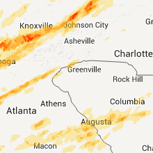
Tennessee
| Local Time | Report Details |
|---|---|
| 12:08 PM UTC | Multiple trees blown down on hwy 8 in overton county TN, 81.8 miles WNW of Knoxville, TN |
| 12:15 PM UTC | Trees blown down along rock road and new hope road off of highway 55 in summitville are in coffee county TN, 51.4 miles NW of Chattanooga, TN |
| 12:30 PM UTC | *** 1 fatal *** woman was struck in the head by a fallen tree limb and died 24 hours later in williamson county TN, 16.8 miles SSW of Nashville, TN |
| 12:32 PM UTC | Trees down on power lines near 1674 rocks road in summitvill in coffee county TN, 51.8 miles NW of Chattanooga, TN |
| 12:45 PM UTC | Couple trees down on highway 127 reported by dispat in bledsoe county TN, 39.3 miles N of Chattanooga, TN |
| 12:45 PM UTC | Several trees down on highway 127 in cumberland county TN, 62.7 miles W of Knoxville, TN |
| 12:50 PM UTC | Several trees snapped off or uprooted and tw in fentress county TN, 66.2 miles WNW of Knoxville, TN |
| 1:08 PM UTC | Multiple trees blown down...one on a house trapping a woman inside. one quarter of people in eastern fentress county are still without powe in fentress county TN, 59.5 miles WNW of Knoxville, TN |
| 1:35 PM UTC | Numerous trees and power lines down in cleveland and northeast part of the count in bradley county TN, 26.5 miles ENE of Chattanooga, TN |
| 2:00 PM UTC | One tree down in walland and one down in seymou in blount county TN, 16.9 miles SSE of Knoxville, TN |
| 10:23 AM CDT | Quarter sized hail reported near Memphis, TN, 1.4 miles S of Memphis, TN, quarter size hail at jackson and pope street |
| 10:24 AM CDT | Golf Ball sized hail reported near Memphis, TN, 1.4 miles S of Memphis, TN, hail cracked a windshield in downtown memphis area |
| 3:30 PM UTC | Quarter sized hail reported near Memphis, TN, 11.2 miles ENE of Memphis, TN |
| 3:40 PM UTC | Quarter sized hail reported near Bartlett, TN, 12.8 miles ENE of Memphis, TN, penny to quarter size hail covered the ground. |
| 4:08 PM UTC | New lake road near jorgensen lane...70 mph winds...quarter-size hail...3 trees lifted out of the ground in marshall county TN, 52.4 miles S of Nashville, TN |
| 5:15 PM UTC | Wall cloud reporte in franklin county TN, 46.4 miles WNW of Chattanooga, TN |
| 5:40 PM UTC | Quarter sized hail reported near Manchester, TN, 52.4 miles NW of Chattanooga, TN, quarter sized hail reported in the city of manchester. |
| 6:06 PM UTC | Trees and power lines blown down in the coalmont... gruetli-laager and palmer area in grundy county TN, 29.1 miles NW of Chattanooga, TN |
| 6:06 PM UTC | Quarter sized hail reported near Palmer, TN, 26.2 miles NW of Chattanooga, TN |
| 6:20 PM UTC | Trees down on hwy 150 blocking the roa in marion county TN, 25.1 miles WNW of Chattanooga, TN |
| 6:25 PM UTC | Golf Ball sized hail reported near Jasper, TN, 17.1 miles W of Chattanooga, TN |
| 6:40 PM UTC | Numerous trees dow in sequatchie county TN, 22.8 miles NNW of Chattanooga, TN |
| 2:44 PM EDT | Quarter sized hail reported near Chattanooga, TN, 2.4 miles ENE of Chattanooga, TN |
| 3:20 PM EDT | Golf Ball sized hail reported near Cleveland, TN, 26.5 miles ENE of Chattanooga, TN |
| 3:29 PM EDT | Golf Ball sized hail reported near Calhoun, TN, 36.2 miles ENE of Chattanooga, TN |
| 7:36 PM UTC | Damage to apartments on crown colony driv in bradley county TN, 26.5 miles ENE of Chattanooga, TN |
| 7:36 PM UTC | Roof blown off home on overbrook circl in bradley county TN, 26.5 miles ENE of Chattanooga, TN |
| 7:36 PM UTC | Trees down on homes near intersection of greenwood and oakcres in bradley county TN, 26.5 miles ENE of Chattanooga, TN |
| 8:35 PM UTC | Trees and power lines down on hwy 16 in mcminn county TN, 49.1 miles SW of Knoxville, TN |
| 9:30 PM UTC | Trees dow in morgan county TN, 46.1 miles WNW of Knoxville, TN |
| 9:45 PM UTC | Trees dow in scott county TN, 49.7 miles NW of Knoxville, TN |
| 9:45 PM UTC | Trees blown down on power lines near lake tans in cumberland county TN, 60 miles N of Chattanooga, TN |
| 10:00 PM UTC | Trees down and a power pole spli in campbell county TN, 44.3 miles NNW of Knoxville, TN |
| 10:03 PM UTC | Quarter sized hail reported near Jamestown, TN, 63.4 miles WNW of Knoxville, TN, quarter size of hail reported |
| 10:04 PM UTC | Emergency managers office reports multiple trees in cumberland county TN, 59 miles NNE of Chattanooga, TN |
| 10:15 PM UTC | Golf Ball sized hail reported near Chattanooga, TN, 3.2 miles ENE of Chattanooga, TN, hail occurring in the missionary ridge area. |
| 10:15 PM UTC | Several trees down. 1 tree down on a home on ailshie roa in hamblen county TN, 38.8 miles ENE of Knoxville, TN |
| 6:19 PM EDT | Golf Ball sized hail reported near Chattanooga, TN, 12.5 miles E of Chattanooga, TN, hail at interstate 75 near ooltewah |
| 10:20 PM UTC | Hardware store destroyed on hwy 57...trucked flipped over. spotter saw funnel cloud...possible tornado...however funnel became rain wrapped before moving over locatio in hardin county TN, 37.8 miles WNW of Florence, AL |
| 5:21 PM CDT | Baseball sized hail reported near South Pittsburg, TN, 23.9 miles W of Chattanooga, TN, occurring on battle creek road |
| 10:24 PM UTC | Numerous trees and power lines down county wid in scott county TN, 49.7 miles NW of Knoxville, TN |
| 6:30 PM EDT | Quarter sized hail reported near Greeneville, TN, 38.4 miles WSW of Bristol, TN |
| 6:30 PM EDT | Golf Ball sized hail reported near Cleveland, TN, 26.5 miles ENE of Chattanooga, TN |
| 10:30 PM UTC | Golf Ball sized hail reported near Jasper, TN, 18.2 miles W of Chattanooga, TN |
| 10:32 PM UTC | Numerous trees down in the midway communit in marion county TN, 23 miles W of Chattanooga, TN |
| 6:38 PM EDT | Golf Ball sized hail reported near Cleveland, TN, 26.5 miles ENE of Chattanooga, TN, hail occurring 1 mile south of exit 25 on interstate 75. |
| 10:40 PM UTC | Trees down on old parkersville roa in bradley county TN, 26.5 miles ENE of Chattanooga, TN |
| 10:50 PM UTC | Trees blown down in several areas near tracy city. one tree fell on a hous in grundy county TN, 29 miles WNW of Chattanooga, TN |
| 10:54 PM UTC | Roof blown off home and several trees down in the cog hill communit in mcminn county TN, 43.8 miles ENE of Chattanooga, TN |
| 10:55 PM UTC | Trees blown down and power lines dow in coffee county TN, 52 miles WNW of Chattanooga, TN |
| 11:00 PM UTC | Trees and power lines down near the athens rd and pinhook rd intersectio in polk county TN, 37.5 miles ENE of Chattanooga, TN |
| 11:00 PM UTC | Quarter sized hail reported near Church Hill, TN, 27.5 miles W of Bristol, TN |
| 11:00 PM UTC | Quarter sized hail reported near Elora, TN, 59.6 miles W of Chattanooga, TN |
| 7:00 PM EDT | Half Dollar sized hail reported near Cleveland, TN, 26.5 miles ENE of Chattanooga, TN |
| 11:22 PM UTC | Quarter sized hail reported near Spring City, TN, 51.1 miles NNE of Chattanooga, TN |
| 11:25 PM UTC | Quarter sized hail reported near Dunlap, TN, 22.1 miles NNW of Chattanooga, TN |
| 11:30 PM UTC | Quarter sized hail reported near Greenback, TN, 20 miles SSW of Knoxville, TN |
| 7:43 PM EDT | Golf Ball sized hail reported near Loudon, TN, 29 miles WSW of Knoxville, TN |
| 11:46 PM UTC | Quarter sized hail reported near Louisville, TN, 11.2 miles SSW of Knoxville, TN, reported at mcghee tyson airport. |
| 11:53 PM UTC | Trees blown in the hillsboro communit in coffee county TN, 44.7 miles WNW of Chattanooga, TN |
| 12:00 AM UTC | Carpenters grade road and bert garner ln in blount county TN, 22.1 miles SSW of Knoxville, TN |
| 12:00 AM UTC | Trees down near intersection of carpenters grade road and bert garner l in blount county TN, 22.1 miles SSW of Knoxville, TN |
| 8:00 PM EDT | Golf Ball sized hail reported near Lenoir City, TN, 22.5 miles WSW of Knoxville, TN |
| 8:04 PM EDT | Quarter sized hail reported near Farragut, TN, 15.8 miles WSW of Knoxville, TN |
| 8:05 PM EDT | Hen Egg sized hail reported near Knoxville, TN, 3.4 miles WNW of Knoxville, TN |
| 12:10 AM UTC | Quarter sized hail reported near Dandridge, TN, 28.4 miles E of Knoxville, TN |
| 8:10 PM EDT | Golf Ball sized hail reported near Friendsville, TN, 18.1 miles SW of Knoxville, TN |
| 8:10 PM EDT | Golf Ball sized hail reported near Knoxville, TN, 1.8 miles WNW of Knoxville, TN |
| 8:15 PM EDT | Baseball sized hail reported near Knoxville, TN, 0.7 miles S of Knoxville, TN, large hail damaged vehicles in the area. |
| 8:19 PM EDT | Golf Ball sized hail reported near Knoxville, TN, 1.8 miles WNW of Knoxville, TN, occurring on the university of tennessee campus. |
| 12:19 AM UTC | Occurring on the university of tennessee campu in knox county TN, 1.8 miles WNW of Knoxville, TN |
| 12:20 AM UTC | Moderate roof damage to homes in the louisville are in blount county TN, 12.8 miles SSW of Knoxville, TN |
| 12:28 AM UTC | Golf Ball sized hail reported near White Pine, TN, 36.1 miles ENE of Knoxville, TN |
| 12:30 AM UTC | Golf Ball sized hail reported near White Pine, TN, 36.1 miles ENE of Knoxville, TN, occurred on leadvale rd. |
| 12:30 AM UTC | Several reports of trees blown down. one tree on a hous in warren county TN, 51.7 miles NNW of Chattanooga, TN |
| 8:32 PM EDT | Half Dollar sized hail reported near Knoxville, TN, 1.8 miles WNW of Knoxville, TN, occurring at intersection of central and woodland east of interstate 275 and just north of interstate 40. |
| 8:38 PM EDT | Quarter sized hail reported near Farragut, TN, 15.8 miles WSW of Knoxville, TN |
| 12:45 AM UTC | Numerous trees dow in greene county TN, 50.9 miles ENE of Knoxville, TN |
| 12:45 AM UTC | Quarter sized hail reported near Church Hill, TN, 29.5 miles WSW of Bristol, TN |
| 8:48 PM EDT | Golf Ball sized hail reported near Cleveland, TN, 28.7 miles ENE of Chattanooga, TN |
| 12:48 AM UTC | Hen Egg sized hail reported near Dandridge, TN, 25.9 miles E of Knoxville, TN |
| 12:53 AM UTC | Quarter sized hail reported near Luttrell, TN, 20 miles NNE of Knoxville, TN |
| 8:55 PM EDT | Golf Ball sized hail reported near Newport, TN, 42.4 miles ENE of Knoxville, TN |
| 12:55 AM UTC | Golf Ball sized hail reported near Cleveland, TN, 28.2 miles ENE of Chattanooga, TN |
| 1:15 AM UTC | Roof blown off buildin in sequatchie county TN, 22.8 miles NNW of Chattanooga, TN |
| 1:15 AM UTC | Quarter sized hail reported near Athens, TN, 48.8 miles NE of Chattanooga, TN, occurring on south jackson street. |
| 1:25 AM UTC | Several trees and powerlines down in and around sullivan gardens with no indication of a tornado. reported by nws storm survey tea in sullivan county TN, 21.4 miles WSW of Bristol, TN |
| 9:25 PM EDT | Baseball sized hail reported near Kingsport, TN, 21.4 miles WSW of Bristol, TN, baseball sized hail fellinand around sullivan gardens with no indication of a tornado. reported by nws storm survey team. |
| 9:30 PM EDT | Golf Ball sized hail reported near Vonore, TN, 30.3 miles SW of Knoxville, TN |
| 2:00 AM UTC | Quarter sized hail reported near Sevierville, TN, 21.7 miles ESE of Knoxville, TN |
| 2:05 AM UTC | Couple trees dow in bradley county TN, 26.5 miles ENE of Chattanooga, TN |
| 10:06 PM EDT | Baseball sized hail reported near Bluff City, TN, 7.4 miles SSW of Bristol, TN |
| 2:08 AM UTC | Numerous trees down at douglas campgroun in jefferson county TN, 28.4 miles E of Knoxville, TN |
| 2:08 AM UTC | Numerous trees down on road and damage to a hom in rhea county TN, 51.1 miles NNE of Chattanooga, TN |
| 10:13 PM EDT | Half Dollar sized hail reported near Bristol, TN, 1.9 miles SE of Bristol, TN |
| 2:25 AM UTC | Half Dollar sized hail reported near Johnson City, TN, 19.1 miles SW of Bristol, TN |
| 2:30 AM UTC | Numerous trees dow in cocke county TN, 50 miles E of Knoxville, TN |
| 2:30 AM UTC | Numerous trees down and damage to cocke county high schoo in cocke county TN, 41 miles E of Knoxville, TN |
| 10:39 PM EDT | Golf Ball sized hail reported near Bluff City, TN, 5.9 miles SSW of Bristol, TN |
| 10:58 PM EDT | Baseball sized hail reported near Bristol, TN, 11 miles SE of Bristol, TN |
| 3:00 AM UTC | Half Dollar sized hail reported near Benton, TN, 38.5 miles ENE of Chattanooga, TN, quarter to half dollar size hail. |
| 11:06 PM EDT | Baseball sized hail reported near Bristol, TN, 1.9 miles SE of Bristol, TN |
| 3:20 AM UTC | Tree down on traile in union county TN, 26.9 miles NNE of Knoxville, TN |
| 11:45 PM EDT | Half Dollar sized hail reported near Townsend, TN, 21.6 miles SSE of Knoxville, TN |
| 5:00 AM UTC | Trees dow in carter county TN, 21.7 miles S of Bristol, TN |
| 5:10 AM UTC | Trees dow in greene county TN, 40.9 miles SW of Bristol, TN |
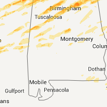
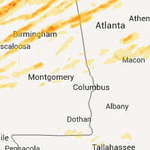
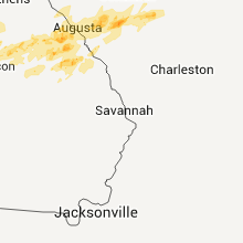
Georgia
| Local Time | Report Details |
|---|---|
| 12:17 PM UTC | Floyd county ema relayed a report of widespread tree damage near cave spring in floyd count in floyd county GA, 59.9 miles WNW of Atlanta, GA |
| 12:27 PM UTC | Haralson county 911 relayed a report of trees down countywid in haralson county GA, 46.1 miles W of Atlanta, GA |
| 8:27 AM EDT | Polk county 911 relayed a report of widespread tree damage across the count in polk county GA, 52.6 miles WNW of Atlanta, GA |
| 12:27 PM UTC | *** 4 inj *** floyd county emergency manager reported over 300 downed in floyd county GA, 54.6 miles S of Chattanooga, TN |
| 12:27 PM UTC | Floyd county ema relayed a report of trees down on the west side of rom in floyd county GA, 54.6 miles S of Chattanooga, TN |
| 12:27 PM UTC | Floyd county ema relayed a report of trees down on the west side of rome. tree damage was also reported at berry college...and the grand woods subdivisio in floyd county GA, 54.6 miles S of Chattanooga, TN |
| 12:30 PM UTC | The public relayed a report of a tree on a house and car in tallapoos in haralson county GA, 51.8 miles W of Atlanta, GA |
| 12:36 PM UTC | Dade county ema relayed a report of widespread tree damage in dade county in dade county GA, 16.7 miles SW of Chattanooga, TN |
| 12:41 PM UTC | Walker county 911 relayed a report of several trees down in shuttles mil in walker county GA, 30.3 miles SSE of Chattanooga, TN |
| 12:41 PM UTC | Dade county ema relayed a report of possible tornado damage in trenton. dade elementary school had part of its roof lifted u in dade county GA, 16.6 miles SW of Chattanooga, TN |
| 12:48 PM UTC | Catoosa county 911 relayed a report of numerous trees down in lakeview. a tree was reported on a house in that are in catoosa county GA, 5.4 miles SSE of Chattanooga, TN |
| 12:59 PM UTC | Roof off a building in downtown calhou in gordon county GA, 42.9 miles SSE of Chattanooga, TN |
| 12:59 PM UTC | Whitfield 911 relayed a report of two trees dow in whitfield county GA, 27.1 miles SE of Chattanooga, TN |
| 12:59 PM UTC | Whitfield county ema relayed a report of several trees down nw of dalto in whitfield county GA, 24.9 miles SE of Chattanooga, TN |
| 1:00 PM UTC | Public relayed a report of two trees dow in gordon county GA, 38.4 miles SSE of Chattanooga, TN |
| 1:08 PM UTC | Murray county 911 relayed a report of widespread tree damage and power lines down county wid in murray county GA, 36.1 miles ESE of Chattanooga, TN |
| 6:30 PM UTC | Dade county emergency management reported over 50 downed trees and powerlines along highway 299 in the northern section of the count in dade county GA, 8.2 miles SW of Chattanooga, TN |
| 6:45 PM UTC | Walker county 911 relayed a report of widespread tree damage in lookout mountai in walker county GA, 5.4 miles SSW of Chattanooga, TN |
| 6:53 PM UTC | Catoosa county 911 relayed a report of several trees and power lines down north of fort oglethorp in catoosa county GA, 4.8 miles SE of Chattanooga, TN |
| 5:45 PM EDT | Tennis Ball sized hail reported near Wildwood, GA, 7.8 miles SW of Chattanooga, TN, trained spotter reported driving through large hail in wildwood. |
| 9:58 PM UTC | Catoosa county emergency mangement relayed reports of a couple of downed trees and shingles blown off roofs in the rossville section of nw catoosa count in catoosa county GA, 6.3 miles SSE of Chattanooga, TN |
| 10:00 PM UTC | Amateur radio relayed reports of several downed trees and powerlines near the drive alley road and burnt mill road areas of rossvill in walker county GA, 6.1 miles S of Chattanooga, TN |
| 10:05 PM UTC | Public reported a small outbuilding and all its contents were blown away. some trees were also downe in walker county GA, 4.7 miles SSE of Chattanooga, TN |
| 12:06 AM UTC | Quarter sized hail reported near Trenton, GA, 18.2 miles SW of Chattanooga, TN, trained spotter reported quarter-sized hail outside of trenton. |
| 12:49 AM UTC | Quarter sized hail reported near Rome, GA, 54.2 miles S of Chattanooga, TN, public reported quarter-sized and larger hail. |
| 8:57 PM EDT | Floyd county emergency management reports half of a house destroyed and two missing trailer in floyd county GA, 55.7 miles WNW of Atlanta, GA |
| 12:58 AM UTC | Quarter sized hail reported near Silver Creek, GA, 54.1 miles NW of Atlanta, GA, trained spotter reporting quarter-sized hail in lindale. |
| 9:04 PM EDT | Golf Ball sized hail reported near Rome, GA, 54.7 miles S of Chattanooga, TN, floyd county emergency manager reports golf ball sized hail in downtown rome. |
| 9:11 PM EDT | Amateur radio relayed reports of trees down on a house with a person trapped insid in floyd county GA, 59.7 miles WNW of Atlanta, GA |
| 1:24 AM UTC | Bartow county fire department reported homes damage with people trapped between adairsville and snow spring in bartow county GA, 47.3 miles NNW of Atlanta, GA |
| 1:25 AM UTC | Amateur radio relayed reports of damaged in bartow county GA, 45.1 miles NW of Atlanta, GA |
| 1:30 AM UTC | Bartow county fire dept reports homes damaged with people trapped between kingston and cassvill in bartow county GA, 44 miles NW of Atlanta, GA |
| 1:30 AM UTC | Cherokee county emergency management reports many downed trees north of walesk in cherokee county GA, 43.8 miles NNW of Atlanta, GA |
| 1:30 AM UTC | Trained spotter reports multiple houses destroyed with several injurie in bartow county GA, 45.9 miles NNW of Atlanta, GA |
| 1:35 AM UTC | Public reported houses damaged in the white and pine log area of bartow count in bartow county GA, 45.2 miles NNW of Atlanta, GA |
| 1:42 AM UTC | Trained spotter reports multiple trees down and several houses damage in bartow county GA, 37.8 miles NW of Atlanta, GA |
| 9:42 PM EDT | Quarter sized hail reported near Cartersville, GA, 37.8 miles NW of Atlanta, GA, trained spotter reported thumb-sized hail. |
| 9:50 PM EDT | Golf Ball sized hail reported near Talking Rock, GA, 52.9 miles N of Atlanta, GA, public reported golf ball sized hail near talking rock. |
| 9:50 PM EDT | Polk county 911 relayed reports of several houses damage in polk county GA, 52.3 miles WNW of Atlanta, GA |
| 2:20 AM UTC | Carroll county emergency management reports numerous downed trees between bowdon and to the north of carrollto in carroll county GA, 42.2 miles W of Atlanta, GA |
| 2:49 AM UTC | Cherokee county emergency management is reporting several trees down in salacoa valle in cherokee county GA, 45 miles NNW of Atlanta, GA |
| 2:50 AM UTC | Towns county emergency management reports a tree downed onto a house on the southern end of the count in towns county GA, 64.2 miles W of Greenville, SC |
| 2:58 AM UTC | Heard county 911 relayed reports of over a dozen downed trees in the corinth area. one tree was downed onto a hous in heard county GA, 48.1 miles SW of Atlanta, GA |
| 3:02 AM UTC | Golf Ball sized hail reported near Lagrange, GA, 39.7 miles NE of Auburn, AL, troup county sheriffs office reports golf ball sized hail and power outages on lafayette pkwy in lagrange. |
| 3:02 AM UTC | Coweta county 911 reports nearly a dozen downed trees in the area of corinth and earl north roads outside of newna in coweta county GA, 39.4 miles SW of Atlanta, GA |
| 3:05 AM UTC | Tree blown down on roof. metal roof panels peeled off. possible tornad in rabun county GA, 52.4 miles W of Greenville, SC |
| 11:05 PM EDT | Golf Ball sized hail reported near Clayton, GA, 50.5 miles W of Greenville, SC, spotter reports golf ball hail and the power is out. |
| 3:06 AM UTC | Murray county 911 reports more than half a dozen downed trees countywid in murray county GA, 36.1 miles ESE of Chattanooga, TN |
| 3:16 AM UTC | Troup county 911 relayed a report of roof damage to a house on murphy roa in troup county GA, 36.3 miles NE of Auburn, AL |
| 3:30 AM UTC | Lumpkin county 911 reported many downed trees and powerlines near dicks cree in lumpkin county GA, 69.9 miles NNE of Atlanta, GA |
| 3:53 AM UTC | Amateur radio relayed reports from dawson county emergency management of several downed trees in central dawson count in dawson county GA, 49.3 miles NNE of Atlanta, GA |
| 3:54 AM UTC | Broadcast media relayed reports of a downed oak tree destroying a home on g street in hamilto in harris county GA, 39.7 miles ENE of Auburn, AL |
| 3:55 AM UTC | Broadcast media relayed reports of a car and a house flipped on ga hwy 354 east of hamilto in harris county GA, 40.8 miles ENE of Auburn, AL |
| 4:07 AM UTC | Amateur radio relayed reports of several downed trees south of warm spring in meriwether county GA, 49.8 miles ENE of Auburn, AL |
| 4:23 AM UTC | White county 911 reported 50-60 downed trees along hwy 75 n near the mountai in white county GA, 65.5 miles W of Greenville, SC |
| 4:30 AM UTC | Minor damage to house. 1 tree down on the in upson county GA, 53.2 miles S of Atlanta, GA |
| 4:34 AM UTC | Trees down along highway 197 in batesvill in habersham county GA, 57.7 miles W of Greenville, SC |
| 5:41 AM UTC | Oglethorpe county 911 relayed a report of a downed tree on alberton r in oglethorpe county GA, 70.7 miles WNW of Augusta, GA |
| 6:19 AM UTC | Wilkes county 911 relayed a downed tree report in the sw portion of the count in wilkes county GA, 47.7 miles WNW of Augusta, GA |
| 7:00 AM UTC | Quarter sized hail reported near Eatonton, GA, 64.6 miles ESE of Atlanta, GA, putnam county 911 reported nickle to quarter sized hail outside the 911 center in eatonton. |
| 7:47 AM UTC | Warren county 911 relayed a report of numerous trees down in the area. deputies are trying to make it to the area. damage could be caused by a possible tornad in warren county GA, 42.5 miles W of Augusta, GA |
| 7:47 AM UTC | Warren county 911 relayed a report of numerous trees down in the area. deputies are trying to make it to the area. damage could be caused by a possible tornado. one hou in warren county GA, 42.5 miles W of Augusta, GA |
| 5:28 AM EDT | Golf Ball sized hail reported near Augusta, GA, 10.3 miles WNW of Augusta, GA, golfball size hail in evans. |
| 9:35 AM UTC | Half Dollar sized hail reported near Grovetown, GA, 13.1 miles W of Augusta, GA, half dollar size hail in grovetown. |
| 9:37 AM UTC | Quarter sized hail reported near Augusta, GA, 7.2 miles WNW of Augusta, GA, inch size hail in matrinez reported by ham radio. |
| 9:51 AM UTC | Em reported numerous trees down across western parts of richmond county in richmond county GA, 17 miles SW of Augusta, GA |
| 10:21 AM UTC | Em reports trees down across augusta metro area. including tree on iron horse apts with no injurie in richmond county GA, 1.9 miles SW of Augusta, GA |
| 11:23 AM UTC | Quarter sized hail reported near Waynesboro, GA, 30.6 miles S of Augusta, GA, nickel to quarter size hail reported by the burke county sheriff. |
Ohio
| Local Time | Report Details |
|---|---|
| 1:26 PM UTC | Two trees fell on power lines on burdsall rd. time estimate in clermont county OH, 26.1 miles E of Cincinnati, OH |
| 1:38 PM UTC | Tree fell into a house on woodville rd. time estimate in brown county OH, 29.4 miles ENE of Cincinnati, OH |
| 1:43 PM UTC | Storage shed blown over on us 50. time estimate in brown county OH, 31.4 miles E of Cincinnati, OH |
| 1:52 PM UTC | Awnings and door ripped off buildin in clark county OH, 54.6 miles W of Columbus, OH |
| 1:52 PM UTC | Lots of roofing and siding damage with structural wood strewn around near sr 235 and lake av in clark county OH, 54.6 miles W of Columbus, OH |
| 1:52 PM UTC | Numerous trees and power lines down near sr 235 and sigler r in clark county OH, 53.5 miles W of Columbus, OH |
| 1:52 PM UTC | Numerous trees down on bellefontaine rd near sr 23 in miami county OH, 55.8 miles W of Columbus, OH |
| 2:10 PM UTC | One tree down on the 500 block of idle roa in champaign county OH, 49.6 miles WNW of Columbus, OH |
| 2:25 PM UTC | Power pole snapped and a tree down on a house in the city of bellefontain in logan county OH, 48.6 miles NW of Columbus, OH |
| 3:14 PM UTC | Trees and power lines down in german village area in franklin county OH, 1.7 miles SSE of Columbus, OH |
| 5:45 PM UTC | Storm damage reported in cuyahoga county OH, 11.6 miles ENE of Cleveland, OH |
| 5:45 PM UTC | Several large limbs down in cuyahoga county OH, 15.6 miles SE of Cleveland, OH |
| 5:58 PM UTC | Several trees down in lake county OH, 19.4 miles ENE of Cleveland, OH |
| 6:05 PM UTC | Several trees down in lake county OH, 24.4 miles ENE of Cleveland, OH |
| 6:17 PM UTC | Several trees down in lake county OH, 30.7 miles ENE of Cleveland, OH |
| 2:20 AM UTC | Tree down on sr 139 at new boston corp limit. time estimated from rada in scioto county OH, 76.2 miles WNW of Charleston, WV |
| 2:45 AM UTC | Tree down on us 52 near scioto/adams county line. time estimated from rada in scioto county OH, 74.7 miles ESE of Cincinnati, OH |
| 6:45 AM UTC | Storm damage reported in madison county OH, 23.7 miles WSW of Columbus, OH |
| 6:52 AM UTC | Metal shed picked up and blown some distanc in union county OH, 40.4 miles NW of Columbus, OH |
| 7:21 AM UTC | Storm damage reported in franklin county OH, 7.3 miles W of Columbus, OH |
Arkansas
| Local Time | Report Details |
|---|---|
| 1:33 PM UTC | Quarter sized hail reported near West Fork, AR, 29.7 miles NNE of Fort Smith, AR |
| 1:42 PM UTC | Quarter sized hail reported near Trumann, AR, 44.6 miles NW of Memphis, TN |
| 2:05 PM UTC | Quarter sized hail reported near Hennessey, AR, 32.9 miles ESE of Fort Smith, AR |
| 2:32 PM UTC | Golf Ball sized hail reported near Hartman, AR, 45.3 miles E of Fort Smith, AR |
| 2:38 PM UTC | Quarter sized hail reported near Clarksville, AR, 49.3 miles ENE of Fort Smith, AR |
| 2:38 PM UTC | Golf Ball sized hail reported near Clarksville, AR, 50.7 miles ENE of Fort Smith, AR |
| 3:32 PM UTC | Golf Ball sized hail reported near Mt Judea, AR, 80.1 miles ENE of Fort Smith, AR, limbs also down |
| 4:26 PM UTC | Numerous trees and powerlines down across town. highway 35 west closed off due to trees and powerlines blocking traffi in chicot county AR, 58.7 miles NNE of Bastrop, LA |
| 4:32 PM UTC | Quarter sized hail reported near Onia, AR, 83.8 miles N of Little Rock, AR |
| 5:05 PM UTC | Half Dollar sized hail reported near Strawberry, AR, 91.2 miles NW of Memphis, TN |
| 5:18 PM UTC | Golf Ball sized hail reported near Cleveland, AR, 53.6 miles NNW of Little Rock, AR, golfball hail on conway and van buren county line on highway 95. |
| 5:30 PM UTC | Half Dollar sized hail reported near Pocahontas, AR, 92.4 miles NNW of Memphis, TN |
| 5:46 PM UTC | Baseball sized hail reported near Pocahontas, AR, 92.4 miles NNW of Memphis, TN |
| 5:51 PM UTC | Ping Pong Ball sized hail reported near Greenbrier, AR, 37.3 miles N of Little Rock, AR |
| 6:18 PM UTC | Half Dollar sized hail reported near Pocahontas, AR, 92.4 miles NNW of Memphis, TN |
| 6:40 PM UTC | Quarter sized hail reported near Pangburn, AR, 53 miles NNE of Little Rock, AR |
| 7:00 PM UTC | A tree fell across a traile in white county AR, 60.7 miles NE of Little Rock, AR |
| 7:00 PM UTC | Trees and power lines were blown down along u.s. hwy 16 in white county AR, 64.1 miles NE of Little Rock, AR |
| 7:05 PM UTC | Golf Ball sized hail reported near Oil Trough, AR, 72.4 miles NE of Little Rock, AR |
| 7:09 PM UTC | Golf Ball sized hail reported near Oil Trough, AR, 76.3 miles NE of Little Rock, AR |
| 7:54 PM UTC | Trees down and roofs damaged at hwy 158 in craighead county AR, 58.7 miles NW of Memphis, TN |
| 7:57 PM UTC | Quarter sized hail reported near Jonesboro, AR, 58.7 miles NW of Memphis, TN |
| 8:03 PM UTC | *** 1 fatal *** measured at the airport in craighead county AR, 49.9 miles NW of Memphis, TN |
| 8:03 PM UTC | Measured at the airport in craighead county AR, 49.9 miles NW of Memphis, TN |
| 8:08 PM UTC | Roofs of houses. trees down. time estimated in poinsett county AR, 44.6 miles NW of Memphis, TN |
| 8:20 PM UTC | House destroyed. possible tornado in craighead county AR, 48.6 miles NNW of Memphis, TN |
Mississippi
| Local Time | Report Details |
|---|---|
| 2:30 PM UTC | 2 ft diameter trees along with some smaller trees down at hwy 371 and donavon rd in itawamba county MS, 57.1 miles SW of Florence, AL |
| 2:39 PM UTC | Quarter sized hail reported near Blue Springs, MS, 64.5 miles N of Starkville, MS |
| 2:50 PM UTC | Trees down in lee county MS, 60.4 miles N of Starkville, MS |
| 3:25 PM UTC | 4-6 inch limbs on cotton gin road in itawamba county MS, 53.1 miles SW of Florence, AL |
| 3:25 PM UTC | Roof tor in itawamba county MS, 44.7 miles SW of Florence, AL |
| 5:19 PM UTC | Quarter sized hail reported near Mound Bayou, MS, 95.8 miles SSW of Memphis, TN |
| 5:33 PM UTC | A few power lines down in sunflower county MS, 88.6 miles SSW of Memphis, TN |
| 6:15 PM UTC | Grapefruit sized hail reported near Batesville, MS, 57.5 miles S of Memphis, TN |
| 6:34 PM UTC | 7 power poles down along hwy 4 in leflore county MS, 82 miles W of Starkville, MS |
| 6:40 PM UTC | Strong winds with damage. lots of trees dow in lafayette county MS, 64.4 miles SSE of Memphis, TN |
| 6:40 PM UTC | Golf Ball sized hail reported near Oxford, MS, 64.4 miles SSE of Memphis, TN |
| 7:20 PM UTC | Golf Ball sized hail reported near Port Gibson, MS, 52.4 miles WSW of Jackson, MS |
| 7:29 PM UTC | Quarter sized hail reported near Port Gibson, MS, 52.4 miles WSW of Jackson, MS |
| 7:43 PM UTC | Extensive damage...mobile homes damaged or destroyed...large numbers of trees down preventing emergency workers from getting into area. unknown number of injurie in kemper county MS, 37.9 miles S of Starkville, MS |
| 7:48 PM UTC | Powerlines down across hwy 39...likely rear flank winds associated with large tornadic storm passing to the n in kemper county MS, 40.4 miles S of Starkville, MS |
| 7:50 PM UTC | Tennis Ball sized hail reported near Florence, MS, 10.7 miles SSE of Jackson, MS |
| 8:00 PM UTC | Golf Ball sized hail reported near Calhoun City, MS, 39.5 miles NW of Starkville, MS |
| 8:00 PM UTC | Large tree limbs down. winds estimated at 70 mp in calhoun county MS, 39.5 miles NW of Starkville, MS |
| 8:03 PM UTC | Lots of trees down near the town of jacinto along hwy 356 between rienzi and burnsville. probable tornad in alcorn county MS, 44.7 miles W of Florence, AL |
| 8:10 PM UTC | Quarter sized hail reported near Utica, MS, 34.6 miles WSW of Jackson, MS, quarter hail reported in carpenter |
| 8:15 PM UTC | One house damaged. possible tornado in pontotoc county MS, 59 miles N of Starkville, MS |
| 8:20 PM UTC | Multiple trees down. tree on house on hwy 9 west of tupelo in lee county MS, 54.7 miles N of Starkville, MS |
| 8:30 PM UTC | Golf Ball sized hail reported near Terry, MS, 15.4 miles SSW of Jackson, MS |
| 8:45 PM UTC | Tennis Ball sized hail reported near Florence, MS, 10.7 miles SSE of Jackson, MS |
| 8:46 PM UTC | Ping Pong Ball sized hail reported near Maben, MS, 20.2 miles WNW of Starkville, MS |
| 8:47 PM UTC | Golf Ball sized hail reported near Florence, MS, 10.7 miles SSE of Jackson, MS, some of the hail was closer to 2 inches in diameter. |
| 8:47 PM UTC | Trees down on county road 3122 in attala county MS, 52.9 miles WSW of Starkville, MS |
| 8:50 PM UTC | Golf Ball sized hail reported near Florence, MS, 16.3 miles SSE of Jackson, MS |
| 8:50 PM UTC | Golf Ball sized hail reported near Fulton, MS, 56 miles NNE of Starkville, MS |
| 9:00 PM UTC | Tea Cup sized hail reported near Okolona, MS, 37.7 miles N of Starkville, MS |
| 9:00 PM UTC | Roof and structural damage in chickasaw county MS, 37.7 miles N of Starkville, MS |
| 9:05 PM UTC | Quarter sized hail reported near Scooba, MS, 45.8 miles SSE of Starkville, MS |
| 9:22 PM UTC | Baseball sized hail reported near Polkville, MS, 29.7 miles ESE of Jackson, MS |
| 9:30 PM UTC | Golf Ball sized hail reported near Raleigh, MS, 35.4 miles ESE of Jackson, MS, golf ball hail in the trenton community |
North Carolina
| Local Time | Report Details |
|---|---|
| 5:10 PM UTC | Trees and power lines down on st. marys stree in orange county NC, 32.3 miles NW of Raleigh, NC |
| 5:45 PM UTC | Quarter sized hail reported near Westfield, NC, 60.7 miles SSW of Roanoke, VA, largest hail was quarter size but most was nickel size |
| 9:00 PM UTC | Tree down on hous in cabarrus county NC, 19.9 miles NE of Charlotte, NC |
| 9:52 PM UTC | Quarter sized hail reported near Lexington, NC, 52 miles NE of Charlotte, NC |
| 10:09 PM UTC | Quarter sized hail reported near Madison, NC, 60.8 miles S of Roanoke, VA |
| 10:35 PM UTC | Quarter sized hail reported near Kernersville, NC, 70.8 miles NE of Charlotte, NC, quarter sized hail near kernersville |
| 11:09 PM UTC | Tree down along us route 29 in rockingham county NC, 66.2 miles WNW of Raleigh, NC |
| 11:13 PM UTC | Tree down on bethany road in rockingham county NC, 63.6 miles S of Roanoke, VA |
| 11:25 PM UTC | Quarter sized hail reported near Mayodan, NC, 54.7 miles S of Roanoke, VA |
| 2:50 AM UTC | Roofs blown off of houses. possible tornad in madison county NC, 59.1 miles SW of Bristol, TN |
| 3:27 AM UTC | Quarter sized hail reported near Scaly Mountain, NC, 42.7 miles WNW of Greenville, SC, nickel to quarter size hail. |
| 4:00 AM UTC | Trees down all over saphire valley with several storms between 1200 and 0200 edt. blue ridge public safety repor in transylvania county NC, 29.7 miles NW of Greenville, SC |
| 4:40 AM UTC | Mobile home rolled at 238 dryman rd. two trees dow in macon county NC, 42.7 miles WNW of Greenville, SC |
| 4:45 AM UTC | Tree on power in transylvania county NC, 30.2 miles NW of Greenville, SC |
| 5:50 AM UTC | Trees and power lines dow in transylvania county NC, 28.3 miles N of Greenville, SC |
| 6:20 AM UTC | Trees and power lines down in henderson county NC, 40.2 miles NNE of Greenville, SC |
| 7:10 AM UTC | Golf Ball sized hail reported near Gamewell, NC, 60.7 miles SE of Bristol, TN |
| 7:25 AM UTC | Trees and power lines dow in caldwell county NC, 55.9 miles NW of Charlotte, NC |
| 7:25 AM UTC | Trees and power lines down. damage to a mobile hom in caldwell county NC, 59.3 miles NNW of Charlotte, NC |
| 7:47 AM UTC | A tree was blown dow in wilkes county NC, 62.6 miles NNW of Charlotte, NC |
| 7:54 AM UTC | Trees down on neelley road and minden court in guilford county NC, 62.9 miles WNW of Raleigh, NC |
| 7:56 AM UTC | A tree was blown dow in wilkes county NC, 65.7 miles N of Charlotte, NC |
| 7:56 AM UTC | A tree was blown dow in wilkes county NC, 64.2 miles N of Charlotte, NC |
| 7:56 AM UTC | Trees down on cedar square rd in randolph county NC, 69.2 miles W of Raleigh, NC |
| 7:56 AM UTC | A tree was blown dow in wilkes county NC, 64.4 miles N of Charlotte, NC |
| 7:57 AM UTC | A tree was blown dow in wilkes county NC, 64.8 miles N of Charlotte, NC |
| 8:00 AM UTC | Tree down in road in guilford county NC, 66.4 miles WNW of Raleigh, NC |
| 8:00 AM UTC | Tree down in road in guilford county NC, 71.9 miles WNW of Raleigh, NC |
| 8:00 AM UTC | A tree was blown dow in wilkes county NC, 65.9 miles N of Charlotte, NC |
| 8:05 AM UTC | Trees down on beeson farm rd in randolph county NC, 67.4 miles NE of Charlotte, NC |
| 8:10 AM UTC | Tree down in roadway in guilford county NC, 64.5 miles WNW of Raleigh, NC |
| 8:10 AM UTC | Trees down on old walker mill rd in randolph county NC, 65.7 miles W of Raleigh, NC |
| 8:15 AM UTC | Trees down on old marlboro rd in randolph county NC, 67.8 miles NE of Charlotte, NC |
| 8:20 AM UTC | 3 foot diameter tree down in caswell county NC, 62.7 miles NW of Raleigh, NC |
| 8:20 AM UTC | Telephone pole down in caswell county NC, 62.7 miles NW of Raleigh, NC |
| 8:54 AM UTC | Trees down on neelley road and minden court in guilford county NC, 62.9 miles WNW of Raleigh, NC |
| 10:27 AM UTC | A tree was blown dow in wilkes county NC, 62.6 miles ESE of Bristol, TN |
| 11:00 AM UTC | Several trees down in mount airy along pine stree in surry county NC, 64.8 miles SW of Roanoke, VA |
Missouri
| Local Time | Report Details |
|---|---|
| 5:45 PM UTC | Quarter sized hail reported near Fairdealing, MO, 74.2 miles SW of Cape Girardeau, MO |
| 5:59 PM UTC | Quarter sized hail reported near Poplar Bluff, MO, 60.7 miles SW of Cape Girardeau, MO, northwest side of poplar bluff at highway 67 and barron road |
| 6:00 PM UTC | Golf Ball sized hail reported near Jackson, MO, 11.4 miles NNW of Cape Girardeau, MO |
| 6:00 PM UTC | Golf Ball sized hail reported near Poplar Bluff, MO, 57.5 miles WSW of Cape Girardeau, MO |
| 6:10 PM UTC | Quarter sized hail reported near Wappapello, MO, 47.2 miles WSW of Cape Girardeau, MO, at wappapello dam from corps of engineers |
| 6:30 PM UTC | Quarter sized hail reported near Zalma, MO, 31.6 miles WSW of Cape Girardeau, MO, dime to quarter size hail |
| 6:54 PM UTC | Quarter sized hail reported near Jackson, MO, 7.9 miles NW of Cape Girardeau, MO |
| 6:58 PM UTC | Ping Pong Ball sized hail reported near Jackson, MO, 7.9 miles NW of Cape Girardeau, MO |
| 6:59 PM UTC | Quarter sized hail reported near Jackson, MO, 11.4 miles NNW of Cape Girardeau, MO |
| 7:00 PM UTC | Golf Ball sized hail reported near Jackson, MO, 11.4 miles NNW of Cape Girardeau, MO |
| 7:03 PM UTC | Quarter sized hail reported near Jackson, MO, 7.9 miles NW of Cape Girardeau, MO |
| 7:30 PM UTC | Storm damage reported in carter county MO, 65.2 miles SE of Salem, MO |
| 7:55 PM UTC | Trees down in butler county MO, 61.7 miles WSW of Cape Girardeau, MO |
| 9:00 PM UTC | Late report...trees down with some twisted at the base. one tree fell on a home causing structural damage. event occurred off of highway 61 near fruitlan in cape girardeau county MO, 11.4 miles NNW of Cape Girardeau, MO |
| 9:22 PM UTC | Ten inch cherry snapped above the ground at highway ff and highway 6 in cape girardeau county MO, 11.4 miles NNW of Cape Girardeau, MO |
Louisiana
| Local Time | Report Details |
|---|---|
| 6:05 PM UTC | Numerous trees down at chenault park just east of the monroe regional airport. damage likely associated with a strong downburs in ouachita county LA, 20.8 miles SSW of Bastrop, LA |
| 6:52 PM UTC | Quarter sized hail reported near Waterproof, LA, 73.5 miles SSE of Bastrop, LA |
Virginia
| Local Time | Report Details |
|---|---|
| 6:11 PM UTC | 3 ft diameter tree blown down and knocked down power and phone lines in henry county VA, 38.8 miles S of Roanoke, VA |
| 7:45 PM UTC | Tree down on scottsville road one mile north of scottsvill in albemarle county VA, 50.6 miles WNW of Richmond, VA |
| 7:45 PM UTC | Quarter sized hail reported near Scottsville, VA, 51.1 miles WNW of Richmond, VA |
| 8:00 PM UTC | Half Dollar sized hail reported near Palmyra, VA, 47 miles NW of Richmond, VA, reported by effort baptist church. quarter to half dollar size. |
| 8:50 PM UTC | Quarter sized hail reported near Orange, VA, 48.3 miles NNW of Richmond, VA |
| 8:58 PM UTC | Quarter sized hail reported near Axton, VA, 40.2 miles SSE of Roanoke, VA, in the 1600 block of hairfield lane |
| 9:45 PM UTC | Trees dow in scott county VA, 15.3 miles WNW of Bristol, TN |
| 9:50 PM UTC | Quarter sized hail reported near Farmville, VA, 42.5 miles WSW of Richmond, VA |
| 10:03 PM UTC | Golf Ball sized hail reported near Farmville, VA, 43.5 miles WSW of Richmond, VA, near longwood university |
| 10:05 PM UTC | Quarter sized hail reported near Ridgeway, VA, 47.8 miles S of Roanoke, VA |
| 10:05 PM UTC | Half Dollar sized hail reported near Concord, VA, 53.2 miles E of Roanoke, VA |
| 10:05 PM UTC | Half Dollar sized hail reported near Farmville, VA, 43.5 miles WSW of Richmond, VA, quarter to half dollar size |
| 10:12 PM UTC | Tree limbs about 15 to 17 inches in diameter were blown down. a christmas tree that was laying in the backyard was moved about 60 feet. a funnel cloud was also site in prince william county VA, 63.1 miles SW of Baltimore, MD |
| 10:12 PM UTC | Ping Pong Ball sized hail reported near Dumfries, VA, 63.1 miles SW of Baltimore, MD |
| 10:15 PM UTC | Quarter sized hail reported near Charlotte Court House, VA, 58.4 miles WSW of Richmond, VA, 3 to 5 minutes of hail up to quarter sized. |
| 10:16 PM UTC | Quarter sized hail reported near Dumfries, VA, 63.1 miles SW of Baltimore, MD, quarter size hail in dumfries |
| 10:17 PM UTC | Ping Pong Ball sized hail reported near Dumfries, VA, 61.9 miles SW of Baltimore, MD |
| 10:20 PM UTC | Golf Ball sized hail reported near Axton, VA, 43.2 miles SSE of Roanoke, VA |
| 10:24 PM UTC | Large tree down across roadway in the dumfries and triangle area in prince william county VA, 63.6 miles SW of Baltimore, MD |
| 10:24 PM UTC | Large tree down in the dumfries and triangle area in prince william county VA, 63.6 miles SW of Baltimore, MD |
| 10:43 PM UTC | Golf Ball sized hail reported near Powhatan, VA, 17 miles W of Richmond, VA |
| 10:44 PM UTC | Quarter sized hail reported near Powhatan, VA, 23 miles W of Richmond, VA |
| 10:50 PM UTC | Approximately six trees and numerous large tree limbs down in appomattox county VA, 62 miles W of Richmond, VA |
| 10:50 PM UTC | Quarter sized hail reported near Gladstone, VA, 62 miles W of Richmond, VA, approximately six trees and numerous large tree limbs down |
| 11:00 PM UTC | About 10 large oak trees blown down 1.5 miles east of route 53 and route 20 intersectio in albemarle county VA, 56 miles NW of Richmond, VA |
| 11:00 PM UTC | Quarter sized hail reported near Chatham, VA, 43.2 miles SE of Roanoke, VA, one inch hail |
| 11:03 PM UTC | Tree over scottsville roa in albemarle county VA, 57.2 miles WNW of Richmond, VA |
| 11:04 PM UTC | Two trees down over state farm boulevar in albemarle county VA, 56.4 miles NW of Richmond, VA |
| 11:05 PM UTC | Trees down on bollingbrook driv in albemarle county VA, 57.8 miles NW of Richmond, VA |
| 11:10 PM UTC | Golf Ball sized hail reported near Cumberland, VA, 32.7 miles W of Richmond, VA |
| 11:13 PM UTC | Quarter sized hail reported near Dry Fork, VA, 44 miles SSE of Roanoke, VA, at 541 whitmell school road |
| 11:15 PM UTC | Quarter sized hail reported near Oilville, VA, 16.1 miles NNW of Richmond, VA, 62 mph wind measured |
| 11:25 PM UTC | Hen Egg sized hail reported near Dry Fork, VA, 46.1 miles SE of Roanoke, VA |
| 11:30 PM UTC | Quarter sized hail reported near Chatham, VA, 43.2 miles SE of Roanoke, VA |
| 11:35 PM UTC | A couple of trees down over the road near oakpar in madison county VA, 65.9 miles NNW of Richmond, VA |
| 11:45 PM UTC | Golf Ball sized hail reported near Fork Union, VA, 33.1 miles WNW of Richmond, VA |
| 11:50 PM UTC | Quarter sized hail reported near Axton, VA, 43.6 miles SSE of Roanoke, VA |
| 8:04 PM EDT | Quarter sized hail reported near Blairs, VA, 51.9 miles SE of Roanoke, VA |
| 12:32 AM UTC | Several trees down on route 7 in round hill in loudoun county VA, 66 miles W of Baltimore, MD |
| 12:40 AM UTC | Two trees down along route 52 in spotsylvania county VA, 44.8 miles NNW of Richmond, VA |
| 9:45 PM EDT | Hen Egg sized hail reported near Bristol, VA, 4 miles WNW of Bristol, TN |
| 1:55 AM UTC | Golf Ball sized hail reported near Bristol, VA, 6.1 miles NE of Bristol, TN |
| 2:00 AM UTC | Quarter sized hail reported near Marion, VA, 43.3 miles ENE of Bristol, TN, fell along shop street in marion. |
| 2:00 AM UTC | Trees dow in wise county VA, 33.3 miles NW of Bristol, TN |
| 2:19 AM UTC | Half Dollar sized hail reported near Bristol, VA, 8.2 miles N of Bristol, TN |
| 2:23 AM UTC | Quarter sized hail reported near Richlands, VA, 42.1 miles NNE of Bristol, TN |
| 2:30 AM UTC | Numerous trees dow in washington county VA, 16.2 miles ENE of Bristol, TN |
| 2:30 AM UTC | Quarter sized hail reported near Richlands, VA, 42.1 miles NNE of Bristol, TN, multiple trees down on lake park road. |
| 2:32 AM UTC | Softball sized hail reported near Saltville, VA, 32.4 miles NE of Bristol, TN, reports of numerous trees and large branches down in and around town |
| 2:32 AM UTC | Reports of numerous trees and large branches down in and around town in smyth county VA, 32.4 miles NE of Bristol, TN |
| 2:44 AM UTC | Tree down in thompson valley in tazewell county VA, 50.2 miles NE of Bristol, TN |
| 2:45 AM UTC | Tree blown onto power lines causing sparks in prince william county VA, 66.7 miles SW of Baltimore, MD |
| 2:45 AM UTC | Inside ceiling panels were blown out of harris teeter in bristow center in prince william county VA, 63.7 miles SW of Baltimore, MD |
| 2:46 AM UTC | Tree down on central avenue in tazewell county VA, 53.3 miles NE of Bristol, TN |
| 2:50 AM UTC | Tree down along route 460 eastbound near the intersection of route 781 in tazewell county VA, 57.6 miles NE of Bristol, TN |
| 2:51 AM UTC | Tree down near wittens mills in tazewell county VA, 56.8 miles NE of Bristol, TN |
| 3:15 AM UTC | Quarter sized hail reported near Bluefield, VA, 69.1 miles NE of Bristol, TN |
| 3:17 AM UTC | Quarter sized hail reported near Chilhowie, VA, 33.3 miles ENE of Bristol, TN |
| 3:17 AM UTC | Golf Ball sized hail reported near Chilhowie, VA, 33 miles ENE of Bristol, TN |
| 4:05 AM UTC | Power line blown down that took out power for most of the county in bland county VA, 67.2 miles W of Roanoke, VA |
| 4:25 AM UTC | Half Dollar sized hail reported near Marion, VA, 43.3 miles ENE of Bristol, TN |
| 4:45 AM UTC | Hen Egg sized hail reported near Pearisburg, VA, 50.4 miles W of Roanoke, VA |
| 4:55 AM UTC | Storm damage reported in wythe county VA, 58.5 miles WSW of Roanoke, VA |
| 5:10 AM UTC | Quarter sized hail reported near Pearisburg, VA, 43.6 miles W of Roanoke, VA |
| 5:15 AM UTC | Tennis Ball sized hail reported near Pearisburg, VA, 43.7 miles W of Roanoke, VA, public reported hen egg to tennis ball size hail in poplar hill. |
| 5:15 AM UTC | Tennis Ball sized hail reported near Eggleston, VA, 40.8 miles W of Roanoke, VA |
| 5:15 AM UTC | Several trees reported downed in the rocky ridge area. time estimated from rada in bath county VA, 53.6 miles S of Elkins, WV |
| 5:20 AM UTC | Ping Pong Ball sized hail reported near Pembroke, VA, 38.7 miles W of Roanoke, VA |
| 5:20 AM UTC | Hen Egg sized hail reported near Pearisburg, VA, 43.8 miles W of Roanoke, VA |
| 5:25 AM UTC | Quarter sized hail reported near Newport, VA, 30.8 miles W of Roanoke, VA |
| 5:30 AM UTC | Several trees down in warm springs along sr 220 and along rocky ridg in bath county VA, 54.4 miles N of Roanoke, VA |
| 5:30 AM UTC | Severel trees down in warm springs along sr 220 and along rocky ridg in bath county VA, 54.4 miles N of Roanoke, VA |
| 5:35 AM UTC | Tree down at intersection of mertens rd and oldtown orleans rd se in page county VA, 78 miles ESE of Elkins, WV |
| 5:36 AM UTC | Numerous trees down near natural bridge. tree fell on a trailer in colen hollo in rockbridge county VA, 31.5 miles NNE of Roanoke, VA |
| 6:00 AM UTC | Large tree down on potts mountain...route 311 in craig county VA, 27.2 miles NW of Roanoke, VA |
| 6:12 AM UTC | Large tree down and power lines down in the 15000 and 16000 block of little dry river road near fulks run... va in rockingham county VA, 51.9 miles ESE of Elkins, WV |
| 6:16 AM UTC | Multiple trees down. tops twisted of in rockingham county VA, 54.6 miles ESE of Elkins, WV |
| 6:26 AM UTC | Numerous large trees uprooted and snapped on hidden spring ln. damage to home across the stree in augusta county VA, 60.9 miles SE of Elkins, WV |
| 6:40 AM UTC | Several trees down in the indian valley area on roads and a couple of house in floyd county VA, 41.5 miles SW of Roanoke, VA |
| 6:46 AM UTC | Storm damage reported in shenandoah county VA, 71.4 miles E of Elkins, WV |
| 6:49 AM UTC | Storm damage reported in shenandoah county VA, 79.5 miles E of Elkins, WV |
| 7:00 AM UTC | Dozens of snapped and uprooted trees....and damage to houses on spring house circl in rockingham county VA, 61.7 miles ESE of Elkins, WV |
| 7:30 AM UTC | Numerous trees down near natural bridge. tree fell on a trailer in colen hollo in rockbridge county VA, 32.7 miles NE of Roanoke, VA |
| 7:44 AM UTC | Tree uprooted on hite lan in shenandoah county VA, 81.7 miles E of Elkins, WV |
| 7:45 AM UTC | Damage was observed along forest rd 59 where several large trees were uprooted or snapped. several more trees were snapped or uprooted along several points of forest rd in rockbridge county VA, 30.2 miles NE of Roanoke, VA |
| 9:10 AM UTC | Roof gone... side of house down at 430 boyers rd in rockingham county VA, 64.8 miles ESE of Elkins, WV |
| 9:16 AM UTC | Tree down on wire in loudoun county VA, 64.6 miles WSW of Baltimore, MD |
| 10:15 AM UTC | Several trees downed in the willis area...including on buffalo mountain r in floyd county VA, 41.6 miles SW of Roanoke, VA |
New Jersey
| Local Time | Report Details |
|---|---|
| 7:00 PM UTC | *** 1 inj *** woman struck by tree in camde in camden county NJ, 78.7 miles SW of Brooklyn, NY |
| 7:00 PM UTC | *** 2 inj *** two people injured by snapped trees in camde in camden county NJ, 78.7 miles SW of Brooklyn, NY |
| 7:51 PM UTC | A few trees down in the count in morris county NJ, 32.3 miles WNW of Brooklyn, NY |
Illinois
| Local Time | Report Details |
|---|---|
| 7:20 PM UTC | Quarter sized hail reported near Alto Pass, IL, 22.2 miles NNE of Cape Girardeau, MO, on route 127 in alto pass |
South Carolina
| Local Time | Report Details |
|---|---|
| 7:36 PM UTC | Damage to apartments on crown colony driv in greenville county SC, 17 miles NNE of Greenville, SC |
| 12:48 AM UTC | Golf Ball sized hail reported near Marietta, SC, 17.6 miles NNE of Greenville, SC |
| 9:51 AM UTC | Quarter sized hail reported near Gilbert, SC, 45.4 miles NE of Augusta, GA, quarter size hail in gilbert. |
| 10:27 AM UTC | Highway patrol reports trees and power lines down in the olympia are in richland county SC, 63.6 miles ENE of Augusta, GA |
| 10:28 AM UTC | Highway patrol reports trees down near laurel and waverly streets in richland county SC, 66.1 miles NE of Augusta, GA |
| 10:29 AM UTC | Highway patrol reports trees down near bluff and avalon roads in richland county SC, 66.6 miles ENE of Augusta, GA |
| 10:43 AM UTC | Aiken county sheriff reported trees down across the count in aiken county SC, 14.8 miles ENE of Augusta, GA |
| 10:56 AM UTC | Trees down in camden reported by kershaw county highway departmen in kershaw county SC, 67.6 miles S of Charlotte, NC |
| 11:35 AM UTC | Power outages across the are in chesterfield county SC, 61.4 miles SSE of Charlotte, NC |
| 11:35 AM UTC | Trees down across the are in chesterfield county SC, 61.4 miles SSE of Charlotte, NC |
| 11:49 AM UTC | Trees in roadway in marlboro county SC, 65.4 miles ESE of Charlotte, NC |
| 11:49 AM UTC | Trees in roadway in marlboro county SC, 63 miles ESE of Charlotte, NC |
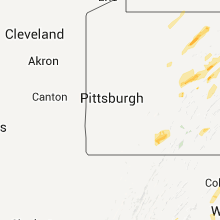
Pennsylvania
| Local Time | Report Details |
|---|---|
| 8:05 PM UTC | Trees down on allison rd near morrison par in venango county PA, 64.6 miles NNE of Pittsburgh, PA |
| 8:05 PM UTC | Trees down on 3rd st and cemetery r in venango county PA, 82.4 miles NNE of Pittsburgh, PA |
| 8:05 PM UTC | Trees down on walnut bend rd in venango county PA, 74.1 miles NNE of Pittsburgh, PA |
| 8:15 PM UTC | Several trees and wires down in crawford county PA, 81.3 miles E of Cleveland, OH |
| 8:37 PM UTC | Trees down on walnut bend rd in venango county PA, 74.1 miles NNE of Pittsburgh, PA |
| 8:38 PM UTC | Trees down on 3rd st and cemetery rd in venango county PA, 82.4 miles NNE of Pittsburgh, PA |
| 8:40 PM UTC | Storm damage reported in erie county PA, 84.8 miles SW of Buffalo, NY |
| 8:42 PM UTC | Storm damage reported in erie county PA, 81.9 miles SSW of Buffalo, NY |
| 8:50 PM UTC | Shed damaged and tree down on quarry ave. public reported a funnel cloud in clearfield county PA, 52.2 miles WNW of State College, PA |
| 8:50 PM UTC | Trees and wires down in the city in clearfield county PA, 52.2 miles WNW of State College, PA |
| 8:50 PM UTC | Parts of roofs and sidings torn off building in jefferson county PA, 54.9 miles WNW of State College, PA |
| 8:50 PM UTC | Trees and power lines down on main s in jefferson county PA, 54.9 miles WNW of State College, PA |
| 8:50 PM UTC | Trees and power lines down on wayne rd in winslow tw in jefferson county PA, 57.6 miles WNW of State College, PA |
| 9:10 PM UTC | Trees and wires down in the city in clearfield county PA, 52.2 miles WNW of State College, PA |
| 9:15 PM UTC | Shed damaged and tree down on quarry ave in clearfield county PA, 52.2 miles WNW of State College, PA |
| 9:15 PM UTC | Shed damaged and tree down on quarry ave. public reported a funnel cloud in clearfield county PA, 52.2 miles WNW of State College, PA |
| 10:15 PM UTC | Several trees down and water over road in potter county PA, 59.6 miles NNW of State College, PA |
| 10:29 PM UTC | Several trees down and water over road in potter county PA, 59.6 miles NNW of State College, PA |
| 11:15 PM UTC | Trees down in perry county PA, 44.1 miles ESE of State College, PA |
| 11:48 PM UTC | Numerous trees down. 70x35 ft barn destroyed. corn bin lost. house moved 1ft off of foundation. 621 w. main st elkland bor in tioga county PA, 87 miles NNE of State College, PA |
| 11:50 PM UTC | Several trees down on power line in tioga county PA, 87.4 miles NNE of State College, PA |
| 4:26 AM UTC | One tree down in somerset county PA, 63.7 miles SE of Pittsburgh, PA |
| 4:30 AM UTC | One tree down in somerset county PA, 63.7 miles SE of Pittsburgh, PA |
| 4:35 AM UTC | Quarter sized hail reported near Berlin, PA, 66 miles ESE of Pittsburgh, PA |
| 4:44 AM UTC | Quarter sized hail reported near Berlin, PA, 66 miles ESE of Pittsburgh, PA |
| 5:35 AM UTC | Half Dollar sized hail reported near Martinsburg, PA, 41.2 miles SW of State College, PA |
| 6:30 AM UTC | Trees dow in centre county PA, 4.1 miles ESE of State College, PA |
| 6:40 AM UTC | Trees dow in centre county PA, 10 miles ENE of State College, PA |
| 6:45 AM UTC | Trees dow in mifflin county PA, 27.9 miles S of State College, PA |
| 6:50 AM UTC | Trees dow in centre county PA, 4.1 miles ESE of State College, PA |
| 6:50 AM UTC | Trees dow in centre county PA, 10 miles ENE of State College, PA |
| 6:57 AM UTC | Trees dow in mifflin county PA, 27.9 miles S of State College, PA |
| 7:00 AM UTC | Numerous trees down and building damage in juniata county PA, 32.3 miles SSE of State College, PA |
| 7:00 AM UTC | Significant damage to 4 barns alg rt 850 off of rt 75. silo top blown off. portion of 3-stall barn destroyed. large machine shed destroyed. lots of debris. numerous tre in juniata county PA, 32.3 miles SSE of State College, PA |
| 7:07 AM UTC | Trees down on route 22 in mifflin county PA, 20.3 miles SE of State College, PA |
| 7:20 AM UTC | Trees down in juniata county PA, 32.5 miles ESE of State College, PA |
| 8:00 AM UTC | Quarter sized hail reported near Dauphin, PA, 57 miles ESE of State College, PA |
| 8:07 AM UTC | Tree on house in northumberland county PA, 58.5 miles E of State College, PA |
| 8:14 AM UTC | Trees down in northumberland county PA, 66.3 miles E of State College, PA |
| 8:15 AM UTC | Trees down in adams county PA, 55.8 miles NW of Baltimore, MD |
| 8:30 AM UTC | Multiple trees down in schuylkill county PA, 68.9 miles SW of Scranton, PA |
| 8:35 AM UTC | Numerous trees down in columbia county PA, 50.7 miles SW of Scranton, PA |
| 8:50 AM UTC | At least 60 large trees down in a swat in luzerne county PA, 20.2 miles WSW of Scranton, PA |
| 8:55 AM UTC | Tree down on house as well in lebanon county PA, 76.2 miles NNE of Baltimore, MD |
| 8:55 AM UTC | Straight line winds of around 95 mph occurred...with a path length of 1 mile...and a path width of around 500 yards. mainly tree damage occurred. the damage was concent in luzerne county PA, 20.2 miles WSW of Scranton, PA |
| 9:20 AM UTC | Straight line winds of around 80 mph occurred...with a path length of 0.25 miles...and a path width of about 100 yards. tree damage...and some structural damage occurre in wyoming county PA, 12.1 miles WNW of Scranton, PA |
| 9:26 AM UTC | Pennsylvania power and light truck blown over -- time radar estimated in lackawanna county PA, 11.7 miles N of Scranton, PA |
| 9:30 AM UTC | Large apple bins damaged blown uphill...utility pole and trees uprooted...wires dow in adams county PA, 55.8 miles NW of Baltimore, MD |
| 9:35 AM UTC | Pennsylvania power and light truck blown over in lackawanna county PA, 11.7 miles N of Scranton, PA |
| 9:42 AM UTC | Building blown over on route 374 -- possible tornado in bradford county PA, 39.8 miles NW of Scranton, PA |
| 9:42 AM UTC | Roof blown off moble home -- possible tornado in bradford county PA, 39.8 miles NW of Scranton, PA |
| 9:42 AM UTC | Tree on house...vauter rd -- possible tornado in bradford county PA, 39.8 miles NW of Scranton, PA |
| 9:42 AM UTC | Widespread trees down in adams county PA, 51.7 miles NNW of Baltimore, MD |
| 9:47 AM UTC | Numerous trees down. man reported front end of car lifted off groun in york county PA, 57.6 miles NNW of Baltimore, MD |
| 10:02 AM UTC | Several 75 to 80 foot trees down. possible tornad in wayne county PA, 29.6 miles ENE of Scranton, PA |
| 10:27 AM UTC | Widespread trees down in juniata county PA, 32.3 miles SSE of State College, PA |
| 10:35 AM UTC | Trees across reeds creek road. possible structural collaps in lebanon county PA, 72.4 miles ESE of State College, PA |
| 10:48 AM UTC | Trees across reeds creek road. possible structural collaps in lebanon county PA, 72.4 miles ESE of State College, PA |
| 11:30 AM UTC | Numerous trees down in columbia county PA, 50.7 miles SW of Scranton, PA |
New York
| Local Time | Report Details |
|---|---|
| 9:20 PM UTC | Tree down between ellery center and maple springs in chautauqua county NY, 53.9 miles SSW of Buffalo, NY |
| 10:11 PM UTC | Trees down near wesleyan church at rt 1 in allegany county NY, 48.3 miles SE of Buffalo, NY |
| 10:48 PM UTC | Multiple trees dow in allegany county NY, 73.8 miles SE of Buffalo, NY |
| 10:50 PM UTC | Tree fell on hous in allegany county NY, 73.8 miles SE of Buffalo, NY |
| 10:50 PM UTC | Wires dow in livingston county NY, 67.9 miles ESE of Buffalo, NY |
| 11:15 PM UTC | Roof off dansville h in livingston county NY, 64 miles ESE of Buffalo, NY |
| 11:25 PM UTC | Lines down at rt5 and 2 in ontario county NY, 58.5 miles W of Syracuse, NY |
| 12:00 AM UTC | Roof blown off house in steuben county NY, 78 miles SW of Syracuse, NY |
| 12:05 AM UTC | Large tree branches broken in steuben county NY, 78 miles SW of Syracuse, NY |
| 12:20 AM UTC | Trees down in big flats... horeheads and alpine in chemung county in chemung county NY, 74.4 miles SSW of Syracuse, NY |
| 12:25 AM UTC | Significant damage to barn trees and power lines down in schuyler county NY, 62.4 miles SSW of Syracuse, NY |
| 12:32 AM UTC | 4 large trees down in schuyler county NY, 59.8 miles SW of Syracuse, NY |
| 1:55 AM UTC | Trees and powerlines down across route 79 in broome county NY, 55.8 miles N of Scranton, PA |
| 2:30 AM UTC | Trees down in south new berlin in chenango county NY, 50.6 miles SE of Syracuse, NY |
| 2:45 AM UTC | Trees down in gilbertsvill in otsego county NY, 58.1 miles SE of Syracuse, NY |
| 3:20 AM UTC | A large tree and wires down on howard street in the village. spotter measured a wind gust of 41 mph just outside the villag in herkimer county NY, 46.5 miles WNW of Schenectady, NY |
| 5:25 AM UTC | Several homes severely damaged in chemung county NY, 65.7 miles SSW of Syracuse, NY |
| 5:45 AM UTC | Straight line winds of nearly 100 mph with a path length of 1.70 miles and a width of 0.45 miles produced significant tree damage. trees fell on the roof of a house. fu in tompkins county NY, 51.2 miles SSW of Syracuse, NY |
| 5:50 AM UTC | Trees snapped off near the ithaca-danby town line south of ithaca college in tompkins county NY, 45.8 miles SSW of Syracuse, NY |
| 5:50 AM UTC | Numerous trees down in tioga county NY, 59.9 miles SSW of Syracuse, NY |
| 6:16 AM UTC | Possible tornado. several trees. ansd poles down...roof off hous in tompkins county NY, 33.7 miles SSW of Syracuse, NY |
| 7:20 AM UTC | Possible tornado. numerous trees down north road and center road area in chenango county NY, 37.7 miles SSE of Syracuse, NY |
| 8:00 AM UTC | A significant swath of trees were blown down on waldron road. these trees were all pointing to the southeast in a slightly divergent pattern. this damage occurred concu in chenango county NY, 45.7 miles SSE of Syracuse, NY |
| 8:25 AM UTC | Trees down. structural damage reporte in oneida county NY, 46.6 miles E of Syracuse, NY |
| 8:59 AM UTC | Partial roof including hvac system off building -- time radar estimated in chemung county NY, 74.4 miles SSW of Syracuse, NY |
| 9:00 AM UTC | Significant downburst wind event hit the afton area around 5am edt on april 28th with estimated winds of 95 mph and a path length of 4 miles. the width of the downburst in chenango county NY, 57 miles N of Scranton, PA |
| 9:00 AM UTC | Trees down in conklin and the town of binghamto in broome county NY, 43.4 miles N of Scranton, PA |
| 9:10 AM UTC | Tree damage and structural damage between county route 17 and rounds road in chenango county NY, 61.9 miles SSE of Syracuse, NY |
| 9:15 AM UTC | Multiple trees down in herkimer county NY, 54.6 miles E of Syracuse, NY |
| 9:35 AM UTC | Three pine trees down on state route 170a south of route 2 in herkimer county NY, 48.6 miles WNW of Schenectady, NY |
| 9:40 AM UTC | Three pine trees sheaered and/or uprooted down on state route 170a south of route 29. three sheds blown apart and one rolled. bricks missing from chimney of hous in herkimer county NY, 48.6 miles WNW of Schenectady, NY |
| 10:29 AM UTC | Blanchard road tree down on home in fulton county NY, 25.7 miles WNW of Schenectady, NY |
| 11:00 AM UTC | Rt 9n trees and wires down in warren county NY, 52.1 miles NNE of Schenectady, NY |
| 11:25 AM UTC | Many trees limbs down in central park in schenectady county NY, 1 miles SSE of Schenectady, NY |
| 11:30 AM UTC | Multiple trees and wires dow in schoharie county NY, 24.6 miles SW of Schenectady, NY |
| 11:50 AM UTC | Rt 32 between rt 50 and jewell road closed due to down wires until 1030 am in saratoga county NY, 27.9 miles NE of Schenectady, NY |
West Virginia
| Local Time | Report Details |
|---|---|
| 10:35 PM UTC | Storm damage reported in upshur county WV, 23.5 miles WNW of Elkins, WV |
| 1:44 AM UTC | Quarter sized hail reported near Oceana, WV, 43.1 miles S of Charleston, WV |
| 2:03 AM UTC | Numerous trees down on wv 4 near procious in clay county WV, 25.5 miles ENE of Charleston, WV |
| 2:12 AM UTC | Numerous trees down on county route 22 near bickmore in clay county WV, 28.8 miles E of Charleston, WV |
| 2:12 AM UTC | Trees and powerlines down in raleigh county WV, 41.4 miles SE of Charleston, WV |
| 2:12 AM UTC | Trees down in raleigh county WV, 48.8 miles SSE of Charleston, WV |
| 2:15 AM UTC | Quarter sized hail reported near Mt Hope, WV, 41.2 miles SE of Charleston, WV |
| 2:20 AM UTC | Half Dollar sized hail reported near Mt Hope, WV, 39.3 miles SE of Charleston, WV |
| 2:20 AM UTC | Trees dow in raleigh county WV, 39.3 miles SE of Charleston, WV |
| 2:23 AM UTC | Tree down on lester highway in glen white in raleigh county WV, 47 miles SSE of Charleston, WV |
| 2:26 AM UTC | Tree down on joe cooper farm road in white oak in raleigh county WV, 55.1 miles SE of Charleston, WV |
| 2:28 AM UTC | Trees down on rte 41 in fayette county WV, 44.1 miles SE of Charleston, WV |
| 2:32 AM UTC | 3-4 trees down on route 7 near gassaway in braxton county WV, 52 miles ENE of Charleston, WV |
| 2:39 AM UTC | Several trees down near bingham v in greenbrier county WV, 50.1 miles ESE of Charleston, WV |
| 3:11 AM UTC | Half Dollar sized hail reported near Ghent, WV, 58.1 miles SSE of Charleston, WV |
| 3:15 AM UTC | Quarter sized hail reported near Bluefield, WV, 67.2 miles W of Roanoke, VA |
| 3:16 AM UTC | Quarter sized hail reported near Cool Ridge, WV, 56 miles SSE of Charleston, WV |
| 3:40 AM UTC | Several small trees down in seneca state forest in pocahontas county WV, 38.5 miles S of Elkins, WV |
| 3:45 AM UTC | Roofs blown off buildings...multiple trees down in randolph county WV, 0.5 miles NW of Elkins, WV |
| 3:45 AM UTC | Structural damage in the industrial park...trees down on houses in randolph county WV, 0.5 miles NW of Elkins, WV |
| 3:45 AM UTC | Trees dow in randolph county WV, 1.4 miles NE of Elkins, WV |
| 3:50 AM UTC | Several trees down in dawson and clintonville wv in greenbrier county WV, 57.5 miles NW of Roanoke, VA |
| 4:01 AM UTC | Greenbrier eoc reports damage in several towns across the county. numerous trees are down and some structures are damaged. the eoc are still collecting specific details in greenbrier county WV, 45.9 miles NW of Roanoke, VA |
| 4:10 AM UTC | 3 homes damaged due to falling trees in the lewisburg are in greenbrier county WV, 45.9 miles NW of Roanoke, VA |
| 4:10 AM UTC | Several large trees were snapped or blown down along davis stuart roa in greenbrier county WV, 44.7 miles NW of Roanoke, VA |
| 4:13 AM UTC | Trees down on rt 219 north of interstate 64. time estimated by rada in greenbrier county WV, 46.7 miles NW of Roanoke, VA |
| 4:40 AM UTC | Trees down on route 28 between petersburg and hopevill in grant county WV, 33.9 miles E of Elkins, WV |
| 4:40 AM UTC | Trees down at thornwood near intersection of rts 250 and 2 in pocahontas county WV, 24.9 miles SSE of Elkins, WV |
| 4:40 AM UTC | Several small trees down in seneca state forest in pocahontas county WV, 38.5 miles S of Elkins, WV |
| 4:45 AM UTC | Trees down between petersburg and maysville on route 4 in grant county WV, 40.3 miles ENE of Elkins, WV |
| 5:00 AM UTC | Several trees down in whitmer in randolph county WV, 19.2 miles ESE of Elkins, WV |
| 5:55 AM UTC | 1 tree down on waiteville r in monroe county WV, 28.3 miles NW of Roanoke, VA |
| 7:05 AM UTC | Tree down on whisper valley road in hampshire county WV, 67.6 miles ENE of Elkins, WV |
| 7:22 AM UTC | Trees down at waites run. much of wardensville w o powe in hardy county WV, 68.1 miles E of Elkins, WV |
| 8:13 AM UTC | Trees down on rt 219 north of interstate 64. time estimated by rada in greenbrier county WV, 46.7 miles NW of Roanoke, VA |
Maryland
| Local Time | Report Details |
|---|---|
| 11:24 PM UTC | Large branches and shingles on allentown road. a big road sign blown down near andrews airforce bas in prince georges county MD, 35.8 miles SSW of Baltimore, MD |
| 11:25 PM UTC | At least 9 tree branches 8-10 inches in diameter as well as a large tree 18-20 inches in diameter blown in the direction from andrew afb toward allentown roa in prince georges county MD, 35.6 miles SSW of Baltimore, MD |
| 5:22 AM UTC | Several tree limbs blown down near corriganville fire station in corriganville... md. tree limbs about one and one half inches in diamete in allegany county MD, 77.4 miles NE of Elkins, WV |
| 5:26 AM UTC | Tree fell onto a house along packhorse road. numerous trees were down along packhorse road and greene ridge roa in allegany county MD, 82.6 miles ENE of Elkins, WV |
| 5:35 AM UTC | Tree down at intersection of mertens rd and oldtown orleans rd se in allegany county MD, 87.7 miles ENE of Elkins, WV |
| 9:17 AM UTC | Non-tornadic thunderstorm wind felled trees in the vicinity of poole road and holter roa in frederick county MD, 49.3 miles W of Baltimore, MD |
| 10:46 AM UTC | Trampoline lifted onto power pole and approximately 30 yards of fencing was destroyed in montgomery county MD, 44.6 miles WSW of Baltimore, MD |
| 10:49 AM UTC | Trees down over route 109 in montgomery county MD, 41.6 miles W of Baltimore, MD |
| 10:49 AM UTC | Multiple trees down in montgomery county MD, 43.6 miles W of Baltimore, MD |
| 10:49 AM UTC | Trees down off big woods road in montgomery county MD, 43.4 miles W of Baltimore, MD |
| 11:20 AM UTC | Storm damage reported in frederick county MD, 34.5 miles WNW of Baltimore, MD |
Florida
| Local Time | Report Details |
|---|---|
| 9:52 AM UTC | Possible tornado caused damage to the marianna municipal airport. roof reported ripped off house nearb in jackson county FL, 59.9 miles WNW of Tallahassee, FL |
Connect with Interactive Hail Maps