

Hail Map for Tuesday, June 3, 2014

Number of Impacted Households on 6/3/2014
0
Impacted by 1" or Larger Hail
0
Impacted by 1.75" or Larger Hail
0
Impacted by 2.5" or Larger Hail
Square Miles of Populated Area Impacted on 6/3/2014
0
Impacted by 1" or Larger Hail
0
Impacted by 1.75" or Larger Hail
0
Impacted by 2.5" or Larger Hail


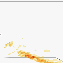


Cities Most Affected by Hail Storms of 6/3/2014
| Hail Size | Demographics of Zip Codes Affected | ||||||
|---|---|---|---|---|---|---|---|
| City | Count | Average | Largest | Pop Density | House Value | Income | Age |
| Torrington, WY | 5 | 2.10 | 2.50 | 13 | $79k | $33.0k | 43.0 |
| Blair, NE | 3 | 2.92 | 4.25 | 91 | $119k | $47.0k | 38.7 |
| Norfolk, NE | 3 | 2.67 | 2.75 | 163 | $84k | $36.2k | 36.2 |
| Broken Bow, NE | 4 | 1.88 | 2.00 | 12 | $57k | $31.8k | 42.8 |
| Weston, NE | 3 | 2.42 | 3.00 | 8 | $65k | $38.0k | 44.7 |
| Hooper, NE | 3 | 2.33 | 2.75 | 9 | $78k | $39.3k | 44.5 |
| Eagleville, MO | 3 | 2.25 | 2.75 | 10 | $41k | $29.3k | 36.1 |
| Lucerne, MO | 2 | 3.13 | 3.50 | 3 | $15k | $32.2k | 46.0 |
| Blanchard, IA | 3 | 2.00 | 2.50 | 5 | $12k | $21.0k | 48.5 |
| York, NE | 3 | 1.75 | 1.75 | 51 | $79k | $36.8k | 39.9 |
| Atkinson, NE | 3 | 1.75 | 1.75 | 2 | $52k | $30.6k | 47.1 |
| Newport, NE | 3 | 1.75 | 1.75 | 1 | $15k | $32.7k | 50.8 |
| Lisco, NE | 2 | 2.25 | 2.75 | 0 | $59k | $29.3k | 45.4 |
| Lamoni, IA | 2 | 2.25 | 2.50 | 27 | $71k | $26.0k | 25.0 |
| Minatare, NE | 1 | 4.25 | 4.25 | 9 | $46k | $31.0k | 41.7 |
| Wilber, NE | 2 | 2.13 | 2.50 | 15 | $64k | $36.4k | 39.7 |
| Bayard, NE | 1 | 4.25 | 4.25 | 5 | $52k | $30.8k | 43.5 |
| Lenox, IA | 2 | 1.88 | 2.00 | 16 | $48k | $31.5k | 43.0 |
| Burwell, NE | 2 | 1.75 | 1.75 | 1 | $39k | $26.8k | 50.4 |
| Mc Cool Junction, NE | 2 | 1.75 | 1.75 | 6 | $69k | $36.7k | 40.8 |
| Corning, IA | 2 | 1.75 | 1.75 | 12 | $52k | $29.9k | 46.8 |
| Thedford, NE | 2 | 1.75 | 1.75 | 0 | $39k | $31.7k | 46.4 |
| Nehawka, NE | 2 | 1.75 | 1.75 | 7 | $78k | $50.2k | 41.8 |
| Fort Calhoun, NE | 1 | 2.75 | 2.75 | 58 | $125k | $55.8k | 45.3 |
| Greenwood, NE | 1 | 2.75 | 2.75 | 15 | $86k | $46.0k | 41.8 |
| Orchard, NE | 1 | 2.75 | 2.75 | 3 | $25k | $23.8k | 48.0 |
| Stanton, NE | 1 | 2.75 | 2.75 | 8 | $64k | $35.0k | 42.1 |
| Skidmore, MO | 1 | 2.75 | 2.75 | 5 | $23k | $27.7k | 44.9 |
| Duncan, NE | 1 | 2.75 | 2.75 | 0 | $65k | $35.8k | 39.6 |
| Broadwater, NE | 1 | 2.75 | 2.75 | 1 | $23k | $26.8k | 47.6 |
| Scottsbluff, NE | 1 | 2.50 | 2.50 | 157 | $75k | $31.0k | 37.9 |
| Alliance, NE | 1 | 2.50 | 2.50 | 10 | $73k | $39.4k | 40.8 |
| Malmo, NE | 1 | 2.50 | 2.50 | 8 | $65k | $33.4k | 39.4 |
| Crookston, NE | 1 | 2.50 | 2.50 | 1 | $26k | $27.0k | 46.0 |
| Clearfield, IA | 1 | 2.00 | 2.00 | 7 | $25k | $27.6k | 46.7 |
| Callaway, NE | 1 | 2.00 | 2.00 | 2 | $54k | $33.0k | 47.3 |
| New Market, IA | 1 | 2.00 | 2.00 | 10 | $40k | $35.1k | 44.5 |
| Mount Ayr, IA | 1 | 2.00 | 2.00 | 17 | $52k | $29.3k | 47.4 |
| Braddyville, IA | 1 | 2.00 | 2.00 | 5 | $44k | $40.6k | 51.3 |
| Mullen, NE | 1 | 2.00 | 2.00 | 0 | $41k | $28.7k | 49.6 |
| Arlington, NE | 1 | 1.75 | 1.75 | 18 | $100k | $47.5k | 41.5 |
| Arthur, NE | 1 | 1.75 | 1.75 | 0 | $48k | $30.5k | 43.8 |
| Unionville, MO | 1 | 1.75 | 1.75 | 15 | $49k | $24.5k | 44.7 |
| Page, NE | 1 | 1.75 | 1.75 | 2 | $40k | $30.6k | 49.2 |
| Princeton, MO | 1 | 1.75 | 1.75 | 10 | $35k | $31.0k | 41.9 |
| Rockville, NE | 1 | 1.75 | 1.75 | 3 | $35k | $33.4k | 47.5 |
| David City, NE | 1 | 1.75 | 1.75 | 25 | $67k | $36.1k | 42.0 |
| Saint Paul, NE | 1 | 1.75 | 1.75 | 18 | $69k | $33.0k | 42.3 |
| Chapman, NE | 1 | 1.75 | 1.75 | 7 | $65k | $38.1k | 43.4 |
| Springdale, WA | 1 | 1.75 | 1.75 | 7 | $75k | $24.8k | 45.0 |
| Osceola, NE | 1 | 1.75 | 1.75 | 5 | $61k | $37.8k | 45.0 |
| Dorchester, NE | 1 | 1.75 | 1.75 | 7 | $62k | $34.4k | 40.9 |
| Spalding, NE | 1 | 1.75 | 1.75 | 1 | $45k | $30.8k | 44.6 |
| Diller, NE | 1 | 1.75 | 1.75 | 5 | $39k | $37.2k | 44.9 |
| Plainview, NE | 1 | 1.75 | 1.75 | 7 | $50k | $29.0k | 45.4 |
| Blythedale, MO | 1 | 1.75 | 1.75 | 6 | $22k | $27.8k | 48.6 |
| Princeton, KS | 1 | 1.75 | 1.75 | 11 | $62k | $39.9k | 41.6 |
| Beemer, NE | 1 | 1.75 | 1.75 | 10 | $46k | $30.8k | 50.5 |
| Pilger, NE | 1 | 1.75 | 1.75 | 6 | $52k | $33.2k | 46.9 |
| Rock Port, MO | 1 | 1.75 | 1.75 | 16 | $59k | $30.9k | 46.2 |
| Friend, NE | 1 | 1.75 | 1.75 | 12 | $73k | $35.6k | 45.3 |
| Davey, NE | 1 | 1.75 | 1.75 | 19 | $117k | $60.9k | 44.7 |
| Garden City, KS | 1 | 1.75 | 1.75 | 44 | $85k | $38.1k | 30.2 |
| Bassett, NE | 1 | 1.75 | 1.75 | 1 | $41k | $25.5k | 50.4 |
| Council Bluffs, IA | 1 | 1.75 | 1.75 | 1468 | $68k | $34.1k | 34.9 |
| Louisville, NE | 1 | 1.75 | 1.75 | 27 | $91k | $45.6k | 42.6 |
| Ericson, NE | 1 | 1.75 | 1.75 | 2 | $33k | $26.2k | 52.1 |
| Royal, NE | 1 | 1.75 | 1.75 | 4 | $19k | $29.5k | 44.7 |
| Wisner, NE | 1 | 1.75 | 1.75 | 8 | $55k | $33.5k | 42.9 |
| Wood Lake, NE | 1 | 1.75 | 1.75 | 0 | $31k | $30.8k | 43.2 |
| Mission, SD | 1 | 1.75 | 1.75 | 1 | $37k | $22.7k | 24.5 |
| Lineville, IA | 1 | 1.75 | 1.75 | 6 | $35k | $33.6k | 44.0 |
| Missouri Valley, IA | 1 | 1.75 | 1.75 | 34 | $84k | $41.2k | 42.0 |
| North Platte, NE | 1 | 1.75 | 1.75 | 50 | $79k | $36.3k | 38.7 |
| Stuart, NE | 1 | 1.75 | 1.75 | 2 | $53k | $30.7k | 47.1 |
| Wahoo, NE | 1 | 1.75 | 1.75 | 58 | $87k | $36.5k | 39.6 |
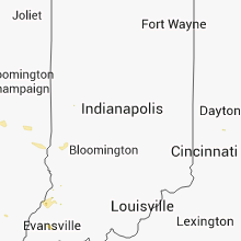
Hail and Wind Damage Spotted on 6/3/2014
Filter by Report Type:Hail ReportsWind Reports
States Impacted
South Dakota, Missouri, Nebraska, Pennsylvania, Ohio, Montana, Iowa, New York, Massachusetts, Kentucky, Wyoming, West Virginia, Washington, New Mexico, Kansas, IllinoisSouth Dakota
| Local Time | Report Details |
|---|---|
| 8:45 AM MDT | Quarter sized hail reported near Kyle, SD, 58.9 miles ESE of Rapid City, SD, this is also 20 miles se of scenic. |
| 8:45 AM MDT | Quarter sized hail reported near Kyle, SD, 59.2 miles SE of Rapid City, SD |
| 9:20 AM MDT | Quarter sized hail reported near Interior, SD, 68.6 miles ESE of Rapid City, SD, most of the hail was 1/2 inch with a few the size of a quarter. |
| 9:20 AM MDT | Quarter sized hail reported near Interior, SD, 70.8 miles ESE of Rapid City, SD, most of the hail was 1/2 inch with a few the size of a quarter. |
| 10:25 AM CDT | Golf Ball sized hail reported near Mission, SD, 33.7 miles NNW of Valentine, NE, ground is covered with hail |
| 11:10 AM CDT | Quarter sized hail reported near Mission, SD, 10.3 miles NNW of Valentine, NE, hail lasted 10 minutes from 1010 am to 1020 am mdt. |
| 6:50 PM CDT | Quarter sized hail reported near Saint Francis, SD, 26.3 miles NW of Valentine, NE |
| 7:15 PM CDT | Quarter sized hail reported near Mission, SD, 16.6 miles N of Valentine, NE |
| 8:01 PM CDT | Quarter sized hail reported near Geddes, SD, 55.4 miles N of Oneill, NE, mostly marble size but a few as large as quarters |
Missouri
| Local Time | Report Details |
|---|---|
| 10:47 AM CDT | Parts of trees and pole barns along 48 highway west of king city in gentry county MO, 65.3 miles N of Kansas City, MO |
| 3:35 PM CDT | Quarter sized hail reported near Westboro, MO, 59.1 miles SE of Omaha, NE |
| 4:15 PM CDT | Half Dollar sized hail reported near Hopkins, MO, 72.9 miles SE of Omaha, NE |
| 4:26 PM CDT | Quarter sized hail reported near Hopkins, MO, 75.6 miles SE of Omaha, NE |
| 5:49 PM CDT | Quarter sized hail reported near Eagleville, MO, 74 miles SSW of Des Moines, IA |
| 5:52 PM CDT | Baseball sized hail reported near Eagleville, MO, 75.5 miles SSW of Des Moines, IA |
| 5:58 PM CDT | Hen Egg sized hail reported near Eagleville, MO, 75.8 miles SSW of Des Moines, IA, strong winds and 0.51 inches of rain thus far. |
| 6:02 PM CDT | Golf Ball sized hail reported near Eagleville, MO, 75.3 miles SSW of Des Moines, IA |
| 6:11 PM CDT | Golf Ball sized hail reported near Blythedale, MO, 78 miles S of Des Moines, IA |
| 6:40 PM CDT | 8 inch limbs snapped... 30 foot steel ham tower bent to the groun in mercer county MO, 82.1 miles S of Des Moines, IA |
| 6:47 PM CDT | Golf Ball sized hail reported near Princeton, MO, 82.1 miles S of Des Moines, IA, golf ball sized hail and 70 mph winds reported by spotter. |
| 7:29 PM CDT | Baseball sized hail reported near Lucerne, MO, 79.5 miles SSE of Des Moines, IA |
| 7:29 PM CDT | Tea Cup sized hail reported near Lucerne, MO, 79.5 miles SSE of Des Moines, IA |
| 7:37 PM CDT | Golf Ball sized hail reported near Unionville, MO, 76 miles W of Kahoka, MO, relayed via emergency manager. |
| 8:02 PM CDT | Ping Pong Ball sized hail reported near Galt, MO, 86.8 miles W of Kahoka, MO, between osgood and harris |
| 8:11 PM CDT | Quarter sized hail reported near Spickard, MO, 91.8 miles S of Des Moines, IA, 1 inch hail covering the ground on the grundy county line |
| 8:17 PM CDT | Quarter sized hail reported near Harris, MO, 86.4 miles W of Kahoka, MO |
| 8:54 PM CDT | Storm damage reported in adair county MO, 46.4 miles W of Kahoka, MO |
| 9:11 PM CDT | Quarter sized hail reported near Westboro, MO, 58.8 miles SSE of Omaha, NE |
| 9:14 PM CDT | Golf Ball sized hail reported near Rock Port, MO, 55.7 miles SSE of Omaha, NE, reported via facebook |
| 9:14 PM CDT | With 1 inch hai in atchison county MO, 59.1 miles SSE of Omaha, NE |
| 9:14 PM CDT | Storm damage reported in atchison county MO, 52.5 miles SSE of Omaha, NE |
| 9:15 PM CDT | Quarter sized hail reported near Rock Port, MO, 52.4 miles SSE of Omaha, NE, also winds to 60 mph |
| 9:18 PM CDT | Storm damage reported in adair county MO, 47.9 miles WSW of Kahoka, MO |
| 9:30 PM CDT | Ping Pong Ball sized hail reported near Tarkio, MO, 62.6 miles SSE of Omaha, NE |
| 9:35 PM CDT | Trees down and uprooted and signs blown ove in knox county MO, 35.9 miles WSW of Kahoka, MO |
| 9:37 PM CDT | Estimated 55-60 mph wind in scotland county MO, 23.9 miles W of Kahoka, MO |
| 9:40 PM CDT | Trees down and uprooted. damage to sign in knox county MO, 29.4 miles SW of Kahoka, MO |
| 9:42 PM CDT | Trees bent nearly over...with torrential rain also in scotland county MO, 23.9 miles W of Kahoka, MO |
| 9:43 PM CDT | Numerous large limbs and other debris down throughout edina closing approximately half of roadways in and around tow in knox county MO, 29.4 miles SW of Kahoka, MO |
| 9:45 PM CDT | Large trees limbs down in the roads. wind gust estimated 60 mp in knox county MO, 29.4 miles SW of Kahoka, MO |
| 9:45 PM CDT | Heavy tree damage also reported in macon county MO, 48.9 miles WSW of Kahoka, MO |
| 10:00 PM CDT | Measured by missouri mesonet in knox county MO, 38.4 miles SW of Kahoka, MO |
| 10:00 PM CDT | Baseball sized hail reported near Skidmore, MO, 80.8 miles SE of Omaha, NE, also power outages widespread in the county... multiple trees down... and widespread flash flooding. |
| 10:02 PM CDT | Numerous large tree limbs down all over town...time estimated from rada in scotland county MO, 23.9 miles W of Kahoka, MO |
| 10:02 PM CDT | Via e-spotte in scotland county MO, 23.9 miles W of Kahoka, MO |
| 10:05 PM CDT | Storm damage reported in lewis county MO, 24 miles SSW of Kahoka, MO |
| 10:05 PM CDT | Storm damage reported in lewis county MO, 22.7 miles SSW of Kahoka, MO |
| 10:07 PM CDT | Tree limbs down in lewis county MO, 24 miles SSW of Kahoka, MO |
| 10:08 PM CDT | Power lines down over route a in nodaway county MO, 79.8 miles NNW of Kansas City, MO |
| 10:08 PM CDT | 3 foot wide tree down across highway 15 in tow in scotland county MO, 23.9 miles W of Kahoka, MO |
| 10:47 PM CDT | Parts of trees and pole barns along 48 highway west of king city in gentry county MO, 65.3 miles N of Kansas City, MO |
| 11:15 PM CDT | 8 to 12 inch tree fell on a garage at a residence in union sta in dekalb county MO, 60.5 miles N of Kansas City, MO |
| 11:25 PM CDT | Storm damage reported in harrison county MO, 85.7 miles NNE of Kansas City, MO |
| 11:49 PM CDT | Large tree down blocking the intersection of 7th and mcdonald in st josep in buchanan county MO, 48.2 miles NNW of Kansas City, MO |
| 11:51 PM CDT | Power also out in grundy county MO, 84.5 miles NNE of Kansas City, MO |
| 12:27 AM CDT | Trees down on power lines causing power outage in platte county MO, 30.5 miles NNW of Kansas City, MO |
| 12:33 AM CDT | Storm damage reported in caldwell county MO, 47.1 miles NE of Kansas City, MO |
| 12:38 AM CDT | Storm damage reported in livingston county MO, 72.8 miles NE of Kansas City, MO |
| 12:46 AM CDT | Storm damage reported in clay county MO, 27.3 miles NNE of Kansas City, MO |
| 1:27 AM CDT | Trees down on power lines causing power outage in platte county MO, 30.5 miles NNW of Kansas City, MO |
| 2:00 AM CDT | Trees down and roof damage in saline county MO, 43.2 miles WNW of Columbia, MO |
| 2:18 AM CDT | Large limbs up to 10 in in diameter down on signal hill. winds estimated 50 to 60 mph in clay county MO, 2.8 miles NNE of Kansas City, MO |
| 2:40 AM CDT | Large tree on hom in jackson county MO, 8.5 miles S of Kansas City, MO |
| 2:50 AM CDT | 5 inch tree branches down on back porch of retired nws employe in jackson county MO, 21.8 miles SE of Kansas City, MO |
| 4:05 AM CDT | School lost portion of roof. numerous trees and fences down across tow in cooper county MO, 16.9 miles SW of Columbia, MO |
| 4:24 AM CDT | Barn partially ripped off a barn in boone county MO, 15.2 miles SSE of Columbia, MO |
| 4:24 AM CDT | Estimated 70-75 mph winds at komu-tv south of columbia with dime sized hail in boone county MO, 0.3 miles SE of Columbia, MO |
| 6:20 AM CDT | 3 power poles snapped along highway a in franklin county MO, 50.8 miles WSW of Saint Louis, MO |
| 6:34 AM CDT | Man is trapped in a car with trees down on the car and on house in franklin county MO, 45.6 miles WSW of Saint Louis, MO |
| 6:40 AM CDT | Trees down along highway 47 just south of tow in franklin county MO, 46 miles WSW of Saint Louis, MO |
| 6:48 AM CDT | 8-10 inch limbs broken off about halfway up the tree in franklin county MO, 36.4 miles WSW of Saint Louis, MO |
Nebraska
| Local Time | Report Details |
|---|---|
| 10:55 AM CDT | Quarter sized hail reported near Kilgore, NE, 21.1 miles WNW of Valentine, NE |
| 11:20 AM CDT | Quarter sized hail reported near Valentine, NE, 6 miles N of Valentine, NE |
| 11:40 AM CDT | Golf Ball sized hail reported near Wood Lake, NE, 13.3 miles E of Valentine, NE |
| 12:05 PM CDT | Quarter sized hail reported near Ainsworth, NE, 36.7 miles ESE of Valentine, NE, hail is covering the ground |
| 12:18 PM CDT | Ping Pong Ball sized hail reported near Ainsworth, NE, 36.9 miles ESE of Valentine, NE |
| 12:30 PM CDT | Golf Ball sized hail reported near Bassett, NE, 48 miles WNW of Oneill, NE, wind speeds estimated 55 to 60 mph |
| 12:45 PM CDT | Golf Ball sized hail reported near Newport, NE, 37.5 miles WNW of Oneill, NE |
| 12:45 PM CDT | Emergency manager relayed report from bassett fireman of wind damage from 7 miles north of bassett east southeast of newport about 15 miles of damage. reports of grain in rock county NE, 48 miles WNW of Oneill, NE |
| 12:45 PM CDT | Golf Ball sized hail reported near Stuart, NE, 26.9 miles WNW of Oneill, NE |
| 12:46 PM CDT | Golf Ball sized hail reported near Newport, NE, 36.1 miles WNW of Oneill, NE |
| 12:46 PM CDT | Report of 80 to 100 mph winds reporte in rock county NE, 36.1 miles WNW of Oneill, NE |
| 1:00 PM CDT | Quarter sized hail reported near Stuart, NE, 22.1 miles WNW of Oneill, NE |
| 1:00 PM CDT | All windows on north side of nursing home in stuart are broke in holt county NE, 26.9 miles WNW of Oneill, NE |
| 1:07 PM CDT | Golf Ball sized hail reported near Atkinson, NE, 17.6 miles WNW of Oneill, NE |
| 1:10 PM CDT | Golf Ball sized hail reported near Atkinson, NE, 10.8 miles NW of Oneill, NE |
| 1:10 PM CDT | Golf Ball sized hail reported near Atkinson, NE, 17.6 miles WNW of Oneill, NE |
| 1:10 PM CDT | Semi truck blown over... hail knocked out windows in holt county NE, 26.9 miles WNW of Oneill, NE |
| 1:20 PM CDT | Golf Ball sized hail reported near Newport, NE, 36.1 miles WNW of Oneill, NE |
| 1:35 PM CDT | Golf Ball sized hail reported near Page, NE, 13.1 miles ESE of Oneill, NE |
| 2:03 PM CDT | Golf Ball sized hail reported near Royal, NE, 28.4 miles ESE of Oneill, NE |
| 2:07 PM CDT | Baseball sized hail reported near Orchard, NE, 26.8 miles ESE of Oneill, NE |
| 2:20 PM CDT | Several out buildings destroyed in pierce county NE, 51.8 miles ESE of Oneill, NE |
| 2:22 PM CDT | Storm damage reported in antelope county NE, 40 miles ESE of Oneill, NE |
| 2:22 PM CDT | Golf Ball sized hail reported near Plainview, NE, 40 miles ESE of Oneill, NE |
| 2:27 PM CDT | 1 foot diameter tree limb broken off in knox county NE, 35.4 miles E of Oneill, NE |
| 2:43 PM CDT | Baseball sized hail reported near Norfolk, NE, 69.6 miles ESE of Oneill, NE |
| 2:45 PM CDT | Tennis Ball sized hail reported near Norfolk, NE, 71.6 miles ESE of Oneill, NE |
| 2:45 PM CDT | Storm damage reported in madison county NE, 71.6 miles ESE of Oneill, NE |
| 2:49 PM CDT | Baseball sized hail reported near Norfolk, NE, 74.3 miles ESE of Oneill, NE |
| 2:58 PM CDT | Baseball sized hail reported near Stanton, NE, 81.3 miles ESE of Oneill, NE |
| 2:58 PM CDT | Major roof damage in stanton county NE, 81.3 miles ESE of Oneill, NE |
| 3:00 PM CDT | Stuart fire chief reported numerous large trees down in stuart par in holt county NE, 26.9 miles WNW of Oneill, NE |
| 3:07 PM CDT | Golf Ball sized hail reported near Pilger, NE, 77.3 miles NW of Omaha, NE |
| 3:17 PM CDT | Golf Ball sized hail reported near Wisner, NE, 71.1 miles NW of Omaha, NE |
| 3:17 PM CDT | Golf Ball sized hail reported near Beemer, NE, 64.5 miles NW of Omaha, NE |
| 3:25 PM CDT | Half Dollar sized hail reported near Pender, NE, 70.9 miles NW of Omaha, NE, quarter to half dollar size hail |
| 3:45 PM CDT | Storm damage reported in dodge county NE, 43.8 miles NW of Omaha, NE |
| 3:45 PM CDT | Tennis Ball sized hail reported near Hooper, NE, 43.8 miles NW of Omaha, NE |
| 3:45 PM CDT | Numerous large tree down. buildings damaged... power ou in burt county NE, 41.9 miles NNW of Omaha, NE |
| 3:46 PM CDT | Baseball sized hail reported near Hooper, NE, 43.8 miles NW of Omaha, NE, lots of trees down... 4 drifts of hail. |
| 3:49 PM CDT | Ping Pong Ball sized hail reported near Hooper, NE, 43.8 miles NW of Omaha, NE |
| 3:59 PM CDT | Quarter sized hail reported near Taylor, NE, 54.7 miles SW of Oneill, NE |
| 4:00 PM CDT | Golf Ball sized hail reported near Hooper, NE, 39.8 miles NW of Omaha, NE, windows broken on nw side of home. |
| 4:09 PM CDT | Grapefruit sized hail reported near Blair, NE, 26.5 miles NW of Omaha, NE, report coming from nssl-shave |
| 4:10 PM CDT | Ping Pong Ball sized hail reported near Burwell, NE, 52.9 miles SSW of Oneill, NE |
| 4:10 PM CDT | Estimated wind gust of 60 mp in loup county NE, 56.8 miles SW of Oneill, NE |
| 4:14 PM CDT | Golf Ball sized hail reported near Blair, NE, 21.9 miles NNW of Omaha, NE |
| 4:15 PM CDT | Golf Ball sized hail reported near Arlington, NE, 25.4 miles WNW of Omaha, NE, golf to tennis ball size hail. cr 34 and hw 133. |
| 4:17 PM CDT | Baseball sized hail reported near Fort Calhoun, NE, 15.1 miles NNW of Omaha, NE |
| 4:20 PM CDT | Baseball sized hail reported near Blair, NE, 21.9 miles NNW of Omaha, NE, windows of houses broken. |
| 4:24 PM CDT | Wind blowing at least 60 mph with trees bending over and hail just beginning to fall. a dark lowering of clouds was noted to the sout in garfield county NE, 52.9 miles SSW of Oneill, NE |
| 4:24 PM CDT | Quarter sized hail reported near Burwell, NE, 52.9 miles SSW of Oneill, NE, 60 mph wind estimated also |
| 3:25 PM MDT | Hen Egg sized hail reported near Mullen, NE, 62.7 miles SSW of Valentine, NE, measured 2-1/4 inch |
| 4:30 PM CDT | Quarter sized hail reported near Thedford, NE, 59.1 miles N of North Platte, NE |
| 4:30 PM CDT | Quarter sized hail reported near Ainsworth, NE, 53.2 miles SSE of Valentine, NE |
| 4:30 PM CDT | Pivots overturned n of elyria in valley county NE, 54.8 miles SSW of Oneill, NE |
| 4:31 PM CDT | Golf Ball sized hail reported near Thedford, NE, 59.1 miles N of North Platte, NE |
| 4:34 PM CDT | Golf Ball sized hail reported near Thedford, NE, 59.1 miles N of North Platte, NE, covering the ground |
| 4:40 PM CDT | Measured at eppley airfield in douglas county NE, 3.6 miles W of Omaha, NE |
| 4:41 PM CDT | Quarter sized hail reported near Burwell, NE, 46.4 miles SSW of Oneill, NE |
| 4:45 PM CDT | Golf Ball sized hail reported near Burwell, NE, 47.5 miles S of Oneill, NE, strong winds were rocking the police cruiser also. |
| 3:55 PM MDT | Quarter sized hail reported near Seneca, NE, 55.9 miles SSW of Valentine, NE |
| 4:55 PM CDT | Storm damage reported in thomas county NE, 59.1 miles N of North Platte, NE |
| 4:59 PM CDT | Pivots overturned n of elyria in valley county NE, 54.8 miles SSW of Oneill, NE |
| 5:00 PM CDT | Quarter sized hail reported near North Bend, NE, 46 miles WNW of Omaha, NE |
| 4:00 PM MDT | Quarter sized hail reported near Ashby, NE, 82.1 miles NW of North Platte, NE |
| 5:03 PM CDT | Golf Ball sized hail reported near Ericson, NE, 48.2 miles S of Oneill, NE, tree branches broken from the hail and wind... hail lasted approx. 15 mins. |
| 5:16 PM CDT | Golf Ball sized hail reported near Spalding, NE, 52.8 miles N of Grand Island, NE, trained spotter reported golf ball sized hail falling in town. |
| 5:19 PM CDT | Quarter sized hail reported near Fremont, NE, 31.1 miles WNW of Omaha, NE |
| 5:30 PM CDT | Quarter sized hail reported near Cedar Rapids, NE, 44.9 miles NNE of Grand Island, NE |
| 5:38 PM CDT | Golf Ball sized hail reported near North Platte, NE, 8 miles S of North Platte, NE |
| 5:40 PM CDT | Storm damage reported in douglas county NE, 21.8 miles WNW of Omaha, NE |
| 5:42 PM CDT | 18inch branch snapped report via social media in nance county NE, 35.7 miles NNE of Grand Island, NE |
| 5:50 PM CDT | Storm damage reported in washington county NE, 22 miles NW of Omaha, NE |
| 5:55 PM CDT | Quarter sized hail reported near North Platte, NE, 2.4 miles ENE of North Platte, NE |
| 5:00 PM MDT | Quarter sized hail reported near Scottsbluff, NE, 4.2 miles ENE of Scottsbluff, NE |
| 5:00 PM MDT | Tennis Ball sized hail reported near Scottsbluff, NE, 5.5 miles NE of Scottsbluff, NE |
| 6:00 PM CDT | Large limbs blown dow in custer county NE, 45.5 miles ENE of North Platte, NE |
| 5:07 PM MDT | Grapefruit sized hail reported near Minatare, NE, 12.5 miles E of Scottsbluff, NE, very jagged hail. |
| 6:10 PM CDT | Quarter sized hail reported near Taylor, NE, 60.5 miles SW of Oneill, NE |
| 6:10 PM CDT | Estimated wind gusts of 60 mph at an estimated time of 610 p in blaine county NE, 70.8 miles SSE of Valentine, NE |
| 6:15 PM CDT | Quarter sized hail reported near Columbus, NE, 56.9 miles NE of Grand Island, NE, hwy 22 at ocanee |
| 6:15 PM CDT | Several trees damaged and a roof was blown off a building around the fullerton...belgrade areas. public reports to dispatc in nance county NE, 35.7 miles NNE of Grand Island, NE |
| 6:15 PM CDT | Baseball sized hail reported near Duncan, NE, 54.7 miles NE of Grand Island, NE, several trees down and extensive crop damage. |
| 5:15 PM MDT | Grapefruit sized hail reported near Bayard, NE, 15.9 miles E of Scottsbluff, NE, hailstone was actually measured at 4.5 inches |
| 6:18 PM CDT | Ping Pong Ball sized hail reported near Taylor, NE, 60.5 miles SW of Oneill, NE, report relayed by nawas just east of taylor |
| 6:19 PM CDT | Quarter sized hail reported near Silver Creek, NE, 48.9 miles NE of Grand Island, NE, 35-45 mph winds also reported. |
| 6:25 PM CDT | Social media... tree fell onto suv in greeley county NE, 52.8 miles N of Grand Island, NE |
| 6:30 PM CDT | Quarter sized hail reported near Broken Bow, NE, 56.8 miles ENE of North Platte, NE |
| 6:36 PM CDT | Nickel size hai in butler county NE, 63.4 miles ENE of Grand Island, NE |
| 6:38 PM CDT | Asos reported 79mph wind gust in valley county NE, 57.5 miles NNW of Grand Island, NE |
| 6:38 PM CDT | Half Dollar sized hail reported near Brady, NE, 24.2 miles E of North Platte, NE |
| 5:45 PM MDT | Baseball sized hail reported near Broadwater, NE, 39.7 miles ESE of Scottsbluff, NE |
| 6:52 PM CDT | Quarter sized hail reported near Bellevue, NE, 7 miles S of Omaha, NE |
| 6:53 PM CDT | Golf Ball sized hail reported near David City, NE, 61.9 miles W of Omaha, NE |
| 6:53 PM CDT | Storm damage reported in butler county NE, 61.9 miles W of Omaha, NE |
| 6:55 PM CDT | Tree limbs/branches down over 2 inch diameter. also hail up to 1/2 inch diameter. delayed repor in sarpy county NE, 10.5 miles S of Omaha, NE |
| 6:57 PM CDT | Ping Pong Ball sized hail reported near Ashland, NE, 26.8 miles SW of Omaha, NE |
| 7:00 PM CDT | Large tree limbs and branches reported down around town in valley county NE, 45 miles NNW of Grand Island, NE |
| 7:00 PM CDT | Hen Egg sized hail reported near Callaway, NE, 35.7 miles E of North Platte, NE |
| 6:04 PM MDT | Tennis Ball sized hail reported near Alliance, NE, 51.2 miles E of Scottsbluff, NE |
| 7:05 PM CDT | Golf Ball sized hail reported near Weston, NE, 47 miles W of Omaha, NE |
| 6:08 PM MDT | Golf Ball sized hail reported near Lisco, NE, 59.5 miles ESE of Scottsbluff, NE |
| 7:10 PM CDT | Tennis Ball sized hail reported near Crookston, NE, 18.6 miles NNW of Valentine, NE, hail lasted 10-15 minutes. not many large hail stones. |
| 7:13 PM CDT | Tree limbs snapped due to winds in buffalo county NE, 30.7 miles WNW of Grand Island, NE |
| 7:15 PM CDT | Tennis Ball sized hail reported near Weston, NE, 41.9 miles W of Omaha, NE |
| 6:15 PM MDT | Baseball sized hail reported near Lisco, NE, 61.5 miles ESE of Scottsbluff, NE |
| 6:15 PM MDT | Storm damage reported in garden county NE, 61.5 miles ESE of Scottsbluff, NE |
| 7:18 PM CDT | Tea Cup sized hail reported near Weston, NE, 47.4 miles W of Omaha, NE |
| 6:18 PM MDT | Approximate location north of hwy 26 in garden county NE, 65.8 miles ESE of Scottsbluff, NE |
| 6:18 PM MDT | Half Dollar sized hail reported near Oshkosh, NE, 79 miles ESE of Scottsbluff, NE |
| 7:18 PM CDT | Tennis Ball sized hail reported near Malmo, NE, 41.6 miles W of Omaha, NE, hail took out windshield on deputy sherriffs cruiser. |
| 6:18 PM MDT | Ping Pong Ball sized hail reported near Lewellen, NE, 69.4 miles WNW of North Platte, NE |
| 7:20 PM CDT | Quarter sized hail reported near Broken Bow, NE, 52.9 miles ENE of North Platte, NE |
| 7:24 PM CDT | Golf Ball sized hail reported near Wahoo, NE, 38.5 miles W of Omaha, NE |
| 7:30 PM CDT | Quarter sized hail reported near Ceresco, NE, 41.8 miles WSW of Omaha, NE |
| 7:35 PM CDT | Quarter sized hail reported near Saint Paul, NE, 20.7 miles NNW of Grand Island, NE |
| 7:38 PM CDT | Ping Pong Ball sized hail reported near Ithaca, NE, 32 miles WSW of Omaha, NE |
| 7:39 PM CDT | Storm damage reported in nance county NE, 28 miles NNE of Grand Island, NE |
| 7:40 PM CDT | Quarter sized hail reported near Waverly, NE, 39.2 miles SW of Omaha, NE |
| 7:40 PM CDT | Half Dollar sized hail reported near Ithaca, NE, 32 miles WSW of Omaha, NE |
| 6:40 PM MDT | Ping Pong Ball sized hail reported near Lewellen, NE, 69.4 miles WNW of North Platte, NE |
| 6:40 PM MDT | Storm damage reported in garden county NE, 69.4 miles WNW of North Platte, NE |
| 7:42 PM CDT | Large healthy tree limb about 6 inches in diameter came down with estimated 70 mph wind. three quarter inch hail was also falling and being driven by the damaging win in howard county NE, 19.9 miles N of Grand Island, NE |
| 7:43 PM CDT | 1 1/4 inch hai in lancaster county NE, 36 miles WSW of Omaha, NE |
| 7:45 PM CDT | Quarter sized hail reported near Ashland, NE, 27.1 miles SW of Omaha, NE |
| 7:45 PM CDT | Hen Egg sized hail reported near Broken Bow, NE, 63.5 miles ENE of North Platte, NE, reports of 2.25 inches of hail reported. |
| 6:49 PM MDT | Ping Pong Ball sized hail reported near Lewellen, NE, 71.5 miles WNW of North Platte, NE, hail up to ping pong size covered the ground white and lasted 20 minutes. |
| 7:49 PM CDT | Golf Ball sized hail reported near Broken Bow, NE, 68.4 miles ENE of North Platte, NE |
| 6:50 PM MDT | Golf Ball sized hail reported near Arthur, NE, 59.4 miles WNW of North Platte, NE, golf ball size hail and smaller. |
| 7:51 PM CDT | Baseball sized hail reported near Greenwood, NE, 33.3 miles SW of Omaha, NE |
| 7:56 PM CDT | 62mph wind gust snapped 4 inch diameter branche in adams county NE, 20.5 miles SW of Grand Island, NE |
| 8:01 PM CDT | Thunderstorm outflow boundry moved through the offic in adams county NE, 19.1 miles S of Grand Island, NE |
| 8:07 PM CDT | Quarter sized hail reported near Merna, NE, 58.8 miles ENE of North Platte, NE, relayed a report from spotters of 1 inch hail. |
| 8:07 PM CDT | Quarter sized hail reported near Central City, NE, 21.9 miles NE of Grand Island, NE |
| 8:08 PM CDT | Outflow boundry moved through the airpor in adams county NE, 22.9 miles SSW of Grand Island, NE |
| 8:10 PM CDT | Golf Ball sized hail reported near Burwell, NE, 46 miles SW of Oneill, NE |
| 8:12 PM CDT | Quarter sized hail reported near Weeping Water, NE, 28.9 miles SSW of Omaha, NE |
| 8:14 PM CDT | Golf Ball sized hail reported near Osceola, NE, 44.9 miles ENE of Grand Island, NE, corrected source of report |
| 8:18 PM CDT | Quarter sized hail reported near Avoca, NE, 33.1 miles SSW of Omaha, NE |
| 8:18 PM CDT | Golf Ball sized hail reported near Louisville, NE, 25.1 miles SSW of Omaha, NE |
| 8:19 PM CDT | Quarter sized hail reported near Gresham, NE, 49.7 miles E of Grand Island, NE, near zero visibility |
| 8:24 PM CDT | Quarter sized hail reported near Bradshaw, NE, 31 miles E of Grand Island, NE, social media report |
| 8:30 PM CDT | Golf Ball sized hail reported near York, NE, 37.4 miles E of Grand Island, NE, several hail reports around the york area of quarter to golfball sized hail |
| 8:30 PM CDT | Golf Ball sized hail reported near Nehawka, NE, 29.8 miles S of Omaha, NE |
| 8:31 PM CDT | Quarter sized hail reported near Broken Bow, NE, 61.4 miles ENE of North Platte, NE |
| 8:35 PM CDT | Golf Ball sized hail reported near Nehawka, NE, 29.8 miles S of Omaha, NE |
| 8:40 PM CDT | Quarter sized hail reported near Union, NE, 31.1 miles S of Omaha, NE |
| 8:40 PM CDT | Golf Ball sized hail reported near Mc Cool Junction, NE, 40.8 miles ESE of Grand Island, NE |
| 8:42 PM CDT | Quarter sized hail reported near North Loup, NE, 45 miles NNW of Grand Island, NE |
| 8:42 PM CDT | Half Dollar sized hail reported near North Loup, NE, 45 miles NNW of Grand Island, NE |
| 8:42 PM CDT | Storm damage reported in butler county NE, 57.5 miles ENE of Grand Island, NE |
| 8:44 PM CDT | Quarter sized hail reported near North Loup, NE, 45 miles NNW of Grand Island, NE, three quarter inch to one inch hail diameter hail occurred. |
| 8:45 PM CDT | Quarter sized hail reported near Broken Bow, NE, 61.4 miles ENE of North Platte, NE |
| 8:45 PM CDT | Quarter sized hail reported near Comstock, NE, 65 miles NW of Grand Island, NE |
| 8:49 PM CDT | Quarter sized hail reported near Seward, NE, 64.9 miles E of Grand Island, NE |
| 8:51 PM CDT | Quarter sized hail reported near Beaver Crossing, NE, 52.3 miles E of Grand Island, NE |
| 8:52 PM CDT | Golf Ball sized hail reported near Broken Bow, NE, 61.4 miles ENE of North Platte, NE, golf ball size hail has been falling for 5 minutes and some may be larger reported on west side of broken bow. |
| 8:55 PM CDT | Quarter sized hail reported near Friend, NE, 58.7 miles ESE of Grand Island, NE |
| 9:00 PM CDT | Quarter sized hail reported near Lincoln, NE, 50 miles SW of Omaha, NE |
| 9:00 PM CDT | Ping Pong Ball sized hail reported near Broken Bow, NE, 61.4 miles ENE of North Platte, NE |
| 9:03 PM CDT | Quarter sized hail reported near Lincoln, NE, 49.6 miles SW of Omaha, NE |
| 9:05 PM CDT | Storm damage reported in saline county NE, 61.2 miles ESE of Grand Island, NE |
| 9:05 PM CDT | Golf Ball sized hail reported near Davey, NE, 43.6 miles WSW of Omaha, NE |
| 9:07 PM CDT | Quarter sized hail reported near Lincoln, NE, 49.6 miles SW of Omaha, NE, near lincoln airport |
| 9:09 PM CDT | Ping Pong Ball sized hail reported near Lincoln, NE, 49.6 miles SW of Omaha, NE, mm403 in lincoln...quarter size hail at the airpark. |
| 9:12 PM CDT | Golf Ball sized hail reported near Dorchester, NE, 68.4 miles ESE of Grand Island, NE |
| 9:13 PM CDT | Half Dollar sized hail reported near Dorchester, NE, 67.2 miles ESE of Grand Island, NE, several homes with broken windows |
| 9:13 PM CDT | Half Dollar sized hail reported near Lincoln, NE, 49.6 miles SW of Omaha, NE |
| 9:17 PM CDT | Quarter sized hail reported near Loup City, NE, 41 miles NW of Grand Island, NE |
| 9:18 PM CDT | Ping Pong Ball sized hail reported near Loup City, NE, 41 miles NW of Grand Island, NE, report from wx channel chase team. |
| 9:20 PM CDT | Golf Ball sized hail reported near Wilber, NE, 75.9 miles SW of Omaha, NE, numerous windows broken at eoc...moderate vehicle damage. |
| 9:20 PM CDT | Hen Egg sized hail reported near Broken Bow, NE, 65.1 miles ENE of North Platte, NE |
| 9:22 PM CDT | Storm damage reported in lancaster county NE, 50.9 miles SW of Omaha, NE |
| 9:30 PM CDT | Quarter sized hail reported near Oconto, NE, 52.3 miles E of North Platte, NE |
| 9:35 PM CDT | Downed trees and power lines in howard county NE, 22.6 miles WNW of Grand Island, NE |
| 9:38 PM CDT | Storm damage reported in gage county NE, 76.6 miles N of Manhattan, KS |
| 9:45 PM CDT | Tennis Ball sized hail reported near Wilber, NE, 75.9 miles SW of Omaha, NE, broken windows and damage to siding north side of home. |
| 9:47 PM CDT | 66kt measured at kbi in gage county NE, 75.9 miles N of Manhattan, KS |
| 9:50 PM CDT | Golf Ball sized hail reported near Saint Paul, NE, 21.3 miles NNW of Grand Island, NE, numerous golf ball size hail reported. |
| 9:52 PM CDT | Quarter sized hail reported near Farwell, NE, 25.4 miles NW of Grand Island, NE, piles of nickel and quarter size hail |
| 9:52 PM CDT | Ping Pong Ball sized hail reported near Saint Paul, NE, 20.7 miles NNW of Grand Island, NE |
| 10:15 PM CDT | Quarter sized hail reported near Litchfield, NE, 45.3 miles WNW of Grand Island, NE |
| 10:17 PM CDT | Golf Ball sized hail reported near Chapman, NE, 13.2 miles ENE of Grand Island, NE |
| 10:26 PM CDT | Golf Ball sized hail reported near Rockville, NE, 25.4 miles WNW of Grand Island, NE |
| 10:33 PM CDT | Several empty coal cars flipped over in hamilton county NE, 22.7 miles E of Grand Island, NE |
| 10:33 PM CDT | Roof blown off house in hamilton county NE, 23.6 miles E of Grand Island, NE |
| 10:45 PM CDT | Golf Ball sized hail reported near York, NE, 37.4 miles E of Grand Island, NE, golfball hail covering the ground |
| 10:55 PM CDT | Storm damage reported in york county NE, 38.9 miles E of Grand Island, NE |
| 11:00 PM CDT | Golf Ball sized hail reported near York, NE, 38.9 miles E of Grand Island, NE |
| 11:11 PM CDT | Golf Ball sized hail reported near Mc Cool Junction, NE, 40.8 miles ESE of Grand Island, NE, 50 to 55 mph wind with the hail |
| 11:19 PM CDT | Quarter sized hail reported near Aurora, NE, 18.2 miles ESE of Grand Island, NE |
| 11:19 PM CDT | Golf Ball sized hail reported near Friend, NE, 53.8 miles ESE of Grand Island, NE, quarter to golfball size hail covering the ground. |
| 12:05 AM CDT | Power was lost in brunning in thayer county NE, 57.5 miles SE of Grand Island, NE |
| 12:06 AM CDT | Quarter sized hail reported near Wilber, NE, 75.9 miles SW of Omaha, NE |
| 12:25 AM CDT | Storm damage reported in jefferson county NE, 74.1 miles NNW of Manhattan, KS |
| 12:56 AM CDT | Golf Ball sized hail reported near Diller, NE, 73.1 miles NNW of Manhattan, KS |
Pennsylvania
| Local Time | Report Details |
|---|---|
| 3:02 PM EDT | Wind brought down tree limbs along route 8 in venango county PA, 61.2 miles N of Pittsburgh, PA |
| 3:16 PM EDT | Trees down in venango county PA, 64 miles NNE of Pittsburgh, PA |
| 3:20 PM EDT | Trees down in venango county PA, 61.2 miles NNE of Pittsburgh, PA |
| 3:25 PM EDT | Trees down on road in elk county PA, 66.4 miles NW of State College, PA |
| 3:33 PM EDT | Telephone pole down on road near bendigo s. in elk county PA, 64.4 miles NW of State College, PA |
| 3:58 PM EDT | Trees down on road in cameron county PA, 55.3 miles NNW of State College, PA |
| 5:33 PM EDT | Quarter sized hail reported near Smock, PA, 32.4 miles SSE of Pittsburgh, PA |
| 5:40 PM EDT | Large tree down along peebles rd in mccandless twp in allegheny county PA, 9.8 miles N of Pittsburgh, PA |
Ohio
| Local Time | Report Details |
|---|---|
| 3:50 PM EDT | One tree down blocking southbound lane of sr380 just south of krepps rd. time estimated from rada in greene county OH, 46.8 miles NE of Cincinnati, OH |
| 4:47 PM EDT | Quarter sized hail reported near Millfield, OH, 58 miles SE of Columbus, OH, reported near modoc oh |
| 6:15 PM EDT | One tree down on gordon ave. time estimated from rada in pike county OH, 57.4 miles S of Columbus, OH |
| 6:18 PM EDT | One large tree downed near tipton lane. time estimated from rada in pike county OH, 63 miles S of Columbus, OH |
| 6:20 PM EDT | A tree was reported down on a house along prussia road due to thunderstorm wind in ross county OH, 53.3 miles S of Columbus, OH |
| 6:24 PM EDT | One tree limb 10 to 12 inches in diameter was downed due to thunderstorm wind in pike county OH, 57.4 miles S of Columbus, OH |
| 8:06 PM EDT | Half Dollar sized hail reported near Crown City, OH, 39 miles WNW of Charleston, WV |
Montana
| Local Time | Report Details |
|---|---|
| 2:00 PM MDT | Quarter sized hail reported near Moore, MT, 82.6 miles ESE of Great Falls, MT, location was 1 s of eddies corner...in addition to 1 inch diameter hail...1.25 inches of rainfall was measured |
| 2:40 PM MDT | Half Dollar sized hail reported near Lewistown, MT, 87.1 miles NNW of Billings, MT |
| 3:10 PM MDT | Quarter sized hail reported near Forest Grove, MT, 77.3 miles NNW of Billings, MT, hail covered the ground. still looks like it snowed at report time. |
| 6:36 PM MDT | Half Dollar sized hail reported near Brusett, MT, 62.4 miles SW of Glasgow, MT, hail started out dime size. there were some pieces to 1.25" and enough smaller hail to cover the road pretty well. started hailing at 620 pm and ended at 636 pm. hail d |
| 8:03 PM MDT | Quarter sized hail reported near Forsyth, MT, 39.9 miles WSW of Miles City, MT |
| 8:08 PM MDT | Quarter sized hail reported near Forsyth, MT, 53.5 miles WSW of Miles City, MT |
| 8:44 PM MDT | Ping Pong Ball sized hail reported near Forsyth, MT, 56.2 miles SW of Miles City, MT, ping pong size hail |
Iowa
| Local Time | Report Details |
|---|---|
| 3:30 PM CDT | Golf Ball sized hail reported near Blanchard, IA, 58.1 miles SE of Omaha, NE, hail piling up on the ground |
| 3:30 PM CDT | Golf Ball sized hail reported near Blanchard, IA, 58.6 miles SE of Omaha, NE |
| 3:46 PM CDT | Quarter sized hail reported near Coin, IA, 55.3 miles SE of Omaha, NE |
| 3:50 PM CDT | Tennis Ball sized hail reported near Blanchard, IA, 59.5 miles SE of Omaha, NE, halfway between college springs and coin. |
| 4:03 PM CDT | Hen Egg sized hail reported near Braddyville, IA, 66.5 miles SE of Omaha, NE, hail at least 2 inches in diameter. |
| 4:12 PM CDT | 12inch diameter trees down... power out. wind gusts est 85 mp in harrison county IA, 41.3 miles N of Omaha, NE |
| 4:20 PM CDT | Hen Egg sized hail reported near New Market, IA, 70.1 miles SE of Omaha, NE, golf ball to ping pong ball sized hail falling in siam...with up to two inch diameter hail just southwest of there in extreme southwest taylor county. |
| 4:30 PM CDT | Storm damage reported in harrison county IA, 35.2 miles NNE of Omaha, NE |
| 4:30 PM CDT | Storm damage reported in harrison county IA, 35.2 miles NNE of Omaha, NE |
| 4:32 PM CDT | Golf Ball sized hail reported near Missouri Valley, IA, 20.8 miles N of Omaha, NE |
| 4:35 PM CDT | Damage to buildings... trees and power lines down. est 80 mph wind gus in pottawattamie county IA, 13.6 miles NE of Omaha, NE |
| 4:40 PM CDT | Between cresent to underwoo in pottawattamie county IA, 8.6 miles NNE of Omaha, NE |
| 4:48 PM CDT | Quarter sized hail reported near Bedford, IA, 75.7 miles ESE of Omaha, NE, hail up to quarter sized falling in bedford...already covering the ground and still getting larger. |
| 4:55 PM CDT | Golf Ball sized hail reported near Council Bluffs, IA, 4.4 miles ESE of Omaha, NE |
| 4:55 PM CDT | Measured at airport in pottawattamie county IA, 4.4 miles ESE of Omaha, NE |
| 5:10 PM CDT | Quarter sized hail reported near Oakland, IA, 28.3 miles E of Omaha, NE |
| 5:15 PM CDT | 380th and brothers ave ... barn blown down in mills county IA, 27.9 miles ESE of Omaha, NE |
| 5:20 PM CDT | Hen Egg sized hail reported near Mount Ayr, IA, 77.2 miles SSW of Des Moines, IA |
| 5:22 PM CDT | Downed telephone pole 4 miles east on hwy 32 in montgomery county IA, 31.9 miles ESE of Omaha, NE |
| 5:36 PM CDT | Info via personal wx station in montgomery county IA, 34.4 miles ESE of Omaha, NE |
| 5:50 PM CDT | 60 mph and very heavy rain. small tree limb damag in cass county IA, 47 miles E of Omaha, NE |
| 5:51 PM CDT | Spotter estimates 65 mph winds currently with torrential rainfal in cass county IA, 49.2 miles E of Omaha, NE |
| 5:57 PM CDT | Quarter sized hail reported near Corning, IA, 58.1 miles ESE of Omaha, NE, quarter sized hail and wind gusts estimated at 50 mph. |
| 5:59 PM CDT | Golf Ball sized hail reported near Corning, IA, 61.4 miles ESE of Omaha, NE, golf ball sized hail falling four miles west of corning on highway 34. also reported very strong winds. |
| 6:00 PM CDT | Quarter sized hail reported near Lamoni, IA, 68.9 miles SSW of Des Moines, IA |
| 6:00 PM CDT | Two to 3 ft diameter tree limbs down. public report via kcci uloca in cass county IA, 61 miles E of Omaha, NE |
| 6:03 PM CDT | Golf Ball sized hail reported near Corning, IA, 69.7 miles SW of Des Moines, IA, golf ball sized hail reported on the 2500 block of 250th street southeast of corning. |
| 6:04 PM CDT | Measured 86 mph wind with 2 inch hai in taylor county IA, 68.8 miles SW of Des Moines, IA |
| 6:06 PM CDT | Large amount of tree damage...branches up to 5 inch diameter. leaves stripped off trees and littering road. mainly north end of town. time estimated by rada in adams county IA, 65.4 miles ESE of Omaha, NE |
| 6:18 PM CDT | Hen Egg sized hail reported near Lenox, IA, 69.4 miles SW of Des Moines, IA, public report via kcci ulocal. |
| 6:30 PM CDT | Downburst winds tore roofs off two motel in harrison county IA, 20.7 miles N of Omaha, NE |
| 6:35 PM CDT | Report from airport obs in pottawattamie county IA, 4.4 miles ESE of Omaha, NE |
| 6:37 PM CDT | Also 1.5 inch to 2.0 inch hail. spotternetwork report via nwscha in cass county IA, 61.5 miles E of Omaha, NE |
| 6:39 PM CDT | Hen Egg sized hail reported near Clearfield, IA, 68.1 miles SW of Des Moines, IA |
| 6:40 PM CDT | Golf ball sized hail. damage to outbuildin in taylor county IA, 66.9 miles SW of Des Moines, IA |
| 6:48 PM CDT | Public report of golf ball sized hail falling with 80 mph winds. also torrential rain and zero visibility. car windshield shattere in taylor county IA, 71.6 miles SW of Des Moines, IA |
| 6:53 PM CDT | Trained spotter reports significant wind damage south and east of clearfield...trees across roads...power poles broken off and blown down...steel shed destroye in ringgold county IA, 69.7 miles SW of Des Moines, IA |
| 6:55 PM CDT | Golf Ball sized hail reported near Lenox, IA, 73.8 miles SW of Des Moines, IA, golf ball hail...shallow water over the road and branches down...up to 5 inch diameter. near intersection of 170th and tennessee ave. |
| 6:56 PM CDT | Power outages and damage reported. several miles of damage between mineola and silver cit in mills county IA, 16.7 miles ESE of Omaha, NE |
| 6:57 PM CDT | Adams county emergency manager reports severe tree damage across the county. trees down on homes in corning. multiple county roads closed due to fallen tree in adams county IA, 65.4 miles ESE of Omaha, NE |
| 7:00 PM CDT | Half Dollar sized hail reported near Mount Ayr, IA, 69.1 miles SSW of Des Moines, IA, time estimated from radar. spotter also reports window well covers have holes punched in the from the hail along with holes punched in window screens. |
| 7:09 PM CDT | Spotter reports many trees...utility poles...and outbuildings damaged or destroyed in and around diagona in ringgold county IA, 65.7 miles SW of Des Moines, IA |
| 7:12 PM CDT | Tennis Ball sized hail reported near Lamoni, IA, 71 miles SSW of Des Moines, IA, public report via kcci ulocal |
| 7:20 PM CDT | Large tree limbs down. tree fell on hous in mills county IA, 28.4 miles SE of Omaha, NE |
| 7:22 PM CDT | 1 foot diameter tree blown down and damaged hous in mills county IA, 28.4 miles SE of Omaha, NE |
| 7:23 PM CDT | Hen Egg sized hail reported near Lamoni, IA, 69 miles SSW of Des Moines, IA, hail estimated 2 to 2.5 inches in diameter. reported via twitter. time estimated from radar. |
| 7:25 PM CDT | Quarter sized hail reported near Decatur, IA, 65.3 miles S of Des Moines, IA, lamoni pd reports quarter hail...heavy rain...and swirling 50 mph wind along interstate 35...mile marker 9. |
| 7:40 PM CDT | Many trees down in red oa in montgomery county IA, 41.4 miles ESE of Omaha, NE |
| 8:00 PM CDT | Golf Ball sized hail reported near Lineville, IA, 69.2 miles S of Des Moines, IA, public report via kcci ulocal |
| 8:17 PM CDT | 2 inch tree limbs/branches down in mills county IA, 32.7 miles ESE of Omaha, NE |
| 8:29 PM CDT | Quarter sized hail reported near Lenox, IA, 69.4 miles SW of Des Moines, IA |
| 8:45 PM CDT | Quarter sized hail reported near Percival, IA, 36.2 miles SSE of Omaha, NE, percival ia |
| 8:50 PM CDT | Correction to previous repor in page county IA, 45.6 miles SE of Omaha, NE |
| 8:50 PM CDT | Large morton farm building blown 300 feet into a field. tees down in esse in page county IA, 41.8 miles SE of Omaha, NE |
| 8:55 PM CDT | Ping Pong Ball sized hail reported near Percival, IA, 36.2 miles SSE of Omaha, NE |
| 9:00 PM CDT | Half Dollar sized hail reported near Hamburg, IA, 47.4 miles SSE of Omaha, NE |
| 9:03 PM CDT | Several large trees down in fremont county IA, 47.1 miles SSE of Omaha, NE |
| 9:16 PM CDT | Half Dollar sized hail reported near Clarinda, IA, 59.2 miles SE of Omaha, NE |
New York
| Local Time | Report Details |
|---|---|
| 4:30 PM EDT | Trees and wires down at brookview rd and shady ln in rensselaer county NY, 19.6 miles SE of Schenectady, NY |
| 4:32 PM EDT | Trees and wires down on pinewood ave and maple ridge ave in rensselaer county NY, 19.6 miles SE of Schenectady, NY |
| 4:37 PM EDT | Quarter sized hail reported near Monroe, NY, 47.8 miles NNW of Brooklyn, NY, quarter size hail. |
| 4:42 PM EDT | Tree limbs and wires down berkshire blvd and colonial ave in albany county NY, 13.3 miles SE of Schenectady, NY |
| 5:25 PM EDT | Tree down blocking road near farmington rd and nolan rd in wayne county NY, 59.9 miles W of Syracuse, NY |
| 5:30 PM EDT | Multiple reports of trees down in victo in ontario county NY, 64.1 miles W of Syracuse, NY |
| 5:30 PM EDT | Quarter sized hail reported near Victor, NY, 64.1 miles W of Syracuse, NY |
| 5:35 PM EDT | A tree dow in ontario county NY, 60 miles W of Syracuse, NY |
| 6:07 PM EDT | Quarter sized hail reported near Sodus, NY, 44.8 miles WNW of Syracuse, NY |
| 6:18 PM EDT | One pole down...time estimated in wayne county NY, 35.5 miles WNW of Syracuse, NY |
| 7:06 PM EDT | Trees dow in oswego county NY, 23.2 miles NW of Syracuse, NY |
| 7:15 PM EDT | Trees dow in oswego county NY, 23.1 miles NNW of Syracuse, NY |
| 7:39 PM EDT | Trees dow in oswego county NY, 24.3 miles NNE of Syracuse, NY |
Massachusetts
| Local Time | Report Details |
|---|---|
| 5:13 PM EDT | Trees and wires down at cheever rd and swamp rd in berkshire county MA, 42.9 miles SE of Schenectady, NY |
| 7:45 PM EDT | Tree and wires down in roadway on shelburne falls roa in franklin county MA, 67.3 miles ESE of Schenectady, NY |
| 7:46 PM EDT | Tree down blocking a portion of webber road in whatle in franklin county MA, 71.8 miles ESE of Schenectady, NY |
| 7:50 PM EDT | Tree on wires on ripley roa in franklin county MA, 74.5 miles ESE of Schenectady, NY |
Kentucky
| Local Time | Report Details |
|---|---|
| 5:14 PM EDT | One small tree down. time estimated from rada in boone county KY, 10.9 miles SW of Cincinnati, OH |
| 7:40 PM EDT | Storm damage reported in mason county KY, 56.8 miles SE of Cincinnati, OH |
Wyoming
| Local Time | Report Details |
|---|---|
| 3:50 PM MDT | Quarter sized hail reported near Upton, WY, 45.5 miles ESE of Gillette, WY |
| 3:50 PM MDT | Storm damage reported in weston county WY, 41.3 miles W of Rapid City, SD |
| 4:12 PM MDT | Quarter sized hail reported near Torrington, WY, 33 miles WNW of Scottsbluff, NE |
| 4:15 PM MDT | Golf Ball sized hail reported near Torrington, WY, 33 miles WNW of Scottsbluff, NE |
| 4:15 PM MDT | Golf Ball sized hail reported near Torrington, WY, 30.3 miles WNW of Scottsbluff, NE, many reports of windows knocked out of houses and windshields out of cars in the torrington area. |
| 4:15 PM MDT | Hen Egg sized hail reported near Torrington, WY, 30.3 miles WNW of Scottsbluff, NE |
| 4:15 PM MDT | Tennis Ball sized hail reported near Torrington, WY, 30.3 miles WNW of Scottsbluff, NE, hail ranged from dime size to tennis ball size. |
| 4:17 PM MDT | Ping Pong Ball sized hail reported near Torrington, WY, 33 miles WNW of Scottsbluff, NE |
| 4:42 PM MDT | Storm damage reported in weston county WY, 41.3 miles W of Rapid City, SD |
| 4:53 PM MDT | Tennis Ball sized hail reported near Torrington, WY, 30.3 miles WNW of Scottsbluff, NE, hail ranged from dime size to tennis ball size. |
West Virginia
| Local Time | Report Details |
|---|---|
| 5:55 PM EDT | Trees down near bunnells run rd and cunningham run rd in ritchie county WV, 66.3 miles WNW of Elkins, WV |
| 7:00 PM EDT | Half Dollar sized hail reported near Rockport, WV, 49.9 miles N of Charleston, WV |
| 7:30 PM EDT | Branches broken in some trees in mason county WV, 43.5 miles NW of Charleston, WV |
| 8:25 PM EDT | Storm damage reported in putnam county WV, 20.5 miles NW of Charleston, WV |
| 8:40 PM EDT | High voltage power lines down across i77 near edens fork exit in kanawha county WV, 0.5 miles E of Charleston, WV |
| 8:48 PM EDT | Tree down on daverton rd in kanawha county WV, 0.5 miles E of Charleston, WV |
Washington
| Local Time | Report Details |
|---|---|
| 3:05 PM PDT | Golf Ball sized hail reported near Springdale, WA, 32 miles NNW of Spokane, WA, golf ball size hail in springdale |
New Mexico
| Local Time | Report Details |
|---|---|
| 5:06 PM MDT | Reported damges of overturned semi...snapped radio tower...and destroyed bar in torrance county NM, 37.1 miles ESE of Albuquerque, NM |
| 6:06 PM MDT | Kcqc aso in torrance county NM, 56.4 miles E of Albuquerque, NM |
Kansas
| Local Time | Report Details |
|---|---|
| 6:47 PM CDT | Golf Ball sized hail reported near Princeton, KS, 56.5 miles N of Chanute, KS, golf ball sized hail and 70 mph winds reported by spotter. |
| 6:58 PM MDT | Quarter sized hail reported near Syracuse, KS, 48.2 miles W of Garden City, KS |
| 8:16 PM CDT | Quarter sized hail reported near Lakin, KS, 25.3 miles WNW of Garden City, KS |
| 8:28 PM CDT | Quarter sized hail reported near Deerfield, KS, 21.1 miles NW of Garden City, KS |
| 8:55 PM CDT | Quarter sized hail reported near Garden City, KS, 8.4 miles N of Garden City, KS |
| 9:07 PM CDT | Quarter sized hail reported near Garden City, KS, 0.8 miles NNW of Garden City, KS |
| 9:12 PM CDT | Golf Ball sized hail reported near Garden City, KS, 2.2 miles NNE of Garden City, KS |
| 9:13 PM CDT | Public report estimated wind gusts of 60 to 70 mph just southeast of garden city community colleg in finney county KS, 1 miles NE of Garden City, KS |
| 9:15 PM CDT | Storm damage reported in rush county KS, 30.1 miles SSW of Hays, KS |
| 9:25 PM CDT | A semi was blown over by strong wind near sixteen mile road and highway 5 in finney county KS, 5.1 miles E of Garden City, KS |
| 9:40 PM CDT | Visibility was near zero in heavy rain. lightning had struck an oil rig nearb in hodgeman county KS, 52.5 miles SW of Hays, KS |
| 10:35 PM CDT | *** 1 inj *** unknown number of homes damaged along a narrow path from west of bern in a southeasrly direction. law enforcement reports that at least one home is destro in nemaha county KS, 61.4 miles NNE of Manhattan, KS |
| 10:43 PM CDT | Reported the power was ou in nemaha county KS, 54.1 miles NNE of Manhattan, KS |
| 10:55 PM CDT | Quarter sized hail reported near Sabetha, KS, 63.6 miles NE of Manhattan, KS |
| 11:00 PM CDT | Quarter sized hail reported near Hiawatha, KS, 70.8 miles NE of Manhattan, KS |
| 11:00 PM CDT | Reported power was ou in brown county KS, 70.8 miles NE of Manhattan, KS |
| 11:09 PM CDT | Some small tree limbs blown down in brown county KS, 71.6 miles NE of Manhattan, KS |
| 11:21 PM CDT | Storm damage reported in brown county KS, 69.8 miles NW of Kansas City, MO |
| 11:23 PM CDT | Attached deck was blown off the house. a large tree was also blown ove in brown county KS, 65.8 miles NW of Kansas City, MO |
| 11:30 PM CDT | Roof of a house and two grain bins damaged. possible tornado. time approximated based on rada in brown county KS, 61.3 miles NW of Kansas City, MO |
| 11:40 PM CDT | Grain bin and out building blown onto a road from possible tornad in doniphan county KS, 58.9 miles NW of Kansas City, MO |
| 11:42 PM CDT | Storm damage reported in brown county KS, 56.2 miles NW of Kansas City, MO |
| 1:09 AM CDT | Quarter sized hail reported near Summerfield, KS, 57.8 miles N of Manhattan, KS |
| 1:14 AM CDT | Storm damage reported in nemaha county KS, 46.2 miles NNE of Manhattan, KS |
Illinois
| Local Time | Report Details |
|---|---|
| 10:50 PM CDT | Windows blown out at a buisness in downtown quincy in adams county IL, 38.1 miles SSE of Kahoka, MO |
| 10:50 PM CDT | Windows blown out at a buisness in downtown quincy in adams county IL, 38.1 miles SSE of Kahoka, MO |
| 11:20 PM CDT | Large tree limbs down in washington par in adams county IL, 38.1 miles SSE of Kahoka, MO |
| 12:07 AM CDT | Storm damage reported in brown county IL, 59.2 miles ESE of Kahoka, MO |
| 12:45 AM CDT | Storm damage reported in morgan county IL, 74.6 miles SSW of Peoria, IL |
| 1:40 AM CDT | At fire station in latham in logan county IL, 53.7 miles NW of Mattoon, IL |
| 1:46 AM CDT | Large tree down across junction of kenney road and duroc road in macon county IL, 52.1 miles SSE of Peoria, IL |
| 1:55 AM CDT | Power lines down and a township shed damaged off the route 51 bypass north of clinto in de witt county IL, 49.4 miles SE of Peoria, IL |
| 2:12 AM CDT | Trees down in piatt county IL, 39.2 miles NNW of Mattoon, IL |
| 2:12 AM CDT | Trees and power lines down near route 48 and 54 intersection at fullerton. time estimate in de witt county IL, 52 miles NNW of Mattoon, IL |
| 2:40 AM CDT | Tree down on road at university and clark. time estimate in champaign county IL, 43.8 miles N of Mattoon, IL |
Connect with Interactive Hail Maps