

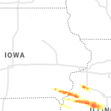
Hail Map for Wednesday, April 8, 2020

Number of Impacted Households on 4/8/2020
0
Impacted by 1" or Larger Hail
0
Impacted by 1.75" or Larger Hail
0
Impacted by 2.5" or Larger Hail
Square Miles of Populated Area Impacted on 4/8/2020
0
Impacted by 1" or Larger Hail
0
Impacted by 1.75" or Larger Hail
0
Impacted by 2.5" or Larger Hail


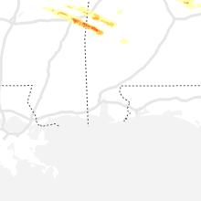
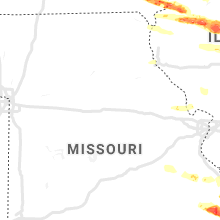


Cities Most Affected by Hail Storms of 4/8/2020
| Hail Size | Demographics of Zip Codes Affected | ||||||
|---|---|---|---|---|---|---|---|
| City | Count | Average | Largest | Pop Density | House Value | Income | Age |
| West Point, IA | 3 | 2.50 | 4.00 | 23 | $83k | $45.0k | 47.0 |
| Meridian, MS | 3 | 2.33 | 2.75 | 128 | $54k | $24.5k | 35.3 |
| Sikeston, MO | 2 | 2.25 | 2.25 | 114 | $75k | $29.9k | 39.3 |
| Eclectic, AL | 2 | 1.88 | 2.00 | 68 | $96k | $36.9k | 43.8 |
| Horseshoe Bend, AR | 2 | 1.75 | 1.75 | 106 | $65k | $26.6k | 59.3 |
| West Plains, MO | 2 | 1.75 | 1.75 | 54 | $73k | $27.3k | 39.0 |
| Mount Orab, OH | 2 | 1.75 | 1.75 | 147 | $91k | $40.4k | 36.6 |
| Thayer, MO | 2 | 1.75 | 1.75 | 33 | $53k | $21.9k | 44.3 |
| Strawberry, AR | 1 | 2.75 | 2.75 | 12 | $48k | $26.3k | 41.8 |
| Oak Hill, OH | 1 | 2.50 | 2.50 | 55 | $58k | $27.0k | 37.9 |
| Rector, AR | 1 | 2.00 | 2.00 | 21 | $37k | $26.2k | 42.3 |
| Bonnieville, KY | 1 | 1.75 | 1.75 | 40 | $55k | $26.4k | 41.6 |
| Zalma, MO | 1 | 1.75 | 1.75 | 12 | $52k | $22.3k | 44.9 |
| Vinton, OH | 1 | 1.75 | 1.75 | 36 | $61k | $28.1k | 40.2 |
| Sardinia, OH | 1 | 1.75 | 1.75 | 83 | $91k | $38.5k | 39.9 |
| Hillsboro, OH | 1 | 1.75 | 1.75 | 78 | $87k | $33.6k | 40.6 |
| Butler, AL | 1 | 1.75 | 1.75 | 18 | $64k | $27.8k | 44.9 |
| Ravenden, AR | 1 | 1.75 | 1.75 | 12 | $40k | $24.1k | 47.4 |
| Leachville, AR | 1 | 1.75 | 1.75 | 29 | $42k | $29.2k | 35.6 |
| Salem, IA | 1 | 1.75 | 1.75 | 16 | $51k | $40.7k | 44.5 |
| Macomb, IL | 1 | 1.75 | 1.75 | 106 | $73k | $29.2k | 24.3 |
| Little Rock, MS | 1 | 1.75 | 1.75 | 30 | $52k | $31.0k | 41.9 |
| Westpoint, TN | 1 | 1.75 | 1.75 | 15 | $56k | $28.5k | 42.1 |
| Greenville, MO | 1 | 1.75 | 1.75 | 8 | $39k | $24.5k | 46.6 |
| Glenallen, MO | 1 | 1.75 | 1.75 | 12 | $61k | $25.0k | 42.9 |
| South Webster, OH | 1 | 1.75 | 1.75 | 34 | $60k | $32.2k | 40.6 |
| Lynn, AR | 1 | 1.75 | 1.75 | 9 | $43k | $25.2k | 40.1 |
| Waterloo, AL | 1 | 1.75 | 1.75 | 20 | $61k | $26.3k | 41.9 |
| Ghent, KY | 1 | 1.75 | 1.75 | 28 | $81k | $53.3k | 38.1 |
| Mowrystown, OH | 1 | 1.75 | 1.75 | 0 | $64k | $37.4k | 34.8 |
Hail and Wind Damage Spotted on 4/8/2020
Filter by Report Type:Hail ReportsWind Reports
States Impacted
West Virginia, Kentucky, Ohio, Pennsylvania, Maryland, Indiana, Arkansas, Mississippi, Iowa, Alabama, Virginia, Illinois, Georgia, Tennessee, North Carolina, MissouriWest Virginia
| Local Time | Report Details |
|---|---|
| 9:18 AM EDT | Tree down in elkview in kanawha county WV, 10.7 miles ENE of Charleston, WV |
| 9:18 AM EDT | Tree down in pinch. time estimated from radar. lsr corrected for location in kanawha county WV, 9.6 miles ENE of Charleston, WV |
| 9:18 AM EDT | Tree down in pinch. time estimated from radar in kanawha county WV, 7.7 miles E of Charleston, WV |
| 12:30 PM EDT | Quarter sized hail reported near Scott Depot, WV, 15.3 miles WNW of Charleston, WV, hail fell from 12:20 to 12:35. mainly pea to dime size... but had a bit of quarter size mixed in starting around 12:30. |
| 12:35 PM EDT | Quarter sized hail reported near Hurricane, WV, 18.2 miles WNW of Charleston, WV |
| 12:35 PM EDT | Half Dollar sized hail reported near Hurricane, WV, 19.2 miles WNW of Charleston, WV, nws employee 2 miles west of teays valley |
| 12:41 PM EDT | Quarter sized hail reported near Saint Albans, WV, 11.3 miles WNW of Charleston, WV |
| 1:30 PM EDT | Trees and logs blocking both lanes of smith creek road in kanawha county WV, 12.1 miles W of Charleston, WV |
| 2:08 PM EDT | Half Dollar sized hail reported near Glen Jean, WV, 39.4 miles SE of Charleston, WV, time estimated from radar |
| 2:20 PM EDT | Half Dollar sized hail reported near Oak Hill, WV, 38.7 miles SE of Charleston, WV, report from dhsem regional liaison. |
| 3:04 PM EDT | Wind gust measured on rooftop weather station. tree limb fell through the roof of an unoccupied car nearby. also... quarter sized hail was observe in boone county WV, 22.3 miles SSW of Charleston, WV |
| 3:10 PM EDT | Quarter sized hail reported near Ballard, WV, 47.2 miles WNW of Roanoke, VA |
| 3:15 PM EDT | Quarter sized hail reported near Lindside, WV, 42.7 miles WNW of Roanoke, VA |
| 3:18 PM EDT | Quarter sized hail reported near Lindside, WV, 42.7 miles WNW of Roanoke, VA, corrects previous hail report from 1 nw lindside. |
| 3:18 PM EDT | Half Dollar sized hail reported near Lindside, WV, 42.1 miles WNW of Roanoke, VA, hail up to the size of half dollars covering the ground. |
| 3:19 PM EDT | Camper overturned in lindsid in monroe county WV, 42.2 miles WNW of Roanoke, VA |
| 3:33 PM EDT | Tree fell through a house. also small hail of unknown size. em took information from publi in mingo county WV, 52 miles SW of Charleston, WV |
| 3:58 PM EDT | Quarter sized hail reported near Ghent, WV, 58.1 miles SSE of Charleston, WV, reported blowing hail and that hail was covering the ground. |
| 4:20 PM EDT | Large tree down on mercer springs r in mercer county WV, 60.3 miles W of Roanoke, VA |
| 4:25 PM EDT | Tree down on red sulphur turnpik in mercer county WV, 59.9 miles W of Roanoke, VA |
| 4:37 PM EDT | Quarter sized hail reported near Peterstown, WV, 45.2 miles W of Roanoke, VA, quarter size hail reported near ripplemead. |
| 4:40 PM EDT | Some trees are down and broken with power outages in the welch... avondale... and gary communities. one house damaged from a tree falling on it in gar in mcdowell county WV, 65.6 miles NE of Bristol, TN |
| 12:39 AM EDT | Tree limbs less than 4 inches and at least one power pole broke in cabell county WV, 42.7 miles W of Charleston, WV |
| 12:48 AM EDT | Quarter sized hail reported near Milton, WV, 27.6 miles WNW of Charleston, WV, lasted about 3 minutes. |
| 12:52 AM EDT | Quarter sized hail reported near Ashton, WV, 27.9 miles WNW of Charleston, WV |
| 12:58 AM EDT | Spotter has anemomete in putnam county WV, 25.7 miles NW of Charleston, WV |
| 12:58 AM EDT | Quarter sized hail reported near Buffalo, WV, 25.7 miles NW of Charleston, WV, quarter size hail. |
| 1:00 AM EDT | 8-10 homes damaged/roofs destroyed between hurricane and teays valle in putnam county WV, 20.6 miles WNW of Charleston, WV |
| 1:04 AM EDT | Approximately 50 ft of a 180 ft communications tower knocked ove in putnam county WV, 14.6 miles WNW of Charleston, WV |
| 1:04 AM EDT | Swing set tossed into yard from neighbor's yar in putnam county WV, 21.6 miles WNW of Charleston, WV |
| 1:07 AM EDT | Roof blown off house in libert in putnam county WV, 17.9 miles NNW of Charleston, WV |
| 1:08 AM EDT | A 180 foot radio tower was blown over. the moses fiat building collapsed. saint albans window... a business... had their roof blown of in kanawha county WV, 11.3 miles WNW of Charleston, WV |
| 1:15 AM EDT | Down tree on winfield roa in putnam county WV, 18.8 miles NW of Charleston, WV |
| 1:31 AM EDT | 2 trees down on clay roa in roane county WV, 33.4 miles NE of Charleston, WV |
| 1:49 AM EDT | Tree dow in nicholas county WV, 25.4 miles ESE of Charleston, WV |
| 2:35 AM EDT | 1 tree down on shelby roa in upshur county WV, 24.8 miles WSW of Elkins, WV |
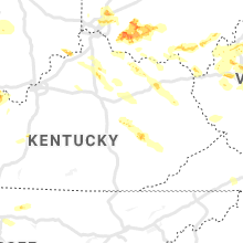
Kentucky
| Local Time | Report Details |
|---|---|
| 10:44 AM EDT | Numerous trees and power lines down. time estimated from rada in grant county KY, 28.3 miles SSW of Cincinnati, OH |
| 1:05 PM EDT | Golf Ball sized hail reported near Ghent, KY, 39.2 miles SW of Cincinnati, OH, quarter to near golf ball sized hail. time estimated by radar. |
| 1:43 PM EDT | Tree blocking turner r in fleming county KY, 58.9 miles NNE of Irvine, KY |
| 1:45 PM EDT | Quarter sized hail reported near Wallingford, KY, 52.6 miles NNE of Irvine, KY, quarter size hail located approximately 10 miles due east of flemingsburg. |
| 1:45 PM EDT | Quarter sized hail reported near Wallingford, KY, 54.5 miles NNE of Irvine, KY, corrects previous 1 inch hail report 2 nw muses mills. |
| 1:47 PM EDT | Half Dollar sized hail reported near Owenton, KY, 39.5 miles SSW of Cincinnati, OH, time estimated from radar |
| 2:13 PM EDT | Trees down and debris viewed from i-64 near mile marker 14 in rowan county KY, 50 miles NE of Irvine, KY |
| 4:15 PM EDT | Tree snapped about 2 feet from the base. report via social medi in floyd county KY, 69.2 miles NNW of Bristol, TN |
| 4:30 PM EDT | Tree down in jackso in breathitt county KY, 34.2 miles ESE of Irvine, KY |
| 5:41 PM EDT | Quarter sized hail reported near Irvine, KY, 3 miles W of Irvine, KY, report from mping: quarter (1.00 in.). |
| 5:43 PM EDT | Quarter sized hail reported near Irvine, KY, 0.3 miles E of Irvine, KY, social media report of quarter size hail. |
| 5:14 PM CDT | Golf Ball sized hail reported near Bonnieville, KY, 40.3 miles SSW of Louisville, KY |
| 5:15 PM CDT | Quarter sized hail reported near Bonnieville, KY, 39.6 miles SSW of Louisville, KY, former nws employee report. |
| 7:09 PM CDT | Half Dollar sized hail reported near Bardwell, KY, 42 miles SE of Cape Girardeau, MO |
| 7:43 PM CDT | Quarter sized hail reported near Mayfield, KY, 39.6 miles N of Mc Kenzie, TN, report from mping: quarter (1.00 in.). |
| 8:00 PM CDT | Quarter sized hail reported near Murray, KY, 31.8 miles N of Mc Kenzie, TN, report from mping: quarter (1.00 in.). |
| 8:07 PM CDT | Quarter sized hail reported near Murray, KY, 34.7 miles NNE of Mc Kenzie, TN |
| 8:08 PM CDT | Quarter sized hail reported near Princeton, KY, 62.3 miles SSW of Evansville, IN |
| 8:18 PM CDT | Ping Pong Ball sized hail reported near Murray, KY, 33.9 miles NNE of Mc Kenzie, TN |
| 8:25 PM CDT | Quarter sized hail reported near Murray, KY, 32.4 miles NNE of Mc Kenzie, TN, report from mping: quarter (1.00 in.). |
| 8:35 PM CDT | Quarter sized hail reported near Hopkinsville, KY, 61.5 miles NW of Nashville, TN |
| 9:00 PM CDT | Power poles snapped on swann lane in robards. time estimate in henderson county KY, 20.5 miles S of Evansville, IN |
| 9:00 PM CDT | Tree down on highway 266 west of corydon. time estimate in henderson county KY, 17.6 miles SSW of Evansville, IN |
| 9:05 PM CDT | Mesonet station zion elkton 5 s in todd county KY, 47.4 miles NNW of Nashville, TN |
| 9:05 PM CDT | Part of a barn blown onto a road. time estimate in todd county KY, 47.1 miles NNW of Nashville, TN |
| 10:28 PM EDT | Storm damage reported in boone county KY, 9.2 miles WSW of Cincinnati, OH |
| 10:32 PM EDT | Large tree limbs downed. time estimated by rada in boone county KY, 10.9 miles SW of Cincinnati, OH |
| 10:35 PM EDT | Large tree downed on a house. time estimated by rada in kenton county KY, 4.9 miles SW of Cincinnati, OH |
| 10:35 PM EDT | Large tree downed in ludlow. time estimated by rada in kenton county KY, 2.7 miles WSW of Cincinnati, OH |
| 10:39 PM EDT | Multiple trees snapped. part of barn blown onto road. trees blocking road. corrected time of event based on rada in kenton county KY, 21.2 miles SSW of Cincinnati, OH |
| 10:39 PM EDT | Large tree downed onto a vehicle. time estimated by rada in kenton county KY, 9.4 miles S of Cincinnati, OH |
| 10:40 PM EDT | Severe damage to a house... with an entire side removed. large trees snapped along vallandingham rd. time estimated by rada in grant county KY, 28 miles SSW of Cincinnati, OH |
| 10:40 PM EDT | Shattered window and roof damage. multiple trees down as wel in oldham county KY, 30.1 miles NNE of Louisville, KY |
| 10:40 PM EDT | Tree and powerlines downed along courtney rd. time estimated by rada in kenton county KY, 21.2 miles SSW of Cincinnati, OH |
| 10:42 PM EDT | Tree damage in lexington trails subdivision. time estimated by rada in grant county KY, 28.1 miles SSW of Cincinnati, OH |
| 10:43 PM EDT | Quarter sized hail reported near Fort Thomas, KY, 3.5 miles ESE of Cincinnati, OH, 2-inch tree limbs down as well |
| 9:43 PM CDT | No power in the gold city and hickory flats area of simpson count in simpson county KY, 44.1 miles NNE of Nashville, TN |
| 10:43 PM EDT | Numerous trees down with 6-inch trunks. corrected time of event based on rada in campbell county KY, 12.1 miles SSE of Cincinnati, OH |
| 10:44 PM EDT | Numerous trees and power lines down. time estimated from rada in grant county KY, 28.3 miles SSW of Cincinnati, OH |
| 10:55 PM EDT | Quarter sized hail reported near Payneville, KY, 39.2 miles W of Louisville, KY |
| 11:00 PM EDT | Kentucky mesonet station cro in shelby county KY, 38.4 miles NE of Louisville, KY |
| 10:00 PM CDT | Mesonet station 0683w 1.0 nw bowling green (weatherstem in warren county KY, 59.6 miles NNE of Nashville, TN |
| 11:05 PM EDT | Several trees downed along courts hill road. time of event estimate in bracken county KY, 31.9 miles SE of Cincinnati, OH |
| 11:05 PM EDT | At least partial roof removal from salem church. time of event estimated by rada in bracken county KY, 32.2 miles SE of Cincinnati, OH |
| 11:07 PM EDT | Trees downed along walcott-johnsville road. time estimated by rada in bracken county KY, 32.5 miles SE of Cincinnati, OH |
| 11:11 PM EDT | Numerous trees and structures down between berlin and brooksville north to the aa highway. time estimated from radar in bracken county KY, 34.7 miles SE of Cincinnati, OH |
| 11:12 PM EDT | Numerous trees down with 6-inch trunk in campbell county KY, 12.1 miles SSE of Cincinnati, OH |
| 11:17 PM EDT | Earlywine racing facility sustained damage. time estimated by rada in mason county KY, 42.3 miles SE of Cincinnati, OH |
| 11:19 PM EDT | Multiple trees snapped. part of barn blown onto road. trees blocking road. time is when spotter calle in kenton county KY, 21.2 miles SSW of Cincinnati, OH |
| 11:22 PM EDT | Barn destroyed in sardis. time estimated by rada in mason county KY, 49.5 miles SE of Cincinnati, OH |
| 11:25 PM EDT | Roof partially removed from a house. time estimated by rada in mason county KY, 49.8 miles SE of Cincinnati, OH |
| 11:25 PM EDT | Wind blew over 20 foot steel cargo container 4 miles north of flemingsburg on hwy 57. report received via social medi in fleming county KY, 54.8 miles NNE of Irvine, KY |
| 11:26 PM EDT | Tree downed on wintu circle in maysville. time estimated by rada in mason county KY, 50.2 miles SE of Cincinnati, OH |
| 11:28 PM EDT | Large tree downed through a house. time estimated by rada in mason county KY, 52.7 miles SE of Cincinnati, OH |
| 11:28 PM EDT | Trees downed along us 68 near mays lick. time estimated by rada in mason county KY, 53.6 miles SE of Cincinnati, OH |
| 11:35 PM EDT | Storm damage reported in mason county KY, 56.8 miles SE of Cincinnati, OH |
| 11:40 PM EDT | Severely damaged home along manley hollow road. several trees snapped. time estimated by rada in lewis county KY, 63.3 miles ESE of Cincinnati, OH |
| 12:00 AM EDT | Ky-799 closed at i-64 crossing due to multiple downed trees and power line in rowan county KY, 51 miles NE of Irvine, KY |
| 12:05 AM EDT | Tree down across roa in greenup county KY, 76 miles WNW of Charleston, WV |
| 12:05 AM EDT | 911 call center indicated fallen tree over one lane of us-60 near the montgomery/bath county lin in bath county KY, 30.1 miles N of Irvine, KY |
| 12:11 AM EDT | Broadcast media relayed a video of a tree down near danville. time estimate off rada in boyle county KY, 43.8 miles W of Irvine, KY |
| 12:17 AM EDT | Power outages reported. winds estimated at up to 70 mp in mercer county KY, 46.7 miles WNW of Irvine, KY |
| 12:20 AM EDT | Tree down across roa in greenup county KY, 58.6 miles W of Charleston, WV |
| 12:28 AM EDT | Report of power outages in the wilgreen lake are in madison county KY, 21.1 miles W of Irvine, KY |
| 12:30 AM EDT | Quarter sized hail reported near Crab Orchard, KY, 33.7 miles WSW of Irvine, KY, broadcast media relayed a public picture of quarter sized hail. |
| 12:35 AM EDT | Multiple trees down and electrical box torn off side of home in broadhead are in rockcastle county KY, 31.6 miles SW of Irvine, KY |
| 12:46 AM EDT | Quarter sized hail reported near Mount Vernon, KY, 33.6 miles SW of Irvine, KY |
| 12:55 AM EDT | Trees down and pea-sized hai in magoffin county KY, 49.6 miles E of Irvine, KY |
| 1:00 AM EDT | Numerous trees down in gray hawk / mckee are in jackson county KY, 19.3 miles S of Irvine, KY |
| 1:05 AM EDT | Shingles blown off home and roof blown off of outbuilding near intersection of bank cemetery rd. and kelly r in jackson county KY, 20.8 miles S of Irvine, KY |
| 1:45 AM EDT | Pine tree blocking wendover r in leslie county KY, 50.1 miles SE of Irvine, KY |
| 2:12 AM EDT | Tree fell on power line and house on wood st. in cumberland... ky. report received via social medi in harlan county KY, 50.3 miles WNW of Bristol, TN |
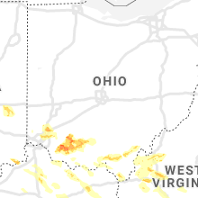
Ohio
| Local Time | Report Details |
|---|---|
| 10:45 AM EDT | Numerous trees snapped on buckingham lane. time estimated from rada in clermont county OH, 15.7 miles ENE of Cincinnati, OH |
| 10:04 PM EDT | Quarter sized hail reported near Bethel, OH, 25.5 miles ESE of Cincinnati, OH |
| 10:04 PM EDT | Half Dollar sized hail reported near Middletown, OH, 20.2 miles NNE of Cincinnati, OH, time estimated by radar. |
| 10:05 PM EDT | Ping Pong Ball sized hail reported near Bethel, OH, 25 miles ESE of Cincinnati, OH, time estimated by radar. |
| 10:06 PM EDT | Quarter sized hail reported near Monroe, OH, 24.3 miles NNE of Cincinnati, OH |
| 10:07 PM EDT | Ping Pong Ball sized hail reported near Mason, OH, 20.4 miles NNE of Cincinnati, OH |
| 10:09 PM EDT | Quarter sized hail reported near Mason, OH, 20.4 miles NNE of Cincinnati, OH, time estimated by radar. |
| 10:11 PM EDT | Quarter sized hail reported near Mason, OH, 20.4 miles NNE of Cincinnati, OH |
| 10:12 PM EDT | Quarter sized hail reported near Williamsburg, OH, 24.8 miles E of Cincinnati, OH, time estimated by radar. |
| 10:12 PM EDT | Ping Pong Ball sized hail reported near Williamsburg, OH, 24.8 miles E of Cincinnati, OH, numerous reports/pictures from williamsburg of hail ranging from half dollar to ping pongs. time estimated by radar. |
| 10:15 PM EDT | Quarter sized hail reported near Cincinnati, OH, 12.7 miles N of Cincinnati, OH, time estimated by radar. |
| 10:15 PM EDT | Golf Ball sized hail reported near Mount Orab, OH, 31.9 miles E of Cincinnati, OH, time estimated by radar. |
| 10:18 PM EDT | Ping Pong Ball sized hail reported near Cincinnati, OH, 11.9 miles NE of Cincinnati, OH, time estimated by radar. |
| 10:19 PM EDT | Trees/powerlines/debris downed on us-50 at lawrenceville road. time estimated by rada in hamilton county OH, 16.8 miles WNW of Cincinnati, OH |
| 10:19 PM EDT | Half Dollar sized hail reported near Cincinnati, OH, 10.2 miles NNE of Cincinnati, OH |
| 10:21 PM EDT | Tree downed near nortgate mall. time estimated by rada in hamilton county OH, 10.3 miles NNW of Cincinnati, OH |
| 10:22 PM EDT | Quarter sized hail reported near Cincinnati, OH, 11.9 miles NE of Cincinnati, OH |
| 10:23 PM EDT | Shingles removed from a roof. time estimated by rada in butler county OH, 15.5 miles N of Cincinnati, OH |
| 10:25 PM EDT | Quarter sized hail reported near Loveland, OH, 16.9 miles NE of Cincinnati, OH |
| 10:25 PM EDT | Quarter sized hail reported near Hamilton, OH, 20.5 miles N of Cincinnati, OH |
| 10:25 PM EDT | Quarter sized hail reported near Cincinnati, OH, 12.9 miles NE of Cincinnati, OH |
| 10:25 PM EDT | Quarter sized hail reported near Sardinia, OH, 35.8 miles E of Cincinnati, OH, time estimated by radar |
| 10:25 PM EDT | Trees downed... storefront window broken along hamilton ave in mount healthy. time estimated by rada in hamilton county OH, 8.9 miles NNW of Cincinnati, OH |
| 10:26 PM EDT | Large tree downed along shamrock ave in north college hill. time estimated by rada in hamilton county OH, 8.1 miles NNW of Cincinnati, OH |
| 10:26 PM EDT | Numerous trees down and pea-sized hail in hamilton county OH, 12.5 miles NNW of Cincinnati, OH |
| 10:27 PM EDT | Golf Ball sized hail reported near Mount Orab, OH, 31.9 miles E of Cincinnati, OH, photo posted on social media |
| 10:31 PM EDT | Golf Ball sized hail reported near Sardinia, OH, 37.9 miles E of Cincinnati, OH, time estimated by radar. |
| 10:32 PM EDT | Tree downed along vine street. time estimated by rada in hamilton county OH, 3.7 miles N of Cincinnati, OH |
| 10:32 PM EDT | Quarter sized hail reported near Maineville, OH, 18.5 miles NE of Cincinnati, OH |
| 10:33 PM EDT | Large tree downed. time estimated by rada in hamilton county OH, 7.6 miles NNE of Cincinnati, OH |
| 10:33 PM EDT | Large tree uprooted in silverton. time estimated by rada in hamilton county OH, 8 miles NE of Cincinnati, OH |
| 10:35 PM EDT | Large tree downed. time estimated by rada in hamilton county OH, 10.2 miles NE of Cincinnati, OH |
| 10:36 PM EDT | Golf Ball sized hail reported near Mowrystown, OH, 40.8 miles E of Cincinnati, OH, time estimated by radar. |
| 10:38 PM EDT | Siding removed from a house. time estimated by rada in hamilton county OH, 6.1 miles ENE of Cincinnati, OH |
| 10:40 PM EDT | Multiple reports of trees dow in clermont county OH, 15.6 miles ENE of Cincinnati, OH |
| 10:41 PM EDT | Ping Pong Ball sized hail reported near Hillsboro, OH, 48.5 miles E of Cincinnati, OH, time estimated by radar. |
| 10:42 PM EDT | Trees downed... storefront window broken along hamilton ave in mount healthy. time estimated by rada in hamilton county OH, 8.9 miles NNW of Cincinnati, OH |
| 10:43 PM EDT | Trees and powerlines downed with debris on sr-131 between dry run road and betty road. time estimated by rada in clermont county OH, 15.6 miles ENE of Cincinnati, OH |
| 10:45 PM EDT | Numerous trees snapped on buckingham lane. time estimated from rada in clermont county OH, 15.7 miles ENE of Cincinnati, OH |
| 10:45 PM EDT | Siding ripped off... flagpole down... numerous trees down on caribou run lane. time estimated from rada in clermont county OH, 16.4 miles ENE of Cincinnati, OH |
| 10:46 PM EDT | Multiple trees downed in road in stonelick township on wild rose lane. time estimated by rada in clermont county OH, 18 miles ENE of Cincinnati, OH |
| 10:47 PM EDT | Half Dollar sized hail reported near Hillsboro, OH, 44.9 miles E of Cincinnati, OH, time estimated by radar. |
| 10:47 PM EDT | Multiple reports of trees down. time estimated by rada in clermont county OH, 20.9 miles ENE of Cincinnati, OH |
| 10:47 PM EDT | Multiple reports of trees down. time estimated by rada in clermont county OH, 20.9 miles ENE of Cincinnati, OH |
| 10:50 PM EDT | Numerous houses damaged around lake lorelei. time estimated from rada in brown county OH, 29.2 miles E of Cincinnati, OH |
| 10:52 PM EDT | Large barn flattened in 3100 block on park road near intersection of rte 131 and rte 133. wooden plank driven into side of structur in clermont county OH, 24.4 miles ENE of Cincinnati, OH |
| 10:53 PM EDT | Downed trees/powerlines on us-50 at bucktown road. time of event estimate in clermont county OH, 24.5 miles E of Cincinnati, OH |
| 10:53 PM EDT | Golf Ball sized hail reported near Hillsboro, OH, 44.9 miles E of Cincinnati, OH, photo posted on social media. |
| 10:54 PM EDT | Many trees down in hamilton county OH, 8 miles NE of Cincinnati, OH |
| 10:55 PM EDT | Multiple reports of trees down. time estimated by rada in clermont county OH, 20.4 miles SE of Cincinnati, OH |
| 10:56 PM EDT | State rte 222 closed in both directions beetween bethel-hygiene road and saltair-maple road. time estimated by rada in clermont county OH, 23.5 miles ESE of Cincinnati, OH |
| 10:59 PM EDT | Multiple reports of trees down. time estimated by rada in clermont county OH, 25.6 miles ESE of Cincinnati, OH |
| 11:01 PM EDT | Sheet metal removed from a structure in blanchester. time estimated by rada in clinton county OH, 30.9 miles ENE of Cincinnati, OH |
| 11:03 PM EDT | Numerous trees down and pole barns down on sr-123 between curless and denman road. time estimated from rada in clinton county OH, 31.6 miles ENE of Cincinnati, OH |
| 11:05 PM EDT | Trees and power lines down in hamersville area. time estimated from rada in brown county OH, 30.5 miles ESE of Cincinnati, OH |
| 11:18 PM EDT | Golf Ball sized hail reported near South Webster, OH, 71.2 miles WNW of Charleston, WV, time estimated by radar. |
| 11:26 PM EDT | Several reports of damage throughout the aberdeen area. trees uprooted... roof damage. time estimated from rada in brown county OH, 49.8 miles SE of Cincinnati, OH |
| 11:27 PM EDT | Half Dollar sized hail reported near Jackson, OH, 66 miles SSE of Columbus, OH, hail bigger than a quarter along with heavy rain and frequent lightning... but not much wind. sound of hailstones hitting car diminished during call. |
| 11:36 PM EDT | Quarter sized hail reported near Oak Hill, OH, 63.6 miles NW of Charleston, WV, pea to quarter size hail. |
| 12:04 AM EDT | Half Dollar sized hail reported near Portsmouth, OH, 74.5 miles WNW of Charleston, WV, time estimated by radar. |
| 12:06 AM EDT | Golf Ball sized hail reported near Vinton, OH, 57.7 miles NW of Charleston, WV |
| 12:19 AM EDT | Tennis Ball sized hail reported near Oak Hill, OH, 63.1 miles NW of Charleston, WV |
| 12:21 AM EDT | One large tree down on depue r in vinton county OH, 57.8 miles SSE of Columbus, OH |
| 12:26 AM EDT | Several mobile homes moved off foundations/damaged. several garages destroyed. numerous trees down. damaged occurred along covered bridge r in vinton county OH, 63.8 miles NW of Charleston, WV |
| 12:49 AM EDT | Down tree taking out power lines along pomeroy pik in meigs county OH, 52.8 miles NNW of Charleston, WV |
Pennsylvania
| Local Time | Report Details |
|---|---|
| 12:07 PM EDT | Several trees knocked down in davidsvill in somerset county PA, 57.7 miles ESE of Pittsburgh, PA |
| 12:39 PM EDT | 834 cresent ave pine tree fell on residence and vehicle. no injuries reporte in lawrence county PA, 32.7 miles NNW of Pittsburgh, PA |
Maryland
| Local Time | Report Details |
|---|---|
| 12:59 PM EDT | Quarter sized hail reported near Bel Air, MD, 24.6 miles NE of Baltimore, MD, quarter size hail |
Indiana
| Local Time | Report Details |
|---|---|
| 1:03 PM EDT | Quarter sized hail reported near Vevay, IN, 39.2 miles SW of Cincinnati, OH |
| 1:05 PM EDT | Half Dollar sized hail reported near Vevay, IN, 39.2 miles SW of Cincinnati, OH |
| 7:05 PM EDT | Quarter sized hail reported near Williamsport, IN, 70.4 miles WNW of Indianapolis, IN, twitter reports of hail accumulation on grassy surfaces from 7:05-7:15 pm edt. |
| 7:15 PM EDT | Quarter sized hail reported near West Lebanon, IN, 74.2 miles WNW of Indianapolis, IN, twitter report. |
| 7:32 PM EDT | Quarter sized hail reported near Wingate, IN, 56.2 miles WNW of Indianapolis, IN, picture receieved via facebook. time estimated from radar. |
| 7:35 PM EDT | Large tree over driveway. relayed via medi in tippecanoe county IN, 64.1 miles NW of Indianapolis, IN |
| 8:08 PM EDT | Quarter sized hail reported near Thorntown, IN, 35 miles NW of Indianapolis, IN |
| 8:14 PM EDT | Power outage in vigo county IN, 54.5 miles E of Mattoon, IL |
| 8:15 PM EDT | Multiple power poles dow in vermillion county IN, 51 miles ENE of Mattoon, IL |
| 8:15 PM EDT | Twitter report and picture of trees and power lines dow in vermillion county IN, 53.5 miles ENE of Mattoon, IL |
| 8:22 PM EDT | Corrects timing on previous tstm wnd gst report from 1 ese greencastle. awos station kgpc greencastl in putnam county IN, 36.9 miles WSW of Indianapolis, IN |
| 8:25 PM EDT | Report from mping: 3-inch tree limbs broken; power poles broke in vigo county IN, 55 miles E of Mattoon, IL |
| 8:28 PM EDT | Report from mping: 3-inch tree limbs broken; power poles broke in boone county IN, 24.9 miles NW of Indianapolis, IN |
| 8:28 PM EDT | Report from mping: 1-inch tree limbs broken; shingles blown of in boone county IN, 33.9 miles NW of Indianapolis, IN |
| 8:30 PM EDT | Quarter sized hail reported near Carmel, IN, 16.3 miles N of Indianapolis, IN |
| 8:33 PM EDT | Storm damage reported in vigo county IN, 54.5 miles E of Mattoon, IL |
| 8:35 PM EDT | Awos station kgpc greencastl in putnam county IN, 36.9 miles WSW of Indianapolis, IN |
| 8:38 PM EDT | Report from mping: 1-inch tree limbs broken; shingles blown of in hendricks county IN, 14.4 miles WSW of Indianapolis, IN |
| 8:39 PM EDT | Power lines down near 171st st and sr3 in hamilton county IN, 18.2 miles N of Indianapolis, IN |
| 8:42 PM EDT | Twitter report with pictures of the top floor of a business destroyed in downtown mooresville. time estimated from rada in morgan county IN, 15.5 miles SW of Indianapolis, IN |
| 8:44 PM EDT | Storm damage reported in marion county IN, 2.6 miles SSW of Indianapolis, IN |
| 8:45 PM EDT | Possible tornado. corrects previous tornado report from 4 ne camby. observed from mann rd and mills in 46221. looking mostly west and slightly north. it threw my daught in marion county IN, 8.5 miles SW of Indianapolis, IN |
| 8:46 PM EDT | Storm damage reported in marion county IN, 7.9 miles WSW of Indianapolis, IN |
| 8:48 PM EDT | A tree landed on a house just east of hague road in between 75th and 71st streets. twitter repor in marion county IN, 10.6 miles NE of Indianapolis, IN |
| 8:50 PM EDT | Report from mping: 1-inch tree limbs broken; shingles blown off... radar estimated tim in marion county IN, 5.6 miles ENE of Indianapolis, IN |
| 8:50 PM EDT | Report from mping: 1-inch tree limbs broken; shingles blown of in morgan county IN, 24.4 miles SSW of Indianapolis, IN |
| 8:56 PM EDT | Storm damage reported in greene county IN, 72 miles ESE of Mattoon, IL |
| 8:56 PM EDT | Storm damage reported in hancock county IN, 14 miles ENE of Indianapolis, IN |
| 8:59 PM EDT | Power flashes near 6th s in knox county IN, 49.3 miles N of Evansville, IN |
| 8:59 PM EDT | Report from mping: 3-inch tree limbs broken; power poles broke in vigo county IN, 46.6 miles ENE of Mattoon, IL |
| 9:02 PM EDT | Power outages all over central and southern madison count in madison county IN, 33.5 miles NE of Indianapolis, IN |
| 9:05 PM EDT | Guyed tower with a small wind turbine at a private residence collapsed. (no injuries). shingles torn from roo in hancock county IN, 24.8 miles E of Indianapolis, IN |
| 9:05 PM EDT | Twitter picture of roof damage to jefferson st pu in johnson county IN, 20.5 miles SSE of Indianapolis, IN |
| 9:06 PM EDT | Report from mping: 1-inch tree limbs broken; shingles blown of in hancock county IN, 18.7 miles E of Indianapolis, IN |
| 9:09 PM EDT | Storm damage reported in knox county IN, 57.1 miles NNE of Evansville, IN |
| 9:09 PM EDT | Semi blown off roa in knox county IN, 46.5 miles N of Evansville, IN |
| 9:09 PM EDT | Trees down. possible tornado. corrects previous tornado report from mccormicks creek state par in owen county IN, 46.3 miles SW of Indianapolis, IN |
| 9:10 PM EDT | Twitter report and picture of a tree on a ca in henry county IN, 33.1 miles E of Indianapolis, IN |
| 9:10 PM EDT | Twitter report and picture of a tree falling on house and damaging the roof and chimne in hancock county IN, 20.4 miles E of Indianapolis, IN |
| 9:11 PM EDT | Report from mping: 1-inch tree limbs broken; shingles blown of in marion county IN, 8.9 miles S of Indianapolis, IN |
| 9:13 PM EDT | Report from mping: trees uprooted or snapped; roof blown of in marion county IN, 8 miles SW of Indianapolis, IN |
| 9:15 PM EDT | Report from mping: 1-inch tree limbs broken; shingles blown of in johnson county IN, 15 miles S of Indianapolis, IN |
| 9:15 PM EDT | Report from mping: trees uprooted or snapped; roof blown of in pike county IN, 39.5 miles NNE of Evansville, IN |
| 9:16 PM EDT | Storm damage reported in johnson county IN, 29.7 miles SSE of Indianapolis, IN |
| 9:16 PM EDT | Power lines down over sullivan count in sullivan county IN, 58.4 miles ESE of Mattoon, IL |
| 9:18 PM EDT | Quarter sized hail reported near Vincennes, IN, 51.3 miles N of Evansville, IN, report from mping: quarter (1.00 in.). |
| 9:18 PM EDT | Report from mping: 3-inch tree limbs broken; power poles broke in knox county IN, 51.3 miles N of Evansville, IN |
| 9:20 PM EDT | 2 inch diameter tree limbs down. time estimated from rada in delaware county IN, 55.1 miles ENE of Indianapolis, IN |
| 9:20 PM EDT | Report from mping: 1-inch tree limbs broken; shingles blown of in knox county IN, 63.1 miles NNE of Evansville, IN |
| 9:22 PM EDT | Storm damage reported in rush county IN, 38.8 miles ESE of Indianapolis, IN |
| 9:24 PM EDT | Report from mping: 1-inch tree limbs broken; shingles blown of in shelby county IN, 27.3 miles SE of Indianapolis, IN |
| 9:25 PM EDT | Part of roof blown off near cr850 n and south paddock r in johnson county IN, 12.4 miles S of Indianapolis, IN |
| 9:25 PM EDT | Three houses with significant damage and one business with roof damage. time estimated by rada in martin county IN, 60.1 miles NE of Evansville, IN |
| 9:25 PM EDT | Power flashes... sparks from pole outside propert in monroe county IN, 46.6 miles SSW of Indianapolis, IN |
| 9:27 PM EDT | Report from mping: 1-inch tree limbs broken; shingles blown of in johnson county IN, 30.5 miles SSE of Indianapolis, IN |
| 9:28 PM EDT | Multiple reports of structural and tree damage in various locations in vincenne in knox county IN, 48.6 miles N of Evansville, IN |
| 9:30 PM EDT | Trailer home rolled by wind. time estimated by rada in martin county IN, 63.7 miles NE of Evansville, IN |
| 9:34 PM EDT | Several small trees downed in the dalton area. time estimated by rada in wayne county IN, 53.6 miles ENE of Indianapolis, IN |
| 9:34 PM EDT | Multiple reports tree limbs down across the count in rush county IN, 38.7 miles ESE of Indianapolis, IN |
| 9:37 PM EDT | Half Dollar sized hail reported near Bloomington, IN, 46.6 miles SSW of Indianapolis, IN, will not appear in products. quarter to half dollar size hail with moderate ground coverage with second storm. |
| 9:38 PM EDT | Tree... over 12 inches in diameter... trunk snapped near perry crossin in hendricks county IN, 11.4 miles WSW of Indianapolis, IN |
| 9:40 PM EDT | Several large trees downed along state rte 1 south of connersville. time estimated by rada in fayette county IN, 44.3 miles NW of Cincinnati, OH |
| 9:40 PM EDT | Widespread wires downed and minor trees downed near cambridge city and west of milton. time estimated by rada in wayne county IN, 52.2 miles E of Indianapolis, IN |
| 9:43 PM EDT | Two large trees down on western avenue. roads are currently blocke in fayette county IN, 51.6 miles NW of Cincinnati, OH |
| 9:44 PM EDT | Report from mping: trees uprooted or snapped; roof blown of in hendricks county IN, 13.4 miles WSW of Indianapolis, IN |
| 9:45 PM EDT | House with half roof removed and barn with damage. time estimated from rada in decatur county IN, 50.2 miles SE of Indianapolis, IN |
| 9:46 PM EDT | Significant damage in fayetteville. power lines are down... roofs badly damaged... and large trees are down. metal chimney at the indian creek volunteer fire department in lawrence county IN, 66.9 miles SSW of Indianapolis, IN |
| 9:50 PM EDT | Widespread wires downed and minor trees downed near centerville. time estimated by rada in wayne county IN, 55.9 miles NNW of Cincinnati, OH |
| 9:53 PM EDT | Report from mping: 1-inch tree limbs broken; shingles blown of in marion county IN, 3.7 miles SE of Indianapolis, IN |
| 9:54 PM EDT | Power lines downed on 36th stree in dubois county IN, 45.3 miles NE of Evansville, IN |
| 9:55 PM EDT | Wind gust reported along sr 16 in dubois county IN, 48.2 miles NE of Evansville, IN |
| 9:57 PM EDT | Large trees downed along holland road. time estimated by rada in franklin county IN, 32.2 miles NW of Cincinnati, OH |
| 9:59 PM EDT | Report from mping: 3-inch tree limbs broken; power poles broke in hendricks county IN, 19.6 miles WSW of Indianapolis, IN |
| 10:00 PM EDT | Report from mping: 1-inch tree limbs broken; shingles blown of in johnson county IN, 11.3 miles SSW of Indianapolis, IN |
| 10:01 PM EDT | Telephone pole snapped in half. time estimated from rada in ripley county IN, 40.7 miles W of Cincinnati, OH |
| 10:13 PM EDT | Reports of tree damage and one house with a window blown out on ross roa in crawford county IN, 43.4 miles NW of Louisville, KY |
| 10:15 PM EDT | Multiple reports of tree damage and power lines down across orange count in washington county IN, 47.1 miles NNW of Louisville, KY |
| 10:15 PM EDT | Several trees down through the county... with specific damage centered around marengo. several power outages and lines down to in crawford county IN, 43 miles NW of Louisville, KY |
| 10:20 PM EDT | Milltown fire department measured a 76 mph wind gus in harrison county IN, 38.7 miles NW of Louisville, KY |
| 10:23 PM EDT | Storm damage reported in dearborn county IN, 19.1 miles W of Cincinnati, OH |
| 10:23 PM EDT | Roof damage to a garage on bethel ridge road. a few small trees downed. time estimated from rada in switzerland county IN, 31.5 miles SW of Cincinnati, OH |
| 10:25 PM EDT | Report from mping: 1-inch tree limbs broken; shingles blown of in hamilton county IN, 18.2 miles NE of Indianapolis, IN |
| 10:51 PM EDT | Report of a tree down on a house and dec in floyd county IN, 22.4 miles NNW of Louisville, KY |
Arkansas
| Local Time | Report Details |
|---|---|
| 12:15 PM CDT | Quarter sized hail reported near Eudora, AR, 44.1 miles ENE of Bastrop, LA, hail varying from pea size to at least quarter size in chicot county. |
| 5:31 PM CDT | Quarter sized hail reported near Salem, AR, 97.4 miles SSW of Salem, MO, quarter size hail reported south of viola in fulton county. time estimated from radar. |
| 5:55 PM CDT | Golf Ball sized hail reported near Horseshoe Bend, AR, 96.4 miles S of Salem, MO |
| 6:00 PM CDT | Golf Ball sized hail reported near Horseshoe Bend, AR, 98.4 miles S of Salem, MO, golf ball size hail reported in horshoe bend. |
| 6:30 PM CDT | Golf Ball sized hail reported near Ravenden, AR, 97.6 miles S of Salem, MO, golf ball size hail in ravenden. |
| 6:51 PM CDT | Baseball sized hail reported near Strawberry, AR, 91.2 miles NW of Memphis, TN, report relayed by nws memphis. |
| 6:53 PM CDT | Quarter sized hail reported near Strawberry, AR, 91.2 miles NW of Memphis, TN, report relayed by nws memphis. |
| 7:03 PM CDT | Golf Ball sized hail reported near Lynn, AR, 90 miles NW of Memphis, TN |
| 7:12 PM CDT | Quarter sized hail reported near Cash, AR, 73.5 miles NW of Memphis, TN, spotter report 1" hail |
| 8:01 PM CDT | Quarter sized hail reported near Jonesboro, AR, 58.1 miles NW of Memphis, TN, quarter size hail reported on the south side of jonesboro. |
| 8:15 PM CDT | Homes damaged and vehicles overturned in claypool are in poinsett county AR, 54.7 miles NW of Memphis, TN |
| 8:28 PM CDT | Homes west of the dollar general on highway 1 north of harrisburg were damaged by an apparent rear flank downdraf in poinsett county AR, 47.3 miles NW of Memphis, TN |
| 8:31 PM CDT | Quarter sized hail reported near Jonesboro, AR, 61 miles NW of Memphis, TN |
| 9:41 PM CDT | Quarter sized hail reported near Rector, AR, 74.3 miles N of Memphis, TN |
| 9:45 PM CDT | Hen Egg sized hail reported near Rector, AR, 81 miles NNW of Memphis, TN, irregularly shaped hail up to 2 inches in diameter in knob. |
| 10:00 PM CDT | Quarter sized hail reported near Blytheville, AR, 56 miles N of Memphis, TN |
| 10:55 PM CDT | Golf Ball sized hail reported near Leachville, AR, 53.6 miles N of Memphis, TN |
| 11:00 PM CDT | Quarter sized hail reported near Blytheville, AR, 56 miles N of Memphis, TN, corrected time. |
Mississippi
| Local Time | Report Details |
|---|---|
| 1:00 PM CDT | Utility poles were downed along ms 12 west of belzoni. multiple reports received via social medi in humphreys county MS, 64.6 miles NNW of Jackson, MS |
| 2:16 PM CDT | Multiple trees downed along ms 492 blocking the road between house and unio in neshoba county MS, 60.3 miles SSW of Starkville, MS |
| 3:00 PM CDT | 50 kt/58 mph wind gust observed at meridian nas (nmm in lauderdale county MS, 64.9 miles SSE of Starkville, MS |
| 3:18 PM CDT | Half Dollar sized hail reported near Union, MS, 60 miles ENE of Jackson, MS, very strong winds reported at this location as well. |
| 3:26 PM CDT | Quarter sized hail reported near Decatur, MS, 63.5 miles E of Jackson, MS, reported near decatur. report via social media. |
| 3:28 PM CDT | Tree downed along harris r in newton county MS, 66.5 miles E of Jackson, MS |
| 3:28 PM CDT | Half Dollar sized hail reported near Union, MS, 67 miles ENE of Jackson, MS, in the little rock/decatur area. report via social media. |
| 3:31 PM CDT | Quarter sized hail reported near Little Rock, MS, 67.1 miles S of Starkville, MS, dime to quarter size hail near little rock. report via social media. |
| 3:31 PM CDT | Golf Ball sized hail reported near Little Rock, MS, 67.4 miles ENE of Jackson, MS, ping pong to golf ball size hail near little rock. report via social media. |
| 3:36 PM CDT | Ping Pong Ball sized hail reported near Little Rock, MS, 67.6 miles S of Starkville, MS, hail larger than half dollars near duffee. report via social media. |
| 3:55 PM CDT | Baseball sized hail reported near Meridian, MS, 78.4 miles S of Starkville, MS, observers at the control tower at key field in meridian observed baseball size hail. hail lasted about 5 minutes. a few cars were dented. |
| 3:58 PM CDT | Quarter sized hail reported near Meridian, MS, 78.7 miles S of Starkville, MS, penny to quarter size hail along causeyville rd just outside the meridian city limits. |
| 4:00 PM CDT | Tennis Ball sized hail reported near Meridian, MS, 79.1 miles S of Starkville, MS, hail up to tennis ball size reported along valley rd south of i-20/59. report via social media. |
| 4:02 PM CDT | Golf Ball sized hail reported near Meridian, MS, 80.9 miles S of Starkville, MS, occurred in the zero community. also reports of limbs blown down and debris blown around. report via social media. |
| 12:40 AM CDT | A few shingles blown off a house in corint in alcorn county MS, 48.9 miles WNW of Florence, AL |
| 1:09 AM CDT | Tree down at the intersection of riverton rose tr and margerum r in colbert county AL, 23.1 miles W of Florence, AL |
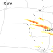
Iowa
| Local Time | Report Details |
|---|---|
| 2:57 PM CDT | Ping Pong Ball sized hail reported near Salem, IA, 29.4 miles N of Kahoka, MO, 911 center relayed a report from law enforcement of 1.50 inch hal. |
| 3:00 PM CDT | Golf Ball sized hail reported near Salem, IA, 28.7 miles N of Kahoka, MO |
| 3:07 PM CDT | Golf Ball sized hail reported near West Point, IA, 31.2 miles NNE of Kahoka, MO, dime to through golf ball size hail. |
| 3:15 PM CDT | Golf Ball sized hail reported near West Point, IA, 27.4 miles NNE of Kahoka, MO |
| 3:22 PM CDT | Grapefruit sized hail reported near West Point, IA, 29.9 miles NE of Kahoka, MO, fire department reports soft ball hail west of denmark... ia in northern lee county. |
Alabama
| Local Time | Report Details |
|---|---|
| 3:13 PM CDT | A large tree and power lines blown down along county road in sumter county AL, 69.8 miles WNW of Camden, AL |
| 3:18 PM CDT | A large tree and power lines were blown down along county road 74 in chilton county AL, 42.3 miles S of Birmingham, AL |
| 3:18 PM CDT | A large tree was blown down and took power lines out near cr 1 in sumter county AL, 70.6 miles WNW of Camden, AL |
| 3:30 PM CDT | A large tree blown down along lee road 379 near lee road 37 in lee county AL, 20.6 miles ENE of Auburn, AL |
| 3:30 PM CDT | A large tree was blown down near cr 9 and cr 1 in sumter county AL, 62.7 miles WNW of Camden, AL |
| 4:10 PM CDT | Hen Egg sized hail reported near Eclectic, AL, 31.8 miles W of Auburn, AL, hail size estimated. hail reported larger than golf ball but not quite baseball size. lasted about 5 minutes and covered the ground. |
| 4:11 PM CDT | Golf Ball sized hail reported near Eclectic, AL, 32.6 miles WNW of Auburn, AL, golfball size hail near lake martin. |
| 4:17 PM CDT | Quarter sized hail reported near Lisman, AL, 67.5 miles WNW of Camden, AL, reports of 1 inch hail near the community of cyril. |
| 4:25 PM CDT | A few trees were blown down near ware road and redland roa in elmore county AL, 33.4 miles WSW of Auburn, AL |
| 4:40 PM CDT | Quarter sized hail reported near Butler, AL, 53.3 miles W of Camden, AL, reports of hail the size of nickels and quarters just outside of butler. pictures and video via social media. |
| 4:40 PM CDT | Golf Ball sized hail reported near Butler, AL, 53.2 miles W of Camden, AL, pictures of golf ball sized hail on social media. |
| 4:41 PM CDT | Quarter sized hail reported near Notasulga, AL, 11.5 miles WSW of Auburn, AL |
| 4:45 PM CDT | Power lines down on lee road 112 near lee road 4 in lee county AL, 6.7 miles SE of Auburn, AL |
| 5:04 PM CDT | Quarter size hail covering the ground. the hail covered the ground in several location in lee county AL, 11.3 miles SE of Auburn, AL |
| 5:05 PM CDT | Several trees were blown down along highway 5 in lee county AL, 12.1 miles SSE of Auburn, AL |
| 6:34 PM CDT | Several trees down in madrid are in houston county AL, 73.7 miles NE of Miramar Beach, FL |
| 6:37 PM CDT | Wood fencing partly downed... few shingles removed from the roof of a house... and large tree across a driveway near turner lindsey road. time estimated from rada in lauderdale county AL, 20.9 miles E of Florence, AL |
| 6:42 PM CDT | Power lines were blown down and a shed was moved on ramer loop just off stateline roa in houston county AL, 73.6 miles WNW of Tallahassee, FL |
| 6:44 PM CDT | Numerous trees and a power line down in the cottonwood are in houston county AL, 72.9 miles NW of Tallahassee, FL |
| 6:45 PM CDT | Strong winds blew part of a structure into a utility pole on waddell roa in houston county AL, 71.2 miles NW of Tallahassee, FL |
| 12:55 AM CDT | Quarter sized hail reported near Huntsville, AL, 61.9 miles E of Florence, AL, occurred in the five points community of huntsville. |
| 1:03 AM CDT | Golf Ball sized hail reported near Waterloo, AL, 23.4 miles WNW of Florence, AL |
| 1:05 AM CDT | Tree down on house near the intersection of hwy 101 and cr 26 in lawrence county AL, 15.9 miles ESE of Florence, AL |
| 1:05 AM CDT | Tree down on riverton rose trai in colbert county AL, 23 miles W of Florence, AL |
| 1:29 AM CDT | Quarter sized hail reported near Sheffield, AL, 2.9 miles SSW of Florence, AL |
| 1:30 AM CDT | Tree down near watts bar st and norris ci in colbert county AL, 4.9 miles SSW of Florence, AL |
| 1:34 AM CDT | Tree down at the intersection of carter rd and shaw r in colbert county AL, 12.2 miles ESE of Florence, AL |
| 1:36 AM CDT | Quarter sized hail reported near Muscle Shoals, AL, 3.1 miles SSE of Florence, AL, report from mping: quarter (1.00 in.). |
| 1:47 AM CDT | Quarter sized hail reported near Hartselle, AL, 49.2 miles ESE of Florence, AL |
| 1:58 AM CDT | Tree down at the intersection of union grove road and mountain view roa in marshall county AL, 64.9 miles NNE of Birmingham, AL |
| 2:33 AM CDT | Large tree down on cr 46 near hwy 22 in dekalb county AL, 64.4 miles SW of Chattanooga, TN |
| 10:31 AM UTC | Quarter sized hail reported near Aliceville, AL, 44.8 miles ESE of Starkville, MS, social media reports of large hail near aliceville. |
| 5:57 AM CDT | Trees down on highway 1 in greene county AL, 68.1 miles NNW of Camden, AL |
Virginia
| Local Time | Report Details |
|---|---|
| 4:27 PM EDT | Ping Pong Ball sized hail reported near Rich Creek, VA, 49.7 miles W of Roanoke, VA, hail the size of silver dollar in rich creek. time estimated from radar. |
| 4:27 PM EDT | Quarter sized hail reported near Narrows, VA, 48.7 miles W of Roanoke, VA, quarter size hail in narrows. |
| 4:40 PM EDT | Storm damage reported in giles county VA, 33.5 miles W of Roanoke, VA |
| 4:45 PM EDT | Large trees down... some snapped off 25 to 30 u in pulaski county VA, 37.6 miles W of Roanoke, VA |
| 4:50 PM EDT | Quarter sized hail reported near Rocky Mount, VA, 16.8 miles S of Roanoke, VA, quarter size hail near rocky mount. |
| 4:55 PM EDT | Power line down on broce and toms creek r in montgomery county VA, 27.1 miles W of Roanoke, VA |
| 4:55 PM EDT | Quarter sized hail reported near Radford, VA, 36.4 miles WSW of Roanoke, VA, dime to quarter size hail. small limbs down. |
| 4:56 PM EDT | Several trees down on muse field r in franklin county VA, 18.9 miles SSE of Roanoke, VA |
| 5:00 PM EDT | Tree blown down across lucas street in christiansburg... blocking the roa in montgomery county VA, 27.4 miles WSW of Roanoke, VA |
| 5:01 PM EDT | 8 inch tree limb dow in montgomery county VA, 27.7 miles WSW of Roanoke, VA |
| 5:03 PM EDT | Several trees dow in montgomery county VA, 28.3 miles WSW of Roanoke, VA |
| 5:03 PM EDT | Trees snapped by thunderstorm wind gust in montgomery county VA, 28.6 miles WSW of Roanoke, VA |
| 5:05 PM EDT | Very large branch from pine tree snapped of in montgomery county VA, 28.1 miles WSW of Roanoke, VA |
| 5:15 PM EDT | Large tree blown down on mill run r in floyd county VA, 33.3 miles SW of Roanoke, VA |
| 5:15 PM EDT | Several trees down along route 8 in floyd count in floyd county VA, 32.2 miles SW of Roanoke, VA |
| 5:20 PM EDT | Quarter sized hail reported near Check, VA, 21.3 miles SW of Roanoke, VA |
| 5:20 PM EDT | Apple tree blown dow in wythe county VA, 67.4 miles WSW of Roanoke, VA |
| 5:26 PM EDT | Roof damage to a structure on queens knob roa in wythe county VA, 67.4 miles WSW of Roanoke, VA |
| 5:27 PM EDT | Quarter sized hail reported near Max Meadows, VA, 60 miles WSW of Roanoke, VA |
| 5:38 PM EDT | Tree down across route 57 west of chatham... blocking the entire roadwa in pittsylvania county VA, 41.9 miles SE of Roanoke, VA |
| 5:40 PM EDT | Several trees dow in pittsylvania county VA, 43 miles SE of Roanoke, VA |
| 5:40 PM EDT | Half Dollar sized hail reported near Ferrum, VA, 24.6 miles S of Roanoke, VA, hail from quarter size to half dollar size. |
| 5:40 PM EDT | Quarter sized hail reported near Chatham, VA, 42.7 miles SE of Roanoke, VA, hail up to the size of quarters covering the ground. |
| 5:40 PM EDT | Multiple trees down around chatham. many trees blocking the road. several power poles snappe in pittsylvania county VA, 43.5 miles SE of Roanoke, VA |
| 5:41 PM EDT | Quarter sized hail reported near Rocky Mount, VA, 26.7 miles S of Roanoke, VA, hail 1 inch in diameter fell on goose dam rd. |
| 5:47 PM EDT | Tree down on vehicle on mitchell farm l in henry county VA, 39.6 miles S of Roanoke, VA |
| 5:50 PM EDT | About a half dozen trees and one power line down in bassett area. one tree fell on mobile home. no one inside. time estimated from rada in henry county VA, 34.7 miles S of Roanoke, VA |
| 5:52 PM EDT | Two trees down in fieldale area. time estimated from rada in henry county VA, 38.7 miles S of Roanoke, VA |
| 6:01 PM EDT | Quarter sized hail reported near Martinsville, VA, 39.5 miles SSE of Roanoke, VA, quarter size hail. some dents in vehicles. |
| 6:05 PM EDT | Multiple trees uprooted. some snapped off mid trun in pittsylvania county VA, 36.7 miles SSE of Roanoke, VA |
| 6:26 PM EDT | Quarter sized hail reported near Danville, VA, 55.4 miles SSE of Roanoke, VA, report from mping: quarter size hail. |
| 6:30 PM EDT | Two trees dow in washington county VA, 17 miles ENE of Bristol, TN |
| 5:53 AM EDT | The henry county 911 center reports a large tree down on a power line near the intersection of evening star road and liza cour in henry county VA, 42.3 miles S of Roanoke, VA |
Illinois
| Local Time | Report Details |
|---|---|
| 3:31 PM CDT | Quarter sized hail reported near Carman, IL, 42.3 miles ENE of Kahoka, MO, dime to quarter sized hail occurring now. |
| 3:44 PM CDT | Quarter sized hail reported near Lomax, IL, 40.5 miles ENE of Kahoka, MO |
| 3:55 PM CDT | Half Dollar sized hail reported near Macomb, IL, 54.9 miles E of Kahoka, MO, via social media. |
| 3:59 PM CDT | Quarter sized hail reported near Galesburg, IL, 45.2 miles WNW of Peoria, IL |
| 4:09 PM CDT | Ping Pong Ball sized hail reported near Colchester, IL, 49 miles E of Kahoka, MO |
| 4:10 PM CDT | Golf Ball sized hail reported near Macomb, IL, 55.4 miles E of Kahoka, MO, 1.5 to 1.75 inch hail. |
| 4:12 PM CDT | Quarter sized hail reported near Macomb, IL, 51.1 miles WSW of Peoria, IL, multiple reports of 1 inch hail. |
| 4:15 PM CDT | Quarter sized hail reported near Macomb, IL, 54.5 miles WSW of Peoria, IL |
| 4:15 PM CDT | Storm damage reported in mcdonough county IL, 54.5 miles WSW of Peoria, IL |
| 4:25 PM CDT | Quarter sized hail reported near Augusta, IL, 42.7 miles ESE of Kahoka, MO, dime to quarter hail. |
| 4:35 PM CDT | Quincy asos reported a peak gust of 60 mp in adams county IL, 43.4 miles SE of Kahoka, MO |
| 4:54 PM CDT | Quarter sized hail reported near Galva, IL, 40.6 miles NW of Peoria, IL, emergency management and trained spotters reported hail that was between pea to quarter sized. also reported half inch hail along highway n300 near 1500 e highway. |
| 4:54 PM CDT | Storm damage reported in adams county IL, 43.4 miles SE of Kahoka, MO |
| 5:00 PM CDT | A large pine tree branch was blown dow in mason county IL, 34.5 miles S of Peoria, IL |
| 5:15 PM CDT | Two tractor trailers overturned on i-55 north of lincoln. one at mile marker 123 and another near mile marker 11 in logan county IL, 37.8 miles SSE of Peoria, IL |
| 5:15 PM CDT | Three tractor trailers were blown over on i-55 between lincoln and elkhar in logan county IL, 40.6 miles SSE of Peoria, IL |
| 5:15 PM CDT | Corrects previous tstm wnd dmg report from 3 ssw lincoln. trained spotter reported 20 power poles snapped along 1350th street near entrance to logan correctional center in logan county IL, 41.5 miles SSE of Peoria, IL |
| 5:16 PM CDT | Storm damage reported in logan county IL, 27.1 miles S of Peoria, IL |
| 5:20 PM CDT | Storm damage reported in logan county IL, 39.1 miles SSE of Peoria, IL |
| 5:20 PM CDT | Power poles down on primm road on the south side of lincoln. power lines down at railsplitter state par in logan county IL, 39.8 miles SSE of Peoria, IL |
| 5:21 PM CDT | At nws offic in logan county IL, 39.6 miles SSE of Peoria, IL |
| 5:23 PM CDT | Half Dollar sized hail reported near Sherman, IL, 55.4 miles S of Peoria, IL |
| 5:24 PM CDT | Delayed report. a portion of roof removed on a farm shed and downed tree in iroquois county IL, 69.7 miles SSW of Chicago, IL |
| 5:25 PM CDT | Several large trees were blown down...including one that crushed a campe in logan county IL, 49.8 miles SSE of Peoria, IL |
| 5:30 PM CDT | Sangamon county emergency manager reported that dawson fire dept reported 1 power pole down on dawson lane between dawson and riverto in sangamon county IL, 58.3 miles S of Peoria, IL |
| 5:30 PM CDT | Sangamon county emergency manager reported mechanicsburg fire dept reported one power pole down on john wayne roa in sangamon county IL, 59.1 miles WNW of Mattoon, IL |
| 5:30 PM CDT | Large tree branch broken off near the base. time estimate in logan county IL, 43.5 miles SSE of Peoria, IL |
| 5:31 PM CDT | Several trees blown down in de witt county IL, 49.7 miles SSE of Peoria, IL |
| 5:32 PM CDT | Ping Pong Ball sized hail reported near Riverton, IL, 58.2 miles S of Peoria, IL |
| 5:35 PM CDT | Tree blown down onto a trailer in de witt county IL, 50 miles SE of Peoria, IL |
| 5:38 PM CDT | A barn was destroyed with part of the structure being blown up to a mile from its foundatio in sangamon county IL, 53.2 miles WNW of Mattoon, IL |
| 5:41 PM CDT | Barn roofing was blown off in macon county IL, 49.2 miles NW of Mattoon, IL |
| 5:41 PM CDT | Trees down and roof damage reported by county emergency manage in macon county IL, 47.8 miles NW of Mattoon, IL |
| 5:41 PM CDT | Tree damage on the northeast side of warrensburg in macon county IL, 47.9 miles NW of Mattoon, IL |
| 5:41 PM CDT | The topflight grain elevator was damaged between maroa and forsyt in macon county IL, 46.5 miles NW of Mattoon, IL |
| 5:43 PM CDT | Grain bin was blown across road in christian county IL, 50.2 miles WNW of Mattoon, IL |
| 5:43 PM CDT | Quarter sized hail reported near Blue Mound, IL, 50.2 miles WNW of Mattoon, IL |
| 5:45 PM CDT | A barn door was blown off and an old evergreen was uprooted. a neighboring residence had a large tree blown down as wel in macon county IL, 49.2 miles NW of Mattoon, IL |
| 5:45 PM CDT | Delayed report. large grain bin damaged and moved slightl in iroquois county IL, 78.9 miles S of Chicago, IL |
| 5:47 PM CDT | Half Dollar sized hail reported near Alvin, IL, 70.2 miles NE of Mattoon, IL |
| 5:50 PM CDT | Storm damage reported in macon county IL, 40.1 miles NW of Mattoon, IL |
| 5:54 PM CDT | Thunderstorm wind gust at decatur airport of 60 mph at 554p in macon county IL, 39 miles NW of Mattoon, IL |
| 5:54 PM CDT | Thunderstorm wind gust at decatur airport of 60 mph at 554p in macon county IL, 39 miles NW of Mattoon, IL |
| 5:55 PM CDT | Power lines and trees were blown down. estimated wind gusts of 75 mp in piatt county IL, 32.7 miles NNW of Mattoon, IL |
| 5:55 PM CDT | Trained spotter reported 20 power poles snapped along 1350th street near entrance to logan correctional cente in logan county IL, 41.5 miles SSE of Peoria, IL |
| 5:55 PM CDT | A 66 mph gust was observed at the decatur airpor in macon county IL, 39 miles NW of Mattoon, IL |
| 5:55 PM CDT | A 66 mph gust was observed at the decatur airpor in macon county IL, 39 miles NW of Mattoon, IL |
| 5:55 PM CDT | Trees down. time estimate in piatt county IL, 39.2 miles NNW of Mattoon, IL |
| 5:56 PM CDT | Trained spotter reported power poles dow in macon county IL, 41.7 miles NW of Mattoon, IL |
| 5:56 PM CDT | Trained spotter reported power poles dow in macon county IL, 49.2 miles NW of Mattoon, IL |
| 6:00 PM CDT | Numerous power poles and power lines were blown down along route 105 between bement and monticell in piatt county IL, 32 miles NNW of Mattoon, IL |
| 6:02 PM CDT | Trained spotter reported 70-80 mph estimated wind in piatt county IL, 32.1 miles NNW of Mattoon, IL |
| 6:02 PM CDT | Trained spotter reported 70-80 mph estimated wind in piatt county IL, 32.1 miles NNW of Mattoon, IL |
| 6:02 PM CDT | Ping Pong Ball sized hail reported near Cutler, IL, 50.2 miles N of Cape Girardeau, MO |
| 6:05 PM CDT | A power pole was snapped on highway 3 in moultrie county IL, 25.2 miles NNW of Mattoon, IL |
| 6:07 PM CDT | A wall was blown out of a pole bar in piatt county IL, 25.3 miles NNW of Mattoon, IL |
| 6:07 PM CDT | Estimated winds by emergency manage in macon county IL, 47.8 miles NW of Mattoon, IL |
| 6:10 PM CDT | Three to five power poles were blown down west of pesotum at county road 100 and us highway 4 in champaign county IL, 29.7 miles N of Mattoon, IL |
| 6:12 PM CDT | Storm damage reported in champaign county IL, 42.5 miles NNE of Mattoon, IL |
| 6:13 PM CDT | Several one-foot diameter branches were blown down in champaign county IL, 30.1 miles N of Mattoon, IL |
| 6:14 PM CDT | Ping Pong Ball sized hail reported near Pinckneyville, IL, 54.4 miles N of Cape Girardeau, MO |
| 6:18 PM CDT | Semi blown off interstate 72 near mile post 150. from county e in macon county IL, 41.2 miles NW of Mattoon, IL |
| 6:22 PM CDT | Storm damage reported in champaign county IL, 35.7 miles NE of Mattoon, IL |
| 6:25 PM CDT | Quarter sized hail reported near Du Quoin, IL, 49.8 miles NNE of Cape Girardeau, MO |
| 6:30 PM CDT | Storm damage reported in vermilion county IL, 60.7 miles NE of Mattoon, IL |
| 6:32 PM CDT | Report from mping: 1-inch tree limbs broken; shingles blown of in vermilion county IL, 61.6 miles NE of Mattoon, IL |
| 6:33 PM CDT | Corrects previous tstm wnd dmg report from danville. county emergency manager reported that law enforcement reported tree down in danville on bowman and may stree in vermilion county IL, 60.7 miles NE of Mattoon, IL |
| 6:34 PM CDT | Multiple reports of roofs being blown off buildings in danville... on bensyl and emerson and 100 block of north walnu in vermilion county IL, 60.7 miles NE of Mattoon, IL |
| 6:34 PM CDT | Report from mping: 1-inch tree limbs broken; shingles blown of in coles county IL, 24.5 miles ENE of Mattoon, IL |
| 6:40 PM CDT | Numerous semis blown over and interstate 57 is closed south of arcol in douglas county IL, 13.6 miles NNE of Mattoon, IL |
| 6:40 PM CDT | Wooden fence blown over. time estimate in vermilion county IL, 54.3 miles NE of Mattoon, IL |
| 6:42 PM CDT | Peak wind repor in coles county IL, 0.3 miles ESE of Mattoon, IL |
| 6:43 PM CDT | Several large branches were blown down with winds estimated in excess of 65 mph. power was knocked ou in coles county IL, 5.8 miles SW of Mattoon, IL |
| 6:46 PM CDT | Power outage due to thunderstorm wind in jackson county IL, 23.4 miles N of Cape Girardeau, MO |
| 6:50 PM CDT | Wind gust recorded at county emergency management offic in vermilion county IL, 58.1 miles NE of Mattoon, IL |
| 6:50 PM CDT | Semi blown over on highway 1 on south end of tow in vermilion county IL, 55 miles NE of Mattoon, IL |
| 6:55 PM CDT | A house was damaged and power lines were blown dow in edgar county IL, 45.8 miles NE of Mattoon, IL |
| 6:55 PM CDT | Storm damage reported in edgar county IL, 37.9 miles ENE of Mattoon, IL |
| 6:55 PM CDT | Large tree branch broken off... damaging a chain link fenc in effingham county IL, 26.6 miles SSW of Mattoon, IL |
| 6:55 PM CDT | Pine tree blown dow in edgar county IL, 37.2 miles ENE of Mattoon, IL |
| 6:56 PM CDT | Sign blown over at orchard inn taver in effingham county IL, 25.8 miles SSW of Mattoon, IL |
| 7:00 PM CDT | Tree branch dow in champaign county IL, 60.2 miles NNE of Mattoon, IL |
| 7:00 PM CDT | A gustnado on the leading edge of thunderstorms damaged power lines on the north side of martinsvill in clark county IL, 28.3 miles ESE of Mattoon, IL |
| 7:05 PM CDT | Several damaged utility poles on 1000th st. between highway 40 and 1200th rd. report via wtwo-t in clark county IL, 31.3 miles ESE of Mattoon, IL |
| 7:15 PM CDT | Storm damage reported in clay county IL, 42.2 miles S of Mattoon, IL |
| 7:15 PM CDT | Shed destroyed. from county emergency manage in vermilion county IL, 48.7 miles NE of Mattoon, IL |
| 7:25 PM CDT | Several trees and power poles were blown dow in crawford county IL, 41.6 miles SE of Mattoon, IL |
| 7:28 PM CDT | A barn was blown ove in richland county IL, 50.7 miles SSE of Mattoon, IL |
| 7:30 PM CDT | Quarter sized hail reported near Herrin, IL, 44.4 miles NE of Cape Girardeau, MO |
| 7:33 PM CDT | Several trees and power poles were blown dow in crawford county IL, 47.1 miles SE of Mattoon, IL |
| 7:40 PM CDT | A tree was blown onto a hous in crawford county IL, 55.2 miles SE of Mattoon, IL |
| 7:42 PM CDT | Two large trees were blown dow in lawrence county IL, 51.1 miles NNW of Evansville, IN |
| 7:47 PM CDT | Report from mping: trees uprooted or snappe in lawrence county IL, 51.6 miles N of Evansville, IN |
| 7:52 PM CDT | Report from mping: trees uprooted or snapped; roof blown of in lawrence county IL, 50.6 miles NNW of Evansville, IN |
| 7:55 PM CDT | Storm damage reported in clay county IL, 54.7 miles S of Mattoon, IL |
| 7:55 PM CDT | Awos at mount carmel airpor in lawrence county IL, 43.1 miles N of Evansville, IN |
| 8:43 PM CDT | Quarter sized hail reported near Tamms, IL, 15.7 miles ESE of Cape Girardeau, MO |
Georgia
| Local Time | Report Details |
|---|---|
| 4:43 PM EDT | Half Dollar sized hail reported near Ashburn, GA, 49.2 miles WNW of Douglas, GA, large hail over 1 inch in diameter reported in ashburn. |
| 4:47 PM EDT | Half Dollar sized hail reported near Sycamore, GA, 48 miles WNW of Douglas, GA, quarter to half dollar sized hail reported. |
| 4:50 PM EDT | Tree down at hwy 32 east and bethel roa in turner county GA, 43.8 miles WNW of Douglas, GA |
| 6:50 PM EDT | Report of trees downed in macon county along ga-329 near the dooly county lin in macon county GA, 81.6 miles NW of Douglas, GA |
| 6:50 PM EDT | Report of trees downed in macon county along ga-329 near the dooly county lin in macon county GA, 83.4 miles NW of Douglas, GA |
| 8:15 PM EDT | Tree down on a home near coward farms on hwy 56 in toombs county GA, 46.4 miles NE of Douglas, GA |
| 8:20 PM EDT | Tree down on a home on clifford rogers rd in toombs county GA, 49.7 miles NE of Douglas, GA |
| 8:20 PM EDT | Several trees and powerlines down in the vacinity of hwy 178 and hwy 5 in toombs county GA, 53 miles NE of Douglas, GA |
| 8:23 PM EDT | Tree on house... possible tornad in berrien county GA, 35.2 miles SSW of Douglas, GA |
| 8:25 PM EDT | Trees and power lines down... light poles snapped. likely tornad in lanier county GA, 35.8 miles SSW of Douglas, GA |
| 8:25 PM EDT | Tree on house on thigpen ci in lanier county GA, 37.9 miles SSW of Douglas, GA |
| 8:27 PM EDT | Trees and powerlines down near royals road and lee road. tornado possibl in lanier county GA, 35.2 miles SSW of Douglas, GA |
| 8:29 PM EDT | Tree on house highway 37 west. tornado possibl in lanier county GA, 35.2 miles SSW of Douglas, GA |
| 8:30 PM EDT | Tree on a house at pine st. and 3rd ave. tornado possibl in lanier county GA, 35.1 miles SSW of Douglas, GA |
| 8:30 PM EDT | Emergency manager reports around 100 trees down with main area being along highway 147 near us 1. these trees blocked a large section of 147 which is a main evacuation in toombs county GA, 43.1 miles NE of Douglas, GA |
| 8:30 PM EDT | Large tree down on a power lin in lanier county GA, 34.6 miles SSW of Douglas, GA |
| 8:30 PM EDT | Numerous trees down around the banks lake area. one tree is on the dam. likely a tornad in lanier county GA, 35.3 miles SSW of Douglas, GA |
| 8:32 PM EDT | Trees down... possible tornad in lanier county GA, 35.3 miles SSW of Douglas, GA |
| 8:32 PM EDT | Steeple blown off a church near highway 22 in lanier county GA, 34.6 miles SSW of Douglas, GA |
| 8:33 PM EDT | Trees and powerlines down around the lakeshore drive area and temple street. tornado possibl in lanier county GA, 34.6 miles SSW of Douglas, GA |
| 8:33 PM EDT | Trees down at burnt church road. tornado possibl in lanier county GA, 36.4 miles SSW of Douglas, GA |
| 9:00 PM EDT | Quarter sized hail reported near Homerville, GA, 32.1 miles S of Douglas, GA, quarter-sized ail has been reported falling on hwy 37... west of homerville... measuring 1 inch in diameter. |
| 3:37 AM EDT | Report of a tree down on a house on kraftsman road in floyd county GA, 55.6 miles S of Chattanooga, TN |
| 3:39 AM EDT | Report of a tree down on a house on smith st ne in rom in floyd county GA, 54.9 miles S of Chattanooga, TN |
| 4:40 AM EDT | Large tree down on magnolia st in roswell... covering the road and bringing down powerline in fulton county GA, 18.8 miles N of Atlanta, GA |
| 4:41 AM EDT | Trees reported down in buchanan in haralson county GA, 46.1 miles W of Atlanta, GA |
| 5:03 AM EDT | Report of a large tree down near rose ave and selman dr in douglasville in douglas county GA, 21.2 miles W of Atlanta, GA |
| 5:56 AM EDT | Quarter sized hail reported near Juliette, GA, 55.3 miles SE of Atlanta, GA, reports of quarter-sized hail in juliette. |
Tennessee
| Local Time | Report Details |
|---|---|
| 4:00 PM CDT | Large tree down in milledgevill in mcnairy county TN, 52.6 miles S of Mc Kenzie, TN |
| 4:08 PM CDT | Received two reports of trees down and power outages on jerter road adn morrison creek road. time estimated via rada in wayne county TN, 44.1 miles NNW of Florence, AL |
| 4:24 PM CDT | Quarter sized hail reported near Waynesboro, TN, 36.1 miles N of Florence, AL, received a report of 1"hail. time estimated from radar. |
| 4:24 PM CDT | Received a report of some trees down in waynesboro. time estimated via rada in wayne county TN, 36.1 miles N of Florence, AL |
| 4:58 PM CDT | Golf Ball sized hail reported near Westpoint, TN, 31.4 miles NNE of Florence, AL, received a report of golf ball size hail on pondfield road. |
| 5:00 PM CDT | Quarter sized hail reported near Mount Juliet, TN, 14.7 miles ENE of Nashville, TN, picture of dime to quarter size hail. time estimated via radar. |
| 5:01 PM CDT | Report of tree on power line that started a fire... knob creek road. time estimated via rada in lawrence county TN, 29.5 miles NNE of Florence, AL |
| 5:14 PM CDT | Report of a wind gust of 50 to 60 mph by a trained spotter. location is 8 mile south of leoma. time estimated via reada in lawrence county TN, 29.3 miles NNE of Florence, AL |
| 5:34 PM CDT | Report of a 12" diameter tree down on union hill church. also multiple reports of trees down in this area. time estimated via rada in lawrence county TN, 31.3 miles NE of Florence, AL |
| 5:34 PM CDT | Report of a 12" diameter tree down on union hill church. also multiple reports of trees down in this area. time estimated via rada in lawrence county TN, 31.3 miles NE of Florence, AL |
| 5:48 PM CDT | Quarter sized hail reported near Old Hickory, TN, 9.1 miles ENE of Nashville, TN, picture of 1" hail. |
| 6:06 PM CDT | Quarter sized hail reported near Carthage, TN, 46.4 miles ENE of Nashville, TN, 1" hail report. time estimated via radar. |
| 8:36 PM CDT | Quarter sized hail reported near Buchanan, TN, 28.8 miles NE of Mc Kenzie, TN |
| 8:46 PM CDT | Quarter sized hail reported near Cottage Grove, TN, 17.2 miles N of Mc Kenzie, TN |
| 8:54 PM CDT | Quarter sized hail reported near Dover, TN, 44.9 miles ENE of Mc Kenzie, TN, report of quarter size hail and winds to 58 miles an hour. time estimated via radar. |
| 9:00 PM CDT | Report of shingles off a roof on tiny town road. time estimated via rada in montgomery county TN, 41.8 miles NW of Nashville, TN |
| 9:06 PM CDT | Reports of trees down on rossview road and cooper creek road. time estimated via rada in montgomery county TN, 41.8 miles NW of Nashville, TN |
| 9:14 PM CDT | Report of estimated wind gust of 65 mp in montgomery county TN, 41.8 miles NW of Nashville, TN |
| 9:30 PM CDT | Report of trees down in barren plains. time estimated via rada in robertson county TN, 30.8 miles NNW of Nashville, TN |
| 9:36 PM CDT | Trees down kinney's road and airport road. also highway 161 and taylor road. time estimated via rada in robertson county TN, 23.6 miles NNW of Nashville, TN |
| 9:50 PM CDT | Report of trees down on union road and highway 76. also spuratic trees down across the county. time estimated via rada in robertson county TN, 21 miles NNE of Nashville, TN |
| 9:58 PM CDT | Part of a tree snapped and fell on power lines pulling them out of a hous in sumner county TN, 13.1 miles NE of Nashville, TN |
| 10:06 PM CDT | Report of power pole snapped in half and a couple of trees down around coles ferry road... drivers lane. time estimated via rada in sumner county TN, 24.4 miles NE of Nashville, TN |
| 10:10 PM CDT | Half inch hail and small limbs down on desha creek roa in sumner county TN, 23.5 miles NE of Nashville, TN |
| 10:24 PM CDT | Trees down on cainsville roa in wilson county TN, 25.8 miles E of Nashville, TN |
| 10:25 PM CDT | Report of 60 mph wind gus in wilson county TN, 20.6 miles E of Nashville, TN |
| 10:36 PM CDT | Multiple trees were blown down along country club road and rehoboth road. a few other trees were blown down across portions of fayette count in fayette county TN, 43 miles E of Memphis, TN |
| 1:26 AM EDT | Multiple trees down across the count in loudon county TN, 39.6 miles WSW of Knoxville, TN |
| 12:35 AM CDT | Quarter sized hail reported near Michie, TN, 46.4 miles WNW of Florence, AL, hail up to the size of quarters. |
| 12:35 AM CDT | Multiple trees and power lines down from eastview and guys to michi in mcnairy county TN, 53.5 miles WNW of Florence, AL |
| 12:45 AM CDT | Downed tree fell through window in a home in counc in hardin county TN, 38.1 miles WNW of Florence, AL |
| 1:54 AM EDT | Large tree down on hiwassee stree in bradley county TN, 28.4 miles ENE of Chattanooga, TN |
| 2:33 AM EDT | A couple small trees down in the new center are in sevier county TN, 27.5 miles ESE of Knoxville, TN |
North Carolina
| Local Time | Report Details |
|---|---|
| 5:46 PM EDT | Quarter sized hail reported near Roxboro, NC, 48 miles N of Raleigh, NC, estimated 1 inch hail on the person county - granville county line... about 3 miles south of the virginia border. |
| 5:49 PM EDT | Tree down on the 300 block of hesters store r in person county NC, 45.4 miles NNW of Raleigh, NC |
| 5:49 PM EDT | Tree down on the 2000 block of paynes tavern r in person county NC, 43.7 miles NNW of Raleigh, NC |
| 5:56 PM EDT | Quarter sized hail reported near Roxboro, NC, 46.4 miles NNW of Raleigh, NC, trained spotter reported quarter size hail. |
| 5:57 PM EDT | Tree down on the 2200 block of clay long r in person county NC, 40.1 miles NNW of Raleigh, NC |
| 6:07 PM EDT | Tree down on hwy 14 and della d in rockingham county NC, 51 miles S of Roanoke, VA |
| 6:22 PM EDT | Large limbs down and metal roof peeled back on a building in reidsville. shingles and tile blown off of roof in rockingham county NC, 64.6 miles SSE of Roanoke, VA |
| 6:23 PM EDT | Flag torn off flag pol in rockingham county NC, 64.7 miles SSE of Roanoke, VA |
| 6:30 PM EDT | Quarter sized hail reported near Creedmoor, NC, 24.7 miles N of Raleigh, NC, quarter-sized hail at nc highway 56 w and birch dr in creedmoor. |
| 6:43 PM EDT | Large tree down blocking south elam avenue at sherwood street in greensbor in guilford county NC, 69.4 miles WNW of Raleigh, NC |
| 6:52 PM EDT | Report from mping: 3-inch tree limbs broken; power poles broke in alamance county NC, 46.7 miles WNW of Raleigh, NC |
| 6:53 PM EDT | 18-inch diameter tree snapped by wind on hopkins trace lane in zebulo in wake county NC, 18.5 miles ENE of Raleigh, NC |
| 6:54 PM EDT | 50 knot wind gust measured by the asos at the burlington-alamance regional airpor in alamance county NC, 50.4 miles WNW of Raleigh, NC |
| 7:07 PM EDT | Tree down at taylors mill rd and noah rd in middlese in nash county NC, 23.2 miles E of Raleigh, NC |
| 7:10 PM EDT | Tree down at old middlesex rd and planer mill rd in middlese in nash county NC, 25.4 miles E of Raleigh, NC |
| 7:30 PM EDT | Tree down on 6100 block of s plank r in lee county NC, 46.4 miles SW of Raleigh, NC |
| 7:31 PM EDT | Quarter sized hail reported near Lucama, NC, 36.8 miles ESE of Raleigh, NC, quarter-sized hail at us highway 301 and main st. |
| 7:32 PM EDT | Quarter sized hail reported near Wilson, NC, 40.1 miles E of Raleigh, NC, quarter-sized hail at forest hills rd nw and highway 42 in wilson. |
| 7:53 PM EDT | Two trees down behind residence near n rogers ln and new bern ave in knightdal in wake county NC, 5.2 miles E of Raleigh, NC |
| 7:57 PM EDT | Quarter sized hail reported near Raleigh, NC, 5.2 miles E of Raleigh, NC, nickel to quarter sized hail at n rogers ln and new bern ave in knightdale. |
| 8:01 PM EDT | Tree down on hull road and highway 5 in greene county NC, 58.4 miles ESE of Raleigh, NC |
| 8:20 PM EDT | Cable line down in smithfiel in johnston county NC, 25.5 miles SE of Raleigh, NC |
| 8:20 PM EDT | Tree down by boat ramp river roa in lenoir county NC, 69.5 miles ESE of Raleigh, NC |
| 8:24 PM EDT | Tree down across roadway on south walton ave in benso in johnston county NC, 28.5 miles SSE of Raleigh, NC |
| 9:00 PM EDT | Quarter sized hail reported near Matthews, NC, 9.3 miles SE of Charlotte, NC, dime to quarter size hail reported south of charlotte. |
| 9:05 PM EDT | Quarter sized hail reported near Charlotte, NC, 13.3 miles S of Charlotte, NC, quarter size hail reported off longstone ln. |
Missouri
| Local Time | Report Details |
|---|---|
| 5:32 PM CDT | Golf Ball sized hail reported near West Plains, MO, 79.5 miles SSW of Salem, MO, corrects previous hail report from 5 w lanton. |
| 5:35 PM CDT | Corrects previous tstm wnd dmg report from 2 ese bonne terre. 3 inch tree limbs broken... power poles broke in st. francois county MO, 52.3 miles SSW of Saint Louis, MO |
| 5:37 PM CDT | Golf Ball sized hail reported near West Plains, MO, 79.5 miles SSW of Salem, MO |
| 5:38 PM CDT | Quarter sized hail reported near Greenville, MO, 40.5 miles W of Cape Girardeau, MO |
| 5:41 PM CDT | Golf Ball sized hail reported near Thayer, MO, 72.4 miles S of Salem, MO |
| 5:42 PM CDT | Quarter sized hail reported near Greenville, MO, 38.6 miles W of Cape Girardeau, MO, report from mping: quarter (1.00 in.). |
| 5:45 PM CDT | 3 inch tree limbs broken... power poles broke in st. francois county MO, 52.3 miles SSW of Saint Louis, MO |
| 5:45 PM CDT | Golf Ball sized hail reported near Greenville, MO, 38 miles W of Cape Girardeau, MO |
| 5:49 PM CDT | Golf Ball sized hail reported near Thayer, MO, 71.6 miles S of Salem, MO, picture of golf ball size hail. |
| 5:53 PM CDT | Golf Ball sized hail reported near Glenallen, MO, 32.3 miles W of Cape Girardeau, MO |
| 5:59 PM CDT | Golf Ball sized hail reported near Zalma, MO, 31.6 miles WSW of Cape Girardeau, MO, time estimated from radar. |
| 5:59 PM CDT | Quarter sized hail reported near Farmington, MO, 58.7 miles NW of Cape Girardeau, MO |
| 6:06 PM CDT | Quarter sized hail reported near Farmington, MO, 50.8 miles NW of Cape Girardeau, MO |
| 6:12 PM CDT | Half Dollar sized hail reported near Alton, MO, 65.9 miles S of Salem, MO, social media report near alton. |
| 6:13 PM CDT | Quarter sized hail reported near Advance, MO, 24.5 miles SW of Cape Girardeau, MO |
| 6:17 PM CDT | Quarter sized hail reported near Winfield, MO, 43.5 miles NW of Saint Louis, MO, report from mping: quarter (1.00 in.). |
| 6:26 PM CDT | Quarter sized hail reported near Perryville, MO, 33.3 miles NNW of Cape Girardeau, MO, report from mping: quarter (1.00 in.). |
| 6:34 PM CDT | Reported at kse in st. charles county MO, 24.3 miles NNW of Saint Louis, MO |
| 6:39 PM CDT | Quarter sized hail reported near Frohna, MO, 23.7 miles NNW of Cape Girardeau, MO |
| 6:41 PM CDT | Several tree tops broken off in frohna and altenburg. live 10 inch tree trunks snapped. trampolines displaced. power outages on the west side of altenbur in perry county MO, 22.7 miles N of Cape Girardeau, MO |
| 6:45 PM CDT | Quarter sized hail reported near Sikeston, MO, 29.2 miles S of Cape Girardeau, MO |
| 6:46 PM CDT | Quarter sized hail reported near Doniphan, MO, 65.6 miles SSE of Salem, MO, report from mping: quarter (1.00 in.). |
| 6:50 PM CDT | Ping Pong Ball sized hail reported near Sikeston, MO, 24.3 miles S of Cape Girardeau, MO, report from mping: ping pong ball (1.50 in.). |
| 6:50 PM CDT | Quarter sized hail reported near Sikeston, MO, 27.2 miles S of Cape Girardeau, MO |
| 6:51 PM CDT | Hen Egg sized hail reported near Sikeston, MO, 29.2 miles S of Cape Girardeau, MO, numerous reports of 1 to 2 inch hail with 2.25 inches begin the largest. |
| 6:54 PM CDT | Hen Egg sized hail reported near Sikeston, MO, 28.5 miles S of Cape Girardeau, MO, broadcast media pictures of hail in miner. time estiamted from radar. |
| 7:12 PM CDT | Quarter sized hail reported near Ellsinore, MO, 66.2 miles SE of Salem, MO |
| 7:12 PM CDT | Quarter sized hail reported near Poplar Bluff, MO, 68.3 miles WSW of Cape Girardeau, MO, corrects previous hail report from 2 ene ellsinore. |
| 7:13 PM CDT | Quarter sized hail reported near Charleston, MO, 28.7 miles SSE of Cape Girardeau, MO |
| 7:52 PM CDT | Quarter sized hail reported near Cape Girardeau, MO, 2.1 miles NNW of Cape Girardeau, MO, report from mping: quarter (1.00 in.). |
| 7:52 PM CDT | Quarter sized hail reported near Cape Girardeau, MO, 2.7 miles NE of Cape Girardeau, MO |
| 7:56 PM CDT | Quarter sized hail reported near Cape Girardeau, MO, 3.1 miles NE of Cape Girardeau, MO |
| 8:23 PM CDT | Quarter sized hail reported near Millersville, MO, 16.6 miles WNW of Cape Girardeau, MO |
| 8:56 PM CDT | Quarter sized hail reported near Cape Girardeau, MO, 3.1 miles NW of Cape Girardeau, MO, report from mping: quarter (1.00 in.). |
| 10:00 PM CDT | Quarter sized hail reported near Senath, MO, 67.9 miles N of Memphis, TN |
Connect with Interactive Hail Maps