

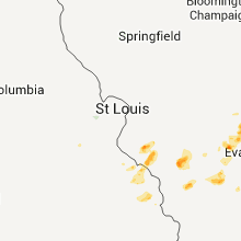
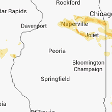
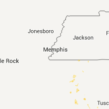
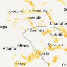
Hail Map for Sunday, July 1, 2012

Number of Impacted Households on 7/1/2012
0
Impacted by 1" or Larger Hail
0
Impacted by 1.75" or Larger Hail
0
Impacted by 2.5" or Larger Hail
Square Miles of Populated Area Impacted on 7/1/2012
0
Impacted by 1" or Larger Hail
0
Impacted by 1.75" or Larger Hail
0
Impacted by 2.5" or Larger Hail


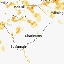
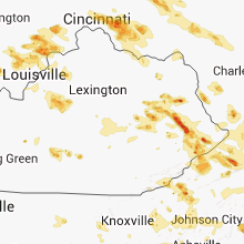

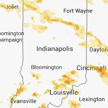
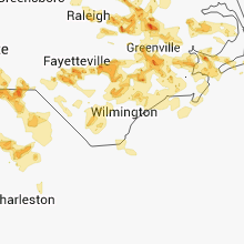


Cities Most Affected by Hail Storms of 7/1/2012
| Hail Size | Demographics of Zip Codes Affected | ||||||
|---|---|---|---|---|---|---|---|
| City | Count | Average | Largest | Pop Density | House Value | Income | Age |
| Fayetteville, NC | 6 | 1.88 | 2.50 | 557 | $83k | $30.3k | 37.0 |
| Chesterfield, SC | 4 | 1.81 | 2.00 | 60 | $64k | $32.0k | 40.9 |
| North Vernon, IN | 4 | 1.81 | 2.00 | 109 | $81k | $39.1k | 37.6 |
| Chillicothe, OH | 3 | 1.83 | 2.00 | 157 | $88k | $37.1k | 39.7 |
| Raleigh, NC | 3 | 1.75 | 1.75 | 1484 | $230k | $87.8k | 36.1 |
| West Columbia, SC | 2 | 2.00 | 2.00 | 1229 | $91k | $38.8k | 37.6 |
| Gilbert, SC | 2 | 1.88 | 2.00 | 175 | $122k | $49.3k | 40.4 |
| Hickory, NC | 2 | 1.88 | 2.00 | 413 | $89k | $36.7k | 39.0 |
| Pageland, SC | 2 | 1.88 | 2.00 | 97 | $66k | $28.9k | 36.1 |
| Raeford, NC | 2 | 1.75 | 1.75 | 275 | $84k | $33.8k | 30.3 |
| Chapin, SC | 2 | 1.75 | 1.75 | 384 | $187k | $65.2k | 43.9 |
| Port Clinton, OH | 2 | 1.75 | 1.75 | 392 | $112k | $38.9k | 47.9 |
| Roxboro, NC | 2 | 1.75 | 1.75 | 604 | $86k | $35.4k | 40.6 |
| Cheraw, SC | 2 | 1.75 | 1.75 | 103 | $71k | $30.3k | 41.2 |
| Trenton, SC | 2 | 1.75 | 1.75 | 54 | $82k | $35.5k | 36.4 |
| Frankfort, OH | 1 | 2.75 | 2.75 | 54 | $86k | $38.2k | 40.6 |
| Middlesex, NC | 1 | 2.75 | 2.75 | 116 | $88k | $33.7k | 36.6 |
| Cheshire, CT | 1 | 2.00 | 2.00 | 820 | $212k | $80.5k | 42.2 |
| Clinton, CT | 1 | 2.00 | 2.00 | 878 | $167k | $60.5k | 43.9 |
| Lanett, AL | 1 | 2.00 | 2.00 | 145 | $60k | $30.0k | 42.2 |
| Ozark, IL | 1 | 2.00 | 2.00 | 18 | $53k | $28.6k | 46.5 |
| Toledo, OH | 1 | 2.00 | 2.00 | 3555 | $114k | $38.4k | 30.8 |
| Granite Falls, NC | 1 | 1.75 | 1.75 | 318 | $94k | $39.8k | 39.9 |
| Holland, OH | 1 | 1.75 | 1.75 | 893 | $153k | $53.1k | 41.2 |
| Flat Rock, MI | 1 | 1.75 | 1.75 | 1264 | $143k | $52.5k | 37.4 |
| Kingstree, SC | 1 | 1.75 | 1.75 | 78 | $64k | $22.8k | 38.5 |
| Lakeside Marblehead, OH | 1 | 1.75 | 1.75 | 579 | $128k | $42.0k | 54.9 |
| Valley, AL | 1 | 1.75 | 1.75 | 274 | $59k | $32.7k | 39.1 |
| Collettsville, NC | 1 | 1.75 | 1.75 | 11 | $83k | $29.1k | 45.4 |
| Goshen, OH | 1 | 1.75 | 1.75 | 244 | $99k | $45.5k | 40.3 |
| Chicago, IL | 1 | 1.75 | 1.75 | 5466 | $90k | $35.5k | 35.4 |
| Watertown, CT | 1 | 1.75 | 1.75 | 523 | $171k | $67.9k | 45.0 |
| Parkton, NC | 1 | 1.75 | 1.75 | 190 | $92k | $39.0k | 32.9 |
| Leesville, SC | 1 | 1.75 | 1.75 | 98 | $100k | $41.5k | 41.3 |
| Wolcott, CT | 1 | 1.75 | 1.75 | 799 | $143k | $61.5k | 42.7 |
| Spartanburg, SC | 1 | 1.75 | 1.75 | 1174 | $96k | $38.1k | 36.1 |
| Lexington, SC | 1 | 1.75 | 1.75 | 528 | $94k | $43.2k | 35.5 |
| Town Creek, AL | 1 | 1.75 | 1.75 | 50 | $70k | $31.3k | 40.7 |
| South Rockwood, MI | 1 | 1.75 | 1.75 | 157 | $144k | $57.0k | 42.0 |
| Lenoir, NC | 1 | 1.75 | 1.75 | 139 | $82k | $33.2k | 42.1 |
| Plum Branch, SC | 1 | 1.75 | 1.75 | 13 | $47k | $21.8k | 48.4 |
| Christopher, IL | 1 | 1.75 | 1.75 | 1124 | $36k | $25.1k | 42.2 |
| Smithfield, NC | 1 | 1.75 | 1.75 | 214 | $101k | $33.2k | 37.3 |
| Bethlehem, CT | 1 | 1.75 | 1.75 | 160 | $211k | $67.9k | 47.1 |
| Salem, IN | 1 | 1.75 | 1.75 | 75 | $78k | $36.3k | 39.5 |
| Maumee, OH | 1 | 1.75 | 1.75 | 1531 | $130k | $51.0k | 41.0 |
| Waxhaw, NC | 1 | 1.75 | 1.75 | 434 | $173k | $59.3k | 37.3 |
| Cedar Bluff, VA | 1 | 1.75 | 1.75 | 49 | $73k | $28.4k | 44.5 |
| Claudville, VA | 1 | 1.75 | 1.75 | 28 | $74k | $30.3k | 43.1 |
| Juliette, GA | 1 | 1.75 | 1.75 | 47 | $94k | $51.0k | 42.6 |
| Dearing, GA | 1 | 1.75 | 1.75 | 63 | $72k | $30.9k | 39.0 |
| Burfordville, MO | 1 | 1.75 | 1.75 | 33 | $121k | $49.4k | 47.8 |
| Grovetown, GA | 1 | 1.75 | 1.75 | 664 | $103k | $40.9k | 32.1 |
| Iron Station, NC | 1 | 1.75 | 1.75 | 181 | $98k | $41.2k | 40.7 |
| Olar, SC | 1 | 1.75 | 1.75 | 18 | $54k | $26.0k | 43.5 |
| Oakville, CT | 1 | 1.75 | 1.75 | 2565 | $124k | $47.7k | 42.3 |
| Allendale, IL | 1 | 1.75 | 1.75 | 20 | $56k | $35.8k | 39.5 |
Hail and Wind Damage Spotted on 7/1/2012
Filter by Report Type:Hail ReportsWind Reports
States Impacted
Iowa, Kentucky, Virginia, Illinois, North Carolina, Tennessee, New York, Indiana, South Carolina, Connecticut, Alabama, Mississippi, Rhode Island, Massachusetts, Georgia, Missouri, Minnesota, New Jersey, Ohio, Michigan, Montana, Louisiana, Wyoming, South Dakota, North Dakota, West Virginia, Florida, MarylandIowa
| Local Time | Report Details |
|---|---|
| 7:25 AM CDT | A tree fell on a house and power lines. time estimated off rada in van buren county IA, 34 miles NNW of Kahoka, MO |
| 7:25 AM CDT | Tree limbs down on oak grove avenue. time estimated off rada in van buren county IA, 32.6 miles NNW of Kahoka, MO |
| 7:28 AM CDT | Quarter sized hail reported near Douds, IA, 32.9 miles NW of Kahoka, MO, about 5 mins of quarter size hail. |
| 8:08 AM CDT | 10 to 12 inch diameter tree snapped down on corner of long meadow and swan street in des moines county IA, 39.5 miles NE of Kahoka, MO |
| 8:08 AM CDT | 8 inch tree limb down on top of house near the 200th block of broadway street...time estimated from rada in des moines county IA, 40.3 miles NE of Kahoka, MO |
| 11:07 AM CDT | Power lines downed by winds...elevated fuel tank blown over...and a barn door blown 20 feet. dime size hail also reporte in mahaska county IA, 52.9 miles ESE of Des Moines, IA |
Kentucky
| Local Time | Report Details |
|---|---|
| 9:25 AM EDT | Quarter sized hail reported near Fedscreek, KY, 54.5 miles N of Bristol, TN, quarter size hail completely covered the ground. |
| 9:55 AM EDT | Two trees blown down in mouthcard in pike county KY, 54.4 miles N of Bristol, TN |
| 5:10 PM CDT | Reports of numerous trees down...power outages...and a partial structure collapse in downtown sturgi in union county KY, 37.6 miles SW of Evansville, IN |
| 6:43 PM EDT | Downed trees blocking hwy 421 in the milton are in trimble county KY, 53.3 miles NNE of Louisville, KY |
| 6:54 PM EDT | *** 1 inj *** multiple trees down in the area. one tree fell on a car causing an injur in carroll county KY, 49.4 miles SW of Cincinnati, OH |
| 6:54 PM EDT | Multiple trees down in the area. one tree fell on a car causing an injur in carroll county KY, 49.4 miles SW of Cincinnati, OH |
| 6:54 PM EDT | *** 1 inj *** multiple trees down in the area. one tree fell on a car causing an injur in carroll county KY, 49.4 miles SW of Cincinnati, OH |
| 6:03 PM CDT | Large tree down in hawesville in perry county KY, 44.2 miles E of Evansville, IN |
| 7:39 PM EDT | Tree limbs down in city. several other trees down across the county. time estimated from rada in carroll county KY, 46 miles SW of Cincinnati, OH |
| 6:40 PM CDT | Tree down on a power line in breckinridge county KY, 51.1 miles WSW of Louisville, KY |
| 7:50 PM EDT | Tree across liberty road in west libert in morgan county KY, 40.2 miles ENE of Irvine, KY |
| 7:50 PM EDT | Trees down around the big woods and wellington area in menifee county KY, 30.1 miles ENE of Irvine, KY |
| 8:05 PM EDT | Tree down on bee branch in the boons camp are in johnson county KY, 67.8 miles WSW of Charleston, WV |
| 8:05 PM EDT | Tree down on millers creek in johnson county KY, 66.2 miles E of Irvine, KY |
| 8:15 PM EDT | Larch branches are down in yar in morgan county KY, 32.1 miles ENE of Irvine, KY |
| 8:15 PM EDT | Large branches are down in yar in morgan county KY, 32.1 miles ENE of Irvine, KY |
| 8:16 PM EDT | Trees and barn blown down along wells cree in elliott county KY, 49.5 miles ENE of Irvine, KY |
| 8:24 PM EDT | Several trees down along liberty road in west liberty near the davis lane intersection and some structural damage to a trailer.damage reported just west of the morgan c in morgan county KY, 41.2 miles ENE of Irvine, KY |
| 8:25 PM EDT | Numerous trees down in russell and surrounding are in boyd county KY, 54.5 miles W of Charleston, WV |
| 8:25 PM EDT | Trees and barn blown down along wells creek in elliott county KY, 51.8 miles ENE of Irvine, KY |
| 8:25 PM EDT | Trees down across southern end of the count in elliott county KY, 51.7 miles ENE of Irvine, KY |
| 8:30 PM EDT | A 18 to 24 inch in diameter red oak was snapped off and lying over on some fiber optic in rowan county KY, 44.7 miles NE of Irvine, KY |
| 8:30 PM EDT | Tree across hwy 1162 on vance r in morgan county KY, 41.7 miles ENE of Irvine, KY |
| 8:30 PM EDT | Trees down trhoughout the area. ky 377 closed near tater lick r in rowan county KY, 51.2 miles NE of Irvine, KY |
| 8:30 PM EDT | Quarter sized hail reported near Isonville, KY, 56.6 miles ENE of Irvine, KY, quarter sized hail reported by emergency manager |
| 8:35 PM EDT | Trees and power poles down along 7th street in jefferson county KY, 16.1 miles N of Louisville, KY |
| 8:45 PM EDT | Tree across road on hwy 13 in morgan county KY, 37.2 miles E of Irvine, KY |
| 8:45 PM EDT | Large branches are down in several locations in the town of hazel gree in wolfe county KY, 31.1 miles ENE of Irvine, KY |
| 8:45 PM EDT | Trees down on eastern parkway at preston in jefferson county KY, 16.1 miles N of Louisville, KY |
| 8:47 PM EDT | Large tree down on 191. tree had been across the roadwa in wolfe county KY, 33.2 miles E of Irvine, KY |
| 8:48 PM EDT | Tree down on route 1081 just off of route 4 in magoffin county KY, 53.7 miles E of Irvine, KY |
| 8:50 PM EDT | Several trees down and a barn flattened along highway 19 in wolfe county KY, 31.1 miles ENE of Irvine, KY |
| 8:50 PM EDT | Downed tree on wildcat driv in johnson county KY, 57.2 miles E of Irvine, KY |
| 8:50 PM EDT | Tree down in wittensville in johnson county KY, 64.4 miles E of Irvine, KY |
| 8:50 PM EDT | Tree down on tiny branc in johnson county KY, 61.7 miles E of Irvine, KY |
| 8:50 PM EDT | 2 trees down on little mud lick falls rd and one on mckenzie branch r in johnson county KY, 63.4 miles E of Irvine, KY |
| 8:55 PM EDT | Downed trees in the silk stocking are in johnson county KY, 66.7 miles E of Irvine, KY |
| 8:55 PM EDT | A large walnut tree was split in half. another large tree had the top taken out of i in powell county KY, 16.1 miles ENE of Irvine, KY |
| 8:55 PM EDT | Quarter sized hail reported near Slade, KY, 16.1 miles ENE of Irvine, KY, 2 reports from mill creek area |
| 9:02 PM EDT | Numerous reports of trees down across the county with 600 people without powe in elliott county KY, 53.9 miles ENE of Irvine, KY |
| 9:05 PM EDT | Two 18 inch in diameter water birches were snapped off. one of the birches was lying in the in floyd county KY, 61.1 miles E of Irvine, KY |
| 9:05 PM EDT | Trees and power lines down across the city in spencer county KY, 20.8 miles E of Louisville, KY |
| 9:05 PM EDT | Tree down on bee branch in the boons camp are in johnson county KY, 67.8 miles WSW of Charleston, WV |
| 9:05 PM EDT | A tree fell onto a truck in the upper gilmore communit in wolfe county KY, 33.2 miles E of Irvine, KY |
| 9:05 PM EDT | Tree down on millers creek in johnson county KY, 66.2 miles E of Irvine, KY |
| 9:05 PM EDT | Large tree down in floyd county KY, 61.1 miles E of Irvine, KY |
| 9:10 PM EDT | Tree down on stone coal r in johnson county KY, 68.9 miles E of Irvine, KY |
| 9:11 PM EDT | Winds estimated of at least 50 mph downed power lines east of shelbyville. these winds developed along a gust front that surged well ahead of its parent thunderstor in shelby county KY, 34.3 miles ENE of Louisville, KY |
| 9:11 PM EDT | Downed power lines blocking hwy 60 at clay village in shelby county KY, 38.2 miles ENE of Louisville, KY |
| 9:15 PM EDT | Trees down around the big woods and wellington area in menifee county KY, 30.1 miles ENE of Irvine, KY |
| 9:15 PM EDT | Trees downed near hwy 152 and hwy 43 in washington county KY, 37.1 miles ESE of Louisville, KY |
| 9:25 PM EDT | Many large trees dow in martin county KY, 59.2 miles SW of Charleston, WV |
| 9:26 PM EDT | Thunderstorm winds knocked down a power pole behind the post offic in knott county KY, 63.1 miles ESE of Irvine, KY |
| 9:33 PM EDT | Trees down in anderson county KY, 35.3 miles E of Louisville, KY |
| 9:33 PM EDT | Tree down just off of us 60 in frankfort...next to farmers bank in franklin county KY, 47 miles ENE of Louisville, KY |
| 9:35 PM EDT | Downed tree blocking road in marion county KY, 45.8 miles SE of Louisville, KY |
| 9:35 PM EDT | Numerous trees down in woodford county KY, 47.8 miles WNW of Irvine, KY |
| 9:35 PM EDT | A 51 mph wind gust measured by the kentucky mesonet. several trees downed across southern franklin count in franklin county KY, 45.5 miles ENE of Louisville, KY |
| 9:36 PM EDT | Trees down across the city in anderson county KY, 45.2 miles E of Louisville, KY |
| 9:42 PM EDT | Localized area of trees downed by thunderstorm winds near intersection of cane run road and ironworks road in scott county KY, 48.2 miles NW of Irvine, KY |
| 9:44 PM EDT | Storm damage reported in fayette county KY, 35.4 miles NW of Irvine, KY |
| 9:44 PM EDT | Trees down across the city as well as numerous power outages in fayette county KY, 35.4 miles NW of Irvine, KY |
| 9:48 PM EDT | Tree blown down in pikevill in pike county KY, 63.3 miles NNW of Bristol, TN |
| 9:48 PM EDT | Multiple trees down across the county in woodford county KY, 47.8 miles WNW of Irvine, KY |
| 9:48 PM EDT | Trained spotter measured a 62 mph wind gust and notified through e-mail in scott county KY, 51.8 miles NW of Irvine, KY |
| 10:00 PM EDT | A broad gust front traveled across all of jessamine county. numerous trees were downed in and around nicholasville around 10 pm edt in jessamine county KY, 35.4 miles WNW of Irvine, KY |
| 9:00 PM CDT | Trees down in green county KY, 46.4 miles S of Louisville, KY |
| 10:01 PM EDT | Tree reported on a house as well as multiple trees down blocking roads in franklin county KY, 45.6 miles ENE of Louisville, KY |
| 10:02 PM EDT | Trees down blocking traffic on hardy mountai in pike county KY, 60.1 miles SSW of Charleston, WV |
| 10:02 PM EDT | Trees down blocking traffic on ky route 29 in pike county KY, 58.7 miles SW of Charleston, WV |
| 10:03 PM EDT | Trees down on winchester road between the 8000 and 9000 block in powell county KY, 11.9 miles N of Irvine, KY |
| 10:04 PM EDT | Trees down on woody ware road in clay city in powell county KY, 11.3 miles NNE of Irvine, KY |
| 10:05 PM EDT | Tree down on top of trailer and blocking road on highway 194 in pike county KY, 61.3 miles SSW of Charleston, WV |
| 10:05 PM EDT | Tree down on east pendleton stree in powell county KY, 12.1 miles NNE of Irvine, KY |
| 9:05 PM CDT | Several trees were downed by thunderstorm winds across northern hart county. one was downed on state highway 566 just west of eve. anothern was downed near ev in hart county KY, 45.4 miles S of Louisville, KY |
| 10:05 PM EDT | Trees down blocking traffic on 2500 block of marrowbone creek roa in pike county KY, 52.5 miles N of Bristol, TN |
| 10:06 PM EDT | Trees down on highway 213 near the estill and powell county line in powell county KY, 8.9 miles ENE of Irvine, KY |
| 10:06 PM EDT | Several trees were downed just east of pollard. power outages were reported around the eastern portion of the count in jessamine county KY, 28 miles WNW of Irvine, KY |
| 10:08 PM EDT | Report of roof blown off structure on hurricane creek roa in pike county KY, 48 miles NNW of Bristol, TN |
| 10:08 PM EDT | Tree down on campton r in powell county KY, 13.4 miles NE of Irvine, KY |
| 10:10 PM EDT | Powerlines blown down on residence and on railroad tracks. transformer is on fir in pike county KY, 53.7 miles N of Bristol, TN |
| 9:25 PM CDT | Trees down in green county KY, 58.2 miles SSE of Louisville, KY |
| 10:35 PM EDT | Downed tree blocking road in marion county KY, 45.8 miles SE of Louisville, KY |
| 10:38 PM EDT | Trees down on winchester road between the 8000 and 9000 block in powell county KY, 11.9 miles N of Irvine, KY |
| 10:40 PM EDT | Trees down on woody ware road in clay city in powell county KY, 11.3 miles NNE of Irvine, KY |
| 10:44 PM EDT | Tree down on east pendleton stree in powell county KY, 12.1 miles NNE of Irvine, KY |
| 10:50 PM EDT | Trees down on highway 213 near the estill and powell county line in estill county KY, 8.9 miles ENE of Irvine, KY |
| 10:55 PM EDT | Tree down on campton r in powell county KY, 13.4 miles NE of Irvine, KY |
| 11:00 PM EDT | One tree blown dow in jackson county KY, 26.2 miles S of Irvine, KY |
| 10:00 PM CDT | Thunderstorm winds brought down three trees across the county. one fell across a power line in russell springs on county highway 910. another tree fell 3 miles west of in russell county KY, 73.5 miles SSE of Louisville, KY |
| 11:05 PM EDT | Several large tree limbs blown down onto highway 30 between tyner and the owsley county lin in jackson county KY, 24.5 miles S of Irvine, KY |
Virginia
| Local Time | Report Details |
|---|---|
| 9:55 AM EDT | One tree blown down on rose ridge in dickenson county VA, 40.7 miles NNW of Bristol, TN |
| 10:12 AM EDT | Numerous trees and powerlines blown down in grundy in buchanan county VA, 47.9 miles N of Bristol, TN |
| 10:30 AM EDT | Quarter sized hail reported near Raven, VA, 39.8 miles NNE of Bristol, TN |
| 10:30 AM EDT | Quarter sized hail reported near Pounding Mill, VA, 38.3 miles NE of Bristol, TN |
| 10:32 AM EDT | Quarter sized hail reported near Richlands, VA, 42.1 miles NNE of Bristol, TN |
| 10:37 AM EDT | Quarter sized hail reported near Richlands, VA, 42.1 miles NNE of Bristol, TN |
| 10:40 AM EDT | Quarter sized hail reported near Richlands, VA, 42.1 miles NNE of Bristol, TN |
| 10:40 AM EDT | Half Dollar sized hail reported near Honaker, VA, 32.4 miles NNE of Bristol, TN |
| 10:40 AM EDT | Several large trees down blocking the roa in smyth county VA, 43.2 miles ENE of Bristol, TN |
| 10:42 AM EDT | Numerous trees dow in russell county VA, 32.4 miles NNE of Bristol, TN |
| 10:55 AM EDT | 6 inch diameter tree down along with several others. dime size hai in tazewell county VA, 49.9 miles NE of Bristol, TN |
| 10:55 AM EDT | Large limb fell on a car on freestone valley road and smashed the windshield. people inside the car were uninjure in tazewell county VA, 40.6 miles NE of Bristol, TN |
| 11:05 AM EDT | Golf Ball sized hail reported near Cedar Bluff, VA, 41.7 miles NE of Bristol, TN |
| 11:14 AM EDT | Storm damage reported in smyth county VA, 52.8 miles ENE of Bristol, TN |
| 11:14 AM EDT | Storm damage reported in smyth county VA, 52.8 miles ENE of Bristol, TN |
| 11:14 AM EDT | Large trees down across road in smyth county VA, 43.3 miles ENE of Bristol, TN |
| 11:15 AM EDT | Several trees and large limbs down in the ceres are in bland county VA, 56.6 miles ENE of Bristol, TN |
| 11:15 AM EDT | Roof blown off house on old stage road in wythe county VA, 61.8 miles ENE of Bristol, TN |
| 11:20 AM EDT | Storm damage reported in carroll county VA, 68.5 miles WSW of Roanoke, VA |
| 11:28 AM EDT | Storm damage reported in carroll county VA, 68.5 miles WSW of Roanoke, VA |
| 11:28 AM EDT | Trees down blocking fries roa in carroll county VA, 68.5 miles WSW of Roanoke, VA |
| 11:30 AM EDT | Trees down and shingles blown off of multiple house in wythe county VA, 56.9 miles ENE of Bristol, TN |
| 11:30 AM EDT | Trees down near route 16 and route 58 in grayson county VA, 49 miles E of Bristol, TN |
| 11:30 AM EDT | *** 1 inj *** one person injured by falling tree at rural retreat lak in wythe county VA, 55.7 miles ENE of Bristol, TN |
| 11:30 AM EDT | *** 2 inj *** two people injured by falling trees at rural retreat lake.roof blown off concession stand and several trees dow in wythe county VA, 55.7 miles ENE of Bristol, TN |
| 11:41 AM EDT | Trees and power lines down across carrol county. roofs blown off houses and trees on house in carroll county VA, 55.3 miles SW of Roanoke, VA |
| 11:46 AM EDT | Trees and power lines down along us 58e in hillsvill in carroll county VA, 55.7 miles SW of Roanoke, VA |
| 11:46 AM EDT | Quarter sized hail reported near Austinville, VA, 61 miles WSW of Roanoke, VA |
| 12:00 PM EDT | 4 trees fell on 3 car in carroll county VA, 59 miles WSW of Roanoke, VA |
| 12:11 PM EDT | Golf Ball sized hail reported near Claudville, VA, 54 miles SSW of Roanoke, VA, metal shingles off of barn along with tress and powerlines down. |
| 1:20 PM EDT | Tree blown down on buford roa in pittsylvania county VA, 53.6 miles SSE of Roanoke, VA |
| 1:28 PM EDT | Tree blown down onto cable lin in pittsylvania county VA, 39 miles SE of Roanoke, VA |
| 1:28 PM EDT | Tree blown down on power line in pittsylvania county VA, 41.8 miles ESE of Roanoke, VA |
| 1:34 PM EDT | 4 inch tree limb down on moons road in campbell county VA, 44 miles ESE of Roanoke, VA |
| 1:34 PM EDT | 4 inch tree limbs down on moons road in campbell county VA, 44 miles ESE of Roanoke, VA |
| 2:55 PM EDT | Trees down across road in mecklenburg county VA, 62 miles SSW of Richmond, VA |
| 3:00 PM EDT | Trees down across road in mecklenburg county VA, 61.6 miles SSW of Richmond, VA |
| 3:00 PM EDT | Quarter sized hail reported near La Crosse, VA, 65.2 miles SSW of Richmond, VA |
| 11:00 PM EDT | The tazewell county sheriffs office has reported multiple trees blown down in the community of richland in tazewell county VA, 42.1 miles NNE of Bristol, TN |
| 11:05 PM EDT | Several trees down in lee county VA, 50.4 miles W of Bristol, TN |
| 11:05 PM EDT | The tazewell county sheriffs office has reported multiple trees blown down in the community of tazewel in tazewell county VA, 53.3 miles NE of Bristol, TN |
| 11:30 PM EDT | Several large trees down in the burkes garden area...including one on a house and one on a ca in tazewell county VA, 59.7 miles NE of Bristol, TN |
| 11:35 PM EDT | Trees down in scott county VA, 15.5 miles NW of Bristol, TN |
| 11:42 PM EDT | Trees down near saltville on hwy 107 and on east main street in smyth county VA, 33.3 miles NE of Bristol, TN |
| 11:42 PM EDT | Trees down on huddle road in wythe county VA, 65.8 miles WSW of Roanoke, VA |
| 11:50 PM EDT | Powerlines were blown down in the community flatridg in grayson county VA, 51 miles E of Bristol, TN |
| 11:55 PM EDT | A tree was blown down at a campground in the grayson highlands state par in grayson county VA, 40.1 miles E of Bristol, TN |
| 11:55 PM EDT | Wires down on maple avenue in giles county VA, 44.2 miles W of Roanoke, VA |
| 12:03 AM EDT | Tree blocking grayson turnpike in wythe county VA, 61.4 miles ENE of Bristol, TN |
| 12:05 AM EDT | Multiple reports of trees down across town in pulaski county VA, 43.2 miles WSW of Roanoke, VA |
| 12:05 AM EDT | Several trees down in the parrott area in pulaski county VA, 38.2 miles W of Roanoke, VA |
| 12:12 AM EDT | Tree down on comers rock rd in grayson county VA, 58.1 miles E of Bristol, TN |
| 12:15 AM EDT | At new river valley airpor in pulaski county VA, 41.8 miles WSW of Roanoke, VA |
| 12:15 AM EDT | Several trees down in the fairlawn area in pulaski county VA, 35.2 miles WSW of Roanoke, VA |
| 12:15 AM EDT | Several trees blocking little reed island rd in wythe county VA, 52.7 miles WSW of Roanoke, VA |
| 12:15 AM EDT | Tree blocking little reed island rd in wythe county VA, 52.7 miles WSW of Roanoke, VA |
| 12:20 AM EDT | Large tree snapped in hal in montgomery county VA, 27 miles W of Roanoke, VA |
| 12:20 AM EDT | Numerous trees down in the snowville area in pulaski county VA, 38 miles WSW of Roanoke, VA |
| 12:20 AM EDT | Three trees down on westover drive in montgomery county VA, 28.2 miles W of Roanoke, VA |
| 12:20 AM EDT | Tree and powerlines down on the road as well a vehicle on flat ridge roa in grayson county VA, 48.7 miles E of Bristol, TN |
| 12:22 AM EDT | A large tree was blown down on broce driv in montgomery county VA, 27.1 miles W of Roanoke, VA |
| 12:24 AM EDT | Storm damage reported in montgomery county VA, 26.2 miles W of Roanoke, VA |
| 12:25 AM EDT | Tree blocking research center drive at route 460 in montgomery county VA, 26 miles WSW of Roanoke, VA |
| 12:26 AM EDT | Tree down at foxridge apartment in montgomery county VA, 28.3 miles W of Roanoke, VA |
| 12:30 AM EDT | Tree down on fairview rd near galax in grayson county VA, 71.3 miles SW of Roanoke, VA |
| 12:37 AM EDT | Tree down on savannah rd in grayson county VA, 69.6 miles E of Bristol, TN |
| 12:45 AM EDT | Thunderstorm winds blew two trees down near bent mountai in roanoke county VA, 14.7 miles SW of Roanoke, VA |
Illinois
| Local Time | Report Details |
|---|---|
| 11:12 AM CDT | Storm damage reported in lee county IL, 71.7 miles W of Chicago, IL |
| 12:03 PM CDT | Storm damage reported in dupage county IL, 30.3 miles W of Chicago, IL |
| 12:03 PM CDT | Rt 38 and rt 31. 4 foot diameter tree down in kane county IL, 34.9 miles W of Chicago, IL |
| 12:08 PM CDT | Tents blown down and shredded at the kane county fair grounds. tent poles twisted. time estimate in kane county IL, 34.5 miles W of Chicago, IL |
| 12:17 PM CDT | Storm damage reported in dupage county IL, 30.3 miles W of Chicago, IL |
| 12:18 PM CDT | Also pea size hail in kane county IL, 34.5 miles W of Chicago, IL |
| 12:18 PM CDT | Shingles off roofs. roof off walgreens. light pole down. estimated 80 mph winds in dupage county IL, 25.8 miles W of Chicago, IL |
| 12:20 PM CDT | Delayed report. large pine tree uprooted and multiple tree branches snapped off trees. shingles off roo in dupage county IL, 24 miles WNW of Chicago, IL |
| 12:25 PM CDT | Delayed report. in 500 block of forrest avenue. extensive tree damage which resulted in damage to homes. time estimate in dupage county IL, 22.1 miles W of Chicago, IL |
| 12:25 PM CDT | County farm rd and rt 38. lines and trees down in dupage county IL, 24.7 miles W of Chicago, IL |
| 12:25 PM CDT | Large tree fell on 2 cars in dupage county IL, 24.7 miles W of Chicago, IL |
| 12:25 PM CDT | Quarter sized hail reported near Aurora, IL, 34.8 miles WSW of Chicago, IL |
| 12:26 PM CDT | Trees down and roof damage in dupage county IL, 26.7 miles W of Chicago, IL |
| 12:27 PM CDT | 6-10 inch diameter tree limbs dow in dupage county IL, 22.1 miles W of Chicago, IL |
| 12:32 PM CDT | Storm damage reported in dupage county IL, 17.9 miles W of Chicago, IL |
| 12:35 PM CDT | Time estimate in dupage county IL, 20 miles W of Chicago, IL |
| 12:35 PM CDT | 2-4 inch tree limbs down. 8-10 inch trees down. 1 house damaged by tree in dupage county IL, 17.9 miles W of Chicago, IL |
| 12:38 PM CDT | Large trees down in dupage county IL, 15.9 miles W of Chicago, IL |
| 12:40 PM CDT | Ping Pong Ball sized hail reported near Wheaton, IL, 24.7 miles W of Chicago, IL |
| 12:40 PM CDT | Quarter sized hail reported near Glen Ellyn, IL, 22.1 miles W of Chicago, IL |
| 12:41 PM CDT | Time estimate in cook county IL, 11.5 miles WNW of Chicago, IL |
| 12:43 PM CDT | Storm damage reported in cook county IL, 15.3 miles WNW of Chicago, IL |
| 12:45 PM CDT | Large tree blocking southbound lanes of la grange road just south of 22nd street. time estimate in cook county IL, 12.8 miles WSW of Chicago, IL |
| 12:45 PM CDT | Large tree fell on 2 cars in dupage county IL, 24.7 miles W of Chicago, IL |
| 12:45 PM CDT | Quarter sized hail reported near Brookfield, IL, 12.1 miles WSW of Chicago, IL |
| 12:45 PM CDT | Quarter sized hail reported near Glen Ellyn, IL, 22.1 miles W of Chicago, IL |
| 12:46 PM CDT | Quarter sized hail reported near Beecher, IL, 38.3 miles S of Chicago, IL |
| 12:47 PM CDT | Storm damage reported in cook county IL, 0.3 miles SSE of Chicago, IL |
| 12:47 PM CDT | County farm rd and rt 38. lines and trees down in dupage county IL, 24.7 miles W of Chicago, IL |
| 12:48 PM CDT | 2 inch diameter trees dow in cook county IL, 10 miles WSW of Chicago, IL |
| 12:50 PM CDT | Flipped shed in home depot parking lot in cook county IL, 13.9 miles W of Chicago, IL |
| 12:50 PM CDT | 8 inch tree limb down in dupage county IL, 16.7 miles W of Chicago, IL |
| 1:00 PM CDT | Golf Ball sized hail reported near Chicago, IL, 11.8 miles SSE of Chicago, IL, golf ball hail reported by tug boat off calumet harbor. time estimated. |
| 1:05 PM CDT | Windows blown out of building in downtown winnetka in cook county IL, 16.5 miles NNW of Chicago, IL |
| 2:19 PM CDT | Quarter sized hail reported near Junction, IL, 41.9 miles WSW of Evansville, IN |
| 3:10 PM CDT | Quarter sized hail reported near Creal Springs, IL, 44.5 miles ENE of Cape Girardeau, MO |
| 3:50 PM CDT | Tree limbs blown down in around tow in randolph county IL, 49.2 miles N of Cape Girardeau, MO |
| 3:59 PM CDT | Quarter sized hail reported near Creal Springs, IL, 41.6 miles ENE of Cape Girardeau, MO, hail reported at egyptian hills resort via facebook. |
| 4:00 PM CDT | Quarter sized hail reported near West Frankfort, IL, 53.2 miles NE of Cape Girardeau, MO |
| 4:00 PM CDT | Tree limbs blown down around tow in randolph county IL, 49.6 miles N of Cape Girardeau, MO |
| 4:08 PM CDT | Quarter sized hail reported near Ozark, IL, 41.6 miles ENE of Cape Girardeau, MO, off and on within the last 15 minutes. |
| 4:20 PM CDT | Quarter sized hail reported near Ozark, IL, 41.6 miles ENE of Cape Girardeau, MO |
| 4:23 PM CDT | Downed power poles in city limits with power outages and 1 inch hail in perry county IL, 50.2 miles N of Cape Girardeau, MO |
| 4:30 PM CDT | *** 4 inj *** a tree fell on a deck in the robinwood subdivision near lake of egypt...injuring four peopl in johnson county IL, 39.3 miles ENE of Cape Girardeau, MO |
| 4:31 PM CDT | Hen Egg sized hail reported near Ozark, IL, 41.6 miles ENE of Cape Girardeau, MO |
| 4:36 PM CDT | Quarter sized hail reported near Marissa, IL, 36.7 miles SE of Saint Louis, MO |
| 4:37 PM CDT | Quarter sized hail reported near Marissa, IL, 35.2 miles SE of Saint Louis, MO |
| 4:41 PM CDT | Quarter sized hail reported near Marissa, IL, 36.7 miles SE of Saint Louis, MO, report from just outside of marissa...hail cracked windshield in vehicle |
| 4:42 PM CDT | Quarter sized hail reported near Marissa, IL, 35.2 miles SE of Saint Louis, MO, report from just outside of marissa...hail cracked windshield in vehicle |
| 4:42 PM CDT | Quarter sized hail reported near Marissa, IL, 36.7 miles SE of Saint Louis, MO, report from just outside of marissa...hail cracked windshield in vehicle |
| 4:52 PM CDT | Nws employee was traveling south on i-57 and reported a tree was blocking one of the lanes at mile marker 65. at least 2 trees were down and 4 to 5 tree tops were snapp in franklin county IL, 53.2 miles NE of Cape Girardeau, MO |
| 4:55 PM CDT | Golf Ball sized hail reported near Christopher, IL, 53.4 miles NNE of Cape Girardeau, MO |
| 4:56 PM CDT | Several trees down in the city limits in wabash county IL, 32.6 miles NNW of Evansville, IN |
| 4:56 PM CDT | Quarter sized hail reported near West Frankfort, IL, 53.2 miles NE of Cape Girardeau, MO, some street flooding also reported |
| 4:58 PM CDT | Golf Ball sized hail reported near Valier, IL, 56.7 miles NNE of Cape Girardeau, MO, along with 50 mph winds. |
| 4:59 PM CDT | Quarter sized hail reported near West Frankfort, IL, 53.2 miles NE of Cape Girardeau, MO |
| 4:59 PM CDT | Quarter sized hail reported near Benton, IL, 59.6 miles NE of Cape Girardeau, MO |
| 5:05 PM CDT | Quarter sized hail reported near Benton, IL, 59.6 miles NE of Cape Girardeau, MO |
| 5:07 PM CDT | Very large tree blocking intersection of 9th and walnut. another tree down on road off illinois route in wabash county IL, 32.6 miles NNW of Evansville, IN |
| 5:11 PM CDT | Wind took down three sections of vinyl fencing. it tore the facing off the front of hous in franklin county IL, 59.6 miles NE of Cape Girardeau, MO |
| 5:12 PM CDT | Big branches on the road. at least two powerpoles snapped in hal in franklin county IL, 56.7 miles NNE of Cape Girardeau, MO |
| 5:12 PM CDT | Golf Ball sized hail reported near Valier, IL, 56.7 miles NNE of Cape Girardeau, MO, reported in valier and southern part of sesser. reports of winds around 40 mph with gusts as high as 70 mph. |
| 5:17 PM CDT | Quarter sized hail reported near Whittington, IL, 64.8 miles NNE of Cape Girardeau, MO |
| 5:21 PM CDT | Quarter sized hail reported near Allendale, IL, 39 miles NNW of Evansville, IN |
| 5:38 PM CDT | Golf Ball sized hail reported near Allendale, IL, 39 miles NNW of Evansville, IN |
| 5:45 PM CDT | Quarter sized hail reported near Chester, IL, 45.4 miles NNW of Cape Girardeau, MO |
| 5:50 PM CDT | Numerous 8-10 inch trees and large branches dow in lawrence county IL, 52.4 miles N of Evansville, IN |
North Carolina
| Local Time | Report Details |
|---|---|
| 12:15 PM EDT | Trees dow in stokes county NC, 60.9 miles SSW of Roanoke, VA |
| 12:43 PM EDT | One tree down in walnut cove in stokes county NC, 67.9 miles S of Roanoke, VA |
| 12:45 PM EDT | Trees dow in stokes county NC, 56.4 miles SSW of Roanoke, VA |
| 12:53 PM EDT | Quarter sized hail reported near King, NC, 72.2 miles SSW of Roanoke, VA |
| 12:58 PM EDT | Quarter sized hail reported near Eden, NC, 56.3 miles SSE of Roanoke, VA |
| 1:47 PM EDT | Quarter sized hail reported near Semora, NC, 56.8 miles NNW of Raleigh, NC, quarter size hail reported at route 119 |
| 1:58 PM EDT | 4 trees down along edwin robertson road... time estimated by radar in person county NC, 54.2 miles NNW of Raleigh, NC |
| 2:01 PM EDT | Quarter sized hail reported near Semora, NC, 54.2 miles NNW of Raleigh, NC, quarter size hail |
| 2:05 PM EDT | Tree fell on house... time estimated by radar in person county NC, 49.8 miles NNW of Raleigh, NC |
| 2:09 PM EDT | Golf Ball sized hail reported near Roxboro, NC, 46.4 miles NNW of Raleigh, NC, golf ball size hail |
| 2:12 PM EDT | Golf Ball sized hail reported near Roxboro, NC, 44.5 miles NNW of Raleigh, NC, hail up to golf ball size |
| 2:25 PM EDT | Quarter sized hail reported near Timberlake, NC, 41.3 miles NNW of Raleigh, NC, quarter size hail |
| 2:45 PM EDT | Quarter sized hail reported near Raleigh, NC, 13.4 miles N of Raleigh, NC |
| 2:55 PM EDT | Tree down on highway 98... time estimated by radar in wake county NC, 14.6 miles NNE of Raleigh, NC |
| 2:55 PM EDT | Golf Ball sized hail reported near Raleigh, NC, 10 miles N of Raleigh, NC, golf ball size hail was reported from 255 to 300 pm near the intersection of seasons drive and six forks road. |
| 2:57 PM EDT | Ping Pong Ball sized hail reported near Raleigh, NC, 8.1 miles NNE of Raleigh, NC, ping pong ball size hail |
| 2:57 PM EDT | Golf Ball sized hail reported near Raleigh, NC, 12.8 miles N of Raleigh, NC, golf ball size hail at falls lake |
| 3:00 PM EDT | Quarter sized hail reported near Raleigh, NC, 8.9 miles NNE of Raleigh, NC, quarter size hail |
| 3:01 PM EDT | Quarter sized hail reported near Raleigh, NC, 7.3 miles N of Raleigh, NC, quarter size hail |
| 3:02 PM EDT | Quarter sized hail reported near Raleigh, NC, 8.6 miles N of Raleigh, NC, hail covering interstate 540... up to quarter size |
| 3:05 PM EDT | Quarter sized hail reported near Raleigh, NC, 9.9 miles NNE of Raleigh, NC, trained spotter reported quarter size hail. |
| 3:06 PM EDT | Golf Ball sized hail reported near Raleigh, NC, 7.3 miles NE of Raleigh, NC, trained spotter reported golf ball size hail covering the road. |
| 3:08 PM EDT | Quarter sized hail reported near Raeford, NC, 58.6 miles SSW of Raleigh, NC, quarter size hail reported by law enforcement on us 401 |
| 3:10 PM EDT | Tree uprooted and blown over onto a fence on pulley town rd. tree was healthy and approx 6 inches in diamete in wake county NC, 16.5 miles NE of Raleigh, NC |
| 3:15 PM EDT | Quarter sized hail reported near New Bern, NC, 77.3 miles NE of Wilmington, NC, relayed by 911 call center from craven county sheriffs deputy |
| 3:19 PM EDT | Baseball sized hail reported near Middlesex, NC, 29.2 miles E of Raleigh, NC, baseball size hail reported on west nc 97 near frazier rd. |
| 3:20 PM EDT | Quarter sized hail reported near New Bern, NC, 78.2 miles NE of Wilmington, NC |
| 3:23 PM EDT | Golf Ball sized hail reported near Fayetteville, NC, 47.5 miles SSW of Raleigh, NC, golfball size hail reported at mcarthur rd and rosehill rd in fayetteville. |
| 3:23 PM EDT | Tree down on a car... time estimated by radar in nash county NC, 36.6 miles E of Raleigh, NC |
| 3:25 PM EDT | Quarter sized hail reported near Fayetteville, NC, 47.8 miles SSW of Raleigh, NC, quarter size hail reported at the smith lake campground. lasted approx 10 min. |
| 3:26 PM EDT | Golf Ball sized hail reported near Fayetteville, NC, 51 miles SSW of Raleigh, NC, public report of golf ball size hail between fayetteville and fort bragg |
| 3:29 PM EDT | Quarter sized hail reported near Raeford, NC, 64.4 miles SSW of Raleigh, NC, quarter size hail |
| 3:30 PM EDT | Golf Ball sized hail reported near Fayetteville, NC, 51.8 miles SSW of Raleigh, NC, golf ball size hail |
| 3:30 PM EDT | Tree in southbound lane of interstate 95 near mile marker 12 in wilson county NC, 36.1 miles E of Raleigh, NC |
| 3:31 PM EDT | Quarter sized hail reported near Clayton, NC, 14.5 miles SE of Raleigh, NC, quarter size hail at lennox dr and grovewood dr |
| 3:31 PM EDT | Quarter sized hail reported near Raeford, NC, 64.4 miles SSW of Raleigh, NC, quarter size hail |
| 3:31 PM EDT | Quarter sized hail reported near Raleigh, NC, 8.6 miles SE of Raleigh, NC, quarter size hail |
| 3:33 PM EDT | Half Dollar sized hail reported near Fayetteville, NC, 52.1 miles SSW of Raleigh, NC, half dollar size hail covered the road at fort bragg rd and oakridge ave |
| 3:35 PM EDT | A tree fell across one lane of i-95 southbound near exit 123 in wilson county NC, 37.2 miles E of Raleigh, NC |
| 3:35 PM EDT | Golf Ball sized hail reported near Fayetteville, NC, 51.4 miles SSW of Raleigh, NC, several public reports of golf ball size hail in fayetteville |
| 3:37 PM EDT | Quarter sized hail reported near Fayetteville, NC, 47.9 miles S of Raleigh, NC, public report of quarter size hail in eastover |
| 3:37 PM EDT | Reports of trees on two houses and powerlines...as well as other downed trees and minor roof damage near the 6800 block of east langley rd in wilson county NC, 46.2 miles E of Raleigh, NC |
| 3:40 PM EDT | Half Dollar sized hail reported near Lumber Bridge, NC, 66.3 miles SSW of Raleigh, NC |
| 3:42 PM EDT | Quarter sized hail reported near Clayton, NC, 15.7 miles SE of Raleigh, NC, quarter size hail |
| 3:42 PM EDT | Tennis Ball sized hail reported near Fayetteville, NC, 51.8 miles SSW of Raleigh, NC, spotter reported tennis ball size hail at mason st and arch st. time estimated. |
| 3:43 PM EDT | Golf Ball sized hail reported near Smithfield, NC, 21.3 miles SE of Raleigh, NC, golfball size hail reported in wilson mills. |
| 3:43 PM EDT | Healthy tree approx 40 ft tall uprooted and blown over near hwy 581 and newsome mill rd. nickel size hail was also reporte in wilson county NC, 33.9 miles ESE of Raleigh, NC |
| 3:45 PM EDT | Golf Ball sized hail reported near Raeford, NC, 63.5 miles SSW of Raleigh, NC, golfball size hail on hendrix road southeast of raeford. |
| 3:45 PM EDT | Trees down countywid in wilson county NC, 39.1 miles E of Raleigh, NC |
| 3:47 PM EDT | Tree down in cumberland county NC, 47.3 miles S of Raleigh, NC |
| 3:47 PM EDT | Quarter sized hail reported near Fayetteville, NC, 52 miles SSW of Raleigh, NC, quarter size hail |
| 3:50 PM EDT | Golf Ball sized hail reported near Fayetteville, NC, 53.4 miles SSW of Raleigh, NC, golf ball size hail |
| 3:52 PM EDT | Golf Ball sized hail reported near Collettsville, NC, 47.6 miles SE of Bristol, TN, golf ball size hail in glob. |
| 3:55 PM EDT | Trees and branches down... pea size hail in franklin county NC, 27.9 miles ENE of Raleigh, NC |
| 3:57 PM EDT | *** 1 inj *** tree fell on a vehicle with person inside in cumberland county NC, 55.4 miles SSW of Raleigh, NC |
| 3:59 PM EDT | Quarter sized hail reported near Cedar Island, NC, 106.1 miles ENE of Wilmington, NC, reported by cedar island ferry terminal |
| 4:00 PM EDT | Golf Ball sized hail reported near Raeford, NC, 63.5 miles SSW of Raleigh, NC, golfball size hail on hendrix road southeast of raeford. |
| 4:00 PM EDT | Trees down near fremon in wayne county NC, 39.9 miles ESE of Raleigh, NC |
| 4:00 PM EDT | Trees down on red hill roa in wayne county NC, 39.6 miles ESE of Raleigh, NC |
| 4:05 PM EDT | Spotter estimated 60-65 mph winds in pitt county NC, 60.7 miles ESE of Raleigh, NC |
| 4:07 PM EDT | Numerous large trees snapped and uprooted...numerous buildings with minor roof damage...some trees down on buildings and homes. downburst path width one half mile...pat in northampton county NC, 77.9 miles S of Richmond, VA |
| 4:07 PM EDT | Numerous trees down in northampton county NC, 77.9 miles S of Richmond, VA |
| 4:11 PM EDT | Golf Ball sized hail reported near Lenoir, NC, 55.7 miles SE of Bristol, TN, time based from radar. |
| 4:13 PM EDT | Tree blocking faith baptist chrch rd near hwy 4 in edgecombe county NC, 52.1 miles E of Raleigh, NC |
| 4:14 PM EDT | Trees down on south church stree in wayne county NC, 52.2 miles SE of Raleigh, NC |
| 4:14 PM EDT | Tree down and blocking the road along rt 43 near southwest edgecombe high school in pinetop in edgecombe county NC, 55.3 miles E of Raleigh, NC |
| 4:14 PM EDT | Ping Pong Ball sized hail reported near Mt Olive, NC, 52.2 miles SE of Raleigh, NC |
| 4:15 PM EDT | Several trees snapped along with quarter size hai in northampton county NC, 75 miles WSW of Virginia Beach, VA |
| 4:15 PM EDT | Trees down at highway 55 and thunder swamp roa in wayne county NC, 50.3 miles SE of Raleigh, NC |
| 4:15 PM EDT | Trees down along worthington rd. time estimated by rada in pitt county NC, 75.9 miles ESE of Raleigh, NC |
| 4:15 PM EDT | Quarter sized hail reported near Jackson, NC, 75 miles WSW of Virginia Beach, VA, several trees snapped along with quarter size hail. |
| 4:18 PM EDT | Quarter sized hail reported near Fayetteville, NC, 60.1 miles S of Raleigh, NC, quarter size hail |
| 4:20 PM EDT | Several trees down in pitt county NC, 72.1 miles ESE of Raleigh, NC |
| 4:21 PM EDT | Large tree limbs down next to the intersection of ayden golf rd and 102. time estimated by rada in pitt county NC, 74.3 miles ESE of Raleigh, NC |
| 4:23 PM EDT | Trained spotter reported 74 mph wind gust on home weather station in pitt county NC, 72.7 miles E of Raleigh, NC |
| 4:23 PM EDT | 10 x 20 barn destroyed in pitt county NC, 72.7 miles E of Raleigh, NC |
| 4:23 PM EDT | Numerous trees down with one greenhouse destroye in pitt county NC, 84.4 miles E of Raleigh, NC |
| 4:23 PM EDT | Damage to mobile home roof and trees down. time estimated by rada in pitt county NC, 84.9 miles E of Raleigh, NC |
| 4:23 PM EDT | Numerous trees down. time estimated by rada in pitt county NC, 84.9 miles E of Raleigh, NC |
| 4:23 PM EDT | Multiple trees down all along south grimesland rd. time estimated by rada in pitt county NC, 84 miles E of Raleigh, NC |
| 4:23 PM EDT | Quarter sized hail reported near Mt Olive, NC, 55.1 miles SE of Raleigh, NC |
| 4:25 PM EDT | Numerous trees down in an apartment complex off 10th street in pitt county NC, 72.7 miles E of Raleigh, NC |
| 4:25 PM EDT | Trees down with minor structural damage. time estimated by rada in pitt county NC, 83.2 miles E of Raleigh, NC |
| 4:30 PM EDT | Quarter sized hail reported near Lenoir, NC, 60.8 miles SE of Bristol, TN |
| 4:30 PM EDT | Wind speed estimated. large tree down on 5th st in front of ecu art building in pitt county NC, 72.7 miles E of Raleigh, NC |
| 4:30 PM EDT | Measured by highway patrol anemometer in pitt county NC, 72.7 miles E of Raleigh, NC |
| 4:30 PM EDT | Multiple trees down on voice of america rd. causing damage to mobile homes and houses. time estimated by rada in beaufort county NC, 85.9 miles E of Raleigh, NC |
| 4:30 PM EDT | Several trees down throughout simpson in pitt county NC, 77.9 miles E of Raleigh, NC |
| 4:32 PM EDT | Numerous trees down between hobbton and turke in sampson county NC, 55.8 miles SSE of Raleigh, NC |
| 4:32 PM EDT | Golf Ball sized hail reported near Parkton, NC, 64.5 miles SSW of Raleigh, NC |
| 4:33 PM EDT | Ping Pong Ball sized hail reported near Parkton, NC, 65.1 miles SSW of Raleigh, NC |
| 4:33 PM EDT | Quarter sized hail reported near Dover, NC, 79.5 miles NNE of Wilmington, NC |
| 4:33 PM EDT | Tree down on hwy 11 in bertie county NC, 68.8 miles WSW of Virginia Beach, VA |
| 4:33 PM EDT | *** 1 fatal *** shed fell on a man while he was trying to put his golf cart in storage in pitt county NC, 81.6 miles ESE of Raleigh, NC |
| 4:33 PM EDT | Roof blown off of a packhouse. time estimated by rada in beaufort county NC, 86.2 miles E of Raleigh, NC |
| 4:33 PM EDT | Numerous trees down. multiple areas of structural damage on godley rd. and elks rd. time estimated by rada in beaufort county NC, 87.5 miles E of Raleigh, NC |
| 4:33 PM EDT | Roof off barn and numerous trees down in martin county NC, 85.3 miles SW of Virginia Beach, VA |
| 4:33 PM EDT | Numerous trees down. multiple areas of structural damage on godley rd. and elks rd. time estimated by rada in beaufort county NC, 85.8 miles ESE of Raleigh, NC |
| 4:34 PM EDT | Quarter sized hail reported near Parkton, NC, 64.5 miles SSW of Raleigh, NC |
| 4:35 PM EDT | Quarter sized hail reported near Kinston, NC, 68.8 miles ESE of Raleigh, NC |
| 4:35 PM EDT | Quarter sized hail reported near Hudson, NC, 56.8 miles NW of Charlotte, NC |
| 4:37 PM EDT | Numerous trees down in beaufort county NC, 90.9 miles E of Raleigh, NC |
| 4:37 PM EDT | Multiple trees down causing damage to a house. state highway patrol station had vehicles with windows blown out. out buildings were also damaged. time estimated by rada in beaufort county NC, 90.3 miles E of Raleigh, NC |
| 4:37 PM EDT | Warren field terminal building damaged. multiple hangars and several planes were damaged or destroyed. time estimated by rada in beaufort county NC, 90.3 miles E of Raleigh, NC |
| 4:37 PM EDT | Roof damage on a farm building. time estimated by rada in beaufort county NC, 87.5 miles E of Raleigh, NC |
| 4:39 PM EDT | Quarter sized hail reported near Hudson, NC, 56.8 miles NW of Charlotte, NC, received through social media. |
| 4:40 PM EDT | *** 2 fatal *** tree fell on a couple in a golf cart in beaufort county NC, 95.9 miles ESE of Raleigh, NC |
| 4:40 PM EDT | 911 call center reports numerous power lines down in duplin county NC, 53.4 miles N of Wilmington, NC |
| 4:40 PM EDT | Tree blocking road at hayfield rd and maxwell r in cumberland county NC, 48.7 miles S of Raleigh, NC |
| 4:42 PM EDT | Multiple trees down on mill r in beaufort county NC, 87.9 miles E of Raleigh, NC |
| 4:42 PM EDT | Numerous trees down. mobile homes damaged or destroyed. damage to a house as well as a nearby church. time estimated by rada in beaufort county NC, 91.4 miles E of Raleigh, NC |
| 4:42 PM EDT | Golf Ball sized hail reported near Granite Falls, NC, 54.8 miles NW of Charlotte, NC, time determined by radar data. report from social media. |
| 4:45 PM EDT | Large diameter tree down near jackson baptist church at 252 north church street in northampton county NC, 77.9 miles S of Richmond, VA |
| 4:45 PM EDT | Structural damage to building at shell gas station at 308 jefferson street in northampton county NC, 77.9 miles S of Richmond, VA |
| 4:45 PM EDT | *** 40 inj *** over 40 treated throughout the county for storm related injuries in beaufort county NC, 90.9 miles E of Raleigh, NC |
| 4:45 PM EDT | Structural damage to boones farm supply warehouse at 5380 e. jefferson street in northampton county NC, 77.9 miles S of Richmond, VA |
| 4:50 PM EDT | Large tree down on dan taylor rd. time estimated by rada in beaufort county NC, 92.4 miles E of Raleigh, NC |
| 4:50 PM EDT | Tree down. time estimated by radar in beaufort county NC, 98 miles SSW of Virginia Beach, VA |
| 4:50 PM EDT | Tree down at marsh rd and highway 131 in bladen county NC, 56.6 miles WNW of Wilmington, NC |
| 4:50 PM EDT | Tree down at tomahawk trucking on hwy 210 in bladen county NC, 43.7 miles NW of Wilmington, NC |
| 4:50 PM EDT | Half Dollar sized hail reported near Clyde, NC, 51.3 miles NNW of Greenville, SC, partially melted hail found on ground at 2215 utc. |
| 4:53 PM EDT | Trees down near highway 99 northwest of wenon in washington county NC, 76.6 miles SSW of Virginia Beach, VA |
| 4:56 PM EDT | Multiple trees down. time estimated by rada in craven county NC, 83.3 miles NE of Wilmington, NC |
| 4:56 PM EDT | Quarter sized hail reported near Connellys Springs, NC, 49.6 miles NW of Charlotte, NC |
| 4:58 PM EDT | Quarter sized hail reported near Parkton, NC, 65.6 miles SSW of Raleigh, NC |
| 5:00 PM EDT | Quarter sized hail reported near Hildebran, NC, 47.5 miles NW of Charlotte, NC |
| 5:00 PM EDT | Numerous trees down. time estimated by rada in beaufort county NC, 87.1 miles SSW of Virginia Beach, VA |
| 5:00 PM EDT | Tree down at twisted hickory rd and race track in bladen county NC, 50.6 miles WNW of Wilmington, NC |
| 5:02 PM EDT | Quarter sized hail reported near Lenoir, NC, 60.8 miles SE of Bristol, TN |
| 5:03 PM EDT | *** 1 inj *** tree down with vehicle accident along hwy 701 and mclean rd. minor injury occurre in bladen county NC, 44.1 miles NW of Wilmington, NC |
| 5:05 PM EDT | Tree down along martin luther king r in bladen county NC, 46.4 miles NW of Wilmington, NC |
| 5:05 PM EDT | 4.5 foot diameter tree down along coley r in bladen county NC, 42.6 miles WNW of Wilmington, NC |
| 5:07 PM EDT | Storm damage reported in craven county NC, 78.4 miles NE of Wilmington, NC |
| 5:10 PM EDT | 3 foot diameter tree on house in craven county NC, 75.6 miles NE of Wilmington, NC |
| 5:10 PM EDT | Golf Ball sized hail reported near Hickory, NC, 42.7 miles NW of Charlotte, NC |
| 5:10 PM EDT | Hen Egg sized hail reported near Hickory, NC, 42 miles NW of Charlotte, NC |
| 5:15 PM EDT | Several trees down in the area in craven county NC, 78.4 miles NE of Wilmington, NC |
| 5:15 PM EDT | Trres down along highway 94 northwest of kilkenn in tyrrell county NC, 75.6 miles S of Virginia Beach, VA |
| 5:15 PM EDT | Tree down along genes d in bladen county NC, 43.7 miles NW of Wilmington, NC |
| 5:18 PM EDT | Bunyan raws reported a 72 mph peak wind gus in beaufort county NC, 95.1 miles E of Raleigh, NC |
| 5:18 PM EDT | Cherry point reported 55 mph sustained winds with gusts to 84 mp in craven county NC, 77 miles NE of Wilmington, NC |
| 5:18 PM EDT | Storm damage reported in craven county NC, 77 miles NE of Wilmington, NC |
| 5:20 PM EDT | Several trees down near ivanhoe and harrell in sampson county NC, 31.1 miles NNW of Wilmington, NC |
| 5:20 PM EDT | Trees down on elwell ferry r in bladen county NC, 28.6 miles NW of Wilmington, NC |
| 5:20 PM EDT | Tree down along white plains r in bladen county NC, 38.1 miles WNW of Wilmington, NC |
| 5:20 PM EDT | Tree down at lisbon rd and bladen springs r in bladen county NC, 36.3 miles WNW of Wilmington, NC |
| 5:25 PM EDT | Quarter sized hail reported near Willard, NC, 30.7 miles N of Wilmington, NC |
| 5:30 PM EDT | Storm damage reported in onslow county NC, 47.4 miles NE of Wilmington, NC |
| 5:30 PM EDT | Tree down at hwy 53 e and hwy 210 e in bladen county NC, 24.2 miles NW of Wilmington, NC |
| 5:30 PM EDT | Numerous trees down along hwy 70 in between havelock and new bern in craven county NC, 73 miles NE of Wilmington, NC |
| 5:30 PM EDT | Quarter sized hail reported near Etowah, NC, 33.7 miles N of Greenville, SC |
| 5:43 PM EDT | Limb 12 to 18 inches in diameter down across lines. time determined by rada in lincoln county NC, 28.4 miles NW of Charlotte, NC |
| 5:45 PM EDT | Measured by weatherflow station at ocracoke in hyde county NC, 114.2 miles S of Virginia Beach, VA |
| 5:46 PM EDT | Weatherflow sensor at real slick reported a 68 mph thunderstorm wind gus in mainland dare county NC, 90 miles SSE of Virginia Beach, VA |
| 5:47 PM EDT | Spotter reported a large 20 x 20 tent blown over in front of local furniture store in carteret county NC, 58.2 miles ENE of Wilmington, NC |
| 5:47 PM EDT | Several trees down along emerald isle in carteret county NC, 60.3 miles ENE of Wilmington, NC |
| 5:50 PM EDT | Trees down just west of nws office in carteret county NC, 72.8 miles ENE of Wilmington, NC |
| 5:50 PM EDT | Nws employee reported large tree limbs dow in carteret county NC, 63.6 miles ENE of Wilmington, NC |
| 5:51 PM EDT | Trees down in mill spring and sunnyview area in polk county NC, 40.9 miles NE of Greenville, SC |
| 5:54 PM EDT | Golf Ball sized hail reported near Iron Station, NC, 23.6 miles NW of Charlotte, NC, reported near the intersection of magnolia grove road and keever dairy farm road. |
| 5:55 PM EDT | Several trees and power lines down in brunswick county NC, 5.6 miles WNW of Wilmington, NC |
| 5:55 PM EDT | Several trees and power lines down near downtown leland vicinity old mill roa in brunswick county NC, 5.6 miles WNW of Wilmington, NC |
| 5:56 PM EDT | Measured on home weather station in carteret county NC, 81.2 miles ENE of Wilmington, NC |
| 5:56 PM EDT | Estimated 60 to 70 mph wind gust in the greenfield lake are in new hanover county NC, 1.7 miles S of Wilmington, NC |
| 6:00 PM EDT | Trees down on powerlines near newport fire station 43. reported by skywarn in carteret county NC, 72.8 miles ENE of Wilmington, NC |
| 6:08 PM EDT | Estimated 60 to 70 mph wind gust in the greenfield lake are in new hanover county NC, 1.7 miles S of Wilmington, NC |
| 6:10 PM EDT | Ping Pong Ball sized hail reported near Old Fort, NC, 59.8 miles NNE of Greenville, SC, hail not quite up to golf ball sized |
| 6:19 PM EDT | Several pine trees up to 12 inches in diameter snapped along hwy 21 in brunswick county NC, 22.3 miles WSW of Wilmington, NC |
| 6:20 PM EDT | Trees down vicinity southport-supply roa in brunswick county NC, 24.2 miles SW of Wilmington, NC |
| 6:33 PM EDT | Large branches down vicinity east 2nd stree in brunswick county NC, 36.1 miles SW of Wilmington, NC |
| 6:33 PM EDT | Several pine trees snapped up to 12 inches in diameter near the lockwood folly athletic comple in brunswick county NC, 23.8 miles SW of Wilmington, NC |
| 6:33 PM EDT | Quarter sized hail reported near Calabash, NC, 43 miles WSW of Wilmington, NC, up to quarter size hail. |
| 6:35 PM EDT | *** 1 inj *** injury caused by flying debris. person taken to er with laceration in brunswick county NC, 33.5 miles SW of Wilmington, NC |
| 6:42 PM EDT | Trees down vicinity stone chimney roa in brunswick county NC, 23.8 miles SW of Wilmington, NC |
| 6:45 PM EDT | Quarter sized hail reported near Charlotte, NC, 8 miles ENE of Charlotte, NC |
| 6:50 PM EDT | Quarter sized hail reported near Matthews, NC, 10.1 miles SE of Charlotte, NC, quarter size hail and very strong winds. |
| 6:55 PM EDT | Tree down across a road with several limbs down in the area. time determined from radar dat in union county NC, 20.7 miles ESE of Charlotte, NC |
| 7:05 PM EDT | Multiple trees and power lines down on beaver dam church road and hwy 74 west of shelb in cleveland county NC, 43.4 miles W of Charlotte, NC |
| 7:12 PM EDT | Golf Ball sized hail reported near Waxhaw, NC, 20.7 miles SSE of Charlotte, NC, hail observed near the intersection of south potter road and nesbit road. time determined from radar data. |
| 7:14 PM EDT | Tree down near 7225 deep springs church r in anson county NC, 33.2 miles ESE of Charlotte, NC |
| 7:25 PM EDT | Tree down on upper white store rd in peachland. time estimate in anson county NC, 35.9 miles ESE of Charlotte, NC |
| 7:25 PM EDT | Tree down near intersection of upper white store rd and lower white store r in anson county NC, 37.9 miles ESE of Charlotte, NC |
| 7:30 PM EDT | Trees down on macedonia church road and pageland hw in union county NC, 27.4 miles SE of Charlotte, NC |
| 7:30 PM EDT | Tree partially blocking tice rd approx 1 2 mile from white store r in anson county NC, 39.4 miles SE of Charlotte, NC |
| 7:35 PM EDT | Tree on powerline on little huntley rd near 109 in anson county NC, 44.5 miles ESE of Charlotte, NC |
| 7:35 PM EDT | Tree down on little huntley rd and long pine church rd. time estimate in anson county NC, 42.9 miles SE of Charlotte, NC |
| 8:15 PM EDT | Trees down around brevard. first report on reservoir road. time estimated from rada in transylvania county NC, 30 miles NNW of Greenville, SC |
| 8:36 PM EDT | Trees down vicinity stone chimney roa in brunswick county NC, 23.8 miles SW of Wilmington, NC |
| 9:08 PM EDT | Trees down around little rive in transylvania county NC, 28.3 miles N of Greenville, SC |
| 9:42 PM EDT | Large tree limbs blown off on hwy 6 in macon county NC, 36.3 miles WNW of Greenville, SC |
| 9:55 PM EDT | Many trees down in franklin and suspected large hail. several reports of multiple trees down across the count in macon county NC, 50.3 miles WNW of Greenville, SC |
| 11:18 PM EDT | Trees down in clay county NC, 61.1 miles WNW of Greenville, SC |
| 12:05 AM EDT | Several small to large tree limbs down. small hai in madison county NC, 62.1 miles N of Greenville, SC |
| 12:10 AM EDT | The ashe county sheriffs office reported a tree was blown down along silas creek roa in ashe county NC, 43.3 miles E of Bristol, TN |
| 12:15 AM EDT | Two trees dow in clay county NC, 61.1 miles WNW of Greenville, SC |
| 12:35 AM EDT | Several trees dow in graham county NC, 39.1 miles S of Knoxville, TN |
| 12:37 AM EDT | Tree down on silas creek rd in ashe county NC, 43.9 miles E of Bristol, TN |
| 12:40 AM EDT | Ncdot reports at least 10 large trees were down...along with many other smaller trees and large limbs...in the western part of the county along hwy 321 in the communiti in watauga county NC, 30.1 miles SE of Bristol, TN |
| 12:55 AM EDT | Trees down in yancey county NC, 46.5 miles S of Bristol, TN |
| 12:55 AM EDT | Tree down on trading post road next to blue ridge parkway in ashe county NC, 50 miles ESE of Bristol, TN |
| 1:15 AM EDT | 8 reports of trees down in the northwest part of the county near westfield and francisc in stokes county NC, 58.3 miles SSW of Roanoke, VA |
| 1:15 AM EDT | Scattered reports of downed trees along highway 67 across the northern part of the county between 115 am and 130 am. dime size hail also observed with these storm in yadkin county NC, 69.5 miles N of Charlotte, NC |
| 1:30 AM EDT | Trees dow in rockingham county NC, 50.6 miles S of Roanoke, VA |
| 1:34 AM EDT | A tree was reported down across reynolda road near carillon drive in forsyth county NC, 71.7 miles NNE of Charlotte, NC |
| 1:45 AM EDT | Trees down on 2nd avenu in rockingham county NC, 60.1 miles S of Roanoke, VA |
| 1:46 AM EDT | One tree was reported down across old belews creek road near u.s. hwy 5 in forsyth county NC, 75.3 miles NNE of Charlotte, NC |
| 1:53 AM EDT | Several trees down in the grace chappel community. also...numerous trees down all over the count in caldwell county NC, 52 miles NW of Charlotte, NC |
| 1:58 AM EDT | Tree uprooted by wind on antioch rd near the morganton lenoir airpor in burke county NC, 60.3 miles NW of Charlotte, NC |
| 2:00 AM EDT | Tree down on apple roa in caswell county NC, 60.1 miles NW of Raleigh, NC |
Tennessee
| Local Time | Report Details |
|---|---|
| 12:30 PM EDT | Few trees dow in blount county TN, 21.6 miles SSE of Knoxville, TN |
| 6:05 PM EDT | Quarter sized hail reported near Oliver Springs, TN, 27.1 miles W of Knoxville, TN |
| 6:45 PM EDT | Few trees down in the south end of the count in anderson county TN, 21.3 miles W of Knoxville, TN |
| 11:00 PM EDT | Few trees down on little river roa in sevier county TN, 28.6 miles SE of Knoxville, TN |
| 11:15 PM EDT | Storm damage reported in monroe county TN, 39.6 miles SW of Knoxville, TN |
| 11:15 PM EDT | Mutiple trees and powerlines dow in rhea county TN, 35 miles NNE of Chattanooga, TN |
| 11:18 PM EDT | A couple of trees down in bradley county TN, 26.5 miles ENE of Chattanooga, TN |
| 11:26 PM EDT | Quarter sized hail reported near Lenoir City, TN, 22.5 miles WSW of Knoxville, TN |
| 11:32 PM EDT | Couple of trees dow in bradley county TN, 31.6 miles ENE of Chattanooga, TN |
| 11:35 PM EDT | Mutiple trees and powerlines down in hamblen county TN, 38.8 miles ENE of Knoxville, TN |
| 11:36 PM EDT | Couple trees down in mcminn county TN, 48.3 miles ENE of Chattanooga, TN |
| 11:36 PM EDT | Quarter sized hail reported near Morristown, TN, 38.8 miles ENE of Knoxville, TN |
| 11:36 PM EDT | Quarter sized hail reported near Fall Branch, TN, 25.2 miles WSW of Bristol, TN |
| 11:50 PM EDT | Several trees and power lines down around the bulls gap are in hawkins county TN, 51.4 miles ENE of Knoxville, TN |
| 11:54 PM EDT | Trees down county wide in monroe county TN, 45.3 miles SSW of Knoxville, TN |
| 12:14 AM EDT | Trees down in sullivan county TN, 12.9 miles E of Bristol, TN |
| 12:15 AM EDT | Quarter sized hail reported near Knoxville, TN, 3.5 miles S of Knoxville, TN |
| 12:18 AM EDT | Trees down county wide in greene county TN, 44.3 miles SW of Bristol, TN |
New York
| Local Time | Report Details |
|---|---|
| 1:30 PM EDT | Quarter sized hail reported near Clinton Corners, NY, 68.4 miles S of Schenectady, NY |
| 3:00 PM EDT | Quarter sized hail reported near Spring Valley, NY, 29 miles N of Brooklyn, NY |
| 3:02 PM EDT | Quarter sized hail reported near Nanuet, NY, 28.2 miles N of Brooklyn, NY |
| 5:54 PM EDT | Large tree limbs down along the long island expressway near plainvie in nassau county NY, 28 miles ENE of Brooklyn, NY |
| 6:08 PM EDT | Large tree down in west sayville...bringing down power lines. this pulled lines from a house...causing minor damag in suffolk county NY, 46.3 miles E of Brooklyn, NY |
| 6:11 PM EDT | Half Dollar sized hail reported near Babylon, NY, 34.7 miles E of Brooklyn, NY |
Indiana
| Local Time | Report Details |
|---|---|
| 1:56 PM EDT | Trees downed in delph in carroll county IN, 62.5 miles NNW of Indianapolis, IN |
| 1:02 PM CDT | Cline ave and ridge rd in lake county IN, 27.4 miles SSE of Chicago, IL |
| 2:15 PM EDT | Storm damage reported in cass county IN, 66.2 miles N of Indianapolis, IN |
| 1:20 PM CDT | Porter county sheriff reports trees and powerlines down across the county...including in boone grove. time for boone grove estimated from rada in porter county IN, 45.1 miles SE of Chicago, IL |
| 1:21 PM CDT | Quarter sized hail reported near Crown Point, IN, 35.6 miles SE of Chicago, IL, winds gusts to 60 mph |
| 2:28 PM EDT | Reports of trees down south of mexico. time estimated from rada in miami county IN, 56.9 miles WSW of Fort Wayne, IN |
| 1:33 PM CDT | Pea size hail in porter county IN, 39.1 miles SSE of Chicago, IL |
| 1:45 PM CDT | Storm damage reported in lmz046 county IN, 38.6 miles ESE of Chicago, IL |
| 1:46 PM CDT | Many reports of trees and power lines down across the county. especially in the central and southern portions of the count in la porte county IN, 50.8 miles ESE of Chicago, IL |
| 1:57 PM CDT | Reports of trees and power lines down in the knox area. time estimated from rada in starke county IN, 65.7 miles SE of Chicago, IL |
| 3:00 PM EDT | Several 2 to 4 inch branches down. pea sized hail lasted for approximately 1 minut in pulaski county IN, 78.3 miles SE of Chicago, IL |
| 2:09 PM CDT | Report of trees and power lines down in bass lake. time estimated from rada in starke county IN, 70.9 miles SE of Chicago, IL |
| 3:24 PM EDT | Storm damage reported in fulton county IN, 59.6 miles W of Fort Wayne, IN |
| 3:25 PM EDT | Ping Pong Ball sized hail reported near Kewanna, IN, 66 miles W of Fort Wayne, IN, 1 to 1.5 inch hail reported. |
| 3:26 PM EDT | Storm damage reported in wabash county IN, 38.1 miles WSW of Fort Wayne, IN |
| 3:44 PM EDT | Quarter sized hail reported near Huntington, IN, 24.9 miles WSW of Fort Wayne, IN |
| 3:45 PM EDT | 2 foot diameter tree down on power lines on s country club roa in kosciusko county IN, 38.4 miles WNW of Fort Wayne, IN |
| 3:47 PM EDT | 4 foot tree uprooted. 4 inch limb on power lines. about a quarter mile north of cr300 on south country club roa in kosciusko county IN, 38.9 miles WNW of Fort Wayne, IN |
| 3:50 PM EDT | Reports of trees down southeast of gilead. time estimated from rada in miami county IN, 47.4 miles W of Fort Wayne, IN |
| 3:53 PM EDT | 2.5 foot diameter tree uprooted across county farm road near 450 in kosciusko county IN, 39.2 miles W of Fort Wayne, IN |
| 4:05 PM EDT | Quarter sized hail reported near Pennville, IN, 40.5 miles S of Fort Wayne, IN |
| 4:09 PM EDT | Quarter sized hail reported near Bluffton, IN, 23.4 miles S of Fort Wayne, IN, maximum wind gust of 52. water over several roads in bluffton. |
| 4:13 PM EDT | Storm damage reported in jay county IN, 45 miles S of Fort Wayne, IN |
| 4:30 PM EDT | Along gust front. small tree limbs down in allen county IN, 4.1 miles NNE of Fort Wayne, IN |
| 4:30 PM EDT | Powerline down in lagrange county IN, 47.5 miles NNW of Fort Wayne, IN |
| 4:46 PM EDT | Many 3 inch tree branches down at the intersection of 900w and 50n in steuben county IN, 39.8 miles N of Fort Wayne, IN |
| 4:53 PM EDT | Small tree limbs down. pea sized hail reporte in steuben county IN, 37.9 miles N of Fort Wayne, IN |
| 4:55 PM EDT | Many 3 to 6 inch limbs dow in steuben county IN, 46 miles N of Fort Wayne, IN |
| 5:02 PM EDT | A lot of tree damage. several large trees spli in steuben county IN, 41.1 miles NNE of Fort Wayne, IN |
| 5:26 PM EDT | Quarter sized hail reported near Scipio, IN, 53.9 miles SSE of Indianapolis, IN, quarter size hail almost covering ground. |
| 5:27 PM EDT | Quarter sized hail reported near Scipio, IN, 52.7 miles SSE of Indianapolis, IN, time estimated |
| 5:33 PM EDT | Golf Ball sized hail reported near North Vernon, IN, 58.6 miles SSE of Indianapolis, IN |
| 5:35 PM EDT | Golf Ball sized hail reported near North Vernon, IN, 58.6 miles SSE of Indianapolis, IN |
| 5:40 PM EDT | Hen Egg sized hail reported near North Vernon, IN, 58.2 miles SSE of Indianapolis, IN |
| 5:43 PM EDT | Golf Ball sized hail reported near North Vernon, IN, 59.2 miles SSE of Indianapolis, IN |
| 6:30 PM EDT | Trees and power lines down in the city in dubois county IN, 44.3 miles NE of Evansville, IN |
| 6:35 PM EDT | Storm damage reported in dubois county IN, 35.8 miles NE of Evansville, IN |
| 6:36 PM EDT | Quarter sized hail reported near Huntingburg, IN, 35.8 miles NE of Evansville, IN |
| 6:38 PM EDT | Trees down across northern jefferson count in jefferson county IN, 49.8 miles WSW of Cincinnati, OH |
| 6:43 PM EDT | Half Dollar sized hail reported near Huntingburg, IN, 39.6 miles NE of Evansville, IN |
| 6:45 PM EDT | Storm damage reported in dubois county IN, 39.6 miles NE of Evansville, IN |
| 6:45 PM EDT | Quarter sized hail reported near Austin, IN, 56.1 miles N of Louisville, KY |
| 6:48 PM EDT | Quarter sized hail reported near Osgood, IN, 47.2 miles W of Cincinnati, OH, lasted for about 10 minutes. |
| 6:50 PM EDT | Numerous trees and power lines down throughout vincennes. roof collapse on an apartment building on autumn ridge lane. time estimated from radar and previous report in knox county IN, 48.6 miles N of Evansville, IN |
| 6:55 PM EDT | Numerous trees down. estimated winds 65-70 mp in knox county IN, 48.6 miles N of Evansville, IN |
| 6:55 PM EDT | Quarter sized hail reported near Holton, IN, 47.1 miles W of Cincinnati, OH, hail covering the ground near hopewell. |
| 7:06 PM EDT | Trees down in the austin area in scott county IN, 52.1 miles N of Louisville, KY |
| 7:07 PM EDT | Numerous trees down in dubois county IN, 45.8 miles NE of Evansville, IN |
| 7:09 PM EDT | Roof blown off of a house in jefferson county IN, 52.3 miles NNE of Louisville, KY |
| 7:20 PM EDT | Half Dollar sized hail reported near Osgood, IN, 47.2 miles W of Cincinnati, OH |
| 7:21 PM EDT | A trained spotter reported a measured wind gust of 72 mph through e-mai in orange county IN, 56.4 miles NW of Louisville, KY |
| 7:28 PM EDT | Quarter sized hail reported near Scottsburg, IN, 47.2 miles N of Louisville, KY |
| 7:30 PM EDT | Trees and power lines down across the city in washington county IN, 47.1 miles NNW of Louisville, KY |
| 8:01 PM EDT | Golf Ball sized hail reported near Salem, IN, 54 miles NNW of Louisville, KY |
| 8:24 PM EDT | Quarter sized hail reported near Jasonville, IN, 66.8 miles ESE of Mattoon, IL, also estimated 60 mph winds. |
| 8:30 PM EDT | Several trees downe in jackson county IN, 63.7 miles NNW of Louisville, KY |
South Carolina
| Local Time | Report Details |
|---|---|
| 2:25 PM EDT | Quarter sized hail reported near Cheraw, SC, 63.9 miles ESE of Charlotte, NC, public reported quarter size hail covering the ground near highway 145. |
| 2:30 PM EDT | Golf Ball sized hail reported near Chesterfield, SC, 56.5 miles SE of Charlotte, NC |
| 2:35 PM EDT | Quarter sized hail reported near Kershaw, SC, 50.5 miles SSE of Charlotte, NC, quarter size hail on 3 cs road. |
| 2:55 PM EDT | Golf Ball sized hail reported near Chesterfield, SC, 53.9 miles SE of Charlotte, NC, golfball hail along hwy 20 |
| 2:55 PM EDT | Golf Ball sized hail reported near Cheraw, SC, 60.3 miles ESE of Charlotte, NC |
| 3:15 PM EDT | Quarter sized hail reported near Winnsboro, SC, 52 miles S of Charlotte, NC, highway patrol reported quarter size hail on i-77 ne of winnsboro. |
| 3:15 PM EDT | Quarter sized hail reported near Trenton, SC, 17.2 miles NNE of Augusta, GA, quarter size hail covering the ground. |
| 3:20 PM EDT | Golf Ball sized hail reported near Cheraw, SC, 64.2 miles SE of Charlotte, NC, golfball hail on the north side of cheraw |
| 3:20 PM EDT | Quarter sized hail reported near Winnsboro, SC, 48.1 miles SSW of Charlotte, NC, one inch hail in the mitford area. |
| 3:20 PM EDT | Quarter sized hail reported near Winnsboro, SC, 58.8 miles S of Charlotte, NC, numerous motorists reported windshields broken from hail on i-77 between exit 41 and 48 |
| 3:20 PM EDT | Golf Ball sized hail reported near Trenton, SC, 18.4 miles NNE of Augusta, GA, golfball size hail on lloyd rd. |
| 3:20 PM EDT | Golf Ball sized hail reported near Trenton, SC, 17.8 miles NNE of Augusta, GA, golfball size hail on yarborough rd. |
| 3:22 PM EDT | Golf Ball sized hail reported near Chesterfield, SC, 57.9 miles SE of Charlotte, NC, hail up to golf-ball size with 10 percent coverage on ground...in shiloh at hwy 102 and melton road |
| 3:25 PM EDT | Hen Egg sized hail reported near Chesterfield, SC, 56.5 miles SE of Charlotte, NC |
| 3:40 PM EDT | Hen Egg sized hail reported near Pageland, SC, 40.2 miles SE of Charlotte, NC, 2 inch hail measured at the white plains golf course |
| 3:45 PM EDT | Half Dollar sized hail reported near Winnsboro, SC, 59.8 miles SSW of Charlotte, NC, half dollar size hail at dogwood ave and palmetto drive. |
| 3:55 PM EDT | Sc highway partol reported tree in road on us 1 in darlington county SC, 74.1 miles SE of Charlotte, NC |
| 3:55 PM EDT | Sc highway patrol reported tree in road at sc 151 and new market road in darlington county SC, 71.2 miles SE of Charlotte, NC |
| 3:56 PM EDT | Large branches broken in darlington county SC, 76.5 miles N of Charleston, SC |
| 4:00 PM EDT | Quarter sized hail reported near Patrick, SC, 63.3 miles SE of Charlotte, NC, continuous quarter size hail for about 40 minutes and covering the ground. |
| 4:04 PM EDT | Quarter sized hail reported near Patrick, SC, 64.2 miles SE of Charlotte, NC, quarter size hail just south of patrick. |
| 4:07 PM EDT | Golf Ball sized hail reported near Pageland, SC, 40.2 miles SE of Charlotte, NC, golf ball sized hail at kirkley road and peach orchard road. |
| 4:11 PM EDT | Golf Ball sized hail reported near Plum Branch, SC, 30.4 miles NNW of Augusta, GA |
| 4:13 PM EDT | Multiple trees down in marion county SC, 76.4 miles NNE of Charleston, SC |
| 4:14 PM EDT | Sc highway patrol reported tree in road at sc 151 and new market road in darlington county SC, 71.2 miles SE of Charlotte, NC |
| 4:20 PM EDT | Sc highway patrol reported tree in road at hartsville highway and quietbrook r in darlington county SC, 74.1 miles SE of Charlotte, NC |
| 4:21 PM EDT | Sc highway partol reported tree in road on us 1 in darlington county SC, 74.1 miles SE of Charlotte, NC |
| 4:23 PM EDT | Tree in road at indian branch road and s center road in darlington county SC, 74.7 miles N of Charleston, SC |
| 4:25 PM EDT | Quarter sized hail reported near Florence, SC, 69.1 miles N of Charleston, SC |
| 4:30 PM EDT | Hen Egg sized hail reported near West Columbia, SC, 62.4 miles NE of Augusta, GA, report from graydon court. |
| 4:31 PM EDT | Tree in road near swift creek church in darlington county SC, 76.8 miles N of Charleston, SC |
| 4:34 PM EDT | Golf Ball sized hail reported near Batesburg-Leesville, SC, 40.5 miles NE of Augusta, GA, golfball size hail in leesville. |
| 4:35 PM EDT | Quarter sized hail reported near Gilbert, SC, 44.9 miles NE of Augusta, GA |
| 4:35 PM EDT | Golf Ball sized hail reported near Lexington, SC, 53 miles NE of Augusta, GA, golf ball sized hail falling on hwy 6 in red bank |
| 4:35 PM EDT | Ping Pong Ball sized hail reported near Florence, SC, 68.6 miles N of Charleston, SC, dime to near golfball sized hail. |
| 4:35 PM EDT | Tree down on tremont roa in florence county SC, 71.6 miles NNE of Charleston, SC |
| 4:35 PM EDT | Over 30 trees down... some across powerlines along highway 76 near frances marion university. also roof blown off a poorly constructed buildin in florence county SC, 71.9 miles NNE of Charleston, SC |
| 4:36 PM EDT | Hen Egg sized hail reported near Gilbert, SC, 45.4 miles NE of Augusta, GA |
| 4:38 PM EDT | Storm damage reported in lexington county SC, 38.5 miles NE of Augusta, GA |
| 4:38 PM EDT | Wind resulted in trees down and power outages in batesbur in saluda county SC, 38.5 miles NE of Augusta, GA |
| 4:39 PM EDT | Sc highway patrol reported tree in road at sc 151 and new market road in darlington county SC, 71.2 miles SE of Charlotte, NC |
| 4:40 PM EDT | Quarter sized hail reported near Saluda, SC, 33.8 miles NNE of Augusta, GA, quarter size hail. |
| 4:42 PM EDT | Numerous trees down and power lines down on highway 5 in florence county SC, 58 miles NNE of Charleston, SC |
| 4:42 PM EDT | Golf Ball sized hail reported near Gilbert, SC, 45.4 miles NE of Augusta, GA |
| 4:42 PM EDT | Quarter sized hail reported near Lexington, SC, 49.6 miles NE of Augusta, GA, one inch hail at timber chase lane and mclee road. |
| 4:45 PM EDT | Quarter sized hail reported near Lexington, SC, 51.4 miles ENE of Augusta, GA, numerous reports of one inch hail on roland drive...emmanual church road...longs pond road near i-20 and lexington hills subdivision. |
| 4:45 PM EDT | Half Dollar sized hail reported near Lexington, SC, 55.5 miles NE of Augusta, GA |
| 4:45 PM EDT | Hen Egg sized hail reported near West Columbia, SC, 60.1 miles NE of Augusta, GA, report from old barnwell road. |
| 4:46 PM EDT | Multiple trees down in marion county SC, 76.4 miles NNE of Charleston, SC |
| 4:46 PM EDT | Tree down in roadway on old chapin rd at governors gran in lexington county SC, 54.2 miles NE of Augusta, GA |
| 4:47 PM EDT | Storm damage reported in florence county SC, 70.5 miles NNE of Charleston, SC |
| 4:48 PM EDT | Large branches broken in florence county SC, 53.9 miles NE of Charleston, SC |
| 4:50 PM EDT | Tree down on savannah grove road near the elementary schoo in florence county SC, 66.6 miles N of Charleston, SC |
| 4:52 PM EDT | Quarter sized hail reported near Columbia, SC, 73.1 miles ENE of Augusta, GA, one inch hail in shandon at the intersection of duncan and bonham roads. |
| 4:55 PM EDT | Golf Ball sized hail reported near Chapin, SC, 59.7 miles NE of Augusta, GA |
| 4:55 PM EDT | Quarter sized hail reported near Jefferson, SC, 43.4 miles SE of Charlotte, NC, public reported quarter size hail south of pageland along high point church road. |
| 4:55 PM EDT | Quarter sized hail reported near Saluda, SC, 38.5 miles N of Augusta, GA, public reported quarter size hail northwest of saluda near hwy 702. |
| 4:55 PM EDT | Tree down across power line in marion county SC, 72.8 miles NNE of Charleston, SC |
| 4:58 PM EDT | Tree down across west sellers road near the intersection with us 50 in marion county SC, 71.2 miles W of Wilmington, NC |
| 5:00 PM EDT | Golf Ball sized hail reported near Chapin, SC, 59.7 miles NE of Augusta, GA |
| 5:00 PM EDT | Tree down on railroad tracks along railroad av in marion county SC, 74 miles NNE of Charleston, SC |
| 5:00 PM EDT | Sc highway patrol reported tree in road at hartsville highway and quietbrook r in darlington county SC, 74.1 miles SE of Charlotte, NC |
| 5:00 PM EDT | Tree across highway 41 outside of greshe in marion county SC, 80.1 miles NNE of Charleston, SC |
| 5:00 PM EDT | Trees and power lines down on east bazen stree in florence county SC, 56 miles NNE of Charleston, SC |
| 5:02 PM EDT | Sc highway partol reported tree in road on us 1 in darlington county SC, 74.1 miles SE of Charlotte, NC |
| 5:03 PM EDT | Two trees reported down in the cross hill area. winds were assoicated with a outflow boundary. time estimated by rada in laurens county SC, 50.9 miles SE of Greenville, SC |
| 5:03 PM EDT | Large tree braches broken in florence county SC, 64.5 miles N of Charleston, SC |
| 5:05 PM EDT | The top 300 ft of a 500 ft cable tower collapsed south of the intersection of cypress rd and hwy 76 in marion county SC, 74.7 miles W of Wilmington, NC |
| 5:05 PM EDT | Trees down on power lines along prevatte rd...power lines down on martin st. and tree down across old nichols highway in marion county SC, 74.7 miles W of Wilmington, NC |
| 5:10 PM EDT | Large branches broken in florence county SC, 53.9 miles NE of Charleston, SC |
| 5:10 PM EDT | Quarter sized hail reported near Columbia, SC, 74.8 miles ENE of Augusta, GA, quarter size hail on two notch rd. |
| 5:10 PM EDT | Quarter sized hail reported near Plum Branch, SC, 30.6 miles NW of Augusta, GA, quarter size hail on saddle club rd. |
| 5:15 PM EDT | Quarter sized hail reported near Sumter, SC, 57.6 miles NNW of Charleston, SC, quarter size hail and winds estimated to be 45 mph. |
| 5:15 PM EDT | Quarter sized hail reported near Columbia, SC, 73.5 miles ENE of Augusta, GA, report of up to quarter size hail falling for about 10 minutes in the vicinity of assembly and blossom streets |
| 5:15 PM EDT | Tree across roadway. vicinity old mullins road crossing old nichols highwa in marion county SC, 71.2 miles W of Wilmington, NC |
| 5:20 PM EDT | Tree down on gresham rd...large limbs down along hwy 908 at gresham rd...tree down on dill rd...tree down on vehicle along gresham rd...and tree down on vehicle on oakr in marion county SC, 61 miles NE of Charleston, SC |
| 5:20 PM EDT | Metal roof blown off a building on east broadway stree in florence county SC, 54.2 miles NE of Charleston, SC |
| 5:23 PM EDT | Large branches broken in horry county SC, 69.5 miles WSW of Wilmington, NC |
| 5:23 PM EDT | Quarter sized hail reported near Columbia, SC, 73.5 miles ENE of Augusta, GA |
| 5:25 PM EDT | Quarter sized hail reported near Columbia, SC, 73.5 miles ENE of Augusta, GA, quarter size hail at intersection of assembly st and blossom st. |
| 5:25 PM EDT | Trees and powerlines down in irmo on lake murray blvd in richland county SC, 61.8 miles NE of Augusta, GA |
| 5:30 PM EDT | National weather service observational tower atop the lake thurmond dam recorded a wind gust of 60 mp in mccormick county SC, 18 miles NW of Augusta, GA |
| 5:30 PM EDT | Trees down in roadway on bluff rd and pineview...montgomery rds. trees down on amicks ferry rd. trees down on 155 newberry dr an lynch rd. tree in roadway on i-20 east in richland county SC, 73.5 miles ENE of Augusta, GA |
| 5:30 PM EDT | Tree in roadway...pilgrim church rd and off n lak in lexington county SC, 55.5 miles NE of Augusta, GA |
| 5:30 PM EDT | Half Dollar sized hail reported near Chapin, SC, 56.1 miles NE of Augusta, GA, report from near dreher island. |
| 5:35 PM EDT | Widespread tree damage from calhoun falls to abbeville. damaging winds were assoicated with outflow boundary. time determined from rada in abbeville county SC, 46.6 miles SSE of Greenville, SC |
| 5:38 PM EDT | Trees down northern georgetown county border near where hiways 512 and 513 intersec in marion county SC, 71.2 miles W of Wilmington, NC |
| 5:40 PM EDT | 40 foot amateur radio antenna blow over. antenna was anchored in concret in richland county SC, 61.6 miles NW of Charleston, SC |
| 5:40 PM EDT | Quarter sized hail reported near Sumter, SC, 49.5 miles NNW of Charleston, SC, quarter size hail 3 miles sw of sumter. |
| 5:40 PM EDT | Quarter sized hail reported near Cades, SC, 43.2 miles NNE of Charleston, SC, nickel to quarter sized hail. |
| 5:40 PM EDT | Ping Pong Ball sized hail reported near Columbia, SC, 73.5 miles ENE of Augusta, GA, reported near lower richland high school. |
| 5:42 PM EDT | Quarter sized hail reported near Cades, SC, 43.2 miles NNE of Charleston, SC, nickel to quarter sized hail. |
| 5:43 PM EDT | Trees down across road at intersection of sudlow lake rd and oscago lake r in aiken county SC, 6.4 miles ENE of Augusta, GA |
| 5:45 PM EDT | Golf Ball sized hail reported near Kingstree, SC, 37.1 miles N of Charleston, SC, nickel to golfball hail reported in the mouzon community. |
| 5:50 PM EDT | Tree down in road at old pee dee road and williams hill roa in georgetown county SC, 54.3 miles NE of Charleston, SC |
| 5:51 PM EDT | Trees reported down near the intersection of hwy. 184 and flat rock road. damaging wind were assoicated with a outflow boundary. time determined by rada in anderson county SC, 35.2 miles S of Greenville, SC |
| 5:57 PM EDT | Quarter sized hail reported near Clarks Hill, SC, 16.4 miles NW of Augusta, GA, public reported quarter size hail near meriwether. |
| 6:00 PM EDT | Tree down on savannah grove road near the elementary schoo in florence county SC, 66.6 miles N of Charleston, SC |
| 6:00 PM EDT | Sheriff reported many trees down in the northern portions of the count in clarendon county SC, 40.7 miles N of Charleston, SC |
| 6:03 PM EDT | Two trees reported down in the cross hill area. winds were assoicated with a outflow boundary. time estimated by rada in laurens county SC, 50.9 miles SE of Greenville, SC |
| 6:11 PM EDT | A 58 mph wind gust was measured at the santee da in berkeley county SC, 21.1 miles NNW of Charleston, SC |
| 6:13 PM EDT | Trees down on waterloo road at us-1 in aike in aiken county SC, 14.8 miles ENE of Augusta, GA |
| 6:15 PM EDT | Tree down on tremont roa in florence county SC, 71.6 miles NNE of Charleston, SC |
| 6:16 PM EDT | Tree in road at smith road and horry roa in horry county SC, 71.1 miles WSW of Wilmington, NC |
| 6:20 PM EDT | Tree down on society street extensio in williamsburg county SC, 26.5 miles N of Charleston, SC |
| 6:30 PM EDT | Dispatch reported trees down in the jordan are in clarendon county SC, 29 miles NNW of Charleston, SC |
| 6:30 PM EDT | Quarter sized hail reported near Spartanburg, SC, 37.1 miles ENE of Greenville, SC |
| 6:35 PM EDT | Ping Pong Ball sized hail reported near Spartanburg, SC, 34.1 miles E of Greenville, SC |
| 6:37 PM EDT | Fire department personnel witnessed a roof blown off a 14 by 80 feet trailer along mendel river road. 6 to 8 full pine trees were also blown down at the same locatio in berkeley county SC, 13.7 miles NNE of Charleston, SC |
| 6:37 PM EDT | Law enforcement witnessed a roof blown off a traile in berkeley county SC, 13.2 miles NNE of Charleston, SC |
| 6:40 PM EDT | Law enforcement reported 4 trees down near saint stephe in berkeley county SC, 16 miles NNE of Charleston, SC |
| 6:42 PM EDT | Golf Ball sized hail reported near Spartanburg, SC, 35.8 miles E of Greenville, SC |
| 6:55 PM EDT | Reports of at least 5 trees down around city of laurens beginning around 7 pm. time estimated from rada in laurens county SC, 39.7 miles SE of Greenville, SC |
| 7:00 PM EDT | Quarter sized hail reported near Gaffney, SC, 48.4 miles WSW of Charlotte, NC |
| 7:00 PM EDT | Law enforcement reported one tree down on powerline and on fire along ronald driv in dorchester county SC, 17.7 miles SSW of Charleston, SC |
| 7:00 PM EDT | Law enforcement reported one tree down on powerline along picard driv in dorchester county SC, 17.7 miles SSW of Charleston, SC |
| 7:00 PM EDT | One tree down along interstate 26 between mile markers 184 and 18 in dorchester county SC, 21.3 miles W of Charleston, SC |
| 7:04 PM EDT | Limbs and powerlines down in the cherokee falls area. some single damage was observed in the area. time determined from radar dat in cherokee county SC, 39.3 miles W of Charlotte, NC |
| 7:05 PM EDT | Law enforcement reported one tree down on raysor stree in dorchester county SC, 32.9 miles W of Charleston, SC |
| 7:08 PM EDT | Trees and power lines down in the glenn springs area. pea size hail was also observed. time determined from radar dat in spartanburg county SC, 43.8 miles E of Greenville, SC |
| 7:09 PM EDT | Fire department personnel reported a 4 feet diameter oak tree down along wildwood lane. the oak tree was 50 feet tal in berkeley county SC, 0.6 miles SW of Charleston, SC |
| 7:12 PM EDT | Quarter sized hail reported near Lexington, SC, 54.2 miles NE of Augusta, GA |
| 7:15 PM EDT | Large limb down along park road near ellis avenu in lexington county SC, 54.6 miles NE of Augusta, GA |
| 7:16 PM EDT | Dispatch reports trees down in western orangeburg county in orangeburg county SC, 52.7 miles E of Augusta, GA |
| 7:18 PM EDT | Numerous reports of trees down and power outages in and around cop in orangeburg county SC, 56.2 miles E of Augusta, GA |
| 7:20 PM EDT | Tree down on a house. time estimated from rada in berkeley county SC, 8.1 miles S of Charleston, SC |
| 7:20 PM EDT | Quarter sized hail reported near Gaffney, SC, 48.4 miles WSW of Charlotte, NC |
| 7:25 PM EDT | Sheriff reports trees and powerlines down across northern portions of the count in bamberg county SC, 56 miles ESE of Augusta, GA |
| 7:25 PM EDT | Quarter sized hail reported near Pauline, SC, 41.5 miles E of Greenville, SC |
| 7:30 PM EDT | Numerous trees down in west and southwest part of county. first report received on irene bridge hwy and singing wood lane near hickory grov in york county SC, 37.8 miles WSW of Charlotte, NC |
| 7:35 PM EDT | Trees and powerlines down countywide. most of the damage occurred between 735 and 800 pm. more than 1000 customers were still without power at 1030 am monda in hampton county SC, 55.1 miles N of Savannah, GA |
| 7:35 PM EDT | Trees and powerlines down countywide. most of the damage occurred between 735 and 800 pm. more than 100o customers were still without power at 1030 am monda in hampton county SC, 55.1 miles N of Savannah, GA |
| 7:36 PM EDT | Golf Ball sized hail reported near Olar, SC, 49.9 miles ESE of Augusta, GA, public reported golf ball size hail in the olar area. |
| 7:37 PM EDT | Tree down blocking 1 lane of cottageville highwa in colleton county SC, 35.3 miles WSW of Charleston, SC |
| 7:37 PM EDT | Emergency manager relayed reports of 33 trees and 17 power lines down in and around walterboro. time estimated from rada in colleton county SC, 43 miles WSW of Charleston, SC |
| 7:37 PM EDT | Tree in roa in colleton county SC, 37 miles WSW of Charleston, SC |
| 7:41 PM EDT | An emergency manager reported a power line down in martin south carolin in allendale county SC, 40.2 miles SE of Augusta, GA |
| 7:50 PM EDT | Tree down on ritter road blocking 1 lane. time estimated from rada in colleton county SC, 47.3 miles SW of Charleston, SC |
| 7:50 PM EDT | Numerous trees down across area from sharon to bullock creek. time estimated from radar in york county SC, 38 miles SW of Charlotte, NC |
| 7:54 PM EDT | Skywarn spotter reports trees down in pagelan in chesterfield county SC, 40.2 miles SE of Charlotte, NC |
| 7:57 PM EDT | An emergency manager reported one tree down in sycamore south carolin in allendale county SC, 53.2 miles SE of Augusta, GA |
| 7:57 PM EDT | Numerous trees down over western part of county...first report on highway 9 west of chester in chester county SC, 42.1 miles SW of Charlotte, NC |
| 8:00 PM EDT | Quarter sized hail reported near Clover, SC, 16.5 miles WSW of Charlotte, NC |
| 8:09 PM EDT | An emergency manager reported large limbs down on roadway in barton south carolin in allendale county SC, 55.3 miles SE of Augusta, GA |
| 8:13 PM EDT | The public reported 1 tree down in hampton south carolin in hampton county SC, 55.1 miles N of Savannah, GA |
| 8:15 PM EDT | One tree down on brookwood driv in hampton county SC, 55.1 miles N of Savannah, GA |
| 8:19 PM EDT | Tree down on a house on laudonniere street. time estimated based on rada in beaufort county SC, 35.4 miles NE of Savannah, GA |
| 8:23 PM EDT | Trees down at longtown road and farrow roa in richland county SC, 69.6 miles S of Charlotte, NC |
| 8:26 PM EDT | Skywarn spotter follow-up to previous report...church on airport road across from central hs has a partially destroyed roof...winds estimated at 65+ mph...multiple repo in chesterfield county SC, 40.2 miles SE of Charlotte, NC |
| 8:30 PM EDT | Trees down near i-26 exit 2 in richland county SC, 69.6 miles S of Charlotte, NC |
| 8:30 PM EDT | 12 by 20 foot shed blown down. time estimated. public report relayed by broadcast medi in hampton county SC, 55.1 miles N of Savannah, GA |
| 8:30 PM EDT | 10 to 15 trees and powerlines down in the town of ridgeland. time estimated from rada in jasper county SC, 28.3 miles NNE of Savannah, GA |
| 8:32 PM EDT | Wind gusts blew down tree limb in richland county SC, 73.7 miles NE of Augusta, GA |
| 8:32 PM EDT | Tree down on long road near tillman road and powerline down on meriweather drive near tillman roa in jasper county SC, 26.2 miles N of Savannah, GA |
| 8:32 PM EDT | The public reported one powerline down in tillma in jasper county SC, 26.8 miles N of Savannah, GA |
| 8:36 PM EDT | Trees down along i-26 near mile markers 98 and 9 in lexington county SC, 59.7 miles NE of Augusta, GA |
| 8:37 PM EDT | Trees in roadway at west ruff street and south means stree in fairfield county SC, 63.3 miles S of Charlotte, NC |
| 8:39 PM EDT | Trees down on st peter church road in lexington county SC, 59.7 miles NE of Augusta, GA |
| 9:10 PM EDT | Trees down in roadway...hwy 101 and rutherford rd...e darby r in greenville county SC, 17.6 miles ENE of Greenville, SC |
| 9:13 PM EDT | Tree in roadway at murph mill road and columbia roa in calhoun county SC, 58.5 miles WNW of Charleston, SC |
| 9:17 PM EDT | Tree in roadway at providence road and kennerly roa in orangeburg county SC, 59.9 miles WNW of Charleston, SC |
| 9:20 PM EDT | Numerous reports of trees down between five forks...mauldin...and simpsonvill in greenville county SC, 18.9 miles E of Greenville, SC |
| 9:28 PM EDT | Tree in roadway at murph mill road and columbia road. time corrected for radar estimat in calhoun county SC, 58.5 miles WNW of Charleston, SC |
| 9:30 PM EDT | Several trees down on adams mill rd and surrounding neighborhood in greenville county SC, 20.8 miles E of Greenville, SC |
| 9:33 PM EDT | Tree in roadway at providence road and kennerly road. time corrected for radar estimat in orangeburg county SC, 59.9 miles WNW of Charleston, SC |
| 10:00 PM EDT | Several trees blown down across city of anderson. first reports received around 10 p in anderson county SC, 21.6 miles S of Greenville, SC |
| 10:15 PM EDT | Tree down in roadway on wonderland range road near hwy 11. time estimated from rada in greenville county SC, 18.1 miles NNE of Greenville, SC |
| 10:45 PM EDT | Trees down between rock hill and fort mill in york county SC, 20.3 miles SSW of Charlotte, NC |
| 11:11 PM EDT | Public reported tree limbs down along sheriff mill r in pickens county SC, 3.3 miles SSE of Greenville, SC |
| 11:23 PM EDT | Tree in roadwa in greenville county SC, 23.4 miles E of Greenville, SC |
| 11:42 PM EDT | Several trees down on austin roa in anderson county SC, 27.3 miles SSE of Greenville, SC |
| 11:43 PM EDT | Tree in roadway on durbin church roa in laurens county SC, 28.5 miles ESE of Greenville, SC |
| 11:48 PM EDT | Tree in roadwa in laurens county SC, 28.5 miles ESE of Greenville, SC |
Connecticut
| Local Time | Report Details |
|---|---|
| 2:35 PM EDT | Quarter sized hail reported near Cornwall Bridge, CT, 79.6 miles NNE of Brooklyn, NY |
| 2:43 PM EDT | Quarter sized hail reported near Morris, CT, 79.6 miles NNE of Brooklyn, NY |
| 2:45 PM EDT | Quarter sized hail reported near Litchfield, CT, 83.4 miles SSE of Schenectady, NY |
| 2:55 PM EDT | Golf Ball sized hail reported near Bethlehem, CT, 77 miles NNE of Brooklyn, NY |
| 3:00 PM EDT | Trees and wires down in litchfield county CT, 77.9 miles NE of Brooklyn, NY |
| 3:00 PM EDT | Golf Ball sized hail reported near Watertown, CT, 77.9 miles NE of Brooklyn, NY |
| 3:09 PM EDT | Golf Ball sized hail reported near Oakville, CT, 77.7 miles NE of Brooklyn, NY |
| 3:09 PM EDT | Trees and wires down in litchfield county CT, 77.7 miles NE of Brooklyn, NY |
| 3:12 PM EDT | Golf Ball sized hail reported near Wolcott, CT, 82.4 miles NE of Brooklyn, NY |
| 3:18 PM EDT | Quarter sized hail reported near Waterbury, CT, 77.7 miles NE of Brooklyn, NY |
| 3:24 PM EDT | Trees down in tolland county CT, 54.7 miles W of Providence, RI |
| 3:30 PM EDT | Quarter sized hail reported near Meriden, CT, 74.4 miles WSW of Providence, RI |
| 3:33 PM EDT | Quarter sized hail reported near Wallingford, CT, 77.3 miles WSW of Providence, RI |
| 3:38 PM EDT | Hen Egg sized hail reported near Cheshire, CT, 79.7 miles NE of Brooklyn, NY |
| 3:53 PM EDT | Quarter sized hail reported near Norwich, CT, 39.8 miles WSW of Providence, RI |
| 4:05 PM EDT | Hen Egg sized hail reported near Clinton, CT, 69.1 miles WSW of Providence, RI |
| 4:10 PM EDT | Ping Pong Ball sized hail reported near Westbrook, CT, 65.6 miles SW of Providence, RI |
| 4:30 PM EDT | Numerous trees dow in new london county CT, 27.8 miles SW of Providence, RI |
Alabama
| Local Time | Report Details |
|---|---|
| 2:00 PM CDT | Quarter sized hail reported near Emelle, AL, 50.4 miles SE of Starkville, MS, quarter sized hail reported in geiger. |
| 3:00 PM CDT | Quarter sized hail reported near Emelle, AL, 50.4 miles SE of Starkville, MS, quarter sized hail reported in geiger. corrected for time. |
| 3:45 PM CDT | Quarter sized hail reported near Woodland, AL, 56.1 miles N of Auburn, AL, quarter sized hail reported at the intersection of county road 82 and highway 431 in morrison crossroads. |
| 3:54 PM CDT | Quarter sized hail reported near Lafayette, AL, 27.7 miles N of Auburn, AL, quarter sized hail reported on highway 77. |
| 4:14 PM CDT | Quarter sized hail reported near Woodland, AL, 60.5 miles N of Auburn, AL, quarter sized hail reported on highway 431 just south of the cleburne county line. |
| 4:20 PM CDT | Quarter sized hail reported near Birmingham, AL, 4.2 miles S of Birmingham, AL |
| 4:40 PM CDT | Golf Ball sized hail reported near Valley, AL, 22.9 miles NE of Auburn, AL, reported in the valley and lanett communities. |
| 4:47 PM CDT | Hen Egg sized hail reported near Lanett, AL, 24 miles NE of Auburn, AL |
| 4:50 PM CDT | Quarter sized hail reported near Anniston, AL, 59.4 miles E of Birmingham, AL, reported in the golden springs community. |
| 4:55 PM CDT | Several large limbs about 6 inches in diameter were blown out of tree tops near the intersection of hwy 139 and cr 36. one tree was also down along hwy 139 near randolp in bibb county AL, 43.1 miles S of Birmingham, AL |
| 5:00 PM CDT | Numerous trees down around the cit in calhoun county AL, 58.6 miles E of Birmingham, AL |
| 5:00 PM CDT | Trees and powerlines down along leighton ave in downtown. time estimated from rada in calhoun county AL, 58.6 miles E of Birmingham, AL |
| 5:08 PM CDT | Quarter sized hail reported near Oxford, AL, 59.3 miles E of Birmingham, AL, reported near the oxford exchange. |
| 5:14 PM CDT | Approximately a dozen large trees down along hwy 278 in the piedmont are in calhoun county AL, 71.8 miles W of Atlanta, GA |
| 5:20 PM CDT | Trees down completely blocking piedmont-gadsden hwy between roy webb and benefield rd. final correction for time. time estimated from rada in calhoun county AL, 70.3 miles ENE of Birmingham, AL |
| 5:20 PM CDT | Quarter sized hail reported near Piedmont, AL, 71.6 miles ENE of Birmingham, AL, reported along kimberly road. |
| 5:20 PM CDT | Golf Ball sized hail reported near Warrior, AL, 23 miles N of Birmingham, AL |
| 5:33 PM CDT | Trees down on hwy 278 between double springs and natural bridge in winston county AL, 45.6 miles S of Florence, AL |
| 5:39 PM CDT | Quarter sized hail reported near Odenville, AL, 26.5 miles ENE of Birmingham, AL |
| 5:43 PM CDT | Golf Ball sized hail reported near Odenville, AL, 27.3 miles ENE of Birmingham, AL |
| 5:46 PM CDT | Trees and powerlines down at 1148 old piedmont gadsden hwy or county road 66 in calhoun county AL, 70 miles ENE of Birmingham, AL |
| 5:50 PM CDT | Quarter sized hail reported near Pell City, AL, 31.7 miles E of Birmingham, AL |
| 6:00 PM CDT | Golf Ball sized hail reported near Town Creek, AL, 22.4 miles SE of Florence, AL, a tree was also blown down in the area |
| 6:05 PM CDT | Quarter sized hail reported near Cedar Bluff, AL, 59.3 miles SSW of Chattanooga, TN |
| 6:20 PM CDT | Tree down across county road 131 just off hwy in cherokee county AL, 58.9 miles SSW of Chattanooga, TN |
| 6:20 PM CDT | Trees down completely blocking piedmont-gadsden hwy between roy webb and benefield rd. corrected for time. time estimated from rada in calhoun county AL, 70.3 miles ENE of Birmingham, AL |
| 6:27 PM CDT | Trees and powerlines down at 712 martin luther king drive in calhoun county AL, 56.4 miles E of Birmingham, AL |
| 6:28 PM CDT | Mobile home damaged and outbuilding blown away along little wills road near keener. tree also reported down on keener community center. time estimated from radar. corre in etowah county AL, 65.4 miles NE of Birmingham, AL |
| 6:30 PM CDT | Trees down blocking the road at the intersection of owls hollow rd and spring ave. time estimated from rada in etowah county AL, 68.5 miles NE of Birmingham, AL |
| 6:30 PM CDT | Tree down across hwy 11 about one mile north of keener. corrected for tim in etowah county AL, 67.2 miles NE of Birmingham, AL |
| 6:35 PM CDT | Wind gust of 70 mph reported in the black creek area along with nickel size hail. power outages also reporte in etowah county AL, 68.9 miles NE of Birmingham, AL |
| 6:35 PM CDT | Tree down across tabor road just south of mt pisgah cemetar in etowah county AL, 64.1 miles NE of Birmingham, AL |
| 6:40 PM CDT | Mobile home damaged and outbuilding blown away along little wills road near keener. tree also reported down on keener community center. time estimated from rada in etowah county AL, 65.4 miles NE of Birmingham, AL |
| 6:40 PM CDT | Trees and powerlines down along tabor road near tabor baptist churc in etowah county AL, 67.2 miles NE of Birmingham, AL |
| 6:40 PM CDT | *** 1 inj *** a large tree fell on a camper trailer injuring one person inside. occurred on snake road near the forks of the river in limestone county. a set of porch p in limestone county AL, 26.8 miles E of Florence, AL |
| 6:40 PM CDT | Power lines down and a few trees were snapped near snake road in limestone county AL, 26.8 miles E of Florence, AL |
| 6:45 PM CDT | Tree down across hwy 11 about one mile north of keene in etowah county AL, 67.2 miles NE of Birmingham, AL |
| 6:55 PM CDT | Trees down completely blocking piedmont-gadsden hwy between roy webb and benefield rd. time estimate in calhoun county AL, 70.3 miles ENE of Birmingham, AL |
| 7:01 PM CDT | Quarter sized hail reported near Muscle Shoals, AL, 8.7 miles ESE of Florence, AL |
| 7:06 PM CDT | Trees down along croft ferry road. time estimate in etowah county AL, 68.7 miles NE of Birmingham, AL |
| 7:20 PM CDT | Power lines down and power pole snapped along crump road near ballpla in etowah county AL, 69.6 miles NE of Birmingham, AL |
| 7:45 PM CDT | Power lines and trees were down along hwy 227 in guntersvill in marshall county AL, 64.3 miles NNE of Birmingham, AL |
| 7:45 PM CDT | The claysville snack bar was destroyed. the debris was in front of the claysville school. trees and power lines were also downed in the are in marshall county AL, 69.2 miles SW of Chattanooga, TN |
| 7:47 PM CDT | Numerous trees down along hwy 68 between collinsville and crossville in dekalb county AL, 62.7 miles SW of Chattanooga, TN |
| 7:49 PM CDT | Damage on preston island including power lines and trees dow in marshall county AL, 61.3 miles SW of Chattanooga, TN |
| 7:55 PM CDT | A shed was destroyed near cr 25 and cr in dekalb county AL, 66.9 miles SW of Chattanooga, TN |
| 7:56 PM CDT | The claysville snack bar was destroyed. the debris was in front of the claysville schoo in marshall county AL, 69.2 miles SW of Chattanooga, TN |
| 7:56 PM CDT | The claysville snack bar was destroyed. the debris was in front of the claysville school. trees and power lines were also downed in the are in marshall county AL, 69.2 miles SW of Chattanooga, TN |
| 7:56 PM CDT | Damage on preston island including power lines and trees dow in marshall county AL, 61.3 miles SW of Chattanooga, TN |
| 7:56 PM CDT | Damage on preston island including power lines and trees down. one person was trapped on the islan in marshall county AL, 61.3 miles SW of Chattanooga, TN |
| 8:00 PM CDT | Power lines and trees were down along hwy 227 in guntersvill in marshall county AL, 64.3 miles NNE of Birmingham, AL |
| 8:12 PM CDT | Roof of a large tractor repair shop was blown off and the remainder of the building sustained substantial structural damage. the building is near the intersection of cr in dekalb county AL, 54.7 miles SW of Chattanooga, TN |
| 8:12 PM CDT | Roof of a barn laying across county road 538 near grove oa in dekalb county AL, 55.5 miles SW of Chattanooga, TN |
| 8:15 PM CDT | Numerous trees down in the area. awnings were blown off of campers at the little mountain resor in jackson county AL, 55.6 miles SW of Chattanooga, TN |
| 8:25 PM CDT | Trees down on cr 12 in collinsvill in dekalb county AL, 62.6 miles SSW of Chattanooga, TN |
| 8:25 PM CDT | Quarter sized hail reported near Fort Payne, AL, 47.9 miles SSW of Chattanooga, TN, dime to quarter size hail fell in ft payne. |
| 8:35 PM CDT | Limbs down in the area. power is out in scottsbor in jackson county AL, 48.5 miles WSW of Chattanooga, TN |
| 10:15 PM CDT | One tree down of about 4-5 inch diamete in dale county AL, 79.8 miles NE of Miramar Beach, FL |
| 12:10 AM CDT | One tree down on county road 7 in henry county AL, 65.7 miles S of Auburn, AL |
| 12:29 AM CDT | Trees down near dotha in houston county AL, 82 miles NE of Miramar Beach, FL |
| 1:30 AM CDT | Tree down across the road on county road 643 just off of county road 63 in coffee county AL, 67.1 miles NNE of Miramar Beach, FL |
| 1:30 AM CDT | Trees down countywid in geneva county AL, 54 miles NNE of Miramar Beach, FL |
| 5:50 AM CDT | Trees down about 1 mile ne of ragland on macedonia road in st. clair county AL, 41.8 miles ENE of Birmingham, AL |
| 6:29 AM CDT | Trees down on lost creek road near the calhoun and st clair county line. time of event based on rada in calhoun county AL, 46.1 miles ENE of Birmingham, AL |
Mississippi
| Local Time | Report Details |
|---|---|
| 2:25 PM CDT | Quarter sized hail reported near Crawford, MS, 16 miles SE of Starkville, MS |
| 3:30 PM CDT | Quarter sized hail reported near Starkville, MS, 3.4 miles NE of Starkville, MS, nickel to quarter size hail fell in the area |
| 3:32 PM CDT | Quarter sized hail reported near Starkville, MS, 5.6 miles NE of Starkville, MS, lots of wind blown quarter size hail falling |
| 4:05 PM CDT | Several large limbs down along highway 15 south of reform. traffic was having to weave around the limbs to pass. hail was also falling at the time...size unknow in choctaw county MS, 20 miles WSW of Starkville, MS |
| 4:05 PM CDT | Several large limbs down along highway 15 south of reform. traffic was having to weave around the limbs to pass. hail was also falling at the time...size unknow in choctaw county MS, 20 miles WSW of Starkville, MS |
| 4:32 PM CDT | Covered porch blown off a traile in calhoun county MS, 35.5 miles NW of Starkville, MS |
| 4:33 PM CDT | 4 light poles down along with several trees blown down on highway 8 east of houston in chickasaw county MS, 31.8 miles NNW of Starkville, MS |
| 5:26 PM CDT | Tree down east of calhoun city blocking highway 8 in calhoun county MS, 34.4 miles NW of Starkville, MS |
| 5:26 PM CDT | Tree down east of calhoun city blocking highway 8 in calhoun county MS, 45.7 miles NW of Starkville, MS |
Rhode Island
| Local Time | Report Details |
|---|---|
| 3:34 PM EDT | Storm damage reported in providence county RI, 14.9 miles WNW of Providence, RI |
| 3:34 PM EDT | Tree down on wires on durfee hill road in providence county RI, 14.9 miles WNW of Providence, RI |
| 3:37 PM EDT | Quarter sized hail reported near Chepachet, RI, 14.9 miles WNW of Providence, RI |
| 3:37 PM EDT | Quarter sized hail reported near North Scituate, RI, 10.9 miles W of Providence, RI |
| 3:37 PM EDT | Trees down on rv campers in bowdish lake campground in providence county RI, 14.9 miles WNW of Providence, RI |
| 3:37 PM EDT | Wires down in george washington campground in providence county RI, 14.9 miles WNW of Providence, RI |
| 3:50 PM EDT | Tree down on wires on rockland road in providence county RI, 10.9 miles W of Providence, RI |
| 3:51 PM EDT | Quarter sized hail reported near North Scituate, RI, 10.9 miles W of Providence, RI, hartford avenue |
| 4:10 PM EDT | Trees down in providence county RI, 18.6 miles W of Providence, RI |
| 4:15 PM EDT | Wires down in providence county RI, 8.1 miles WNW of Providence, RI |
| 4:50 PM EDT | Wires down in providence county RI, 8.1 miles WNW of Providence, RI |
| 5:00 PM EDT | 4 to 8 inch diameter tree limbs down in washington county RI, 27.3 miles S of Providence, RI |
Massachusetts
| Local Time | Report Details |
|---|---|
| 3:37 PM EDT | Quarter sized hail reported near Gloucester, MA, 67.4 miles NE of Providence, RI |
| 3:52 PM EDT | Wires down on court street in plymouth county MA, 38.9 miles ENE of Providence, RI |
Georgia
| Local Time | Report Details |
|---|---|
| 3:40 PM EDT | Quarter sized hail reported near Milledgeville, GA, 77.4 miles WSW of Augusta, GA |
| 3:45 PM EDT | Half Dollar sized hail reported near Augusta, GA, 10.3 miles WNW of Augusta, GA |
| 3:47 PM EDT | Quarter sized hail reported near Augusta, GA, 10.3 miles WNW of Augusta, GA, report of up to quarter size hail on hereford farm |
| 3:55 PM EDT | Golf Ball sized hail reported near Grovetown, GA, 13 miles W of Augusta, GA, golf ball size hail on columbia road just north of i-20. |
| 3:56 PM EDT | Quarter sized hail reported near Grovetown, GA, 13.1 miles W of Augusta, GA |
| 4:00 PM EDT | Quarter sized hail reported near Sparta, GA, 66.9 miles WSW of Augusta, GA |
| 4:15 PM EDT | Quarter sized hail reported near McIntyre, GA, 82.4 miles WSW of Augusta, GA |
| 4:26 PM EDT | Golf Ball sized hail reported near Dearing, GA, 23.7 miles W of Augusta, GA |
| 4:30 PM EDT | Half Dollar sized hail reported near Thomson, GA, 30.4 miles W of Augusta, GA, half dollar sized hail shredded leaves and left several dents on cars |
| 4:40 PM EDT | Two trees down on i-20 blocking lane at mile marker 14 in taliaferro county GA, 54.7 miles W of Augusta, GA |
| 4:40 PM EDT | One tree down. lots of limbs down. pea size hail also reporte in baldwin county GA, 78.8 miles SE of Atlanta, GA |
| 4:44 PM EDT | Half Dollar sized hail reported near Thomson, GA, 30.3 miles W of Augusta, GA |
| 4:46 PM EDT | Taliaferro county 911 relayed reports of several downed trees on county roads in the eastern portion of the county. radar estimated time between 1646 edt and 1700 edt i in taliaferro county GA, 45.2 miles W of Augusta, GA |
| 4:50 PM EDT | Quarter sized hail reported near Appling, GA, 26.7 miles WNW of Augusta, GA |
| 5:15 PM EDT | Quarter sized hail reported near Kathleen, GA, 86.7 miles NW of Douglas, GA |
| 5:20 PM EDT | Quarter sized hail reported near Appling, GA, 22 miles NW of Augusta, GA, quarter size hail on ridge rd. |
| 5:35 PM EDT | Widespread tree damage over the southern portions of the county. windows were blown out of a building in elberton. time determined from rada in elbert county GA, 51.9 miles SSW of Greenville, SC |
| 5:41 PM EDT | Putnam county 911 relayed reports of several downed trees in eastern portions of the county with the storm late in the 1700 hour. radar estimated time around 1741 ed in putnam county GA, 69.7 miles ESE of Atlanta, GA |
| 5:45 PM EDT | Crawford county 911 relayed reports of several downed trees and lines on the eastern side of the county. radar estimated time between 1745 edt and 1750 ed in crawford county GA, 80.7 miles SSE of Atlanta, GA |
| 5:50 PM EDT | Quarter sized hail reported near West Point, GA, 26.9 miles NE of Auburn, AL |
| 5:52 PM EDT | Sheriff reported trees down in the are in lincoln county GA, 36.1 miles NW of Augusta, GA |
| 6:00 PM EDT | Quarter sized hail reported near Juliette, GA, 52.5 miles SE of Atlanta, GA, quarter size hail report relayed by wmaz meteorologist. |
| 6:05 PM EDT | Quarter sized hail reported near McDonough, GA, 26.9 miles SSE of Atlanta, GA, henry county law enforcement reported pea to quarter sized hail in the mcdonough area. radar estimated time of 1805 edt to 1815 edt. |
| 6:05 PM EDT | 20 to 30 trees down across north and central monroe count in monroe county GA, 52.5 miles SE of Atlanta, GA |
| 6:05 PM EDT | Monroe county em reported 20 to 30 trees down across north and central monroe count in monroe county GA, 52.5 miles SE of Atlanta, GA |
| 6:05 PM EDT | Jones county 911 operator reported 6 to 8 trees down across northwest jones count in jones county GA, 60.6 miles SE of Atlanta, GA |
| 6:05 PM EDT | 6 to 8 trees down across northwest jones count in jones county GA, 60.6 miles SE of Atlanta, GA |
| 6:05 PM EDT | Golf Ball sized hail reported near Juliette, GA, 55.7 miles SE of Atlanta, GA, nws birmingham relayed a report from the public of golf ball sized hail near juliette. |
| 6:15 PM EDT | Henry county 911 relayed reports of several downed trees in the locust grove area. radar estimated time of 1815 edt to 1837 ed in henry county GA, 32.8 miles SSE of Atlanta, GA |
| 6:18 PM EDT | Putnam county 911 relayed reports of several downed trees in the northern portion of the county. radar estimated time 1818 edt to 1841 ed in putnam county GA, 57.8 miles ESE of Atlanta, GA |
| 7:00 PM EDT | Waynesboro fire dept reported a tree across the road at martin luther king jr drive and west 8th stree in burke county GA, 26.9 miles S of Augusta, GA |
| 8:45 PM EDT | The public estimated 70 mph winds which resulted in shed damag in effingham county GA, 29.4 miles NNW of Savannah, GA |
| 8:45 PM EDT | The public reported damage to a shed from wind approximately 70 mp in effingham county GA, 29.4 miles NNW of Savannah, GA |
| 8:45 PM EDT | Trees and power lines downed. ga highway 17 closed at clark roa in effingham county GA, 32 miles NW of Savannah, GA |
| 8:46 PM EDT | Toombs county 911 relayed reports of several downed trees in the southern part of the county. radar estimated time of 2046 edt to 2100 ed in toombs county GA, 45.7 miles NE of Douglas, GA |
| 8:46 PM EDT | Toombs county 911 relayed reports of several downed trees in southern portions of montgomery county. radar estimated time of 2046 edt to 2055 ed in montgomery county GA, 39.2 miles NNE of Douglas, GA |
| 8:50 PM EDT | At least 4 trees reported down across rinco in effingham county GA, 17.5 miles NNW of Savannah, GA |
| 8:58 PM EDT | A trained spotter reported multiple trees down along live oak trai in effingham county GA, 24.5 miles NW of Savannah, GA |
| 9:02 PM EDT | A spotter estimated 60 mph wind gusts near the intersection of stillwell road and clyo roa in effingham county GA, 23.1 miles NNW of Savannah, GA |
| 9:04 PM EDT | The public estimated 70 mph winds. the wind resulted in shutter and shingle damage to a hom in chatham county GA, 9.7 miles WNW of Savannah, GA |
| 9:04 PM EDT | The public reported a few shutters and shingles blown off house. 7 trees where also snapped about 30 feet from the ground. wind was esimated to be 70 mp in chatham county GA, 9.7 miles WNW of Savannah, GA |
| 9:06 PM EDT | Jeff davis county 911 dispatch reports numerous trees down in the vicinity of hazelhurst. time of damage estimated from rada in jeff davis county GA, 29.1 miles NNE of Douglas, GA |
| 9:08 PM EDT | *** 2 inj *** law enforcement reported one tree down on top of a vechile along laurel ave. two people were injuried and transported via ems. extent of injuries are unkn in chatham county GA, 14.7 miles ESE of Savannah, GA |
| 9:09 PM EDT | Law enforcement reported one tree down along highway 2 in tattnall county GA, 59.8 miles NE of Douglas, GA |
| 9:09 PM EDT | Crisp county 911 relayed reports of several downed trees and lines including 2 trees downed onto a house. radar estimated time from 2109 edt to 2123 ed in crisp county GA, 52.9 miles WNW of Douglas, GA |
| 9:11 PM EDT | Large tree limbs dow in chatham county GA, 9.7 miles WNW of Savannah, GA |
| 9:15 PM EDT | 1 tree down at chatham county mosquito contro in chatham county GA, 6.4 miles WNW of Savannah, GA |
| 9:20 PM EDT | Appling county 911 dispatch reports a tree down across martin luther king drive in baxley. time of damage approximated by rada in appling county GA, 35.3 miles ENE of Douglas, GA |
| 9:20 PM EDT | Law enforcement reported one tree down on top of three vehclies along east 50th street. no injurie in chatham county GA, 2.8 miles S of Savannah, GA |
| 9:20 PM EDT | Appling county 911 dispatch reports a power line down near the county farm plant outside of baxley. time of damage approximated by rada in appling county GA, 30.2 miles ENE of Douglas, GA |
| 9:22 PM EDT | The public reported 1 large tree down on a trailer along highway 17 sout in chatham county GA, 6.5 miles WSW of Savannah, GA |
| 9:25 PM EDT | Trained weather spotter estimated 60-70 mph winds near memorial hospital in savanna in chatham county GA, 3.5 miles S of Savannah, GA |
| 9:25 PM EDT | A trained weather spotter reported trees down near memorial hospital in downtown savanna in chatham county GA, 3.5 miles S of Savannah, GA |
| 9:28 PM EDT | Law enforcement reported one tree down along the intersection of highway 17 and quacco roa in chatham county GA, 9.5 miles WSW of Savannah, GA |
| 9:30 PM EDT | Many trees and power lines down...mainly north of fitzgerla in ben hill county GA, 29.4 miles NW of Douglas, GA |
| 9:43 PM EDT | A county official reported a few trees down near hinesville georgi in liberty county GA, 33.9 miles WSW of Savannah, GA |
| 9:45 PM EDT | Trees down across the count in turner county GA, 49.2 miles WNW of Douglas, GA |
| 9:45 PM EDT | A county official reported several trees down near midway georgi in liberty county GA, 27.3 miles SW of Savannah, GA |
| 9:45 PM EDT | One large tree dow in irwin county GA, 39 miles W of Douglas, GA |
| 9:45 PM EDT | Powerlines were damaged along fire line drive from thunderstorm winds. the time of the event was based on radar imager in coffee county GA, 12 miles NNE of Douglas, GA |
| 9:52 PM EDT | Coffee county emergency management reports trees down on the intersection of us highway 441 and mcrae highwa in coffee county GA, 18.9 miles NNW of Douglas, GA |
| 9:57 PM EDT | *** 1 inj *** law enforcement reported on tree down on top of a house along cottage street. one women was trapped inside with unknown injurie in long county GA, 46.4 miles WSW of Savannah, GA |
| 9:57 PM EDT | Law enforcement reported on tree down on top of a house along cottage street. people are trapped inside. injuries unknow in long county GA, 46.4 miles WSW of Savannah, GA |
| 10:00 PM EDT | Many trees and powers lines dow in lee county GA, 86.6 miles SE of Auburn, AL |
| 10:15 PM EDT | Numerous trees and power lines down across the count in worth county GA, 58.5 miles W of Douglas, GA |
| 10:16 PM EDT | Multiple trees down. part of roof blown off and electrical lines pulled loos in rabun county GA, 44.7 miles WNW of Greenville, SC |
| 10:25 PM EDT | Trees and power lines were blown down on the west side of waycross. time of damage was based on radar imager in ware county GA, 32.2 miles SE of Douglas, GA |
| 10:29 PM EDT | Barrow county ema reported that two tied down aircraft were flipped at the winder airport. a piper cadet and a piper cherokee 180 were damaged. time is based on rada in barrow county GA, 42.6 miles ENE of Atlanta, GA |
| 10:29 PM EDT | Barrow county ema reported trees down on a vehicle and a house on lakeview drive se. they also reported that a boat had been removed from the lake by the wind and place in barrow county GA, 43.4 miles ENE of Atlanta, GA |
| 10:30 PM EDT | The glynn county 911 dispatch reports multiple trees and powerlines down in several locations throughout the county. time of damage based on radar dat in glynn county GA, 56.8 miles N of Jacksonville, FL |
| 10:30 PM EDT | Some trees down near the intersection of interstrate 75 and union roa in tift county GA, 39.9 miles W of Douglas, GA |
| 10:40 PM EDT | Trees and power lines down across the count in dougherty county GA, 78.7 miles W of Douglas, GA |
| 10:40 PM EDT | Trees down on powerlines in new el in colquitt county GA, 59.2 miles WSW of Douglas, GA |
| 10:45 PM EDT | The call center reported trees and powerlines down. the time given was based on rada in brantley county GA, 55.3 miles ESE of Douglas, GA |
| 10:50 PM EDT | Gas station clerk reported multiple limbs down in the area surrounding the gas statio in habersham county GA, 50.4 miles WSW of Greenville, SC |
| 10:55 PM EDT | Trees and and power lines down county wide. fires also reported...possibly from lightnin in colquitt county GA, 58.7 miles NNE of Tallahassee, FL |
| 10:58 PM EDT | One tree dow in mitchell county GA, 65.2 miles N of Tallahassee, FL |
| 11:10 PM EDT | Camden county 911 dispatch reports at least 8-10 trees down throughout the county...along with 4-5 blown transformers. power is currently out in downtown st. marys.time in camden county GA, 27 miles NNE of Jacksonville, FL |
| 11:10 PM EDT | Tree down across shady grove roa in cook county GA, 42.5 miles SW of Douglas, GA |
| 11:12 PM EDT | Several trees and power lines down...mainly on the northeast side of the county near hwy 13 in brooks county GA, 52.3 miles SW of Douglas, GA |
| 11:12 PM EDT | One tree dow in mitchell county GA, 54.6 miles N of Tallahassee, FL |
| 11:15 PM EDT | Several trees and power lines dow in lowndes county GA, 47 miles SW of Douglas, GA |
| 11:15 PM EDT | One tree down of about 4-5 inch diamete in baker county GA, 60.7 miles N of Tallahassee, FL |
| 11:27 PM EDT | Several trees and power lines dow in lowndes county GA, 51.9 miles SSW of Douglas, GA |
| 11:27 PM EDT | Tree down near the intersection of merriville road and dillon roa in thomas county GA, 42.5 miles NE of Tallahassee, FL |
| 11:37 PM EDT | Tree down on county line road in decatur count in decatur county GA, 44.8 miles N of Tallahassee, FL |
| 11:40 PM EDT | Trees and power lines dow in brooks county GA, 49.2 miles ENE of Tallahassee, FL |
| 11:45 PM EDT | One tree dow in thomas county GA, 32.9 miles NNE of Tallahassee, FL |
| 11:45 PM EDT | Trees down and a power line down along rose avenu in thomas county GA, 33.5 miles NE of Tallahassee, FL |
| 11:47 PM EDT | Tree down along wimbledon drive in thomas county GA, 32.8 miles NE of Tallahassee, FL |
| 11:47 PM EDT | Tree down on highway 84 wes in grady county GA, 31.8 miles N of Tallahassee, FL |
| 11:48 PM EDT | Tree down near mill pond roa in thomas county GA, 31.5 miles NE of Tallahassee, FL |
| 11:50 PM EDT | Tree down along highway 111 in grady county GA, 29.1 miles N of Tallahassee, FL |
| 11:50 PM EDT | Large tree down with portions of the tree damaging a mobile home near the intersection of singletary rd. and hwy 8 in grady county GA, 30.6 miles NNE of Tallahassee, FL |
| 12:00 AM EDT | Tree down along madre pond roa in thomas county GA, 33.9 miles ENE of Tallahassee, FL |
| 12:10 AM EDT | Power lines down in colquit in miller county GA, 57 miles NNW of Tallahassee, FL |
| 12:25 AM EDT | Tree down on spring creek roa in decatur county GA, 37.5 miles NW of Tallahassee, FL |
| 12:30 AM EDT | Tree down on highway 93 in decatur county GA, 21.9 miles NNW of Tallahassee, FL |
Missouri
| Local Time | Report Details |
|---|---|
| 2:44 PM CDT | Quarter sized hail reported near Perryville, MO, 34.5 miles NNW of Cape Girardeau, MO |
| 3:10 PM CDT | Golf Ball sized hail reported near Burfordville, MO, 14.8 miles WNW of Cape Girardeau, MO |
| 3:10 PM CDT | Shed damaged near perry county community lake near county road 701. time approximat in perry county MO, 35.7 miles NW of Cape Girardeau, MO |
| 3:28 PM CDT | Quarter sized hail reported near Perryville, MO, 34.5 miles NNW of Cape Girardeau, MO |
| 3:35 PM CDT | Ping Pong Ball sized hail reported near Jackson, MO, 8.7 miles NW of Cape Girardeau, MO, report was from just west of jackson on hwy 72. hail was mostly dimes but a few were walnut size. |
Minnesota
| Local Time | Report Details |
|---|---|
| 3:05 PM CDT | Ping Pong Ball sized hail reported near Lafayette, MN, 63.8 miles ESE of Montevideo, MN, lasted five minutes. |
| 4:15 PM CDT | Half Dollar sized hail reported near Gibbon, MN, 65.7 miles ESE of Montevideo, MN, hailed for several minutes. |
| 5:50 PM CDT | Quarter sized hail reported near Mora, MN, 67.1 miles N of Minneapolis, MN, quarter-sized hail reported. |
New Jersey
| Local Time | Report Details |
|---|---|
| 4:10 PM EDT | Quarter sized hail reported near Blairstown, NJ, 47.1 miles SE of Scranton, PA |
| 4:37 PM EDT | Quarter sized hail reported near Oakland, NJ, 26.7 miles NNW of Brooklyn, NY |
| 8:45 PM EDT | Wires dow in ocean county NJ, 72.6 miles S of Brooklyn, NY |
| 10:20 PM EDT | Quarter sized hail reported near Ocean City, NJ, 69.6 miles NNE of Ocean City, MD |
Ohio
| Local Time | Report Details |
|---|---|
| 4:30 PM EDT | Quarter sized hail reported near Maria Stein, OH, 56 miles SE of Fort Wayne, IN |
| 4:30 PM EDT | Quarter sized hail reported near Coldwater, OH, 47.9 miles SSE of Fort Wayne, IN |
| 4:50 PM EDT | Quarter sized hail reported near St Marys, OH, 52.3 miles SE of Fort Wayne, IN |
| 4:57 PM EDT | Multiple large limbs were reported down in the are in auglaize county OH, 52.4 miles SE of Fort Wayne, IN |
| 5:04 PM EDT | Barn down near anna and several reports of trees and power lines down across count in shelby county OH, 67.5 miles SE of Fort Wayne, IN |
| 5:05 PM EDT | Trees down and power outages on west end of sidne in shelby county OH, 65.3 miles WNW of Columbus, OH |
| 5:09 PM EDT | Reports of multiple trees down in the western portion of williams count in williams county OH, 37.6 miles NNE of Fort Wayne, IN |
| 5:10 PM EDT | Wind measured by ohdot sensor at intersection of us20 and route 4 in williams county OH, 41.9 miles NNE of Fort Wayne, IN |
| 5:12 PM EDT | Large branches broke in miami county OH, 67.4 miles WNW of Columbus, OH |
| 5:12 PM EDT | Barn roof blown of in miami county OH, 65.5 miles N of Cincinnati, OH |
| 5:15 PM EDT | Trees upr in miami county OH, 64.8 miles W of Columbus, OH |
| 5:18 PM EDT | Numerous large branches down. time estimated from rada in miami county OH, 58.9 miles N of Cincinnati, OH |
| 5:22 PM EDT | Numerous trees down. time estimated from rada in miami county OH, 61.4 miles NNE of Cincinnati, OH |
| 5:27 PM EDT | Hen Egg sized hail reported near Toledo, OH, 88.7 miles ENE of Fort Wayne, IN |
| 5:27 PM EDT | A 15 inch diameter tree snapped at base in alcony. also pea size hail. time estimated from rada in miami county OH, 56.2 miles W of Columbus, OH |
| 5:28 PM EDT | Large branches broke in clark county OH, 54.6 miles W of Columbus, OH |
| 5:31 PM EDT | Roof torn off newer bar in fulton county OH, 51.3 miles NE of Fort Wayne, IN |
| 5:31 PM EDT | Branches and limbs dow in montgomery county OH, 55.9 miles NNE of Cincinnati, OH |
| 5:32 PM EDT | Golf Ball sized hail reported near Holland, OH, 81.7 miles ENE of Fort Wayne, IN |
| 5:33 PM EDT | Report of a building roof blown off onto roadway near state route 66 and state route 2 in archbold. time estimated from rada in fulton county OH, 51.3 miles NE of Fort Wayne, IN |
| 5:34 PM EDT | Golf Ball sized hail reported near Maumee, OH, 82.7 miles ENE of Fort Wayne, IN |
| 5:35 PM EDT | Quarter sized hail reported near Holland, OH, 81.4 miles ENE of Fort Wayne, IN |
| 5:35 PM EDT | Quarter sized hail reported near Toledo, OH, 87.8 miles ENE of Fort Wayne, IN |
| 5:35 PM EDT | Storm damage reported in greene county OH, 55.5 miles NNE of Cincinnati, OH |
| 5:40 PM EDT | Half inch hail fell as wel in miami county OH, 64.3 miles W of Columbus, OH |
| 5:40 PM EDT | Trees down across elm stree in fulton county OH, 59.7 miles ENE of Fort Wayne, IN |
| 5:40 PM EDT | Multiple trees down or uprooted in the area of north hansen road. some of these trees were on house in clark county OH, 50.3 miles W of Columbus, OH |
| 5:43 PM EDT | Healthy 5 inch diameter limb down across county road 13 in fulton county OH, 60.6 miles ENE of Fort Wayne, IN |
| 5:45 PM EDT | Tree down across roa in greene county OH, 45.4 miles WSW of Columbus, OH |
| 5:45 PM EDT | Tree down on top of a house on the west side of clifto in greene county OH, 45.4 miles WSW of Columbus, OH |
| 5:45 PM EDT | Tree down across roa in greene county OH, 45.4 miles WSW of Columbus, OH |
| 5:45 PM EDT | 4 trees down near interstate 70 and route 7 in clark county OH, 43.2 miles W of Columbus, OH |
| 5:47 PM EDT | Power lines down closing a 3mile stretch of state road 65 from the wood county line to intersection with state road 110. numerous trees also down in this are in henry county OH, 66.3 miles ENE of Fort Wayne, IN |
| 5:47 PM EDT | 8 inch tree limb across road at co rd b and 8 in fulton county OH, 63.3 miles ENE of Fort Wayne, IN |
| 5:48 PM EDT | Numerous trees and limbs down from pitchin to springfield. time estimated from rada in clark county OH, 41.9 miles W of Columbus, OH |
| 5:50 PM EDT | Large limbs were reported down throughout the tow in greene county OH, 45.6 miles WSW of Columbus, OH |
| 5:50 PM EDT | Tree down on power line in greene county OH, 45.6 miles WSW of Columbus, OH |
| 5:50 PM EDT | Large branches broken. time estimated from rada in madison county OH, 25.5 miles W of Columbus, OH |
| 5:52 PM EDT | Trees down in new jasper and numerous other trees down across the count in greene county OH, 48.5 miles WSW of Columbus, OH |
| 5:56 PM EDT | Storm damage reported in clark county OH, 45.3 miles W of Columbus, OH |
| 5:56 PM EDT | Storm damage reported in clark county OH, 42.4 miles W of Columbus, OH |
| 6:03 PM EDT | Quarter sized hail reported near Oak Harbor, OH, 75.7 miles W of Cleveland, OH |
| 6:05 PM EDT | Half Dollar sized hail reported near Oak Harbor, OH, 75.7 miles W of Cleveland, OH |
| 6:13 PM EDT | Multiple trees down in the area of bloomingbur in fayette county OH, 32.2 miles SW of Columbus, OH |
| 6:13 PM EDT | Multiple trees and power lines reported down throughout southern madison count in madison county OH, 21 miles WSW of Columbus, OH |
| 6:15 PM EDT | Large limbs and one large tree reported down in wintergarden par in wood county OH, 77.4 miles ENE of Fort Wayne, IN |
| 6:15 PM EDT | Golf Ball sized hail reported near Port Clinton, OH, 59.3 miles W of Cleveland, OH |
| 6:18 PM EDT | Baseball sized hail reported near Frankfort, OH, 39.9 miles SSW of Columbus, OH |
| 6:20 PM EDT | Large limbs were reported down between luckey and dunbridg in wood county OH, 86.2 miles ENE of Fort Wayne, IN |
| 6:23 PM EDT | Golf Ball sized hail reported near Lakeside-Marblehead, OH, 54.5 miles W of Cleveland, OH |
| 6:25 PM EDT | Quarter sized hail reported near Port Clinton, OH, 64.8 miles W of Cleveland, OH |
| 6:25 PM EDT | Half Dollar sized hail reported near Port Clinton, OH, 58.6 miles W of Cleveland, OH |
| 6:25 PM EDT | Golf Ball sized hail reported near Port Clinton, OH, 59.8 miles W of Cleveland, OH |
| 6:25 PM EDT | Damage to a house in wood county OH, 77.5 miles ENE of Fort Wayne, IN |
| 6:25 PM EDT | A few large trees were reported dow in wood county OH, 88.4 miles ENE of Fort Wayne, IN |
| 6:30 PM EDT | Numerous trees were downed and uprooted. some houses sustained roof and siding damage. at least one large tree fell and crushed a hous in ottawa county OH, 59.3 miles W of Cleveland, OH |
| 6:30 PM EDT | Siding blow off a hous in ottawa county OH, 53.4 miles W of Cleveland, OH |
| 6:30 PM EDT | Golf Ball sized hail reported near Lakeside-Marblehead, OH, 53.4 miles W of Cleveland, OH, hail damage to a car |
| 6:31 PM EDT | Several branches dow in franklin county OH, 6.6 miles SSE of Columbus, OH |
| 6:33 PM EDT | Tree down over road. time estimated from rada in franklin county OH, 10.6 miles S of Columbus, OH |
| 6:35 PM EDT | Quarter sized hail reported near Sandusky, OH, 53 miles W of Cleveland, OH |
| 6:35 PM EDT | Storm damage reported in franklin county OH, 11.2 miles SSE of Columbus, OH |
| 6:35 PM EDT | Multiple trees and power lines dow in ottawa county OH, 53.4 miles W of Cleveland, OH |
| 6:36 PM EDT | Quarter sized hail reported near Chillicothe, OH, 42.9 miles S of Columbus, OH |
| 6:37 PM EDT | Golf Ball sized hail reported near Chillicothe, OH, 42.9 miles S of Columbus, OH |
| 6:38 PM EDT | Hen Egg sized hail reported near Chillicothe, OH, 42.9 miles S of Columbus, OH |
| 6:41 PM EDT | A few large limbs were reported in sandusky county OH, 72.6 miles WSW of Cleveland, OH |
| 6:45 PM EDT | Multiple trees 6 inches in diameter were reported dow in franklin county OH, 8 miles NE of Columbus, OH |
| 6:45 PM EDT | Half Dollar sized hail reported near Lebanon, OH, 28 miles NE of Cincinnati, OH, mainly 1 inch hail but a few up to 1.25 inches. |
| 6:56 PM EDT | A few trees were reported dow in sandusky county OH, 73.5 miles W of Cleveland, OH |
| 6:58 PM EDT | Quarter sized hail reported near Cincinnati, OH, 12.9 miles NE of Cincinnati, OH, penny to quarter size hail. |
| 6:58 PM EDT | Golf Ball sized hail reported near Chillicothe, OH, 42.9 miles S of Columbus, OH |
| 7:00 PM EDT | Multiple trees and powers lines down in laurelville and other locations across southwestern hocking count in hocking county OH, 36.1 miles SSE of Columbus, OH |
| 7:00 PM EDT | Multiple trees and powers lines down in laureville and other locations across southwestern hocking count in hocking county OH, 36.1 miles SSE of Columbus, OH |
| 7:00 PM EDT | Tree down over us 22 between stoutsville and amand in fairfield county OH, 24.1 miles SSE of Columbus, OH |
| 7:01 PM EDT | Quarter sized hail reported near Loveland, OH, 16.9 miles NE of Cincinnati, OH, lasted 7 minutes. |
| 7:04 PM EDT | Golf Ball sized hail reported near Goshen, OH, 20.4 miles ENE of Cincinnati, OH |
| 7:05 PM EDT | Quarter sized hail reported near Milford, OH, 12.8 miles ENE of Cincinnati, OH |
| 7:05 PM EDT | Trees and power lines down on gaskins rd near amelia. time estimated from rada in clermont county OH, 13.7 miles ESE of Cincinnati, OH |
| 7:10 PM EDT | Estimated 18 inch diameter limb down on a truck and boat causing damage to eac in huron county OH, 51.2 miles WSW of Cleveland, OH |
| 7:10 PM EDT | Numerous trees reported down across the county including on blacksmith hill road...massieville road...3 locks road...and charleston pike. time estimated from rada in ross county OH, 43.1 miles S of Columbus, OH |
| 7:11 PM EDT | Storm damage reported in richland county OH, 60.5 miles NNE of Columbus, OH |
| 7:11 PM EDT | Wind gust observed by controller asos backup system saw in richland county OH, 60.5 miles NNE of Columbus, OH |
| 7:12 PM EDT | A wind gust of 70 mph was estimated. many trees reported dow in erie county OH, 43.4 miles WSW of Cleveland, OH |
| 7:13 PM EDT | Storm damage reported in ottawa county OH, 64.8 miles W of Cleveland, OH |
| 7:15 PM EDT | Several trees and power lines reported dow in huron county OH, 51.2 miles WSW of Cleveland, OH |
| 7:15 PM EDT | Several trees reported dow in huron county OH, 62.1 miles WSW of Cleveland, OH |
| 7:17 PM EDT | Several trees and limbs down throughout the park. time estimated from rada in hocking county OH, 44.5 miles SSE of Columbus, OH |
| 7:20 PM EDT | Storm damage reported in brown county OH, 31.9 miles E of Cincinnati, OH |
| 7:20 PM EDT | Trees were reported down. no estimation given as to how man in erie county OH, 53 miles W of Cleveland, OH |
| 7:25 PM EDT | Storm damage reported in huron county OH, 40.6 miles WSW of Cleveland, OH |
| 7:25 PM EDT | Multiple trees down in the area. half inch hail also occurred. time estimated by rada in brown county OH, 26.9 miles E of Cincinnati, OH |
| 7:30 PM EDT | Storm damage reported in lorain county OH, 31.2 miles WSW of Cleveland, OH |
| 7:31 PM EDT | Storm damage reported in perry county OH, 40.9 miles ESE of Columbus, OH |
| 7:40 PM EDT | Estimated wind gust at least 60 mp in lorain county OH, 32.1 miles SW of Cleveland, OH |
| 7:45 PM EDT | Wind gust estimated between 60 and 80 mp in medina county OH, 31.9 miles SSW of Cleveland, OH |
| 7:53 PM EDT | Power lines down in muskingum county OH, 58.5 miles E of Columbus, OH |
| 7:56 PM EDT | Trees down on marble furnace rd...louisville rd...and old sr 32. time estimated from rada in adams county OH, 58.6 miles E of Cincinnati, OH |
| 8:00 PM EDT | Multiple trees down across count in jackson county OH, 66 miles SSE of Columbus, OH |
| 8:02 PM EDT | Trees down on tulip road and white oak rd. time estimated from rada in adams county OH, 63.1 miles ESE of Cincinnati, OH |
| 8:06 PM EDT | Numerous tree down along route 94 in medina county OH, 28.1 miles S of Cleveland, OH |
| 8:20 PM EDT | Trees down in marietta area and much of washington count in washington county OH, 74.5 miles N of Charleston, WV |
| 8:25 PM EDT | Power lines down in muskingum county OH, 52.7 miles E of Columbus, OH |
| 8:30 PM EDT | Several trees and power lines reported dow in stark county OH, 50.1 miles S of Cleveland, OH |
| 8:33 PM EDT | Quarter sized hail reported near Portsmouth, OH, 78 miles WNW of Charleston, WV |
| 8:39 PM EDT | Trees and power lines down in tuscarawas county OH, 60.3 miles SSE of Cleveland, OH |
| 8:48 PM EDT | Trees and power lines down in tuscarawas county OH, 60.3 miles SSE of Cleveland, OH |
| 8:49 PM EDT | Trees and power lines down in tuscarawas county OH, 63.7 miles S of Cleveland, OH |
| 8:55 PM EDT | Trees down in carroll county OH, 65.5 miles W of Pittsburgh, PA |
| 8:55 PM EDT | Trees down on route 524 in carroll county OH, 62.6 miles SSE of Cleveland, OH |
| 8:59 PM EDT | Numerous trees reported down...county road 2 closed in both directions in harrison county OH, 63.5 miles W of Pittsburgh, PA |
| 9:16 PM EDT | Trees down on route 250 in harrison county OH, 53.7 miles WSW of Pittsburgh, PA |
| 9:30 PM EDT | Trees and power lines down in harrison county OH, 63.5 miles W of Pittsburgh, PA |
| 9:30 PM EDT | Trees down in harrison county OH, 58.5 miles W of Pittsburgh, PA |
Michigan
| Local Time | Report Details |
|---|---|
| 4:46 PM EDT | Tree blocking adams r in branch county MI, 47.9 miles N of Fort Wayne, IN |
| 5:06 PM EDT | Quarter sized hail reported near South Rockwood, MI, 69.3 miles SSE of Flint, MI |
| 5:10 PM EDT | Report of trees and power lines down in the cambria and reading areas. time estimated from rada in hillsdale county MI, 55.4 miles NNE of Fort Wayne, IN |
| 5:17 PM EDT | Quarter sized hail reported near South Rockwood, MI, 71.1 miles SSE of Flint, MI, at the intersection of s huron river dr and us turnpike rd |
| 5:36 PM EDT | Several trees and large limbs down at willis and mckean in washtenaw county MI, 59.1 miles S of Flint, MI |
| 5:42 PM EDT | Several large limbs down in wayne county MI, 61.3 miles S of Flint, MI |
| 5:42 PM EDT | Quarter sized hail reported near Belleville, MI, 61.3 miles S of Flint, MI |
| 5:48 PM EDT | One tree down in lenawee county MI, 76.8 miles NE of Fort Wayne, IN |
| 5:52 PM EDT | One tree down in lenawee county MI, 78.8 miles SSW of Flint, MI |
| 5:56 PM EDT | Golf Ball sized hail reported near Flat Rock, MI, 65.3 miles SSE of Flint, MI |
| 6:07 PM EDT | Golf Ball sized hail reported near South Rockwood, MI, 69.5 miles SSE of Flint, MI |
| 6:13 PM EDT | Quarter sized hail reported near Rockwood, MI, 71 miles SSE of Flint, MI |
Montana
| Local Time | Report Details |
|---|---|
| 4:20 PM MDT | Quarter sized hail reported near Volborg, MT, 34.6 miles SE of Miles City, MT |
| 10:22 PM MDT | Storm damage reported in petroleum county MT, 81.8 miles SW of Glasgow, MT |
| 10:30 PM MDT | Wind gusts measured at the south sawmill creek raws statio in garfield county MT, 60.4 miles SW of Glasgow, MT |
| 10:55 PM MDT | Wind gusts measured at the king coulee raws statio in valley county MT, 32.6 miles SSW of Glasgow, MT |
| 11:15 PM MDT | Quarter sized hail reported near Fort Peck, MT, 12.3 miles SSE of Glasgow, MT |
| 11:20 PM MDT | Strong wind gusts observed with a line of thunderstorms in valley county MT, 0.4 miles NNW of Glasgow, MT |
| 11:22 PM MDT | Storm damage reported in valley county MT, 0.4 miles NNW of Glasgow, MT |
| 11:22 PM MDT | Two sections of a wooden fence was blown over by strong thunderstorm wind gust in valley county MT, 0.4 miles NNW of Glasgow, MT |
| 11:26 PM MDT | Measured at the glasgow airpor in valley county MT, 0.4 miles NNW of Glasgow, MT |
| 11:58 PM MDT | Wind gusts were measured at the frazer school davis uni in valley county MT, 28.7 miles ESE of Glasgow, MT |
| 12:38 AM MDT | Storm damage reported in roosevelt county MT, 46.7 miles E of Glasgow, MT |
| 1:30 AM MDT | Reported mainly 50 mph winds with stronger gusts...also brief 5 minute power outage in redstone in sheridan county MT, 76.3 miles NW of Williston, ND |
Louisiana
| Local Time | Report Details |
|---|---|
| 5:37 PM CDT | Trees down across the city. one blocking a driveway to a house and another blocking fragala stree in richland county LA, 23.1 miles SSE of Bastrop, LA |
| 5:37 PM CDT | Trees down across the city. one blocking a driveway to a house and another blocking fragala stree in richland county LA, 23.1 miles SSE of Bastrop, LA |
Wyoming
| Local Time | Report Details |
|---|---|
| 5:15 PM MDT | Storm damage reported in crook county WY, 56.2 miles WNW of Rapid City, SD |
South Dakota
| Local Time | Report Details |
|---|---|
| 6:15 PM MDT | Half Dollar sized hail reported near Edgemont, SD, 72.8 miles SSW of Rapid City, SD |
| 6:20 PM MDT | 0.25 inch hail in lawrence county SD, 36.5 miles NW of Rapid City, SD |
| 7:55 PM MDT | Storm damage reported in harding county SD, 116.1 miles ESE of Miles City, MT |
| 8:15 PM MDT | Quarter sized hail reported near Ludlow, SD, 117.5 miles N of Rapid City, SD |
| 8:16 PM MDT | Quarter sized hail reported near Buffalo, SD, 117.8 miles N of Rapid City, SD |
| 8:16 PM MDT | Storm damage reported in harding county SD, 117.8 miles N of Rapid City, SD |
North Dakota
| Local Time | Report Details |
|---|---|
| 6:40 PM MDT | Peak gust measured at 64 mph. winds started at 740pm cdt... with peak gust at 745pm cd in golden valley county ND, 86.4 miles SSW of Williston, ND |
| 6:50 PM MDT | Power line knocked down by strong winds. relayed by law enforcement in golden valley county ND, 86.6 miles SSW of Williston, ND |
| 6:52 PM MDT | Storm damage reported in golden valley county ND, 85.4 miles S of Williston, ND |
West Virginia
| Local Time | Report Details |
|---|---|
| 8:50 PM EDT | Powerpoles down... some snapped... trees down in ritchie county WV, 67.3 miles NNE of Charleston, WV |
| 10:00 PM EDT | Extensive but confined path of tree damage up a mountain off cow creek r in logan county WV, 39.4 miles SSW of Charleston, WV |
| 10:00 PM EDT | Numerous trees down in logan area. additional loss of powe in logan county WV, 39.4 miles SSW of Charleston, WV |
| 10:13 PM EDT | Trees down. event occurred between 1010 pm in mingo county WV, 51 miles SW of Charleston, WV |
| 10:30 PM EDT | Trees down across much of wyoming county. power restored since earlier storm was los in wyoming county WV, 53.5 miles S of Charleston, WV |
| 11:10 PM EDT | Power poles and trees down throughout the county. power restored from previous storms los in wyoming county WV, 53.5 miles S of Charleston, WV |
| 11:10 PM EDT | Trees down... power poles down... entrapment in a house... underpasses flooded due to poor drainag in mcdowell county WV, 63.5 miles S of Charleston, WV |
| 11:10 PM EDT | Trees down throughout county... house hit by lightning in beckley are in raleigh county WV, 48.2 miles SE of Charleston, WV |
| 11:30 PM EDT | Wind gust 59 mph in raleigh county WV, 47.9 miles SE of Charleston, WV |
| 11:30 PM EDT | Several reports of trees and power lines down in the montcalm and bluewell area in mercer county WV, 72.5 miles SSE of Charleston, WV |
| 11:31 PM EDT | Wind gust 59 mph in raleigh county WV, 47.9 miles SE of Charleston, WV |
| 11:31 PM EDT | Trees down throughout county... house hit by lightning in beckley are in raleigh county WV, 48.2 miles SE of Charleston, WV |
| 11:33 PM EDT | Multiple trees and power lines down in the bluefield area in mercer county WV, 70.5 miles W of Roanoke, VA |
Florida
| Local Time | Report Details |
|---|---|
| 11:42 PM EDT | One tree downed on a power line near capital city nw and village way. tree caught fir in leon county FL, 7.7 miles NW of Tallahassee, FL |
| 12:30 AM EDT | Couple of trees down around old st augustine roa in madison county FL, 52.1 miles E of Tallahassee, FL |
| 12:42 AM EDT | One tree downed on a power line near capital city nw and village way. tree caught fir in leon county FL, 7.7 miles NW of Tallahassee, FL |
| 1:08 AM CDT | Tree down on tharpe roa in jackson county FL, 63.2 miles ENE of Miramar Beach, FL |
| 6:30 AM EDT | Trees down at 259 chesser road in putnam county FL, 49.9 miles S of Jacksonville, FL |
Maryland
| Local Time | Report Details |
|---|---|
| 1:28 AM EDT | Two trees into houses in westview in baltimore county MD, 6.5 miles W of Baltimore, MD |
| 4:13 AM EDT | Storm damage reported in st. marys county MD, 70.5 miles S of Baltimore, MD |
| 5:10 AM EDT | Trees and power lines down across western wicomico to west of salisbur in wicomico county MD, 34 miles W of Ocean City, MD |
| 5:15 AM EDT | Trees down near sharptow in wicomico county MD, 37 miles WNW of Ocean City, MD |
Connect with Interactive Hail Maps