

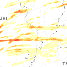
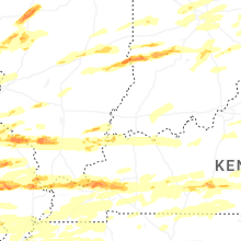
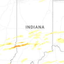
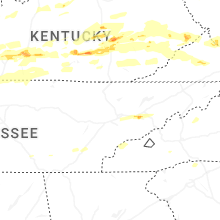
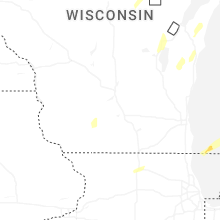
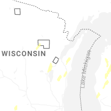
Hail Map for Friday, May 16, 2025

Number of Impacted Households on 5/16/2025
0
Impacted by 1" or Larger Hail
0
Impacted by 1.75" or Larger Hail
0
Impacted by 2.5" or Larger Hail
Square Miles of Populated Area Impacted on 5/16/2025
0
Impacted by 1" or Larger Hail
0
Impacted by 1.75" or Larger Hail
0
Impacted by 2.5" or Larger Hail


Cities Most Affected by Hail Storms of 5/16/2025
| Hail Size | Demographics of Zip Codes Affected | ||||||
|---|---|---|---|---|---|---|---|
| City | Count | Average | Largest | Pop Density | House Value | Income | Age |
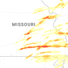
| Saint Charles, MO | 10 | 1.98 | 2.50 | 1053 | $141k | $66.3k | 39.1 |
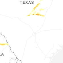
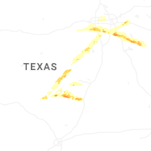
| Leander, TX | 8 | 2.28 | 3.00 | 379 | $111k | $57.3k | 33.2 |
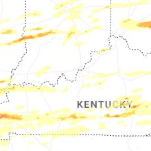
| Bowling Green, KY | 8 | 2.00 | 2.75 | 199 | $94k | $32.0k | 30.7 |
| Chesterfield, MO | 8 | 1.81 | 2.00 | 934 | $318k | $110.2k | 44.9 |
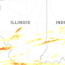
| Robinson, IL | 4 | 2.63 | 3.00 | 82 | $58k | $32.5k | 40.9 |
| Waynesville, MO | 4 | 2.56 | 3.25 | 200 | $90k | $37.7k | 31.8 |
| Sullivan, IN | 4 | 2.56 | 4.00 | 60 | $68k | $33.1k | 41.3 |
| Ava, MO | 5 | 1.95 | 2.75 | 18 | $55k | $25.9k | 44.4 |
| Saint Robert, MO | 3 | 2.92 | 4.00 | 433 | $0k | $0.0k | 29.8 |
| Saint Louis, MO | 4 | 2.00 | 2.50 | 4369 | $74k | $36.5k | 35.7 |
| Mountain View, MO | 3 | 2.00 | 2.50 | 32 | $61k | $23.0k | 41.6 |
| Bloomington, IN | 3 | 1.75 | 1.75 | 434 | $100k | $31.1k | 30.4 |
| Marthasville, MO | 3 | 1.75 | 1.75 | 35 | $111k | $50.7k | 41.6 |
| Wilmington, OH | 2 | 2.50 | 2.50 | 129 | $107k | $40.3k | 38.7 |
| Meridian, TX | 2 | 2.44 | 2.76 | 12 | $61k | $37.6k | 42.4 |
| Plato, MO | 2 | 2.25 | 2.50 | 12 | $80k | $30.1k | 36.7 |
| Willow Springs, MO | 2 | 2.13 | 2.50 | 24 | $52k | $22.5k | 40.8 |
| Barlow, KY | 1 | 4.00 | 4.00 | 22 | $46k | $29.4k | 40.5 |
| Saint Peters, MO | 2 | 2.00 | 2.00 | 1745 | $116k | $60.7k | 38.1 |
| Lost Creek, KY | 2 | 2.00 | 2.00 | 21 | $31k | $19.3k | 40.2 |
| Mc Kee, KY | 2 | 2.00 | 2.00 | 27 | $47k | $20.0k | 39.8 |
| Vanzant, MO | 2 | 1.88 | 2.00 | 8 | $68k | $32.1k | 50.6 |
| Jackson, KY | 1 | 2.75 | 2.75 | 27 | $48k | $19.4k | 39.7 |
| Spencer, IN | 1 | 2.75 | 2.75 | 76 | $90k | $37.4k | 42.4 |
| Mounds, IL | 1 | 2.75 | 2.75 | 52 | $26k | $23.3k | 39.8 |
| Villa Ridge, IL | 1 | 2.75 | 2.75 | 23 | $48k | $26.5k | 47.0 |
| Wickliffe, KY | 1 | 2.75 | 2.75 | 28 | $54k | $32.1k | 43.4 |
| Zalma, MO | 1 | 2.75 | 2.75 | 12 | $52k | $22.3k | 44.9 |
| Leesburg, OH | 1 | 2.50 | 2.50 | 58 | $86k | $40.3k | 34.6 |
| Upperco, MD | 1 | 2.50 | 2.50 | 105 | $181k | $63.6k | 47.7 |
| Trinidad, TX | 1 | 2.50 | 2.50 | 75 | $84k | $30.5k | 51.6 |
| Reyno, AR | 1 | 2.50 | 2.50 | 0 | $31k | $21.4k | 39.4 |
| Godley, TX | 1 | 2.50 | 2.50 | 33 | $77k | $45.8k | 37.8 |
| Van Buren, MO | 1 | 2.50 | 2.50 | 6 | $60k | $24.6k | 45.4 |
| Bellflower, MO | 1 | 2.00 | 2.00 | 16 | $42k | $35.9k | 43.2 |
| Smithland, KY | 1 | 2.00 | 2.00 | 16 | $61k | $31.0k | 44.8 |
| Malakoff, TX | 1 | 2.00 | 2.00 | 61 | $71k | $29.5k | 44.8 |
| Tyner, KY | 1 | 2.00 | 2.00 | 38 | $55k | $20.3k | 38.6 |
| Maynard, AR | 1 | 2.00 | 2.00 | 17 | $40k | $25.2k | 44.9 |
| Defiance, MO | 1 | 2.00 | 2.00 | 65 | $218k | $69.6k | 46.9 |
| Annville, KY | 1 | 2.00 | 2.00 | 52 | $45k | $21.1k | 39.5 |
| Calvert City, KY | 1 | 2.00 | 2.00 | 125 | $76k | $37.4k | 44.1 |
| Gerald, MO | 1 | 2.00 | 2.00 | 37 | $82k | $40.5k | 43.3 |
| Mouthcard, KY | 1 | 2.00 | 2.00 | 28 | $45k | $23.8k | 43.1 |
| Midlothian, TX | 1 | 2.00 | 2.00 | 318 | $112k | $60.9k | 35.6 |
| Ennis, TX | 1 | 2.00 | 2.00 | 104 | $73k | $41.1k | 33.7 |
| Hot Springs Village, AR | 1 | 2.00 | 2.00 | 223 | $145k | $44.6k | 65.9 |
| Laquey, MO | 1 | 2.00 | 2.00 | 19 | $82k | $25.0k | 38.9 |
| Oakland, KY | 1 | 2.00 | 2.00 | 38 | $84k | $40.4k | 42.0 |
| Washington Court House, OH | 1 | 2.00 | 2.00 | 105 | $87k | $36.1k | 39.6 |
| Avalon, NJ | 1 | 1.75 | 1.75 | 456 | $431k | $56.9k | 61.7 |
| Perryville, MO | 1 | 1.75 | 1.75 | 48 | $81k | $36.7k | 38.6 |
| Hurlock, MD | 1 | 1.75 | 1.75 | 104 | $84k | $39.1k | 40.2 |
| Russell Springs, KY | 1 | 1.75 | 1.75 | 77 | $61k | $21.8k | 40.7 |
| Clinton, AR | 1 | 1.75 | 1.75 | 22 | $61k | $24.7k | 44.4 |
| Farmington, MO | 1 | 1.75 | 1.75 | 112 | $85k | $32.4k | 39.5 |
| Corning, AR | 1 | 1.75 | 1.75 | 28 | $38k | $23.5k | 42.8 |
| Millsboro, DE | 1 | 1.75 | 1.75 | 325 | $110k | $34.8k | 48.4 |
| Pocahontas, AR | 1 | 1.75 | 1.75 | 44 | $57k | $29.2k | 41.5 |
| Rowdy, KY | 1 | 1.75 | 1.75 | 48 | $41k | $11.5k | 47.3 |
| Remus, MI | 1 | 1.75 | 1.75 | 33 | $69k | $34.8k | 41.3 |
| Red Bud, IL | 1 | 1.75 | 1.75 | 65 | $95k | $46.0k | 41.7 |
| Jewett, IL | 1 | 1.75 | 1.75 | 26 | $42k | $39.4k | 42.7 |
| Murphysboro, IL | 1 | 1.75 | 1.75 | 137 | $63k | $32.6k | 40.3 |
| Annapolis, MO | 1 | 1.75 | 1.75 | 8 | $46k | $23.8k | 42.3 |
| Lampasas, TX | 1 | 1.75 | 1.75 | 21 | $63k | $34.1k | 41.2 |
| Crowley, TX | 1 | 1.75 | 1.75 | 507 | $81k | $48.3k | 34.7 |
| Springfield, IL | 1 | 1.75 | 1.75 | 1989 | $64k | $31.8k | 33.3 |
| Lometa, TX | 1 | 1.75 | 1.75 | 5 | $40k | $32.0k | 43.3 |
| Effingham, IL | 1 | 1.75 | 1.75 | 187 | $93k | $39.2k | 40.1 |
| Cambria, IL | 1 | 1.75 | 1.75 | 0 | $51k | $13.8k | 38.8 |
| Paducah, KY | 1 | 1.75 | 1.75 | 391 | $94k | $37.7k | 42.2 |
| Alvarado, TX | 1 | 1.75 | 1.75 | 205 | $75k | $43.9k | 36.1 |
| Bonne Terre, MO | 1 | 1.75 | 1.75 | 116 | $76k | $36.0k | 38.3 |
| Danville, AR | 1 | 1.75 | 1.75 | 14 | $58k | $27.9k | 35.1 |
| Scott City, MO | 1 | 1.75 | 1.75 | 124 | $72k | $35.7k | 37.8 |
| Washington, MO | 1 | 1.75 | 1.75 | 265 | $114k | $48.4k | 41.1 |
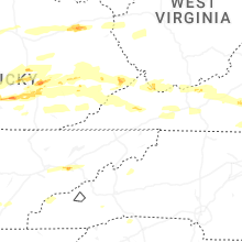
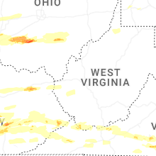
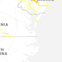
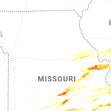
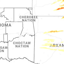
Hail and Wind Damage Spotted on 5/16/2025
Filter by Report Type:Hail ReportsWind Reports
States Impacted
Kentucky, Tennessee, Missouri, Arkansas, Pennsylvania, Michigan, Ohio, New Jersey, Virginia, West Virginia, Delaware, Maryland, Minnesota, Illinois, New York, Wisconsin, North Carolina, Indiana, TexasKentucky
| Local Time | Report Details |
|---|---|
| 8:00 AM EDT | Tree down on cartersville road near the county lin in garrard county KY, 24 miles WSW of Irvine, KY |
| 8:08 AM EDT | Quarter sized hail reported near Berea, KY, 20 miles WSW of Irvine, KY |
| 8:43 AM EDT | Quarter sized hail reported near Berea, KY, 22.4 miles WSW of Irvine, KY |
| 8:08 AM CDT | Ping Pong Ball sized hail reported near Morgantown, KY, 67.8 miles N of Nashville, TN |
| 8:20 AM CDT | Tree down on mercer rd near riversid in warren county KY, 67.4 miles N of Nashville, TN |
| 8:29 AM CDT | 1 tree down and small hai in edmonson county KY, 65.1 miles SW of Louisville, KY |
| 9:37 AM EDT | Quarter sized hail reported near Lawrenceburg, KY, 32.7 miles E of Louisville, KY, local business reported quarter size hail with picture to verify. |
| 9:44 AM EDT | Hen Egg sized hail reported near Tyner, KY, 24.5 miles S of Irvine, KY, social media photos of estimated 2 to 3 inch diameter hail from the tyner lake area of jackson county. |
| 9:48 AM EDT | Quarter sized hail reported near Lawrenceburg, KY, 43.5 miles E of Louisville, KY, report from mping: quarter (1.00 in.). |
| 9:51 AM EDT | Half Dollar sized hail reported near Lawrenceburg, KY, 43.5 miles E of Louisville, KY, report from mping: half dollar (1.25 in.). |
| 10:00 AM EDT | Hen Egg sized hail reported near Mc Kee, KY, 22.8 miles S of Irvine, KY, hail up to approximately egg size was reported along ky-290 between annville and mckee. event time estimated from radar. |
| 10:09 AM EDT | Tree down over the 600 block of coral ridge roa in bullitt county KY, 2.4 miles NNE of Louisville, KY |
| 10:10 AM EDT | Tree down over the 200 block of blue jay roa in bullitt county KY, 7.1 miles NNE of Louisville, KY |
| 10:20 AM EDT | Powerlines down on forecast av in taylor county KY, 48 miles SSE of Louisville, KY |
| 10:20 AM EDT | Tree... power pole and power lines down just north of north bypass and old lebanon r in taylor county KY, 47.3 miles SSE of Louisville, KY |
| 10:43 AM EDT | Tree down on the 400 block of sharp roa in casey county KY, 58.6 miles SE of Louisville, KY |
| 10:53 AM EDT | Quarter sized hail reported near Chavies, KY, 44.2 miles ESE of Irvine, KY, nickel to quarter-sized hail observed at the wendell h ford airport. |
| 10:54 AM EDT | Tree down on martins trail outside of mckinne in lincoln county KY, 46.4 miles WSW of Irvine, KY |
| 10:58 AM EDT | Golf Ball sized hail reported near Rowdy, KY, 46 miles ESE of Irvine, KY, emergency manager reported golf ball-sized hail along noble branch. |
| 10:58 AM EDT | Hen Egg sized hail reported near Lost Creek, KY, 43.2 miles ESE of Irvine, KY, photo shared via social media of multiple hail stones of at least 2 inch diameter. |
| 11:00 AM EDT | Hen Egg sized hail reported near Lost Creek, KY, 43.6 miles ESE of Irvine, KY, photo via social media of 2.00 to 2.50-inch diameter hail. time estimated from radar. |
| 10:30 AM CDT | Quarter sized hail reported near Cave City, KY, 64.8 miles S of Louisville, KY |
| 11:42 AM EDT | Quarter sized hail reported near Mount Vernon, KY, 35.3 miles SW of Irvine, KY, picture on social media shows approximately quarter-sized hail near wabd. time of occurrence estimated from radar. |
| 11:56 AM EDT | Two trees down blocking the road 1100 block of plum fork in maloneton... ky. time estimated via rada in greenup county KY, 73.1 miles WNW of Charleston, WV |
| 11:57 AM EDT | County dispatch reported a tree blown down and partially blocking ky-203 in floyd county KY, 68.6 miles NNW of Bristol, TN |
| 12:02 PM EDT | Hen Egg sized hail reported near Mc Kee, KY, 16.2 miles SSW of Irvine, KY, picture on social media showed approximately egg-size hail. time of occurrence estimated from radar. |
| 12:15 PM EDT | Half Dollar sized hail reported near Elkhorn City, KY, 49.3 miles N of Bristol, TN, hail fell from 12:15 to 12:20 pm. photo provided to the office. |
| 12:46 PM EDT | Tree blocking road near 200 old bronston school roa in pulaski county KY, 61.7 miles SW of Irvine, KY |
| 12:48 PM EDT | Trees and power lines down along ky highway 3106 and ky highway 1275 n between monticello and steubenville. exact location estimate in wayne county KY, 72 miles SW of Irvine, KY |
| 12:49 PM EDT | Several trees down blocking close roa in pulaski county KY, 50.7 miles SSW of Irvine, KY |
| 12:49 PM EDT | Tree down on roa in pulaski county KY, 49.5 miles SSW of Irvine, KY |
| 12:51 PM EDT | Couple of trees down blocking the road near the intersection of clay hill road and kettlehead roa in pulaski county KY, 52.5 miles SSW of Irvine, KY |
| 1:01 PM EDT | Hen Egg sized hail reported near Annville, KY, 27 miles S of Irvine, KY, time of occurrence estimated from radar. |
| 1:03 PM EDT | Roof peeled off a business onto multiple adjacent vehicles. vehicles have sustained unspecified damag in laurel county KY, 39.8 miles S of Irvine, KY |
| 1:03 PM EDT | Multiple photos of large tree snapped and split three ways and blocking the intersection of whitley street and jody street in london. power pole snapped and power lines in laurel county KY, 40.5 miles S of Irvine, KY |
| 1:03 PM EDT | Baseball sized hail reported near Jackson, KY, 38.5 miles ESE of Irvine, KY, photos of two hailstones with diameter greater than 2 inches. largest stone appears to be 2.75 inches or larger. |
| 1:07 PM EDT | A spotter in southeast london noted that trees were downed along barrett road as the storms moved through. time estimated by rada in laurel county KY, 41 miles S of Irvine, KY |
| 1:08 PM EDT | A couple of trees down near the intersection of sasser school road and shields lan in laurel county KY, 41.6 miles S of Irvine, KY |
| 1:08 PM EDT | Tree down and blocking moores creek school road. time estimated from rada in jackson county KY, 30.4 miles S of Irvine, KY |
| 1:09 PM EDT | Trees were reported to have been blown down near bush elementary school along ky 80 in eastern laurel county with a picture relayed by a ham radio operator. the event t in laurel county KY, 40.8 miles S of Irvine, KY |
| 1:12 PM EDT | Hen Egg sized hail reported near Mouthcard, KY, 55.7 miles N of Bristol, TN, report via the pike county em. |
| 1:16 PM EDT | Several trees down in the curry branch rd and ky highway 80 are in clay county KY, 41.7 miles SSE of Irvine, KY |
| 1:18 PM EDT | A couple of trees down in the sublimity springs subdivisio in laurel county KY, 43.9 miles S of Irvine, KY |
| 1:20 PM EDT | Trees down between the 400 and 500 block of lick branch roa in pike county KY, 58.2 miles NNW of Bristol, TN |
| 1:20 PM EDT | Multiple trees down along bar creek rd. time estimated from rada in clay county KY, 37.6 miles SSE of Irvine, KY |
| 1:21 PM EDT | Trees down on east shelbiana road between petyon creek and greesy creek roa in pike county KY, 58.6 miles NNW of Bristol, TN |
| 1:23 PM EDT | Tree down on power line. time estimated from radar. possible that damage was caused by subsequent storm about 30 minutes late in knox county KY, 48.2 miles S of Irvine, KY |
| 1:26 PM EDT | Several trees reported down in the otter creek rd and goose creek rd area in clay county KY, 47.7 miles SSE of Irvine, KY |
| 1:26 PM EDT | In or near whick along ky 1110 trees and powerlines were reported to have been blown down. the event time is radar estimate in breathitt county KY, 37.9 miles ESE of Irvine, KY |
| 1:29 PM EDT | Trees down in the big creek area and power line down on hal rogers parkway near mile marker 2 in clay county KY, 43.4 miles SSE of Irvine, KY |
| 1:50 PM EDT | County dispatch reported a tree bringing down power lines onto a residence in the 2600 block of big creek road. time of occurrence estimated from rada in perry county KY, 53.1 miles SE of Irvine, KY |
| 1:54 PM EDT | State police reported a tree knocked down onto ky-7 in the vicinity of cornettsville. time of event occurrence estimated from rada in perry county KY, 60.3 miles NW of Bristol, TN |
| 1:58 PM EDT | Power pole blown down... leaving power lines on a residence and transformer on a driveway in the 2000 block of ky-463. time of occurrence estimated from rada in perry county KY, 57.8 miles WNW of Bristol, TN |
| 2:00 PM EDT | At least ten reports of trees down with power outages throughout the county and impacting most major thoroughfares... including us highway 421 and ky highway 80. radar in leslie county KY, 49.9 miles SE of Irvine, KY |
| 2:13 PM EDT | Pike county dispatch reported a tree blown down and partially blocking hurricane road in the 4400 block. time of occurrence estimated from rada in pike county KY, 65.9 miles NNW of Bristol, TN |
| 2:15 PM EDT | State police reported a tree blown down near the millstone communit in letcher county KY, 49.5 miles NW of Bristol, TN |
| 2:21 PM EDT | Pike county dispatch reported a tree blown down and blocking raccoon road in the 6500 block. road was closed. time of occurrence estimated from rada in pike county KY, 62.1 miles N of Bristol, TN |
| 2:22 PM EDT | Pike county dispatch reported a tree hanging over and partially blocking east shelbiana road in the 4000 block. event occurrence time estimated from rada in pike county KY, 58.7 miles NNW of Bristol, TN |
| 2:33 PM EDT | Pike county dispatch reported a utility line knocked down onto a roof and a power pole blown over in the 3000 block of fedscreek road. time of occurrence estimated from in pike county KY, 55.7 miles N of Bristol, TN |
| 4:44 PM CDT | Baseball sized hail reported near Wickliffe, KY, 33.1 miles SE of Cape Girardeau, MO |
| 4:54 PM CDT | Quarter sized hail reported near West Paducah, KY, 43.9 miles ESE of Cape Girardeau, MO, report from mping: quarter (1.00 in.). |
| 4:55 PM CDT | Ping Pong Ball sized hail reported near West Paducah, KY, 43.9 miles ESE of Cape Girardeau, MO, report from mping: ping pong ball (1.50 in.). |
| 4:58 PM CDT | Grapefruit sized hail reported near Barlow, KY, 32.8 miles ESE of Cape Girardeau, MO, reports of windows busted out from hail. |
| 5:02 PM CDT | Half Dollar sized hail reported near West Paducah, KY, 45.6 miles ESE of Cape Girardeau, MO |
| 5:09 PM CDT | 1 inch hail and power lines/power poles broke across the road at the ema offic in mccracken county KY, 50.4 miles ESE of Cape Girardeau, MO |
| 5:11 PM CDT | Golf Ball sized hail reported near Paducah, KY, 52 miles ESE of Cape Girardeau, MO |
| 5:32 PM CDT | Hen Egg sized hail reported near Calvert City, KY, 62.6 miles N of Mc Kenzie, TN |
| 5:44 PM CDT | Quarter sized hail reported near Kuttawa, KY, 68.5 miles NNE of Mc Kenzie, TN |
| 5:57 PM CDT | Hen Egg sized hail reported near Smithland, KY, 64.1 miles E of Cape Girardeau, MO |
| 6:55 PM CDT | Half Dollar sized hail reported near Lewisburg, KY, 57.5 miles N of Nashville, TN, report from mping: half dollar (1.25 in.). |
| 7:06 PM CDT | Trees snapped power lines dow in todd county KY, 58 miles NNW of Nashville, TN |
| 7:28 PM CDT | Quarter sized hail reported near Bowling Green, KY, 62.2 miles N of Nashville, TN |
| 8:36 PM EDT | Quarter sized hail reported near Lawrenceburg, KY, 43.5 miles E of Louisville, KY |
| 7:39 PM CDT | Baseball sized hail reported near Bowling Green, KY, 56.6 miles NNE of Nashville, TN, picture on x. |
| 7:40 PM CDT | Half Dollar sized hail reported near Bowling Green, KY, 59.4 miles NNE of Nashville, TN |
| 7:41 PM CDT | Ping Pong Ball sized hail reported near Bowling Green, KY, 60.4 miles NNE of Nashville, TN |
| 7:42 PM CDT | Power lines down and possible gas leak near us 60 morganfiel in union county KY, 27.8 miles SW of Evansville, IN |
| 7:42 PM CDT | Quarter sized hail reported near Bowling Green, KY, 58.4 miles NNE of Nashville, TN, report from mping: quarter (1.00 in.). |
| 7:42 PM CDT | Quarter sized hail reported near Bowling Green, KY, 60.4 miles NNE of Nashville, TN, report from mping: quarter (1.00 in.). |
| 7:42 PM CDT | Golf Ball sized hail reported near Bowling Green, KY, 60.4 miles NNE of Nashville, TN, picture on twitter. |
| 7:46 PM CDT | Quarter sized hail reported near Bowling Green, KY, 59.6 miles NNE of Nashville, TN |
| 7:46 PM CDT | Golf Ball sized hail reported near Bowling Green, KY, 64.9 miles NNE of Nashville, TN, report from mping: golf ball (1.75 in.). |
| 7:46 PM CDT | Hen Egg sized hail reported near Bowling Green, KY, 64.9 miles NNE of Nashville, TN, report from mping: hen egg (2.00 in.). |
| 7:46 PM CDT | Tennis Ball sized hail reported near Bowling Green, KY, 62.8 miles NNE of Nashville, TN, report from mping: tennis ball (2.50 in.). |
| 7:47 PM CDT | Golf Ball sized hail reported near Bowling Green, KY, 64 miles NNE of Nashville, TN, report from mping: golf ball (1.75 in.). |
| 7:48 PM CDT | Golf Ball sized hail reported near Bowling Green, KY, 63.2 miles NNE of Nashville, TN, picture on x. |
| 7:48 PM CDT | Golf Ball sized hail reported near Bowling Green, KY, 61.1 miles NNE of Nashville, TN, picture on x. |
| 7:49 PM CDT | Quarter sized hail reported near Bowling Green, KY, 62.8 miles NNE of Nashville, TN |
| 7:54 PM CDT | Hen Egg sized hail reported near Oakland, KY, 66.9 miles NNE of Nashville, TN, picture on x. |
| 8:12 PM CDT | Tree down at the intersection of old happy valley road and happy valley roa in barren county KY, 62.8 miles SSW of Louisville, KY |
| 8:17 PM CDT | Quarter sized hail reported near Owensboro, KY, 28.5 miles ESE of Evansville, IN |
| 8:24 PM CDT | Roof off building in downtown princeto in caldwell county KY, 62.3 miles SSW of Evansville, IN |
| 8:24 PM CDT | Tree down on a powerline on the 1000 block of state route 271 sout in hancock county KY, 42 miles E of Evansville, IN |
| 8:30 PM CDT | Mesonet station prnc princeton ky 2 s in caldwell county KY, 62.6 miles SSW of Evansville, IN |
| 8:38 PM CDT | Large tree down on the 9200 block of state route 6 in hancock county KY, 45.2 miles ESE of Evansville, IN |
| 8:39 PM CDT | Tree down on the 7200 block of state route 6 in hancock county KY, 45.6 miles ESE of Evansville, IN |
| 8:42 PM CDT | Tree on a hous in fulton county KY, 48 miles NW of Mc Kenzie, TN |
| 8:46 PM CDT | Quarter sized hail reported near Mayfield, KY, 32 miles N of Mc Kenzie, TN, report from mping: quarter (1.00 in.). |
| 9:47 PM EDT | Tree down over the intersection of rhodelia road and roy hardesty roa in meade county KY, 36.4 miles W of Louisville, KY |
| 8:49 PM CDT | Trees and power lines down in the city of mayfiel in graves county KY, 42.4 miles N of Mc Kenzie, TN |
| 9:50 PM EDT | Tree down over the intersection of new state road and highway 37 in meade county KY, 35.1 miles W of Louisville, KY |
| 8:55 PM CDT | On hwy 80 at the graves/calloway county line. power flashes see in graves county KY, 37.1 miles N of Mc Kenzie, TN |
| 8:58 PM CDT | 61 kt measured at murray aipor in calloway county KY, 37.3 miles NNE of Mc Kenzie, TN |
| 10:03 PM EDT | Trained spotter called to report two trees were down near the intersection of majestic dr and cr-1446. time estimated from rada in estill county KY, 5.3 miles W of Irvine, KY |
| 10:06 PM EDT | Large tree down at the intersection of dave smith road and sunny lan in meade county KY, 23.7 miles WSW of Louisville, KY |
| 10:06 PM EDT | Tree down over cupio lan in bullitt county KY, 8.4 miles W of Louisville, KY |
| 10:06 PM EDT | Storm damage reported in jefferson county KY, 12.6 miles N of Louisville, KY |
| 10:08 PM EDT | Tree down over the 200 block of east martin plac in bullitt county KY, 4.3 miles WNW of Louisville, KY |
| 9:09 PM CDT | Several trees down across the count in muhlenberg county KY, 57.6 miles SSE of Evansville, IN |
| 10:10 PM EDT | Tree down over the 3500 block of preston highwa in bullitt county KY, 3.4 miles SSE of Louisville, KY |
| 10:10 PM EDT | Tree down on the 2500 block of bells mill roa in bullitt county KY, 5.1 miles NE of Louisville, KY |
| 10:12 PM EDT | Tree down over the 200 block of bardstown roa in bullitt county KY, 10.6 miles ENE of Louisville, KY |
| 10:15 PM EDT | Tree down over hubbard lan in bullitt county KY, 11.6 miles ENE of Louisville, KY |
| 9:17 PM CDT | A few trees down and large limbs down at intersection of union hill rd and murray highwa in marshall county KY, 46.9 miles NNE of Mc Kenzie, TN |
| 9:23 PM CDT | Golf Ball sized hail reported near Russell Springs, KY, 72.7 miles SSE of Louisville, KY |
| 10:25 PM EDT | Corrects previous tstm wnd dmg report from 1 ene mount washington. multiple power poles snapped near bullitt east high schoo in bullitt county KY, 11.3 miles ENE of Louisville, KY |
| 10:30 PM EDT | Spencer county mesone in spencer county KY, 22.3 miles E of Louisville, KY |
| 10:30 PM EDT | Hardin county mesone in hardin county KY, 25.7 miles SW of Louisville, KY |
| 10:30 PM EDT | Storm damage reported in hardin county KY, 25.9 miles SW of Louisville, KY |
| 10:30 PM EDT | Storm damage reported in spencer county KY, 20.7 miles E of Louisville, KY |
| 9:32 PM CDT | Quarter sized hail reported near Russell Springs, KY, 71.2 miles SW of Irvine, KY, report from mping: quarter (1.00 in.). |
| 9:32 PM CDT | Quarter sized hail reported near Russell Springs, KY, 70.3 miles SW of Irvine, KY, report from mping: quarter (1.00 in.). |
| 10:35 PM EDT | Multiple power poles snapped near bullitt east high schoo in bullitt county KY, 11.3 miles ENE of Louisville, KY |
| 9:41 PM CDT | Quarter sized hail reported near Oak Grove, KY, 50.2 miles NW of Nashville, TN |
| 9:47 PM CDT | Power lines down blocking the roa in christian county KY, 60.6 miles NW of Nashville, TN |
| 9:50 PM CDT | Mesonet station zion elkton ky 5 s in todd county KY, 47.4 miles NNW of Nashville, TN |
| 10:55 PM EDT | Storm damage reported in marion county KY, 30.4 miles SE of Louisville, KY |
| 10:58 PM EDT | Several trees down around olive hill. time estimated by rada in carter county KY, 60.3 miles NE of Irvine, KY |
| 10:00 PM CDT | Mesonet station 1578w logan aluminu in logan county KY, 54 miles N of Nashville, TN |
| 11:00 PM EDT | Large hardwood tree spli in campbell county KY, 13 miles SE of Cincinnati, OH |
| 10:07 PM CDT | 4 trees blown over and uprooted on london driv in warren county KY, 52 miles NNE of Nashville, TN |
| 11:10 PM EDT | Storm damage reported in fayette county KY, 41.9 miles NW of Irvine, KY |
| 10:17 PM CDT | Corrects previous tstm wnd gst report from 1 ese bowling gree in warren county KY, 58.1 miles NNE of Nashville, TN |
| 10:17 PM CDT | Storm damage reported in warren county KY, 58.1 miles NNE of Nashville, TN |
| 10:19 PM CDT | Storm damage reported in warren county KY, 48.2 miles NNE of Nashville, TN |
| 11:26 PM EDT | Tree down. time estimated by rada in boyd county KY, 55.2 miles W of Charleston, WV |
| 10:30 PM CDT | Storm damage reported in barren county KY, 68.1 miles NNE of Nashville, TN |
| 11:36 PM EDT | Tree down over the 200 block of lexington roa in garrard county KY, 33.6 miles W of Irvine, KY |
| 11:36 PM EDT | Tree down on a home on the 100 block of york stree in garrard county KY, 33.6 miles W of Irvine, KY |
| 11:36 PM EDT | Tree down over the 100 block of kelly ridge roa in garrard county KY, 28.7 miles W of Irvine, KY |
| 11:40 PM EDT | Tree down over the 4100 block of preachersville road blocking two lane in lincoln county KY, 33.7 miles WSW of Irvine, KY |
| 11:49 PM EDT | A tree blew down on hampton wa in madison county KY, 19.6 miles W of Irvine, KY |
| 11:55 PM EDT | Storm damage reported in madison county KY, 20.1 miles WSW of Irvine, KY |
| 11:05 PM CDT | Storm damage reported in cumberland county KY, 84.2 miles S of Louisville, KY |
Tennessee
| Local Time | Report Details |
|---|---|
| 7:32 AM CDT | Quarter sized hail reported near Tiptonville, TN, 56.1 miles WNW of Mc Kenzie, TN, reported quarter size hail in tiptonville... tn. |
| 8:30 AM CDT | Quarter sized hail reported near Ridgely, TN, 54.4 miles W of Mc Kenzie, TN |
| 9:23 AM CDT | Trees down at palestine road and herrondale east roa in henry county TN, 9.8 miles NE of Mc Kenzie, TN |
| 9:26 AM CDT | Tree down across van dyke road at routon lan in henry county TN, 10.7 miles NE of Mc Kenzie, TN |
| 9:36 PM CDT | Tree down on shady grove roa in henry county TN, 23.1 miles NE of Mc Kenzie, TN |
| 9:45 PM CDT | Tree down near old paris murray road and chapel hill roa in henry county TN, 20.1 miles NE of Mc Kenzie, TN |
| 9:48 PM CDT | Tree down through powerlines on brown street in pari in henry county TN, 15.2 miles NE of Mc Kenzie, TN |
| 9:52 PM CDT | Report of trees down near fairgrounds road and hummingbird lane in pari in henry county TN, 18.5 miles NE of Mc Kenzie, TN |
| 9:58 PM CDT | Tree down on highway 49 at overlook rd. time estimated based on rada in stewart county TN, 47.4 miles ENE of Mc Kenzie, TN |
| 10:10 PM CDT | Multiple reports of trees and powerlines down across the county. 1 home with a tree on it. time estimated by rada in montgomery county TN, 41.8 miles NW of Nashville, TN |
| 10:11 PM CDT | Tree down on highway 149 in cumberland city. time estimated based on rada in stewart county TN, 49.9 miles WNW of Nashville, TN |
| 10:27 PM CDT | Several trees down across robertson count in robertson county TN, 25.2 miles NNW of Nashville, TN |
| 10:46 PM CDT | Half Dollar sized hail reported near Pleasant View, TN, 19.7 miles NW of Nashville, TN, report from mping: half dollar (1.25 in.). |
| 10:48 PM CDT | Quarter sized hail reported near Pleasant View, TN, 19.7 miles NW of Nashville, TN, report from mping: quarter (1.00 in.). |
| 10:51 PM CDT | Report of trees down along shades bridge roa in weakley county TN, 12.4 miles W of Mc Kenzie, TN |
| 10:57 PM CDT | Facebook report of a tree down on south tunnel r in sumner county TN, 28.3 miles NE of Nashville, TN |
| 11:12 PM CDT | Quarter sized hail reported near Mc Kenzie, TN, 0.7 miles NE of Mc Kenzie, TN, report of quarter size hail in mckenzie. |
| 1:28 AM EDT | Trees dow in scott county TN, 50.6 miles NW of Knoxville, TN |
| 1:48 AM EDT | High wind with trees dow in campbell county TN, 30 miles NNW of Knoxville, TN |
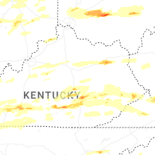
Missouri
| Local Time | Report Details |
|---|---|
| 7:35 AM CDT | Quarter sized hail reported near Hornersville, MO, 61.5 miles N of Memphis, TN, time estimated on radar. |
| 12:28 PM CDT | Quarter sized hail reported near Marshfield, MO, 23.4 miles ENE of Springfield, MO |
| 12:30 PM CDT | Golf Ball sized hail reported near Ava, MO, 35.4 miles SE of Springfield, MO, report from mping... golf ball 1.75 in. |
| 12:42 PM CDT | Golf Ball sized hail reported near Ava, MO, 41.6 miles ESE of Springfield, MO |
| 12:42 PM CDT | Baseball sized hail reported near Ava, MO, 39.2 miles ESE of Springfield, MO |
| 12:43 PM CDT | Quarter sized hail reported near Ava, MO, 37.8 miles ESE of Springfield, MO |
| 12:43 PM CDT | Golf Ball sized hail reported near Ava, MO, 39.2 miles ESE of Springfield, MO |
| 12:45 PM CDT | Quarter sized hail reported near Ava, MO, 43.2 miles SE of Springfield, MO |
| 12:50 PM CDT | Golf Ball sized hail reported near Ava, MO, 38.4 miles ESE of Springfield, MO |
| 1:00 PM CDT | Hen Egg sized hail reported near Laquey, MO, 43.4 miles WNW of Salem, MO, sizes range from penny to lime size if not bigger. happened for 20 straight mins and lots of damage to vehicles. |
| 1:00 PM CDT | Hen Egg sized hail reported near Vanzant, MO, 57.2 miles ESE of Springfield, MO, pictures sent. |
| 1:00 PM CDT | Quarter sized hail reported near Mountain Grove, MO, 52.1 miles SW of Salem, MO, report from mping... quarter 1.00 in. |
| 1:00 PM CDT | Golf Ball sized hail reported near Vanzant, MO, 57.2 miles ESE of Springfield, MO |
| 1:05 PM CDT | Hen Egg sized hail reported near Waynesville, MO, 39.9 miles WNW of Salem, MO, mixture of hail sizes with the largest 2 inches. |
| 1:05 PM CDT | Tea Cup sized hail reported near Waynesville, MO, 38.8 miles WNW of Salem, MO, report from mping... baseball 3.25 in. |
| 1:09 PM CDT | Tea Cup sized hail reported near Saint Robert, MO, 37.7 miles WNW of Salem, MO, corrects previous hail report from saint robert. via social media post and picture. corrected size. |
| 1:09 PM CDT | Grapefruit sized hail reported near Saint Robert, MO, 37.7 miles WNW of Salem, MO, via social media post and picture. |
| 1:10 PM CDT | Ping Pong Ball sized hail reported near Saint Robert, MO, 32.6 miles WNW of Salem, MO, report from mping ping pong ball 1.50 in. |
| 1:10 PM CDT | Golf Ball sized hail reported near Saint Robert, MO, 33.9 miles WNW of Salem, MO, report from mping... golf ball 1.75 in. |
| 1:10 PM CDT | Tea Cup sized hail reported near Waynesville, MO, 39.6 miles WNW of Salem, MO, picture of 3 inch hail. |
| 1:10 PM CDT | Hen Egg sized hail reported near Waynesville, MO, 38.8 miles WNW of Salem, MO, via social media picture. |
| 1:12 PM CDT | Tennis Ball sized hail reported near Plato, MO, 38.7 miles WSW of Salem, MO, picture of 2.5 inch hail. |
| 1:15 PM CDT | Hen Egg sized hail reported near Plato, MO, 34.1 miles WSW of Salem, MO |
| 1:15 PM CDT | Ping Pong Ball sized hail reported near Saint Robert, MO, 34.9 miles WNW of Salem, MO |
| 1:25 PM CDT | Tennis Ball sized hail reported near Willow Springs, MO, 50.6 miles SSW of Salem, MO, almost tennis ball size hail. |
| 1:26 PM CDT | Golf Ball sized hail reported near Willow Springs, MO, 50.6 miles SSW of Salem, MO |
| 1:30 PM CDT | Quarter sized hail reported near Saint James, MO, 35.3 miles NNW of Salem, MO, report from mping... quarter 1.00 in. |
| 1:36 PM CDT | Golf Ball sized hail reported near Mountain View, MO, 46 miles SSW of Salem, MO |
| 1:37 PM CDT | Ping Pong Ball sized hail reported near New Haven, MO, 55.4 miles W of Saint Louis, MO |
| 1:38 PM CDT | Golf Ball sized hail reported near Mountain View, MO, 45.9 miles SSW of Salem, MO |
| 1:41 PM CDT | Quarter sized hail reported near New Haven, MO, 53.1 miles W of Saint Louis, MO |
| 1:43 PM CDT | Quarter sized hail reported near New Haven, MO, 53.1 miles W of Saint Louis, MO, report from mping: quarter (1.00 in.). |
| 1:44 PM CDT | Quarter sized hail reported near Marthasville, MO, 50.9 miles W of Saint Louis, MO, report from mping: quarter (1.00 in.). |
| 1:45 PM CDT | Hen Egg sized hail reported near Bellflower, MO, 53.1 miles E of Columbia, MO, emergency management relayed a photo of large hail. time estimated by radar. |
| 1:47 PM CDT | Quarter sized hail reported near New Haven, MO, 55.2 miles W of Saint Louis, MO, report from mping: quarter (1.00 in.). |
| 1:48 PM CDT | Tennis Ball sized hail reported near Mountain View, MO, 42.8 miles SSW of Salem, MO, media relayed pic of lemon sized hail. |
| 1:50 PM CDT | Golf Ball sized hail reported near Marthasville, MO, 46.6 miles W of Saint Louis, MO, warren county em reported golf ball sized hail at marthasville. |
| 1:51 PM CDT | Golf Ball sized hail reported near Marthasville, MO, 43.4 miles W of Saint Louis, MO |
| 1:52 PM CDT | Golf Ball sized hail reported near Marthasville, MO, 42.8 miles W of Saint Louis, MO |
| 1:53 PM CDT | Hen Egg sized hail reported near Gerald, MO, 53.8 miles NNE of Salem, MO, video sent in by local broadcast media. courtesy of ksdk. time estimated by radar. |
| 2:00 PM CDT | Quarter sized hail reported near Defiance, MO, 35.9 miles W of Saint Louis, MO, report from mping: quarter (1.00 in.). |
| 2:00 PM CDT | Quarter sized hail reported near Wentzville, MO, 37.2 miles W of Saint Louis, MO, time estimated. |
| 2:05 PM CDT | Quarter sized hail reported near Washington, MO, 44.2 miles W of Saint Louis, MO |
| 2:05 PM CDT | Half Dollar sized hail reported near Washington, MO, 44.2 miles W of Saint Louis, MO, washington school district official submitted a photo of half dollar size hail. time estimated by radar. |
| 2:05 PM CDT | Quarter sized hail reported near Washington, MO, 44.7 miles W of Saint Louis, MO, washington em reported 1-inch hail. |
| 2:06 PM CDT | Quarter sized hail reported near Washington, MO, 44.1 miles W of Saint Louis, MO |
| 2:07 PM CDT | Quarter sized hail reported near O Fallon, MO, 29.3 miles WNW of Saint Louis, MO, time estimated. |
| 2:07 PM CDT | Golf Ball sized hail reported near Washington, MO, 44.2 miles W of Saint Louis, MO, report from mping: golf ball (1.75 in.). |
| 2:10 PM CDT | 12 power poles down near highway n and money driv in st. charles county MO, 30.1 miles WNW of Saint Louis, MO |
| 2:10 PM CDT | Power lines down near highway n between highway k and bryan roa in st. charles county MO, 29.6 miles WNW of Saint Louis, MO |
| 2:12 PM CDT | Quarter sized hail reported near West Plains, MO, 73.3 miles SSW of Salem, MO |
| 2:12 PM CDT | Half Dollar sized hail reported near O Fallon, MO, 29.3 miles WNW of Saint Louis, MO, report from mping: half dollar (1.25 in.). |
| 2:13 PM CDT | Hen Egg sized hail reported near Defiance, MO, 31.4 miles W of Saint Louis, MO |
| 2:15 PM CDT | 4 power poles snapped/down... cutting off the entrance/exit to a neighborhood. time estimated from rada in st. charles county MO, 29.6 miles WNW of Saint Louis, MO |
| 2:18 PM CDT | Hen Egg sized hail reported near Saint Charles, MO, 26.5 miles W of Saint Louis, MO, hail persisted for 10+ minutes. |
| 2:18 PM CDT | Quarter sized hail reported near Chesterfield, MO, 26.5 miles W of Saint Louis, MO, report from mping: quarter (1.00 in.). |
| 2:18 PM CDT | Ping Pong Ball sized hail reported near Chesterfield, MO, 26.5 miles W of Saint Louis, MO, report from mping: ping pong ball (1.50 in.). |
| 2:18 PM CDT | Hen Egg sized hail reported near Saint Charles, MO, 26.6 miles WNW of Saint Louis, MO |
| 2:18 PM CDT | Quarter sized hail reported near O Fallon, MO, 29.8 miles WNW of Saint Louis, MO, report from mping: quarter (1.00 in.). |
| 2:18 PM CDT | Several power lines downe in st. charles county MO, 30.1 miles WNW of Saint Louis, MO |
| 2:19 PM CDT | Golf Ball sized hail reported near Chesterfield, MO, 26.5 miles W of Saint Louis, MO, report from mping: golf ball (1.75 in.). |
| 2:20 PM CDT | Golf Ball sized hail reported near Chesterfield, MO, 26.5 miles W of Saint Louis, MO, report from mping: golf ball (1.75 in.). |
| 2:20 PM CDT | Howell county eoc showed peak wind gusts at 67.6 mph during as the storms passed through west plain in howell county MO, 64.5 miles SSW of Salem, MO |
| 2:20 PM CDT | Hen Egg sized hail reported near Saint Charles, MO, 22 miles WNW of Saint Louis, MO |
| 2:20 PM CDT | Tree top down... two trees uproote in howell county MO, 65 miles SSW of Salem, MO |
| 2:20 PM CDT | Quarter sized hail reported near Saint Peters, MO, 24.1 miles WNW of Saint Louis, MO, time estimated. |
| 2:20 PM CDT | Ping Pong Ball sized hail reported near Saint Charles, MO, 25.2 miles WNW of Saint Louis, MO, time estimated. |
| 2:21 PM CDT | Quarter sized hail reported near Saint Peters, MO, 26.5 miles WNW of Saint Louis, MO, report from mping: quarter (1.00 in.). |
| 2:21 PM CDT | Quarter sized hail reported near Saint Peters, MO, 25 miles WNW of Saint Louis, MO, report from mping: quarter (1.00 in.). |
| 2:21 PM CDT | Quarter sized hail reported near Chesterfield, MO, 26.5 miles W of Saint Louis, MO, report from mping: quarter (1.00 in.). |
| 2:22 PM CDT | Quarter sized hail reported near Chesterfield, MO, 26.5 miles W of Saint Louis, MO, report from mping: quarter (1.00 in.). |
| 2:23 PM CDT | Quarter sized hail reported near West Plains, MO, 66.5 miles SSW of Salem, MO, report from mping... quarter 1.00 in. |
| 2:23 PM CDT | Golf Ball sized hail reported near Chesterfield, MO, 24.5 miles W of Saint Louis, MO, report from mping: golf ball (1.75 in.). |
| 2:23 PM CDT | Half Dollar sized hail reported near Saint Charles, MO, 26.9 miles WNW of Saint Louis, MO |
| 2:24 PM CDT | Golf Ball sized hail reported near Saint Charles, MO, 23.5 miles WNW of Saint Louis, MO |
| 2:24 PM CDT | Hen Egg sized hail reported near Saint Charles, MO, 25.4 miles WNW of Saint Louis, MO |
| 2:24 PM CDT | Hen Egg sized hail reported near Chesterfield, MO, 19.6 miles W of Saint Louis, MO, city of chesterfield official submitted a photo of 2 inch hail. |
| 2:24 PM CDT | Ping Pong Ball sized hail reported near Saint Peters, MO, 24.5 miles WNW of Saint Louis, MO, photo submitted courtesy of spectrum news. |
| 2:24 PM CDT | Golf Ball sized hail reported near Chesterfield, MO, 21.2 miles W of Saint Louis, MO, report from mping: golf ball (1.75 in.). |
| 2:24 PM CDT | Half Dollar sized hail reported near Saint Charles, MO, 24.3 miles WNW of Saint Louis, MO, 60 mph estimated winds as well. |
| 2:24 PM CDT | Golf Ball sized hail reported near Chesterfield, MO, 24.5 miles W of Saint Louis, MO |
| 2:25 PM CDT | Hen Egg sized hail reported near Saint Peters, MO, 22.2 miles WNW of Saint Louis, MO |
| 2:25 PM CDT | Half Dollar sized hail reported near Saint Peters, MO, 23.3 miles WNW of Saint Louis, MO, report from mping: half dollar (1.25 in.). |
| 2:25 PM CDT | Half Dollar sized hail reported near Saint Charles, MO, 22.8 miles WNW of Saint Louis, MO, report from mping: half dollar (1.25 in.). |
| 2:25 PM CDT | Tennis Ball sized hail reported near Saint Charles, MO, 24 miles WNW of Saint Louis, MO, report from mping: tennis ball (2.50 in.). |
| 2:25 PM CDT | Hen Egg sized hail reported near Saint Charles, MO, 25.8 miles WNW of Saint Louis, MO, photo submitted via social media. |
| 2:25 PM CDT | Golf Ball sized hail reported near Saint Charles, MO, 23.5 miles WNW of Saint Louis, MO, picture received on x. time estimated from radar. |
| 2:26 PM CDT | Hen Egg sized hail reported near Saint Peters, MO, 23 miles WNW of Saint Louis, MO, report from mping: hen egg (2.00 in.). |
| 2:26 PM CDT | Half Dollar sized hail reported near Chesterfield, MO, 24.4 miles W of Saint Louis, MO, report from mping: half dollar (1.25 in.). |
| 2:26 PM CDT | Hen Egg sized hail reported near Chesterfield, MO, 18.6 miles W of Saint Louis, MO |
| 2:27 PM CDT | Golf Ball sized hail reported near Chesterfield, MO, 18.6 miles W of Saint Louis, MO, report from mping: golf ball (1.75 in.). |
| 2:27 PM CDT | Golf Ball sized hail reported near Saint Charles, MO, 24 miles WNW of Saint Louis, MO, report from mping: golf ball (1.75 in.). |
| 2:27 PM CDT | Ping Pong Ball sized hail reported near Saint Peters, MO, 24.1 miles WNW of Saint Louis, MO |
| 2:29 PM CDT | Quarter sized hail reported near Chesterfield, MO, 19.1 miles W of Saint Louis, MO |
| 2:29 PM CDT | Quarter sized hail reported near Chesterfield, MO, 17.9 miles W of Saint Louis, MO |
| 2:30 PM CDT | Hen Egg sized hail reported near Saint Charles, MO, 24 miles WNW of Saint Louis, MO, report from mping: hen egg (2.00 in.). |
| 2:30 PM CDT | Quarter sized hail reported near Chesterfield, MO, 18.2 miles WNW of Saint Louis, MO, time estimated. |
| 2:32 PM CDT | Half Dollar sized hail reported near Saint Louis, MO, 15.2 miles W of Saint Louis, MO, report from mping: half dollar (1.25 in.). |
| 2:33 PM CDT | Ping Pong Ball sized hail reported near Chesterfield, MO, 19.7 miles W of Saint Louis, MO, report from mping: ping pong ball (1.50 in.). |
| 2:33 PM CDT | Numerous trees and wire down in northern jefferson county around the high ridge and saline valley area. time estimated by rada in jefferson county MO, 21.3 miles WSW of Saint Louis, MO |
| 2:34 PM CDT | Half Dollar sized hail reported near Chesterfield, MO, 19.1 miles W of Saint Louis, MO, report from mping: half dollar (1.25 in.). |
| 2:35 PM CDT | Quarter sized hail reported near Saint Louis, MO, 13.6 miles W of Saint Louis, MO, report from mping: quarter (1.00 in.). |
| 2:35 PM CDT | Quarter sized hail reported near Saint Louis, MO, 13.2 miles W of Saint Louis, MO, time estimated. |
| 2:35 PM CDT | Reported measured gust. time estimate in st. louis county MO, 13.2 miles W of Saint Louis, MO |
| 2:35 PM CDT | Half Dollar sized hail reported near Saint Louis, MO, 9.7 miles WNW of Saint Louis, MO |
| 2:36 PM CDT | Tennis Ball sized hail reported near Van Buren, MO, 50.5 miles SSE of Salem, MO |
| 2:37 PM CDT | Twisted power poles and trees down and twisted guttering. damage path was narro in st. louis county MO, 7.6 miles W of Saint Louis, MO |
| 2:37 PM CDT | Half Dollar sized hail reported near Saint Louis, MO, 9.5 miles WNW of Saint Louis, MO, hail in overland and charlack. |
| 2:38 PM CDT | Quarter sized hail reported near Saint Louis, MO, 11.6 miles NW of Saint Louis, MO, report from mping: quarter (1.00 in.). |
| 2:40 PM CDT | Large trees and fences blown over on washington university campu in st. louis county MO, 6.2 miles WNW of Saint Louis, MO |
| 2:41 PM CDT | Report courtesy of kmov. time estimated by rada in st. louis county MO, 7.6 miles W of Saint Louis, MO |
| 2:41 PM CDT | Numerous trees down across the are in st. louis city county MO, 3.4 miles WNW of Saint Louis, MO |
| 2:42 PM CDT | 5655 pershing avenue in west st. louis experienced considerable wind damage to the apartment building... including windows blown ou in st. louis city county MO, 4.6 miles WNW of Saint Louis, MO |
| 2:43 PM CDT | Northwest fire district relayed a report of large trees down off woodbourne drive just southwest of wydown boulevard and skinke in st. louis city county MO, 5.5 miles W of Saint Louis, MO |
| 2:43 PM CDT | Ping Pong Ball sized hail reported near Saint Louis, MO, 9.5 miles WNW of Saint Louis, MO, report from mping: ping pong ball (1.50 in.). |
| 2:43 PM CDT | Cell tower damaged. several buildings damaged with broken window in st. louis county MO, 11.2 miles NW of Saint Louis, MO |
| 2:43 PM CDT | Several large trees down on maryland ave in west st. loui in st. louis city county MO, 3.4 miles WNW of Saint Louis, MO |
| 2:43 PM CDT | Several trees down on pine av in st. louis county MO, 8.7 miles W of Saint Louis, MO |
| 2:44 PM CDT | Ping Pong Ball sized hail reported near Saint Louis, MO, 9.9 miles NW of Saint Louis, MO, report from mping: ping pong ball (1.50 in.). |
| 2:44 PM CDT | Significant front porch damage to residence along plymouth avenu in st. louis city county MO, 5.7 miles WNW of Saint Louis, MO |
| 2:45 PM CDT | Quarter sized hail reported near Saint Louis, MO, 11.9 miles WNW of Saint Louis, MO |
| 2:46 PM CDT | Missouri dot reported tree debris littering i-70 at carri in st. louis city county MO, 3.8 miles NNW of Saint Louis, MO |
| 2:46 PM CDT | Golf Ball sized hail reported near Saint Louis, MO, 9.4 miles WNW of Saint Louis, MO, photo submitted via email. |
| 2:46 PM CDT | Tennis Ball sized hail reported near Saint Louis, MO, 8.6 miles NW of Saint Louis, MO, photo submitted via email. hail fell near clearview and hatherly in north city. |
| 2:46 PM CDT | Hen Egg sized hail reported near Saint Louis, MO, 7.6 miles WNW of Saint Louis, MO, photo submitted via social media. |
| 2:46 PM CDT | Multiple trees down... others broken off at the top... and cell phone tower damaged at courion industrie in st. louis city county MO, 2.8 miles NW of Saint Louis, MO |
| 2:47 PM CDT | Quarter sized hail reported near Saint Louis, MO, 7.9 miles WNW of Saint Louis, MO |
| 2:50 PM CDT | 4-foot diameter tree down at mcpherson avenue and taylor avenu in st. louis city county MO, 3.6 miles WNW of Saint Louis, MO |
| 2:54 PM CDT | Large tree down onto power line in st. louis county MO, 6.4 miles WNW of Saint Louis, MO |
| 2:54 PM CDT | Ping Pong Ball sized hail reported near Saint Louis, MO, 7.2 miles WNW of Saint Louis, MO, report from mping: ping pong ball (1.50 in.). |
| 3:10 PM CDT | Tree tops broken off large tree in wayne county MO, 60.1 miles WSW of Cape Girardeau, MO |
| 3:20 PM CDT | Quarter sized hail reported near Mill Spring, MO, 61.7 miles SE of Salem, MO |
| 3:20 PM CDT | Quarter sized hail reported near Piedmont, MO, 56.9 miles SE of Salem, MO |
| 3:26 PM CDT | Golf Ball sized hail reported near Annapolis, MO, 49.7 miles ESE of Salem, MO, officer reported golf ball size hail in annapolis. |
| 3:42 PM CDT | Quarter sized hail reported near Marble Hill, MO, 29.3 miles WNW of Cape Girardeau, MO |
| 3:46 PM CDT | Ping Pong Ball sized hail reported near Puxico, MO, 41.8 miles SW of Cape Girardeau, MO |
| 3:56 PM CDT | Baseball sized hail reported near Zalma, MO, 33 miles WSW of Cape Girardeau, MO |
| 4:00 PM CDT | Golf Ball sized hail reported near Bonne Terre, MO, 48.8 miles SSW of Saint Louis, MO, nws employee relayed a report from a family member. |
| 4:03 PM CDT | Quarter sized hail reported near Bonne Terre, MO, 47.5 miles SSW of Saint Louis, MO |
| 4:14 PM CDT | Quarter sized hail reported near Sainte Genevieve, MO, 45.4 miles S of Saint Louis, MO, report from mping: quarter (1.00 in.). |
| 4:15 PM CDT | Quarter sized hail reported near Sainte Genevieve, MO, 46 miles S of Saint Louis, MO, quarter-inch hail fell at us 61 and market street in ste. genevieve. |
| 4:53 PM CDT | Golf Ball sized hail reported near Farmington, MO, 58.2 miles NW of Cape Girardeau, MO, report near krei radio in farmington. |
| 4:55 PM CDT | Quarter sized hail reported near Farmington, MO, 57.5 miles WNW of Cape Girardeau, MO, report from mping: quarter (1.00 in.). |
| 4:55 PM CDT | Quarter sized hail reported near Farmington, MO, 57.9 miles NW of Cape Girardeau, MO, report from mping: quarter (1.00 in.). |
| 4:55 PM CDT | Ping Pong Ball sized hail reported near Farmington, MO, 58.1 miles S of Saint Louis, MO, report from mping: ping pong ball (1.50 in.). |
| 5:00 PM CDT | Quarter sized hail reported near Bridgeton, MO, 15 miles NW of Saint Louis, MO, quarter-sized hail at st. charles rock road and mckelvey road. |
| 5:15 PM CDT | Golf Ball sized hail reported near Saint Louis, MO, 9.9 miles NW of Saint Louis, MO |
| 5:22 PM CDT | Quarter sized hail reported near West Plains, MO, 78.4 miles S of Salem, MO, report of quarter sized hail near lanton. time estimated from radar. |
| 5:45 PM CDT | Golf Ball sized hail reported near Perryville, MO, 33.9 miles NNW of Cape Girardeau, MO |
| 6:40 PM CDT | Golf Ball sized hail reported near Scott City, MO, 7.8 miles S of Cape Girardeau, MO |
| 6:43 PM CDT | Mesonet station up918 1.4 w ash hill (upr in butler county MO, 54 miles SW of Cape Girardeau, MO |
| 7:01 PM CDT | Trees dow in butler county MO, 62.8 miles SW of Cape Girardeau, MO |
| 7:18 PM CDT | 55 mph measured gust trees dow in butler county MO, 62.2 miles SW of Cape Girardeau, MO |
| 7:42 PM CDT | Public report of trees and powerlines down in the clarkton area. time estimated via rada in dunklin county MO, 63.3 miles SSW of Cape Girardeau, MO |
| 7:54 PM CDT | Picture of a damaged carport received on x. time estimate in st. louis county MO, 8.5 miles WSW of Saint Louis, MO |
| 7:58 PM CDT | Half Dollar sized hail reported near Campbell, MO, 63.1 miles SSW of Cape Girardeau, MO, report of half dollar size hail in campbell. |
Arkansas
| Local Time | Report Details |
|---|---|
| 7:52 AM CDT | Reported a medal out building pieces wrapped around tree with lofted debris in field behind it. several tree limbs also snapped. possible tornad in craighead county AR, 47.2 miles NNW of Memphis, TN |
| 8:05 AM CDT | Uprooted tree at manila housing authority. time radar estimate in mississippi county AR, 50.8 miles N of Memphis, TN |
| 8:21 AM CDT | Tree down on sandusky lan in mississippi county AR, 50.8 miles N of Memphis, TN |
| 8:22 AM CDT | Blytheville asos 5 minute observation recorded a 60 mph wind gus in mississippi county AR, 55.5 miles N of Memphis, TN |
| 8:22 AM CDT | Corrects previous tstm wnd gst report from 2 ese gosnell. blytheville asos 5 minute observation recorded a 60 mph wind gus in mississippi county AR, 55.9 miles NNE of Memphis, TN |
| 8:28 AM CDT | Reported an entire wooden fence blown down and a large tree uprooted behind a hom in mississippi county AR, 56.8 miles NNE of Memphis, TN |
| 8:41 AM CDT | Report of power poles dow in craighead county AR, 56.2 miles NNW of Memphis, TN |
| 8:41 AM CDT | Report of several power poles down south of lake city... a in craighead county AR, 47.8 miles NNW of Memphis, TN |
| 11:51 AM CDT | Half Dollar sized hail reported near Hartman, AR, 43.7 miles E of Fort Smith, AR, corrects report of 1 mi e of lamar. |
| 11:51 AM CDT | Half Dollar sized hail reported near Lamar, AR, 59.5 miles E of Fort Smith, AR |
| 11:58 AM CDT | Quarter sized hail reported near Clarksville, AR, 49.5 miles E of Fort Smith, AR, report from mping: quarter (1.00 in.). |
| 1:33 PM CDT | Golf Ball sized hail reported near Clinton, AR, 58.8 miles N of Little Rock, AR |
| 1:45 PM CDT | Quarter sized hail reported near Mountain Home, AR, 76.8 miles SE of Springfield, MO |
| 7:09 PM CDT | Quarter sized hail reported near Hardy, AR, 94.3 miles S of Salem, MO |
| 7:19 PM CDT | Half Dollar sized hail reported near Hardy, AR, 93.6 miles S of Salem, MO, report from mping: half dollar (1.25 in.). |
| 7:25 PM CDT | Golf Ball sized hail reported near Corning, AR, 85 miles SW of Cape Girardeau, MO, report of golf ball size hail in sw corning near basil street. |
| 7:27 PM CDT | Half Dollar sized hail reported near Corning, AR, 84.5 miles SW of Cape Girardeau, MO, report of half dollar size hail in corning. |
| 7:28 PM CDT | Golf Ball sized hail reported near Danville, AR, 62.7 miles ESE of Fort Smith, AR, law enforcement measured golfball sized hail in danville. |
| 7:45 PM CDT | Tennis Ball sized hail reported near Reyno, AR, 92.5 miles NNW of Memphis, TN, verified with a picture on social media. |
| 7:51 PM CDT | Quarter sized hail reported near Pocahontas, AR, 95.1 miles NW of Memphis, TN |
| 7:52 PM CDT | Golf Ball sized hail reported near Pocahontas, AR, 93.9 miles NNW of Memphis, TN, measured golfball sized hail at pocahontas high school. |
| 7:55 PM CDT | Ping Pong Ball sized hail reported near Pocahontas, AR, 93.9 miles NNW of Memphis, TN |
| 8:07 PM CDT | Hen Egg sized hail reported near Maynard, AR, 88.4 miles SSE of Salem, MO |
| 9:41 PM CDT | Quarter sized hail reported near North Little Rock, AR, 10.9 miles NNW of Little Rock, AR |
| 9:43 PM CDT | Hen Egg sized hail reported near Hot Springs Village, AR, 43.4 miles W of Little Rock, AR |
| 9:54 PM CDT | Quarter sized hail reported near Hot Springs Village, AR, 38.7 miles W of Little Rock, AR |
| 11:12 PM CDT | Several trees blown dow in saline county AR, 17.8 miles SW of Little Rock, AR |
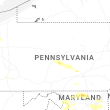
Pennsylvania
| Local Time | Report Details |
|---|---|
| 10:48 AM EDT | Wires down along centre street and franklin street. time estimated from rada in berks county PA, 72.4 miles S of Scranton, PA |
| 10:50 AM EDT | Wires down - wires down on an unoccupied car. time estimated from rada in berks county PA, 70.5 miles SSW of Scranton, PA |
| 10:54 AM EDT | Trees and wires down. time estimated from rada in lehigh county PA, 46.3 miles S of Scranton, PA |
| 10:55 AM EDT | *** 1 inj *** tree down on house in exeter township. report of at least 1 injury. time estimated from rada in berks county PA, 76.4 miles S of Scranton, PA |
| 11:38 AM EDT | Downed tree in wires on central av / cedar hollow rd northbound at central av. there is a traffic disruptio in chester county PA, 78.6 miles NE of Baltimore, MD |
| 11:45 AM EDT | Small and large tree branches down. time estimated from rada in chester county PA, 76.3 miles NE of Baltimore, MD |
| 12:05 PM EDT | Several large trees down in the andorra part of philadelphia. time estimated from rada in philadelphia county PA, 78.7 miles WSW of Brooklyn, NY |
| 12:06 PM EDT | Tree onto car. time estimated from rada in philadelphia county PA, 80.2 miles SW of Brooklyn, NY |
| 12:06 PM EDT | Telephone pole into a roof. time estimated from rada in philadelphia county PA, 76.4 miles SW of Brooklyn, NY |
| 12:06 PM EDT | Wires down. time estimated from rada in philadelphia county PA, 80.6 miles SW of Brooklyn, NY |
| 2:55 PM EDT | Tree down across roadway near laurel lan in huntingdon county PA, 16.2 miles WSW of State College, PA |
| 2:58 PM EDT | Trees down on wires northwest of warriors mar in huntingdon county PA, 15.8 miles WSW of State College, PA |
| 3:30 PM EDT | Half Dollar sized hail reported near Huntingdon, PA, 11.3 miles S of State College, PA |
| 3:48 PM EDT | Tree down on pennsylvania avenu in jefferson county PA, 54.2 miles WNW of State College, PA |
| 3:58 PM EDT | Trees down on wire in mifflin county PA, 20.8 miles SE of State College, PA |
| 4:52 PM EDT | Trees down across baltimore pike at white roa in adams county PA, 47.2 miles NW of Baltimore, MD |
| 5:10 PM EDT | Quarter sized hail reported near New Bloomfield, PA, 44.5 miles SE of State College, PA, quarter size hail near new bloomfield. |
| 5:30 PM EDT | Trees and wires down across jacobs mill roa in york county PA, 41 miles NNW of Baltimore, MD |
| 5:36 PM EDT | Trees and power poles down along grim hollow roa in york county PA, 40 miles N of Baltimore, MD |
| 5:42 PM EDT | Trees down on wire in york county PA, 48.5 miles N of Baltimore, MD |
| 5:44 PM EDT | Numerous reports of trees down in wires around arch roc in juniata county PA, 26.7 miles ESE of State College, PA |
| 5:52 PM EDT | Trees and wires down on steigerwalt hollow roa in york county PA, 63.6 miles NNW of Baltimore, MD |
| 6:04 PM EDT | Trees and wires down on a house on kittatinny sree in dauphin county PA, 63.9 miles SE of State College, PA |
| 6:21 PM EDT | Dispatch scanner reported a tree down on burns road near east lake road. time estimated via rada in crawford county PA, 63.4 miles E of Cleveland, OH |
| 6:30 PM EDT | Tree down on wires on state route 285 near south canal road. time estimated via rada in crawford county PA, 67.8 miles E of Cleveland, OH |
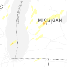
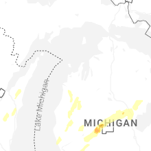
Michigan
| Local Time | Report Details |
|---|---|
| 11:16 AM EDT | Severe tree damage at the intersection of burgess drive and maple street. many trees/limbs dow in kalamazoo county MI, 47.5 miles SSE of Grand Rapids, MI |
| 4:00 PM EDT | Large branch about 10 inches in diameter broke from a tree in the yar in marquette county MI, 18.4 miles S of Marquette, MI |
| 8:01 PM EDT | Ping Pong Ball sized hail reported near Big Rapids, MI, 50.7 miles N of Grand Rapids, MI, report from mping: ping pong ball (1.50 in.). |
| 8:15 PM EDT | Half Dollar sized hail reported near Big Rapids, MI, 52.1 miles N of Grand Rapids, MI, north state st at west ave by the airport. |
| 8:15 PM EDT | Mesonet station xmapv minneapolis shoal in lmz221 county MI, 69.6 miles SSE of Marquette, MI |
| 8:21 PM EDT | Many trees down in a small region at the corner of red arrow highway (s lakeshore dr.) and brown school road in shoreham... mi. several trees down across the street and in berrien county MI, 59.2 miles ENE of Chicago, IL |
| 8:25 PM EDT | Ping Pong Ball sized hail reported near Shelby, MI, 51.2 miles NW of Grand Rapids, MI, m-20 at 120th st. |
| 8:45 PM EDT | Quarter sized hail reported near Remus, MI, 48.4 miles NNE of Grand Rapids, MI, report from mping: quarter (1.00 in.). |
| 8:50 PM EDT | Golf Ball sized hail reported near Remus, MI, 51.3 miles NNE of Grand Rapids, MI, spotter is at m-20 and m-66 in remus. |
| 10:11 PM EDT | Mdot rwis near coopersvill in ottawa county MI, 13.4 miles WNW of Grand Rapids, MI |
Ohio
| Local Time | Report Details |
|---|---|
| 11:40 AM EDT | Portage county 911 dispatch reports a tree down on waterloo road. time estimated via rada in portage county OH, 38.5 miles SSE of Cleveland, OH |
| 8:31 PM EDT | Trees and a utility pole blown dow in shelby county OH, 63 miles SE of Fort Wayne, IN |
| 8:35 PM EDT | A tree was downed and a gutter was blown of a house. time estimated from rada in auglaize county OH, 57.8 miles SE of Fort Wayne, IN |
| 8:37 PM EDT | Trees and power lines down. lightning stuck a utility pole and caused a tree to catch fir in shelby county OH, 65.1 miles WNW of Columbus, OH |
| 8:43 PM EDT | Power lines... poles... and trees down in multiple location in shelby county OH, 67.6 miles SE of Fort Wayne, IN |
| 8:43 PM EDT | Trees down on route 27 in shelby county OH, 63.8 miles SE of Fort Wayne, IN |
| 9:00 PM EDT | Quarter sized hail reported near Middletown, OH, 27.9 miles NNE of Cincinnati, OH |
| 9:05 PM EDT | Half Dollar sized hail reported near Hamilton, OH, 17.5 miles N of Cincinnati, OH |
| 9:09 PM EDT | Quarter sized hail reported near Monroe, OH, 24.6 miles NNE of Cincinnati, OH |
| 9:11 PM EDT | Several large trees were downed on a propert in logan county OH, 49.2 miles NW of Columbus, OH |
| 9:13 PM EDT | A large tree was downe in hardin county OH, 65.2 miles NW of Columbus, OH |
| 9:20 PM EDT | Tree limbs downe in madison county OH, 25.9 miles W of Columbus, OH |
| 9:34 PM EDT | Large tree dow in clinton county OH, 36.8 miles NE of Cincinnati, OH |
| 9:40 PM EDT | Numerous tree branches were downe in clinton county OH, 38.9 miles NE of Cincinnati, OH |
| 9:40 PM EDT | A tree was downed blocking the roadwa in clinton county OH, 40.3 miles ENE of Cincinnati, OH |
| 9:42 PM EDT | Trees and large branches downed. roofing ductwork blown of in clinton county OH, 43.2 miles ENE of Cincinnati, OH |
| 9:45 PM EDT | Tennis Ball sized hail reported near Wilmington, OH, 39.7 miles ENE of Cincinnati, OH |
| 9:46 PM EDT | Tennis Ball sized hail reported near Wilmington, OH, 41.6 miles ENE of Cincinnati, OH |
| 9:48 PM EDT | Quarter sized hail reported near Wilmington, OH, 41.5 miles ENE of Cincinnati, OH |
| 9:52 PM EDT | Asos station kmnn mario in marion county OH, 45.5 miles N of Columbus, OH |
| 9:52 PM EDT | Marion county 911 dispatch has numerous reports of trees and wires down across the city of mario in marion county OH, 43.8 miles N of Columbus, OH |
| 9:56 PM EDT | Trees downed across the count in delaware county OH, 21.3 miles N of Columbus, OH |
| 9:58 PM EDT | Half Dollar sized hail reported near Sabina, OH, 47.9 miles SW of Columbus, OH |
| 10:05 PM EDT | Half Dollar sized hail reported near Sabina, OH, 48.2 miles SW of Columbus, OH |
| 10:06 PM EDT | Tennis Ball sized hail reported near Leesburg, OH, 51.1 miles SW of Columbus, OH |
| 10:13 PM EDT | Hen Egg sized hail reported near Washington Court House, OH, 45.8 miles SW of Columbus, OH |
| 10:18 PM EDT | County dispatch scanner reported multiple tree limbs and powerlines down on lenox avenue. time estimated via rada in richland county OH, 61.9 miles NNE of Columbus, OH |
| 10:20 PM EDT | Ping Pong Ball sized hail reported near Greenfield, OH, 47 miles SSW of Columbus, OH |
| 10:24 PM EDT | Asos station kmfd mansfiel in richland county OH, 64 miles SW of Cleveland, OH |
| 10:30 PM EDT | Huron county ema reports tree limbs... power poles... and power lines down in the southeast portion of the county including around greenwich. time estimated via rada in huron county OH, 54.2 miles SW of Cleveland, OH |
| 10:47 PM EDT | Trees down on the south side of wooster including on the elm street extension and clinton and vanove in wayne county OH, 51 miles SSW of Cleveland, OH |
| 10:48 PM EDT | Wayne county 911 dispatch reports a large tree down with power lines on college avenue. time estimated via rada in wayne county OH, 49.7 miles SSW of Cleveland, OH |
| 10:48 PM EDT | Tree down on the 800 block of bever street. time estimated via rada in wayne county OH, 49.7 miles SSW of Cleveland, OH |
| 11:00 PM EDT | Tree down. time estimated by rada in perry county OH, 55.1 miles ESE of Columbus, OH |
| 11:04 PM EDT | Tree down. time estimated from rada in vinton county OH, 52.8 miles SSE of Columbus, OH |
| 11:05 PM EDT | 911 dispatch scanner reported a tree down on south academy street. time estimated via rada in medina county OH, 36.7 miles SSW of Cleveland, OH |
| 11:05 PM EDT | 911 dispatch scanner reported a tree down on wires on mill street. time estimated via rada in medina county OH, 36.7 miles SSW of Cleveland, OH |
| 11:11 PM EDT | Local dispatch scanner reported a tree down on manchester road. time estimated via rada in summit county OH, 38.8 miles S of Cleveland, OH |
| 11:15 PM EDT | Medium to large tree branches down near intersection of rose circle drive and akron view driv in summit county OH, 34.7 miles S of Cleveland, OH |
| 11:15 PM EDT | Local dispatch scanner reported trees down on glennbrook roa in summit county OH, 32.1 miles S of Cleveland, OH |
| 11:15 PM EDT | Local dispatch scanner reported state route 619 west of state street impassable due to trees down. time estimated via rada in summit county OH, 36.9 miles SSE of Cleveland, OH |
| 11:17 PM EDT | Local dispatch scanner reported powerlines down on 7th street northwest. time estimated via rada in summit county OH, 33.7 miles S of Cleveland, OH |
| 11:18 PM EDT | Tree down blocking entire roadway at w. canal st. and meyers st. in nelsonville. time estimated from rada in vinton county OH, 52.8 miles SSE of Columbus, OH |
| 11:18 PM EDT | Tree on powerlines and on fire with sparking. time estimated from rada in athens county OH, 53.8 miles SE of Columbus, OH |
| 11:20 PM EDT | Report of a tree down along cherry run road nw. time estimated based on rada in tuscarawas county OH, 64 miles S of Cleveland, OH |
| 11:23 PM EDT | Tree down on power lines on burr oak blvd in nelsonvill in athens county OH, 55 miles SE of Columbus, OH |
| 11:23 PM EDT | Tree down on power lines on forth st e in south poin in lawrence county OH, 51.9 miles W of Charleston, WV |
| 11:26 PM EDT | Tree down on power lines in st rt 78 in glouste in athens county OH, 57.8 miles ESE of Columbus, OH |
| 11:29 PM EDT | Asos station kakr akron fulton airport reported a 57 kt thunderstorm wind gus in summit county OH, 34.2 miles SSE of Cleveland, OH |
| 11:30 PM EDT | Tree down. time estimated by rada in athens county OH, 53.8 miles SE of Columbus, OH |
| 11:31 PM EDT | Tree down on buchtel rd in nelsonvill in athens county OH, 53.8 miles SE of Columbus, OH |
| 11:37 PM EDT | Portage county 911 dispatch reports a tree down on the 1400 block trares road. time estimated via rada in portage county OH, 36.9 miles SSE of Cleveland, OH |
| 11:37 PM EDT | Portage county 911 dispatch reports a tree down at us route 224 and congress lake roa in portage county OH, 37.7 miles SSE of Cleveland, OH |
| 11:40 PM EDT | Portage county 911 dispatch reports a tree down on summit street in kent. time estimated via rada in portage county OH, 30.2 miles SE of Cleveland, OH |
| 11:42 PM EDT | Portage county 911 dispatch reports a tree down on old forge road. time estimated via rada in portage county OH, 37.1 miles SE of Cleveland, OH |
| 11:45 PM EDT | Portage county 911 dispatch reports a tree down interstate 76 near mile marker 40.5. time estimated via rada in portage county OH, 37 miles SE of Cleveland, OH |
| 11:45 PM EDT | Portage county 911 dispatch reports a large tree down on gower road at new milford with power line wrapped into tree. time estimated via rada in portage county OH, 37.1 miles SE of Cleveland, OH |
| 11:50 PM EDT | Tree down. time estimated by rada in athens county OH, 58.1 miles ESE of Columbus, OH |
| 11:53 PM EDT | Tree down. time estimated by rada in athens county OH, 57.6 miles SE of Columbus, OH |
| 11:57 PM EDT | Tree down on myers st in nelsonville. time estimated by rada in athens county OH, 55.2 miles SE of Columbus, OH |
| 12:04 AM EDT | Tree down at w. franklin st. and madison st. time reported corroborated with rada in athens county OH, 53.4 miles SE of Columbus, OH |
| 12:05 AM EDT | Tree limbs down in harrietsville. time estimated via rada in noble county OH, 89.7 miles N of Charleston, WV |
| 12:11 AM EDT | Report of multiple trees down along oh 800 north of woodsville. time estimated based on rada in monroe county OH, 74.8 miles SW of Pittsburgh, PA |
| 12:47 AM EDT | Trees down across the roa in jefferson county OH, 33.5 miles WSW of Pittsburgh, PA |
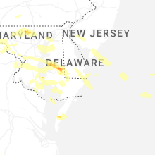
New Jersey
| Local Time | Report Details |
|---|---|
| 12:36 PM EDT | Report of a heavily damaged shed around the bridgeton area. possible tornad in cumberland county NJ, 74.3 miles E of Baltimore, MD |
| 12:38 PM EDT | Trees and powerlines down. time estimated from rada in gloucester county NJ, 86.9 miles ENE of Baltimore, MD |
| 12:41 PM EDT | Trees and wires down throughout the area. time estimated from rada in gloucester county NJ, 88.4 miles SW of Brooklyn, NY |
| 12:50 PM EDT | Tress down along cains mill road. time estimated from rada in atlantic county NJ, 86.5 miles N of Ocean City, MD |
| 12:52 PM EDT | Trees and wires down along route 54 near hammonton. time estimated from rada in atlantic county NJ, 87.2 miles SSW of Brooklyn, NY |
| 12:56 PM EDT | Trees and wires down on edgewood road. tornado possibl in atlantic county NJ, 87.9 miles N of Ocean City, MD |
| 12:56 PM EDT | Numerous trees and wires down across collings lakes... at least one into a house with major damage. possible tornado. time estimated from rada in atlantic county NJ, 87.3 miles N of Ocean City, MD |
| 12:58 PM EDT | Numerous trees down cains mill rd section of collings lakes. time estimated from rada in atlantic county NJ, 87.3 miles N of Ocean City, MD |
| 1:45 PM EDT | Wires down on gravel hole road and holly glen lane. wires sparking. time estimated from rada in cape may county NJ, 59.5 miles NNE of Ocean City, MD |
| 2:00 PM EDT | Golf Ball sized hail reported near Avalon, NJ, 56.3 miles NNE of Ocean City, MD, hail up to the size of golf ball. time estimated from radar. |
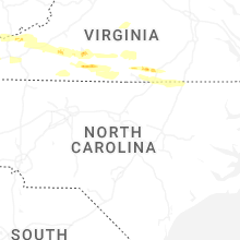
Virginia
| Local Time | Report Details |
|---|---|
| 12:56 PM EDT | Tree down on kid mill rd in vansant. time estimated via rada in buchanan county VA, 44.3 miles N of Bristol, TN |
| 1:36 PM EDT | Buchanan county 911 center reports a tree down on lovers gap rd just past southern gap road. time estimated by rada in buchanan county VA, 42.8 miles N of Bristol, TN |
| 2:03 PM EDT | A couple trees downed by thunderstorm winds on mill creek road near boxwood lane. time estimated from rada in tazewell county VA, 40.2 miles NNE of Bristol, TN |
| 2:25 PM EDT | Thunderstorm winds blew down one tree on niday driv in bland county VA, 60.1 miles W of Roanoke, VA |
| 2:29 PM EDT | Trees dow in wise county VA, 36.6 miles NW of Bristol, TN |
| 2:41 PM EDT | Social media post reported several trees down across route 42 in bland count in bland county VA, 65.7 miles ENE of Bristol, TN |
| 2:43 PM EDT | Thunderstorm winds blew down one tree along the 3800 block of east blue grass trai in bland county VA, 62.1 miles W of Roanoke, VA |
| 2:44 PM EDT | Thunderstorm winds blew down one tree near the intersection of wilderness road and kimberling roa in bland county VA, 57 miles W of Roanoke, VA |
| 2:45 PM EDT | Trees dow in wise county VA, 28.3 miles NNW of Bristol, TN |
| 2:49 PM EDT | Thunderstorm winds blew down one tree along the 800 block of wilderness roa in bland county VA, 53.9 miles W of Roanoke, VA |
| 2:54 PM EDT | Buchanan county 911 center reports tree down around the 80 block of slate creek rd. time estimated via rada in buchanan county VA, 49.7 miles N of Bristol, TN |
| 3:09 PM EDT | Several trees dow in russell county VA, 23.4 miles N of Bristol, TN |
| 3:11 PM EDT | 55 knot gust measured on rsois uni in montgomery county VA, 26.2 miles W of Roanoke, VA |
| 3:22 PM EDT | Quarter sized hail reported near Christiansburg, VA, 31.8 miles WSW of Roanoke, VA |
| 3:49 PM EDT | Thunderstorm winds blew down multiple trees along the 700 block of west chilhowie stree in smyth county VA, 42 miles ENE of Bristol, TN |
| 3:55 PM EDT | Large tree knocked down along jared square ne in leesbur in loudoun county VA, 51.8 miles WSW of Baltimore, MD |
| 3:57 PM EDT | Quarter sized hail reported near Rocky Mount, VA, 18.9 miles S of Roanoke, VA |
| 3:59 PM EDT | Tree down near the intersection of owl ln. and carpers p in frederick county VA, 82.4 miles ENE of Elkins, WV |
| 4:06 PM EDT | Tree down near the intersection of cedar hill rd. and welltown r in frederick county VA, 81.5 miles W of Baltimore, MD |
| 4:14 PM EDT | Quarter sized hail reported near Gretna, VA, 38.5 miles SE of Roanoke, VA, hail up to the size of quarters fell. the time was estimated from radar. |
| 4:22 PM EDT | Tree down onto roadway near the intersection of summerville rd and pyletown roa in clarke county VA, 78.3 miles W of Baltimore, MD |
| 4:22 PM EDT | Tree down onto roadway near the intersection of longmarsh rd and crums church roa in clarke county VA, 75.4 miles W of Baltimore, MD |
| 4:25 PM EDT | Quarter sized hail reported near Dillwyn, VA, 44.8 miles W of Richmond, VA |
| 4:30 PM EDT | Three trees down along telegraph road. time estimated from rada in pittsylvania county VA, 43.2 miles ESE of Roanoke, VA |
| 4:45 PM EDT | Quarter sized hail reported near Martinsville, VA, 41 miles S of Roanoke, VA |
| 4:46 PM EDT | A couple trees down along tight squeeze road. time estimated from rada in pittsylvania county VA, 43.9 miles SE of Roanoke, VA |
| 4:53 PM EDT | Several trees snapped and uprooted on hughesville rd. just south of lincol in loudoun county VA, 60 miles WSW of Baltimore, MD |
| 5:03 PM EDT | A few trees down in the vicinity of old richmond road... north of danville. time estimated from rada in pittsylvania county VA, 53.3 miles SE of Roanoke, VA |
| 5:03 PM EDT | Tree down partially blocking mitchell road near eggleston falls roa in henry county VA, 46.9 miles S of Roanoke, VA |
| 5:05 PM EDT | A large tree and power lines were downed onto a house. time estimated from rada in pittsylvania county VA, 53.1 miles SE of Roanoke, VA |
| 5:05 PM EDT | Tree down on ringgold church road partially blocking roadway. time estimated from rada in pittsylvania county VA, 55.3 miles SE of Roanoke, VA |
| 5:08 PM EDT | Tree down on hummingbird road near oak level roa in halifax county VA, 59.2 miles SE of Roanoke, VA |
| 5:08 PM EDT | Several large branches were broken off... and the tin roof of a barn was blown off. in addition... a few trees were downed along nearby sunny side lane. time estimated in charlotte county VA, 66.9 miles SW of Richmond, VA |
| 5:10 PM EDT | Tree down along kerns mill road... near its intersection with kerns church roa in pittsylvania county VA, 60.3 miles SE of Roanoke, VA |
| 5:15 PM EDT | Numerous reports of trees down along hampton r in fairfax county VA, 53.8 miles SW of Baltimore, MD |
| 5:18 PM EDT | Tree down blocking the road on fort mitchell driv in lunenburg county VA, 61 miles SW of Richmond, VA |
| 5:22 PM EDT | A few trees were downed along philpott road. time estimated from rada in halifax county VA, 61.7 miles NNW of Raleigh, NC |
| 5:23 PM EDT | Several trees down in the vicinity of courthouse rd. time estimate in lunenburg county VA, 57.9 miles SW of Richmond, VA |
| 5:23 PM EDT | Trees down in the vicinity of lunenburg county rd. time estimate in lunenburg county VA, 53.9 miles SW of Richmond, VA |
| 5:25 PM EDT | Public report of multiple trees snapped near the intersection of franconia road and beulah stree in fairfax county VA, 45.7 miles SW of Baltimore, MD |
| 5:25 PM EDT | Tree down blocking the road on rehoboth r in lunenburg county VA, 56.6 miles SW of Richmond, VA |
| 5:27 PM EDT | Large tree down near intersection of cluster springs road and old cluster springs roa in halifax county VA, 59.7 miles NNW of Raleigh, NC |
| 5:29 PM EDT | Several trees down with multiple power outages reports in the city of alexandri in city of alexandria county VA, 41.5 miles SW of Baltimore, MD |
| 5:30 PM EDT | Half Dollar sized hail reported near Falls Church, VA, 41.3 miles SW of Baltimore, MD |
| 5:33 PM EDT | Tree down in the vicinity of oral oaks rd. time estimate in lunenburg county VA, 50.4 miles SW of Richmond, VA |
| 5:33 PM EDT | Numerous large trees down near the intersection of george washington memorial pkwy and morningside ln. one tree fell onto a vehicl in fairfax county VA, 44.2 miles SSW of Baltimore, MD |
| 5:34 PM EDT | *** 1 fatal *** tree fell on vehicle killing occupant. time approximated by radar wind observatio in fairfax county VA, 44.2 miles SSW of Baltimore, MD |
| 5:34 PM EDT | *** 1 fatal *** tree fell on vehicle killing female occupant. time approximated by radar wind observatio in fairfax county VA, 47.1 miles SW of Baltimore, MD |
| 5:36 PM EDT | Several trees down in the vicinity of poorhouse r in lunenburg county VA, 44.4 miles SW of Richmond, VA |
| 5:38 PM EDT | Storm damage reported in arlington county VA, 37.9 miles SW of Baltimore, MD |
| 5:45 PM EDT | Many trees down across the county... particularly for southern portions of the county near boydton and clarksville. time estimate in mecklenburg county VA, 61.9 miles NNE of Raleigh, NC |
| 5:50 PM EDT | Multiple trees down blocking the south bound lanes on i-85. time estimate in brunswick county VA, 45.7 miles SSW of Richmond, VA |
| 6:02 PM EDT | Tree knocked down near the intersection of mckenney hwy and cherry hill rd. time estimated from rada in dinwiddie county VA, 38.2 miles S of Richmond, VA |
| 6:02 PM EDT | Tree knocked down on us-1 in the vicinity of old stage rd. time estimated from rada in brunswick county VA, 39.2 miles S of Richmond, VA |
| 6:15 PM EDT | Tree down on little mill rd near stony creek. time estimate in sussex county VA, 39.8 miles SSE of Richmond, VA |
| 6:20 PM EDT | Tree down on walkers mill rd. time estimate in sussex county VA, 44.7 miles S of Richmond, VA |
| 6:30 PM EDT | Tree down on sylvan rd in waverl in sussex county VA, 44.5 miles SE of Richmond, VA |
| 6:30 PM EDT | Multiple trees down along va 35 in sussex count in sussex county VA, 42.9 miles SSE of Richmond, VA |
| 6:30 PM EDT | Picture from the wavy-tv facebook page of a large tree downed into a home in exmore. time estimate in northampton county VA, 55.1 miles NNE of Virginia Beach, VA |
| 6:35 PM EDT | Trees and powerlines dow in northampton county VA, 53.9 miles NNE of Virginia Beach, VA |
| 6:36 PM EDT | Several trees down in quinby. time estimate in accomack county VA, 58.4 miles NNE of Virginia Beach, VA |
| 6:42 PM EDT | Multiple trees down in ivor. time estimate in southampton county VA, 47.3 miles WNW of Virginia Beach, VA |
| 6:53 PM EDT | Reports of wires down. time estimate in city of suffolk county VA, 40.3 miles W of Virginia Beach, VA |
| 6:59 PM EDT | Report of wires down. time estimate in city of suffolk county VA, 31.8 miles W of Virginia Beach, VA |
| 6:59 PM EDT | Report of wires down. time estimate in city of suffolk county VA, 39.9 miles WSW of Virginia Beach, VA |
| 7:00 PM EDT | Report of wires down. time estimate in city of suffolk county VA, 29.1 miles W of Virginia Beach, VA |
| 7:00 PM EDT | Tree down in suffolk near the intersection of us-460 and and us-58. time estimate in city of suffolk county VA, 30 miles W of Virginia Beach, VA |
| 7:02 PM EDT | Report of wires down. time estimate in city of suffolk county VA, 29.5 miles W of Virginia Beach, VA |
| 7:02 PM EDT | Report of wires down. time estimate in city of suffolk county VA, 30.3 miles W of Virginia Beach, VA |
| 7:04 PM EDT | Report of wires down. time estimate in city of suffolk county VA, 25.3 miles WNW of Virginia Beach, VA |
| 7:19 PM EDT | Tree fell on an apartment building and partially collapsed the building. time estimate in city of portsmouth county VA, 17.8 miles WNW of Virginia Beach, VA |
| 7:20 PM EDT | Trees down in the vicinity of tyre neck rd and norfolk rd in portsmouth... causing power outages. time estimate in city of portsmouth county VA, 19.7 miles WNW of Virginia Beach, VA |
| 7:20 PM EDT | Tree down near churchland bridge in portsmouth. time estimate in city of portsmouth county VA, 18.2 miles WNW of Virginia Beach, VA |
| 7:20 PM EDT | Downed power pole. time estimate in city of chesapeake county VA, 15.1 miles W of Virginia Beach, VA |
| 11:14 PM EDT | Report of wires down. time estimate in city of suffolk county VA, 29.1 miles W of Virginia Beach, VA |
West Virginia
| Local Time | Report Details |
|---|---|
| 1:01 PM EDT | Mcdowell county 911 center reports a tree down 200 block of ostenaco rd. power lines involved with sparks emitting from the lines. time estimated via rada in mcdowell county WV, 62.1 miles NNE of Bristol, TN |
| 1:46 PM EDT | Tree down on marshall highway near sunamco market in jolo. time estimated via rada in mcdowell county WV, 55.8 miles NNE of Bristol, TN |
| 1:55 PM EDT | Tree down on crawley creek road between canoe bridge rd and mills branch road near chapmanville... wv. tree is blocking half a lan in logan county WV, 34.7 miles SW of Charleston, WV |
| 1:56 PM EDT | Tree down on big jenny branch road near davy... wv. time estimated via rada in mcdowell county WV, 60.7 miles S of Charleston, WV |
| 2:00 PM EDT | Tree damage resulting in 52 customers without power. time is estimated by rada in mcdowell county WV, 63.7 miles S of Charleston, WV |
| 2:02 PM EDT | Tree reported down blocking one lane of spencer bottom road. time is estimated by rada in mcdowell county WV, 67.3 miles NE of Bristol, TN |
| 2:12 PM EDT | Thunderstorm winds blew down one tree on cherry street near the intersection with woodside driv in mercer county WV, 71.1 miles W of Roanoke, VA |
| 2:15 PM EDT | Tree down blocking 1 lane on route 10 at stone branch road. time estimated via rada in logan county WV, 32.7 miles SW of Charleston, WV |
| 2:16 PM EDT | Raleigh county 911 center reports a tree down in the 100 block of trump road in bolt... wv. time estimated via rada in raleigh county WV, 42.1 miles SSE of Charleston, WV |
| 2:18 PM EDT | Raleigh county 911 reports a tree down in the 3500 block of coal river rd in dameron... wv. time estimated via rada in raleigh county WV, 40.2 miles SSE of Charleston, WV |
| 2:18 PM EDT | Thunderstorm winds blew down one tree on the 400 block of ingleside road close to a water plan in mercer county WV, 67.2 miles W of Roanoke, VA |
| 2:20 PM EDT | Asos station kckb clarksburg airpor in harrison county WV, 32.9 miles NW of Elkins, WV |
| 2:33 PM EDT | Tree down on church stree in preston county WV, 32.2 miles N of Elkins, WV |
| 2:35 PM EDT | Three trees reported down... with beverly pike roadway blocke in taylor county WV, 36.3 miles NNW of Elkins, WV |
| 2:36 PM EDT | Tree down with cable lines on galloway junction rd near philippi. time estimated via rada in barbour county WV, 26.4 miles NW of Elkins, WV |
| 2:37 PM EDT | Tree fell on a house on bear mountain rd... in flemington... wv near the elementary school. time estimated via rada in barbour county WV, 26.5 miles NW of Elkins, WV |
| 2:38 PM EDT | Two trees down on power lines. trees are blocking burnt cabin roa in marion county WV, 35.6 miles NNW of Elkins, WV |
| 2:38 PM EDT | Tree reported down with live lines. time is estimated by rada in taylor county WV, 28.8 miles NNW of Elkins, WV |
| 2:40 PM EDT | Corrects previous tstm wnd dmg report from 2 sw reedsville. tree down on stony run road. tree fell on ambulanc in preston county WV, 39 miles N of Elkins, WV |
| 2:42 PM EDT | Tree reported down near the intersection of country club road and turner road. time is estimated by rada in taylor county WV, 33 miles NNW of Elkins, WV |
| 2:44 PM EDT | Tree down on george washington highwa in preston county WV, 28.6 miles NNE of Elkins, WV |
| 2:52 PM EDT | Tree down in bruceton mill in preston county WV, 51.9 miles NNE of Elkins, WV |
| 2:54 PM EDT | Logan 911 center reports a tree down blocking the southbound lane on route 44 near the atv crossing south of logan. time estimated via rada in logan county WV, 40.9 miles SSW of Charleston, WV |
| 2:57 PM EDT | Tree down on bucklick roa in preston county WV, 36 miles NNE of Elkins, WV |
| 2:58 PM EDT | Tree reported down on marshall highway blocking the roadway. time is estimated by rada in mcdowell county WV, 55.8 miles NNE of Bristol, TN |
| 3:01 PM EDT | Tree down on rift-berwind rd near the railroad trussel by the va line. time estimated via rada in mcdowell county WV, 53.4 miles NE of Bristol, TN |
| 3:05 PM EDT | Multiple trees reported dow in mcdowell county WV, 63.1 miles NNE of Bristol, TN |
| 3:20 PM EDT | Storm damage reported in mineral county WV, 75.4 miles NE of Elkins, WV |
| 3:37 PM EDT | Multiple trees down near wiley for in mineral county WV, 74.6 miles NE of Elkins, WV |
| 3:46 PM EDT | Trees down between yellow spring and capon bridg in hampshire county WV, 76 miles ENE of Elkins, WV |
| 3:55 PM EDT | Public reports four trees downed in vicinity of capon bridg in hampshire county WV, 79.8 miles ENE of Elkins, WV |
| 4:04 PM EDT | Tree down on sir johns run roa in morgan county WV, 82 miles SSW of State College, PA |
| 4:08 PM EDT | Tree down onto roadway near the intersection of apple harvest drive and tub run hollow roa in berkeley county WV, 84.9 miles W of Baltimore, MD |
| 4:17 PM EDT | Numerous trees down in martinsbur in berkeley county WV, 73.8 miles W of Baltimore, MD |
| 4:24 PM EDT | Public reports large tree branches downed near va center in kearnysvill in berkeley county WV, 69.7 miles W of Baltimore, MD |
| 4:24 PM EDT | Storm damage reported in berkeley county WV, 73.8 miles W of Baltimore, MD |
| 10:35 PM EDT | Tree down blocking one lane near the intersection of route 52 and novamont driv in wayne county WV, 51.7 miles W of Charleston, WV |
| 11:15 PM EDT | Tree down on stuart cir and us 60 in hurricane. time estimated by rada in putnam county WV, 22.3 miles WNW of Charleston, WV |
| 11:20 PM EDT | Tree down on one lane across teays valley rd. time estimated by rada in putnam county WV, 21.8 miles WNW of Charleston, WV |
| 11:20 PM EDT | Tree down blocking one lane toward teays valley. time estimated by rada in putnam county WV, 18.8 miles NW of Charleston, WV |
| 11:34 PM EDT | Tree blocking south bound lane on billy branch rd and route 152 in genoa. time estimated by rada in wayne county WV, 47.4 miles WSW of Charleston, WV |
| 11:42 PM EDT | Tree blocking entire road in elk creek. traffic cannot get by. time estimated by rada in mingo county WV, 49.7 miles SW of Charleston, WV |
| 11:42 PM EDT | Tree down on power lines blocking both lanes on the highway. bowtie ln... williamso in mingo county WV, 56 miles SW of Charleston, WV |
| 11:45 PM EDT | Several trees down in crooked creek. time estimated by rada in logan county WV, 37.1 miles SSW of Charleston, WV |
| 11:53 PM EDT | Tree down on lower mill creek and rt 52 in fort gay. time estimated by rada in wayne county WV, 51.5 miles WSW of Charleston, WV |
| 11:55 PM EDT | Tree down in madison. time estimated by rada in boone county WV, 22.6 miles SSW of Charleston, WV |
| 11:58 PM EDT | Tree down in ivydale. time estimated by rada in clay county WV, 35 miles ENE of Charleston, WV |
| 12:03 AM EDT | Tree down. time estimated by rada in boone county WV, 22.7 miles SSW of Charleston, WV |
| 12:15 AM EDT | Tree down. time estimated by rada in boone county WV, 24.6 miles S of Charleston, WV |
| 12:22 AM EDT | Tree down. time estimated by rada in boone county WV, 29.5 miles SSW of Charleston, WV |
| 1:05 AM EDT | Tree down on army camp rd in prince. time estimated by rada in fayette county WV, 45.1 miles SE of Charleston, WV |
Delaware
| Local Time | Report Details |
|---|---|
| 2:31 PM EDT | Golf Ball sized hail reported near Millsboro, DE, 20.6 miles NW of Ocean City, MD, report from mping: golf ball (1.75 in.). |
| 7:05 PM EDT | Extensive tree damage including downed trees on rd 493. time estimated from rada in sussex county DE, 32.3 miles WNW of Ocean City, MD |
| 7:10 PM EDT | Numerous trees and wires down across the west side of laurel. time estimated from rada in sussex county DE, 30.6 miles WNW of Ocean City, MD |
Maryland
| Local Time | Report Details |
|---|---|
| 3:05 PM EDT | Tree down on wire in garrett county MD, 40.6 miles NE of Elkins, WV |
| 3:37 PM EDT | Tree down near the 800 block of shades lan in allegany county MD, 77.6 miles NE of Elkins, WV |
| 3:51 PM EDT | Numerous trees down around flintston in allegany county MD, 84.3 miles SSW of State College, PA |
| 3:59 PM EDT | Multiple trees down around little orlean in allegany county MD, 85 miles SSW of State College, PA |
| 4:36 PM EDT | Trees down on wire in franklin county PA, 67.3 miles WNW of Baltimore, MD |
| 4:44 PM EDT | A couple of trees reported down in kensingto in montgomery county MD, 30.6 miles SW of Baltimore, MD |
| 4:46 PM EDT | Power lines reported down in silver spring... one of which was a snapped power pol in montgomery county MD, 31 miles SW of Baltimore, MD |
| 4:57 PM EDT | Several trees reported down along the us-15 corridor from utica to frederic in frederick county MD, 44.5 miles WNW of Baltimore, MD |
| 4:57 PM EDT | Several trees reported down along the us-15 corridor from utica to frederic in frederick county MD, 44.9 miles WNW of Baltimore, MD |
| 4:58 PM EDT | Several reports of trees down along the us-15 corridor from emmittsburg south through thurmon in frederick county MD, 44.5 miles WNW of Baltimore, MD |
| 4:58 PM EDT | Trees reported down on ridge ave. in mt. air in carroll county MD, 30 miles W of Baltimore, MD |
| 5:11 PM EDT | Ping Pong Ball sized hail reported near Westminster, MD, 29.4 miles NW of Baltimore, MD |
| 5:12 PM EDT | Quarter sized hail reported near Westminster, MD, 28.1 miles NW of Baltimore, MD |
| 5:16 PM EDT | Carroll county em reports several trees downed from south of westminster to winfiel in carroll county MD, 26.5 miles WNW of Baltimore, MD |
| 5:16 PM EDT | Tree branches onto wires along the 14000 block of darnestown roa in montgomery county MD, 38.8 miles WSW of Baltimore, MD |
| 5:19 PM EDT | Multiple reports of power lines down in new windsor... m in carroll county MD, 32.2 miles NW of Baltimore, MD |
| 5:20 PM EDT | Wires and tree branches down near the 14000 block of darnestown road in montgomery county MD, 38.8 miles WSW of Baltimore, MD |
| 5:21 PM EDT | Numerous reports of downed trees in derwood in montgomery county MD, 33.1 miles WSW of Baltimore, MD |
| 5:21 PM EDT | Around a dozen trees downed in the deerwood are in montgomery county MD, 31.8 miles WSW of Baltimore, MD |
| 5:22 PM EDT | Montgomery county em reports several trees downed in the flower hills area. a tree fell onto a house near intersection of cochrane ct and cochrane way in montgomery county MD, 31.7 miles WSW of Baltimore, MD |
| 5:27 PM EDT | Montgomery county em reports tree onto a house at 19000 block of new hampshire av in montgomery county MD, 23.5 miles WSW of Baltimore, MD |
| 5:28 PM EDT | Tennis Ball sized hail reported near Upperco, MD, 22.3 miles NNW of Baltimore, MD |
| 5:29 PM EDT | 1 foot diameter tree dow in montgomery county MD, 34.4 miles SW of Baltimore, MD |
| 5:30 PM EDT | Tree branches downed onto power lines along 4400 block of edgebrook roa in montgomery county MD, 30.3 miles WSW of Baltimore, MD |
| 5:31 PM EDT | Several trees downed on harpers farm roa in howard county MD, 15.6 miles WSW of Baltimore, MD |
| 5:34 PM EDT | Quarter sized hail reported near Glyndon, MD, 17.4 miles NW of Baltimore, MD |
| 5:34 PM EDT | Carroll county em reports numerous trees downed in the hampstead are in carroll county MD, 26.4 miles NNW of Baltimore, MD |
| 5:39 PM EDT | Reports of multiple trees down on nunnery lan in baltimore county MD, 6 miles W of Baltimore, MD |
| 5:40 PM EDT | Large tree downed on oak drive in catonsvill in baltimore county MD, 7.1 miles WSW of Baltimore, MD |
| 5:43 PM EDT | Two trees down at spotter locatio in charles county MD, 68.3 miles NE of Richmond, VA |
| 5:44 PM EDT | Mdot sensor gust to 62 mp in anne arundel county MD, 21.7 miles S of Baltimore, MD |
| 5:45 PM EDT | Storm damage reported in prince georges county MD, 40 miles SSW of Baltimore, MD |
| 5:47 PM EDT | Storm damage reported in prince georges county MD, 36.6 miles SSW of Baltimore, MD |
| 5:48 PM EDT | Siding partially removed off an apartment building near the 140 block of nunnery lan in baltimore county MD, 6 miles W of Baltimore, MD |
| 5:52 PM EDT | Reports of trees down in the jarrettsville in harford county MD, 22.6 miles NNE of Baltimore, MD |
| 5:52 PM EDT | Metal roof on gym partially remove in baltimore city county MD, 2.2 miles ESE of Baltimore, MD |
| 5:53 PM EDT | Damage to building along boston street and s clinton st in baltimore city county MD, 2.2 miles ESE of Baltimore, MD |
| 5:57 PM EDT | Reports of trees down in the fallston are in harford county MD, 18.5 miles NNE of Baltimore, MD |
| 6:00 PM EDT | Reports of trees down in the bel air are in harford county MD, 21.6 miles NE of Baltimore, MD |
| 6:00 PM EDT | Large tree and several power lines downed along ferry landing road in dunkir in calvert county MD, 40.2 miles S of Baltimore, MD |
| 6:00 PM EDT | Significant tree... power line... and damage to buildings along merritt blvd and meadow lan in baltimore county MD, 5.7 miles ESE of Baltimore, MD |
| 6:01 PM EDT | Tree downed onto power lines at intersection of soaper ave and magothy beach rd in pasaden in anne arundel county MD, 13.4 miles SSE of Baltimore, MD |
| 6:01 PM EDT | Reports of trees down in the joppa are in harford county MD, 16.5 miles NE of Baltimore, MD |
| 6:05 PM EDT | Several trees downed in piney point are in st. marys county MD, 76.3 miles NE of Richmond, VA |
| 6:06 PM EDT | Roofs blown off a couple row houses... trees downed... and other minor structural damage on fairway in old dundalk next to yorkway along with yorkway and sellers point in baltimore county MD, 6 miles ESE of Baltimore, MD |
| 6:10 PM EDT | Quarter sized hail reported near Easton, MD, 46.2 miles SE of Baltimore, MD, report sent on social media of 1 inch hail. |
| 6:10 PM EDT | Trees snapped near the 2100 block of broening highwa in baltimore city county MD, 4 miles ESE of Baltimore, MD |
| 6:10 PM EDT | Several trees and power lines downed near 2900th block of main street in edgewate in anne arundel county MD, 23.6 miles S of Baltimore, MD |
| 6:14 PM EDT | Storm damage reported in st. marys county MD, 70.5 miles S of Baltimore, MD |
| 6:14 PM EDT | Storm damage reported in anz532 county MD, 28.9 miles SSE of Baltimore, MD |
| 6:22 PM EDT | Ndbc sensor (slim2) gust to 66 mp in anz542 county MD, 67.5 miles S of Baltimore, MD |
| 6:33 PM EDT | Storm damage reported in anz541 county MD, 44.7 miles SSE of Baltimore, MD |
| 6:40 PM EDT | Picture of a snapped tree sent via social media. time estimated from rada in talbot county MD, 46 miles SSE of Baltimore, MD |
| 6:40 PM EDT | Ping Pong Ball sized hail reported near Preston, MD, 51.7 miles WNW of Ocean City, MD, 1.5 inch hail reported. time estimated from radar. |
| 6:47 PM EDT | Storm damage reported in talbot county MD, 49.3 miles SE of Baltimore, MD |
| 6:50 PM EDT | Trees and powerlines down throughout easton... with two trees on homes. time estimated from rada in talbot county MD, 46.2 miles SE of Baltimore, MD |
| 6:55 PM EDT | Trees and wires down. time estimated from rada in caroline county MD, 50.6 miles SE of Baltimore, MD |
| 6:55 PM EDT | Wind damage in the galestown area of dorchester county. time estimated from rada in dorchester county MD, 38.1 miles WNW of Ocean City, MD |
| 7:00 PM EDT | Golf Ball sized hail reported near Hurlock, MD, 46.7 miles WNW of Ocean City, MD, picture of hail received via social media in hurlock md. |
Minnesota
| Local Time | Report Details |
|---|---|
| 2:27 PM CDT | Large branches cracked off trees and east side of pump house lost most shingles. time estimated by rada in becker county MN, 38.1 miles E of Fargo, ND |
Illinois
| Local Time | Report Details |
|---|---|
| 2:40 PM CDT | Trees and powerlines down. time estimated by rada in greene county IL, 47.7 miles NNW of Saint Louis, MO |
| 2:41 PM CDT | Numerous large trees snappe in greene county IL, 49.1 miles N of Saint Louis, MO |
| 2:43 PM CDT | Several calls received over northern st. clair county for trees and power lines down. time estimated by rada in st. clair county IL, 12.7 miles ESE of Saint Louis, MO |
| 2:51 PM CDT | Damage in the area including trees and a snapped flag pol in madison county IL, 5.9 miles NNE of Saint Louis, MO |
| 2:52 PM CDT | 15-inch tree down at the roots with quarter-size hai in madison county IL, 10 miles NNE of Saint Louis, MO |
| 2:54 PM CDT | Quarter sized hail reported near Granite City, IL, 8.9 miles NE of Saint Louis, MO, ham radio operator report near pontoon road and maryville road in granite city. |
| 2:55 PM CDT | 12 inch tree limbs down. estimated wind speeds of 70 mph. time estimated by rada in macoupin county IL, 31.5 miles NNE of Saint Louis, MO |
| 2:55 PM CDT | Half Dollar sized hail reported near Red Bud, IL, 30.4 miles SSE of Saint Louis, MO, report from mping: half dollar (1.25 in.). |
| 2:57 PM CDT | Quarter sized hail reported near Granite City, IL, 10.6 miles NE of Saint Louis, MO, report from mping: quarter (1.00 in.). |
| 2:57 PM CDT | Quarter sized hail reported near Granite City, IL, 10.6 miles NNE of Saint Louis, MO, report from mping: quarter (1.00 in.). |
| 2:58 PM CDT | Ping Pong Ball sized hail reported near Red Bud, IL, 30.8 miles SSE of Saint Louis, MO |
| 2:59 PM CDT | Ham radio operator relayed reports of a tree down across summerfield road and lilac roa in madison county IL, 24 miles E of Saint Louis, MO |
| 3:00 PM CDT | Golf Ball sized hail reported near Red Bud, IL, 30.8 miles SSE of Saint Louis, MO, pictures received on x. time estimated. |
| 3:01 PM CDT | Quarter sized hail reported near Glen Carbon, IL, 14.1 miles NE of Saint Louis, MO, report from mping: quarter (1.00 in.). |
| 3:02 PM CDT | Tree down. power pole and transformer taken down by tre in madison county IL, 29.1 miles ENE of Saint Louis, MO |
| 3:05 PM CDT | Numerous tree limbs down with structural damage to several homes along emert avenue and johnson road in granite cit in madison county IL, 8 miles NE of Saint Louis, MO |
| 3:05 PM CDT | Received a picture of a large tree down. time estimate in macoupin county IL, 34.4 miles NE of Saint Louis, MO |
| 3:14 PM CDT | Trees down near route 16 and route 127. time estimated by rada in montgomery county IL, 52 miles NE of Saint Louis, MO |
| 3:15 PM CDT | Pictures received on x of a few small trees uprooted. time estimate in montgomery county IL, 51.6 miles NE of Saint Louis, MO |
| 3:16 PM CDT | Power poles were broken and power lines were blown down in the harvard park neighborhoo in sangamon county IL, 63.7 miles S of Peoria, IL |
| 3:17 PM CDT | Golf Ball sized hail reported near Springfield, IL, 64.3 miles S of Peoria, IL |
| 3:17 PM CDT | Tree damage throughout tow in macoupin county IL, 48.2 miles NNE of Saint Louis, MO |
| 3:17 PM CDT | Multiple power poles dow in marion county IL, 60.6 miles E of Saint Louis, MO |
| 3:17 PM CDT | Quarter sized hail reported near Carlinville, IL, 48.8 miles NNE of Saint Louis, MO, time estimated by radar. |
| 3:20 PM CDT | Ping Pong Ball sized hail reported near Springfield, IL, 59.5 miles S of Peoria, IL, near camp butler national cemetery. |
| 3:35 PM CDT | Quarter sized hail reported near Nashville, IL, 48.9 miles ESE of Saint Louis, MO, pictures received on x. time estimated. |
| 3:49 PM CDT | Several large tree limbs were blown dow in shelby county IL, 23.7 miles WSW of Mattoon, IL |
| 3:52 PM CDT | Quarter sized hail reported near Richview, IL, 55.2 miles ESE of Saint Louis, MO, report from mping: quarter (1.00 in.). |
| 4:02 PM CDT | A car lot roof was partially blown off and multiple trees were blown dow in macon county IL, 41.1 miles WNW of Mattoon, IL |
| 4:14 PM CDT | *** 1 inj *** a tree fell onto a house on bayview drive. one person sustained a head injur in macon county IL, 37.3 miles NW of Mattoon, IL |
| 4:15 PM CDT | A flag pole was snappe in macon county IL, 33.5 miles NW of Mattoon, IL |
| 4:15 PM CDT | Numerous tree branches and power lines were blown down across decatu in macon county IL, 39.8 miles NW of Mattoon, IL |
| 4:15 PM CDT | Multiple trees were blown down near lake decatu in macon county IL, 37.7 miles NW of Mattoon, IL |
| 4:34 PM CDT | Half Dollar sized hail reported near Mound City, IL, 25.8 miles SE of Cape Girardeau, MO |
| 4:43 PM CDT | Quarter sized hail reported near Cairo, IL, 26.3 miles SE of Cape Girardeau, MO, report from mping: quarter (1.00 in.). |
| 4:46 PM CDT | Tree branches were blown across route 40 southwest of altamon in effingham county IL, 36.5 miles SW of Mattoon, IL |
| 4:48 PM CDT | A power line was blown down at route 40 and 500th stree in effingham county IL, 33.6 miles SSW of Mattoon, IL |
| 4:53 PM CDT | Power lines were blown down across lake sara roa in effingham county IL, 26.7 miles SSW of Mattoon, IL |
| 4:57 PM CDT | A power line was blown down at lakewood mano in effingham county IL, 25.1 miles SSW of Mattoon, IL |
| 4:57 PM CDT | Power lines were blown down at route 40 and 900th stree in effingham county IL, 30.3 miles SSW of Mattoon, IL |
| 5:00 PM CDT | Hen Egg sized hail reported near Robinson, IL, 47 miles SE of Mattoon, IL |
| 5:00 PM CDT | Tea Cup sized hail reported near Robinson, IL, 47.1 miles SE of Mattoon, IL |
| 5:00 PM CDT | Baseball sized hail reported near Robinson, IL, 47.1 miles SE of Mattoon, IL |
| 5:05 PM CDT | Baseball sized hail reported near Robinson, IL, 49.5 miles SE of Mattoon, IL |
| 5:09 PM CDT | Quarter sized hail reported near Robinson, IL, 47.6 miles SE of Mattoon, IL |
| 5:10 PM CDT | Power lines downed on east patton street in paxton. time estimate in ford county IL, 69.2 miles NNE of Mattoon, IL |
| 5:13 PM CDT | Emergency manager reports tree in roadway near melvin street and 15th street in gibson cit in ford county IL, 65.9 miles ESE of Peoria, IL |
| 5:16 PM CDT | Private weather station reported 59 mph gust near cissna par in iroquois county IL, 80.4 miles NNE of Mattoon, IL |
| 5:24 PM CDT | Private weather station kilmilfo14 reported 63 mph gust near milfor in iroquois county IL, 84.6 miles NNE of Mattoon, IL |
| 5:33 PM CDT | Half Dollar sized hail reported near Mattoon, IL, 5.2 miles E of Mattoon, IL |
| 5:49 PM CDT | Quarter sized hail reported near Sigel, IL, 18.6 miles SSW of Mattoon, IL, broadcast media relayed viewer report of quarter sized hail in sigel. |
| 5:49 PM CDT | Golf Ball sized hail reported near Effingham, IL, 26.4 miles SSW of Mattoon, IL, broadcast media relayed viewer report of golf ball sized hail in effingham. |
| 5:57 PM CDT | Golf Ball sized hail reported near Murphysboro, IL, 35.5 miles NNE of Cape Girardeau, MO |
| 5:59 PM CDT | Quarter sized hail reported near Cambria, IL, 40.3 miles NE of Cape Girardeau, MO |
| 6:01 PM CDT | Quarter sized hail reported near Carbondale, IL, 37.7 miles NNE of Cape Girardeau, MO, report from mping: quarter (1.00 in.). |
| 6:07 PM CDT | Ping Pong Ball sized hail reported near Carbondale, IL, 37.7 miles NNE of Cape Girardeau, MO, report from mping: ping pong ball (1.50 in.). |
| 6:10 PM CDT | Golf Ball sized hail reported near Jewett, IL, 22.4 miles SSE of Mattoon, IL |
| 6:12 PM CDT | Golf Ball sized hail reported near Cambria, IL, 40.3 miles NE of Cape Girardeau, MO |
| 6:13 PM CDT | Quarter sized hail reported near Royalton, IL, 46.4 miles NNE of Cape Girardeau, MO, report from mping: quarter (1.00 in.). |
| 6:16 PM CDT | Ping Pong Ball sized hail reported near Greenup, IL, 22.9 miles SSE of Mattoon, IL |
| 6:51 PM CDT | Quarter sized hail reported near Rockford, IL, 62 miles SSE of Madison, WI |
| 6:52 PM CDT | Harrison dever crib reported 78 mph gust. gust was associated with the leading edge of a dust stor in lmz741 county IL, 4.1 miles NE of Chicago, IL |
| 7:00 PM CDT | Quarter sized hail reported near Cherry Valley, IL, 61.5 miles SSE of Madison, WI |
| 7:04 PM CDT | Baseball sized hail reported near Villa Ridge, IL, 21.4 miles ESE of Cape Girardeau, MO |
| 7:05 PM CDT | Half Dollar sized hail reported near Pulaski, IL, 20.9 miles ESE of Cape Girardeau, MO, report from mping: half dollar (1.25 in.). |
| 7:13 PM CDT | Baseball sized hail reported near Mounds, IL, 22.8 miles ESE of Cape Girardeau, MO |
New York
| Local Time | Report Details |
|---|---|
| 4:08 PM EDT | Tree down on wires on eddy roa in clinton county NY, 39.9 miles NNW of Burlington, VT |
| 4:10 PM EDT | Tree down on high tension lines and blocking the road near the intersection of eddy/north star and farrand road in clinton county NY, 39.7 miles NNW of Burlington, VT |
| 7:14 PM EDT | Tree down on wires as per county dispatch fee in madison county NY, 36.3 miles ESE of Syracuse, NY |
Wisconsin
| Local Time | Report Details |
|---|---|
| 3:20 PM CDT | Large tree down along blue spring lak in jefferson county WI, 42.5 miles ESE of Madison, WI |
| 3:39 PM CDT | Mesonet site near i-94 and hwy 67 reported a 57 kt/66 mph wind gus in waukesha county WI, 46.4 miles E of Madison, WI |
| 3:40 PM CDT | Trees and branches dow in waukesha county WI, 44.9 miles E of Madison, WI |
| 3:43 PM CDT | Winds flipped over 4 outdoor structures and downed some power lines. time estimated by rada in brown county WI, 9 miles SSE of Green Bay, WI |
| 3:45 PM CDT | Storm damage reported in brown county WI, 12.8 miles S of Green Bay, WI |
| 4:35 PM CDT | Wisconet site mtl in marquette county WI, 53.8 miles N of Madison, WI |
| 5:09 PM CDT | Corrects previous tstm wnd dmg report from 1 sse eureka. trees and power lines down. the time of this report is an estimate based on rada in winnebago county WI, 54.5 miles SW of Green Bay, WI |
| 5:11 PM CDT | Trees and power lines down. the time of this report is an estimate based on rada in winnebago county WI, 44.5 miles SW of Green Bay, WI |
| 5:14 PM CDT | Trees and power lines down. the time of this report is an estimate based on rada in winnebago county WI, 38.8 miles WSW of Green Bay, WI |
| 5:19 PM CDT | Trees and power lines down. the time of this report is an estimate based on rada in winnebago county WI, 54.5 miles SW of Green Bay, WI |
| 5:22 PM CDT | Strong winds knocked a tree onto a powerline and a trampoline was blown aroun in outagamie county WI, 32.7 miles WSW of Green Bay, WI |
| 5:33 PM CDT | Trees and power lines down throughout county. the time of this report is an estimate based on radar dat in outagamie county WI, 25.9 miles SW of Green Bay, WI |
| 5:54 PM CDT | A line of storms produced a gust of 50 knots at kgr in brown county WI, 6.3 miles WSW of Green Bay, WI |
| 5:57 PM CDT | Snapped trees along ashland avenue near lambeau field. the time of this report is an estimate based on radar dat in brown county WI, 1.7 miles WSW of Green Bay, WI |
| 6:00 PM CDT | Trees down. the time of this report is an estimate based on rada in marinette county WI, 49.5 miles N of Green Bay, WI |
| 6:07 PM CDT | Trees down. the time of this report is an estimate based on rada in brown county WI, 4.4 miles SE of Green Bay, WI |
North Carolina
| Local Time | Report Details |
|---|---|
| 5:00 PM EDT | Tree down blocking powell road near morehead avenue. time estimated from rada in henry county VA, 51 miles S of Roanoke, VA |
| 5:40 PM EDT | One tree was blown down near the intersection of rueben hart rd. and grassy creek virgilina rd. time estimated by rada in granville county NC, 51.4 miles N of Raleigh, NC |
| 5:42 PM EDT | Corrects previous non-tstm wnd dmg report from stovall. one tree was blown down near the intersection of highway 15n and school st. in stovall. time estimated by rada in granville county NC, 46 miles N of Raleigh, NC |
| 5:47 PM EDT | Tree down on power lines along 1700 block of morgan r in vance county NC, 49 miles NNE of Raleigh, NC |
| 5:47 PM EDT | Trees down along huntboro r in granville county NC, 41.5 miles N of Raleigh, NC |
| 5:50 PM EDT | Tree down along 3400 block of us-158 bypas in vance county NC, 38.4 miles NNE of Raleigh, NC |
| 5:55 PM EDT | Tree on power lines along 1600 block of glenn av in vance county NC, 40.8 miles NNE of Raleigh, NC |
| 6:14 PM EDT | Trees down at enterprise rd and pearl harbor r in warren county NC, 60.5 miles NE of Raleigh, NC |
| 6:15 PM EDT | Trees and power lines down across tow in halifax county NC, 61 miles NE of Raleigh, NC |
| 6:28 PM EDT | An estimated 50-75 trees down near henrico in northampton nc. powerlines also down. time estimate in northampton county NC, 67.9 miles S of Richmond, VA |
| 6:30 PM EDT | Trees down along gaston r in halifax county NC, 70.6 miles S of Richmond, VA |
| 6:33 PM EDT | Trees down on willow d in halifax county NC, 72.9 miles NE of Raleigh, NC |
| 7:15 PM EDT | Trees and powerlines down near vaughntown rd and benthal bridge rd. time estimate in hertford county NC, 62.1 miles WSW of Virginia Beach, VA |
| 7:15 PM EDT | Trees and powerlines down. time estimate in hertford county NC, 59.9 miles WSW of Virginia Beach, VA |
| 7:25 PM EDT | Tree down near intersection of main st and nc 137. time estimate in gates county NC, 45.6 miles WSW of Virginia Beach, VA |
| 7:30 PM EDT | Tree and powerline down in the road. time estimate in gates county NC, 48.7 miles WSW of Virginia Beach, VA |
| 7:30 PM EDT | Trees down near intersection of white oak rd and us 158. time estimate in gates county NC, 45.7 miles WSW of Virginia Beach, VA |
| 7:40 PM EDT | Tree down near intersection of acorn hill rd and us 15 in gates county NC, 34.9 miles SW of Virginia Beach, VA |
| 7:50 PM EDT | 51 knot gust at kec in pasquotank county NC, 34.6 miles S of Virginia Beach, VA |
Indiana
| Local Time | Report Details |
|---|---|
| 6:17 PM EDT | Powerlines down on taft roa in tippecanoe county IN, 65.8 miles NW of Indianapolis, IN |
| 6:20 PM EDT | Emergency management reported 65 mph wind gust with leading edge of dust stor in benton county IN, 83.1 miles NNE of Mattoon, IL |
| 6:21 PM EDT | Corrects previous non-tstm wnd gst report from 5 nne ambia. 70 mph gust measured near dunnington. wind gust occurred along the leading edge of a dust stor in benton county IN, 88 miles NNE of Mattoon, IL |
| 6:28 PM EDT | Quarter sized hail reported near Sullivan, IN, 58.1 miles ESE of Mattoon, IL |
| 6:31 PM EDT | Golf Ball sized hail reported near Sullivan, IN, 58.7 miles ESE of Mattoon, IL |
| 6:34 PM EDT | Golf Ball sized hail reported near Sullivan, IN, 58.1 miles ESE of Mattoon, IL |
| 6:34 PM EDT | Grapefruit sized hail reported near Sullivan, IN, 59.2 miles ESE of Mattoon, IL |
| 6:35 PM EDT | Trees dow in montgomery county IN, 41.1 miles WNW of Indianapolis, IN |
| 6:35 PM EDT | Baseball sized hail reported near Sullivan, IN, 58.1 miles ESE of Mattoon, IL, golfball to baseball sized. |
| 6:36 PM EDT | Benton county emergency management reports large limbs downed near oxfor in benton county IN, 78.1 miles NW of Indianapolis, IN |
| 6:40 PM EDT | Measured wind gust of 75 mph at benton central high school. time estimated by rada in benton county IN, 79.5 miles NW of Indianapolis, IN |
| 6:40 PM EDT | Multiple reports of trees down in the are in fountain county IN, 68.6 miles WNW of Indianapolis, IN |
| 6:43 PM EDT | Large tree down onto road along county road e 800 in cass county IN, 61.3 miles N of Indianapolis, IN |
| 6:44 PM EDT | Trees fell onto 3 homes... with one reported seriously damaged. in addition... there were numerous trees downed... 15 power poles snapped... and other reports of roof a in benton county IN, 85.4 miles NW of Indianapolis, IN |
| 6:45 PM EDT | Tree onto house on clinton st... near burlington av in cass county IN, 68.1 miles N of Indianapolis, IN |
| 6:45 PM EDT | Mesonet station fw1989 walto in cass county IN, 61.7 miles N of Indianapolis, IN |
| 6:46 PM EDT | Power poles leaning on w country road 300 s... near s county road 125 in cass county IN, 67 miles N of Indianapolis, IN |
| 6:48 PM EDT | Power lines reported down in the 6700 block of west us 2 in cass county IN, 71 miles NNW of Indianapolis, IN |
| 6:48 PM EDT | Large tree and power line down in roadway on 6000 block of cr e 90 in cass county IN, 59.8 miles N of Indianapolis, IN |
| 6:52 PM EDT | Kind metar observatio in marion county IN, 8.6 miles WSW of Indianapolis, IN |
| 6:55 PM EDT | Pictures on social media of trees down in tow in white county IN, 75.1 miles NNW of Indianapolis, IN |
| 6:55 PM EDT | White county has several trees and poles down. reports of damage to houses and buildings. church in reynolds lost its steeple. tree in front room of a house... siding b in white county IN, 75.1 miles NNW of Indianapolis, IN |
| 6:56 PM EDT | Trees dow in boone county IN, 14.8 miles NNW of Indianapolis, IN |
| 7:07 PM EDT | 65-70 mph wind in marion county IN, 6.7 miles SE of Indianapolis, IN |
| 7:08 PM EDT | Quarter sized hail reported near Greenwood, IN, 13 miles S of Indianapolis, IN, report from mping: quarter (1.00 in.). |
| 7:10 PM EDT | Reports of multiple trees down.... also reports of 0.75 inch hai in hamilton county IN, 13.7 miles NNE of Indianapolis, IN |
| 7:12 PM EDT | Baseball sized hail reported near Spencer, IN, 51.8 miles SW of Indianapolis, IN, shredded leaves... vehicle dents... broken windows to house and vehicles. |
| 7:15 PM EDT | Quarter sized hail reported near Spencer, IN, 52.1 miles SW of Indianapolis, IN, report from mping: quarter (1.00 in.). |
| 7:15 PM EDT | Large trees dow in hamilton county IN, 23.4 miles N of Indianapolis, IN |
| 7:16 PM EDT | Kmqj - mount comfort airport metar ob in hancock county IN, 14.2 miles ENE of Indianapolis, IN |
| 7:20 PM EDT | Trained spotter reported a couple of trees down and several branches 2 to 3 inches in diameter downed by winds estimated to be 50- 60 mph west of rochester in fulton co in fulton county IN, 59.6 miles W of Fort Wayne, IN |
| 7:21 PM EDT | Storm damage reported in madison county IN, 37.2 miles NNE of Indianapolis, IN |
| 7:23 PM EDT | Storm damage reported in madison county IN, 34.9 miles NNE of Indianapolis, IN |
| 7:26 PM EDT | Golf Ball sized hail reported near Bloomington, IN, 46.2 miles SSW of Indianapolis, IN, report from mping: golf ball (1.75 in.). |
| 7:28 PM EDT | Golf Ball sized hail reported near Bloomington, IN, 45.9 miles SSW of Indianapolis, IN |
| 7:29 PM EDT | Reports of power lines dow in grant county IN, 52.3 miles NNE of Indianapolis, IN |
| 7:29 PM EDT | Tree down on s clay st at calhoon s in kosciusko county IN, 40.9 miles W of Fort Wayne, IN |
| 7:30 PM EDT | 100 trees dow in monroe county IN, 50.2 miles SSW of Indianapolis, IN |
| 7:30 PM EDT | Golf Ball sized hail reported near Bloomington, IN, 44.7 miles SSW of Indianapolis, IN, report from mping: golf ball (1.75 in.). |
| 7:30 PM EDT | Several trees dow in greene county IN, 57 miles SW of Indianapolis, IN |
| 7:30 PM EDT | Multiple reports of trees and powerlines down northern madison count in madison county IN, 44.7 miles NNE of Indianapolis, IN |
| 7:32 PM EDT | Three foot plus diameter tree down across wheeling pike and 600 near matthews i in grant county IN, 52.4 miles SSW of Fort Wayne, IN |
| 7:32 PM EDT | Storm damage reported in marion county IN, 6.1 miles S of Indianapolis, IN |
| 7:33 PM EDT | Multiple reports of trees down in andrew in huntington county IN, 30.1 miles WSW of Fort Wayne, IN |
| 7:33 PM EDT | Quarter sized hail reported near Ellettsville, IN, 45.1 miles SW of Indianapolis, IN |
| 7:34 PM EDT | Tree and power lines down near cr 300 e and old us 3 in kosciusko county IN, 37.3 miles WNW of Fort Wayne, IN |
| 7:35 PM EDT | Nws employee reports tree branches down over southeast warsaw in kosciusko county indiana. estimated winds around 50 mp in kosciusko county IN, 38.4 miles WNW of Fort Wayne, IN |
| 7:35 PM EDT | The top part of a mature oak tree (estimated 28-36 inches in width) fell and hit a house... causing significant damage to the structure and its roof. no injurie in wabash county IN, 35.3 miles W of Fort Wayne, IN |
| 7:35 PM EDT | Quarter sized hail reported near Ellettsville, IN, 44.8 miles SW of Indianapolis, IN, report from mping: quarter (1.00 in.). |
| 7:35 PM EDT | Ping Pong Ball sized hail reported near Bloomington, IN, 46.6 miles SSW of Indianapolis, IN |
| 7:41 PM EDT | Reports of trees dow in fulton county IN, 57.5 miles W of Fort Wayne, IN |
| 7:42 PM EDT | Quarter sized hail reported near Nashville, IN, 38.8 miles S of Indianapolis, IN |
| 7:45 PM EDT | Large diameter tree limbs down. time estimated by rada in hancock county IN, 22.6 miles E of Indianapolis, IN |
| 7:46 PM EDT | Storm damage reported in noble county IN, 35.9 miles NW of Fort Wayne, IN |
| 7:46 PM EDT | Reports of trees down in columbia cit in whitley county IN, 20.7 miles WNW of Fort Wayne, IN |
| 7:46 PM EDT | Metal barn door remove in huntington county IN, 32.4 miles SW of Fort Wayne, IN |
| 7:48 PM EDT | Mesonet station cw9663 huntingto in huntington county IN, 28.2 miles SW of Fort Wayne, IN |
| 7:50 PM EDT | Tree down blocking main stree in grant county IN, 49.6 miles SW of Fort Wayne, IN |
| 7:50 PM EDT | Trees dow in delaware county IN, 51.2 miles ENE of Indianapolis, IN |
| 7:51 PM EDT | Numerous reports of trees and power lines down across whitley county. also a report of a field fire with location unknow in whitley county IN, 20.7 miles WNW of Fort Wayne, IN |
| 7:52 PM EDT | Picture shared on social media of a large tree broken tree branc in wells county IN, 23.4 miles S of Fort Wayne, IN |
| 7:54 PM EDT | Snapped pear tree and another tree uproote in kosciusko county IN, 36.2 miles WNW of Fort Wayne, IN |
| 7:56 PM EDT | Wind gust at the fort wayne international airpor in allen county IN, 7.8 miles SSW of Fort Wayne, IN |
| 7:56 PM EDT | Corrects previous tstm wnd dmg report from 4 e arcola. six foot diameter... rotten tree down on leesburg road... near kromer r in allen county IN, 6.3 miles WNW of Fort Wayne, IN |
| 7:57 PM EDT | Large branch dow in delaware county IN, 55.1 miles ENE of Indianapolis, IN |
| 7:58 PM EDT | Trees dow in whitley county IN, 16.9 miles NW of Fort Wayne, IN |
| 8:05 PM EDT | Damage to signs and fences blown down at baseball field in randolph county IN, 57.8 miles ENE of Indianapolis, IN |
| 8:10 PM EDT | Storm damage reported in allen county IN, 4.3 miles ENE of Fort Wayne, IN |
| 8:12 PM EDT | Quarter sized hail reported near Brownsburg, IN, 15.7 miles WNW of Indianapolis, IN, report from mping: quarter (1.00 in.). |
| 8:16 PM EDT | Quarter sized hail reported near Rushville, IN, 44.7 miles ESE of Indianapolis, IN |
| 8:16 PM EDT | Half Dollar sized hail reported near Columbus, IN, 41.3 miles SSE of Indianapolis, IN |
| 8:23 PM EDT | Tree damag in boone county IN, 15.2 miles NNW of Indianapolis, IN |
| 9:13 PM EDT | Part of roof off a house... multiple downed limb in dubois county IN, 38.2 miles ENE of Evansville, IN |
| 9:16 PM EDT | Tree down on south club road and east state road 6 in dubois county IN, 45.3 miles ENE of Evansville, IN |
| 9:16 PM EDT | Tree down at the intersection of meridian road and south 130 in dubois county IN, 42.7 miles NE of Evansville, IN |
| 10:05 PM EDT | Quarter sized hail reported near Centerville, IN, 55.9 miles NNW of Cincinnati, OH |
| 10:09 PM EDT | Quarter sized hail reported near Centerville, IN, 55.6 miles NNW of Cincinnati, OH |
Texas
| Local Time | Report Details |
|---|---|
| 6:01 PM CDT | Quarter sized hail reported near Granbury, TX, 64.4 miles WSW of Dallas, TX, quarter hail 1 mile n of 377. |
| 6:06 PM CDT | Ping Pong Ball sized hail reported near Cherokee, TX, 55 miles W of Killeen, TX, report from mping: ping pong ball (1.50 in.). |
| 6:11 PM CDT | Half Dollar sized hail reported near Granbury, TX, 58.7 miles WSW of Dallas, TX, 1 to 1.25 hail. |
| 6:16 PM CDT | Tennis Ball sized hail reported near Godley, TX, 46.9 miles WSW of Dallas, TX, delayed report of 2 to 2.5 inch hail reported in godley. time estimated. |
| 6:25 PM CDT | Quarter sized hail reported near Arlington, TX, 18.4 miles W of Dallas, TX, delayed report of quarter hail from social media. |
| 6:27 PM CDT | Half Dollar sized hail reported near Joshua, TX, 45 miles WSW of Dallas, TX, multiple reports of quarter to half dollar hail. |
| 6:30 PM CDT | Golf Ball sized hail reported near Lometa, TX, 42.8 miles W of Killeen, TX, facebook photo showed spiky hail of at least 2 inches in diameter. |
| 6:49 PM CDT | Quarter sized hail reported near Burleson, TX, 35.5 miles SW of Dallas, TX |
| 6:49 PM CDT | Half Dollar sized hail reported near Evant, TX, 31.7 miles NW of Killeen, TX, photo of quarter to half dollar hail. |
| 6:50 PM CDT | Golf Ball sized hail reported near Crowley, TX, 37.3 miles WSW of Dallas, TX |
| 7:15 PM CDT | Quarter sized hail reported near Midlothian, TX, 23.2 miles SSW of Dallas, TX, photo of quarter hail on social media. |
| 7:18 PM CDT | Ping Pong Ball sized hail reported near Midlothian, TX, 25.7 miles SSW of Dallas, TX, quarter to ping pong ball size hail reported. |
| 7:19 PM CDT | Quarter sized hail reported near Venus, TX, 28.6 miles SW of Dallas, TX, quarter size hail and est wind 30-45 mph reported. |
| 7:20 PM CDT | Hen Egg sized hail reported near Midlothian, TX, 28.3 miles SSW of Dallas, TX, delayed report... photo on social media... time estimated from radar. |
| 7:20 PM CDT | Quarter sized hail reported near Llano, TX, 62.3 miles WSW of Killeen, TX, photo received from public. time estimated via radar. |
| 7:32 PM CDT | Quarter sized hail reported near Llano, TX, 57.4 miles WSW of Killeen, TX, hail ranging from nickel to quarter size; time estimated via radar. |
| 7:38 PM CDT | Quarter sized hail reported near Waxahachie, TX, 24.8 miles S of Dallas, TX, nickel to quarter size hail. |
| 7:58 PM CDT | Quarter sized hail reported near Cranfills Gap, TX, 45.4 miles N of Killeen, TX |
| 8:00 PM CDT | Quarter sized hail reported near Ennis, TX, 31.7 miles SSE of Dallas, TX, photo of quarter hail in n ennis. |
| 8:00 PM CDT | Hen Egg sized hail reported near Ennis, TX, 30.5 miles SSE of Dallas, TX |
| 8:07 PM CDT | Half Dollar sized hail reported near Ennis, TX, 32.5 miles SSE of Dallas, TX, 1.25 inch hail measured. |
| 8:11 PM CDT | Golf Ball sized hail reported near Lampasas, TX, 33.9 miles WSW of Killeen, TX, between burnet and marble falls on highway 281. time estimated via radar. |
| 8:15 PM CDT | Quarter sized hail reported near Burnet, TX, 39.1 miles SW of Killeen, TX, report from mping. |
| 8:20 PM CDT | Asos station kbmq burnet muni arpt-kate craddock fl in burnet county TX, 40 miles SW of Killeen, TX |
| 8:23 PM CDT | Hen Egg sized hail reported near Meridian, TX, 56.9 miles N of Killeen, TX, photo of 2.11 inch hail measured. |
| 8:24 PM CDT | Quarter sized hail reported near Bertram, TX, 37.8 miles SW of Killeen, TX, person called in report. estimated at 1 inch. |
| 8:26 PM CDT | Baseball sized hail reported near Meridian, TX, 60.4 miles N of Killeen, TX, photo of measured 2.76 inch hail. |
| 8:28 PM CDT | Quarter sized hail reported near Kopperl, TX, 65.4 miles N of Killeen, TX, quarter hail reported between kopperl and lakeside village. |
| 8:33 PM CDT | Quarter sized hail reported near Liberty Hill, TX, 35.7 miles SSW of Killeen, TX, report from mping. |
| 8:33 PM CDT | Ping Pong Ball sized hail reported near Kemp, TX, 41.5 miles SE of Dallas, TX, quarter to ping pong ball size hail reported south of kemp. |
| 8:36 PM CDT | Half Dollar sized hail reported near Liberty Hill, TX, 31.6 miles SSW of Killeen, TX, report from mping. |
| 8:41 PM CDT | Half Dollar sized hail reported near Leander, TX, 35.9 miles SSW of Killeen, TX, report from mping. |
| 8:47 PM CDT | Golf Ball sized hail reported near Leander, TX, 36.5 miles SSW of Killeen, TX, cocorahs report of hail from pea size to golf ball size for 18 minutes. shredded leaves and dents in cars reported. |
| 8:48 PM CDT | Quarter sized hail reported near Bertram, TX, 32.3 miles SW of Killeen, TX, storm spotter reported quarter size hail beneath water tower. |
| 8:52 PM CDT | Baseball sized hail reported near Leander, TX, 38.2 miles SSW of Killeen, TX, photo with ruler received from media. time and location estimated using radar. |
| 8:52 PM CDT | Hen Egg sized hail reported near Leander, TX, 38.7 miles SSW of Killeen, TX, photo provided with ruler in the carneros ranch neighborhood. time estimated via radar. hail duration was very brief. |
| 8:52 PM CDT | Golf Ball sized hail reported near Leander, TX, 37.9 miles SSW of Killeen, TX, located near north creek ranch in leander. |
| 8:53 PM CDT | Tea Cup sized hail reported near Leander, TX, 37.1 miles SSW of Killeen, TX, hail photographed alongside ruler. |
| 8:54 PM CDT | Tennis Ball sized hail reported near Leander, TX, 37.3 miles SSW of Killeen, TX, hen egg to tennis ball size hail measured with ruler. time estimated using radar. |
| 8:54 PM CDT | Baseball sized hail reported near Leander, TX, 36.1 miles SSW of Killeen, TX, public photo with ruler in the deerbrooke neighborhood. time estimated via radar. |
| 8:55 PM CDT | Ping Pong Ball sized hail reported near Leander, TX, 37.3 miles SSW of Killeen, TX, near plain elementary school. time estimated via radar. |
| 8:55 PM CDT | Ping Pong Ball sized hail reported near Leander, TX, 37.1 miles SSW of Killeen, TX, report from mping. |
| 8:59 PM CDT | Quarter sized hail reported near Leander, TX, 39.2 miles SSW of Killeen, TX, storm spotter reported 1 in hail. |
| 9:00 PM CDT | Quarter sized hail reported near Leander, TX, 34.6 miles SSW of Killeen, TX, report from mping. |
| 9:02 PM CDT | Ping Pong Ball sized hail reported near Leander, TX, 36.1 miles SSW of Killeen, TX, report from mping. |
| 9:04 PM CDT | Golf Ball sized hail reported near Leander, TX, 35.9 miles SSW of Killeen, TX, report from mping. |
| 9:04 PM CDT | Ping Pong Ball sized hail reported near Leander, TX, 34.6 miles SSW of Killeen, TX, report from mping. |
| 9:20 PM CDT | Quarter sized hail reported near Georgetown, TX, 35.9 miles S of Killeen, TX, hail up to quarter size estimated from photo received from public. time estimated using radar. |
| 9:28 PM CDT | Tennis Ball sized hail reported near Trinidad, TX, 60.8 miles SE of Dallas, TX, report from mping: tennis ball (2.50 in.). |
| 9:30 PM CDT | Hen Egg sized hail reported near Malakoff, TX, 60.5 miles SE of Dallas, TX, report from mping: hen egg (2.00 in.). |
| 9:30 PM CDT | Golf Ball sized hail reported near Alvarado, TX, 37.1 miles SW of Dallas, TX |
| 10:21 PM CDT | Quarter sized hail reported near Crandall, TX, 23.6 miles ESE of Dallas, TX, report from mping: quarter (1.00 in.). |
| 10:37 PM CDT | Quarter sized hail reported near Terrell, TX, 30.2 miles E of Dallas, TX, 1 inch hail measured in terrell. |
| 10:41 PM CDT | Terrell fire vfd reports an 18 wheeler was overturned on i-2 in kaufman county TX, 28.3 miles E of Dallas, TX |
Connect with Interactive Hail Maps