

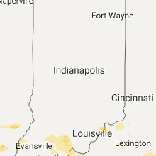
Hail Map for Saturday, May 27, 2017

Number of Impacted Households on 5/27/2017
0
Impacted by 1" or Larger Hail
0
Impacted by 1.75" or Larger Hail
0
Impacted by 2.5" or Larger Hail
Square Miles of Populated Area Impacted on 5/27/2017
0
Impacted by 1" or Larger Hail
0
Impacted by 1.75" or Larger Hail
0
Impacted by 2.5" or Larger Hail


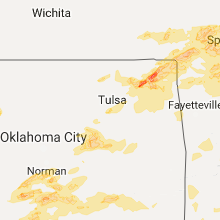


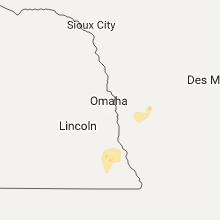

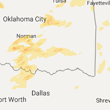
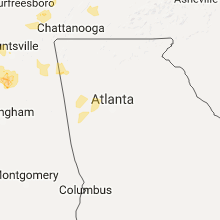


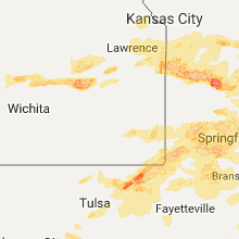

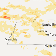
Cities Most Affected by Hail Storms of 5/27/2017
| Hail Size | Demographics of Zip Codes Affected | ||||||
|---|---|---|---|---|---|---|---|
| City | Count | Average | Largest | Pop Density | House Value | Income | Age |
| Carthage, MO | 5 | 2.10 | 2.50 | 133 | $67k | $31.0k | 35.5 |
| Beaver, OK | 3 | 2.17 | 2.75 | 2 | $58k | $38.0k | 41.8 |
| Duncan, OK | 3 | 2.08 | 2.75 | 88 | $61k | $31.6k | 40.0 |
| Adrian, MO | 2 | 3.00 | 4.25 | 26 | $68k | $35.3k | 41.0 |
| Purcell, OK | 2 | 2.88 | 4.00 | 82 | $66k | $34.7k | 37.5 |
| Elmore City, OK | 2 | 2.75 | 2.75 | 12 | $40k | $26.4k | 42.3 |
| Clinton, MO | 3 | 1.83 | 2.00 | 53 | $72k | $30.6k | 44.1 |
| Marion, VA | 3 | 1.83 | 2.00 | 137 | $70k | $30.2k | 43.3 |
| Galena, KS | 3 | 1.75 | 1.75 | 80 | $44k | $30.6k | 41.0 |
| Morse, TX | 2 | 2.63 | 2.75 | 1 | $38k | $36.9k | 44.5 |
| Bunker, MO | 2 | 2.50 | 3.00 | 4 | $45k | $21.9k | 43.8 |
| Chelsea, OK | 2 | 2.25 | 2.50 | 40 | $56k | $32.7k | 39.4 |
| Vinita, OK | 2 | 2.25 | 2.75 | 27 | $57k | $30.5k | 42.7 |
| Archie, MO | 2 | 2.13 | 2.50 | 38 | $79k | $39.1k | 36.1 |
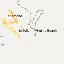
| Henrico, VA | 2 | 2.00 | 2.00 | 2681 | $121k | $47.8k | 38.3 |
| Fairland, OK | 2 | 2.00 | 2.00 | 38 | $59k | $29.3k | 43.1 |
| Stratford, TX | 2 | 1.88 | 2.00 | 0 | $47k | $32.3k | 36.3 |
| Chester, VA | 2 | 1.88 | 2.00 | 1465 | $125k | $56.8k | 37.4 |
| Saltville, VA | 2 | 1.75 | 1.75 | 36 | $52k | $28.6k | 44.0 |
| Olpe, KS | 2 | 1.75 | 1.75 | 5 | $72k | $40.6k | 42.9 |
| Greenfield, MO | 2 | 1.75 | 1.75 | 28 | $60k | $25.9k | 47.6 |
| Castle, OK | 1 | 3.00 | 3.00 | 11 | $38k | $29.9k | 42.6 |
| Okemah, OK | 1 | 2.75 | 2.75 | 19 | $42k | $23.8k | 40.2 |
| Hooker, OK | 1 | 2.75 | 2.75 | 3 | $62k | $36.1k | 32.9 |
| Balko, OK | 1 | 2.75 | 2.75 | 2 | $64k | $36.8k | 38.5 |
| Lone Grove, OK | 1 | 2.50 | 2.50 | 39 | $58k | $31.3k | 35.7 |
| Crewe, VA | 1 | 2.50 | 2.50 | 53 | $71k | $32.0k | 41.8 |
| Butler, MO | 1 | 2.50 | 2.50 | 25 | $62k | $30.5k | 42.2 |
| Bluejacket, OK | 1 | 2.50 | 2.50 | 10 | $42k | $32.7k | 41.3 |
| Lockwood, MO | 1 | 2.50 | 2.50 | 11 | $50k | $28.1k | 42.2 |
| Sharon, OK | 1 | 2.50 | 2.50 | 10 | $54k | $40.8k | 37.8 |
| Crossville, TN | 1 | 2.25 | 2.25 | 199 | $85k | $28.6k | 42.4 |
| Sulphur, OK | 1 | 2.25 | 2.25 | 43 | $53k | $30.6k | 41.9 |
| Deepwater, MO | 1 | 2.00 | 2.00 | 21 | $58k | $28.7k | 50.6 |
| Centerville, MO | 1 | 2.00 | 2.00 | 6 | $39k | $24.2k | 43.9 |
| Big Cabin, OK | 1 | 2.00 | 2.00 | 26 | $57k | $32.2k | 42.1 |
| Bristow, OK | 1 | 2.00 | 2.00 | 29 | $53k | $29.5k | 39.6 |
| Van Buren, MO | 1 | 2.00 | 2.00 | 6 | $60k | $24.6k | 45.4 |
| Richmond, VA | 1 | 2.00 | 2.00 | 2175 | $64k | $11.3k | 27.5 |
| Turpin, OK | 1 | 2.00 | 2.00 | 6 | $83k | $37.5k | 37.2 |
| English, IN | 1 | 1.75 | 1.75 | 24 | $60k | $29.3k | 42.2 |
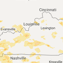
| Cerulean, KY | 1 | 1.75 | 1.75 | 20 | $70k | $35.9k | 39.3 |
| Lesterville, MO | 1 | 1.75 | 1.75 | 7 | $62k | $28.5k | 45.0 |
| Cookeville, TN | 1 | 1.75 | 1.75 | 168 | $94k | $35.4k | 41.1 |
| Noble, OK | 1 | 1.75 | 1.75 | 165 | $68k | $35.4k | 36.9 |
| Kevil, KY | 1 | 1.75 | 1.75 | 42 | $69k | $37.3k | 41.2 |
| Wayne, OK | 1 | 1.75 | 1.75 | 16 | $44k | $30.8k | 41.5 |
| Bolivar, MO | 1 | 1.75 | 1.75 | 88 | $86k | $29.9k | 34.5 |
| Grovespring, MO | 1 | 1.75 | 1.75 | 17 | $46k | $29.1k | 42.2 |
| Ada, OK | 1 | 1.75 | 1.75 | 101 | $62k | $27.0k | 34.4 |
| Fredericktown, MO | 1 | 1.75 | 1.75 | 30 | $56k | $26.0k | 40.7 |
| Wallingford, KY | 1 | 1.75 | 1.75 | 24 | $55k | $26.0k | 40.8 |
| Dalhart, TX | 1 | 1.75 | 1.75 | 5 | $63k | $33.1k | 36.5 |
| Eckerty, IN | 1 | 1.75 | 1.75 | 28 | $64k | $41.3k | 45.2 |
| Springfield, MO | 1 | 1.75 | 1.75 | 449 | $69k | $29.0k | 36.7 |
| Mc Leansboro, IL | 1 | 1.75 | 1.75 | 27 | $48k | $28.6k | 42.5 |
| Duenweg, MO | 1 | 1.75 | 1.75 | 0 | $46k | $26.8k | 37.2 |
| Poplar Bluff, MO | 1 | 1.75 | 1.75 | 111 | $62k | $27.4k | 39.9 |
| Goodwell, OK | 1 | 1.75 | 1.75 | 1 | $73k | $34.1k | 22.8 |
| Melvern, KS | 1 | 1.75 | 1.75 | 11 | $55k | $39.9k | 43.9 |
| Galena, MO | 1 | 1.75 | 1.75 | 41 | $84k | $31.3k | 46.7 |
| Bartlesville, OK | 1 | 1.75 | 1.75 | 122 | $37k | $25.8k | 36.8 |
| Bonnots Mill, MO | 1 | 1.75 | 1.75 | 25 | $100k | $43.6k | 39.5 |
| La Junta, CO | 1 | 1.75 | 1.75 | 19 | $69k | $30.5k | 39.2 |
| Coalgate, OK | 1 | 1.75 | 1.75 | 10 | $36k | $23.6k | 41.6 |
| Hodgen, OK | 1 | 1.75 | 1.75 | 3 | $40k | $23.8k | 41.0 |
| Marlow, OK | 1 | 1.75 | 1.75 | 39 | $50k | $28.9k | 41.5 |
| Olive Hill, KY | 1 | 1.75 | 1.75 | 45 | $52k | $23.6k | 40.0 |
| Chesterfield, VA | 1 | 1.75 | 1.75 | 899 | $113k | $61.7k | 36.7 |
| Nowata, OK | 1 | 1.75 | 1.75 | 28 | $43k | $27.2k | 42.1 |
| Glen Allen, VA | 1 | 1.75 | 1.75 | 2336 | $136k | $60.6k | 37.4 |
| Wyandotte, OK | 1 | 1.75 | 1.75 | 33 | $52k | $30.6k | 42.7 |
Hail and Wind Damage Spotted on 5/27/2017
Filter by Report Type:Hail ReportsWind Reports
States Impacted
North Carolina, Georgia, Kansas, Missouri, West Virginia, Kentucky, Illinois, Indiana, Virginia, Tennessee, Colorado, New Mexico, Iowa, Ohio, Oklahoma, Texas, Arkansas, Alabama, MississippiNorth Carolina
| Local Time | Report Details |
|---|---|
| 12:20 PM EDT | Several trees down across mainly the western half of buncombe count in buncombe county NC, 49.1 miles N of Greenville, SC |
| 9:00 PM EDT | Tree down on highway 158 in murfreesbor in hertford county NC, 61.3 miles WSW of Virginia Beach, VA |
| 10:48 PM EDT | Dukn7 nos c-man station on duck pier reported a 69 mph wind gusts at 1048 pm in dare county NC, 44.5 miles SSE of Virginia Beach, VA |
| 11:30 PM EDT | Swain county 911 reports numerous calls of multiple trees down around the county with a concentration in and around bryson cit in swain county NC, 45.2 miles SE of Knoxville, TN |
| 11:40 PM EDT | County 911 reports downed trees all around the count in jackson county NC, 51.1 miles NW of Greenville, SC |
| 11:44 PM EDT | Several trees down across the count in cherokee county NC, 60.3 miles S of Knoxville, TN |
| 11:55 PM EDT | County 911 reports downed trees all around the count in jackson county NC, 51.1 miles NW of Greenville, SC |
| 11:55 PM EDT | County reports widespread trees down throughout the count in macon county NC, 50.3 miles WNW of Greenville, SC |
| 12:15 AM EDT | County reports trees and powerlines down countywide but with a heavy concentration in the highway 276 jonathan creek are in haywood county NC, 55.6 miles NNW of Greenville, SC |
| 12:15 AM EDT | County reports trees and power lines down throughout the county with widespread power outages. hardest hit areas include hot springs...marshall...laurel...mars hil in madison county NC, 60.3 miles SSW of Bristol, TN |
| 12:15 AM EDT | County reports trees...branches...and leaf litter covering wildwood driv in transylvania county NC, 26.6 miles NW of Greenville, SC |
| 12:20 AM EDT | Several trees down across mainly the western half of buncombe count in buncombe county NC, 49.1 miles N of Greenville, SC |
| 12:25 AM EDT | Yancey county 911 call center reports widespread tree damage across the county... especially along u.s. 1 in yancey county NC, 46.5 miles S of Bristol, TN |
| 12:31 AM EDT | Public reported strong winds felled a 60ft hickory tree which clipped a home on sam greene rd. near arbuckle rd. and nc 8 in yancey county NC, 45.8 miles S of Bristol, TN |
| 12:40 AM EDT | County reports scattered trees down countywide with a few in hendersonvill in henderson county NC, 34.6 miles NNE of Greenville, SC |
| 12:40 AM EDT | One tree blown down along highway 221 nort in mcdowell county NC, 56.3 miles S of Bristol, TN |
| 12:55 AM EDT | Scattered trees down on powerlines around county but with a greater concentration in the west end especially lake lure are in rutherford county NC, 51.4 miles NE of Greenville, SC |
| 1:15 AM EDT | County reports scattered trees and power lines down around count in burke county NC, 60.3 miles NW of Charlotte, NC |
| 1:32 AM EDT | County reports a few trees down around polkvill in cleveland county NC, 47.3 miles WNW of Charlotte, NC |
| 2:10 AM EDT | Multiple trees and power lines down. relayed by amateur radio. time estimate in catawba county NC, 26.1 miles NNW of Charlotte, NC |
| 2:10 AM EDT | Several large trees down. location and time estimate in lincoln county NC, 23.8 miles NNW of Charlotte, NC |
| 2:15 AM EDT | Widespread trees down around the count in iredell county NC, 39.2 miles N of Charlotte, NC |
| 2:15 AM EDT | Tree down on house. relayed by amateur radio. time estimate in catawba county NC, 26.8 miles NNW of Charlotte, NC |
| 2:55 AM EDT | One tree was reported down on a residence along seven oaks driv in davidson county NC, 43.5 miles NE of Charlotte, NC |
| 3:00 AM EDT | One tree was reported down across becks church road near briggstown roa in davidson county NC, 50.8 miles NE of Charlotte, NC |
Georgia
| Local Time | Report Details |
|---|---|
| 12:25 PM EDT | Tree and power line down with a transformer fire on murray cove roa in rabun county GA, 47.2 miles W of Greenville, SC |
| 11:16 PM EDT | Report of 1 tree down near the intersection of three notch rd and buster ridge lane in catoosa county GA, 11.9 miles SE of Chattanooga, TN |
| 11:30 PM EDT | Report of a tree blown down on mantooth rd south of halls chapel rd in murray county GA, 32.8 miles ESE of Chattanooga, TN |
| 12:25 AM EDT | Tree and power line down with a transformer fire on murray cove roa in rabun county GA, 47.2 miles W of Greenville, SC |
Kansas
| Local Time | Report Details |
|---|---|
| 11:34 AM CDT | Quarter sized hail reported near Lebo, KS, 53.3 miles NNW of Chanute, KS, subway restaurant reported several quarter size hail stones. |
| 11:45 AM CDT | Golf Ball sized hail reported near Melvern, KS, 54.5 miles N of Chanute, KS, lots of golf ball size hail stones. |
| 11:50 AM CDT | Large limbs down in johnson county KS, 27.5 miles SW of Kansas City, MO |
| 11:55 AM CDT | Power lines reported down near 199th st and woodland rd in spring hill in johnson county KS, 26.3 miles SSW of Kansas City, MO |
| 12:05 PM CDT | Quarter sized hail reported near Rantoul, KS, 47.3 miles SW of Kansas City, MO, a few quarter size stones. |
| 12:12 PM CDT | Quarter sized hail reported near Stilwell, KS, 23.6 miles SSW of Kansas City, MO, quarter size hail reported near 199th st. and hwy 69 |
| 12:13 PM CDT | Damage reported to fences... power lines down... and numerous small limbs approx. 1 to 2 inches in diameter down roughly between hwy 69 and stateline and from 223rd to in miami county KS, 28 miles S of Kansas City, MO |
| 12:30 PM CDT | Quarter sized hail reported near Saint Paul, KS, 17.1 miles SE of Chanute, KS, per social media. |
| 12:52 PM CDT | Quarter sized hail reported near Ellinwood, KS, 53.8 miles SE of Hays, KS, per social media |
| 1:03 PM CDT | Quarter sized hail reported near Chase, KS, 63.8 miles ESE of Hays, KS |
| 1:06 PM CDT | Damage northeast of mccune. reports of a barn blown over. metal across the field. there was some flash flooding but minor. via social media. time estimated based on rad in crawford county KS, 33 miles SE of Chanute, KS |
| 1:25 PM CDT | Ping Pong Ball sized hail reported near Lyons, KS, 62.7 miles NW of Wichita, KS |
| 2:10 PM CDT | Ping Pong Ball sized hail reported near Galva, KS, 45 miles N of Wichita, KS, trained spotter reports quarter to ping pong ball sized hail which covered the ground. the hail lasted for five minutes. time is estimated from radar. |
| 3:40 PM CDT | Quarter sized hail reported near Olpe, KS, 61.7 miles S of Manhattan, KS, on the kansas turnpike at the lyon county line. accompanied by 60-70 mph wind. |
| 3:42 PM CDT | Golf Ball sized hail reported near Olpe, KS, 58.1 miles NW of Chanute, KS |
| 3:43 PM CDT | Estimated 60-70 mph gust on the kansas turnpike at the lyon county line. accompanied by quarter size hai in lyon county KS, 61.7 miles S of Manhattan, KS |
| 3:55 PM CDT | Quarter sized hail reported near Olpe, KS, 55.9 miles NW of Chanute, KS, video evidence suggests hail at least the size of quarters fell in olpe. |
| 3:55 PM CDT | Golf Ball sized hail reported near Olpe, KS, 52.8 miles NW of Chanute, KS, hail up to golfball size. ground totally covered. hail dented the spotters truck. |
| 7:44 PM CDT | Quarter sized hail reported near Elkhart, KS, 85.9 miles SW of Garden City, KS |
| 7:46 PM CDT | Storm damage reported in morton county KS, 85.9 miles SW of Garden City, KS |
| 7:48 PM CDT | Quarter sized hail reported near Elkhart, KS, 88 miles SW of Garden City, KS |
| 7:50 PM CDT | Half Dollar sized hail reported near Elkhart, KS, 83.9 miles SW of Garden City, KS |
| 7:50 PM CDT | Half Dollar sized hail reported near Elkhart, KS, 87.1 miles SW of Garden City, KS, via photo verification on social media. |
| 7:50 PM CDT | Storm damage reported in morton county KS, 83.9 miles SW of Garden City, KS |
| 8:20 PM CDT | Storm damage reported in stevens county KS, 73 miles SSW of Garden City, KS |
| 12:15 AM CDT | Golf Ball sized hail reported near Galena, KS, 65.3 miles SE of Chanute, KS, golfball size hail reported at downstream casino |
| 12:15 AM CDT | Golf Ball sized hail reported near Galena, KS, 65.7 miles SE of Chanute, KS, golf ball size hail at the state line and downstream casino. |
| 12:20 AM CDT | Golf Ball sized hail reported near Galena, KS, 62.3 miles SE of Chanute, KS, golfball size hail reported near galena. |
Missouri
| Local Time | Report Details |
|---|---|
| 12:18 PM CDT | Half Dollar sized hail reported near Fort Leonard Wood, MO, 34.6 miles W of Salem, MO, half dollar size hail. time based on radar. report via internet. |
| 12:23 PM CDT | Storm damage reported in cass county MO, 19.7 miles S of Kansas City, MO |
| 12:36 PM CDT | Tennis Ball sized hail reported near Archie, MO, 44.8 miles SSE of Kansas City, MO, delayed report...photo of tennis ball sized hail in archie |
| 12:36 PM CDT | Delayed report of trees down on barn and fence... 12 inches and 20 plus inches in diameter... respectivel in cass county MO, 29.5 miles SSE of Kansas City, MO |
| 12:39 PM CDT | Branches breaking in cass county MO, 33.7 miles SSE of Kansas City, MO |
| 12:40 PM CDT | Estimated 60mph gusts at wfo eax in cass county MO, 27.4 miles SE of Kansas City, MO |
| 12:46 PM CDT | Golf Ball sized hail reported near Archie, MO, 44.9 miles SSE of Kansas City, MO, golfball size hail reported at conoco in archie |
| 12:46 PM CDT | Also reported dime size hai in bates county MO, 50.4 miles SSE of Kansas City, MO |
| 12:47 PM CDT | Quarter sized hail reported near Archie, MO, 42.1 miles SSE of Kansas City, MO, i-49 and 327th street |
| 12:51 PM CDT | Golf Ball sized hail reported near Adrian, MO, 50.1 miles SSE of Kansas City, MO |
| 12:52 PM CDT | Quarter sized hail reported near Rolla, MO, 18.8 miles NW of Salem, MO, dime to almost quarter size hail between 63 and o highway at the phelps/dent county line. |
| 1:02 PM CDT | Grapefruit sized hail reported near Adrian, MO, 52.8 miles SSE of Kansas City, MO, bates county sheriff called to report several reports of softball size hail east of adrian |
| 1:03 PM CDT | Tennis Ball sized hail reported near Butler, MO, 55.7 miles SSE of Kansas City, MO, broadcast media reported tennis ball size hail in ballard |
| 1:05 PM CDT | Quarter sized hail reported near Lamar, MO, 53.1 miles WNW of Springfield, MO, barton county quater size hail reported at a hwy and 160 hwy. |
| 1:08 PM CDT | Half Dollar sized hail reported near Creighton, MO, 50 miles SSE of Kansas City, MO, about quarter to half dollar size hail reported at conoco |
| 1:08 PM CDT | Trees damaged in urich. reported via e in henry county MO, 54.4 miles SE of Kansas City, MO |
| 1:10 PM CDT | Quarter sized hail reported near Greenfield, MO, 31.4 miles WNW of Springfield, MO, 1.00 inch hail. time based on radar. via internet submission. |
| 1:20 PM CDT | Trees down on ucm campus in johnson county MO, 51.7 miles ESE of Kansas City, MO |
| 1:20 PM CDT | An 8 inch tree reported down approximately 1 mile nw of state hwy oo and business route 13 in johnson county MO, 48.4 miles ESE of Kansas City, MO |
| 1:21 PM CDT | Large tree down in brazit in cole county MO, 35.4 miles S of Columbia, MO |
| 1:24 PM CDT | Report of tree branches at least 3 inches in diameter and larger down near college and culton streets... blocking some flow of traffic in johnson county MO, 51.2 miles ESE of Kansas City, MO |
| 1:25 PM CDT | Large tree uprooted in the town of clinton in henry county MO, 66.6 miles SE of Kansas City, MO |
| 1:29 PM CDT | Large tree limbs down in henry county MO, 67 miles SE of Kansas City, MO |
| 1:30 PM CDT | Ping Pong Ball sized hail reported near Salem, MO, 0.3 miles NW of Salem, MO, ping pong hail in salem... mo. |
| 1:33 PM CDT | Golf Ball sized hail reported near Clinton, MO, 68.2 miles SE of Kansas City, MO |
| 1:33 PM CDT | Storm damage reported in henry county MO, 68.2 miles SE of Kansas City, MO |
| 1:40 PM CDT | Quarter sized hail reported near Jefferson City, MO, 33.1 miles SSE of Columbia, MO |
| 1:48 PM CDT | Quarter sized hail reported near Green Ridge, MO, 62.4 miles WSW of Columbia, MO, reported at caseys general store |
| 1:48 PM CDT | Hen Egg sized hail reported near Clinton, MO, 74.4 miles NNW of Springfield, MO, report from em of several vehichles with windshields broken out due to hail at the bucksaw marina. hail size unknown. |
| 1:53 PM CDT | Quarter sized hail reported near Clinton, MO, 77.2 miles N of Springfield, MO, spotter measured at least quarter size hail covering the ground. thinks that hail could have been larger as it broke a windvisor on a truck. |
| 1:53 PM CDT | Hen Egg sized hail reported near Deepwater, MO, 72.4 miles N of Springfield, MO |
| 1:53 PM CDT | Wind took out the weather station of the spotter as well as brought down several tree limbs approximately 5 inches in diameter or so near the intersection of mo-pp and in henry county MO, 77.1 miles N of Springfield, MO |
| 1:54 PM CDT | Golf Ball sized hail reported near Clinton, MO, 75.9 miles NNW of Springfield, MO, windshield broken on truck |
| 1:55 PM CDT | Measured by storm chaser at marshall junction in saline county MO, 47.2 miles W of Columbia, MO |
| 2:00 PM CDT | Golf Ball sized hail reported near Greenfield, MO, 34.1 miles WNW of Springfield, MO, golf ball size hail. via social media. |
| 2:10 PM CDT | Truman state park reported winds gust 60mph with nickel size hai in benton county MO, 74.3 miles N of Springfield, MO |
| 2:10 PM CDT | Quarter sized hail reported near Otterville, MO, 39.9 miles WSW of Columbia, MO |
| 2:15 PM CDT | Golf Ball sized hail reported near Bolivar, MO, 25.5 miles NNW of Springfield, MO, golf ball size hail via le. |
| 2:15 PM CDT | Hen Egg sized hail reported near Bunker, MO, 22 miles SE of Salem, MO, facebook picture of 2-inch hail in bunker... mo. |
| 2:19 PM CDT | Tea Cup sized hail reported near Bunker, MO, 21.8 miles ESE of Salem, MO, time estimated from radar.. |
| 2:30 PM CDT | Numerous tree limbs down along rt in cole county MO, 33.3 miles S of Columbia, MO |
| 2:30 PM CDT | Power-lines down near hwy13 in morgan county MO, 53.6 miles SW of Columbia, MO |
| 2:30 PM CDT | Roof or structure damage. significant damage. multiple large trees dow in morgan county MO, 51.8 miles SSW of Columbia, MO |
| 2:30 PM CDT | Numerous trees down near hwy in morgan county MO, 58.4 miles SSW of Columbia, MO |
| 2:35 PM CDT | Thunderstorm wind damage. multiple large trees are down out of the ground. via internet submissio in polk county MO, 17.4 miles N of Springfield, MO |
| 2:35 PM CDT | Power lines down in cooper county MO, 22.4 miles W of Columbia, MO |
| 2:35 PM CDT | Ping Pong Ball sized hail reported near Ash Grove, MO, 18.7 miles W of Springfield, MO, reports of ping pong sized hail and n hwy and i-44 in halltown area. |
| 2:40 PM CDT | Scattered tree damage across much of cooper county in cooper county MO, 22.8 miles W of Columbia, MO |
| 2:42 PM CDT | Trees downed and transformer caught fire. time estimated from rada in moniteau county MO, 25.6 miles SSW of Columbia, MO |
| 2:45 PM CDT | 5" diameter tree across road... nichols rd near sycamore golf course... osage beach. time based on rada in camden county MO, 59.7 miles SSW of Columbia, MO |
| 2:45 PM CDT | Quarter sized hail reported near Willard, MO, 9.9 miles NW of Springfield, MO |
| 2:50 PM CDT | Half Dollar sized hail reported near Springfield, MO, 6.2 miles WNW of Springfield, MO, at the springfield nws office. |
| 2:50 PM CDT | Golf Ball sized hail reported near Springfield, MO, 2.4 miles NNE of Springfield, MO, reported at kearney and pickwick... springfield... mo. golf ball sized hail. |
| 2:55 PM CDT | Ping Pong Ball sized hail reported near Springfield, MO, 3 miles NNW of Springfield, MO, reported at 1401 w norton rd... springfield... mo 65803. |
| 2:56 PM CDT | Winds has downed limbs in the kk are in camden county MO, 57.5 miles SSW of Columbia, MO |
| 2:56 PM CDT | Hen Egg sized hail reported near Centerville, MO, 33.6 miles ESE of Salem, MO |
| 2:59 PM CDT | Ping Pong Ball sized hail reported near Springfield, MO, 2.4 miles NNW of Springfield, MO, dime and ping pong size hail near atlantic and kansas expressway. |
| 3:00 PM CDT | Golf Ball sized hail reported near Bonnots Mill, MO, 36.2 miles SE of Columbia, MO |
| 3:00 PM CDT | Large tree down rock island park. via social medi in miller county MO, 43.6 miles SSW of Columbia, MO |
| 3:01 PM CDT | Quarter sized hail reported near Centerville, MO, 34.4 miles ESE of Salem, MO |
| 3:02 PM CDT | Quarter sized hail reported near Linn, MO, 40 miles SE of Columbia, MO |
| 3:02 PM CDT | Storm damage reported in boone county MO, 11.6 miles SSE of Columbia, MO |
| 3:03 PM CDT | Fair grove reports 68 mph wind gusts at at least 1 4inch tree dow in greene county MO, 14.1 miles NNE of Springfield, MO |
| 3:05 PM CDT | Quarter sized hail reported near Strafford, MO, 9.9 miles ENE of Springfield, MO, 305pm ..quarter sized hail...1 mi w of strafford... greene county. |
| 3:05 PM CDT | Reported at columbia regional airport. several tents blown over at airsho in boone county MO, 11 miles SE of Columbia, MO |
| 3:10 PM CDT | Quarter sized hail reported near Springfield, MO, 2.8 miles NE of Springfield, MO, reported at kearney and glenstone... springfield... mo. |
| 3:10 PM CDT | Quarter sized hail reported near Lesterville, MO, 40.6 miles ESE of Salem, MO |
| 3:13 PM CDT | Quarter sized hail reported near Lesterville, MO, 40.6 miles ESE of Salem, MO |
| 3:15 PM CDT | Trees down on mo hwy in osage county MO, 43.6 miles SSE of Columbia, MO |
| 3:15 PM CDT | Golf Ball sized hail reported near Grovespring, MO, 39.8 miles ENE of Springfield, MO, golf ball size hail with snapped trees. |
| 3:15 PM CDT | Golf Ball sized hail reported near Lesterville, MO, 40.6 miles ESE of Salem, MO, time estimated from radar. |
| 3:15 PM CDT | Time estimated from rada in reynolds county MO, 40.6 miles ESE of Salem, MO |
| 3:17 PM CDT | Trees on raodway in 3 locations. power lines blocking roadway on hwy bb and fitzpatrick... bb and allen rd. and monsees ave and b hwy. vehicle wrapped up in power lines in benton county MO, 70.2 miles SW of Columbia, MO |
| 3:18 PM CDT | Large tree was split in half with fallen portion on u.s. highway 5 in callaway county MO, 20.7 miles SE of Columbia, MO |
| 3:21 PM CDT | Tree down on long spring road near route b in crawford county MO, 25.8 miles NNE of Salem, MO |
| 3:28 PM CDT | Tree down blocking highway 63 near freeburg are in osage county MO, 49 miles SSE of Columbia, MO |
| 3:30 PM CDT | Trees snapped or uprooted... multiple trees uprooted. hail .25 to .50" in laclede county MO, 46.9 miles W of Salem, MO |
| 3:30 PM CDT | Reported at evening shade... mo. several trees uprooted. via social medi in texas county MO, 33.4 miles W of Salem, MO |
| 3:35 PM CDT | Multiple trees blocking roadways. power lines down in bell in maries county MO, 46.2 miles NNW of Salem, MO |
| 3:35 PM CDT | Multiple trees blocking road ways. power lines down in bell in benton county MO, 70.2 miles SW of Columbia, MO |
| 3:35 PM CDT | Power lines down in 100 block of cape county road 525 in cape girardeau county MO, 13.7 miles N of Cape Girardeau, MO |
| 3:35 PM CDT | Half Dollar sized hail reported near Annapolis, MO, 48.1 miles ESE of Salem, MO |
| 3:35 PM CDT | Half Dollar sized hail reported near Annapolis, MO, 48.7 miles ESE of Salem, MO |
| 3:38 PM CDT | Quarter sized hail reported near Linn, MO, 43.5 miles SE of Columbia, MO |
| 3:40 PM CDT | Trees and power lines dow in osage county MO, 46.8 miles NNW of Salem, MO |
| 3:44 PM CDT | Numerous limbs blown down as well as power lines around tow in gasconade county MO, 46 miles N of Salem, MO |
| 3:45 PM CDT | Trees uprooted and shingles off house...77.2 mph measured winds...hunters point subdivision in waynesville... pulaski count in pulaski county MO, 38.8 miles WNW of Salem, MO |
| 3:45 PM CDT | Ping Pong Ball sized hail reported near Fort Leonard Wood, MO, 36.9 miles WNW of Salem, MO, picture from social media of ping pong size hail at fort leonard wood. |
| 3:47 PM CDT | Numerous 3"-6" limbs were broke in texas county MO, 31.1 miles SW of Salem, MO |
| 3:50 PM CDT | Edgar springs area phelps county...numerous large trees down...power out all over town...building debris on the highway. time estimated based on rada in phelps county MO, 18.8 miles WNW of Salem, MO |
| 4:00 PM CDT | Numerous trees and power lines down across the city. also reports of e80 mph wind gust. numerous power outage in dent county MO, 0.9 miles NNW of Salem, MO |
| 4:00 PM CDT | Numerous trees and power lines down across the city. also reports of e80 mph wind gust. numerous power outage in dent county MO, 0.9 miles NNW of Salem, MO |
| 4:02 PM CDT | Trees down in sac in madison county MO, 50.1 miles W of Cape Girardeau, MO |
| 4:04 PM CDT | Medium sized tree snappe in franklin county MO, 44.9 miles NNE of Salem, MO |
| 4:08 PM CDT | Golf Ball sized hail reported near Fredericktown, MO, 49.3 miles W of Cape Girardeau, MO |
| 4:10 PM CDT | National park service rangers report 3 large trees across highway 19 about 1 mile north of echo bluff state par in shannon county MO, 22.8 miles SSE of Salem, MO |
| 4:15 PM CDT | Quarter sized hail reported near Bertrand, MO, 27.6 miles S of Cape Girardeau, MO, nickel to quarter sized hail |
| 4:15 PM CDT | Power lines dow in crawford county MO, 24.9 miles NNE of Salem, MO |
| 4:25 PM CDT | Tree limbs dow in iron county MO, 23 miles ENE of Salem, MO |
| 4:30 PM CDT | Trees down in reynolds county MO, 42.1 miles ESE of Salem, MO |
| 4:30 PM CDT | Between eminence and round springs there are numerous large tree limbs dow in shannon county MO, 30.4 miles SSE of Salem, MO |
| 4:35 PM CDT | A tree blown over. other small to medium sized limbs broken out of tree in st. charles county MO, 32 miles WNW of Saint Louis, MO |
| 4:35 PM CDT | Few trees dow in reynolds county MO, 39.2 miles ESE of Salem, MO |
| 4:37 PM CDT | Few trees dow in reynolds county MO, 40.6 miles ESE of Salem, MO |
| 4:40 PM CDT | Power lines blown down on mexico road near mid rivers mall driv in st. charles county MO, 25.8 miles WNW of Saint Louis, MO |
| 4:43 PM CDT | Numerous trees and power lines down along highway 21 and route in iron county MO, 48.7 miles E of Salem, MO |
| 4:50 PM CDT | Trees and power lines down between caledonia and potosi. time estimated from rada in washington county MO, 44.4 miles ENE of Salem, MO |
| 4:53 PM CDT | Time estimated from rada in washington county MO, 47.9 miles ENE of Salem, MO |
| 4:57 PM CDT | Large trees and powerlines down in bismarc in st. francois county MO, 51 miles E of Salem, MO |
| 4:59 PM CDT | Large tree blown down blocking a road south of tow in washington county MO, 48.7 miles ENE of Salem, MO |
| 5:00 PM CDT | Trees dow in st. francois county MO, 54 miles ENE of Salem, MO |
| 5:00 PM CDT | Quarter sized hail reported near Marble Hill, MO, 24.2 miles W of Cape Girardeau, MO |
| 5:00 PM CDT | Large three foot diameter tree uprooted. shingles/siding down from house. small portion of barn roof remove in madison county MO, 47.1 miles WNW of Cape Girardeau, MO |
| 5:04 PM CDT | Medium sized tree dow in st. francois county MO, 56.6 miles SSW of Saint Louis, MO |
| 5:05 PM CDT | Several trees down around town. power out to several homes and businesses including carter county sheriffs dep in carter county MO, 52 miles SE of Salem, MO |
| 5:07 PM CDT | Roof partially blown off barefoot fireworks near fredericktow in madison county MO, 45.5 miles WNW of Cape Girardeau, MO |
| 5:08 PM CDT | Numerous small to medium size tree limbs down in southwest side of farmingto in st. francois county MO, 58.7 miles NW of Cape Girardeau, MO |
| 5:08 PM CDT | Trees down in leadingto in st. francois county MO, 56.4 miles SSW of Saint Louis, MO |
| 5:13 PM CDT | Trees downed on highway 221 and 61. size unknown. billboard downed on highway 67 sout in st. francois county MO, 59.2 miles NW of Cape Girardeau, MO |
| 5:14 PM CDT | Storm damage reported in st. francois county MO, 58 miles WNW of Cape Girardeau, MO |
| 5:15 PM CDT | Also trees snapped and uproote in st. francois county MO, 55.1 miles SSW of Saint Louis, MO |
| 5:17 PM CDT | Numerous trees and power lines down across the southern part of the count in ste. genevieve county MO, 48.8 miles NW of Cape Girardeau, MO |
| 5:17 PM CDT | Trees down in marquan in madison county MO, 35.5 miles WNW of Cape Girardeau, MO |
| 5:33 PM CDT | Large tree limbs and branches down in cape girardeau county MO, 7.9 miles NW of Cape Girardeau, MO |
| 5:35 PM CDT | Large tree across road and some large limbs down in cape girardeau county MO, 11.1 miles NNE of Cape Girardeau, MO |
| 5:40 PM CDT | Very strong winds estimated to be 60 mph in perry county MO, 34.5 miles NNW of Cape Girardeau, MO |
| 5:42 PM CDT | Quarter sized hail reported near Lone Jack, MO, 27 miles SE of Kansas City, MO, quarter size hail reported in lone jack by nws employee |
| 5:45 PM CDT | Roofs blown off movie theater and car wash... roof damage to several homes in same area in stoddard county MO, 42.2 miles SSW of Cape Girardeau, MO |
| 5:45 PM CDT | Quarter sized hail reported near Webb City, MO, 63.9 miles SE of Chanute, KS, atc reported 1.00 inch hail. |
| 5:45 PM CDT | Quarter sized hail reported near Camdenton, MO, 63.6 miles NNE of Springfield, MO, 1.00 inch hail observed by trained spotter. |
| 5:45 PM CDT | Trees and pwer lines dow in wayne county MO, 51.3 miles WSW of Cape Girardeau, MO |
| 5:50 PM CDT | Damage to roof shingles. measured winds of 53 mph as storm passed in bollinger county MO, 24.1 miles W of Cape Girardeau, MO |
| 6:12 PM CDT | Quarter sized hail reported near Ash Grove, MO, 18.7 miles W of Springfield, MO, quarter size hail in halltown. |
| 6:13 PM CDT | Quarter sized hail reported near Camdenton, MO, 59.3 miles NNE of Springfield, MO, 1.00 inch hail near roach. |
| 6:18 PM CDT | Half Dollar sized hail reported near Houstonia, MO, 56.5 miles W of Columbia, MO, updated... spotter searched area and found larger hail stone as previous was 1 inch. |
| 6:18 PM CDT | Quarter sized hail reported near Houstonia, MO, 56.5 miles W of Columbia, MO |
| 6:21 PM CDT | Quarter sized hail reported near Houstonia, MO, 55.4 miles W of Columbia, MO |
| 6:21 PM CDT | Quarter sized hail reported near Lebanon, MO, 47.6 miles NE of Springfield, MO, quarter sized hail currently at laclede county oem. |
| 6:24 PM CDT | Quarter sized hail reported near Ash Grove, MO, 16.8 miles WNW of Springfield, MO, 1.00 inch hail. |
| 6:24 PM CDT | Half Dollar sized hail reported near Flemington, MO, 41.7 miles NNW of Springfield, MO, half dollar size hail. |
| 6:25 PM CDT | Ping Pong Ball sized hail reported near Flemington, MO, 42.3 miles NNW of Springfield, MO, flemington area polk county...fire reports ping pong ball sized hail... |
| 6:26 PM CDT | Measured at cwop station in mississippi county MO, 47.4 miles SSE of Cape Girardeau, MO |
| 6:29 PM CDT | Spotter is 1 miles s of republic... mo (greene county) [37.109/-93.481] -- measured 69 mph wind. 3-4 inch branches broken. power is out in southwest republi in greene county MO, 12.4 miles WSW of Springfield, MO |
| 6:30 PM CDT | Quarter sized hail reported near Exeter, MO, 51.7 miles SW of Springfield, MO, 1.00 inch hail. |
| 6:30 PM CDT | Picture from social media showed several trees down in a neighborhoo in christian county MO, 9.9 miles SSE of Springfield, MO |
| 6:38 PM CDT | Citizen reported 6-12 inch tree down on fr 78 just south of fr 78 & fr 7 in greene county MO, 12.5 miles WNW of Springfield, MO |
| 6:43 PM CDT | Multiple 6-12 inch tree limbs downed also ham radio antenna destroyed in se nixa... christian count in christian county MO, 11.7 miles S of Springfield, MO |
| 6:45 PM CDT | Power outage pierce city - spruce street area - tree blown ove in lawrence county MO, 43 miles WSW of Springfield, MO |
| 6:46 PM CDT | Second wind gust measured 63 mph. power still out in south republic. low lying areas starting to flood. many branches dow in greene county MO, 12.4 miles WSW of Springfield, MO |
| 6:47 PM CDT | Large tree down blocking hwy 97 2 miles north of pierce city in lawrence county blocking hwy north and sout in lawrence county MO, 42.5 miles WSW of Springfield, MO |
| 6:50 PM CDT | Storm damage reported in barry county MO, 40.5 miles WSW of Springfield, MO |
| 6:52 PM CDT | Sleepy hollow subdivision in nixa christian county...numerous power outages...lots of tree damage and lawn items blown around on tracker r in christian county MO, 12.3 miles S of Springfield, MO |
| 6:57 PM CDT | Ping Pong Ball sized hail reported near Lockwood, MO, 38.4 miles WNW of Springfield, MO, nickel size hail was also reported at greenfield. |
| 6:58 PM CDT | Tennis Ball sized hail reported near Lockwood, MO, 38.4 miles WNW of Springfield, MO, social media pictures of tennis ball size hail near lockwood. |
| 7:00 PM CDT | Pictures on social media showed minor roof damage to a businesses in downtown west plain in douglas county MO, 56.5 miles ESE of Springfield, MO |
| 7:00 PM CDT | Pictures on social media showed minor roof damage to a businesses in downtown west plain in howell county MO, 64.9 miles SSW of Salem, MO |
| 7:00 PM CDT | Quarter sized hail reported near Cassville, MO, 48.5 miles SW of Springfield, MO, quarter size hail on hwy 248 and fr 1155 ne of cassvillle. |
| 7:10 PM CDT | Getting numerous reports of trees down - hwy pp 2 miles north of hwy 37 between monett and pierc in lawrence county MO, 40.8 miles WSW of Springfield, MO |
| 7:10 PM CDT | Ping Pong Ball sized hail reported near Aurora, MO, 36.8 miles SW of Springfield, MO, social media picture of hail. |
| 7:11 PM CDT | Quarter sized hail reported near Hartville, MO, 43.2 miles E of Springfield, MO |
| 7:12 PM CDT | Golf Ball sized hail reported near Greenfield, MO, 33.5 miles WNW of Springfield, MO |
| 7:15 PM CDT | Battlefield fire reported multiple trees down across battlefield from west to east. fr 137 and gray rock tree down approximately 15-20 inches. tree into house at 5924 s in greene county MO, 7.5 miles SW of Springfield, MO |
| 7:15 PM CDT | Numerous trees down around ava area. one tree on a ca in douglas county MO, 38.9 miles ESE of Springfield, MO |
| 7:15 PM CDT | Ping Pong Ball sized hail reported near Everton, MO, 27.7 miles WNW of Springfield, MO, 1.50" hail. via internet. |
| 7:18 PM CDT | Quarter sized hail reported near Ava, MO, 39.4 miles ESE of Springfield, MO, quarter size hail in ava. |
| 7:20 PM CDT | Golf Ball sized hail reported near Galena, MO, 30.1 miles SSW of Springfield, MO, just west of galena. |
| 7:24 PM CDT | Quarter sized hail reported near Seneca, MO, 79.8 miles WSW of Springfield, MO |
| 7:25 PM CDT | Quarter sized hail reported near Seneca, MO, 76.5 miles SE of Chanute, KS |
| 7:26 PM CDT | 24 inch tree uprooted on atlanta and welch streets in nixa...also numerous trees with large limbs ripped of in christian county MO, 11.7 miles S of Springfield, MO |
| 7:30 PM CDT | Quarter sized hail reported near Walnut Grove, MO, 20.4 miles NW of Springfield, MO |
| 7:33 PM CDT | Storm damage reported in barry county MO, 43.5 miles SW of Springfield, MO |
| 7:33 PM CDT | Trees down lawrence 1030 north of 2210 in pierce city area; also report of tree on vehicle at residence at 303 phelps in pierce city - property damage only - no injurie in lawrence county MO, 43 miles WSW of Springfield, MO |
| 7:47 PM CDT | Quarter sized hail reported near Racine, MO, 71.7 miles WSW of Springfield, MO |
| 7:47 PM CDT | Quarter sized hail reported near Redford, MO, 41.2 miles ESE of Salem, MO |
| 7:53 PM CDT | Trees down in galena and cran in stone county MO, 29 miles SSW of Springfield, MO |
| 7:54 PM CDT | Quarter sized hail reported near Neosho, MO, 63.8 miles WSW of Springfield, MO |
| 7:56 PM CDT | Quarter sized hail reported near Neosho, MO, 62.2 miles WSW of Springfield, MO |
| 7:56 PM CDT | Hen Egg sized hail reported near Van Buren, MO, 58.6 miles SSE of Salem, MO, hail slightly larger than golfballs. |
| 7:58 PM CDT | Quarter sized hail reported near Ellsinore, MO, 63.6 miles SE of Salem, MO, on hwy 21 near hwy 60 between hunter and ellsinore |
| 8:05 PM CDT | Quarter sized hail reported near Ellsinore, MO, 65.2 miles SE of Salem, MO, on hwy 60 near town |
| 8:10 PM CDT | Quarter sized hail reported near West Plains, MO, 61.9 miles SSW of Salem, MO, mping report of quarter size hail northeast of west plains. |
| 8:20 PM CDT | Ping Pong Ball sized hail reported near Poplar Bluff, MO, 61.8 miles WSW of Cape Girardeau, MO |
| 8:30 PM CDT | Trees were blown dow in fulton county AR, 78.4 miles S of Salem, MO |
| 8:35 PM CDT | Golf Ball sized hail reported near Poplar Bluff, MO, 58.6 miles SW of Cape Girardeau, MO |
| 8:38 PM CDT | Quarter sized hail reported near Thayer, MO, 77 miles S of Salem, MO, several trees down and quarter size hail. |
| 8:50 PM CDT | Half Dollar sized hail reported near Parma, MO, 50.1 miles SSW of Cape Girardeau, MO |
| 8:50 PM CDT | Quarter sized hail reported near Exeter, MO, 51.7 miles SW of Springfield, MO |
| 8:55 PM CDT | Quarter sized hail reported near Iberia, MO, 49.4 miles WNW of Salem, MO, nickel to quarter size hail near iberia. |
| 10:00 PM CDT | Quarter sized hail reported near Kennett, MO, 75.9 miles N of Memphis, TN |
| 10:16 PM CDT | Numerous trees dow in pemiscot county MO, 63.5 miles NNE of Memphis, TN |
| 12:29 AM CDT | Quarter sized hail reported near Joplin, MO, 65.6 miles SE of Chanute, KS, fire department reports quarter size hail near iron gates. |
| 12:33 AM CDT | Quarter sized hail reported near Joplin, MO, 66.4 miles SE of Chanute, KS, several reports of quarter size hail around the joplin area. |
| 12:34 AM CDT | Quarter sized hail reported near Joplin, MO, 66.5 miles W of Springfield, MO, mping report of quarter size hail on i-44 and rangeline road. |
| 12:39 AM CDT | Golf Ball sized hail reported near Duenweg, MO, 62.9 miles W of Springfield, MO, golfball size hail reported at gas station near highway 249 and highway 66. |
| 12:46 AM CDT | Tennis Ball sized hail reported near Carthage, MO, 57.3 miles W of Springfield, MO, *** 1 inj *** there was one minor injury reported at the drive in on the west side of town due to broken glass from windows being knocked out from large hail. |
| 12:46 AM CDT | Golf Ball sized hail reported near Carthage, MO, 57.3 miles W of Springfield, MO, reported by carthage fire department nar imperial and highway 171. |
| 12:50 AM CDT | Hen Egg sized hail reported near Carthage, MO, 56.3 miles W of Springfield, MO, spotter network report near carthage. |
| 12:50 AM CDT | Tennis Ball sized hail reported near Carthage, MO, 56.2 miles W of Springfield, MO, tennis ball hail knocked out law enforcement car windows and damage to vehicles in carthage. |
| 1:00 AM CDT | Golf Ball sized hail reported near Carthage, MO, 52.3 miles W of Springfield, MO, mping report of golf ball hail. |
West Virginia
| Local Time | Report Details |
|---|---|
| 3:02 PM EDT | 1 tree down on louise ave. time estimated from rada in doddridge county WV, 56.1 miles WNW of Elkins, WV |
Kentucky
| Local Time | Report Details |
|---|---|
| 3:40 PM EDT | Quarter sized hail reported near Danville, KY, 47 miles W of Irvine, KY |
| 4:15 PM EDT | Quarter sized hail reported near Clay City, KY, 11.3 miles NNE of Irvine, KY |
| 3:20 PM CDT | Quarter sized hail reported near Wickliffe, KY, 34.4 miles SE of Cape Girardeau, MO |
| 4:50 PM EDT | Quarter sized hail reported near Irvine, KY, 0.3 miles E of Irvine, KY |
| 3:55 PM CDT | Golf Ball sized hail reported near Kevil, KY, 39.2 miles ESE of Cape Girardeau, MO, hail ranging from nickel sized to a few golfballs |
| 4:00 PM CDT | Quarter sized hail reported near Paducah, KY, 47 miles ESE of Cape Girardeau, MO, up to 1.25 inch hail |
| 5:14 PM EDT | Golf Ball sized hail reported near Wallingford, KY, 57.5 miles NNE of Irvine, KY, time estimated by radar. photo posted on social media. |
| 4:20 PM CDT | Quarter sized hail reported near Cadiz, KY, 68.3 miles NE of Mc Kenzie, TN, near exit 65 on i-24. |
| 5:25 PM EDT | A large limb was blown dow in breathitt county KY, 35.2 miles ESE of Irvine, KY |
| 5:27 PM EDT | Quarter sized hail reported near Jackson, KY, 35.7 miles ESE of Irvine, KY, report via social media and time of the event estimated from radar data. |
| 4:35 PM CDT | Golf Ball sized hail reported near Cerulean, KY, 70.6 miles S of Evansville, IN |
| 4:45 PM CDT | Unoccupied house trailer blown off foundation on hwy 91 in christian county KY, 70.3 miles S of Evansville, IN |
| 5:48 PM EDT | Quarter sized hail reported near Bonnyman, KY, 49.4 miles ESE of Irvine, KY, report via social media with event time estimated from radar data. |
| 4:50 PM CDT | Exit 17 on pennyrile parkway in christian county KY, 64.5 miles NW of Nashville, TN |
| 4:50 PM CDT | One lane of madisonville road has been blocked by a downed tree near covered wagon road in christian county KY, 66.2 miles S of Evansville, IN |
| 5:56 PM EDT | Quarter sized hail reported near Somerset, KY, 48.1 miles SSW of Irvine, KY |
| 6:00 PM EDT | Half Dollar sized hail reported near Somerset, KY, 51.6 miles SSW of Irvine, KY |
| 5:07 PM CDT | Several trees and power poles dow in lyon county KY, 67.9 miles NNE of Mc Kenzie, TN |
| 6:10 PM EDT | Quarter sized hail reported near Campbellsville, KY, 47.5 miles SSE of Louisville, KY |
| 6:15 PM EDT | Quarter sized hail reported near Olive Hill, KY, 60 miles NE of Irvine, KY |
| 5:15 PM CDT | Quarter sized hail reported near Bardwell, KY, 42 miles SE of Cape Girardeau, MO, dime to quarter sized hail. |
| 5:20 PM CDT | Trees down blocking ky 94 east of murra in calloway county KY, 35.1 miles NNE of Mc Kenzie, TN |
| 5:20 PM CDT | Half Dollar sized hail reported near Murray, KY, 34.7 miles NNE of Mc Kenzie, TN |
| 5:20 PM CDT | Tree blocking hwy 109 in webster county KY, 37.3 miles SSW of Evansville, IN |
| 6:20 PM EDT | Quarter sized hail reported near London, KY, 51.8 miles SSW of Irvine, KY |
| 6:25 PM EDT | Quarter sized hail reported near Olive Hill, KY, 60.3 miles NE of Irvine, KY |
| 6:25 PM EDT | Golf Ball sized hail reported near Olive Hill, KY, 60.3 miles NE of Irvine, KY, report via broadcast media with picture. |
| 6:27 PM EDT | Trees blown dow in letcher county KY, 50.3 miles NW of Bristol, TN |
| 6:27 PM EDT | Large tree down blocking both lanes of a roadwa in letcher county KY, 50.4 miles NW of Bristol, TN |
| 5:30 PM CDT | Winds of at least 60 mph estimated at mile marker 10 on hwy 41a in hopkins county KY, 41.5 miles S of Evansville, IN |
| 5:35 PM CDT | Electricity is ou in hopkins county KY, 51.1 miles S of Evansville, IN |
| 5:35 PM CDT | Report of tree blocking road on bethel road east of murray in calloway county KY, 35.1 miles NNE of Mc Kenzie, TN |
| 6:35 PM EDT | A tree was blown dow in letcher county KY, 47.5 miles NW of Bristol, TN |
| 5:40 PM CDT | Small limbs down as well in hopkins county KY, 44.7 miles S of Evansville, IN |
| 6:42 PM EDT | Quarter sized hail reported near Campbellsville, KY, 48.4 miles SSE of Louisville, KY |
| 5:45 PM CDT | Report of limbs down on hwy 41-a in providence and dixon and hwy 109 in diamond within the county in webster county KY, 32.3 miles SSW of Evansville, IN |
| 5:45 PM CDT | Power lines down on north main street near cates blocking travel for portion of us hwy 41 in hopkins county KY, 44 miles S of Evansville, IN |
| 5:45 PM CDT | Large tree uprooted onto home. anotehr large tree snapped off near b in hopkins county KY, 51.1 miles S of Evansville, IN |
| 5:50 PM CDT | Tree blocking road on hwy 272 behind square deal market in christian county KY, 63.1 miles NW of Nashville, TN |
| 5:50 PM CDT | Wind measured to 60 mp in hopkins county KY, 44 miles S of Evansville, IN |
| 6:55 PM EDT | A tree was blown down along ky 229. the event time is estimated from rada in knox county KY, 53.3 miles S of Irvine, KY |
| 6:00 PM CDT | 64 mph wind gust at kentucky mesonet in muhlenberg county KY, 52.5 miles SSE of Evansville, IN |
| 6:00 PM CDT | Power outages affecting large portion of town in webster county KY, 41.1 miles SSW of Evansville, IN |
| 6:10 PM CDT | Couple of trees down on hwy 181 south of elkton. another tree down on hwy 104 near tn state line in todd county KY, 45.4 miles NNW of Nashville, TN |
| 6:14 PM CDT | Quarter sized hail reported near Greensburg, KY, 51.6 miles SSE of Louisville, KY |
| 7:19 PM EDT | Quarter sized hail reported near Elk Horn, KY, 51.9 miles SSE of Louisville, KY |
| 7:19 PM EDT | Tree reported dow in taylor county KY, 51.2 miles SSE of Louisville, KY |
| 6:20 PM CDT | Tree down on brian avenue off maxon r in mccracken county KY, 47.7 miles ESE of Cape Girardeau, MO |
| 7:33 PM EDT | Trees down and roof blown off 2 miles northwest in taylor county KY, 48.4 miles SSE of Louisville, KY |
| 7:33 PM EDT | Quarter sized hail reported near London, KY, 52.7 miles SSW of Irvine, KY |
| 6:39 PM CDT | Trees reported dow in logan county KY, 39.9 miles N of Nashville, TN |
| 6:42 PM CDT | Trees down county wid in hart county KY, 43.1 miles SSW of Louisville, KY |
| 11:43 PM UTC | Powerlines were reported to have been blown dow in pulaski county KY, 49.4 miles SW of Irvine, KY |
| 6:47 PM CDT | Tree reported dow in clinton county KY, 87.3 miles SSE of Louisville, KY |
| 7:48 PM EDT | Trees were reported down along grundy road. the time of the event is estimated from radar dat in pulaski county KY, 47.3 miles SW of Irvine, KY |
| 6:54 PM CDT | Tree down on trailor on madisonville road/hwy 4 in christian county KY, 67.5 miles NW of Nashville, TN |
| 6:55 PM CDT | 65 to 70 mph wind gusts in graves county KY, 29.6 miles N of Mc Kenzie, TN |
| 7:00 PM CDT | Report of trees down at intersection of hwy 94 and robertson road/ky hwy 166 in calloway county KY, 34.6 miles NNE of Mc Kenzie, TN |
| 8:00 PM EDT | 4 trees were reported down and onto us highway 11 in bell county KY, 61.2 miles NNE of Knoxville, TN |
| 7:10 PM CDT | Several trees down along ky hwy 121 southeast of murray near new concord in calloway county KY, 40.8 miles NE of Mc Kenzie, TN |
| 8:12 PM EDT | A large tree limb was blown down onto a vehicl in laurel county KY, 47.1 miles S of Irvine, KY |
| 8:24 PM EDT | Trees reported dow in trimble county KY, 47.4 miles NNE of Louisville, KY |
| 7:30 PM CDT | Power lines down on fairview drive in christian county KY, 61.5 miles NW of Nashville, TN |
Illinois
| Local Time | Report Details |
|---|---|
| 2:42 PM CDT | Quarter sized hail reported near Mc Leansboro, IL, 53.3 miles W of Evansville, IN |
| 2:42 PM CDT | Two trees downed. one on powerlines and another on a hous in randolph county IL, 42.5 miles SE of Saint Louis, MO |
| 2:49 PM CDT | Trees and power lines dow in randolph county IL, 45.4 miles NNW of Cape Girardeau, MO |
| 2:53 PM CDT | Golf Ball sized hail reported near Mc Leansboro, IL, 53.5 miles W of Evansville, IN |
| 3:20 PM CDT | Tree down at corner of spruce and 20th street in jackson county IL, 34.1 miles NNE of Cape Girardeau, MO |
| 3:28 PM CDT | Tree down blocking highway 63 near freeburg are in st. clair county IL, 20.8 miles SE of Saint Louis, MO |
| 3:46 PM CDT | Numerous trees/limbs down in the county including route 148 on southwest side of mt vernon and between cr-1150 and veterans memorial road... where large limb on home as in jefferson county IL, 71.9 miles ESE of Saint Louis, MO |
| 3:51 PM CDT | Trees snapped or uprooted in jackson county IL, 33.9 miles NNE of Cape Girardeau, MO |
| 3:55 PM CDT | 800 homes without powe in union county IL, 20 miles ENE of Cape Girardeau, MO |
| 4:09 PM CDT | Trees over roadway in johnson county IL, 33.6 miles ENE of Cape Girardeau, MO |
| 4:15 PM CDT | Several trees down on route 45... one completely blocking the road for a time. large tree limbs down in residence yard... 10-15 shingles blown off house. neighbors had in johnson county IL, 36.8 miles ENE of Cape Girardeau, MO |
| 4:20 PM CDT | Numerous trees down across the count in johnson county IL, 36.5 miles E of Cape Girardeau, MO |
| 4:20 PM CDT | Estimated 55-70 mph wind gusts. numerous trees down across southern part of count in williamson county IL, 44.5 miles ENE of Cape Girardeau, MO |
| 5:50 PM CDT | Widespread wind damage including a collapsed garage due to tree falling on it. numerous power poles snapped across tow in union county IL, 18.2 miles NE of Cape Girardeau, MO |
| 5:53 PM CDT | Large tree and numerous limbs down near union county hospita in union county IL, 20 miles ENE of Cape Girardeau, MO |
| 5:59 PM CDT | 70 to 80 mph gust in pulaski county IL, 20.1 miles E of Cape Girardeau, MO |
| 6:00 PM CDT | Power lines down and numerous trees 5 feet in diameter down across west side of jonesboro in union county IL, 18.2 miles NE of Cape Girardeau, MO |
Indiana
| Local Time | Report Details |
|---|---|
| 3:50 PM EDT | Golf Ball sized hail reported near English, IN, 50 miles WNW of Louisville, KY |
| 4:35 PM EDT | Golf Ball sized hail reported near Eckerty, IN, 53.7 miles WNW of Louisville, KY |
| 4:44 PM EDT | Quarter sized hail reported near English, IN, 49.4 miles WNW of Louisville, KY, i-64 near the perry/crawford county line. reported by state police. |
Virginia
| Local Time | Report Details |
|---|---|
| 4:40 PM EDT | Half Dollar sized hail reported near Dillwyn, VA, 51.6 miles W of Richmond, VA, photo submitted of half-dollar size hail in andersonville. |
| 4:55 PM EDT | Quarter sized hail reported near Dillwyn, VA, 43.3 miles W of Richmond, VA, hail ranged from pea size then increased to quarter size. |
| 5:07 PM EDT | Quarter sized hail reported near Rockville, VA, 18.5 miles NNW of Richmond, VA |
| 5:22 PM EDT | Quarter sized hail reported near Farmville, VA, 40.6 miles WSW of Richmond, VA |
| 5:30 PM EDT | Half Dollar sized hail reported near Glen Allen, VA, 12.8 miles NNE of Richmond, VA |
| 5:35 PM EDT | Golf Ball sized hail reported near Glen Allen, VA, 13.6 miles NNE of Richmond, VA |
| 5:35 PM EDT | Half Dollar sized hail reported near Burkeville, VA, 33.9 miles WSW of Richmond, VA |
| 5:38 PM EDT | Tennis Ball sized hail reported near Crewe, VA, 30.9 miles WSW of Richmond, VA, hail smashed windshield and severely dented vehicle. |
| 5:39 PM EDT | Quarter sized hail reported near Drewryville, VA, 58.1 miles SSE of Richmond, VA |
| 5:40 PM EDT | Quarter sized hail reported near Jetersville, VA, 30 miles WSW of Richmond, VA |
| 5:45 PM EDT | Half Dollar sized hail reported near Henrico, VA, 8.5 miles NE of Richmond, VA |
| 5:47 PM EDT | Ping Pong Ball sized hail reported near Henrico, VA, 9.5 miles NNE of Richmond, VA |
| 5:48 PM EDT | Quarter sized hail reported near Glen Allen, VA, 13 miles NNE of Richmond, VA |
| 5:50 PM EDT | Hen Egg sized hail reported near Henrico, VA, 9.8 miles NE of Richmond, VA |
| 6:00 PM EDT | Quarter sized hail reported near Blackstone, VA, 34.4 miles SW of Richmond, VA |
| 6:00 PM EDT | Hen Egg sized hail reported near Henrico, VA, 12.2 miles NE of Richmond, VA, egg size hail lasted for 10 minutes. |
| 6:07 PM EDT | Quarter sized hail reported near Henrico, VA, 16.1 miles E of Richmond, VA |
| 6:16 PM EDT | Hen Egg sized hail reported near Richmond, VA, 12.4 miles ENE of Richmond, VA, 2 inch hail near richmond state capitol. |
| 6:25 PM EDT | Trees and power lines down near coatsvill in hanover county VA, 26.1 miles N of Richmond, VA |
| 6:30 PM EDT | Quarter sized hail reported near Church Road, VA, 24.8 miles S of Richmond, VA |
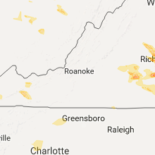
| 6:30 PM EDT | Quarter sized hail reported near Tazewell, VA, 50.2 miles NE of Bristol, TN, video report on twitter relayed by travis roberts/wvva of hail up to quarter size in thompson valley. |
| 6:34 PM EDT | Hen Egg sized hail reported near Chester, VA, 13.7 miles SE of Richmond, VA |
| 6:35 PM EDT | Ping Pong Ball sized hail reported near Chesterfield, VA, 16.1 miles SSE of Richmond, VA |
| 6:40 PM EDT | Golf Ball sized hail reported near Chesterfield, VA, 11.9 miles SE of Richmond, VA, golfball size hail in chesterfield. |
| 6:40 PM EDT | Half Dollar sized hail reported near Chesterfield, VA, 15.5 miles SE of Richmond, VA |
| 6:41 PM EDT | Golf Ball sized hail reported near Saltville, VA, 32.4 miles NE of Bristol, TN, viewer pic in saltville from david boyd/wcyb of hail ranging from ping pong to golf ball size. time estimated from radar. |
| 6:41 PM EDT | Golf Ball sized hail reported near Saltville, VA, 34.6 miles NE of Bristol, TN, viewer pic in saltville from david boyd/wcyb of hail ranging from ping pong to golf ball size. time estimated from radar. |
| 6:42 PM EDT | Ping Pong Ball sized hail reported near Saltville, VA, 33.3 miles NE of Bristol, TN, through social media. |
| 6:42 PM EDT | Ping Pong Ball sized hail reported near Saltville, VA, 32.4 miles NE of Bristol, TN, through social media. |
| 6:46 PM EDT | Half Dollar sized hail reported near Saltville, VA, 35.4 miles NE of Bristol, TN, quarter to half-dollar hail. via social media. |
| 6:47 PM EDT | Quarter sized hail reported near Chester, VA, 15.3 miles SE of Richmond, VA, quarter hail in chester. |
| 6:51 PM EDT | Quarter sized hail reported near Saltville, VA, 37.6 miles NE of Bristol, TN, in rich valley |
| 6:52 PM EDT | Golf Ball sized hail reported near Chester, VA, 17 miles SE of Richmond, VA |
| 7:05 PM EDT | Golf Ball sized hail reported near Marion, VA, 38.1 miles ENE of Bristol, TN, golf ball sized hail near the intersection of adwoolfe road and laurel springs road |
| 7:05 PM EDT | Numerous trees down in the coeburn area both on sandy ridge road and highway 5 in wise county VA, 28.3 miles NNW of Bristol, TN |
| 7:05 PM EDT | Hen Egg sized hail reported near Marion, VA, 36.9 miles ENE of Bristol, TN, via social media report. |
| 7:15 PM EDT | Quarter sized hail reported near Marion, VA, 40.5 miles ENE of Bristol, TN |
| 7:16 PM EDT | Golf Ball sized hail reported near Marion, VA, 38.5 miles ENE of Bristol, TN, golf ball sized hail on flatwoods road close to the town of thomas bridge |
| 7:30 PM EDT | Quarter sized hail reported near Nickelsville, VA, 15.5 miles NW of Bristol, TN |
| 7:39 PM EDT | Quarter sized hail reported near Drewryville, VA, 58.1 miles SSE of Richmond, VA |
| 7:43 PM EDT | Quarter sized hail reported near Drewryville, VA, 58 miles SSE of Richmond, VA, nickel to quarter size hail west of drewryville. |
| 8:08 PM EDT | Quarter sized hail reported near Drewryville, VA, 61.5 miles SSE of Richmond, VA |
| 8:15 PM EDT | Trees down along e hundred road near hopewel in chesterfield county VA, 21.8 miles ESE of Richmond, VA |
| 8:38 PM EDT | Power line and tree down near jetersville. small hail also reporte in amelia county VA, 27.1 miles WSW of Richmond, VA |
Tennessee
| Local Time | Report Details |
|---|---|
| 4:11 PM CDT | Quarter sized hail reported near Kingston Springs, TN, 19.2 miles WSW of Nashville, TN |
| 6:01 PM CDT | Tree down on bumpus mills road. time estimated based on rada in stewart county TN, 46.8 miles NE of Mc Kenzie, TN |
| 6:03 PM CDT | Quarter sized hail reported near Celina, TN, 72.9 miles ENE of Nashville, TN, nickel to quarter size hail |
| 6:05 PM CDT | Tree down at highway 79 and highway 23 in stewart county TN, 37.6 miles NE of Mc Kenzie, TN |
| 6:19 PM CDT | Several reports of trees down throughout the count in montgomery county TN, 41.8 miles NW of Nashville, TN |
| 6:27 PM CDT | 18-inch diameter tree on a house on backridge roa in montgomery county TN, 48.1 miles WNW of Nashville, TN |
| 6:38 PM CDT | Several reports of trees down countywid in houston county TN, 44.4 miles ENE of Mc Kenzie, TN |
| 6:44 PM CDT | Numerous reports of trees down throughout the count in robertson county TN, 23.6 miles NNW of Nashville, TN |
| 6:44 PM CDT | Numerous reports of trees down throughout the count in robertson county TN, 23.6 miles NNW of Nashville, TN |
| 7:10 PM CDT | Tree down blocking i-40 westbound lanes 2 miles before burns exit in dickson county TN, 27.8 miles WSW of Nashville, TN |
| 7:13 PM CDT | Several trees down in north mount juliet. tree down with roadway blocked at davids corner road and benders ferry road. trees down in roadway at 6171 saundersville road in wilson county TN, 14.8 miles ENE of Nashville, TN |
| 7:15 PM CDT | Tree fell on car on hull circle in gallatin. no injurie in sumner county TN, 23.5 miles NE of Nashville, TN |
| 7:16 PM CDT | Tree snapped at gallatin marin in sumner county TN, 23.5 miles NE of Nashville, TN |
| 7:19 PM CDT | Tree down at carothers parkway and murfreesboro road in williamson county TN, 17.9 miles S of Nashville, TN |
| 7:20 PM CDT | Several trees down on roadways across henry county... including antioch... rowe school rd... and old paris murray rd. time estimated based on rada in henry county TN, 16.4 miles NE of Mc Kenzie, TN |
| 7:22 PM CDT | Quarter sized hail reported near Cookeville, TN, 70.9 miles E of Nashville, TN |
| 7:25 PM CDT | Tree fell on vehicle on highway 69a between springville and big sand in henry county TN, 23.5 miles ENE of Mc Kenzie, TN |
| 7:26 PM CDT | Golf Ball sized hail reported near Cookeville, TN, 71.1 miles E of Nashville, TN |
| 7:27 PM CDT | Many roads were impassable due to trees down throughout the count in trousdale county TN, 37.8 miles ENE of Nashville, TN |
| 7:29 PM CDT | Tspotter report of a tree snapped on tyler cour in wilson county TN, 25.8 miles E of Nashville, TN |
| 7:30 PM CDT | 31 reports of trees and power lines down in and around lebanon with several roadways blocked. roads with trees down include 905 chaparral drive...castle heights ave...s in wilson county TN, 25.8 miles E of Nashville, TN |
| 7:41 PM CDT | Many trees down on grant roa in smith county TN, 40.2 miles E of Nashville, TN |
| 7:42 PM CDT | Tree down on highway 53 in pea ridg in clay county TN, 80.3 miles ENE of Nashville, TN |
| 7:43 PM CDT | Several large limbs down as well as a large tree down. winds estimated to be 60 mph in carroll county TN, 16.7 miles ESE of Mc Kenzie, TN |
| 7:43 PM CDT | Tree down on house and car at 245 cornwell avenue. tree in roadway at 1966 south commerce roa in wilson county TN, 36 miles E of Nashville, TN |
| 7:44 PM CDT | Tspotter report of trees down on south lovers lan in smith county TN, 37.7 miles E of Nashville, TN |
| 7:48 PM CDT | Tspotter report of trees down at defeated creek highway and kempville highwa in smith county TN, 51.2 miles ENE of Nashville, TN |
| 7:50 PM CDT | Several trees and powerlines dow in de kalb county TN, 42.3 miles E of Nashville, TN |
| 7:56 PM CDT | Downed tree blocking westbound i-4 in humphreys county TN, 40.4 miles E of Mc Kenzie, TN |
| 7:59 PM CDT | Multiple trees down along highway 264 between temperance hall and smithvill in de kalb county TN, 49.5 miles E of Nashville, TN |
| 8:00 PM CDT | Multiple trees on powerlines.... houses ...and across roadways. several vehicle accidents reporte in jackson county TN, 64.4 miles ENE of Nashville, TN |
| 8:05 PM CDT | Several trees down on highway 10 in hickman county TN, 34.7 miles WSW of Nashville, TN |
| 8:09 PM CDT | Tree on a vehicle with occupant trapped inside at county farm road and gainesboro grad in putnam county TN, 68.7 miles E of Nashville, TN |
| 8:10 PM CDT | Numerous trees and powerlines down across the western part of the count in putnam county TN, 67.1 miles E of Nashville, TN |
| 8:13 PM CDT | A significant number of trees down across the county. the most concentrated damage is in the spring creek road area near the putnam county line. some homes and vehicles in overton county TN, 72.5 miles E of Nashville, TN |
| 8:15 PM CDT | Numerous trees down in putnam county TN, 70.9 miles E of Nashville, TN |
| 8:19 PM CDT | Trees down on highway 13 in white county TN, 60.9 miles NNW of Chattanooga, TN |
| 8:19 PM CDT | Several large trees and power lines down across mountain top lane on buck mountain with roadway blocked in putnam county TN, 75.4 miles E of Nashville, TN |
| 8:21 PM CDT | Trees down on franks ferry roa in white county TN, 59 miles NNW of Chattanooga, TN |
| 8:25 PM CDT | Numerous trees and power lines down across hickman county with several roadways blocked. one tree fell on a car in pleasantville but no injurie in hickman county TN, 45.8 miles SW of Nashville, TN |
| 8:26 PM CDT | Numerous trees and power lines down across hickman county with several roadways blocked. one tree fell on a car in pleasantville but no injurie in hickman county TN, 45.8 miles SW of Nashville, TN |
| 8:26 PM CDT | A building lost its roof on north spring stree in white county TN, 61.6 miles N of Chattanooga, TN |
| 8:30 PM CDT | Structural damage to a hous in white county TN, 56.5 miles NNW of Chattanooga, TN |
| 8:33 PM CDT | Trees down at in the northwest part of the count in lewis county TN, 55.2 miles N of Florence, AL |
| 8:35 PM CDT | Trees blown down blocking the roadway at 1466 roberts ridge road in coffee county TN, 54.6 miles SE of Nashville, TN |
| 8:36 PM CDT | Several trees down and some structures damaged. some trees fell on houses and vehicle in cumberland county TN, 58.4 miles NNE of Chattanooga, TN |
| 8:40 PM CDT | Hen Egg sized hail reported near Crossville, TN, 62.7 miles W of Knoxville, TN, size of hail estimated based on image comparison to a coin. |
| 8:42 PM CDT | Structures damaged in the northern part of the count in cumberland county TN, 65.5 miles WNW of Knoxville, TN |
| 8:43 PM CDT | Trees down on hampshire pike and tindell lin in maury county TN, 43.5 miles SSW of Nashville, TN |
| 8:45 PM CDT | Several trees and power lines down across the county in fentress county TN, 63.4 miles WNW of Knoxville, TN |
| 8:50 PM CDT | Trees down across multiple roads in the county. some trees on powerlines are causing fire in maury county TN, 41.9 miles SSW of Nashville, TN |
| 10:00 PM EDT | A few trees down across the count in scott county TN, 49.7 miles NW of Knoxville, TN |
| 9:00 PM CDT | Numerous trees down across the count in bledsoe county TN, 39.3 miles N of Chattanooga, TN |
| 10:07 PM EDT | Massive trees and power lines down across the entire count in morgan county TN, 38.7 miles WNW of Knoxville, TN |
| 9:18 PM CDT | Quarter sized hail reported near Humboldt, TN, 30.7 miles SW of Mc Kenzie, TN |
| 10:20 PM EDT | Trees down across the count in roane county TN, 33.6 miles W of Knoxville, TN |
| 10:25 PM EDT | Several trees down across the count in anderson county TN, 14.7 miles NW of Knoxville, TN |
| 10:25 PM EDT | A few trees down across the count in campbell county TN, 30.6 miles NNW of Knoxville, TN |
| 9:25 PM CDT | Tree down on shelbyville highway just north of the lincoln county lin in bedford county TN, 55.4 miles SSE of Nashville, TN |
| 9:29 PM CDT | Two trees down across sequatchie count in sequatchie county TN, 22.8 miles NNW of Chattanooga, TN |
| 9:30 PM CDT | Power lines downed near rotary park. a power line was downed resulting in a fire starting in a tree at admiral circl in lawrence county TN, 36.4 miles NNE of Florence, AL |
| 9:35 PM CDT | A tree fell on a powerline on 1st stree in lawrence county TN, 36.4 miles NNE of Florence, AL |
| 10:40 PM EDT | Numerous trees and power lines down across the count in knox county TN, 1.8 miles WNW of Knoxville, TN |
| 10:40 PM EDT | Extensive damage across west knox county. cars crushed by trees... windows blown out chimney off hom in knox county TN, 3.4 miles WNW of Knoxville, TN |
| 10:43 PM EDT | Widespread trees and power lines down across the count in loudon county TN, 29 miles WSW of Knoxville, TN |
| 10:43 PM EDT | Roof off a shed in lenior city... tennesse in loudon county TN, 22.5 miles WSW of Knoxville, TN |
| 9:48 PM CDT | Tree down at 159 shelbyville hw in lincoln county TN, 68.2 miles ENE of Florence, AL |
| 10:58 PM EDT | Numerous trees down across the county. a tree fell onto a house. no injurie in mcminn county TN, 48.8 miles NE of Chattanooga, TN |
| 11:00 PM EDT | Massive trees and power lines down. several trees on home in blount county TN, 14.8 miles S of Knoxville, TN |
| 11:10 PM EDT | Widespread trees down across the count in grainger county TN, 31 miles NE of Knoxville, TN |
| 11:15 PM EDT | Numerous trees down across the count in cocke county TN, 41 miles E of Knoxville, TN |
| 10:44 PM CDT | Several trees down and uproote in madison county TN, 49.5 miles SSW of Mc Kenzie, TN |
| 11:45 PM EDT | Several trees down across the eastern part of the count in cocke county TN, 50 miles E of Knoxville, TN |
| 10:47 PM CDT | Tree down on trailer where one person was trapped for short period. time estimated based on rada in shelby county TN, 15.3 miles NE of Memphis, TN |
| 10:50 PM CDT | Tractor trailer overturned on the hernando desoto i-40 bridg in shelby county TN, 1.4 miles S of Memphis, TN |
| 11:53 PM EDT | Several trees down across the western part of the count in greene county TN, 47.8 miles SW of Bristol, TN |
| 11:00 PM CDT | Large tree down at east parkway near sam cooper blv in shelby county TN, 4.1 miles ESE of Memphis, TN |
| 11:00 PM CDT | Trees and powerlines down countywid in shelby county TN, 8 miles E of Memphis, TN |
| 11:05 PM CDT | Partial building collapse and gas leak at the 100 block of harbor town circle on mud island just north of downtown memphi in shelby county TN, 0.9 miles NW of Memphis, TN |
| 11:07 PM CDT | Large satellite dish blown off of the roof of the memphis office of emergency managemen in shelby county TN, 4.7 miles ESE of Memphis, TN |
| 11:10 PM CDT | 69 mph gust reported in downtown memphi in shelby county TN, 1.4 miles S of Memphis, TN |
| 11:12 PM CDT | 61 mph gust at memphis internationa in shelby county TN, 9 miles S of Memphis, TN |
| 12:22 AM EDT | A few trees down across the sam gap are in unicoi county TN, 42.9 miles SSW of Bristol, TN |
| 12:05 AM CDT | Tree down on house on highway 22 in michi in mcnairy county TN, 46.4 miles WNW of Florence, AL |
Colorado
| Local Time | Report Details |
|---|---|
| 3:25 PM MDT | Ping Pong Ball sized hail reported near Walsenburg, CO, 48.6 miles SSW of Pueblo, CO |
| 4:23 PM MDT | Golf Ball sized hail reported near La Junta, CO, 60.4 miles E of Pueblo, CO, reported at 32261 highway 109... cheraw... co. |
| 4:55 PM MDT | Storm damage reported in bent county CO, 75.9 miles E of Pueblo, CO |
New Mexico
| Local Time | Report Details |
|---|---|
| 4:00 PM MDT | Quarter sized hail reported near Des Moines, NM, 99.9 miles ENE of Taos, NM |
| 4:50 PM MDT | Quarter sized hail reported near Grenville, NM, 102.9 miles N of Tucumcari, NM |
| 5:46 PM MDT | Quarter sized hail reported near Grenville, NM, 102.9 miles N of Tucumcari, NM |
| 5:50 PM MDT | Quarter sized hail reported near Clayton, NM, 106.6 miles NNE of Tucumcari, NM |
Iowa
| Local Time | Report Details |
|---|---|
| 5:08 PM CDT | Half Dollar sized hail reported near Sigourney, IA, 47.4 miles SSW of Cedar Rapids, IA, just east of lake belva deer state park. quarter to half dollar size hail. |
Ohio
| Local Time | Report Details |
|---|---|
| 6:15 PM EDT | Quarter sized hail reported near Piketon, OH, 63 miles S of Columbus, OH |
| 6:16 PM EDT | A few trees were reported down on power line in pike county OH, 63.7 miles S of Columbus, OH |
| 7:30 PM EDT | Quarter sized hail reported near Cutler, OH, 73.7 miles N of Charleston, WV |
Oklahoma
| Local Time | Report Details |
|---|---|
| 6:30 PM CDT | Golf Ball sized hail reported near Bartlesville, OK, 42 miles NNW of Tulsa, OK |
| 6:30 PM CDT | Hen Egg sized hail reported near Fairland, OK, 69.9 miles SSE of Chanute, KS, time estimated by radar. |
| 6:41 PM CDT | Ping Pong Ball sized hail reported near Lone Grove, OK, 69.7 miles ENE of Wichita Falls, TX |
| 6:45 PM CDT | Golf Ball sized hail reported near Wyandotte, OK, 73.6 miles SSE of Chanute, KS |
| 6:46 PM CDT | Quarter sized hail reported near Lone Grove, OK, 69.1 miles WSW of Atoka, OK, via koco. |
| 6:47 PM CDT | Ping Pong Ball sized hail reported near Lone Grove, OK, 69.7 miles ENE of Wichita Falls, TX |
| 6:50 PM CDT | Tennis Ball sized hail reported near Lone Grove, OK, 66 miles W of Atoka, OK |
| 6:51 PM CDT | Half Dollar sized hail reported near Bartlesville, OK, 41.4 miles N of Tulsa, OK, near the airport. some damage to a vehicle and roof at a home. |
| 6:58 PM CDT | Quarter sized hail reported near Davis, OK, 58.3 miles W of Atoka, OK |
| 7:00 PM CDT | Hen Egg sized hail reported near Fairland, OK, 69.9 miles SSE of Chanute, KS, time estimated by radar. |
| 7:03 PM CDT | Quarter sized hail reported near Nowata, OK, 42.9 miles NNE of Tulsa, OK |
| 7:14 PM CDT | Half Dollar sized hail reported near Felt, OK, 107.9 miles NNW of Amarillo, TX |
| 7:16 PM CDT | Golf Ball sized hail reported near Nowata, OK, 42.7 miles NNE of Tulsa, OK, social media report. |
| 7:22 PM CDT | Half Dollar sized hail reported near Nowata, OK, 42.1 miles NNE of Tulsa, OK |
| 7:26 PM CDT | Quarter sized hail reported near Davis, OK, 57.2 miles W of Atoka, OK |
| 7:28 PM CDT | Quarter sized hail reported near Ardmore, OK, 49.2 miles W of Atoka, OK |
| 7:35 PM CDT | Hen Egg sized hail reported near Sulphur, OK, 49.4 miles W of Atoka, OK, relayed via twitter by kfor meteorologist. picture on twitter. |
| 7:37 PM CDT | Quarter sized hail reported near Ada, OK, 50.9 miles WNW of Atoka, OK |
| 7:37 PM CDT | Ping Pong Ball sized hail reported near Sulphur, OK, 49.8 miles WNW of Atoka, OK |
| 7:39 PM CDT | Quarter sized hail reported near Chelsea, OK, 41 miles NE of Tulsa, OK, on highway 28... relayed by broadcast media. |
| 7:40 PM CDT | Hen Egg sized hail reported near Chelsea, OK, 41.4 miles NE of Tulsa, OK |
| 7:45 PM CDT | Tennis Ball sized hail reported near Chelsea, OK, 41.4 miles NE of Tulsa, OK, time estimated by radar. |
| 7:45 PM CDT | Golf Ball sized hail reported near Ada, OK, 50.4 miles NW of Atoka, OK |
| 7:45 PM CDT | Half Dollar sized hail reported near Stratford, OK, 55.4 miles WNW of Atoka, OK |
| 7:47 PM CDT | Half Dollar sized hail reported near Vinita, OK, 49.6 miles NE of Tulsa, OK |
| 7:49 PM CDT | Ping Pong Ball sized hail reported near Mill Creek, OK, 39.6 miles W of Atoka, OK |
| 7:55 PM CDT | Golf Ball sized hail reported near Goodwell, OK, 91.8 miles SW of Garden City, KS, late report of golf ball size hail received via facebook. time estimated from radar. |
| 7:57 PM CDT | Half Dollar sized hail reported near Vinita, OK, 52 miles NE of Tulsa, OK |
| 7:57 PM CDT | Ping Pong Ball sized hail reported near Ada, OK, 51.3 miles NW of Atoka, OK, oil center |
| 8:00 PM CDT | Hen Egg sized hail reported near Big Cabin, OK, 50.8 miles ENE of Tulsa, OK |
| 8:00 PM CDT | Baseball sized hail reported near Duncan, OK, 52.3 miles NE of Wichita Falls, TX, half dollar to baseball size hail. |
| 8:02 PM CDT | Golf Ball sized hail reported near Marlow, OK, 53.8 miles NNE of Wichita Falls, TX |
| 8:04 PM CDT | Golf Ball sized hail reported near Duncan, OK, 52.3 miles NE of Wichita Falls, TX, spotter reports the hail is covering his yard. |
| 8:13 PM CDT | Quarter sized hail reported near Stroud, OK, 44.3 miles SW of Tulsa, OK |
| 8:13 PM CDT | Golf Ball sized hail reported near Duncan, OK, 52.6 miles NE of Wichita Falls, TX, via kswo |
| 8:13 PM CDT | Half Dollar sized hail reported near Afton, OK, 60 miles ENE of Tulsa, OK |
| 8:15 PM CDT | Half Dollar sized hail reported near Big Cabin, OK, 50.8 miles ENE of Tulsa, OK, also reported 55 mph winds. |
| 8:22 PM CDT | Quarter sized hail reported near Konawa, OK, 53.1 miles NW of Atoka, OK, relayed via twitter |
| 8:27 PM CDT | Quarter sized hail reported near Lawton, OK, 48.5 miles N of Wichita Falls, TX, via kswo |
| 8:30 PM CDT | Quarter sized hail reported near Wapanucka, OK, 20.8 miles W of Atoka, OK |
| 8:30 PM CDT | Half Dollar sized hail reported near Grove, OK, 74.7 miles ENE of Tulsa, OK |
| 8:39 PM CDT | Hen Egg sized hail reported near Bristow, OK, 42.2 miles SSW of Tulsa, OK, spotter is on highway 48 at the okfuskee and creek county line reporting heavy hail up to 2 inches in diameter. |
| 8:44 PM CDT | Quarter sized hail reported near Castle, OK, 42.8 miles SSW of Tulsa, OK, broken windshield on vehicle. |
| 8:45 PM CDT | Storm damage reported in texas county OK, 79 miles SSW of Garden City, KS |
| 8:45 PM CDT | Storm damage reported in texas county OK, 78.7 miles SSW of Garden City, KS |
| 8:45 PM CDT | Baseball sized hail reported near Hooker, OK, 78.7 miles SSW of Garden City, KS, baseball size hail reported with numerous windows broken and damage to property. |
| 8:49 PM CDT | Half Dollar sized hail reported near Wapanucka, OK, 16.2 miles W of Atoka, OK |
| 8:50 PM CDT | Storm damage reported in texas county OK, 79 miles SSW of Garden City, KS |
| 8:50 PM CDT | Quarter sized hail reported near Sapulpa, OK, 12 miles SW of Tulsa, OK |
| 8:53 PM CDT | Ping Pong Ball sized hail reported near Hooker, OK, 85.2 miles S of Garden City, KS |
| 8:53 PM CDT | Quarter sized hail reported near Sand Springs, OK, 7.4 miles WSW of Tulsa, OK |
| 8:53 PM CDT | Tea Cup sized hail reported near Castle, OK, 44 miles SSW of Tulsa, OK |
| 8:54 PM CDT | Baseball sized hail reported near Okemah, OK, 40.5 miles SSW of Tulsa, OK |
| 8:57 PM CDT | Also reported hail up to one inch in diameter... spotter located at highway 97 and 41st stree in tulsa county OK, 6.6 miles W of Tulsa, OK |
| 9:05 PM CDT | Quarter sized hail reported near Purcell, OK, 31.9 miles S of Oklahoma City, OK |
| 9:07 PM CDT | Grapefruit sized hail reported near Purcell, OK, 33.5 miles S of Oklahoma City, OK |
| 9:09 PM CDT | Hen Egg sized hail reported near Turpin, OK, 83.4 miles S of Garden City, KS |
| 9:10 PM CDT | Storm damage reported in texas county OK, 74 miles S of Garden City, KS |
| 9:13 PM CDT | Quarter sized hail reported near Purcell, OK, 31.6 miles SSE of Oklahoma City, OK, prnny to quarter hail |
| 9:13 PM CDT | Baseball sized hail reported near Balko, OK, 80.1 miles W of Woodward, OK, baseball size hail reported with damage to windows and vehicles. |
| 9:15 PM CDT | Golf Ball sized hail reported near Purcell, OK, 34 miles SSE of Oklahoma City, OK, quarter and some golfball hail. |
| 9:15 PM CDT | Half Dollar sized hail reported near Tulsa, OK, 4.3 miles ESE of Tulsa, OK, owen park in downtown tulsa. |
| 9:15 PM CDT | Ping Pong Ball sized hail reported near Tulsa, OK, 4.3 miles ESE of Tulsa, OK, observed at owen park in downtown tulsa. relayed by broadcast media. |
| 9:17 PM CDT | Powerlines down with power out in the area. some damage to property due to wind in beaver county OK, 80.1 miles W of Woodward, OK |
| 9:22 PM CDT | Numerous downed powerlines due to straightline wind in beaver county OK, 72.6 miles W of Woodward, OK |
| 9:29 PM CDT | Numerous powerlines down due to straightline wind in beaver county OK, 69.7 miles W of Woodward, OK |
| 9:30 PM CDT | Late report...18-wheeler truck blown over due to thunderstorm wind in beaver county OK, 69.7 miles W of Woodward, OK |
| 9:31 PM CDT | Golf Ball sized hail reported near Noble, OK, 31.3 miles SE of Oklahoma City, OK |
| 9:31 PM CDT | Baseball sized hail reported near Elmore City, OK, 62.2 miles S of Oklahoma City, OK |
| 9:32 PM CDT | Baseball sized hail reported near Elmore City, OK, 65.3 miles S of Oklahoma City, OK |
| 9:33 PM CDT | Golf Ball sized hail reported near Beaver, OK, 63.7 miles WNW of Woodward, OK |
| 9:33 PM CDT | Trees and powerlines downed due to thunderstorm wind gus in beaver county OK, 63.7 miles WNW of Woodward, OK |
| 9:33 PM CDT | Hen Egg sized hail reported near Beaver, OK, 63.7 miles WNW of Woodward, OK, report received via facebook. |
| 9:41 PM CDT | Broken windows in a house and car in beaver county OK, 54.9 miles W of Woodward, OK |
| 9:48 PM CDT | Quarter sized hail reported near Stroud, OK, 44.3 miles SW of Tulsa, OK |
| 9:48 PM CDT | Baseball sized hail reported near Beaver, OK, 58.3 miles W of Woodward, OK |
| 9:50 PM CDT | Storm damage reported in beaver county OK, 67.8 miles WNW of Woodward, OK |
| 9:53 PM CDT | Golf Ball sized hail reported near Coalgate, OK, 10.8 miles NNW of Atoka, OK |
| 9:55 PM CDT | Storm damage reported in beaver county OK, 67.8 miles WNW of Woodward, OK |
| 9:55 PM CDT | Storm damage reported in beaver county OK, 49.3 miles WNW of Woodward, OK |
| 9:56 PM CDT | Late report...18-wheeler blown over due to thunderstorm wind in beaver county OK, 41.1 miles WNW of Woodward, OK |
| 10:05 PM CDT | Storm damage reported in beaver county OK, 67.8 miles WNW of Woodward, OK |
| 10:09 PM CDT | Storm damage reported in okmulgee county OK, 39.6 miles S of Tulsa, OK |
| 10:09 PM CDT | Storm damage reported in murray county OK, 57.2 miles W of Atoka, OK |
| 10:17 PM CDT | Via kfor in carter county OK, 58 miles W of Atoka, OK |
| 10:20 PM CDT | Storm damage reported in beaver county OK, 49.3 miles WNW of Woodward, OK |
| 10:25 PM CDT | Storm damage reported in beaver county OK, 49.3 miles WNW of Woodward, OK |
| 10:30 PM CDT | Storm damage reported in beaver county OK, 49.3 miles WNW of Woodward, OK |
| 10:35 PM CDT | Quarter sized hail reported near Prague, OK, 44.6 miles E of Oklahoma City, OK |
| 10:35 PM CDT | Storm damage reported in pontotoc county OK, 34.8 miles WNW of Atoka, OK |
| 10:47 PM CDT | Storm damage reported in johnston county OK, 36.6 miles W of Atoka, OK |
| 10:48 PM CDT | Ping Pong Ball sized hail reported near Mill Creek, OK, 39.6 miles W of Atoka, OK |
| 10:55 PM CDT | Tennis Ball sized hail reported near Sharon, OK, 11.9 miles SSE of Woodward, OK |
| 10:55 PM CDT | Storm damage reported in woodward county OK, 1.5 miles SW of Woodward, OK |
| 11:00 PM CDT | Numerous windows blown ou in woodward county OK, 19 miles SE of Woodward, OK |
| 11:00 PM CDT | Multiple trees and power lones down on south side of coalgat in coal county OK, 11.2 miles NNW of Atoka, OK |
| 11:03 PM CDT | Quarter sized hail reported near Vinita, OK, 57.9 miles NE of Tulsa, OK |
| 11:05 PM CDT | Baseball sized hail reported near Vinita, OK, 53.9 miles NE of Tulsa, OK |
| 11:08 PM CDT | Golf Ball sized hail reported near Vinita, OK, 57.9 miles NE of Tulsa, OK |
| 11:15 PM CDT | Storm damage reported in woodward county OK, 26.1 miles SE of Woodward, OK |
| 11:25 PM CDT | Late report. three power poles snapped on highway 89 one half mile north of ringling. time estimated by rada in jefferson county OK, 55.8 miles ENE of Wichita Falls, TX |
| 11:30 PM CDT | Tree on home in sallisaw. time estimated by rada in sequoyah county OK, 21.4 miles WNW of Fort Smith, AR |
| 11:30 PM CDT | Storm damage reported in jefferson county OK, 55.8 miles ENE of Wichita Falls, TX |
| 11:33 PM CDT | Tennis Ball sized hail reported near Bluejacket, OK, 64.4 miles SSE of Chanute, KS |
| 11:49 PM CDT | Quarter sized hail reported near Miami, OK, 64.3 miles SSE of Chanute, KS |
| 11:55 PM CDT | Ping Pong Ball sized hail reported near Miami, OK, 64.3 miles SSE of Chanute, KS |
| 12:00 AM CDT | Medium size trees snapped in le flore county OK, 39.4 miles SSW of Fort Smith, AR |
| 12:20 AM CDT | Storm damage reported in carter county OK, 65.3 miles W of Atoka, OK |
| 12:25 AM CDT | Storm damage reported in pushmataha county OK, 46.6 miles ENE of Atoka, OK |
| 12:31 AM CDT | Large trees down in clayto in pushmataha county OK, 46.6 miles ENE of Atoka, OK |
| 12:41 AM CDT | Storm damage reported in le flore county OK, 53.8 miles SSW of Fort Smith, AR |
| 12:45 AM CDT | Trees and powerlines down in le flore county OK, 54.8 miles SSW of Fort Smith, AR |
| 12:50 AM CDT | Storm damage reported in le flore county OK, 56.4 miles SW of Fort Smith, AR |
| 12:57 AM CDT | Storm damage reported in garfield county OK, 63.5 miles NNW of Oklahoma City, OK |
| 1:07 AM CDT | Tree down blocking roadwa in mccurtain county OK, 52.2 miles W of Nashville, AR |
| 1:10 AM CDT | In hontunby. time estimated by rada in le flore county OK, 37 miles SSW of Fort Smith, AR |
| 1:13 AM CDT | Golf Ball sized hail reported near Hodgen, OK, 52.3 miles SSW of Fort Smith, AR |
| 1:20 AM CDT | Damage to barn... tin blown off roof in haw cree in le flore county OK, 41.1 miles S of Fort Smith, AR |
| 1:48 AM CDT | Quarter sized hail reported near Pauls Valley, OK, 53.3 miles SSE of Oklahoma City, OK |
| 1:54 AM CDT | Golf Ball sized hail reported near Wayne, OK, 42.1 miles SSE of Oklahoma City, OK |
Texas
| Local Time | Report Details |
|---|---|
| 7:41 PM CDT | Golf Ball sized hail reported near Dalhart, TX, 91.4 miles NNW of Amarillo, TX |
| 8:18 PM CDT | Golf Ball sized hail reported near Stratford, TX, 76.4 miles NNW of Amarillo, TX |
| 8:25 PM CDT | Quarter sized hail reported near Stratford, TX, 71.5 miles N of Amarillo, TX |
| 8:25 PM CDT | Ping Pong Ball sized hail reported near Stratford, TX, 71.5 miles N of Amarillo, TX, late report received via facebook. |
| 8:31 PM CDT | Hen Egg sized hail reported near Stratford, TX, 70.8 miles N of Amarillo, TX, hail dented car and cracked windshield. |
| 9:10 PM CDT | Quarter sized hail reported near Dalhart, TX, 74.8 miles NNW of Amarillo, TX |
| 9:13 PM CDT | Baseball sized hail reported near Morse, TX, 62.3 miles NNE of Amarillo, TX |
| 9:13 PM CDT | Tennis Ball sized hail reported near Morse, TX, 62.1 miles NNE of Amarillo, TX, tenniis size hail reported via twitter. |
| 9:33 PM CDT | Quarter sized hail reported near Spearman, TX, 67.3 miles NNE of Amarillo, TX |
| 9:35 PM CDT | Quarter sized hail reported near Stratford, TX, 68.7 miles N of Amarillo, TX |
| 1:20 AM CDT | Quarter sized hail reported near Saint Jo, TX, 56 miles E of Wichita Falls, TX, quarter size hail at the intersection of fm 677 and old miller rd north of nocona. |
| 2:10 AM CDT | Large sign blown down at hwy 82/fm 1417. debris on road at hwy 82/travis s in grayson county TX, 54.5 miles SSW of Atoka, OK |
| 3:44 AM CDT | Quarter sized hail reported near Gainesville, TX, 65.1 miles NNW of Dallas, TX, quarter sized hail in lindsay at intersection of main and pecan. |
Arkansas
| Local Time | Report Details |
|---|---|
| 8:47 PM CDT | Quarter sized hail reported near Hardy, AR, 90.9 miles S of Salem, MO |
| 8:50 PM CDT | A tree was blown down onto a ca in sharp county AR, 97.8 miles S of Salem, MO |
| 9:15 PM CDT | 67 mph gust recorded by awo in clay county AR, 84.5 miles SW of Cape Girardeau, MO |
| 9:15 PM CDT | 67 mph gust recorded by awo in clay county AR, 84.5 miles SW of Cape Girardeau, MO |
| 9:27 PM CDT | Power lines dow in benton county AR, 69.7 miles SW of Springfield, MO |
| 9:28 PM CDT | Tree fell on house on gum street in walnut ridg in lawrence county AR, 81.6 miles NW of Memphis, TN |
| 9:35 PM CDT | Trees blocking the road at highways 141 and 35 in greene county AR, 68.3 miles NNW of Memphis, TN |
| 9:45 PM CDT | Large metal shop roof blown off along highway 1 just south of jonesbor in craighead county AR, 58.1 miles NW of Memphis, TN |
| 9:45 PM CDT | Quarter sized hail reported near Marmaduke, AR, 74.2 miles NNW of Memphis, TN |
| 9:45 PM CDT | Trees and power lines down in west jonebor in craighead county AR, 58.7 miles NW of Memphis, TN |
| 10:00 PM CDT | Trees down in carawa in craighead county AR, 45 miles NNW of Memphis, TN |
| 10:15 PM CDT | Trees down on roads and houses in lepant in poinsett county AR, 35.5 miles NNW of Memphis, TN |
| 10:30 PM CDT | Large tree fell on house in whitto in mississippi county AR, 27.8 miles NNW of Memphis, TN |
| 10:40 PM CDT | *** 1 inj *** a large tree fell on two mobile homes in crawfordsville. one minor injury occurred. a farm building was pushed off its slab on highway 5 in crittenden county AR, 16.8 miles WNW of Memphis, TN |
| 10:42 PM CDT | Tree fell on house in marion. trees and powerlines down countywid in crittenden county AR, 9.5 miles WNW of Memphis, TN |
| 10:50 PM CDT | Damage to casino in west memphi in crittenden county AR, 7.4 miles W of Memphis, TN |
| 11:50 PM CDT | Widespread tree damage on arkansas 220 north of cedarvill in crawford county AR, 13.1 miles NNE of Fort Smith, AR |
| 12:00 AM CDT | Trees down near i-40 and hwy 59. time estimated by rada in crawford county AR, 5.5 miles NE of Fort Smith, AR |
| 1:05 AM CDT | Storm damage reported in pope county AR, 60.8 miles NW of Little Rock, AR |
| 1:15 AM CDT | Storm damage reported in pope county AR, 66.3 miles E of Fort Smith, AR |
| 1:20 AM CDT | A tree fell on a house. the occupants were uninjure in conway county AR, 41.9 miles NW of Little Rock, AR |
| 2:36 AM CDT | Tree branch fell through the roof of a home in pike county AR, 24.3 miles NNE of Nashville, AR |
| 2:53 AM CDT | Quarter sized hail reported near Hot Springs National Park, AR, 48.2 miles WSW of Little Rock, AR, quarter size hail reported south of hot springs. |
Alabama
| Local Time | Report Details |
|---|---|
| 10:28 PM CDT | Tree down on jb walker road... near new market... a in madison county AL, 65 miles W of Chattanooga, TN |
| 10:42 PM CDT | Large tree down in rosalie on county road 7 in jackson county AL, 35.4 miles SW of Chattanooga, TN |
| 10:43 PM CDT | Tree down near the intersection of cherry tree road and berkle in madison county AL, 68.3 miles WSW of Chattanooga, TN |
| 10:50 PM CDT | Large tree down on a power line on greenbriar driv in dekalb county AL, 38.3 miles SW of Chattanooga, TN |
| 10:50 PM CDT | Tree down near the intersection of dug hill road and stacey circl in madison county AL, 68.6 miles E of Florence, AL |
| 10:53 PM CDT | Multiple trees down on hwy 117 from lookout mountai in dekalb county AL, 35.9 miles SSW of Chattanooga, TN |
| 12:37 AM CDT | Trees down in the riverton rose park area. time estimated from rada in colbert county AL, 19 miles WSW of Florence, AL |
| 1:08 AM CDT | Tree down on jackson highway in littleville. time estimated from rada in colbert county AL, 13.8 miles S of Florence, AL |
| 1:11 AM CDT | Trees down behind the russellville walmart. time estimated from rada in franklin county AL, 20.9 miles S of Florence, AL |
| 1:20 AM CDT | Measured wind gust of 69 mph associated with significant damage in and around hamilto in marion county AL, 48.7 miles SSW of Florence, AL |
| 1:20 AM CDT | Metal outbuilding blow down and across cr 345. same area as mobile home damage previously reporte in marion county AL, 37.9 miles SSW of Florence, AL |
| 1:20 AM CDT | Wind damage to a mobile home. underpinning blown out and away from hom in marion county AL, 36.9 miles SSW of Florence, AL |
| 1:22 AM CDT | Spotter estimated winds of at least 60 mph... possibly higher... in spruce pine. time adjusted based on rada in franklin county AL, 28.5 miles S of Florence, AL |
| 1:33 AM CDT | Tree down near market street and byler roa in lawrence county AL, 31.6 miles SE of Florence, AL |
| 1:34 AM CDT | Quarter sized hail reported near Mount Hope, AL, 26 miles SSE of Florence, AL, quarter size hail reported in mount hope. |
| 2:15 AM CDT | Tree down across county road 1344. time estimated from rada in cullman county AL, 50.4 miles N of Birmingham, AL |
| 2:15 AM CDT | Tree down across county road 1371. time estimated from rada in cullman county AL, 51.1 miles N of Birmingham, AL |
| 2:15 AM CDT | Multiple trees dow in walker county AL, 50.7 miles NW of Birmingham, AL |
| 2:15 AM CDT | Tree down on a house on county road 1374 in the vinemont area. time estimated from rada in cullman county AL, 51 miles N of Birmingham, AL |
| 2:18 AM CDT | Spotter estimated 60-65 mph gusts in eva. time estimated from rada in morgan county AL, 55.3 miles N of Birmingham, AL |
| 2:19 AM CDT | Spotter reported dime hail and measured 78 mph gust near vinemon in cullman county AL, 50.4 miles N of Birmingham, AL |
Mississippi
| Local Time | Report Details |
|---|---|
| 11:15 PM CDT | Powerlines down in southave in desoto county MS, 12.7 miles SSE of Memphis, TN |
| 12:00 AM CDT | Power lines down in potts cam in marshall county MS, 54.3 miles SE of Memphis, TN |
| 12:05 AM CDT | Downed trees on highway 2 in pine grov in benton county MS, 57.9 miles ESE of Memphis, TN |
| 12:15 AM CDT | Trees down in riple in tippah county MS, 69.3 miles ESE of Memphis, TN |
| 12:20 AM CDT | Home damaged in western union county with debris roa in union county MS, 66.6 miles SE of Memphis, TN |
| 12:25 AM CDT | Trees down on highway 4 in piney grove are in prentiss county MS, 43.8 miles WSW of Florence, AL |
| 12:25 AM CDT | Home along county road 73 suffered heavy damage from fallen tre in union county MS, 70.1 miles SE of Memphis, TN |
| 12:25 AM CDT | Hole in the roof of the health and rehab cente in union county MS, 71.6 miles N of Starkville, MS |
| 12:25 AM CDT | Trees down in the dry creek communit in prentiss county MS, 57.4 miles W of Florence, AL |
| 12:28 AM CDT | A house suffered roof and column damage in new alban in union county MS, 71.6 miles N of Starkville, MS |
| 12:30 AM CDT | Power lines down along highway 178 along with a roof blown off a trailer along highway 178 near twin cree in union county MS, 71.6 miles N of Starkville, MS |
| 12:35 AM CDT | Trees down in baldwy in lee county MS, 58.2 miles WSW of Florence, AL |
| 12:45 AM CDT | Damage to homes in the center hill community. trees dow in pontotoc county MS, 62.1 miles N of Starkville, MS |
| 12:50 AM CDT | Trees and power lines down west and north of pontoto in pontotoc county MS, 61 miles NNW of Starkville, MS |
| 12:50 AM CDT | A few trees down in golde in tishomingo county MS, 36.3 miles SW of Florence, AL |
| 12:55 AM CDT | Power lines down in the ratcliff communit in itawamba county MS, 54.4 miles WSW of Florence, AL |
| 1:00 AM CDT | Trees and power lines down in mantachi in itawamba county MS, 57.1 miles SW of Florence, AL |
| 1:00 AM CDT | Trees down on highway 363 near peppertown roa in itawamba county MS, 55.7 miles SW of Florence, AL |
| 1:10 AM CDT | Trees down in plantersvill in lee county MS, 51.9 miles N of Starkville, MS |
| 1:30 AM CDT | Some trees down on highway 278 in the amory area and across northern monroe county. a tree fell on house in amor in monroe county MS, 40.9 miles NNE of Starkville, MS |
Connect with Interactive Hail Maps