

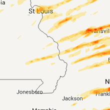
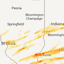
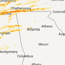
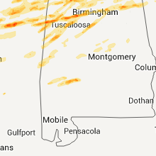
Hail Map for Friday, March 2, 2012

Number of Impacted Households on 3/2/2012
0
Impacted by 1" or Larger Hail
0
Impacted by 1.75" or Larger Hail
0
Impacted by 2.5" or Larger Hail
Square Miles of Populated Area Impacted on 3/2/2012
0
Impacted by 1" or Larger Hail
0
Impacted by 1.75" or Larger Hail
0
Impacted by 2.5" or Larger Hail


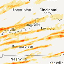

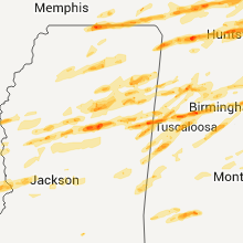
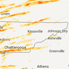

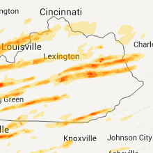


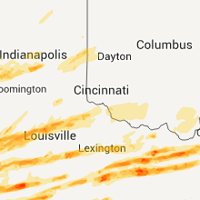


Cities Most Affected by Hail Storms of 3/2/2012
| Hail Size | Demographics of Zip Codes Affected | ||||||
|---|---|---|---|---|---|---|---|
| City | Count | Average | Largest | Pop Density | House Value | Income | Age |
| Nashville, TN | 8 | 1.78 | 2.00 | 1664 | $168k | $44.8k | 34.8 |
| Munfordville, KY | 4 | 2.25 | 2.75 | 44 | $64k | $25.9k | 39.2 |
| Lebanon, TN | 4 | 2.19 | 2.75 | 253 | $121k | $39.9k | 37.9 |
| Jellico, TN | 3 | 2.08 | 2.75 | 217 | $49k | $21.4k | 43.2 |
| Columbus, MS | 3 | 2.08 | 2.75 | 108 | $64k | $27.2k | 34.9 |
| Jasper, TN | 3 | 2.08 | 2.75 | 147 | $83k | $35.2k | 41.8 |
| Poseyville, IN | 3 | 2.00 | 2.50 | 32 | $71k | $40.2k | 43.8 |
| Campton, KY | 2 | 3.00 | 3.00 | 24 | $49k | $18.8k | 41.6 |
| Jeffersonville, KY | 2 | 2.75 | 2.75 | 91 | $68k | $28.6k | 38.2 |
| Franklin, NC | 3 | 1.83 | 2.00 | 103 | $96k | $31.1k | 46.7 |
| Paintsville, KY | 3 | 1.75 | 1.75 | 135 | $68k | $24.9k | 41.9 |
| Lawrenceburg, KY | 3 | 1.75 | 1.75 | 120 | $90k | $45.4k | 38.4 |
| Lake Village, AR | 3 | 1.75 | 1.75 | 15 | $81k | $28.2k | 44.0 |
| Frankfort, KY | 3 | 1.75 | 1.75 | 230 | $92k | $40.2k | 40.0 |
| Terre Haute, IN | 3 | 1.75 | 1.75 | 607 | $81k | $41.2k | 37.1 |
| Ramsey, IL | 3 | 1.75 | 1.75 | 18 | $49k | $29.7k | 40.6 |
| Stantonville, TN | 2 | 2.38 | 3.00 | 47 | $59k | $31.7k | 44.5 |
| Pekin, IN | 2 | 2.25 | 2.75 | 77 | $82k | $40.1k | 37.9 |
| Florence, AL | 1 | 4.25 | 4.25 | 1227 | $74k | $24.0k | 35.5 |
| Chattanooga, TN | 2 | 2.13 | 2.50 | 1087 | $62k | $23.3k | 35.3 |
| West Liberty, KY | 2 | 2.13 | 2.50 | 34 | $59k | $22.0k | 38.6 |
| Mount Washington, KY | 2 | 2.13 | 2.50 | 678 | $115k | $47.4k | 37.2 |
| Worthville, KY | 1 | 4.25 | 4.25 | 23 | $61k | $32.6k | 42.1 |
| Grays Knob, KY | 2 | 2.00 | 2.00 | 0 | $0k | $0.0k | 49.0 |
| Fredericksburg, IN | 2 | 2.00 | 2.00 | 57 | $85k | $28.8k | 38.9 |
| Vevay, IN | 2 | 1.88 | 2.00 | 52 | $78k | $35.5k | 40.3 |
| Thelma, KY | 2 | 1.88 | 2.00 | 245 | $74k | $20.7k | 27.3 |
| Lancaster, KY | 2 | 1.75 | 1.75 | 90 | $83k | $34.6k | 41.5 |
| Bessemer, AL | 2 | 1.75 | 1.75 | 1413 | $49k | $21.8k | 37.0 |
| Centralia, IL | 2 | 1.75 | 1.75 | 155 | $53k | $34.0k | 41.1 |
| Wartrace, TN | 2 | 1.75 | 1.75 | 40 | $77k | $40.2k | 41.8 |
| Hazel Green, AL | 2 | 1.75 | 1.75 | 220 | $89k | $40.5k | 38.1 |
| Coker, AL | 2 | 1.75 | 1.75 | 75 | $109k | $45.4k | 38.6 |
| Shepherdsville, KY | 2 | 1.75 | 1.75 | 235 | $115k | $44.9k | 38.4 |
| Trussville, AL | 2 | 1.75 | 1.75 | 428 | $151k | $60.7k | 40.1 |
| Edmonton, KY | 2 | 1.75 | 1.75 | 33 | $52k | $23.0k | 40.9 |
| Columbia, KY | 2 | 1.75 | 1.75 | 48 | $62k | $24.4k | 38.5 |
| Gravel Switch, KY | 2 | 1.75 | 1.75 | 24 | $54k | $29.2k | 39.9 |
| Frenchburg, KY | 2 | 1.75 | 1.75 | 24 | $49k | $22.5k | 39.8 |
| Fort Gay, WV | 2 | 1.75 | 1.75 | 36 | $58k | $26.1k | 40.7 |
| Topton, NC | 2 | 1.75 | 1.75 | 15 | $94k | $25.1k | 51.9 |
| Empire, AL | 2 | 1.75 | 1.75 | 97 | $57k | $26.4k | 39.2 |
| Shelbyville, TN | 2 | 1.75 | 1.75 | 152 | $78k | $35.7k | 35.4 |
| Richmond, IN | 2 | 1.75 | 1.75 | 391 | $79k | $32.8k | 40.2 |
| Houlka, MS | 1 | 3.00 | 3.00 | 30 | $46k | $27.5k | 38.5 |
| Decherd, TN | 1 | 2.75 | 2.75 | 72 | $70k | $29.7k | 40.7 |
| New Liberty, KY | 1 | 2.75 | 2.75 | 211 | $414k | $35.6k | 0.0 |
| Brandenburg, KY | 1 | 2.75 | 2.75 | 170 | $94k | $40.0k | 38.9 |
| Summertown, TN | 1 | 2.75 | 2.75 | 56 | $74k | $31.3k | 36.7 |
| Coalgood, KY | 1 | 2.75 | 2.75 | 27 | $75k | $28.6k | 40.5 |
| Sandy Hook, KY | 1 | 2.75 | 2.75 | 27 | $52k | $20.2k | 39.2 |
| Steens, MS | 1 | 2.75 | 2.75 | 87 | $74k | $36.7k | 38.9 |
| Winchester, KY | 1 | 2.75 | 2.75 | 152 | $94k | $39.8k | 39.7 |
| Warsaw, KY | 1 | 2.75 | 2.75 | 81 | $87k | $31.8k | 37.3 |
| Mount Eden, KY | 1 | 2.50 | 2.50 | 41 | $92k | $40.6k | 39.8 |
| Haubstadt, IN | 1 | 2.50 | 2.50 | 91 | $112k | $52.0k | 39.9 |
| Salyersville, KY | 1 | 2.50 | 2.50 | 32 | $57k | $20.1k | 39.1 |
| Spencer, TN | 1 | 2.00 | 2.00 | 26 | $54k | $27.2k | 42.9 |
| Mount Juliet, TN | 1 | 2.00 | 2.00 | 447 | $146k | $58.8k | 39.1 |
| Jonesville, KY | 1 | 2.00 | 2.00 | 124 | $79k | $42.5k | 41.9 |
| Blaine, KY | 1 | 2.00 | 2.00 | 19 | $30k | $17.5k | 39.4 |
| Aberdeen, MS | 1 | 2.00 | 2.00 | 49 | $60k | $28.3k | 38.4 |
| Birdseye, IN | 1 | 2.00 | 2.00 | 32 | $76k | $37.6k | 42.3 |
| Princeton, IN | 1 | 2.00 | 2.00 | 155 | $67k | $33.7k | 39.2 |
| Dora, AL | 1 | 2.00 | 2.00 | 188 | $83k | $32.3k | 40.3 |
| Richmond, KY | 1 | 2.00 | 2.00 | 202 | $99k | $32.4k | 32.5 |
| Sherwood, TN | 1 | 1.75 | 1.75 | 5 | $41k | $23.8k | 50.3 |
| Oneida, TN | 1 | 1.75 | 1.75 | 53 | $64k | $25.9k | 37.6 |
| English, IN | 1 | 1.75 | 1.75 | 24 | $60k | $29.3k | 42.2 |
| Waddy, KY | 1 | 1.75 | 1.75 | 49 | $81k | $47.9k | 42.8 |
| Cherokee, AL | 1 | 1.75 | 1.75 | 21 | $57k | $29.7k | 45.2 |
| Waco, KY | 1 | 1.75 | 1.75 | 65 | $69k | $27.5k | 41.3 |
| Saint Anthony, IN | 1 | 1.75 | 1.75 | 48 | $106k | $42.1k | 40.6 |
| Hermitage, TN | 1 | 1.75 | 1.75 | 1346 | $118k | $46.5k | 35.4 |
| Meridianville, AL | 1 | 1.75 | 1.75 | 444 | $115k | $59.6k | 39.5 |
| Oil Springs, KY | 1 | 1.75 | 1.75 | 49 | $47k | $30.8k | 39.3 |
| Middleton, TN | 1 | 1.75 | 1.75 | 31 | $67k | $31.9k | 41.7 |
| Leitchfield, KY | 1 | 1.75 | 1.75 | 86 | $68k | $27.9k | 38.5 |
| Taft, TN | 1 | 1.75 | 1.75 | 43 | $67k | $34.7k | 41.0 |
| Sharpsburg, KY | 1 | 1.75 | 1.75 | 26 | $56k | $23.7k | 41.7 |
| Breese, IL | 1 | 1.75 | 1.75 | 126 | $95k | $48.3k | 39.2 |
| Dickson, TN | 1 | 1.75 | 1.75 | 136 | $97k | $37.6k | 37.9 |
| Evansville, IN | 1 | 1.75 | 1.75 | 1952 | $76k | $38.3k | 39.6 |
| Mantee, MS | 1 | 1.75 | 1.75 | 17 | $49k | $30.4k | 40.3 |
| Bernice, LA | 1 | 1.75 | 1.75 | 21 | $57k | $26.1k | 38.6 |
| Cambridge City, IN | 1 | 1.75 | 1.75 | 78 | $79k | $34.8k | 40.8 |
| Hardinsburg, IN | 1 | 1.75 | 1.75 | 43 | $65k | $32.0k | 39.8 |
| Carrollton, KY | 1 | 1.75 | 1.75 | 170 | $84k | $35.5k | 37.0 |
| Hamlin, WV | 1 | 1.75 | 1.75 | 56 | $67k | $25.7k | 43.3 |
| Toney, AL | 1 | 1.75 | 1.75 | 178 | $85k | $38.9k | 35.5 |
| Campbellsville, KY | 1 | 1.75 | 1.75 | 99 | $71k | $28.8k | 39.3 |
| Glenville, NC | 1 | 1.75 | 1.75 | 14 | $248k | $37.0k | 50.2 |
| Clay, KY | 1 | 1.75 | 1.75 | 26 | $47k | $32.9k | 40.2 |
| Neoga, IL | 1 | 1.75 | 1.75 | 43 | $80k | $41.8k | 42.9 |
| Louisa, KY | 1 | 1.75 | 1.75 | 58 | $58k | $22.5k | 39.8 |
| Fort Branch, IN | 1 | 1.75 | 1.75 | 82 | $88k | $46.8k | 38.7 |
| Bainbridge, IN | 1 | 1.75 | 1.75 | 33 | $88k | $36.9k | 41.8 |
| Eckerty, IN | 1 | 1.75 | 1.75 | 28 | $64k | $41.3k | 45.2 |
| Science Hill, KY | 1 | 1.75 | 1.75 | 80 | $67k | $27.0k | 38.5 |
| New Harmony, IN | 1 | 1.75 | 1.75 | 19 | $82k | $36.3k | 48.6 |
| Baskin, LA | 1 | 1.75 | 1.75 | 18 | $47k | $26.8k | 39.5 |
| Harlan, KY | 1 | 1.75 | 1.75 | 89 | $57k | $18.8k | 41.3 |
| Wallins Creek, KY | 1 | 1.75 | 1.75 | 40 | $46k | $16.8k | 42.4 |
| Georgetown, KY | 1 | 1.75 | 1.75 | 272 | $110k | $48.3k | 34.2 |
| Rome, GA | 1 | 1.75 | 1.75 | 233 | $80k | $32.1k | 39.4 |
| Junction City, KY | 1 | 1.75 | 1.75 | 206 | $60k | $28.8k | 38.1 |
| Crawford, MS | 1 | 1.75 | 1.75 | 19 | $44k | $20.1k | 35.5 |
| Slaughters, KY | 1 | 1.75 | 1.75 | 23 | $60k | $45.9k | 40.4 |
| Fulton, MO | 1 | 1.75 | 1.75 | 88 | $82k | $36.9k | 35.1 |
| Means, KY | 1 | 1.75 | 1.75 | 61 | $62k | $20.3k | 37.9 |
| Berry, AL | 1 | 1.75 | 1.75 | 19 | $61k | $27.1k | 39.5 |
| Millport, AL | 1 | 1.75 | 1.75 | 16 | $59k | $29.4k | 44.9 |
| Denniston, KY | 1 | 1.75 | 1.75 | 41 | $74k | $25.3k | 33.7 |
| Paint Lick, KY | 1 | 1.75 | 1.75 | 51 | $81k | $36.6k | 37.7 |
| Birmingham, AL | 1 | 1.75 | 1.75 | 1886 | $162k | $67.6k | 39.1 |
| New Market, AL | 1 | 1.75 | 1.75 | 100 | $85k | $36.5k | 36.3 |
| Eubank, KY | 1 | 1.75 | 1.75 | 61 | $60k | $25.4k | 40.4 |
| Taylorsville, KY | 1 | 1.75 | 1.75 | 114 | $124k | $49.9k | 39.2 |
| Bethalto, IL | 1 | 1.75 | 1.75 | 508 | $82k | $45.2k | 40.4 |
| Acworth, GA | 1 | 1.75 | 1.75 | 1380 | $145k | $66.8k | 36.1 |
| Madisonville, KY | 1 | 1.75 | 1.75 | 161 | $63k | $32.1k | 40.2 |
| Ethridge, TN | 1 | 1.75 | 1.75 | 66 | $66k | $27.3k | 31.2 |
| Hanover, IN | 1 | 1.75 | 1.75 | 142 | $79k | $40.2k | 32.5 |
| Cadiz, KY | 1 | 1.75 | 1.75 | 45 | $75k | $32.5k | 44.5 |
| Grand Junction, TN | 1 | 1.75 | 1.75 | 23 | $56k | $27.6k | 37.2 |
| Wilsondale, WV | 1 | 1.75 | 1.75 | 13 | $45k | $21.4k | 38.4 |
| Indianapolis, IN | 1 | 1.75 | 1.75 | 2909 | $78k | $23.0k | 30.4 |
| Ardmore, AL | 1 | 1.75 | 1.75 | 203 | $80k | $36.6k | 38.1 |
| Rockville, IN | 1 | 1.75 | 1.75 | 45 | $79k | $36.0k | 41.5 |
| Oakman, AL | 1 | 1.75 | 1.75 | 21 | $62k | $27.0k | 42.0 |
| Schnellville, IN | 1 | 1.75 | 1.75 | 59 | $76k | $36.3k | 32.8 |
| Rogersville, AL | 1 | 1.75 | 1.75 | 98 | $87k | $35.2k | 43.4 |
| Fayetteville, TN | 1 | 1.75 | 1.75 | 89 | $75k | $33.7k | 42.2 |
| Kell, IL | 1 | 1.75 | 1.75 | 35 | $62k | $42.2k | 43.0 |
| New Burnside, IL | 1 | 1.75 | 1.75 | 26 | $31k | $30.3k | 40.7 |
| Westfield, IL | 1 | 1.75 | 1.75 | 16 | $50k | $35.0k | 42.1 |
| French Camp, MS | 1 | 1.75 | 1.75 | 15 | $57k | $25.4k | 37.9 |
| Caneyville, KY | 1 | 1.75 | 1.75 | 25 | $58k | $25.1k | 39.9 |
| Burns, TN | 1 | 1.75 | 1.75 | 109 | $122k | $49.2k | 40.2 |
| Corydon, KY | 1 | 1.75 | 1.75 | 25 | $69k | $38.3k | 41.1 |
| Farmerville, LA | 1 | 1.75 | 1.75 | 53 | $70k | $30.1k | 39.8 |
| Russell Springs, KY | 1 | 1.75 | 1.75 | 77 | $61k | $21.8k | 40.7 |
| Oak Grove, LA | 1 | 1.75 | 1.75 | 32 | $49k | $25.5k | 40.1 |
| Salem, KY | 1 | 1.75 | 1.75 | 20 | $49k | $29.5k | 47.3 |
| Starkville, MS | 1 | 1.75 | 1.75 | 135 | $93k | $25.2k | 25.8 |
| Dubach, LA | 1 | 1.75 | 1.75 | 25 | $70k | $33.7k | 41.7 |
| Lynnville, TN | 1 | 1.75 | 1.75 | 29 | $68k | $40.2k | 43.2 |
| Florissant, MO | 1 | 1.75 | 1.75 | 3235 | $78k | $49.5k | 38.0 |
| Brazil, IN | 1 | 1.75 | 1.75 | 130 | $73k | $36.9k | 39.9 |
Hail and Wind Damage Spotted on 3/2/2012
Filter by Report Type:Hail ReportsWind Reports
States Impacted
Missouri, Illinois, Indiana, Alabama, Virginia, North Carolina, Tennessee, South Carolina, Kentucky, Mississippi, Louisiana, Arkansas, Ohio, Texas, West Virginia, GeorgiaMissouri
| Local Time | Report Details |
|---|---|
| 6:04 AM CST | Quarter sized hail reported near Florissant, MO, 13.6 miles NNW of Saint Louis, MO |
| 6:09 AM CST | Golf Ball sized hail reported near Florissant, MO, 14.2 miles NNW of Saint Louis, MO |
| 6:14 AM CST | Quarter sized hail reported near Fulton, MO, 21.9 miles ESE of Columbia, MO |
| 6:16 AM CST | Golf Ball sized hail reported near Fulton, MO, 21.9 miles ESE of Columbia, MO |
| 6:43 AM CST | Quarter sized hail reported near Montgomery City, MO, 44.4 miles E of Columbia, MO |
| 6:51 AM CST | Half Dollar sized hail reported near St Peters, MO, 22.2 miles WNW of Saint Louis, MO |
| 12:06 PM CST | Quarter sized hail reported near Cape Girardeau, MO, 0.6 miles NNW of Cape Girardeau, MO, quarter size hail reported near wallmart along highway h. |
| 6:22 PM UTC | 3 inch diamter branches falling with shingles ripped off on one roof in the community of scott cit in cape girardeau county MO, 1.6 miles S of Cape Girardeau, MO |
| 6:35 PM UTC | Late report...shingles blown off of roof of home. wind gusts estimated 60 to 70 mp in stoddard county MO, 49.6 miles SSW of Cape Girardeau, MO |
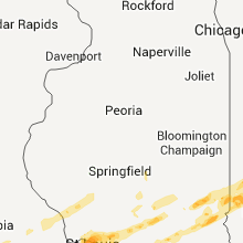
Illinois
| Local Time | Report Details |
|---|---|
| 6:19 AM CST | Quarter sized hail reported near Alton, IL, 19 miles N of Saint Louis, MO |
| 12:20 PM UTC | Quarter sized hail reported near Godfrey, IL, 23.6 miles N of Saint Louis, MO |
| 12:22 PM UTC | Quarter sized hail reported near Godfrey, IL, 23.6 miles N of Saint Louis, MO |
| 6:22 AM CST | Quarter sized hail reported near Wood River, IL, 17.3 miles NNE of Saint Louis, MO |
| 6:24 AM CST | Golf Ball sized hail reported near Bethalto, IL, 20.4 miles NNE of Saint Louis, MO |
| 6:25 AM CST | Quarter sized hail reported near Edwardsville, IL, 17.2 miles NE of Saint Louis, MO |
| 6:29 AM CST | Half Dollar sized hail reported near Alton, IL, 19 miles N of Saint Louis, MO |
| 12:46 PM UTC | Quarter sized hail reported near New Douglas, IL, 37.1 miles NE of Saint Louis, MO |
| 7:03 AM CST | Quarter sized hail reported near Coffeen, IL, 54.1 miles NE of Saint Louis, MO |
| 1:10 PM UTC | Quarter sized hail reported near Nokomis, IL, 50.5 miles WSW of Mattoon, IL |
| 1:22 PM UTC | Quarter sized hail reported near Ramsey, IL, 46.9 miles WSW of Mattoon, IL |
| 1:25 PM UTC | Quarter sized hail reported near Ramsey, IL, 45.9 miles WSW of Mattoon, IL |
| 1:32 PM UTC | Golf Ball sized hail reported near Ramsey, IL, 45.9 miles WSW of Mattoon, IL |
| 1:44 PM UTC | Golf Ball sized hail reported near Ramsey, IL, 38.6 miles WSW of Mattoon, IL |
| 7:44 AM CST | Golf Ball sized hail reported near Ramsey, IL, 38.9 miles WSW of Mattoon, IL |
| 1:45 PM UTC | Half Dollar sized hail reported near Beecher City, IL, 26.6 miles WSW of Mattoon, IL, delayed report |
| 8:02 AM CST | Ping Pong Ball sized hail reported near Neoga, IL, 11.8 miles SSW of Mattoon, IL |
| 2:02 PM UTC | Golf Ball sized hail reported near Neoga, IL, 10.2 miles SSW of Mattoon, IL, swop |
| 8:29 AM CST | Golf Ball sized hail reported near Westfield, IL, 20.1 miles E of Mattoon, IL |
| 8:46 AM CST | Quarter sized hail reported near Paris, IL, 37.9 miles ENE of Mattoon, IL, swop report. |
| 10:00 AM CST | 8 50 foot pine trees snapped half way up along rentchler road in st. clair county IL, 18.6 miles SE of Saint Louis, MO |
| 4:20 PM UTC | Half Dollar sized hail reported near Aviston, IL, 31.9 miles E of Saint Louis, MO |
| 10:21 AM CST | Golf Ball sized hail reported near Breese, IL, 36.8 miles E of Saint Louis, MO |
| 4:33 PM UTC | Minor shingle damage in st. clair county IL, 14.5 miles ESE of Saint Louis, MO |
| 11:13 AM CST | Quarter sized hail reported near Farina, IL, 49.9 miles SSW of Mattoon, IL |
| 11:25 AM CST | Quarter sized hail reported near Christopher, IL, 53.4 miles NNE of Cape Girardeau, MO, quarter size hail reported in the community. |
| 11:40 AM CST | Quarter sized hail reported near Nashville, IL, 46.8 miles ESE of Saint Louis, MO |
| 11:41 AM CST | Quarter sized hail reported near West Frankfort, IL, 53.2 miles NE of Cape Girardeau, MO, quarter size hail reported with near zero visibility. |
| 11:47 AM CST | Quarter sized hail reported near Hoyleton, IL, 51.8 miles ESE of Saint Louis, MO |
| 11:49 AM CST | Quarter sized hail reported near Nashville, IL, 48.4 miles ESE of Saint Louis, MO |
| 11:50 AM CST | Golf Ball sized hail reported near Centralia, IL, 58.4 miles E of Saint Louis, MO |
| 11:54 AM CST | Quarter sized hail reported near Centralia, IL, 58.4 miles E of Saint Louis, MO |
| 11:58 AM CST | Golf Ball sized hail reported near Centralia, IL, 65.5 miles E of Saint Louis, MO |
| 12:00 PM CST | Quarter sized hail reported near McLeansboro, IL, 53.3 miles W of Evansville, IN |
| 12:00 PM CST | Quarter sized hail reported near Centralia, IL, 68.3 miles E of Saint Louis, MO |
| 6:02 PM UTC | Golf Ball sized hail reported near Kell, IL, 68.6 miles E of Saint Louis, MO, reported at i57 and route 161...relayed from wfo ilx |
| 12:24 PM CST | Power lines down in white county IL, 34 miles WNW of Evansville, IN |
| 12:27 PM CST | Dime size hail reported with this stor in jackson county IL, 35.7 miles NE of Cape Girardeau, MO |
| 12:31 PM CST | Large amount of power lines down throughout the communit in white county IL, 34 miles WNW of Evansville, IN |
| 12:32 PM CST | Half Dollar sized hail reported near Grayville, IL, 30.7 miles NW of Evansville, IN, estimated 45 mph winds |
| 12:55 PM CST | Golf Ball sized hail reported near New Burnside, IL, 46.7 miles ENE of Cape Girardeau, MO, golf ball size hail reported. |
| 7:16 PM UTC | Storm damage reported in massac county IL, 45.3 miles E of Cape Girardeau, MO |
| 8:25 PM UTC | Half Dollar sized hail reported near Noble, IL, 51.7 miles SSE of Mattoon, IL, at beach grove |
Indiana
| Local Time | Report Details |
|---|---|
| 9:50 AM EST | Golf Ball sized hail reported near Terre Haute, IN, 53.2 miles E of Mattoon, IL, at 13th and delaware streets in terre haute. |
| 9:51 AM EST | Golf Ball sized hail reported near Terre Haute, IN, 53.2 miles E of Mattoon, IL, 13th and wabash streets in terre haute. |
| 9:52 AM EST | Golf Ball sized hail reported near Terre Haute, IN, 53.2 miles E of Mattoon, IL |
| 10:07 AM EST | Quarter sized hail reported near Brazil, IN, 54.5 miles WSW of Indianapolis, IN |
| 10:07 AM EST | Golf Ball sized hail reported near Brazil, IN, 54.5 miles WSW of Indianapolis, IN |
| 10:07 AM EST | Golf Ball sized hail reported near Rockville, IN, 57.5 miles W of Indianapolis, IN |
| 10:21 AM EST | Quarter sized hail reported near Greencastle, IN, 36.3 miles WSW of Indianapolis, IN |
| 10:31 AM EST | Ping Pong Ball sized hail reported near Bainbridge, IN, 36.8 miles W of Indianapolis, IN |
| 10:34 AM EST | Golf Ball sized hail reported near Bainbridge, IN, 35.7 miles W of Indianapolis, IN |
| 10:44 AM EST | Quarter sized hail reported near Plainfield, IN, 13.6 miles WSW of Indianapolis, IN |
| 10:51 AM EST | Quarter sized hail reported near North Salem, IN, 26.9 miles WNW of Indianapolis, IN |
| 10:56 AM EST | Half Dollar sized hail reported near Indianapolis, IN, 0.5 miles S of Indianapolis, IN |
| 10:58 AM EST | Half Dollar sized hail reported near Indianapolis, IN, 0.9 miles N of Indianapolis, IN |
| 10:58 AM EST | Golf Ball sized hail reported near Indianapolis, IN, 0.9 miles N of Indianapolis, IN, hail measured at i-465 and harding |
| 11:07 AM EST | Quarter sized hail reported near Indianapolis, IN, 0.9 miles N of Indianapolis, IN, emerson avenue and southeastern avenue |
| 11:10 AM EST | Half Dollar sized hail reported near Indianapolis, IN, 0.9 miles N of Indianapolis, IN, hail measured at the university of indianapolis |
| 11:30 AM EST | Ping Pong Ball sized hail reported near Indianapolis, IN, 6.7 miles WSW of Indianapolis, IN |
| 12:36 PM CST | Golf Ball sized hail reported near New Harmony, IN, 22.6 miles WNW of Evansville, IN, golf ball hail reported by trained spotter. |
| 12:38 PM CST | Golf Ball sized hail reported near Poseyville, IN, 16.3 miles NW of Evansville, IN, on highway 165. also a funnel cloud was reported. |
| 12:43 PM CST | Quarter sized hail reported near Poseyville, IN, 18.3 miles NW of Evansville, IN, quarter size hail reported just north of town. |
| 12:45 PM CST | Late report time estimated...large hail damaged several homes and a few vehicle in gibson county IN, 18.8 miles N of Evansville, IN |
| 12:46 PM CST | 2 story home lost the roo in posey county IN, 13.9 miles WNW of Evansville, IN |
| 12:46 PM CST | Tennis Ball sized hail reported near Poseyville, IN, 15.8 miles NW of Evansville, IN, tennis ball hail reported just north of wadesville. |
| 12:47 PM CST | Golf Ball sized hail reported near Poseyville, IN, 16.3 miles NW of Evansville, IN, golf ball size hail reported just south of town. |
| 12:47 PM CST | Late report...sheriff reporting significant residential structure damage throughout central posy count in posey county IN, 17.8 miles NW of Evansville, IN |
| 12:48 PM CST | Quarter sized hail reported near Fort Branch, IN, 18.8 miles N of Evansville, IN, quarter size hail reported. |
| 12:50 PM CST | Golf Ball sized hail reported near Evansville, IN, 2.6 miles NNE of Evansville, IN |
| 12:51 PM CST | Half Dollar sized hail reported near Haubstadt, IN, 15.4 miles N of Evansville, IN, half dollar size hail reported. |
| 1:52 PM EST | Quarter sized hail reported near Brazil, IN, 54.5 miles WSW of Indianapolis, IN |
| 12:53 PM CST | Hen Egg sized hail reported near Princeton, IN, 26.4 miles N of Evansville, IN |
| 12:55 PM CST | Golf Ball sized hail reported near Fort Branch, IN, 18.8 miles N of Evansville, IN, golf ball size hail reported in the community of fort branch. |
| 12:57 PM CST | Tennis Ball sized hail reported near Haubstadt, IN, 16.8 miles N of Evansville, IN, tennis ball size hail reported south of fort branch. |
| 2:00 PM EST | Quarter sized hail reported near Greencastle, IN, 37.8 miles WSW of Indianapolis, IN |
| 1:04 PM CST | News media is reported significant storm damage across the northern half of vanderburgh count in vanderburgh county IN, 1.3 miles E of Evansville, IN |
| 2:07 PM EST | Ping Pong Ball sized hail reported near Bainbridge, IN, 31.5 miles W of Indianapolis, IN |
| 2:08 PM EST | Quarter sized hail reported near Huntingburg, IN, 39.7 miles NE of Evansville, IN |
| 2:14 PM EST | Quarter sized hail reported near Stendal, IN, 32 miles NE of Evansville, IN |
| 2:15 PM EST | Quarter sized hail reported near Birdseye, IN, 52.4 miles ENE of Evansville, IN |
| 2:23 PM EST | Quarter sized hail reported near Jasper, IN, 43.3 miles NE of Evansville, IN |
| 2:23 PM EST | Hen Egg sized hail reported near Birdseye, IN, 52.4 miles ENE of Evansville, IN, two inch hail covering the ground |
| 2:27 PM EST | Golf Ball sized hail reported near Eckerty, IN, 52.1 miles WNW of Louisville, KY |
| 2:32 PM EST | Quarter sized hail reported near Plainfield, IN, 13.6 miles WSW of Indianapolis, IN |
| 2:36 PM EST | Quarter sized hail reported near Mooresville, IN, 15.5 miles SW of Indianapolis, IN |
| 2:36 PM EST | Golf Ball sized hail reported near English, IN, 46.9 miles WNW of Louisville, KY |
| 2:40 PM EST | Quarter sized hail reported near Camby, IN, 11.3 miles SW of Indianapolis, IN |
| 2:40 PM EST | Golf Ball sized hail reported near St Anthony, IN, 46.5 miles ENE of Evansville, IN |
| 2:43 PM EST | Golf Ball sized hail reported near Schnellville, IN, 50.9 miles ENE of Evansville, IN |
| 2:44 PM EST | Storm damage reported in lawrence county IN, 65.2 miles SSW of Indianapolis, IN |
| 2:52 PM EST | Golf Ball sized hail reported near Hardinsburg, IN, 48.1 miles NW of Louisville, KY |
| 2:55 PM EST | Quarter sized hail reported near Noblesville, IN, 21.2 miles NNE of Indianapolis, IN |
| 3:02 PM EST | Damage reported acorss the area in washington county IN, 39 miles NNW of Louisville, KY |
| 3:03 PM EST | At east washington elementary school in washington county IN, 39 miles NNW of Louisville, KY |
| 3:04 PM EST | 53 foot semi tractor trailer blown over on eastbound interstate 74 just west of mile marker 12 in decatur county IN, 37.6 miles SE of Indianapolis, IN |
| 3:20 PM EST | Hen Egg sized hail reported near Fredericksburg, IN, 39.9 miles NW of Louisville, KY |
| 3:23 PM EST | Baseball sized hail reported near Pekin, IN, 39 miles NNW of Louisville, KY |
| 2:24 PM CST | Quarter sized hail reported near Rockport, IN, 28.9 miles ESE of Evansville, IN |
| 8:26 PM UTC | Downed trees and power lines reported in the communit in spencer county IN, 28.9 miles ESE of Evansville, IN |
| 3:28 PM EST | Golf Ball sized hail reported near Pekin, IN, 39 miles NNW of Louisville, KY |
| 2:30 PM CST | Downed trees blocking several streets within the communit in spencer county IN, 36 miles ENE of Evansville, IN |
| 3:32 PM EST | Hen Egg sized hail reported near Fredericksburg, IN, 39.9 miles NW of Louisville, KY |
| 3:36 PM EST | Golf Ball sized hail reported near Hanover, IN, 52.9 miles NNE of Louisville, KY |
| 3:39 PM EST | Gust measured by ham operator. resulted in broken anemomete in henry county IN, 44.4 miles E of Indianapolis, IN |
| 3:40 PM EST | Quarter sized hail reported near Straughn, IN, 46.9 miles E of Indianapolis, IN |
| 3:42 PM EST | Quarter sized hail reported near Leavenworth, IN, 40.1 miles WNW of Louisville, KY, 60 mph winds |
| 3:42 PM EST | Golf Ball sized hail reported near Richmond, IN, 54 miles NNW of Cincinnati, OH |
| 3:42 PM EST | Tree down at sr 3 and 500 n. right after this report was a report of a tornado on the ground east of butlerville but still in jennings county. no damage could be confir in jennings county IN, 54.3 miles W of Cincinnati, OH |
| 8:43 PM UTC | Highway 61 north blocked by downed tre in warrick county IN, 17.3 miles ENE of Evansville, IN |
| 3:45 PM EST | Damage reported in clark county IN, 41 miles N of Louisville, KY |
| 3:49 PM EST | Golf Ball sized hail reported near Cambridge City, IN, 52.2 miles E of Indianapolis, IN |
| 3:49 PM EST | Hen Egg sized hail reported near Vevay, IN, 38.7 miles SW of Cincinnati, OH |
| 3:57 PM EST | Golf Ball sized hail reported near Richmond, IN, 54 miles NNW of Cincinnati, OH |
| 8:58 PM UTC | Quarter sized hail reported near Greenville, IN, 30 miles NNW of Louisville, KY, pekin road and highway 150. |
| 3:58 PM EST | Golf Ball sized hail reported near Vevay, IN, 38.7 miles SW of Cincinnati, OH |
| 4:09 PM EST | Quarter sized hail reported near Sellersburg, IN, 27.8 miles N of Louisville, KY |
| 4:15 PM EST | Storm damage reported in clark county IN, 32 miles N of Louisville, KY |
| 9:25 PM UTC | 3/4 of roof off of hous in ripley county IN, 42.2 miles W of Cincinnati, OH |
| 4:44 PM EST | Quarter sized hail reported near Nabb, IN, 43.2 miles N of Louisville, KY |
| 4:45 PM EST | Storm damage reported in jefferson county IN, 43.8 miles N of Louisville, KY |
Alabama
| Local Time | Report Details |
|---|---|
| 9:20 AM CST | Wind picking up debris with estimated wind gust of 50mph. rotation seen in storm. no injurie in limestone county AL, 44.7 miles E of Florence, AL |
| 9:20 AM CST | Power lines and trees down and structural damage seen at craft road and mooresville roa in limestone county AL, 45.2 miles E of Florence, AL |
| 9:58 AM CST | Golf Ball sized hail reported near Ardmore, AL, 48.7 miles ENE of Florence, AL |
| 10:05 AM CST | Golf Ball sized hail reported near Meridianville, AL, 62.9 miles E of Florence, AL |
| 2:00 PM CST | Quarter sized hail reported near Elkmont, AL, 45.9 miles ENE of Florence, AL, quarter sized hail and possible wall cloud reported near i-65 welcome center. |
| 2:07 PM CST | Quarter sized hail reported near Cherokee, AL, 25.9 miles WSW of Florence, AL, quarter and nickel sized hail reported |
| 2:15 PM CST | Baseball sized hail reported near Cherokee, AL, 12.9 miles WSW of Florence, AL, baseball sized hail reported in barton |
| 2:18 PM CST | Golf Ball sized hail reported near Cherokee, AL, 17 miles W of Florence, AL, golfball size hail was reported. |
| 2:30 PM CST | Quarter sized hail reported near Cherokee, AL, 12.9 miles WSW of Florence, AL, quarater size hail was reported. |
| 2:30 PM CST | Quarter sized hail reported near Cherokee, AL, 12.9 miles WSW of Florence, AL, quarter size hail was reported. |
| 2:35 PM CST | Quarter sized hail reported near Florence, AL, 2.1 miles N of Florence, AL, quarter size hail was reported. |
| 2:35 PM CST | Half Dollar sized hail reported near Florence, AL, 1.6 miles NNW of Florence, AL, half dollar sized hail reported in florence |
| 2:35 PM CST | Grapefruit sized hail reported near Florence, AL, 2.1 miles N of Florence, AL, softball size hail was reported. |
| 8:35 PM UTC | Small tree limbs down north of florence in lauderdale county AL, 4.8 miles N of Florence, AL |
| 2:45 PM CST | Quarter sized hail reported near Florence, AL, 2.6 miles WNW of Florence, AL, dime to quarter size hail was reported covering the ground. |
| 2:46 PM CST | Roof was blown off of a building at 2nd street and woodward. possible tornado damag in colbert county AL, 2.8 miles S of Florence, AL |
| 3:00 PM CST | Golf Ball sized hail reported near Rogersville, AL, 17.1 miles ENE of Florence, AL, quarter size hail was reported. |
| 3:05 PM CST | Quarter sized hail reported near Florence, AL, 2.1 miles N of Florence, AL, 2 inches of hail up to the size of quarters was reported. |
| 9:15 PM UTC | Several trees and powerlines were blown dow in pickens county AL, 34.3 miles E of Starkville, MS |
| 9:21 PM UTC | Trees were blown down on a house in white pike area. fire and ems enroute to location. injuries unknow in colbert county AL, 19.5 miles WSW of Florence, AL |
| 9:45 PM UTC | Half Dollar sized hail reported near Hazel Green, AL, 62.5 miles ENE of Florence, AL, half dollar sized hail falling 4 miles nnw of hazel green |
| 3:48 PM CST | Golf Ball sized hail reported near Toney, AL, 53.3 miles E of Florence, AL, golf ball sized hail reported at ready section rd and wall triana hwy |
| 9:49 PM UTC | Trees down and structural damage to roof 3 miles north of rogersvill in lauderdale county AL, 22.4 miles ENE of Florence, AL |
| 3:52 PM CST | Tree damage was reporte in limestone county AL, 49.1 miles E of Florence, AL |
| 9:55 PM UTC | Quarter sized hail reported near Double Springs, AL, 47.5 miles SSE of Florence, AL |
| 3:58 PM CST | Quarter sized hail reported near Berry, AL, 49 miles W of Birmingham, AL, hail of just over one inch reported just south of new lexington. |
| 3:59 PM CST | Golf Ball sized hail reported near Hazel Green, AL, 63.4 miles E of Florence, AL, golfball size hail was reported. |
| 4:00 PM CST | Golf Ball sized hail reported near Hazel Green, AL, 63.4 miles E of Florence, AL, golfball size hail reported. |
| 4:03 PM CST | Half Dollar sized hail reported near New Market, AL, 66.3 miles E of Florence, AL, quarter to half dollar sized hail reported at joe quick rd and tanner rd |
| 4:05 PM CST | Quarter sized hail reported near New Market, AL, 66.9 miles W of Chattanooga, TN, quarter sized hail reported at butler rd and new market rd |
| 4:06 PM CST | Golf Ball sized hail reported near New Market, AL, 64.3 miles W of Chattanooga, TN, golfball size hail reported. |
| 4:09 PM CST | Quarter sized hail reported near Hazel Green, AL, 60.9 miles E of Florence, AL, measured in the 1500 block of elkwood section road. |
| 4:18 PM CST | Quarter sized hail reported near Decatur, AL, 44.1 miles ESE of Florence, AL, quarter sized hail reported near austinville rd. |
| 4:22 PM CST | Golf Ball sized hail reported near Oakman, AL, 32.4 miles W of Birmingham, AL, large hail up to the size of golf balls were observed along highway 69 along the walker...tuscaloosa county line. |
| 10:31 PM UTC | Sr 269 and 24th st - trees down in walker county AL, 34.8 miles NW of Birmingham, AL |
| 10:31 PM UTC | Trees were blown down at sr 269 and 24th s in walker county AL, 34.8 miles NW of Birmingham, AL |
| 4:31 PM CST | Quarter sized hail reported near Jasper, AL, 34.8 miles NW of Birmingham, AL, 1302 8th ave. |
| 4:31 PM CST | Quarter sized hail reported near Jasper, AL, 34.8 miles NW of Birmingham, AL, quarter size hail at 1302 8th ave in jasper. |
| 10:34 PM UTC | Quarter sized hail reported near Haleyville, AL, 41.5 miles S of Florence, AL |
| 10:37 PM UTC | Quarter sized hail reported near Jasper, AL, 26.2 miles NW of Birmingham, AL |
| 10:37 PM UTC | Quarter sized hail reported near Jasper, AL, 26.2 miles NW of Birmingham, AL, quarter size hail near sipsey. |
| 4:39 PM CST | Quarter sized hail reported near Thomasville, AL, 46.8 miles W of Camden, AL, clarke county emergency manager reported quarter size hail in cunningham. |
| 4:40 PM CST | Ping Pong Ball sized hail reported near Pine Hill, AL, 10.7 miles W of Camden, AL |
| 4:45 PM CST | Quarter sized hail reported near Huntsville, AL, 61.9 miles E of Florence, AL, dime to quarter size hail was reported. |
| 4:45 PM CST | Golf Ball sized hail reported near Empire, AL, 23 miles NNW of Birmingham, AL, golf ball size hail reported near the walker,blount and jefferson county line. |
| 4:45 PM CST | Golf Ball sized hail reported near Empire, AL, 23 miles NNW of Birmingham, AL, reported near the intersection of walker...blount...and jefferson counties. |
| 10:49 PM UTC | Quarter sized hail reported near Huntsville, AL, 64.9 miles E of Florence, AL, depth upto an inch of quarter sized hail reported |
| 10:50 PM UTC | Quarter sized hail reported near Dora, AL, 21.2 miles NW of Birmingham, AL |
| 10:50 PM UTC | Quarter sized hail reported near Dora, AL, 21.2 miles NW of Birmingham, AL, quarter size hail was observed in dora. |
| 10:58 PM UTC | Quarter sized hail reported near Warrior, AL, 25.5 miles N of Birmingham, AL, quarter size hail was reported on bryant mountain. |
| 10:58 PM UTC | Quarter sized hail reported near Warrior, AL, 25.5 miles N of Birmingham, AL, reported on bryant mountain. |
| 11:12 PM UTC | Quarter sized hail reported near Scottsboro, AL, 55.6 miles WSW of Chattanooga, TN, up to quarter size hail was reported. |
| 11:36 PM UTC | Roof off building on highway 26 in coffee county AL, 75.1 miles NNE of Miramar Beach, FL |
| 5:39 PM CST | Quarter sized hail reported near Springville, AL, 25.7 miles NE of Birmingham, AL, fire dept reported quarter size hail in springville. |
| 5:39 PM CST | Quarter sized hail reported near Springville, AL, 25.7 miles NE of Birmingham, AL, fire dept reporting quarter size hail in springville. |
| 5:49 PM CST | Quarter sized hail reported near Stevenson, AL, 32.5 miles WSW of Chattanooga, TN, quarter size hail was reported. |
| 11:52 PM UTC | Quarter sized hail reported near Scottsboro, AL, 48.8 miles WSW of Chattanooga, TN, dime to quarter size hail was reported. |
| 12:06 AM UTC | Significant tree damage along state road 21 near the beechwood community. possible tornad in lowndes county AL, 38.2 miles ENE of Camden, AL |
| 12:06 AM UTC | Significant tree damage was reported along state road 21 near the beechwood community. possible tornad in lowndes county AL, 38.2 miles ENE of Camden, AL |
| 12:15 AM UTC | Trees snapped and uprooted in detroit. people trapped in a storm shelte in lamar county AL, 53.7 miles NE of Starkville, MS |
| 12:15 AM UTC | Trees snapped and uprooted. people trapped in storm shelte in lamar county AL, 53.7 miles NE of Starkville, MS |
| 12:23 AM UTC | Trees down on a residence near the intersection of cr 35 and georgia circl in marion county AL, 51.7 miles SSW of Florence, AL |
| 6:25 PM CST | Quarter sized hail reported near Wellington, AL, 57 miles ENE of Birmingham, AL, quarter size hail was reported in wellington. |
| 6:25 PM CST | Quarter sized hail reported near Wellington, AL, 57 miles ENE of Birmingham, AL, reported in wellington. |
| 6:27 PM CST | Quarter sized hail reported near Blountsville, AL, 42.1 miles NNE of Birmingham, AL |
| 6:27 PM CST | Quarter sized hail reported near Blountsville, AL, 42.1 miles NNE of Birmingham, AL, quarter size hail was observed in blountsville. |
| 6:30 PM CST | Quarter sized hail reported near Jacksonville, AL, 63.8 miles ENE of Birmingham, AL |
| 6:30 PM CST | Quarter sized hail reported near Jacksonville, AL, 63.8 miles ENE of Birmingham, AL, quarter size hail was observed in jacksonville. |
| 12:30 AM UTC | Half Dollar sized hail reported near Stevenson, AL, 29.1 miles WSW of Chattanooga, TN |
| 12:30 AM UTC | Roof and sign damage to several businesses along south milita in marion county AL, 48.7 miles SSW of Florence, AL |
| 12:39 AM UTC | Half Dollar sized hail reported near Blountsville, AL, 44.7 miles NNE of Birmingham, AL |
| 12:39 AM UTC | Half Dollar sized hail reported near Blountsville, AL, 44.7 miles NNE of Birmingham, AL, half dollar size hail fell in susan moore. |
| 12:44 AM UTC | Quarter sized hail reported near Woodstock, AL, 28.2 miles SW of Birmingham, AL |
| 6:45 PM CST | Quarter sized hail reported near Jasper, AL, 34.8 miles NW of Birmingham, AL, hail up to one inch in downtown jasper. |
| 12:45 AM UTC | Half Dollar sized hail reported near Jasper, AL, 32.1 miles NW of Birmingham, AL, large hail was observed east northeast of jasper. |
| 12:46 AM UTC | Trees down on eastern valley rd near the tuscaloosa county line. power outages also reported in the same are in bibb county AL, 27.7 miles SW of Birmingham, AL |
| 12:48 AM UTC | Golf Ball sized hail reported near McCalla, AL, 23.9 miles SW of Birmingham, AL |
| 12:48 AM UTC | Golf Ball sized hail reported near McCalla, AL, 23.9 miles SW of Birmingham, AL, golf ball size hail was observed at the tannehill ironworks state park. |
| 12:49 AM UTC | Quarter sized hail reported near Boaz, AL, 51.2 miles NNE of Birmingham, AL, quarter size hail was reported. |
| 12:50 AM UTC | Quarter sized hail reported near Double Springs, AL, 49.2 miles SSE of Florence, AL |
| 12:50 AM UTC | Quarter sized hail reported near Double Springs, AL, 49.2 miles SSE of Florence, AL, quarter size hail fell near double springs. |
| 12:52 AM UTC | Quarter sized hail reported near Bessemer, AL, 16.4 miles SW of Birmingham, AL |
| 12:52 AM UTC | Quarter sized hail reported near Bessemer, AL, 16.4 miles SW of Birmingham, AL, quarter size hail fell near mccalla. |
| 12:55 AM UTC | Quarter sized hail reported near Double Springs, AL, 47.5 miles SSE of Florence, AL, correction |
| 12:55 AM UTC | Quarter sized hail reported near Double Springs, AL, 47.5 miles SSE of Florence, AL, quarter size hail fell near double springs. |
| 6:55 PM CST | National weather service meteorologists surveyed eastern cleburne county. damage was consistent with strong inflow winds on the south side of the storm. maximum winds w in cleburne county AL, 59.9 miles W of Atlanta, GA |
| 12:55 AM UTC | A tin roof blown off of a shed near the intersection of cr 10 and hwy 11. metal awning blown off of a mobile home near the intersection of hwy 11 and sheepskin rd. roof in sumter county AL, 70.3 miles WNW of Camden, AL |
| 12:55 AM UTC | Tin roof blown off of shed near the intersection of cr 10 and hwy 11. metal awning blown off of mobile home near the intersection of hwy 11 and sheepskin rd. roof compl in sumter county AL, 70.3 miles WNW of Camden, AL |
| 12:55 AM UTC | A tin roof blown off of a shed near the intersection of cr 10 and hwy 11. metal awning blown off of a mobile home near the intersection of hwy 11 and sheepskin rd. roof in sumter county AL, 70.3 miles WNW of Camden, AL |
| 6:55 PM CST | Possible tornado - piney wood and cr 14 vcnty in cleburne county AL, 59.9 miles W of Atlanta, GA |
| 6:55 PM CST | National weather service meteorologists surveyed eastern cleburne county. damage was consistent with strong inflow winds on the south side of the storm. maximum winds w in cleburne county AL, 59.9 miles W of Atlanta, GA |
| 12:57 AM UTC | Two trees down in york. one tree was blocking highway 11 near hill hospita in sumter county AL, 68.7 miles WNW of Camden, AL |
| 12:57 AM UTC | Half Dollar sized hail reported near Jasper, AL, 32.1 miles NW of Birmingham, AL, large hail was observed east northeast of jasper. |
| 12:58 AM UTC | Quarter sized hail reported near Horton, AL, 53 miles NNE of Birmingham, AL, nickel to quarter size hail was reported. |
| 1:03 AM UTC | Golf Ball sized hail reported near Bessemer, AL, 12.9 miles SW of Birmingham, AL, golf ball size hail was reported in laceys chapel. |
| 1:03 AM UTC | Golf Ball sized hail reported near Bessemer, AL, 12.9 miles SW of Birmingham, AL, laceys chapel |
| 1:07 AM UTC | Unknown damage reported at the hoover apartments at the uwa campus. also trees down near the sumter county board of education in livingsto in sumter county AL, 67.2 miles NW of Camden, AL |
| 1:10 AM UTC | Quarter sized hail reported near Scottsboro, AL, 48.5 miles WSW of Chattanooga, TN, dime to quarter sized hail fell for 5 to 10 minutes in scottsboro. |
| 7:11 PM CST | Quarter sized hail reported near Birmingham, AL, 9.7 miles S of Birmingham, AL, quarter size hail was observed in bluff park. |
| 7:11 PM CST | Quarter sized hail reported near Birmingham, AL, 6.3 miles S of Birmingham, AL, bluff park |
| 7:14 PM CST | Half Dollar sized hail reported near Birmingham, AL, 9.7 miles S of Birmingham, AL, half dollar size hail was observed at the ross bridge resort. |
| 7:14 PM CST | Half Dollar sized hail reported near Birmingham, AL, 9.7 miles S of Birmingham, AL, ross bridge resort |
| 7:14 PM CST | Golf Ball sized hail reported near Birmingham, AL, 8.8 miles SSW of Birmingham, AL |
| 7:15 PM CST | Quarter sized hail reported near Reece City, AL, 58.8 miles NE of Birmingham, AL |
| 7:15 PM CST | Quarter sized hail reported near Reece City, AL, 58.8 miles NE of Birmingham, AL, quarter size hail was observed near reece city. |
| 7:25 PM CST | Hoover apartnemts uwa campus in jefferson county AL, 9.7 miles S of Birmingham, AL |
| 1:25 AM UTC | Unknown damage reported at the hoover apartments at the uwa campu in sumter county AL, 67.2 miles NW of Camden, AL |
| 7:29 PM CST | Golf Ball sized hail reported near Trussville, AL, 15.2 miles ENE of Birmingham, AL, cr10 firehouse 2 |
| 7:29 PM CST | Golf Ball sized hail reported near Trussville, AL, 15.2 miles ENE of Birmingham, AL, golf ball size hail was reported at cr10 firehouse 2. |
| 1:33 AM UTC | Quarter sized hail reported near Livingston, AL, 67.2 miles NW of Camden, AL |
| 1:33 AM UTC | Quarter sized hail reported near Livingston, AL, 67.2 miles NW of Camden, AL, quarter size hail was observed in livingston. |
| 1:33 AM UTC | Quarter sized hail reported near Odenville, AL, 22.9 miles ENE of Birmingham, AL |
| 1:33 AM UTC | Quarter sized hail reported near Odenville, AL, 22.9 miles ENE of Birmingham, AL, quarter size hail fell at margaret. |
| 1:33 AM UTC | Quarter sized hail reported near Odenville, AL, 22.9 miles ENE of Birmingham, AL, quarter size hail fell near margaret. |
| 7:33 PM CST | Quarter sized hail reported near Odenville, AL, 26.5 miles ENE of Birmingham, AL |
| 7:33 PM CST | Quarter sized hail reported near Odenville, AL, 26.5 miles ENE of Birmingham, AL, quarter size hail fell in odenville. |
| 7:35 PM CST | Golf Ball sized hail reported near Coker, AL, 50.1 miles WSW of Birmingham, AL, golf ball size hail was reported near the intersection of rue rd and bone camp rd. |
| 7:35 PM CST | Golf Ball sized hail reported near Coker, AL, 50.1 miles WSW of Birmingham, AL, reported near the intersection of rue rd and bone camp rd. |
| 7:40 PM CST | Quarter sized hail reported near Northport, AL, 48.3 miles WSW of Birmingham, AL, quaretr size hail was reported near the north winds subdivision on old fayette rd. |
| 7:40 PM CST | Quarter sized hail reported near Northport, AL, 48.3 miles WSW of Birmingham, AL, reported near the north winds subdivision on old fayette rd. |
| 1:50 AM UTC | Quarter sized hail reported near Winfield, AL, 60.4 miles S of Florence, AL |
| 1:50 AM UTC | Quarter sized hail reported near Winfield, AL, 60.4 miles S of Florence, AL, quarter size hail was reported in winfield. |
| 1:50 AM UTC | Quarter sized hail reported near Tuscaloosa, AL, 54.6 miles SW of Birmingham, AL, reported just south of shelton state community college. |
| 2:05 AM UTC | Trees down near the intersection of cr 2 and hwy 9 in lamar county AL, 48.1 miles E of Starkville, MS |
| 2:05 AM UTC | Trees were blown down near the intersection of cr 2 and hwy 9 in lamar county AL, 48.1 miles E of Starkville, MS |
| 8:07 PM CST | Golf Ball sized hail reported near Berry, AL, 47.4 miles W of Birmingham, AL |
| 2:10 AM UTC | Quarter sized hail reported near Double Springs, AL, 48.1 miles NW of Birmingham, AL, quarter size hail along with a couple of trees blown down. |
| 2:15 AM UTC | Hen Egg sized hail reported near Dora, AL, 19.5 miles NNW of Birmingham, AL, multiple cars damaged. |
| 2:25 AM UTC | Golf Ball sized hail reported near Sumiton, AL, 21 miles NW of Birmingham, AL, golf ball size hail fell at markland rd and empire rd. |
| 2:25 AM UTC | Golf Ball sized hail reported near Sumiton, AL, 21 miles NW of Birmingham, AL, markland and empire rds |
| 2:28 AM UTC | Quarter sized hail reported near Bankston, AL, 52.9 miles WNW of Birmingham, AL |
| 8:30 PM CST | Golf Ball sized hail reported near Millport, AL, 44.4 miles ENE of Starkville, MS |
| 9:15 PM CST | Chicken house damaged with front corner and approximately 20 feet of roof blown off and wrapped around tre in marshall county AL, 65 miles NE of Birmingham, AL |
| 9:29 PM CST | Multiple trees and power lines down at the state park. possible tornad in dallas county AL, 45.4 miles NNE of Camden, AL |
| 9:29 PM CST | Multiple trees down at the state park. possible tornad in dallas county AL, 45.4 miles NNE of Camden, AL |
| 9:29 PM CST | Multiple trees and power lines down at the state park. possible tornad in dallas county AL, 45.4 miles NNE of Camden, AL |
| 3:31 AM UTC | Multiple trees down on al hwy 22 just south of plantersville. possible tornad in dallas county AL, 50.8 miles NNE of Camden, AL |
| 3:31 AM UTC | Multiple trees were blown down on al hwy 22 just south of plantersville. possible tornad in dallas county AL, 50.8 miles NNE of Camden, AL |
| 3:35 AM UTC | Quarter sized hail reported near Geraldine, AL, 62 miles SW of Chattanooga, TN, quarter size hail was reported. |
| 4:03 AM UTC | Damage to homes along hwy 31 just south of verbena. possible tornad in chilton county AL, 57.2 miles SSE of Birmingham, AL |
| 10:32 PM CST | Damage to several businesses and in etowah county AL, 54 miles NE of Birmingham, AL |
| 10:36 PM CST | Damage to a home along with trees down in attal in etowah county AL, 54 miles NE of Birmingham, AL |
| 10:36 PM CST | Damage to at least 2 homes and numerous trees down in attalla. one business sustained damage to brick veneer. two business signs blown ou in etowah county AL, 54 miles NE of Birmingham, AL |
| 10:40 PM CST | Trees down along hwy 411 in gadsde in etowah county AL, 57.2 miles NE of Birmingham, AL |
| 10:40 PM CST | Tree down on a car at dewey heights road and hickory trail in pinso in jefferson county AL, 13.9 miles NNE of Birmingham, AL |
| 4:40 AM UTC | Numerous reports of trees and powerlines down near wind creek and along county road 63. possible tornad in tallapoosa county AL, 33.7 miles WNW of Auburn, AL |
| 10:45 PM CST | Tree was blown down along 1st stre in jefferson county AL, 11.2 miles NE of Birmingham, AL |
| 4:51 AM UTC | Storm damage reported in etowah county AL, 68.6 miles ENE of Birmingham, AL |
| 4:53 AM UTC | *** 1 in tallapoosa county AL, 27.5 miles NW of Auburn, AL |
| 4:58 AM UTC | Trees and powerlines down across denver road for approximately one mile. possible tornad in tallapoosa county AL, 25 miles NNW of Auburn, AL |
| 5:04 AM UTC | Tree blown down on a home along 5th av in sumter county AL, 70.3 miles WNW of Camden, AL |
| 5:04 AM UTC | Tree blown down on a home along 5th ave. no injurie in sumter county AL, 70.3 miles WNW of Camden, AL |
| 11:05 PM CST | Quarter sized hail reported near Centre, AL, 69.5 miles SSW of Chattanooga, TN, quarter size hail fell along cr 19. |
| 11:05 PM CST | Quarter sized hail reported near Centre, AL, 69.5 miles SSW of Chattanooga, TN, reported along cr 19. |
| 5:50 AM UTC | Several trees were blown down in piney wood in cleburne county AL, 60 miles W of Atlanta, GA |
Virginia
| Local Time | Report Details |
|---|---|
| 11:09 AM EST | Quarter sized hail reported near Weber City, VA, 18.9 miles W of Bristol, TN |
| 6:20 PM UTC | Few trees dow in lee county VA, 42 miles WNW of Bristol, TN |
| 7:00 PM EST | Quarter sized hail reported near Jonesville, VA, 50.4 miles W of Bristol, TN |
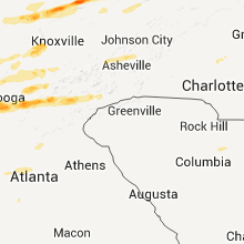
North Carolina
| Local Time | Report Details |
|---|---|
| 11:30 AM EST | Ping Pong Ball sized hail reported near Mocksville, NC, 49.3 miles NNE of Charlotte, NC |
| 7:50 PM EST | Murphy power reports multiple power lines down in cherokee county NC, 60.3 miles S of Knoxville, TN |
| 8:00 PM EST | Multiple power lines down in cherokee county NC, 60.3 miles S of Knoxville, TN |
| 1:25 AM UTC | Numerous trees down in the nantahala are in macon county NC, 55.3 miles SSE of Knoxville, TN |
| 1:26 AM UTC | Quarter sized hail reported near Marshall, NC, 55.8 miles SSW of Bristol, TN, a hail producing storm crossed madison county with the largest hail reported between walnut and mars hill. spotter halfway between those locations reported sounded like |
| 8:30 PM EST | Golf Ball sized hail reported near Topton, NC, 55.3 miles SSE of Knoxville, TN, golf ball sized hail as storm crossed. |
| 8:37 PM EST | Quarter sized hail reported near Mars Hill, NC, 53 miles SSW of Bristol, TN, quarter sized hail lasted a few minutes near yancey county border not far from mars hill. |
| 8:38 PM EST | Golf Ball sized hail reported near Topton, NC, 47.7 miles SSE of Knoxville, TN, golf ball hail and several trees down |
| 1:45 AM UTC | A few trees down near frankli in macon county NC, 52.5 miles WNW of Greenville, SC |
| 1:45 AM UTC | Ping Pong Ball sized hail reported near Franklin, NC, 53.3 miles WNW of Greenville, SC, spotter under the storm reported hail one and a half inch diameter. does not know of any wind damage in his area. |
| 1:48 AM UTC | Golf Ball sized hail reported near Franklin, NC, 53.3 miles WNW of Greenville, SC, golf ball hail and trees down |
| 8:50 PM EST | Golf Ball sized hail reported near Franklin, NC, 51 miles WNW of Greenville, SC, golf ball sized hail fell in or near franklin as storm passed. got a report from a traveler passing through about a mile north of downtown franklin of very strong wind |
| 8:58 PM EST | Hen Egg sized hail reported near Franklin, NC, 45.4 miles WNW of Greenville, SC, fire department in cullasaja had hail larger than golf ball but likely a bit less than tennis ball. therefore...lime sized hail fell at their location. |
| 9:05 PM EST | Golf Ball sized hail reported near Glenville, NC, 40.2 miles NW of Greenville, SC, golf ball sized hail reported in south central jackson county as storm passed. |
| 2:05 AM UTC | Trees down along pine creek road. one tree that fell on a brand new car. debris in the road near pine creek road and cullowhee roa in jackson county NC, 40.2 miles NW of Greenville, SC |
| 2:09 AM UTC | Numerous trees snapped and uprooted at the intersection of pine creek and north norton road in jackson county NC, 41.2 miles NW of Greenville, SC |
| 2:36 AM EST | Charlotte-mecklenburg fire marshall reports damage in far eastern mecklenburg there is damage in the plaza road extension area. officials are in the area and will have in mecklenburg county NC, 9.1 miles ENE of Charlotte, NC |
| 2:37 AM EST | Preliminary reports of six houses damaged and trees and other debris in the road south of harrisburg...generally between robinson church road and 485. damage also noted in cabarrus county NC, 10.6 miles ENE of Charlotte, NC |
| 3:10 AM EST | Two old barns were blown down and one home sustained minor damage on substation roa in stanly county NC, 27.1 miles ENE of Charlotte, NC |
| 8:40 AM UTC | Tree down on a home on emmanuel church road in seagrove. report relayed by emergency manager. time estimated by rada in randolph county NC, 63.5 miles ENE of Charlotte, NC |
| 9:00 AM UTC | Several small to medium softwood trees uprooted and down. small section of tin blown off barn roof. straightline thunderstorm wind gust estimated at 65 mp in chatham county NC, 52.6 miles WSW of Raleigh, NC |
| 9:00 AM UTC | Several small to medium softwood trees uprooted and down. straightline thunderstorm wind gust estimated at 65 mp in randolph county NC, 53.3 miles WSW of Raleigh, NC |
| 9:15 AM UTC | Multiple trees down with damage to a house on glovers church road in chatham county NC, 52.1 miles WSW of Raleigh, NC |
| 9:52 AM UTC | Dispatch reported trees down countywid in polk county NC, 31.6 miles NNE of Greenville, SC |
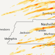
Tennessee
| Local Time | Report Details |
|---|---|
| 11:04 AM CST | Rv blown ove in marion county TN, 16.8 miles NW of Chattanooga, TN |
| 12:10 PM EST | Volunteer electric repotrs multiple pwers line down from trees and lightning countywide in rhea county TN, 51.1 miles NNE of Chattanooga, TN |
| 11:10 AM CST | Quarter sized hail reported near Jasper, TN, 18.2 miles W of Chattanooga, TN |
| 5:40 PM UTC | Numerous trees down. dock and boats damaged. numerous homes with damag in hamilton county TN, 10.7 miles ENE of Chattanooga, TN |
| 12:40 PM EST | Trees and power lines dow in roane county TN, 34.9 miles WSW of Knoxville, TN |
| 12:45 PM EST | Several trees down countywide in roane county TN, 33.6 miles W of Knoxville, TN |
| 5:55 PM UTC | Homes damaged and numerous trees down in the prospect communit in bradley county TN, 29.8 miles ENE of Chattanooga, TN |
| 6:00 PM UTC | Several trees down. trampoline in a tree. power lines down in bradley county TN, 26.5 miles ENE of Chattanooga, TN |
| 6:00 PM UTC | 2 trees down in georgetown in hamilton county TN, 25.5 miles NE of Chattanooga, TN |
| 6:30 PM UTC | Couple of trees down northern hamilton county in hamilton county TN, 25.6 miles NNE of Chattanooga, TN |
| 1:33 PM EST | Quarter sized hail reported near Etowah, TN, 48.3 miles ENE of Chattanooga, TN |
| 6:40 PM UTC | Multiple power lines down from fallen trees and lightning county-wid in mcminn county TN, 48.8 miles NE of Chattanooga, TN |
| 1:40 PM EST | Several trees down county-wid in roane county TN, 38.8 miles WSW of Knoxville, TN |
| 6:50 PM UTC | Between dentville and linsdale on c in mcminn county TN, 48.3 miles ENE of Chattanooga, TN |
| 2:03 PM CST | Quarter sized hail reported near Jackson, TN, 41.9 miles SSW of Mc Kenzie, TN, deep enough to cause fog in the valleys |
| 2:35 PM CST | Golf Ball sized hail reported near Taft, TN, 56.3 miles ENE of Florence, AL, golf ball size hail reported. |
| 2:40 PM CST | Several trees down in fayette county TN, 37.7 miles ESE of Memphis, TN |
| 8:41 PM UTC | Half Dollar sized hail reported near Shelbyville, TN, 54.9 miles SSE of Nashville, TN, emergency management reported large hail 5 miles southeast of shelbyville. |
| 8:42 PM UTC | Trees down across southern carroll county. specifically near goodrum...black gully...and purdy road in carroll county TN, 19.5 miles SSE of Mc Kenzie, TN |
| 8:45 PM UTC | A few stray trees down countywide...mainly of dunlap in sequatchie county TN, 22.8 miles NNW of Chattanooga, TN |
| 8:45 PM UTC | Quarter sized hail reported near Wartrace, TN, 50.7 miles SSE of Nashville, TN, spotter reported one inch hail at wartrace. |
| 8:45 PM UTC | Golf Ball sized hail reported near Wartrace, TN, 50.3 miles SE of Nashville, TN, golfball hail reported at beechgrove by amateur radio. |
| 2:45 PM CST | Golf Ball sized hail reported near Fayetteville, TN, 66.8 miles ENE of Florence, AL, golf ball size hail reported at park city. |
| 8:52 PM UTC | Golf Ball sized hail reported near Wartrace, TN, 52 miles SE of Nashville, TN |
| 2:53 PM CST | Quarter sized hail reported near Grand Junction, TN, 49.1 miles E of Memphis, TN |
| 2:55 PM CST | Golf Ball sized hail reported near Grand Junction, TN, 49.1 miles E of Memphis, TN |
| 3:00 PM CST | Golf Ball sized hail reported near Jasper, TN, 18.3 miles W of Chattanooga, TN, quarter size hail was reported. |
| 9:00 PM UTC | Estimated 75 mph winds produced tree and power line damage. some minor structural damage. in addition...pea hail covered the groun in hardeman county TN, 59.8 miles E of Memphis, TN |
| 9:00 PM UTC | Estimated 75 mph winds produced tree and power line damage. some minor structural damage. in addition...pea hail covered the ground. roof torn off a building on west ma in hardeman county TN, 59.8 miles E of Memphis, TN |
| 3:03 PM CST | Quarter sized hail reported near Jackson, TN, 41.9 miles SSW of Mc Kenzie, TN, deep enough to cause fog in the valleys |
| 9:10 PM UTC | Quarter sized hail reported near Winchester, TN, 48.6 miles WNW of Chattanooga, TN, quarter size hail was reported. |
| 3:12 PM CST | Golf Ball sized hail reported near Middleton, TN, 65.9 miles E of Memphis, TN |
| 3:13 PM CST | Roof blown off a barn and several trees dow in humphreys county TN, 42.2 miles ESE of Mc Kenzie, TN |
| 4:25 PM EST | Quarter sized hail reported near Lenoir City, TN, 22.5 miles WSW of Knoxville, TN, quarter size hail near lenoir city. |
| 3:25 PM CST | Golf Ball sized hail reported near Dickson, TN, 34.2 miles W of Nashville, TN, emergency management reports golfball size hail at dickson. |
| 3:25 PM CST | Baseball sized hail reported near Decherd, TN, 45.6 miles WNW of Chattanooga, TN, baseball size hail was reported. |
| 3:25 PM CST | Possible tornado has produced the following damage in dickson...damage to a waffle house at highway 46 and interstate 40 and homes damaged in southern parts of the city in dickson county TN, 34.2 miles W of Nashville, TN |
| 3:30 PM CST | Half Dollar sized hail reported near Selmer, TN, 56.7 miles WNW of Florence, AL, some nickel to quarter sized hail but mainly half dollar sized hail. |
| 3:30 PM CST | Dickson co ema - reports roof blown off the hampton inn at hwy 46 interstate 40. possible tornad in dickson county TN, 34.2 miles W of Nashville, TN |
| 4:30 PM EST | Volunteer electric reports multiple power lines down from rees and lightning across miegs and rhea county in rhea county TN, 51.1 miles NNE of Chattanooga, TN |
| 3:35 PM CST | Golf Ball sized hail reported near Burns, TN, 30.9 miles W of Nashville, TN, golfball size hail reported 3 to 4 miles east of dickson,at intersection of highway 47 and old columbia road. |
| 3:40 PM CST | Trees down and power out in southern cheatham county. reported by cheatham county emergency managemen in cheatham county TN, 18.6 miles WSW of Nashville, TN |
| 3:44 PM CST | Tea Cup sized hail reported near Stantonville, TN, 49.5 miles WNW of Florence, AL |
| 3:45 PM CST | Golf Ball sized hail reported near Stantonville, TN, 49.5 miles WNW of Florence, AL, golfball hail with 60 mph winds producing severe tree damage and broken windows |
| 9:45 PM UTC | Accompanied by golfball hail ...noted in previous report in mcnairy county TN, 49.5 miles WNW of Florence, AL |
| 3:50 PM CST | Trees down over southern dickson count in dickson county TN, 34.5 miles WSW of Nashville, TN |
| 3:55 PM CST | Golf Ball sized hail reported near Nashville, TN, 6.1 miles SW of Nashville, TN, spotter reportede golfball hail at bellevue,in southwest davidson county. |
| 3:56 PM CST | Golf Ball sized hail reported near Nashville, TN, 10.5 miles SW of Nashville, TN, golfball sized hail reported on interstate 40 and exit 196 in bellevue. |
| 10:00 PM UTC | Half Dollar sized hail reported near Savannah, TN, 40.6 miles NW of Florence, AL, hail fell in the community of olivet. |
| 4:00 PM CST | Ping Pong Ball sized hail reported near Nashville, TN, 6.5 miles SW of Nashville, TN, report of ping pong sized hail in bellevue. |
| 4:00 PM CST | Golf Ball sized hail reported near Nashville, TN, 5.6 miles SW of Nashville, TN, hail broke house windows |
| 10:00 PM UTC | A few small trees down and tree limbs down along with some shingle damage in the cravens area of savanna in hardin county TN, 43.2 miles NW of Florence, AL |
| 4:03 PM CST | Quarter sized hail reported near Nashville, TN, 0.5 miles ENE of Nashville, TN, trained spotter reported quarter sized hail 1 m e of nashville. |
| 4:03 PM CST | Golf Ball sized hail reported near Nashville, TN, 0.2 miles NNW of Nashville, TN, hail up to golfball size reported at the nashville emeregency operations center. at least two dozen vehicles damaged. |
| 4:04 PM CST | Quarter sized hail reported near Nashville, TN, 6.9 miles SW of Nashville, TN |
| 4:06 PM CST | Half Dollar sized hail reported near Nashville, TN, 1.2 miles W of Nashville, TN, half dollar sized hail reported 1 m w of nashville. |
| 4:06 PM CST | Golf Ball sized hail reported near Nashville, TN, 4 miles S of Nashville, TN, golf ball sized hail reported at lipscomb university. |
| 4:07 PM CST | Golf Ball sized hail reported near Nashville, TN, 0.2 miles NNW of Nashville, TN |
| 4:08 PM CST | Quarter sized hail reported near Nashville, TN, 0.2 miles NNW of Nashville, TN |
| 10:08 PM UTC | Half Dollar sized hail reported near Savannah, TN, 38 miles NW of Florence, AL, half dollar size hail covering ground in community of olive hill. |
| 10:08 PM UTC | Half Dollar sized hail reported near Savannah, TN, 38 miles NW of Florence, AL, quarter size hail covering ground in community of olive hill. |
| 4:10 PM CST | Ping Pong Ball sized hail reported near Nashville, TN, 3.3 miles S of Nashville, TN |
| 4:10 PM CST | Golf Ball sized hail reported near Nashville, TN, 0.2 miles NNW of Nashville, TN, golfball hail at 23rd avenue and patterson in nashville. |
| 4:10 PM CST | Golf Ball sized hail reported near Nashville, TN, 3.8 miles SE of Nashville, TN, numerous reports of golfball size hail around the nashville airport. |
| 4:10 PM CST | Hen Egg sized hail reported near Nashville, TN, 3.3 miles S of Nashville, TN |
| 4:16 PM CST | Quarter sized hail reported near Nashville, TN, 4.6 miles SE of Nashville, TN, trained spotter reports quarter sized hail in antioch. |
| 4:18 PM CST | Golf Ball sized hail reported near Hermitage, TN, 11.7 miles E of Nashville, TN |
| 4:25 PM CST | Hen Egg sized hail reported near Mt Juliet, TN, 14.5 miles E of Nashville, TN, hen egg size hail reported by a spotter at providence,about a mile south of downtown mount juliet. |
| 4:30 PM CST | Hen Egg sized hail reported near Lebanon, TN, 27.5 miles E of Nashville, TN, hen egg size hail reported just east of lebanon at 8000 trousdale ferry pike. homes and vehicles damaged. |
| 5:30 PM EST | Volunteer electric reports multiple power lines down across roane county from trees and lightning in roane county TN, 33.6 miles W of Knoxville, TN |
| 4:34 PM CST | Hen Egg sized hail reported near Lebanon, TN, 25.8 miles E of Nashville, TN, hen egg size hail reported by a spotter on the western side of lebanon. |
| 4:34 PM CST | Hen Egg sized hail reported near Lebanon, TN, 23.6 miles E of Nashville, TN, 2 inch hail reported by spotter. |
| 4:37 PM CST | Quarter sized hail reported near Lebanon, TN, 26.1 miles E of Nashville, TN, quarter size hail reported by spotter just north of lebanon. |
| 10:45 PM UTC | Multiple trees down around 845pm near highway 27 in rhea county TN, 35 miles NNE of Chattanooga, TN |
| 10:45 PM UTC | Couple of trees down northern part of hamiton county in hamilton county TN, 25.6 miles NNE of Chattanooga, TN |
| 10:45 PM UTC | Trees down countywide bledsoe county in bledsoe county TN, 30.1 miles NNE of Chattanooga, TN |
| 4:53 PM CST | Baseball sized hail reported near Lebanon, TN, 30.8 miles E of Nashville, TN, baseball size hail broke windows on house in tuckers crossroads area |
| 4:55 PM CST | Half Dollar sized hail reported near Carthage, TN, 47.3 miles E of Nashville, TN, spotter reported half dollar size hail at carthage. |
| 10:55 PM UTC | Golf Ball sized hail reported near Sherwood, TN, 35.3 miles W of Chattanooga, TN, golfball size hail reported. |
| 5:00 PM CST | Quarter sized hail reported near South Pittsburg, TN, 22.8 miles W of Chattanooga, TN, quarter size hail in souths pittsburg. |
| 5:00 PM CST | Baseball sized hail reported near Jasper, TN, 20.5 miles W of Chattanooga, TN |
| 5:06 PM CST | Golf Ball sized hail reported near Jasper, TN, 18.2 miles W of Chattanooga, TN, spotter reported golfball-size hail at the grandview medical center. |
| 6:08 PM EST | Golf Ball sized hail reported near Jellico, TN, 44.3 miles NNW of Knoxville, TN, golf ball size hail in downtown jellico. |
| 11:10 PM UTC | Trees down near dayton in rhea county TN, 35 miles NNE of Chattanooga, TN |
| 5:11 PM CST | A tree fell on a house on rally hill road...also a light pole was downed on highway 31 near columbi in maury county TN, 37.3 miles SSW of Nashville, TN |
| 5:11 PM CST | Golf Ball sized hail reported near Lynnville, TN, 54.9 miles NE of Florence, AL |
| 6:20 PM EST | Trees down on power line in mcminn county TN, 47.1 miles SW of Knoxville, TN |
| 5:25 PM CST | *** 3 inj *** extensive damage and 3 injuries in dodsons branch. reported by 911 center. possible tornad in jackson county TN, 70.4 miles E of Nashville, TN |
| 11:25 PM UTC | Possible tornado in the dodsons branch community.....27 houses with major damage plus an additional 38 houses with minor to major damage. damage area is 1 mile deep by in jackson county TN, 71.1 miles E of Nashville, TN |
| 6:30 PM EST | Quarter sized hail reported near Chattanooga, TN, 4.5 miles NNE of Chattanooga, TN |
| 5:30 PM CST | Putnam county emergency management reported the following damage...two houses destroyed in northern putnam county near the jackson county line. possible tornado at zion in putnam county TN, 71.2 miles E of Nashville, TN |
| 5:30 PM CST | House and barn destroyed at 135 cummins mills road in putnam county. possible tornad in jackson county TN, 66.6 miles E of Nashville, TN |
| 6:31 PM EST | Golf Ball sized hail reported near Chattanooga, TN, 3.2 miles ENE of Chattanooga, TN |
| 5:32 PM CST | Over 100 trees down and people trapped near east white hall road 6 m n of cookevill in putnam county TN, 71.1 miles E of Nashville, TN |
| 6:36 PM EST | Tennis Ball sized hail reported near Chattanooga, TN, 3.2 miles ENE of Chattanooga, TN, tennis ball size hail on highway 27 in chattanooga. |
| 6:43 PM EST | Half Dollar sized hail reported near Chattanooga, TN, 9.7 miles E of Chattanooga, TN |
| 6:45 PM EST | From volunteer electric reported multiple power lines down from trees and lightnin in mcminn county TN, 47.1 miles SW of Knoxville, TN |
| 5:53 PM CST | Golf Ball sized hail reported near Ethridge, TN, 41.7 miles NNE of Florence, AL, lawrence county ema reported golfball size hail at ethridge. |
| 7:00 PM EST | Quarter sized hail reported near Maryville, TN, 14.8 miles S of Knoxville, TN, quarter size hail in maryville |
| 6:00 PM CST | Half Dollar sized hail reported near Ethridge, TN, 41.7 miles NNE of Florence, AL, silver dollar size hail reported at ethridge. |
| 6:00 PM CST | Baseball sized hail reported near Summertown, TN, 49.3 miles NNE of Florence, AL, emergency manager reports baseball size hail in campbellsville tn. |
| 6:00 PM CST | Barn destroyed. neighbors house roof ripped off. near the intersection of hardys chapel road and crawfords chapel roa in overton county TN, 77.8 miles E of Nashville, TN |
| 6:00 PM CST | Coop observer reports house destroyed near hardys chapel road near the putnam and overton county line. people trapped in hous in overton county TN, 76 miles E of Nashville, TN |
| 6:03 PM CST | Golf Ball sized hail reported near Shelbyville, TN, 50.2 miles SSE of Nashville, TN, amateur radio operator reported golf ball sized hail in shelbyville. |
| 6:07 PM CST | Quarter sized hail reported near Wartrace, TN, 52.1 miles SE of Nashville, TN, quarter size hail reported by amateur radio operator. |
| 12:25 AM UTC | Quarter sized hail reported near Wartrace, TN, 52 miles SE of Nashville, TN, quarter size hail reported 6ene wartrace. |
| 12:25 AM UTC | Several trees dow in polk county TN, 45.1 miles E of Chattanooga, TN |
| 6:25 PM CST | *** 3 inj *** extensive damage and 3 injuries in dodsons branch. reported by 911 center. possible tornad in jackson county TN, 70.4 miles E of Nashville, TN |
| 12:29 AM UTC | Quarter sized hail reported near Lewisburg, TN, 49.5 miles S of Nashville, TN, amateur radio operator reports quarter size hail between lewisburg and interstate 65. |
| 7:30 PM EST | Golf Ball sized hail reported near Oneida, TN, 49.7 miles NW of Knoxville, TN |
| 6:45 PM CST | Golf Ball sized hail reported near Shelbyville, TN, 53.8 miles SSE of Nashville, TN, golfball hail reported between the communities of pleasant grove and richmond,8 miles southwest of shelbyville. |
| 7:50 PM EST | Quarter sized hail reported near McDonald, TN, 19.2 miles ENE of Chattanooga, TN |
| 8:00 PM EST | Half Dollar sized hail reported near Cleveland, TN, 25.8 miles E of Chattanooga, TN |
| 8:00 PM EST | Golf Ball sized hail reported near Jellico, TN, 44.3 miles NNW of Knoxville, TN |
| 8:00 PM EST | Baseball sized hail reported near Jellico, TN, 44.3 miles NNW of Knoxville, TN, baseball hail in jellico...hail damage to cars and homes. |
| 7:03 PM CST | Hen Egg sized hail reported near Spencer, TN, 48.5 miles N of Chattanooga, TN, confirmed by photos. location and time approximate. |
| 7:38 PM CST | Quarter sized hail reported near Crossville, TN, 59.2 miles N of Chattanooga, TN, quarter sized hail report by amatuer radio. located near the town of lantana. |
| 9:15 PM EST | Several trees down countywide in roane county TN, 33.6 miles W of Knoxville, TN |
| 9:15 PM EST | Spotter report 60 mph winds and 0.75 inch hail in roane county TN, 33.6 miles W of Knoxville, TN |
| 9:24 PM EST | Quarter sized hail reported near Oliver Springs, TN, 24.1 miles WNW of Knoxville, TN |
| 9:35 PM EST | Ping Pong Ball sized hail reported near Clinton, TN, 12.4 miles WNW of Knoxville, TN, ping pong ball sized hail near claxton. |
| 9:40 PM EST | Quarter sized hail reported near Clinton, TN, 14.7 miles NW of Knoxville, TN |
| 9:45 PM EST | Several trees dow in grainger county TN, 17.9 miles NE of Knoxville, TN |
| 10:15 PM EST | Numerous trees down in the eastern half of the count in sevier county TN, 17.1 miles SE of Knoxville, TN |
| 10:45 PM EST | Several trees dow in cocke county TN, 39 miles ESE of Knoxville, TN |
| 10:45 PM EST | Several trees dow in cocke county TN, 41 miles E of Knoxville, TN |
| 11:00 PM EST | Seevral trees dow in hawkins county TN, 27.5 miles W of Bristol, TN |
| 10:45 PM CST | Couple trees down countywide in sequatchie county TN, 30.4 miles NNW of Chattanooga, TN |
South Carolina
| Local Time | Report Details |
|---|---|
| 6:00 PM UTC | Several trees down. trampoline in a tree. power lines down in greenville county SC, 17 miles NNE of Greenville, SC |
| 2:11 AM EST | Half Dollar sized hail reported near Roebuck, SC, 36.5 miles E of Greenville, SC, public report of hail an inch and a quarter in diameter which is half dollar sized in roebuck. |
| 8:40 AM UTC | One tree down on bethlehem rd in abbeville county SC, 37.4 miles SSE of Greenville, SC |
| 9:12 AM UTC | Trees blocking roadwa in greenwood county SC, 43.6 miles NNW of Augusta, GA |
| 9:20 AM UTC | Trees down on county line roa in greenwood county SC, 43.5 miles N of Augusta, GA |
| 9:26 AM UTC | Dispatch reported a couple of trees down hwy 22 in mccormick county SC, 30.4 miles NNW of Augusta, GA |
| 9:28 AM UTC | Dispatch reported a couple of trees down in the west end of the county on garret roa in edgefield county SC, 21.6 miles N of Augusta, GA |
| 9:34 AM UTC | Trees down on gervais street in greenwood county SC, 47.7 miles N of Augusta, GA |
| 9:34 AM UTC | Tree down on louden rd in greenwood county SC, 46.4 miles N of Augusta, GA |
| 9:52 AM UTC | Dispatch reported trees down countywid in saluda county SC, 37.8 miles NNE of Augusta, GA |
| 10:06 AM UTC | Dispatch reported trees and powerlines down in newberry and pomeri in newberry county SC, 63.2 miles NNE of Augusta, GA |
| 10:19 AM UTC | Dispatch reported trees down around the jenkinsville are in fairfield county SC, 68.2 miles SSW of Charlotte, NC |
| 5:33 AM EST | Dispatch reported a few trees down on hwys 34 and 6 in fairfield county SC, 63.3 miles S of Charlotte, NC |
| 10:36 AM UTC | Skywarn spotter reported antennas and trees dow in richland county SC, 64.3 miles NE of Augusta, GA |
| 10:38 AM UTC | Trees in roadway at 1500 corley mill roa in lexington county SC, 55.5 miles NE of Augusta, GA |
| 10:39 AM UTC | Trees blocking roadway near goodsprings road and hwy 1 in aiken county SC, 13.1 miles NE of Augusta, GA |
| 10:43 AM UTC | Skywarn spotter reported some trees down in forest acre in richland county SC, 68.7 miles NE of Augusta, GA |
| 10:47 AM UTC | Dispatch reported trees down in elgi in kershaw county SC, 73.4 miles S of Charlotte, NC |
| 10:47 AM UTC | Trees blocking roadway on burning tree road near bush river roa in richland county SC, 66.3 miles NE of Augusta, GA |
| 5:56 AM EST | Dispatch reported a couple of trees and powerlines down on mill st and also hwy 97 near the land fil in kershaw county SC, 67.6 miles S of Charlotte, NC |
| 11:02 AM UTC | Trees down at broad river road and haviland circl in richland county SC, 63.9 miles NE of Augusta, GA |
| 11:11 AM UTC | Trees down on calks ferry road near pond branch roa in lexington county SC, 46.9 miles NE of Augusta, GA |
| 11:15 AM UTC | Tree down across whippoorwill r in darlington county SC, 69.8 miles SE of Charlotte, NC |
| 11:19 AM UTC | Diapatch reported trees down on lee state park road north northwest of bishopvill in lee county SC, 71.7 miles SSE of Charlotte, NC |
| 11:21 AM UTC | Trees down at beatty road and morningside driv in lexington county SC, 60.8 miles NE of Augusta, GA |
| 11:28 AM UTC | Tree on roadway at 1261 e old camden road in darlington county SC, 70.6 miles SE of Charlotte, NC |
| 11:31 AM UTC | Tree on roadway at whipporwill road and new market road in darlington county SC, 70.6 miles SE of Charlotte, NC |
| 11:43 AM UTC | Tree on roadway at 2160 resting place road in darlington county SC, 67.9 miles N of Charleston, SC |
Kentucky
| Local Time | Report Details |
|---|---|
| 1:00 PM EST | 2 trees down in georgetown in harlan county KY, 50.4 miles WNW of Bristol, TN |
| 7:30 PM UTC | Part of roof barn blown off between possum trot and reidland. late repor in marshall county KY, 60.7 miles N of Mc Kenzie, TN |
| 7:33 PM UTC | Measured at barkley regional airport aso in mccracken county KY, 47 miles ESE of Cape Girardeau, MO |
| 7:38 PM UTC | Roof blown off of home and laying across highway 268 just west of hwy 62 intersectio in mccracken county KY, 47 miles ESE of Cape Girardeau, MO |
| 1:40 PM CST | Golf Ball sized hail reported near Morganfield, KY, 27.9 miles SW of Evansville, IN, golf ball size hail reported. |
| 7:43 PM UTC | Quarter sized hail reported near Paducah, KY, 52.4 miles ESE of Cape Girardeau, MO, quarter size hail reported on south side of town as well as downtown. |
| 1:52 PM CST | Quarter sized hail reported near Smithland, KY, 64.1 miles E of Cape Girardeau, MO, quarter size hail reported by state police. |
| 1:55 PM CST | Golf Ball sized hail reported near Corydon, KY, 14.1 miles SSW of Evansville, IN |
| 7:55 PM UTC | Wind gusts estimated 60 to 70 mph near lourdes hospital at exit in mccracken county KY, 52.4 miles ESE of Cape Girardeau, MO |
| 2:00 PM CST | Golf Ball sized hail reported near Henderson, KY, 9.5 miles S of Evansville, IN, golf ball size hail reported. |
| 2:02 PM CST | Golf Ball sized hail reported near Henderson, KY, 9.5 miles S of Evansville, IN |
| 2:08 PM CST | Golf Ball sized hail reported near Clay, KY, 37 miles SSW of Evansville, IN, golf ball size hail reported. |
| 8:10 PM UTC | Public report of shingles blown off a hom in mccracken county KY, 59.5 miles ESE of Cape Girardeau, MO |
| 2:15 PM CST | Golf Ball sized hail reported near Salem, KY, 61.2 miles SW of Evansville, IN, late report. golf ball size hail reported. |
| 2:21 PM CST | Quarter sized hail reported near Owensboro, KY, 28.5 miles ESE of Evansville, IN, nickel to quarter size hail reported in the community. |
| 2:25 PM CST | Half Dollar sized hail reported near Calhoun, KY, 25.1 miles SSE of Evansville, IN, half dollar hail reported in the community of beach grove. |
| 2:25 PM CST | Storm damage reported in daviess county KY, 28.5 miles ESE of Evansville, IN |
| 8:28 PM UTC | Power lines dow in hancock county KY, 36.4 miles E of Evansville, IN |
| 2:35 PM CST | Quarter sized hail reported near Madisonville, KY, 44 miles S of Evansville, IN, quarter size hail reported. damage to gas station canopy and signs reported. |
| 2:37 PM CST | Golf Ball sized hail reported near Madisonville, KY, 44 miles S of Evansville, IN, gofl ball size hail reported along with wind gusts estimated 60 mph. |
| 8:37 PM UTC | Roof and tree damage reported in the community. several sections of town without powe in hopkins county KY, 44 miles S of Evansville, IN |
| 2:39 PM CST | Golf Ball sized hail reported near Slaughters, KY, 33.8 miles S of Evansville, IN, golf ball size hail reported. |
| 8:40 PM UTC | Reported by ky mesone in hopkins county KY, 44 miles S of Evansville, IN |
| 8:40 PM UTC | Home on jaygeo street lost back of roof and the other side is peeled back. time estimated. roof of the ky trans. cabinet district 2 headquarters ripped off. several hwy in hopkins county KY, 44 miles S of Evansville, IN |
| 2:42 PM CST | Dime size hail reported with this stor in hopkins county KY, 44.4 miles S of Evansville, IN |
| 8:50 PM UTC | Golf Ball sized hail reported near Cadiz, KY, 64 miles NE of Mc Kenzie, TN, golf ball size hail damaged roof of homes along princeton road and stone road. late report. |
| 2:50 PM CST | Late report...roof blown off of home. fire/rescue is respondin in muhlenberg county KY, 46.5 miles SSE of Evansville, IN |
| 2:50 PM CST | Roof removed from barn near millport at hwy 175 near hwy 423 intersectio in muhlenberg county KY, 45.7 miles SSE of Evansville, IN |
| 2:51 PM CST | Dime size hail reported with the storm along with downed tree in muhlenberg county KY, 46.5 miles SSE of Evansville, IN |
| 2:52 PM CST | Roof completely ripped off house/garage - hwy 8 in muhlenberg county KY, 45.3 miles SSE of Evansville, IN |
| 2:52 PM CST | Large shed destroyed near hwy 175 near lynn city r in muhlenberg county KY, 46.1 miles SSE of Evansville, IN |
| 8:53 PM UTC | Barn totally destroyed - fairview roa in muhlenberg county KY, 46 miles SSE of Evansville, IN |
| 2:55 PM CST | Pea size hail reported with this stor in trigg county KY, 55.8 miles NNE of Mc Kenzie, TN |
| 8:56 PM UTC | Reported on ky mesone in muhlenberg county KY, 56.9 miles SSE of Evansville, IN |
| 2:56 PM CST | Roofs off homes and cars overturne in ohio county KY, 49.3 miles SE of Evansville, IN |
| 2:57 PM CST | Barn and silo damage...structural damage to outbuilding and several power lines down on highway 27 in trigg county KY, 67.2 miles NE of Mc Kenzie, TN |
| 3:00 PM CST | Quarter sized hail reported near Hartford, KY, 51.8 miles SE of Evansville, IN, funnel cloud spotted. |
| 9:00 PM UTC | Half Dollar sized hail reported near Carrollton, KY, 46 miles SW of Cincinnati, OH |
| 9:00 PM UTC | Roofs off home in ohio county KY, 51.8 miles SE of Evansville, IN |
| 9:01 PM UTC | A 30 by 60 foot old barn and a single-wide home were destroyed on willard wilson road. one large oak tree was downed along with several other smaller trees. further dow in trimble county KY, 44 miles NNE of Louisville, KY |
| 9:03 PM UTC | On hi-grove hill road... there was a very concentrated area of snapped trees. a power line was down... and a gutter was partially ripped off a garag in trimble county KY, 45.8 miles NNE of Louisville, KY |
| 4:04 PM EST | Golf Ball sized hail reported near Carrollton, KY, 46.9 miles SW of Cincinnati, OH, at the intersection of hwy 55 and hwy 389 - relayed from wfo louisville |
| 4:05 PM EST | Baseball sized hail reported near Warsaw, KY, 30.1 miles SW of Cincinnati, OH, time estimated from radar. |
| 9:05 PM UTC | From the kentucky mesonet sit in ohio county KY, 53.8 miles SE of Evansville, IN |
| 9:05 PM UTC | Storm damage reported in ohio county KY, 53.8 miles SE of Evansville, IN |
| 4:06 PM EST | Baseball sized hail reported near Brandenburg, KY, 25.3 miles W of Louisville, KY |
| 9:07 PM UTC | Storm damage reported in meade county KY, 25.3 miles W of Louisville, KY |
| 4:09 PM EST | Half Dollar sized hail reported near Brandenburg, KY, 20.9 miles W of Louisville, KY |
| 9:12 PM UTC | Tree damage in ohio county KY, 54.2 miles SE of Evansville, IN |
| 9:12 PM UTC | Trees down in hardin county KY, 14.9 miles WSW of Louisville, KY |
| 9:13 PM UTC | Thunderstorm winds caused power poles to lean on bishops lane east of campbellsbur in henry county KY, 49.9 miles NE of Louisville, KY |
| 4:14 PM EST | Grapefruit sized hail reported near Worthville, KY, 45.9 miles SW of Cincinnati, OH, time estimated by radar. |
| 3:15 PM CST | Quarter sized hail reported near Horse Branch, KY, 63.1 miles SE of Evansville, IN, at renfrow |
| 9:17 PM UTC | Several six inch limbs were down 2 miles east of port royal on route 38 in henry county KY, 48.4 miles SW of Cincinnati, OH |
| 4:17 PM EST | Golf Ball sized hail reported near Gravel Switch, KY, 46.1 miles SE of Louisville, KY |
| 3:18 PM CST | Golf Ball sized hail reported near Leitchfield, KY, 47 miles SW of Louisville, KY |
| 3:20 PM CST | Storm damage reported in grayson county KY, 57.7 miles SW of Louisville, KY |
| 3:21 PM CST | Vacant mobile home was turned over from straight line winds. power outages across the county as wel in grayson county KY, 57.7 miles SW of Louisville, KY |
| 3:21 PM CST | Quarter sized hail reported near Caneyville, KY, 57.7 miles SW of Louisville, KY, *** 1 inj *** |
| 3:22 PM CST | Golf Ball sized hail reported near Caneyville, KY, 57.7 miles SW of Louisville, KY |
| 4:25 PM EST | Hen Egg sized hail reported near Jonesville, KY, 34.8 miles SSW of Cincinnati, OH, near jonesville. |
| 9:26 PM UTC | Dime size hail reported with this storm along pennyrile parkway and hwy 8 in christian county KY, 64.1 miles S of Evansville, IN |
| 9:27 PM UTC | Quarter sized hail reported near Dry Ridge, KY, 29.9 miles S of Cincinnati, OH |
| 4:28 PM EST | Golf Ball sized hail reported near Shepherdsville, KY, 0.4 miles ENE of Louisville, KY |
| 4:29 PM EST | Baseball sized hail reported near New Liberty, KY, 40.1 miles SSW of Cincinnati, OH, some reports of structural damage also in new liberty but not specific at this time |
| 9:30 PM UTC | Quarter sized hail reported near Williamstown, KY, 32.9 miles SSW of Cincinnati, OH, reported near four corners. |
| 9:30 PM UTC | Spotter report of extensive structural damage north of long ridge. possible injurie in owen county KY, 37.6 miles SSW of Cincinnati, OH |
| 9:30 PM UTC | Straight-lined winds downed a few trees on deer lick road. wind speeds estimated at 60 mph. survey done by nws nashvill in logan county KY, 59.4 miles NNW of Nashville, TN |
| 4:31 PM EST | Tennis Ball sized hail reported near New Liberty, KY, 37.2 miles SSW of Cincinnati, OH |
| 9:32 PM UTC | Semi blown over at mile marker 95 on interstae 6 in hardin county KY, 21.5 miles SSW of Louisville, KY |
| 4:33 PM EST | Golf Ball sized hail reported near Shepherdsville, KY, 5.3 miles E of Louisville, KY |
| 4:35 PM EST | Golf Ball sized hail reported near Mt Washington, KY, 10.1 miles ENE of Louisville, KY |
| 4:35 PM EST | 1 foot to 2 foot pieces of plywood fallnig from the sky in boone county KY, 14 miles SW of Cincinnati, OH |
| 9:40 PM UTC | Pockets of widespread damage...including some reports of injuries. specific locations not known at this time. report from dry ridge state police pos in grant county KY, 29.9 miles S of Cincinnati, OH |
| 4:40 PM EST | Tennis Ball sized hail reported near Mt Washington, KY, 10.1 miles ENE of Louisville, KY |
| 9:41 PM UTC | Storm damage reported in hardin county KY, 24.8 miles SSW of Louisville, KY |
| 9:43 PM UTC | Storm damage reported in spencer county KY, 20.4 miles ENE of Louisville, KY |
| 9:44 PM UTC | Garage heavily damaged on parkers grove rd in kenton county KY, 20.6 miles S of Cincinnati, OH |
| 4:45 PM EST | Golf Ball sized hail reported near Lancaster, KY, 37 miles W of Irvine, KY |
| 9:45 PM UTC | Trees down in lincoln county KY, 40.1 miles WSW of Irvine, KY |
| 3:48 PM CST | Large shallow rooted hardwood tree uprooted in simpson county KY, 43.2 miles NNE of Nashville, TN |
| 3:49 PM CST | Storm damage reported in christian county KY, 50.5 miles NW of Nashville, TN |
| 9:49 PM UTC | Tree fell on a house at 138 n maple st in hardin county KY, 33 miles SSW of Louisville, KY |
| 9:50 PM UTC | Two trees dow in kenton county KY, 20.5 miles S of Cincinnati, OH |
| 9:53 PM UTC | Lsr in hart county KY, 42 miles S of Louisville, KY |
| 9:53 PM UTC | Trees and power lines dow in hart county KY, 39.4 miles S of Louisville, KY |
| 3:53 PM CST | Trees dow in simpson county KY, 43.1 miles NNE of Nashville, TN |
| 9:54 PM UTC | Lsr in hart county KY, 41.9 miles S of Louisville, KY |
| 4:55 PM EST | Wind gust measured at the kentucky mesonet site in owen count in owen county KY, 40.4 miles SSW of Cincinnati, OH |
| 9:55 PM UTC | On hwy 357 s... one mile south of hwy 728... a single-wide mobile home was destroyed... with the roof and most of the exterior siding gon in hart county KY, 42.3 miles S of Louisville, KY |
| 4:55 PM EST | Golf Ball sized hail reported near Taylorsville, KY, 20.8 miles E of Louisville, KY |
| 4:56 PM EST | Half Dollar sized hail reported near Shelbyville, KY, 31 miles ENE of Louisville, KY |
| 9:56 PM UTC | Storm damage reported in shelby county KY, 31 miles ENE of Louisville, KY |
| 4:59 PM EST | Tennis Ball sized hail reported near Mt Eden, KY, 31.6 miles E of Louisville, KY, the emergency manager reported that tennis ball sized hail damaged numerous buildings and cars in mount eden...which is on the spencer anderson county line. |
| 5:00 PM EST | Quarter sized hail reported near Waddy, KY, 36.6 miles ENE of Louisville, KY |
| 10:02 PM UTC | Roof damage in warren county KY, 58.4 miles NNE of Nashville, TN |
| 5:02 PM EST | Quarter sized hail reported near Waddy, KY, 36.6 miles ENE of Louisville, KY |
| 5:04 PM EST | Golf Ball sized hail reported near Waddy, KY, 36.6 miles ENE of Louisville, KY |
| 10:05 PM UTC | Quarter sized hail reported near Berea, KY, 17.9 miles WSW of Irvine, KY |
| 5:07 PM EST | Golf Ball sized hail reported near Frankfort, KY, 46.1 miles ENE of Louisville, KY |
| 10:07 PM UTC | Power line down in clark county KY, 23.8 miles NNW of Irvine, KY |
| 4:07 PM CST | Straight-line winds destroyed a barn just southeast of cave springs. also had minor roof siding damage to a home in the area along with severeal trees down. peak wind s in logan county KY, 44.1 miles NNW of Nashville, TN |
| 5:08 PM EST | Media reports trailers damaged...power lines down and light poles down near aa ky highway near flagg spring in campbell county KY, 21 miles SE of Cincinnati, OH |
| 5:08 PM EST | Golf Ball sized hail reported near Frankfort, KY, 48.2 miles ENE of Louisville, KY |
| 5:10 PM EST | Golf Ball sized hail reported near Lawrenceburg, KY, 43.4 miles E of Louisville, KY |
| 5:10 PM EST | Golf Ball sized hail reported near Frankfort, KY, 48.2 miles ENE of Louisville, KY |
| 10:10 PM UTC | Storm damage reported in nelson county KY, 23.4 miles SSE of Louisville, KY |
| 10:10 PM UTC | Storm damage reported in warren county KY, 57.3 miles NNE of Nashville, TN |
| 5:12 PM EST | Golf Ball sized hail reported near Campbellsville, KY, 40.8 miles SSE of Louisville, KY |
| 5:15 PM EST | Baseball sized hail reported near Winchester, KY, 13.1 miles NNW of Irvine, KY |
| 10:20 PM UTC | A mobile home blown off foundatio in fleming county KY, 57.5 miles NNE of Irvine, KY |
| 10:20 PM UTC | Half Dollar sized hail reported near Clay City, KY, 11.3 miles NNE of Irvine, KY, hail ranging from dime to half dollar size covering the ground,approximately 2.5 miles norht on route 11 towards mt sterling. |
| 10:20 PM UTC | Half Dollar sized hail reported near Clay City, KY, 13.3 miles N of Irvine, KY |
| 5:21 PM EST | Baseball sized hail reported near Jeffersonville, KY, 18 miles N of Irvine, KY, baseball size hail along highway 11 between levee and powell county line. |
| 5:23 PM EST | Golf Ball sized hail reported near Georgetown, KY, 46.7 miles NW of Irvine, KY |
| 10:23 PM UTC | Storm damage reported in scott county KY, 46.7 miles NW of Irvine, KY |
| 4:25 PM CST | Storm damage reported in barren county KY, 69 miles S of Louisville, KY |
| 5:25 PM EST | Quarter sized hail reported near Georgetown, KY, 46.7 miles NW of Irvine, KY |
| 5:25 PM EST | Baseball sized hail reported near Jeffersonville, KY, 20.2 miles NNE of Irvine, KY, baseball sized hail in jeffersonville. |
| 10:26 PM UTC | Quarter sized hail reported near Glasgow, KY, 69 miles S of Louisville, KY |
| 5:26 PM EST | Golf Ball sized hail reported near Lawrenceburg, KY, 43.4 miles E of Louisville, KY |
| 5:26 PM EST | Golf Ball sized hail reported near Lawrenceburg, KY, 45.6 miles E of Louisville, KY |
| 10:28 PM UTC | Quarter sized hail reported near Mt Sterling, KY, 23.6 miles N of Irvine, KY |
| 4:29 PM CST | Quarter sized hail reported near Glasgow, KY, 70.2 miles NE of Nashville, TN |
| 10:30 PM UTC | Large trees down...gutters ripped away from houses...fence laid over and also a porch damaged on a hous in rowan county KY, 44 miles NE of Irvine, KY |
| 10:32 PM UTC | Golf Ball sized hail reported near Means, KY, 20.9 miles NE of Irvine, KY |
| 10:32 PM UTC | Storm damage reported in warren county KY, 58.4 miles NNE of Nashville, TN |
| 10:35 PM UTC | Half Dollar sized hail reported near Jeffersonville, KY, 21.2 miles NNE of Irvine, KY, half dollar size hail was reported. |
| 5:35 PM EST | Golf Ball sized hail reported near Gravel Switch, KY, 46.1 miles SE of Louisville, KY |
| 5:35 PM EST | Golf Ball sized hail reported near Lancaster, KY, 31.5 miles W of Irvine, KY |
| 4:38 PM CST | Power lines down and poles snappe in edmonson county KY, 58.3 miles SSW of Louisville, KY |
| 4:39 PM CST | Golf Ball sized hail reported near Munfordville, KY, 49.8 miles SSW of Louisville, KY |
| 10:40 PM UTC | Golf Ball sized hail reported near Frenchburg, KY, 26 miles NE of Irvine, KY, golfball size hail was reported. |
| 10:40 PM UTC | Golf Ball sized hail reported near Sharpsburg, KY, 34.6 miles N of Irvine, KY, golfball sized hail reported near olympia...bethel and sharpsburg. |
| 10:40 PM UTC | Heavy damage to church on sr 10 in pendleton county KY, 22.3 miles SSE of Cincinnati, OH |
| 10:40 PM UTC | Barn destroyed from wind damag in rowan county KY, 51.4 miles NE of Irvine, KY |
| 10:41 PM UTC | Golf Ball sized hail reported near Frenchburg, KY, 26 miles NE of Irvine, KY, golfball size hail covering the ground |
| 5:42 PM EST | Quarter sized hail reported near Paint Lick, KY, 24.5 miles W of Irvine, KY |
| 4:42 PM CST | Golf Ball sized hail reported near Munfordville, KY, 49.8 miles SSW of Louisville, KY |
| 10:43 PM UTC | Trees wire lines down in str in mccreary county KY, 62.1 miles NNW of Knoxville, TN |
| 10:43 PM UTC | Trees and lines down with wind estimated at 65 mph in mccreary county KY, 59.2 miles NNW of Knoxville, TN |
| 4:45 PM CST | Storm damage reported in hart county KY, 49.1 miles S of Louisville, KY |
| 10:45 PM UTC | Storm damage reported in metcalfe county KY, 69.5 miles S of Louisville, KY |
| 5:46 PM EST | Hen Egg sized hail reported near Richmond, KY, 19.7 miles W of Irvine, KY |
| 4:47 PM CST | Baseball sized hail reported near Munfordville, KY, 49.8 miles SSW of Louisville, KY |
| 10:48 PM UTC | Golf Ball sized hail reported near Denniston, KY, 30.1 miles ENE of Irvine, KY |
| 4:48 PM CST | Baseball sized hail reported near Munfordville, KY, 49.8 miles SSW of Louisville, KY |
| 4:49 PM CST | Golf Ball sized hail reported near Edmonton, KY, 68.6 miles S of Louisville, KY, golf ball hail covered the ground |
| 10:49 PM UTC | Roof off residence and barn at 880 duncannon lane in madison county KY, 17.5 miles W of Irvine, KY |
| 10:49 PM UTC | A tood shed destroyed just north of edmonton on don lyle road. a portion of a roof was blown off of a structure on odell-vanzant roa in metcalfe county KY, 67.6 miles S of Louisville, KY |
| 10:49 PM UTC | A tool shed destroyed just north of edmonton on don lyle road. a portion of a roof was blown off of a structure on odell-vanzant roa in metcalfe county KY, 67.6 miles S of Louisville, KY |
| 5:50 PM EST | Ping Pong Ball sized hail reported near Paris, KY, 33.4 miles N of Irvine, KY |
| 5:51 PM EST | Golf Ball sized hail reported near Richmond, KY, 17.5 miles W of Irvine, KY |
| 5:52 PM EST | Golf Ball sized hail reported near Junction City, KY, 45.3 miles W of Irvine, KY |
| 4:54 PM CST | Quarter sized hail reported near Edmonton, KY, 69.7 miles S of Louisville, KY |
| 5:55 PM EST | Golf Ball sized hail reported near Paint Lick, KY, 24.5 miles W of Irvine, KY |
| 10:55 PM UTC | Significant damage in the judy are in montgomery county KY, 29.7 miles N of Irvine, KY |
| 10:58 PM UTC | Homes and garages damage in barren county KY, 61.5 miles S of Louisville, KY |
| 10:59 PM UTC | Quarter sized hail reported near Mt Sterling, KY, 29.7 miles N of Irvine, KY |
| 10:59 PM UTC | Storm damage reported in montgomery county KY, 29.7 miles N of Irvine, KY |
| 10:59 PM UTC | Some trees down near the airpor in warren county KY, 58.4 miles NNE of Nashville, TN |
| 11:00 PM UTC | One tree and several limbs down along rt 7 in carter county KY, 68.9 miles NE of Irvine, KY |
| 5:00 PM CST | Small porch ripped off a home in warren county KY, 62.5 miles NNE of Nashville, TN |
| 5:00 PM CST | Golf Ball sized hail reported near Columbia, KY, 65.2 miles SSE of Louisville, KY, covered the ground. |
| 6:00 PM EST | Tennis Ball sized hail reported near West Liberty, KY, 39.2 miles ENE of Irvine, KY, tennis ball sized hail left indentions in the ground. |
| 5:04 PM CST | Numerous trees and homes damage in barren county KY, 69 miles S of Louisville, KY |
| 11:05 PM UTC | Storm damage reported in madison county KY, 10 miles WNW of Irvine, KY |
| 5:05 PM CST | Golf Ball sized hail reported near Columbia, KY, 65.2 miles SSE of Louisville, KY |
| 5:06 PM CST | Damage reported at wal mar in adair county KY, 65.2 miles SSE of Louisville, KY |
| 11:10 PM UTC | Quarter sized hail reported near Olive Hill, KY, 60.3 miles NE of Irvine, KY |
| 11:10 PM UTC | Quarter sized hail reported near Russell Springs, KY, 63.5 miles SW of Irvine, KY |
| 6:10 PM EST | Golf Ball sized hail reported near West Liberty, KY, 41.2 miles ENE of Irvine, KY, event occurred between 555 pm and 610 pm. |
| 6:10 PM EST | Golf Ball sized hail reported near Waco, KY, 8.2 miles WSW of Irvine, KY |
| 5:10 PM CST | Multiple homes damaged along with car windows broke in hart county KY, 49.8 miles SSW of Louisville, KY |
| 11:10 PM UTC | One structure with roof damag in fleming county KY, 46.3 miles NNE of Irvine, KY |
| 11:11 PM UTC | Golf Ball sized hail reported near Edmonton, KY, 69.5 miles S of Louisville, KY, covering ground |
| 11:13 PM UTC | Golf Ball sized hail reported near Paint Lick, KY, 25.3 miles WSW of Irvine, KY, roof damage and vinyl siding damage as well as broken windows from the large hail in the cartersville area.. |
| 11:18 PM UTC | Golf Ball sized hail reported near Russell Springs, KY, 69.3 miles SSE of Louisville, KY |
| 11:20 PM UTC | Quarter sized hail reported near Frakes, KY, 46.9 miles N of Knoxville, TN, spotter reports 1 inch hail. |
| 11:21 PM UTC | Storm damage reported in rowan county KY, 41.9 miles NE of Irvine, KY |
| 6:22 PM EST | Hen Egg sized hail reported near Blaine, KY, 63.5 miles ENE of Irvine, KY, 1.5 and 2.0 inch hail. numerous 3-4 inch diameter trees reported down. |
| 11:26 PM UTC | Ping Pong Ball sized hail reported near Berea, KY, 18.1 miles WSW of Irvine, KY |
| 6:26 PM EST | Baseball sized hail reported near Sandy Hook, KY, 56.1 miles NE of Irvine, KY |
| 11:30 PM UTC | Half Dollar sized hail reported near Middlesboro, KY, 46.2 miles NNE of Knoxville, TN, half dollar hail was reported at the county highway garage. |
| 6:30 PM EST | Golf Ball sized hail reported near Louisa, KY, 57.7 miles WSW of Charleston, WV |
| 11:30 PM UTC | Trees were blown down in middlesbor in bell county KY, 46.2 miles NNE of Knoxville, TN |
| 11:35 PM UTC | Trees were blown down in pinevill in bell county KY, 56.5 miles NNE of Knoxville, TN |
| 6:35 PM EST | Half Dollar sized hail reported near Louisa, KY, 57.7 miles WSW of Charleston, WV |
| 6:35 PM EST | Tea Cup sized hail reported near Campton, KY, 23.4 miles E of Irvine, KY, a swath of baseball to apple size hail fell from downtown campton to the east to near gilmore. |
| 6:40 PM EST | Golf Ball sized hail reported near Science Hill, KY, 51.2 miles SW of Irvine, KY |
| 11:40 PM UTC | Trees were blown down in in bell county KY, 61.9 miles NNE of Knoxville, TN |
| 11:42 PM UTC | Quarter sized hail reported near Kettle Island, KY, 61.2 miles NNE of Knoxville, TN |
| 11:45 PM UTC | Quarter sized hail reported near Cannel City, KY, 38.3 miles E of Irvine, KY |
| 6:45 PM EST | Ping Pong Ball sized hail reported near Martha, KY, 62 miles ENE of Irvine, KY |
| 11:45 PM UTC | Golf Ball sized hail reported near Eubank, KY, 49.8 miles SW of Irvine, KY |
| 6:45 PM EST | Baseball sized hail reported near Kettle Island, KY, 59.9 miles NNE of Knoxville, TN |
| 6:49 PM EST | Quarter sized hail reported near Paint Lick, KY, 21.3 miles WSW of Irvine, KY |
| 11:50 PM UTC | Quarter sized hail reported near Wallins Creek, KY, 66.4 miles NNE of Knoxville, TN |
| 6:51 PM EST | Tennis Ball sized hail reported near Salyersville, KY, 40.4 miles E of Irvine, KY, tennis ball sized hail was reported. |
| 11:56 PM UTC | Golf Ball sized hail reported near Wallins Creek, KY, 66.4 miles NNE of Knoxville, TN |
| 6:57 PM EST | Quarter sized hail reported near Mt Vernon, KY, 38.2 miles SSW of Irvine, KY |
| 6:58 PM EST | Tea Cup sized hail reported near Campton, KY, 23.4 miles E of Irvine, KY, baseball to apple size hail in downtown campton. |
| 12:00 AM UTC | Quarter sized hail reported near Grays Knob, KY, 61.6 miles WNW of Bristol, TN |
| 7:00 PM EST | Golf Ball sized hail reported near Harlan, KY, 63.3 miles WNW of Bristol, TN, state police reported golf ball sized hail in the city of harlan. |
| 12:00 AM UTC | Hen Egg sized hail reported near Grays Knob, KY, 61.8 miles WNW of Bristol, TN |
| 12:02 AM UTC | Semi flipped off of i-75 north between mile markers 46 and 47...damage to houses seen just off of the interstate behind the flipped sem in laurel county KY, 36 miles SSW of Irvine, KY |
| 12:02 AM UTC | Roofs blown off apartment building in magoffin county KY, 50.2 miles E of Irvine, KY |
| 12:03 AM UTC | Storm damage reported in wayne county KY, 74.8 miles SW of Irvine, KY |
| 7:03 PM EST | Quarter sized hail reported near Oil Springs, KY, 57.2 miles E of Irvine, KY |
| 7:04 PM EST | Golf Ball sized hail reported near Oil Springs, KY, 57.2 miles E of Irvine, KY |
| 12:05 AM UTC | Power poles down at hwy 80 and i-75 interchang in laurel county KY, 38 miles SSW of Irvine, KY |
| 7:05 PM EST | Trees down on hwy 52 in harlan county KY, 60.1 miles WNW of Bristol, TN |
| 12:10 AM UTC | Tree down on vehicl in laurel county KY, 32.4 miles S of Irvine, KY |
| 12:10 AM UTC | Multiple mobile homes damaged on little county roa in laurel county KY, 35.4 miles SSW of Irvine, KY |
| 12:15 AM UTC | Quarter sized hail reported near Middlesboro, KY, 46.4 miles N of Knoxville, TN |
| 7:15 PM EST | Golf Ball sized hail reported near Paintsville, KY, 64.3 miles E of Irvine, KY |
| 12:15 AM UTC | A doublewide mobile home was reported to have been destroyed near leander. time of event is estimated from rada in johnson county KY, 60.6 miles E of Irvine, KY |
| 12:15 AM UTC | Roof damage to the paintsville high school was reported. time of event is estimated from rada in johnson county KY, 64.3 miles E of Irvine, KY |
| 7:17 PM EST | Golf Ball sized hail reported near Thelma, KY, 66.5 miles E of Irvine, KY, hail up to golf ball size occurred and hail covered the ground to a depth of about two inches. |
| 12:17 AM UTC | Golf Ball sized hail reported near Paintsville, KY, 63.2 miles E of Irvine, KY |
| 7:17 PM EST | Hen Egg sized hail reported near Thelma, KY, 66.5 miles E of Irvine, KY, mostly golf ball size hail occurred but hail up to hen egg size fell and hail covered the ground to a depth of about two inches. |
| 7:17 PM EST | Baseball sized hail reported near Coalgood, KY, 60.1 miles WNW of Bristol, TN |
| 12:19 AM UTC | Church building destroyed and mobile homes severely damaged or destroyed. time of event is estimate in johnson county KY, 63.5 miles E of Irvine, KY |
| 12:20 AM UTC | House blown onto road blocking hwy 825. two different appartment buildings callapsed...one onto hwy 321 and the other on hwy 142 in johnson county KY, 65.2 miles E of Irvine, KY |
| 12:20 AM UTC | 10 to 20 houses and a former church with roofs blown off on a 3 mile stretch of rt 30 in johnson county KY, 65.7 miles E of Irvine, KY |
| 12:23 AM UTC | Hen Egg sized hail reported near Grays Knob, KY, 61.8 miles WNW of Bristol, TN, event occurred between 708 and 723 pm. |
| 12:25 AM UTC | Half Dollar sized hail reported near Frakes, KY, 44.2 miles N of Knoxville, TN |
| 7:26 PM EST | Golf Ball sized hail reported near Paintsville, KY, 64.3 miles E of Irvine, KY |
| 7:30 PM EST | Two story brick building damaged and several huge trees dow in martin county KY, 63.4 miles SW of Charleston, WV |
| 7:32 PM EST | Damage to the second story of a brick home. time of event was estimated from rada in martin county KY, 61.3 miles SW of Charleston, WV |
| 12:38 AM UTC | Quarter sized hail reported near Inez, KY, 59.2 miles SW of Charleston, WV |
| 12:39 AM UTC | Quarter sized hail reported near Inez, KY, 59.2 miles SW of Charleston, WV, dispatch reported quarter sized hail and strong winds. |
| 7:40 PM EST | Significant damage in eastern sections of martin county near the lovely and beauty communitie in martin county KY, 56.9 miles SW of Charleston, WV |
| 1:00 AM UTC | Trees were blown down in arja in bell county KY, 60.5 miles NNE of Knoxville, TN |
| 1:10 AM UTC | Half Dollar sized hail reported near Frakes, KY, 44.2 miles N of Knoxville, TN |
| 1:25 AM UTC | Quarter sized hail reported near Middlesboro, KY, 46.2 miles NNE of Knoxville, TN, quarter sized hail reported was reported by the public |
| 1:40 AM UTC | Half Dollar sized hail reported near Middlesboro, KY, 46.2 miles NNE of Knoxville, TN |
Mississippi
| Local Time | Report Details |
|---|---|
| 7:38 PM UTC | Quarter sized hail reported near Booneville, MS, 48.2 miles WSW of Florence, AL |
| 2:43 PM CST | Quarter sized hail reported near Greenville, MS, 70.2 miles NE of Bastrop, LA |
| 2:45 PM CST | Golf Ball sized hail reported near Crawford, MS, 13.7 miles SE of Starkville, MS |
| 2:48 PM CST | Baseball sized hail reported near Columbus, MS, 15.5 miles ESE of Starkville, MS, tennis ball to baseball sized hail |
| 9:02 PM UTC | Couple of trees down across nashville ferry and old yorkville roads in lowndes county MS, 26.5 miles E of Starkville, MS |
| 3:07 PM CST | Quarter sized hail reported near Columbus, MS, 28.5 miles E of Starkville, MS |
| 3:18 PM CST | Hen Egg sized hail reported near Aberdeen, MS, 36.8 miles NNE of Starkville, MS |
| 3:25 PM CST | Half Dollar sized hail reported near Amory, MS, 42 miles NNE of Starkville, MS, report from local tv media website. size estimated from picture. hail could have been large when it fell. |
| 9:35 PM UTC | Half Dollar sized hail reported near Amory, MS, 40.9 miles NNE of Starkville, MS |
| 9:41 PM UTC | Quarter sized hail reported near Batesville, MS, 57.5 miles S of Memphis, TN, one inch hail. |
| 9:45 PM UTC | Three power poles blown down in sunflower county MS, 79.5 miles NNW of Jackson, MS |
| 9:48 PM UTC | 7 power poles down...4 along highway 49w and 3 along highway 3 in sunflower county MS, 81.2 miles NNW of Jackson, MS |
| 9:50 PM UTC | Several power poles and medium to large trees blown down in sunflower county MS, 81.6 miles NNW of Jackson, MS |
| 10:02 PM UTC | Quarter sized hail reported near Grenada, MS, 61 miles WNW of Starkville, MS, quarter size hail south of grenada |
| 10:10 PM UTC | Several trees down in benton county MS, 46.8 miles ESE of Memphis, TN |
| 4:15 PM CST | Quarter sized hail reported near Carrollton, MS, 66.3 miles W of Starkville, MS, quarter sized hail reported along highway 82 two miles west of carrollton. |
| 4:34 PM CST | Quarter sized hail reported near Oxford, MS, 64 miles SSE of Memphis, TN, from local tv media website. size estimated from picture. |
| 10:41 PM UTC | Powerlines down in grenada county MS, 61.4 miles WNW of Starkville, MS |
| 10:45 PM UTC | Quarter sized hail reported near Calhoun City, MS, 39.5 miles NW of Starkville, MS, 1 inch hail at hwy 8 and 9 intersection. |
| 11:01 PM UTC | Quarter sized hail reported near Sidon, MS, 73.9 miles N of Jackson, MS, quarter sized hail along us highway 49e at the leflore/holmes county line |
| 11:05 PM UTC | Steeple and a few shingles blown off the roof of a church and a few trees down in ingomar. report off a local media websit in union county MS, 67.2 miles NNW of Starkville, MS |
| 11:15 PM UTC | Ping Pong Ball sized hail reported near New Albany, MS, 71.6 miles N of Starkville, MS, ping pong sized hail in new albany along highway 30. |
| 11:20 PM UTC | Roofs off a trailer homes along with trees and power lines down in city limit in chickasaw county MS, 25.6 miles NNW of Starkville, MS |
| 11:23 PM UTC | Trees down in the mantee and montevista communities in webster county MS, 23.1 miles NW of Starkville, MS |
| 11:25 PM UTC | A roof was blown off a shed in clay county MS, 21.2 miles NW of Starkville, MS |
| 5:28 PM CST | Golf Ball sized hail reported near Mantee, MS, 23.1 miles NW of Starkville, MS, quarter to golf ball sized hail |
| 11:30 PM UTC | Estimated 70 mph win in chickasaw county MS, 31.8 miles NNW of Starkville, MS |
| 11:30 PM UTC | Roof blown off baptist church and structural damage to a home on 4th st in the sand hill are in lee county MS, 58.2 miles WSW of Florence, AL |
| 5:30 PM CST | Numerous trees down across belzoni. tractor trailer blown off of highway 4 in humphreys county MS, 63.3 miles NNW of Jackson, MS |
| 11:30 PM UTC | Numerous trees down and awnings on trailors ripped of in chickasaw county MS, 31.8 miles NNW of Starkville, MS |
| 5:30 PM CST | Trees on cars and cars blown off road in chickasaw county. report relayed from nws jackso in chickasaw county MS, 25.2 miles N of Starkville, MS |
| 11:30 PM UTC | Trees on cars and cars blown off road in chickasaw county. report relayed from nws jackso in chickasaw county MS, 26.9 miles N of Starkville, MS |
| 11:30 PM UTC | Trees on cars and cars blown off road in chickasaw county. report relayed from nws jackso in chickasaw county MS, 27.2 miles N of Starkville, MS |
| 5:30 PM CST | Car blown off of highway 49. another car had the front windshield busted out by large hai in humphreys county MS, 59.4 miles NNW of Jackson, MS |
| 11:31 PM UTC | Quarter sized hail reported near Baldwyn, MS, 58.2 miles WSW of Florence, AL, 1 inch hail |
| 11:31 PM UTC | Quarter sized hail reported near Winona, MS, 53 miles W of Starkville, MS |
| 11:40 PM UTC | Several trees down in southern chikasaw count in chickasaw county MS, 31.8 miles NNW of Starkville, MS |
| 11:47 PM UTC | Possible tornad in monroe county MS, 30.6 miles NNE of Starkville, MS |
| 11:49 PM UTC | Possible tornado damage. structual damage at intersection of egypt and whiterock road in monroe county MS, 30 miles NNE of Starkville, MS |
| 12:08 AM UTC | Quarter sized hail reported near Lexington, MS, 64.4 miles N of Jackson, MS, quarter sized hail covering the ground |
| 12:12 AM UTC | Ping Pong Ball sized hail reported near Aberdeen, MS, 28.8 miles NE of Starkville, MS, from local tv media website. size estimated from picture. |
| 12:28 AM UTC | Quarter sized hail reported near Vaiden, MS, 55 miles W of Starkville, MS |
| 12:38 AM UTC | Quarter sized hail reported near Meridian, MS, 78.7 miles WNW of Camden, AL, in causeyville community |
| 12:40 AM UTC | Spotters reported estimated wind gusts of 60 to 70 mph in poplar creek and lodi. at least one tree reported dow in montgomery county MS, 43.9 miles W of Starkville, MS |
| 6:55 PM CST | Golf Ball sized hail reported near French Camp, MS, 35.4 miles WSW of Starkville, MS |
| 7:00 PM CST | Quarter sized hail reported near Ackerman, MS, 24.8 miles WSW of Starkville, MS |
| 7:00 PM CST | A tree was downed along washington st...causing an car accident in warren county MS, 40.4 miles W of Jackson, MS |
| 1:00 AM UTC | Trees down across us highway 11...white chapel...harold tucker roads...and interstate 59 near the forrest/lamar county line...possible tornado. one unconfirmed injury d in lamar county MS, 86.4 miles WNW of Mobile, AL |
| 7:05 PM CST | Ping Pong Ball sized hail reported near Ackerman, MS, 26.5 miles WSW of Starkville, MS, in the bywy community. |
| 1:10 AM UTC | Power lines downed in the 4000 block of oak ridge rd in warren county MS, 36 miles WNW of Jackson, MS |
| 1:33 AM UTC | Quarter sized hail reported near Durant, MS, 57 miles NNE of Jackson, MS, reported by off duty natchez trace parkway officer |
| 1:34 AM UTC | Ping Pong Ball sized hail reported near Starkville, MS, 0.5 miles NW of Starkville, MS, reported by msu meteorology |
| 7:35 PM CST | Golf Ball sized hail reported near Starkville, MS, 0.6 miles SW of Starkville, MS, several reports around the city. reported by msu meteorology |
| 7:35 PM CST | Golf Ball sized hail reported near Columbus, MS, 29.4 miles ESE of Starkville, MS |
| 7:45 PM CST | Golf Ball sized hail reported near Columbus, MS, 13.7 miles E of Starkville, MS, covered the ground |
| 8:05 PM CST | Baseball sized hail reported near Steens, MS, 29.2 miles ENE of Starkville, MS |
| 8:11 PM CST | Tea Cup sized hail reported near New Houlka, MS, 42.2 miles NNW of Starkville, MS |
| 8:40 PM CST | Numerous large limbs down in area along rice road...additionally...two trees were blown down in northbay subdivision...one on a house in madison county MS, 11.2 miles NNE of Jackson, MS |
| 8:40 PM CST | Numerous large limbs down in area along rice road in madison county MS, 11.2 miles NNE of Jackson, MS |
| 10:15 PM CST | Quarter sized hail reported near Collinsville, MS, 63.2 miles S of Starkville, MS |
Louisiana
| Local Time | Report Details |
|---|---|
| 1:40 PM CST | Half Dollar sized hail reported near Dubach, LA, 45.7 miles W of Bastrop, LA, half dollar sized hail reported near hico |
| 1:45 PM CST | Golf Ball sized hail reported near Bernice, LA, 43.4 miles W of Bastrop, LA, golf ball sized hail reported 2 miles south of bernice |
| 2:10 PM CST | Numerous trees down on camp road near farmerville in union county LA, 28.2 miles W of Bastrop, LA |
| 8:15 PM UTC | Portable building destroyed along salem road northeast of farmerville in union county LA, 25.9 miles W of Bastrop, LA |
| 2:15 PM CST | Golf Ball sized hail reported near Farmerville, LA, 27.1 miles W of Bastrop, LA, golf ball sized hail reported on salem road near farmerville |
| 8:30 PM UTC | Numerous trees down near marion in union county LA, 20.7 miles WNW of Bastrop, LA |
| 2:35 PM CST | Quarter sized hail reported near Dubach, LA, 49.1 miles WSW of Bastrop, LA, quarter sized hail near the intersection of hwy 151 and 146 |
| 2:45 PM CST | Golf Ball sized hail reported near Dubach, LA, 43.9 miles WSW of Bastrop, LA, golf ball sized hail coming down in sheets |
| 9:00 PM UTC | Quarter sized hail reported near Bonita, LA, 19 miles NE of Bastrop, LA, reported along jones lake rd |
| 3:00 PM CST | Half Dollar sized hail reported near Farmerville, LA, 33.6 miles WSW of Bastrop, LA, half dollar sized hail covering the road near hwy 33 |
| 3:20 PM CST | Quarter sized hail reported near Farmerville, LA, 20.5 miles WSW of Bastrop, LA, quarter sized hail reported near the intersection of hwy 2 and 143 |
| 9:53 PM UTC | Trees down across a road in morehouse county LA, 5.2 miles NE of Bastrop, LA |
| 9:53 PM UTC | Quarter sized hail reported near Bastrop, LA, 5.2 miles NE of Bastrop, LA |
| 4:00 PM CST | Half Dollar sized hail reported near Coushatta, LA, 45.6 miles SSE of Shreveport, LA, half dollar sized hail just west of hwy 1 |
| 4:10 PM CST | Multiple trees down and quarter-sized hail reported by the assistant emergency manager of natchitoches paris in red river county LA, 49.9 miles SE of Shreveport, LA |
| 10:17 PM UTC | Trees down across janesville and browns roads in west carroll county LA, 28.9 miles ENE of Bastrop, LA |
| 4:17 PM CST | Quarter sized hail reported near Oak Grove, LA, 29.3 miles ENE of Bastrop, LA |
| 10:20 PM UTC | Property damage to a farm in northern west carroll parish. barns and storage sheds heavily damaged or destroye in west carroll county LA, 31.9 miles ENE of Bastrop, LA |
| 10:20 PM UTC | Golf Ball sized hail reported near Oak Grove, LA, 31.9 miles ENE of Bastrop, LA, hail up to golf ball sized in the terry community |
| 10:43 PM UTC | Trees and powerlines down north of calvin...reported by emergency manager of winn paris in winn county LA, 67.2 miles ESE of Shreveport, LA |
| 5:04 PM CST | Half Dollar sized hail reported near Campti, LA, 60.7 miles SE of Shreveport, LA, hail ranging from nickel sized to half dollar sized near clarence |
| 5:43 PM CST | Quarter sized hail reported near Columbia, LA, 39.3 miles S of Bastrop, LA, reported near hebert |
| 6:00 PM CST | Golf Ball sized hail reported near Baskin, LA, 37 miles SSE of Bastrop, LA, quarter to golf ball sized hail covered the ground. reports from emergency manager and amateur radio. |
| 6:30 PM CST | Quarter sized hail reported near Tallulah, LA, 44.8 miles SE of Bastrop, LA |
| 12:36 AM UTC | Trees down along hunters bend rd in madison county LA, 50.2 miles SE of Bastrop, LA |
| 12:40 AM UTC | A few trees and power lines down in town in madison county LA, 49.3 miles ESE of Bastrop, LA |
| 12:40 AM UTC | An 18 wheeler was blown into the median along i-20. hail of unknown size was also occurrin in madison county LA, 49.3 miles ESE of Bastrop, LA |
| 12:40 AM UTC | A few trees and power lines down in town in madison county LA, 49.3 miles ESE of Bastrop, LA |
| 12:42 AM UTC | Trees down along sharkey rd in madison county LA, 50.9 miles SE of Bastrop, LA |
| 8:50 PM CST | Ping Pong Ball sized hail reported near Jonesville, LA, 79.2 miles S of Bastrop, LA, ping pong ball sized hail reported in the sandy lake community. |
Arkansas
| Local Time | Report Details |
|---|---|
| 2:44 PM CST | Golf Ball sized hail reported near Lake Village, AR, 45 miles NE of Bastrop, LA |
| 2:44 PM CST | Few trees and a light pole blown down in ashley county AR, 27.2 miles N of Bastrop, LA |
| 8:52 PM UTC | Powerlines down in chicot county AR, 52.5 miles NE of Bastrop, LA |
| 2:52 PM CST | Golf Ball sized hail reported near Lake Village, AR, 53.9 miles NE of Bastrop, LA, strong winds also reported. along highway 82 n of lake village. |
| 3:02 PM CST | Golf Ball sized hail reported near Lake Village, AR, 52.5 miles NE of Bastrop, LA, golf ball sized hail reported in lake village along highway 82 |
| 9:40 PM UTC | Quarter sized hail reported near Eudora, AR, 45.4 miles ENE of Bastrop, LA, reported along grand lake loop |
Ohio
| Local Time | Report Details |
|---|---|
| 3:50 PM EST | Quarter sized hail reported near Hollansburg, OH, 63.5 miles NNW of Cincinnati, OH |
| 9:25 PM UTC | 1 tree and phone lines down. time estimated from rada in shelby county OH, 65.4 miles WNW of Columbus, OH |
| 4:44 PM EST | Ping Pong Ball sized hail reported near New Richmond, OH, 15.8 miles SE of Cincinnati, OH, photo of hail about 1.5 inches in diameter |
| 9:57 PM UTC | Quarter sized hail reported near Bethel, OH, 25 miles ESE of Cincinnati, OH |
| 9:58 PM UTC | Half Dollar sized hail reported near Bethel, OH, 25 miles ESE of Cincinnati, OH, quarter to half dollar sized hail. |
| 5:00 PM EST | Person trapped under home on kincheloe r in brown county OH, 34.2 miles ESE of Cincinnati, OH |
| 10:03 PM UTC | Quarter sized hail reported near Bethel, OH, 25.5 miles ESE of Cincinnati, OH, dime to quarter size. |
| 10:04 PM UTC | Quarter sized hail reported near Williamsburg, OH, 27.8 miles ESE of Cincinnati, OH, near brown county line |
| 5:10 PM EST | Numerous trees down on catalpa corner r in brown county OH, 37.5 miles ESE of Cincinnati, OH |
| 10:16 PM UTC | Numerous trees and power poles down on greathouse rd. also a camper trailer flipped on john woods rd. nws storm survey indicates this damage was caused by nontornadic w in brown county OH, 45.2 miles ESE of Cincinnati, OH |
| 5:19 PM EST | House trailer blown into road and trees dow in brown county OH, 30.5 miles ESE of Cincinnati, OH |
| 5:30 PM EST | Roof torn off house. time estimated from rada in adams county OH, 56.1 miles ESE of Cincinnati, OH |
| 10:30 PM UTC | Roof off county garage. car lot just south of garage had pole knocked down...damaging several cars. time estimated from rada in adams county OH, 55.4 miles ESE of Cincinnati, OH |
| 10:31 PM UTC | Damage to metal roofing and siding at a residence on e south stree in adams county OH, 56.4 miles ESE of Cincinnati, OH |
| 10:36 PM UTC | Storm damage reported in adams county OH, 51.6 miles ESE of Cincinnati, OH |
| 5:40 PM EST | Storm damage reported in adams county OH, 59.9 miles E of Cincinnati, OH |
| 6:20 PM EST | Several trees down outside of mcarthur. timed from radar in vinton county OH, 56.5 miles SSE of Columbus, OH |
| 11:30 PM UTC | Large branches broke in gallia county OH, 45.8 miles NW of Charleston, WV |
Texas
| Local Time | Report Details |
|---|---|
| 4:08 PM CST | Quarter sized hail reported near San Augustine, TX, 38.4 miles ENE of Lufkin, TX, driver on hwy 96 headed south from center encountered up to quarter sized hail near san augustine |
West Virginia
| Local Time | Report Details |
|---|---|
| 11:35 PM UTC | Golf Ball sized hail reported near Fort Gay, WV, 54.1 miles WSW of Charleston, WV |
| 6:40 PM EST | Numerous trees down and structural damage between dunlow wv and kiahsville w in wayne county WV, 45 miles WSW of Charleston, WV |
| 11:41 PM UTC | Golf Ball sized hail reported near Fort Gay, WV, 50.9 miles WSW of Charleston, WV |
| 11:50 PM UTC | Numerous trees down and structural damage between dunlow wv and kiahsville w in wayne county WV, 41.7 miles WSW of Charleston, WV |
| 12:00 AM UTC | 4 h in wayne county WV, 48.7 miles WSW of Charleston, WV |
| 12:30 AM UTC | Power is out in the city with powerlines down. tin roof blown off of trailer home in the hernshaw area of marme in kanawha county WV, 7.9 miles SSE of Charleston, WV |
| 7:45 PM EST | Ping Pong Ball sized hail reported near Kermit, WV, 54.8 miles SW of Charleston, WV |
| 8:00 PM EST | Golf Ball sized hail reported near Wilsondale, WV, 45.8 miles SW of Charleston, WV |
| 8:05 PM EST | Quarter sized hail reported near Chapmanville, WV, 37 miles SW of Charleston, WV |
| 1:05 AM UTC | Golf Ball sized hail reported near Hamlin, WV, 20.8 miles WSW of Charleston, WV |
| 1:20 AM UTC | 4232 lens rd rt 94 power lines down and tin roof off of traile in kanawha county WV, 5.2 miles WSW of Charleston, WV |
| 8:25 PM EST | Kermit had damage. a roof from martin co landed on us-5 in mingo county WV, 58.2 miles SW of Charleston, WV |
Georgia
| Local Time | Report Details |
|---|---|
| 7:05 PM EST | Amateur radio relayed reports of several downed trees closing interstate 24 in dade count in dade county GA, 9.7 miles WSW of Chattanooga, TN |
| 1:15 AM UTC | Amateur radio relayed public safety radio reports of a collapsed house near bethel church road and us 27 in haralson count in haralson county GA, 47.6 miles W of Atlanta, GA |
| 8:25 PM EST | Haralson county 911 relayed reports of downed trees east of felton around 825 pm es in haralson county GA, 43.5 miles WNW of Atlanta, GA |
| 1:40 AM UTC | Paulding county fire department reported damage to structures in the area 4 miles west of dallas and to the area around the paulding county-northwest atlanta airpor in paulding county GA, 32.1 miles WNW of Atlanta, GA |
| 9:05 PM EST | Golf Ball sized hail reported near Acworth, GA, 27.7 miles NW of Atlanta, GA, golf ball sized hail reported near acworth on sugar maple lane. |
| 9:05 PM EST | Golf Ball sized hail reported near Rome, GA, 60.4 miles S of Chattanooga, TN |
| 9:06 PM EST | Mobile home destroyed in early county GA, 71.3 miles NNW of Tallahassee, FL |
| 2:06 AM UTC | Mobile home destroyed in early county GA, 72 miles NNW of Tallahassee, FL |
| 9:08 PM EST | Quarter sized hail reported near Woodstock, GA, 25.9 miles NNW of Atlanta, GA, cherokee county emergency management relayed a trained spotter report of quarter-sized hail 2 miles west of woodstock at 908 pm est. |
| 9:14 PM EST | Cobb county 911 reported trees and powerlines down at roswell road and providence roa in cobb county GA, 16.3 miles NNW of Atlanta, GA |
| 10:24 PM EST | Quarter sized hail reported near Canton, GA, 42.6 miles N of Atlanta, GA |
| 1:37 AM EST | Dekalb county 911 center reported power lines down on dekalb industrial way and lawrenceville highwa in dekalb county GA, 7.3 miles ENE of Atlanta, GA |
| 3:06 AM EST | Newton county 911 relayed a report of 2 downed trees in the county as the line of storms passed throug in newton county GA, 32.3 miles ESE of Atlanta, GA |
| 9:21 AM UTC | Dispatch reported a couple of trees down on augusta hwy southeast of lincolnto in lincoln county GA, 36.1 miles NW of Augusta, GA |
Connect with Interactive Hail Maps